Bridge Statistics for Goldsboro, North Carolina (NC)
Condition, Traffic, Stress, Structural Evaluation, Project Costs
- National Bridge Inventory (NBI) Statistics
- 181Number of bridges
- 2,352ft / 717mTotal length
- $75,000Total costs
- 1,645,302Total average daily traffic
- 181,338Total average daily truck traffic
- National Bridge Inventory (NBI) Registered Bridges for Goldsboro
- No street view available for this location
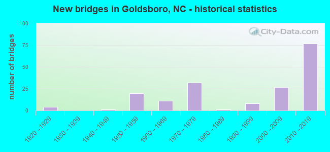
- New bridges - historical statistics
- 41920-1929
- 11940-1949
- 201950-1959
- 111960-1969
- 321970-1979
- 11980-1989
- 81990-1999
- 272000-2009
- 772010-2019
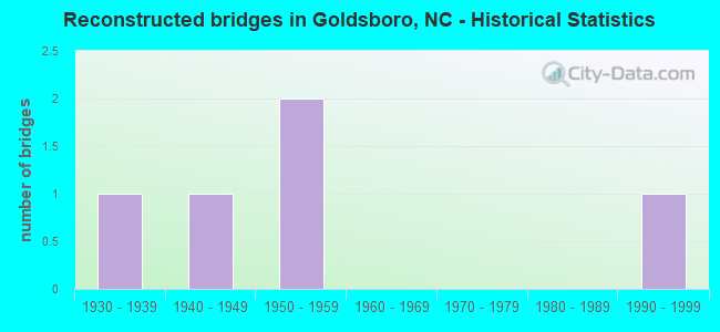
- Reconstructed bridges - Historical Statistics
- 11930-1939
- 11940-1949
- 21950-1959
- 01960-1969
- 01970-1979
- 01980-1989
- 11990-1999
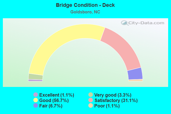
- Bridge Condition - Deck
- 1.1%Excellent
- 3.3%Very good
- 56.7%Good
- 31.1%Satisfactory
- 6.7%Fair
- 1.1%Poor
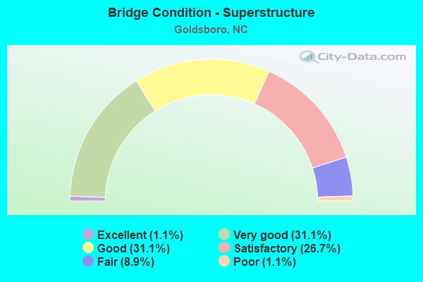
- Bridge Condition - Superstructure
- 1.1%Excellent
- 31.1%Very good
- 31.1%Good
- 26.7%Satisfactory
- 8.9%Fair
- 1.1%Poor
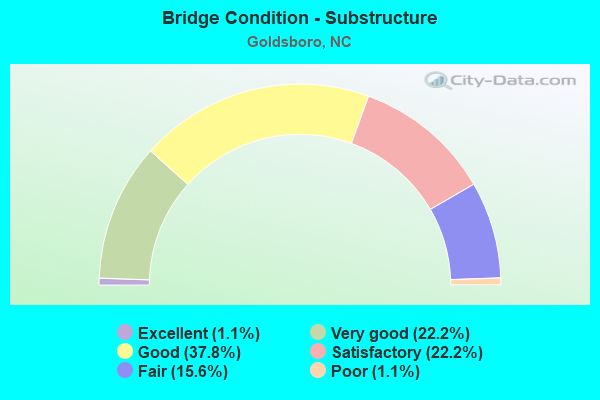
- Bridge Condition - Substructure
- 1.1%Excellent
- 22.2%Very good
- 37.8%Good
- 22.2%Satisfactory
- 15.6%Fair
- 1.1%Poor
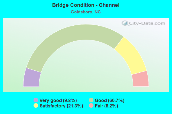
- Bridge Condition - Channel
- 9.8%Very good
- 60.7%Good
- 21.3%Satisfactory
- 8.2%Fair
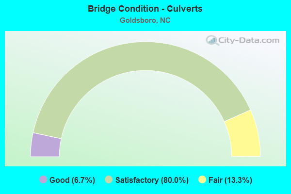
- Bridge Condition - Culverts
- 6.7%Good
- 80.0%Satisfactory
- 13.3%Fair
Find on map >> Show street view
Structure Number: 191036, Location: 0.7 MI. E. JCT. I795 (Lat: 35.425681, Lng: -77.980247), Route carried "under" structure: Alternate US 117, Year Built: 2012, Structure Length: 0. m, Average Daily Traffic: 4,750 (year 2018), Truck Traffic: 6%, Features Intersected: US70W,BYP.
Minimum Vertical Clearance: 5.71m (18.73ft), Kilometerpoint: 0.000, Lanes on structure: 3, Lanes under structure: 3, Material/Design: Steel, Design/Construction: Stringer/Multi-beam, Length of Maximum Span: 43.5m (142.7ft)
Find on map >> Show street view
Structure Number: 191036, Location: 0.7 MI. E. JCT. I795 (Lat: 35.425681, Lng: -77.980247), Route carried "under" structure: Alternate US 117, Year Built: 2012, Structure Length: 0. m, Average Daily Traffic: 4,750 (year 2018), Truck Traffic: 6%, Features Intersected: US70W,BYP.
Minimum Vertical Clearance: 6.19m (20.31ft), Kilometerpoint: 0.000, Lanes on structure: 3, Lanes under structure: 2, Material/Design: Steel, Design/Construction: Stringer/Multi-beam, Length of Maximum Span: 43.5m (142.7ft)
Find on map >> Show street view
Structure Number: 1910361, Location: 0.7 MI.E.JCT.I-795 (Lat: 35.425461, Lng: -77.980203), Route carried "under" structure: Alternate US 117, Year Built: 2012, Structure Length: 0. m, Average Daily Traffic: 4,750 (year 2018), Truck Traffic: 6%, Features Intersected: US70E,BYP.
Minimum Vertical Clearance: 6.45m (21.16ft), Kilometerpoint: 0.000, Lanes on structure: 3, Lanes under structure: 3, Material/Design: Steel, Design/Construction: Stringer/Multi-beam, Length of Maximum Span: 45.1m (148.0ft)
Find on map >> Show street view
Structure Number: 1910361, Location: 0.7 MI.E.JCT.I-795 (Lat: 35.425461, Lng: -77.980203), Route carried "under" structure: Alternate US 117, Year Built: 2012, Structure Length: 0. m, Average Daily Traffic: 4,750 (year 2018), Truck Traffic: 6%, Features Intersected: US70E,BYP.
Minimum Vertical Clearance: 5.81m (19.06ft), Kilometerpoint: 0.000, Lanes on structure: 3, Lanes under structure: 2, Material/Design: Steel, Design/Construction: Stringer/Multi-beam, Length of Maximum Span: 45.1m (148.0ft)
Find on map >> Show street view
Structure Number: 1910364, Location: 0.9 MI.E. OF JCT.US117 (Lat: 35.426567, Lng: -77.963636), Route carried "under" structure: State highway 111, Year Built: 2012, Structure Length: 0. m, Average Daily Traffic: 5,400 (year 2014), Truck Traffic: 6%, Features Intersected: NC44 WBL
Minimum Vertical Clearance: 5.00m (16.40ft), Kilometerpoint: 0.000, Lanes on structure: 2, Lanes under structure: 2, Material/Design: Prestressed concrete continuous, Design/Construction: Stringer/Multi-beam, Length of Maximum Span: 29.5m (96.8ft)
Find on map >> Show street view
Structure Number: 1910365, Location: 0.9 MI. E. JCT. US117 (Lat: 35.426356, Lng: -77.963653), Route carried "under" structure: State highway 111, Year Built: 2012, Structure Length: 0. m, Average Daily Traffic: 6,000 (year 2018), Truck Traffic: 6%, Features Intersected: US70E. BYP
Minimum Vertical Clearance: 4.80m (15.75ft), Kilometerpoint: 0.000, Lanes on structure: 2, Lanes under structure: 2, Material/Design: Prestressed concrete continuous, Design/Construction: Stringer/Multi-beam, Length of Maximum Span: 29.5m (96.8ft)
Find on map >> Show street view
Structure Number: 1910368, Location: 0.5 MI. S. JCT. SR1547 (Lat: 35.418833, Lng: -77.934864), Route carried "under" structure: Bypass US 70, Year Built: 2011, Structure Length: 0. m, Average Daily Traffic: 3,400 (year 2014), Truck Traffic: 12%, Features Intersected: SR1556
Minimum Vertical Clearance: 5.51m (18.08ft), Kilometerpoint: 109.272, Lanes on structure: 2, Lanes under structure: 2, Material/Design: Prestressed concrete continuous, Design/Construction: Stringer/Multi-beam, Length of Maximum Span: 28.3m (92.8ft)
Find on map >> Show street view
Structure Number: 1910368, Location: 0.5 MI. S. JCT. SR1547 (Lat: 35.418833, Lng: -77.934864), Route carried "under" structure: Bypass US 70, Year Built: 2011, Structure Length: 0. m, Average Daily Traffic: 3,400 (year 2014), Truck Traffic: 12%, Features Intersected: SR1556
Minimum Vertical Clearance: 5.68m (18.64ft), Kilometerpoint: 109.272, Lanes on structure: 2, Lanes under structure: 2, Material/Design: Prestressed concrete continuous, Design/Construction: Stringer/Multi-beam, Length of Maximum Span: 28.3m (92.8ft)
Find on map >> Show street view
Structure Number: 1910373, Location: @ JCT. US70 & NC44 (Lat: 35.433333, Lng: -78.066667), Route carried "under" structure: State highway 44, Year Built: 2014, Structure Length: 0. m, Average Daily Traffic: 10,300 (year 2012), Truck Traffic: 12%, Features Intersected: US70W
Minimum Vertical Clearance: 5.53m (18.14ft), Kilometerpoint: 0.000, Lanes on structure: 2, Lanes under structure: 2, Material/Design: Steel continuous, Design/Construction: Stringer/Multi-beam, Length of Maximum Span: 58.2m (190.9ft)
Find on map >> Show street view
Structure Number: 1910373, Location: @ JCT. US70 & NC44 (Lat: 35.433333, Lng: -78.066667), Route carried "under" structure: State highway 44, Year Built: 2014, Structure Length: 0. m, Average Daily Traffic: 10,300 (year 2012), Truck Traffic: 12%, Features Intersected: US70W
Minimum Vertical Clearance: 5.25m (17.22ft), Kilometerpoint: 0.000, Lanes on structure: 2, Lanes under structure: 2, Material/Design: Steel continuous, Design/Construction: Stringer/Multi-beam, Length of Maximum Span: 58.2m (190.9ft)
Find on map >> Show street view
Structure Number: 1910374, Location: 0.5 MI. N US70 (Lat: 35.433100, Lng: -78.056600), Route carried "under" structure: US 70, Year Built: 2014, Structure Length: 0. m, Average Daily Traffic: 3,000 (year 2013), Truck Traffic: 6%, Features Intersected: NC581
Minimum Vertical Clearance: 5.33m (17.49ft), Kilometerpoint: 107.168, Lanes on structure: 3, Lanes under structure: 2, Material/Design: Prestressed concrete continuous, Design/Construction: Stringer/Multi-beam, Length of Maximum Span: 31.3m (102.7ft)
Find on map >> Show street view
Structure Number: 1910374, Location: 0.5 MI. N US70 (Lat: 35.433100, Lng: -78.056600), Route carried "under" structure: US 70, Year Built: 2014, Structure Length: 0. m, Average Daily Traffic: 3,000 (year 2013), Truck Traffic: 6%, Features Intersected: NC581
Minimum Vertical Clearance: 5.38m (17.65ft), Kilometerpoint: 107.168, Lanes on structure: 3, Lanes under structure: 3, Material/Design: Prestressed concrete continuous, Design/Construction: Stringer/Multi-beam, Length of Maximum Span: 31.3m (102.7ft)
Find on map >> Show street view
Structure Number: 1910375, Location: 1 MI. W. JCT. I795 (Lat: 35.426389, Lng: -78.017500), Route carried "under" structure: State highway 1326, Year Built: 2015, Structure Length: 0. m, Average Daily Traffic: 300 (year 2018), Truck Traffic: 7%, Features Intersected: US70W.BYP
Minimum Vertical Clearance: 4.80m (15.75ft), Kilometerpoint: 0.000, Lanes on structure: 2, Lanes under structure: 2, Material/Design: Prestressed concrete continuous, Design/Construction: Tee Beam, Length of Maximum Span: 35.3m (115.8ft)
Find on map >> Show street view
Structure Number: 1910376, Location: 1 MI.W. JCT. I795 (Lat: 35.426111, Lng: -78.017500), Route carried "under" structure: State highway 1326, Year Built: 2015, Structure Length: 0. m, Average Daily Traffic: 3,000 (year 2018), Truck Traffic: 7%, Features Intersected: I70E,BYP.
Minimum Vertical Clearance: 4.91m (16.11ft), Kilometerpoint: 0.000, Lanes on structure: 2, Lanes under structure: 2, Material/Design: Prestressed concrete continuous, Design/Construction: Tee Beam, Length of Maximum Span: 35.3m (115.8ft)
Find on map >> Show street view
Structure Number: 1910377, Location: 0.4 MI. E. JCT. US70W (Lat: 35.428333, Lng: -77.996667), Route carried "under" structure: US 70, Year Built: 2015, Structure Length: 0. m, Average Daily Traffic: 13,750 (year 2018), Truck Traffic: 12%, Features Intersected: US70W.BYP.RAMP
Minimum Vertical Clearance: 12.43m (40.78ft), Kilometerpoint: 0.000, Lanes on structure: 2, Lanes under structure: 2, Material/Design: Steel continuous, Design/Construction: Stringer/Multi-beam, Length of Maximum Span: 46.3m (151.9ft)
Find on map >> Show street view
Structure Number: 1910377, Location: 0.4 MI. E. JCT. US70W (Lat: 35.428333, Lng: -77.996667), Route carried "under" structure: US 70, Year Built: 2015, Structure Length: 0. m, Average Daily Traffic: 13,750 (year 2018), Truck Traffic: 12%, Features Intersected: US70W.BYP.RAMP
Minimum Vertical Clearance: 12.55m (41.17ft), Kilometerpoint: 0.000, Lanes on structure: 2, Lanes under structure: 2, Material/Design: Steel continuous, Design/Construction: Stringer/Multi-beam, Length of Maximum Span: 46.3m (151.9ft)
Find on map >> Show street view
Structure Number: 1910377, Location: 0.4 MI. E. JCT. US70W (Lat: 35.428333, Lng: -77.996667), Route carried "under" structure: State highway 1300, Year Built: 2015, Structure Length: 0. m, Average Daily Traffic: 4,300 (year 2018), Truck Traffic: 7%, Features Intersected: US70W.BYP.RAMP
Minimum Vertical Clearance: 4.86m (15.94ft), Kilometerpoint: 0.000, Lanes on structure: 2, Lanes under structure: 2, Material/Design: Steel continuous, Design/Construction: Stringer/Multi-beam, Length of Maximum Span: 46.3m (151.9ft)
Find on map >> Show street view
Structure Number: 1910377, Location: 0.4 MI. E. JCT. US70W (Lat: 35.428333, Lng: -77.996667), Route carried "under" structure: US 70, Year Built: 2015, Structure Length: 0. m, Average Daily Traffic: 13,750 (year 2018), Truck Traffic: 12%, Features Intersected: US70W.BYP.RAMP
Minimum Vertical Clearance: 12.83m (42.09ft), Kilometerpoint: 0.000, Lanes on structure: 2, Lanes under structure: 1, Material/Design: Steel continuous, Design/Construction: Stringer/Multi-beam, Length of Maximum Span: 46.3m (151.9ft)
Find on map >> Show street view
Structure Number: 1910378, Location: 0.5 MI. N. JCT I795 (Lat: 35.427969, Lng: -77.996778), Route carried "under" structure: Ramp Interstate 795, Year Built: 2013, Structure Length: 0. m, Average Daily Traffic: 8,500 (year 2019), Truck Traffic: 16%, Features Intersected: SR1300
Minimum Vertical Clearance: 5.43m (17.81ft), Kilometerpoint: 0.000, Lanes on structure: 2, Lanes under structure: 2, Material/Design: Steel continuous, Design/Construction: Stringer/Multi-beam, Length of Maximum Span: 54.5m (178.8ft)
Find on map >> Show street view
Structure Number: 1910378, Location: 0.5 MI. N. JCT I795 (Lat: 35.427969, Lng: -77.996778), Route carried "under" structure: Ramp US 70, Year Built: 2013, Structure Length: 0. m, Average Daily Traffic: 9,250 (year 2019), Truck Traffic: 16%, Features Intersected: SR1300
Minimum Vertical Clearance: 5.57m (18.27ft), Kilometerpoint: 0.000, Lanes on structure: 2, Lanes under structure: 1, Material/Design: Steel continuous, Design/Construction: Stringer/Multi-beam, Length of Maximum Span: 54.5m (178.8ft)
Find on map >> Show street view
Structure Number: 1910378, Location: 0.5 MI. N. JCT I795 (Lat: 35.427969, Lng: -77.996778), Route carried "under" structure: Bypass US 70, Year Built: 2013, Structure Length: 0. m, Average Daily Traffic: 13,500 (year 2018), Truck Traffic: 12%, Features Intersected: SR1300
Minimum Vertical Clearance: 5.58m (18.31ft), Kilometerpoint: 0.000, Lanes on structure: 2, Lanes under structure: 2, Material/Design: Steel continuous, Design/Construction: Stringer/Multi-beam, Length of Maximum Span: 54.5m (178.8ft)
Find on map >> Show street view
Structure Number: 1910378, Location: 0.5 MI. N. JCT I795 (Lat: 35.427969, Lng: -77.996778), Route carried "under" structure: Bypass US 70, Year Built: 2013, Structure Length: 0. m, Average Daily Traffic: 13,500 (year 2018), Truck Traffic: 12%, Features Intersected: SR1300
Minimum Vertical Clearance: 5.48m (17.98ft), Kilometerpoint: 0.000, Lanes on structure: 2, Lanes under structure: 2, Material/Design: Steel continuous, Design/Construction: Stringer/Multi-beam, Length of Maximum Span: 54.5m (178.8ft)
Find on map >> Show street view
Structure Number: 1910385, Location: 0.4 MI. N. JCT. SR1571 (Lat: 34.706028, Lng: -78.535386), Route carried "under" structure: Bypass US 70, Year Built: 2015, Structure Length: 0. m, Average Daily Traffic: 10,750 (year 2018), Truck Traffic: 12%, Features Intersected: SR1570
Minimum Vertical Clearance: 5.68m (18.64ft), Kilometerpoint: 0.000, Lanes on structure: 2, Lanes under structure: 2, Material/Design: Prestressed concrete continuous, Design/Construction: Stringer/Multi-beam, Length of Maximum Span: 30.4m (99.7ft)
Find on map >> Show street view
Structure Number: 1910385, Location: 0.4 MI. N. JCT. SR1571 (Lat: 34.706028, Lng: -78.535386), Route carried "under" structure: Bypass US 70, Year Built: 2015, Structure Length: 0. m, Average Daily Traffic: 10,750 (year 2018), Truck Traffic: 12%, Features Intersected: SR1570
Minimum Vertical Clearance: 5.71m (18.73ft), Kilometerpoint: 0.000, Lanes on structure: 2, Lanes under structure: 2, Material/Design: Prestressed concrete continuous, Design/Construction: Stringer/Multi-beam, Length of Maximum Span: 30.4m (99.7ft)
Find on map >> Show street view
Structure Number: 1910386, Location: 0.2 MI. N. JCT. SR-1705 (Lat: 35.412086, Lng: -77.897344), Route carried "under" structure: Bypass US 70, Year Built: 2014, Structure Length: 0. m, Average Daily Traffic: 10,750 (year 2018), Truck Traffic: 12%, Features Intersected: US13
Minimum Vertical Clearance: 5.33m (17.49ft), Kilometerpoint: 110.034, Lanes on structure: 2, Lanes under structure: 2, Material/Design: Prestressed concrete continuous, Design/Construction: Stringer/Multi-beam, Length of Maximum Span: 27.7m (90.9ft)
Find on map >> Show street view
Structure Number: 1910386, Location: 0.2 MI. N. JCT. SR-1705 (Lat: 35.412086, Lng: -77.897344), Route carried "under" structure: Bypass US 70, Year Built: 2014, Structure Length: 0. m, Average Daily Traffic: 10,750 (year 2018), Truck Traffic: 12%, Features Intersected: US13
Minimum Vertical Clearance: 5.58m (18.31ft), Kilometerpoint: 110.034, Lanes on structure: 2, Lanes under structure: 2, Material/Design: Prestressed concrete continuous, Design/Construction: Stringer/Multi-beam, Length of Maximum Span: 27.7m (90.9ft)
Find on map >> Show street view
Structure Number: 1910387, Location: 0.5 MI. N. JCT. US13 (Lat: 35.400000, Lng: -77.883333), Route carried "under" structure: Bypass US 70, Year Built: 2015, Structure Length: 0. m, Average Daily Traffic: 8,000 (year 2018), Truck Traffic: 12%, Features Intersected: SR1705
Minimum Vertical Clearance: 5.63m (18.47ft), Kilometerpoint: 110.186, Lanes on structure: 2, Lanes under structure: 2, Material/Design: Prestressed concrete continuous, Design/Construction: Stringer/Multi-beam, Length of Maximum Span: 31.6m (103.7ft)
Find on map >> Show street view
Structure Number: 1910387, Location: 0.5 MI. N. JCT. US13 (Lat: 35.400000, Lng: -77.883333), Route carried "under" structure: Bypass US 70, Year Built: 2015, Structure Length: 0. m, Average Daily Traffic: 8,000 (year 2018), Truck Traffic: 12%, Features Intersected: SR1705
Minimum Vertical Clearance: 5.38m (17.65ft), Kilometerpoint: 110.186, Lanes on structure: 2, Lanes under structure: 2, Material/Design: Prestressed concrete continuous, Design/Construction: Stringer/Multi-beam, Length of Maximum Span: 31.6m (103.7ft)
Find on map >> Show street view
Structure Number: 1910388, Location: 0.4 MI. S, JCT. SR1705 (Lat: 35.403628, Lng: -77.878222), Route carried "under" structure: Bypass US 70, Year Built: 2015, Structure Length: 0. m, Average Daily Traffic: 8,000 (year 2018), Truck Traffic: 12%, Features Intersected: SR1708
Minimum Vertical Clearance: 5.38m (17.65ft), Kilometerpoint: 0.000, Lanes on structure: 2, Lanes under structure: 2, Material/Design: Prestressed concrete continuous, Design/Construction: Stringer/Multi-beam, Length of Maximum Span: 27.1m (88.9ft)
Find on map >> Show street view
Structure Number: 1910388, Location: 0.4 MI. S, JCT. SR1705 (Lat: 35.403628, Lng: -77.878222), Route carried "under" structure: Bypass US 70, Year Built: 2015, Structure Length: 0. m, Average Daily Traffic: 8,000 (year 2018), Truck Traffic: 12%, Features Intersected: SR1708
Minimum Vertical Clearance: 5.79m (19.00ft), Kilometerpoint: 0.000, Lanes on structure: 2, Lanes under structure: 2, Material/Design: Prestressed concrete continuous, Design/Construction: Stringer/Multi-beam, Length of Maximum Span: 27.1m (88.9ft)
Find on map >> Show street view
Structure Number: 1910389, Location: 1.12M. W. JCT. SR1719 (Lat: 35.380750, Lng: -77.863806), Route carried "under" structure: Bypass US 70, Year Built: 2018, Structure Length: 0. m, Average Daily Traffic: 6,500 (year 2016), Truck Traffic: 14%, Features Intersected: SR1714
Minimum Vertical Clearance: 5.43m (17.81ft), Kilometerpoint: 110.948, Lanes on structure: 2, Lanes under structure: 2, Material/Design: Prestressed concrete continuous, Design/Construction: Stringer/Multi-beam, Length of Maximum Span: 28.6m (93.8ft)
Find on map >> Show street view
Structure Number: 1910389, Location: 1.12M. W. JCT. SR1719 (Lat: 35.380750, Lng: -77.863806), Route carried "under" structure: Bypass US 70, Year Built: 2018, Structure Length: 0. m, Average Daily Traffic: 6,500 (year 2016), Truck Traffic: 14%, Features Intersected: SR1714
Minimum Vertical Clearance: 5.58m (18.31ft), Kilometerpoint: 110.948, Lanes on structure: 2, Lanes under structure: 2, Material/Design: Prestressed concrete continuous, Design/Construction: Stringer/Multi-beam, Length of Maximum Span: 28.6m (93.8ft)