Bridge Statistics for Greenville, North Carolina (NC)
Condition, Traffic, Stress, Structural Evaluation, Project Costs
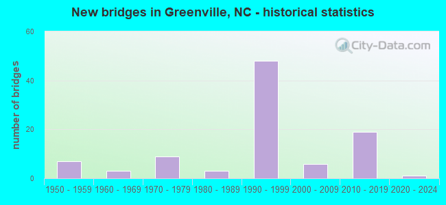
- New bridges - historical statistics
- 71950-1959
- 61960-1969
- 121970-1979
- 61980-1989
- 521990-1999
- 72000-2009
- 432010-2019


- Bridge Condition - Deck
- 23.9%Very good
- 47.8%Good
- 20.9%Satisfactory
- 7.5%Fair

- Bridge Condition - Superstructure
- 37.3%Very good
- 37.3%Good
- 16.4%Satisfactory
- 6.0%Fair
- 1.5%Poor
- 1.5%Serious

- Bridge Condition - Substructure
- 25.4%Very good
- 50.7%Good
- 14.9%Satisfactory
- 7.5%Fair
- 1.5%Serious

- Bridge Condition - Channel
- 1.4%Very good
- 71.0%Good
- 23.2%Satisfactory
- 4.3%Fair

- Bridge Condition - Culverts
- 11.1%Very good
- 63.0%Good
- 14.8%Satisfactory
- 7.4%Fair
- 3.7%Poor
Find on map >> Show street view
Structure Number: 1470501, Location: 1.0 MI. S. OF JCT. US13 (Lat: 35.545850, Lng: -77.461964), Route carried "on" structure: Bypass State highway 11, Year Built: 2019, Status: Open, Structure Length: 3.77m (12.37ft), Average Daily Traffic: 9,500 (year 2018), Truck Traffic: 14%, Average Future Daily Traffic: 19,000 (year 2040), Design Load: HL 93, Features Intersected: SR1126
Minimum Vertical Clearance: 30+ m (98+ ft), Kilometerpoint: 36.195, Lanes on structure: 2, Lanes under structure: 4, Base Highway Network: Yes (Inventory Route: 3, Subroute: 11), Owner: State Highway Agency, Approaching Roadway Width: 11.8m (38.7ft), Skew: 1 degrees, Material/Design: Prestressed concrete, Design/Construction: Stringer/Multi-beam, Number Of Spans In Main Unit: 1, Length of Maximum Span: 36.5m (119.8ft), Curb-To-Curb Width: 12.6m (41.3ft), Out-to-Out Width: 13.7m (44.9ft)
Condition: Deck: Good, Superstructure: Very good, Substructure: Very good, Operating Rating: 85.2 metric tons, Method Used To Determine Operating Rating: Load and Resistance Factor (LRFR), Inventory Rating: 55.3 metric tons, Method Used To Determine Inventory Rating: Load and Resistance Factor (LRFR), Structural Evaluation: Equal to present desirable criteria, Deck Geometry: Better than present minimum criteria, Underclear: Better than present minimum criteria, Approach Roadway Alignment: Equal to present desirable criteria, Designated Inspection Frequency: Every 24 months, Inspection Date: October 2021, Deck Structure Type: Concrete Cast-file-Place, Wearing Surface/Protective System: Wearing Surface: Monolithic Concrete
Find on map >> Show street view
Structure Number: 1470502, Location: 0.4 MI. N. JCT. SR1128 (Lat: 35.561881, Lng: -77.461789), Route carried "on" structure: State highway 11, Year Built: 2019, Status: Open, Structure Length: 5.76m (18.90ft), Average Daily Traffic: 9,000 (year 2018), Truck Traffic: 14%, Average Future Daily Traffic: 18,000 (year 2040), Design Load: HL 93, Features Intersected: US13/264 ALT
Minimum Vertical Clearance: 30+ m (98+ ft), Kilometerpoint: 0.000, Lanes on structure: 2, Lanes under structure: 4, Base Highway Network: Yes (Inventory Route: 3, Subroute: 11), Owner: State Highway Agency, Approaching Roadway Width: 12.8m (42.0ft), Skew: 2 degrees, Material/Design: Prestressed concrete continuous, Design/Construction: Stringer/Multi-beam, Number Of Spans In Main Unit: 2, Length of Maximum Span: 27.7m (90.9ft), Curb-To-Curb Width: 12.8m (42.0ft), Out-to-Out Width: 13.7m (44.9ft)
Condition: Deck: Very good, Superstructure: Very good, Substructure: Very good, Operating Rating: 71.6 metric tons, Method Used To Determine Operating Rating: Load and Resistance Factor (LRFR), Inventory Rating: 58.0 metric tons, Method Used To Determine Inventory Rating: Load and Resistance Factor (LRFR), Structural Evaluation: Equal to present desirable criteria, Deck Geometry: Equal to present desirable criteria, Underclear: Equal to present minimum criteria, Approach Roadway Alignment: Equal to present desirable criteria, Designated Inspection Frequency: Every 24 months, Inspection Date: January 2022, Deck Structure Type: Concrete Cast-file-Place, Wearing Surface/Protective System: Wearing Surface: Monolithic Concrete, Deck Protection: Epoxy Coated Reinforcing
Find on map >> Show street view
Structure Number: 1470503, Location: 1.0 MI. N. JCT. SR1126 (Lat: 35.561675, Lng: -77.462044), Route carried "on" structure: Bypass State highway 11, Year Built: 2019, Status: Open, Structure Length: 5.76m (18.90ft), Average Daily Traffic: 9,500 (year 2018), Truck Traffic: 14%, Average Future Daily Traffic: 19,000 (year 2040), Design Load: HL 93, Features Intersected: US13,US264A
Minimum Vertical Clearance: 30+ m (98+ ft), Kilometerpoint: 36.271, Lanes on structure: 2, Lanes under structure: 4, Owner: State Highway Agency, Approaching Roadway Width: 12.8m (42.0ft), Skew: 2 degrees, Material/Design: Prestressed concrete continuous, Design/Construction: Stringer/Multi-beam, Number Of Spans In Main Unit: 2, Length of Maximum Span: 27.7m (90.9ft), Curb-To-Curb Width: 12.7m (41.7ft), Out-to-Out Width: 13.7m (44.9ft)
Condition: Deck: Good, Superstructure: Good, Substructure: Good, Operating Rating: 71.6 metric tons, Method Used To Determine Operating Rating: Load and Resistance Factor (LRFR), Inventory Rating: 46.2 metric tons, Method Used To Determine Inventory Rating: Load and Resistance Factor (LRFR), Structural Evaluation: Better than present minimum criteria, Deck Geometry: Better than present minimum criteria, Underclear: Equal to present minimum criteria, Approach Roadway Alignment: Equal to present desirable criteria, Designated Inspection Frequency: Every 24 months, Inspection Date: October 2021, Deck Structure Type: Concrete Cast-file-Place, Wearing Surface/Protective System: Wearing Surface: Monolithic Concrete, Deck Protection: Epoxy Coated Reinforcing
Find on map >> Show street view
Structure Number: 1470505, Location: 1 MI. N. JCT. US13/US264 (Lat: 35.585000, Lng: -77.464167), Route carried "on" structure: Bypass US 264, Year Built: 2018, Status: Open, Structure Length: 3.65m (11.98ft), Average Daily Traffic: 8,001 (year 2018), Truck Traffic: 14%, Average Future Daily Traffic: 16,000 (year 2040), Design Load: HL 93, Features Intersected: SR1127
Minimum Vertical Clearance: 30+ m (98+ ft), Kilometerpoint: 36.881, Lanes on structure: 2, Lanes under structure: 2, Base Highway Network: Yes (Inventory Route: 2, Subroute: 64), Owner: State Highway Agency, Approaching Roadway Width: 12.8m (42.0ft), Skew: 12 degrees, Material/Design: Prestressed concrete, Design/Construction: Stringer/Multi-beam, Number Of Spans In Main Unit: 1, Length of Maximum Span: 35.6m (116.8ft), Curb-To-Curb Width: 12.6m (41.3ft), Out-to-Out Width: 13.7m (44.9ft)
Condition: Deck: Very good, Superstructure: Good, Substructure: Very good, Operating Rating: 64.4 metric tons, Method Used To Determine Operating Rating: Load and Resistance Factor (LRFR), Inventory Rating: 47.1 metric tons, Method Used To Determine Inventory Rating: Load and Resistance Factor (LRFR), Structural Evaluation: Better than present minimum criteria, Deck Geometry: Better than present minimum criteria, Underclear: Somewhat better than minimum adequacy, Approach Roadway Alignment: Equal to present desirable criteria, Designated Inspection Frequency: Every 24 months, Inspection Date: November 2020, Deck Structure Type: Concrete Precast Panels, Wearing Surface/Protective System: Wearing Surface: Monolithic Concrete, Deck Protection: Epoxy Coated Reinforcing
Find on map >> Show street view
Structure Number: 1470507, Location: 0.8 MI. S. JCT. US264 INT (Lat: 35.596611, Lng: -77.446322), Route carried "on" structure: City street , Year Built: 2019, Status: Open, Structure Length: 7.74m (25.39ft), Average Daily Traffic: 9,000 (year 2018), Truck Traffic: 7%, Average Future Daily Traffic: 18,000 (year 2040), Design Load: HL 93, Features Intersected: CAROLINA COAST RR, Facility Carried by Structure: GREENVILLESW.BYP
Minimum Vertical Clearance: 30+ m (98+ ft), Kilometerpoint: 0.000, Lanes on structure: 2, Owner: City or Municipal Highway Agency, Approaching Roadway Width: 13.1m (43.0ft), Skew: 4 degrees, Material/Design: Prestressed concrete, Design/Construction: Slab, Number Of Spans In Main Unit: 3, Length of Maximum Span: 41.4m (135.8ft), Curb-To-Curb Width: 12.9m (42.3ft), Out-to-Out Width: 14.0m (45.9ft)
Condition: Deck: Good, Superstructure: Very good, Substructure: Very good, Operating Rating: 83.4 metric tons, Method Used To Determine Operating Rating: Load and Resistance Factor (LRFR), Inventory Rating: 58.0 metric tons, Method Used To Determine Inventory Rating: Load and Resistance Factor (LRFR), Structural Evaluation: Equal to present desirable criteria, Deck Geometry: Superior to present desirable criteria, Underclear: Superior to present desirable criteria, Approach Roadway Alignment: Equal to present desirable criteria, Designated Inspection Frequency: Every 24 months, Inspection Date: March 2020, Deck Structure Type: Concrete Cast-file-Place, Wearing Surface/Protective System: Wearing Surface: Monolithic Concrete
Find on map >> Show street view
Structure Number: 1470508, Location: 0.6 MI. S. JCT. US264 (Lat: 35.599722, Lng: -77.442783), Route carried "on" structure: State highway 11, Year Built: 2019, Status: Open, Structure Length: 3.71m (12.17ft), Average Daily Traffic: 9,000 (year 2018), Truck Traffic: 12%, Average Future Daily Traffic: 18,000 (year 2040), Design Load: HL 93, Features Intersected: SR1200
Minimum Vertical Clearance: 30+ m (98+ ft), Kilometerpoint: 37.414, Lanes on structure: 2, Lanes under structure: 2, Base Highway Network: Yes (Inventory Route: 3, Subroute: 11), Owner: State Highway Agency, Approaching Roadway Width: 12.4m (40.7ft), Skew: 3 degrees, Material/Design: Prestressed concrete, Design/Construction: Slab, Number Of Spans In Main Unit: 1, Length of Maximum Span: 35.0m (114.8ft), Curb-To-Curb Width: 12.8m (42.0ft), Out-to-Out Width: 13.8m (45.3ft)
Condition: Deck: Good, Superstructure: Very good, Substructure: Good, Operating Rating: 81.6 metric tons, Method Used To Determine Operating Rating: Load and Resistance Factor (LRFR), Inventory Rating: 51.7 metric tons, Method Used To Determine Inventory Rating: Load and Resistance Factor (LRFR), Structural Evaluation: Better than present minimum criteria, Deck Geometry: Equal to present desirable criteria, Underclear: Meets minimum limits, Approach Roadway Alignment: Equal to present desirable criteria, Designated Inspection Frequency: Every 24 months, Inspection Date: October 2021, Deck Structure Type: Concrete Cast-file-Place, Wearing Surface/Protective System: Wearing Surface: Monolithic Concrete, Deck Protection: Epoxy Coated Reinforcing
Find on map >> Show street view
Structure Number: 1470509, Location: 0.6 MI. S. US264 &SR1467 (Lat: 35.600000, Lng: -77.433494), Route carried "on" structure: Bypass State highway 11, Year Built: 2019, Status: Open, Structure Length: 3.71m (12.17ft), Average Daily Traffic: 9,000 (year 2018), Truck Traffic: 12%, Average Future Daily Traffic: 18,000 (year 2040), Design Load: HL 93, Features Intersected: SR1200
Minimum Vertical Clearance: 30+ m (98+ ft), Kilometerpoint: 0.000, Lanes on structure: 2, Lanes under structure: 2, Owner: State Highway Agency, Approaching Roadway Width: 12.8m (42.0ft), Skew: 3 degrees, Material/Design: Prestressed concrete, Design/Construction: Stringer/Multi-beam, Number Of Spans In Main Unit: 1, Length of Maximum Span: 35.3m (115.8ft), Curb-To-Curb Width: 12.8m (42.0ft), Out-to-Out Width: 13.8m (45.3ft)
Condition: Deck: Very good, Superstructure: Very good, Substructure: Very good, Operating Rating: 81.6 metric tons, Method Used To Determine Operating Rating: Load and Resistance Factor (LRFR), Inventory Rating: 50.8 metric tons, Method Used To Determine Inventory Rating: Load and Resistance Factor (LRFR), Structural Evaluation: Equal to present desirable criteria, Deck Geometry: Equal to present desirable criteria, Underclear: Meets minimum limits, Approach Roadway Alignment: Equal to present desirable criteria, Designated Inspection Frequency: Every 24 months, Inspection Date: December 2021, Deck Structure Type: Concrete Cast-file-Place, Wearing Surface/Protective System: Wearing Surface: Monolithic Concrete, Deck Protection: Epoxy Coated Reinforcing
Find on map >> Show street view
Structure Number: 147051, Location: 0.35M. E. JCT. US13/US264 (Lat: 35.556036, Lng: -77.461119), Route carried "on" structure: State highway 1128, Year Built: 2017, Status: Open, Structure Length: 7.46m (24.48ft), Average Daily Traffic: 5,200 (year 2018), Truck Traffic: 7%, Average Future Daily Traffic: 10,400 (year 2040), Design Load: HL 93, Features Intersected: US264BYP.
Minimum Vertical Clearance: 30+ m (98+ ft), Kilometerpoint: 0.000, Lanes on structure: 2, Lanes under structure: 4, Owner: State Highway Agency, Approaching Roadway Width: 12.1m (39.7ft), Skew: 3 degrees, Material/Design: Prestressed concrete, Design/Construction: Stringer/Multi-beam, Number Of Spans In Main Unit: 2, Length of Maximum Span: 35.9m (117.8ft), Curb-To-Curb Width: 12.1m (39.7ft), Out-to-Out Width: 13.1m (43.0ft)
Condition: Deck: Very good, Superstructure: Very good, Substructure: Very good, Operating Rating: 68.0 metric tons, Method Used To Determine Operating Rating: Load and Resistance Factor (LRFR), Inventory Rating: 47.1 metric tons, Method Used To Determine Inventory Rating: Load and Resistance Factor (LRFR), Structural Evaluation: Equal to present desirable criteria, Deck Geometry: Somewhat better than minimum adequacy, Underclear: Meets minimum limits, Approach Roadway Alignment: Equal to present desirable criteria, Designated Inspection Frequency: Every 24 months, Inspection Date: June 2021, Deck Structure Type: Concrete Cast-file-Place, Wearing Surface/Protective System: Wearing Surface: Monolithic Concrete, Deck Protection: Epoxy Coated Reinforcing
Find on map >> Show street view
Structure Number: 1191337, Location: BT.HAMIL.ST.& OAKLAWN AVE (Lat: 35.244586, Lng: -80.847061), Route carried "under" structure: Interstate 77, Year Built: 2019, Structure Length: 0. m, Average Daily Traffic: 51,000 (year 2018), Truck Traffic: 16%, Features Intersected: I277 RAMP FLYOVER
Minimum Vertical Clearance: 5.74m (18.83ft), Kilometerpoint: 0.000, Lanes on structure: 2, Lanes under structure: 2, Material/Design: Prestressed concrete, Design/Construction: Stringer/Multi-beam, Length of Maximum Span: 35.0m (114.8ft)
Find on map >> Show street view
Structure Number: 1191337, Location: BT.HAMIL.ST.& OAKLAWN AVE (Lat: 35.244586, Lng: -80.847061), Route carried "under" structure: Interstate 77, Year Built: 2019, Structure Length: 0. m, Average Daily Traffic: 51,000 (year 2018), Truck Traffic: 16%, Features Intersected: I277 RAMP FLYOVER
Minimum Vertical Clearance: 9.55m (31.33ft), Kilometerpoint: 0.000, Lanes on structure: 2, Lanes under structure: 5, Material/Design: Prestressed concrete, Design/Construction: Stringer/Multi-beam, Length of Maximum Span: 35.0m (114.8ft)
Find on map >> Show street view
Structure Number: 147045, Location: 0.61 MI. N. JCT. SR1204 (Lat: 35.629122, Lng: -77.433125), Route carried "under" structure: US 264, Year Built: 1991, Structure Length: 0. m, Average Daily Traffic: 9,000 (year 2018), Truck Traffic: 12%, Features Intersected: NC43
Minimum Vertical Clearance: 5.38m (17.65ft), Kilometerpoint: 22.738, Lanes on structure: 3, Lanes under structure: 2, Material/Design: Prestressed concrete, Design/Construction: Stringer/Multi-beam, Length of Maximum Span: 19.2m (63.0ft)
Find on map >> Show street view
Structure Number: 147045, Location: 0.61 MI. N. JCT. SR1204 (Lat: 35.629122, Lng: -77.433125), Route carried "under" structure: US 264, Year Built: 1991, Structure Length: 0. m, Average Daily Traffic: 9,000 (year 2018), Truck Traffic: 12%, Features Intersected: NC43
Minimum Vertical Clearance: 5.28m (17.32ft), Kilometerpoint: 22.738, Lanes on structure: 3, Lanes under structure: 2, Material/Design: Prestressed concrete, Design/Construction: Stringer/Multi-beam, Length of Maximum Span: 19.2m (63.0ft)
Find on map >> Show street view
Structure Number: 1470451, Location: 0.65 MI. W. JCT. SR1204 (Lat: 35.611347, Lng: -77.437556), Route carried "under" structure: US 264, Year Built: 1992, Structure Length: 0. m, Average Daily Traffic: 9,000 (year 2018), Truck Traffic: 12%, Features Intersected: SR1202
Minimum Vertical Clearance: 5.41m (17.75ft), Kilometerpoint: 22.433, Lanes on structure: 2, Lanes under structure: 3, Material/Design: Prestressed concrete, Design/Construction: Stringer/Multi-beam, Length of Maximum Span: 27.1m (88.9ft)
Find on map >> Show street view
Structure Number: 1470457, Location: 1.47 MI. W. JCT NC43 (Lat: 35.607625, Lng: -77.438031), Route carried "under" structure: Bypass US 264, Year Built: 1993, Structure Length: 0. m, Average Daily Traffic: 14,000 (year 2018), Truck Traffic: 12%, Features Intersected: US264E,BYP.
Minimum Vertical Clearance: 5.41m (17.75ft), Kilometerpoint: 22.250, Lanes on structure: 3, Lanes under structure: 2, Material/Design: Prestressed concrete, Design/Construction: Stringer/Multi-beam, Length of Maximum Span: 24.3m (79.7ft)
Find on map >> Show street view
Structure Number: 1470457, Location: 1.47 MI. W. JCT NC43 (Lat: 35.607625, Lng: -77.438031), Route carried "under" structure: Bypass US 264, Year Built: 1993, Structure Length: 0. m, Average Daily Traffic: 14,000 (year 2018), Truck Traffic: 12%, Features Intersected: US264E,BYP.
Minimum Vertical Clearance: 5.18m (16.99ft), Kilometerpoint: 22.250, Lanes on structure: 3, Lanes under structure: 4, Material/Design: Prestressed concrete, Design/Construction: Stringer/Multi-beam, Length of Maximum Span: 24.3m (79.7ft)
Find on map >> Show street view
Structure Number: 1470458, Location: 1.4 MI. W. JCT. NC43 (Lat: 35.607631, Lng: -77.438325), Route carried "under" structure: Bypass US 264, Year Built: 1993, Structure Length: 0. m, Average Daily Traffic: 10,500 (year 2014), Truck Traffic: 12%, Features Intersected: US264W
Minimum Vertical Clearance: 5.58m (18.31ft), Kilometerpoint: 22.250, Lanes on structure: 1, Lanes under structure: 2, Material/Design: Prestressed concrete, Design/Construction: Stringer/Multi-beam, Length of Maximum Span: 24.3m (79.7ft)
Find on map >> Show street view
Structure Number: 1470458, Location: 1.4 MI. W. JCT. NC43 (Lat: 35.607631, Lng: -77.438325), Route carried "under" structure: Bypass US 264, Year Built: 1993, Structure Length: 0. m, Average Daily Traffic: 10,500 (year 2014), Truck Traffic: 12%, Features Intersected: US264W
Minimum Vertical Clearance: 5.33m (17.49ft), Kilometerpoint: 22.250, Lanes on structure: 1, Lanes under structure: 4, Material/Design: Prestressed concrete, Design/Construction: Stringer/Multi-beam, Length of Maximum Span: 24.3m (79.7ft)
Find on map >> Show street view
Structure Number: 1470459, Location: 2.2MI.E.JCT.SR1402 (Lat: 35.650831, Lng: -77.418433), Route carried "under" structure: US 264, Year Built: 1993, Structure Length: 0. m, Average Daily Traffic: 10,000 (year 2018), Truck Traffic: 12%, Features Intersected: SR1401
Minimum Vertical Clearance: 5.23m (17.16ft), Kilometerpoint: 23.287, Lanes on structure: 2, Lanes under structure: 2, Material/Design: Prestressed concrete, Design/Construction: Stringer/Multi-beam, Length of Maximum Span: 26.8m (87.9ft)
Find on map >> Show street view
Structure Number: 1470459, Location: 2.2MI.E.JCT.SR1402 (Lat: 35.650831, Lng: -77.418433), Route carried "under" structure: US 264, Year Built: 1993, Structure Length: 0. m, Average Daily Traffic: 10,000 (year 2018), Truck Traffic: 12%, Features Intersected: SR1401
Minimum Vertical Clearance: 5.33m (17.49ft), Kilometerpoint: 23.287, Lanes on structure: 2, Lanes under structure: 2, Material/Design: Prestressed concrete, Design/Construction: Stringer/Multi-beam, Length of Maximum Span: 26.8m (87.9ft)
Find on map >> Show street view
Structure Number: 147046, Location: 0.3MI.E.JCT.SR1417 (Lat: 35.660344, Lng: -77.411475), Route carried "under" structure: US 264, Year Built: 1993, Structure Length: 0. m, Average Daily Traffic: 10,000 (year 2018), Truck Traffic: 12%, Features Intersected: NC33
Minimum Vertical Clearance: 5.51m (18.08ft), Kilometerpoint: 23.469, Lanes on structure: 3, Lanes under structure: 2, Material/Design: Prestressed concrete, Design/Construction: Stringer/Multi-beam, Length of Maximum Span: 18.8m (61.7ft)
Find on map >> Show street view
Structure Number: 147046, Location: 0.3MI.E.JCT.SR1417 (Lat: 35.660344, Lng: -77.411475), Route carried "under" structure: US 264, Year Built: 1993, Structure Length: 0. m, Average Daily Traffic: 10,000 (year 2018), Truck Traffic: 12%, Features Intersected: NC33
Minimum Vertical Clearance: 5.18m (16.99ft), Kilometerpoint: 23.469, Lanes on structure: 3, Lanes under structure: 2, Material/Design: Prestressed concrete, Design/Construction: Stringer/Multi-beam, Length of Maximum Span: 18.8m (61.7ft)
Find on map >> Show street view
Structure Number: 1470461, Location: 0.3MI.N.JCT.SR1418 (Lat: 35.664222, Lng: -77.388733), Route carried "under" structure: US 264, Year Built: 1993, Structure Length: 0. m, Average Daily Traffic: 8,250 (year 2018), Truck Traffic: 12%, Features Intersected: SR1419
Minimum Vertical Clearance: 5.48m (17.98ft), Kilometerpoint: 23.896, Lanes on structure: 2, Lanes under structure: 2, Material/Design: Prestressed concrete, Design/Construction: Stringer/Multi-beam, Length of Maximum Span: 18.8m (61.7ft)
Find on map >> Show street view
Structure Number: 1470461, Location: 0.3MI.N.JCT.SR1418 (Lat: 35.664222, Lng: -77.388733), Route carried "under" structure: US 264, Year Built: 1993, Structure Length: 0. m, Average Daily Traffic: 8,250 (year 2018), Truck Traffic: 12%, Features Intersected: SR1419
Minimum Vertical Clearance: 5.10m (16.73ft), Kilometerpoint: 23.896, Lanes on structure: 2, Lanes under structure: 2, Material/Design: Prestressed concrete, Design/Construction: Stringer/Multi-beam, Length of Maximum Span: 18.8m (61.7ft)
Find on map >> Show street view
Structure Number: 1470464, Location: 1 MI. W. JCT. SR1579 (Lat: 35.659003, Lng: -77.363408), Route carried "under" structure: US 13, Year Built: 1993, Structure Length: 0. m, Average Daily Traffic: 9,500 (year 2016), Truck Traffic: 12%, Features Intersected: US264E
Minimum Vertical Clearance: 7.44m (24.41ft), Kilometerpoint: 24.384, Lanes on structure: 3, Lanes under structure: 2, Material/Design: Steel, Design/Construction: Stringer/Multi-beam, Length of Maximum Span: 30.1m (98.8ft)
Find on map >> Show street view
Structure Number: 1470464, Location: 1 MI. W. JCT. SR1579 (Lat: 35.659003, Lng: -77.363408), Route carried "under" structure: US 13, Year Built: 1993, Structure Length: 0. m, Average Daily Traffic: 9,500 (year 2016), Truck Traffic: 12%, Features Intersected: US264E
Minimum Vertical Clearance: 7.34m (24.08ft), Kilometerpoint: 24.384, Lanes on structure: 3, Lanes under structure: 4, Material/Design: Steel, Design/Construction: Stringer/Multi-beam, Length of Maximum Span: 30.1m (98.8ft)
Find on map >> Show street view
Structure Number: 1470465, Location: 1.0 MI. W. JCT. SR1579 (Lat: 35.659222, Lng: -77.363353), Route carried "under" structure: US 13, Year Built: 1993, Structure Length: 0. m, Average Daily Traffic: 11,000 (year 2018), Truck Traffic: 12%, Features Intersected: US264W
Minimum Vertical Clearance: 7.39m (24.25ft), Kilometerpoint: 0.000, Lanes on structure: 3, Lanes under structure: 2, Material/Design: Steel, Design/Construction: Stringer/Multi-beam, Length of Maximum Span: 30.1m (98.8ft)
Find on map >> Show street view
Structure Number: 1470465, Location: 1.0 MI. W. JCT. SR1579 (Lat: 35.659222, Lng: -77.363353), Route carried "under" structure: US 13, Year Built: 1993, Structure Length: 0. m, Average Daily Traffic: 11,000 (year 2018), Truck Traffic: 12%, Features Intersected: US264W
Minimum Vertical Clearance: 7.23m (23.72ft), Kilometerpoint: 0.000, Lanes on structure: 3, Lanes under structure: 4, Material/Design: Steel, Design/Construction: Stringer/Multi-beam, Length of Maximum Span: 30.1m (98.8ft)
Find on map >> Show street view
Structure Number: 1470472, Location: 0.21 MI. N. JCT. SR1200 (Lat: 35.607903, Lng: -77.482767), Route carried "under" structure: US 264, Year Built: 1998, Structure Length: 0. m, Average Daily Traffic: 13,250 (year 2018), Truck Traffic: 12%, Features Intersected: SR1210
Minimum Vertical Clearance: 5.08m (16.67ft), Kilometerpoint: 21.641, Lanes on structure: 3, Lanes under structure: 2, Material/Design: Prestressed concrete continuous, Design/Construction: Stringer/Multi-beam, Length of Maximum Span: 26.2m (86.0ft)
Find on map >> Show street view
Structure Number: 1470496, Location: 2.2 M. S. JCT. SR1126 (Lat: 35.522222, Lng: -77.457500), Route carried "under" structure: State highway 903, Year Built: 2018, Structure Length: 0. m, Average Daily Traffic: 3,400 (year 2016), Truck Traffic: 7%, Features Intersected: US264N,SW BYP.
Minimum Vertical Clearance: 5.02m (16.47ft), Kilometerpoint: 0.000, Lanes on structure: 2, Lanes under structure: 2, Material/Design: Prestressed concrete, Design/Construction: Stringer/Multi-beam, Length of Maximum Span: 32.0m (105.0ft)
Find on map >> Show street view
Structure Number: 1470497, Location: 2.2 M. S. JCT. SR1126 (Lat: 35.521944, Lng: -77.457778), Route carried "under" structure: State highway 903, Year Built: 2018, Structure Length: 0. m, Average Daily Traffic: 3,400 (year 2016), Truck Traffic: 7%, Features Intersected: US264S, SW BYP.
Minimum Vertical Clearance: 4.82m (15.81ft), Kilometerpoint: 0.000, Lanes on structure: 2, Lanes under structure: 2, Material/Design: Prestressed concrete, Design/Construction: Stringer/Multi-beam, Length of Maximum Span: 32.0m (105.0ft)
Find on map >> Show street view
Structure Number: 1470498, Location: 1MI. S. JCT. FORLINES RD. (Lat: 35.527456, Lng: -77.464578), Route carried "under" structure: State highway 1125, Year Built: 2018, Structure Length: 0. m, Average Daily Traffic: 1,900 (year 2016), Truck Traffic: 6%, Features Intersected: US264BYP
Minimum Vertical Clearance: 4.74m (15.55ft), Kilometerpoint: 0.000, Lanes on structure: 2, Lanes under structure: 2, Material/Design: Prestressed concrete, Design/Construction: Stringer/Multi-beam, Length of Maximum Span: 25.9m (85.0ft)
Find on map >> Show street view
Structure Number: 1470499, Location: 1MI. S. JCT. US13 (Lat: 35.544103, Lng: -77.464842), Route carried "under" structure: State highway 1125, Year Built: 2018, Structure Length: 0. m, Average Daily Traffic: 1,900 (year 2016), Truck Traffic: 6%, Features Intersected: US264BYP.
Minimum Vertical Clearance: 4.97m (16.31ft), Kilometerpoint: 35.814, Lanes on structure: 2, Lanes under structure: 2, Material/Design: Prestressed concrete, Design/Construction: Stringer/Multi-beam, Length of Maximum Span: 25.9m (85.0ft)
Find on map >> Show street view
Structure Number: 14705, Location: 1 MI. S. JCT. US13 (Lat: 35.545933, Lng: -77.461897), Route carried "under" structure: Alternate State highway 1126, Year Built: 2018, Structure Length: 0. m, Average Daily Traffic: 4,700 (year 2016), Truck Traffic: 6%, Features Intersected: US264BYP.
Minimum Vertical Clearance: 5.00m (16.40ft), Kilometerpoint: 36.195, Lanes on structure: 2, Lanes under structure: 2, Material/Design: Prestressed concrete, Design/Construction: Stringer/Multi-beam, Length of Maximum Span: 36.5m (119.8ft)
Find on map >> Show street view
Structure Number: 14705, Location: 1 MI. S. JCT. US13 (Lat: 35.545933, Lng: -77.461897), Route carried "under" structure: State highway 1126, Year Built: 2018, Structure Length: 0. m, Average Daily Traffic: 4,700 (year 2016), Truck Traffic: 6%, Features Intersected: US264BYP.
Minimum Vertical Clearance: 4.95m (16.24ft), Kilometerpoint: 36.195, Lanes on structure: 2, Lanes under structure: 2, Material/Design: Prestressed concrete, Design/Construction: Stringer/Multi-beam, Length of Maximum Span: 36.5m (119.8ft)
Find on map >> Show street view
Structure Number: 1470501, Location: 1.0 MI. S. OF JCT. US13 (Lat: 35.545850, Lng: -77.461964), Route carried "under" structure: State highway 1126, Year Built: 2019, Structure Length: 0. m, Average Daily Traffic: 2,350 (year 2018), Truck Traffic: 6%, Features Intersected: NC11S.BYP
Minimum Vertical Clearance: 5.03m (16.50ft), Kilometerpoint: 36.195, Lanes on structure: 2, Lanes under structure: 2, Material/Design: Prestressed concrete, Design/Construction: Stringer/Multi-beam, Length of Maximum Span: 36.5m (119.8ft)
Find on map >> Show street view
Structure Number: 1470502, Location: 0.4 MI. N. JCT. SR1128 (Lat: 35.561881, Lng: -77.461789), Route carried "under" structure: Alternate US 13, Year Built: 2019, Structure Length: 0. m, Average Daily Traffic: 2,450 (year 2018), Truck Traffic: 8%, Features Intersected: NC11BYP
Minimum Vertical Clearance: 5.51m (18.08ft), Kilometerpoint: 0.000, Lanes on structure: 2, Lanes under structure: 2, Material/Design: Prestressed concrete continuous, Design/Construction: Stringer/Multi-beam, Length of Maximum Span: 27.7m (90.9ft)
Find on map >> Show street view
Structure Number: 1470502, Location: 0.4 MI. N. JCT. SR1128 (Lat: 35.561881, Lng: -77.461789), Route carried "under" structure: Alternate US 13, Year Built: 2019, Structure Length: 0. m, Average Daily Traffic: 2,450 (year 2018), Truck Traffic: 8%, Features Intersected: NC11BYP
Minimum Vertical Clearance: 5.56m (18.24ft), Kilometerpoint: 0.000, Lanes on structure: 2, Lanes under structure: 2, Material/Design: Prestressed concrete continuous, Design/Construction: Stringer/Multi-beam, Length of Maximum Span: 27.7m (90.9ft)
Find on map >> Show street view
Structure Number: 1470503, Location: 1.0 MI. N. JCT. SR1126 (Lat: 35.561675, Lng: -77.462044), Route carried "under" structure: Alternate US 13, Year Built: 2019, Structure Length: 0. m, Average Daily Traffic: 4,500 (year 2018), Truck Traffic: 6%, Features Intersected: NC11S.BYP
Minimum Vertical Clearance: 5.56m (18.24ft), Kilometerpoint: 0.000, Lanes on structure: 2, Lanes under structure: 2, Material/Design: Prestressed concrete continuous, Design/Construction: Stringer/Multi-beam, Length of Maximum Span: 27.7m (90.9ft)
Find on map >> Show street view
Structure Number: 1470503, Location: 1.0 MI. N. JCT. SR1126 (Lat: 35.561675, Lng: -77.462044), Route carried "under" structure: Alternate US 13, Year Built: 2019, Structure Length: 0. m, Average Daily Traffic: 4,500 (year 2018), Truck Traffic: 8%, Features Intersected: NC11S.BYP
Minimum Vertical Clearance: 5.48m (17.98ft), Kilometerpoint: 0.000, Lanes on structure: 2, Lanes under structure: 2, Material/Design: Prestressed concrete continuous, Design/Construction: Stringer/Multi-beam, Length of Maximum Span: 27.7m (90.9ft)
Find on map >> Show street view
Structure Number: 1470505, Location: 1 MI. N. JCT. US13/US264 (Lat: 35.585000, Lng: -77.464167), Route carried "under" structure: State highway 1127, Year Built: 2018, Structure Length: 0. m, Average Daily Traffic: 1,400 (year 2018), Truck Traffic: 6%, Features Intersected: US264S.BYP
Minimum Vertical Clearance: 4.95m (16.24ft), Kilometerpoint: 0.000, Lanes on structure: 2, Lanes under structure: 2, Material/Design: Prestressed concrete, Design/Construction: Stringer/Multi-beam, Length of Maximum Span: 35.6m (116.8ft)
Find on map >> Show street view
Structure Number: 1470508, Location: 0.6 MI. S. JCT. US264 (Lat: 35.599722, Lng: -77.442783), Route carried "under" structure: State highway 1200, Year Built: 2019, Structure Length: 0. m, Average Daily Traffic: 3,600 (year 2018), Truck Traffic: 6%, Features Intersected: NC11N,BYP.
Minimum Vertical Clearance: 5.46m (17.91ft), Kilometerpoint: 0.000, Lanes on structure: 2, Lanes under structure: 2, Material/Design: Prestressed concrete, Design/Construction: Slab, Length of Maximum Span: 35.0m (114.8ft)
Find on map >> Show street view
Structure Number: 1470509, Location: 0.6 MI. S. US264 &SR1467 (Lat: 35.600000, Lng: -77.433494), Route carried "under" structure: State highway 1200, Year Built: 2019, Structure Length: 0. m, Average Daily Traffic: 3,600 (year 2018), Truck Traffic: 6%, Features Intersected: NC11 BYP
Minimum Vertical Clearance: 5.38m (17.65ft), Kilometerpoint: 0.000, Lanes on structure: 2, Lanes under structure: 2, Material/Design: Prestressed concrete, Design/Construction: Stringer/Multi-beam, Length of Maximum Span: 35.3m (115.8ft)
Find on map >> Show street view
Structure Number: 147051, Location: 0.35M. E. JCT. US13/US264 (Lat: 35.556036, Lng: -77.461119), Route carried "under" structure: Bypass US 264, Year Built: 2017, Structure Length: 0. m, Average Daily Traffic: 9,000 (year 2018), Truck Traffic: 14%, Features Intersected: SR1128
Minimum Vertical Clearance: 5.48m (17.98ft), Kilometerpoint: 0.000, Lanes on structure: 2, Lanes under structure: 2, Material/Design: Prestressed concrete, Design/Construction: Stringer/Multi-beam, Length of Maximum Span: 35.9m (117.8ft)
Find on map >> Show street view
Structure Number: 147051, Location: 0.35M. E. JCT. US13/US264 (Lat: 35.556036, Lng: -77.461119), Route carried "under" structure: Bypass US 264, Year Built: 2017, Structure Length: 0. m, Average Daily Traffic: 9,000 (year 2018), Truck Traffic: 14%, Features Intersected: SR1128
Minimum Vertical Clearance: 5.43m (17.81ft), Kilometerpoint: 0.000, Lanes on structure: 2, Lanes under structure: 2, Material/Design: Prestressed concrete, Design/Construction: Stringer/Multi-beam, Length of Maximum Span: 35.9m (117.8ft)