Bridge Statistics for Jacksonville, North Carolina (NC)
Condition, Traffic, Stress, Structural Evaluation, Project Costs
- National Bridge Inventory (NBI) Statistics
- 121Number of bridges
- 2,405ft / 733mTotal length
- $359,000Total costs
- 1,507,446Total average daily traffic
- 149,185Total average daily truck traffic
- National Bridge Inventory (NBI) Registered Bridges for Jacksonville
- No street view available for this location
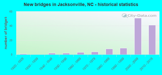
- New bridges - historical statistics
- 11920-1929
- 21940-1949
- 21950-1959
- 31960-1969
- 41970-1979
- 81980-1989
- 91990-1999
- 512000-2009
- 412010-2019


- Bridge Condition - Deck
- 6.8%Very good
- 68.9%Good
- 17.6%Satisfactory
- 6.8%Fair

- Bridge Condition - Superstructure
- 41.9%Very good
- 43.2%Good
- 9.5%Satisfactory
- 4.1%Fair
- 1.4%Poor

- Bridge Condition - Substructure
- 1.4%Excellent
- 13.5%Very good
- 58.1%Good
- 20.3%Satisfactory
- 4.1%Fair
- 1.4%Poor
- 1.4%Critical

- Bridge Condition - Channel
- 10.6%Very good
- 66.0%Good
- 10.6%Satisfactory
- 12.8%Fair

- Bridge Condition - Culverts
- 11.1%Good
- 44.4%Satisfactory
- 44.4%Fair
Find on map >> Show street view
Structure Number: 1330045, Location: 0.1 MI.S. OF NC24 (Lat: 34.955025, Lng: -77.567833), Route carried "on" structure: State highway 1213, Year Built: 1982, Status: Open, Structure Length: 1.09m (3.58ft), Average Daily Traffic: 5,100 (year 2012), Truck Traffic: 7%, Average Future Daily Traffic: 10,200 (year 2040), Design Load: HS 20+Mod, Features Intersected: BLUE CREEK
Minimum Vertical Clearance: 30+ m (98+ ft), Kilometerpoint: 0.000, Lanes on structure: 2, Owner: State Highway Agency, Approaching Roadway Width: 6.4m (21.0ft), Material/Design: Steel, Design/Construction: Culvert, Number Of Spans In Main Unit: 3, Length of Maximum Span: 2.7m (8.9ft)
Condition: Channel: Good, Culverts: Satisfactory, Operating Rating: 82.5 metric tons, Method Used To Determine Operating Rating: Load and Resistance Factor (LRFR), Inventory Rating: 63.5 metric tons, Method Used To Determine Inventory Rating: Load and Resistance Factor (LRFR), Structural Evaluation: Equal to present minimum criteria, Waterway Adequacy: Equal to present minimum criteria, Approach Roadway Alignment: Equal to present desirable criteria, Designated Inspection Frequency: Every 24 months, Inspection Date: Febuary 2022
Find on map >> Show street view
Structure Number: 1330072, Location: 1.5 MI S OF JCT NC53 (Lat: 34.719456, Lng: -77.522275), Route carried "on" structure: State highway 1105, Year Built: 1984, Status: Open, Structure Length: 5.21m (17.09ft), Average Daily Traffic: 4,200 (year 2017), Truck Traffic: 6%, Average Future Daily Traffic: 8,400 (year 2040), Design Load: HS 20+Mod, Features Intersected: SOUTHWEST CREEK
Minimum Vertical Clearance: 30+ m (98+ ft), Kilometerpoint: 0.000, Lanes on structure: 2, Owner: State Highway Agency, Approaching Roadway Width: 12.4m (40.7ft), Material/Design: Prestressed concrete, Design/Construction: Stringer/Multi-beam, Number Of Spans In Main Unit: 4, Length of Maximum Span: 12.4m (40.7ft), Curb-To-Curb Width: 12.1m (39.7ft), Out-to-Out Width: 13.0m (42.7ft)
Condition: Deck: Good, Superstructure: Good, Substructure: Good, Channel: Satisfactory, Operating Rating: 89.8 metric tons, Method Used To Determine Operating Rating: Load Factor (LF), Inventory Rating: 47.1 metric tons, Method Used To Determine Inventory Rating: Load Factor (LF), Structural Evaluation: Better than present minimum criteria, Deck Geometry: Somewhat better than minimum adequacy, Waterway Adequacy: Equal to present minimum criteria, Approach Roadway Alignment: Equal to present desirable criteria, Designated Inspection Frequency: Every 24 months, Inspection Date: January 2022, Deck Structure Type: Concrete Cast-file-Place, Wearing Surface/Protective System: Wearing Surface: Integral Concrete
Find on map >> Show street view
Structure Number: 1330118, Location: 0.3 MI W. OF JCT SR1410 (Lat: 34.774069, Lng: -77.361122), Route carried "on" structure: State highway 1406, Year Built: 2003, Status: Open, Structure Length: 2.43m (7.97ft), Average Daily Traffic: 27,500 (year 2018), Truck Traffic: 6%, Average Future Daily Traffic: 55,000 (year 2040), Design Load: HS 20+Mod, Features Intersected: N.E. CREEK OVERFLOW
Minimum Vertical Clearance: 30+ m (98+ ft), Kilometerpoint: 0.000, Lanes on structure: 3, Owner: State Highway Agency, Approaching Roadway Width: 16.1m (52.8ft), Material/Design: Prestressed concrete, Design/Construction: Slab, Number Of Spans In Main Unit: 2, Number Of Approach Spans: 2, Length of Maximum Span: 11.5m (37.7ft), Curb-To-Curb Width: 16.3m (53.5ft), Out-to-Out Width: 17.3m (56.8ft)
Condition: Deck: Good, Superstructure: Good, Substructure: Good, Channel: Good, Operating Rating: 76.2 metric tons, Method Used To Determine Operating Rating: Load Factor (LF), Inventory Rating: 45.3 metric tons, Method Used To Determine Inventory Rating: Load Factor (LF), Structural Evaluation: Better than present minimum criteria, Deck Geometry: Better than present minimum criteria, Waterway Adequacy: Better than present minimum criteria, Approach Roadway Alignment: Equal to present desirable criteria, Designated Inspection Frequency: Every 24 months, Underwater Inspection Frequency: Every 60 months, Inspection Date: Febuary 2022, Underwater Inspection Date: June 2018, Deck Structure Type: Concrete Precast Panels, Wearing Surface/Protective System: Wearing Surface: Bituminous
Find on map >> Show street view
Structure Number: 1330119, Location: 0.2 MI W. OF JCT.SR1410 (Lat: 34.773769, Lng: -77.360556), Route carried "on" structure: State highway 1406, Year Built: 2003, Status: Open, Structure Length: 3.04m (9.97ft), Average Daily Traffic: 24,000 (year 2012), Truck Traffic: 6%, Average Future Daily Traffic: 48,000 (year 2025), Design Load: HS 20+Mod, Features Intersected: NE CREEK MAIN STREAM
Minimum Vertical Clearance: 30+ m (98+ ft), Kilometerpoint: 0.000, Lanes on structure: 3, Owner: State Highway Agency, Approaching Roadway Width: 16.1m (52.8ft), Material/Design: Prestressed concrete, Design/Construction: Slab, Number Of Spans In Main Unit: 2, Number Of Approach Spans: 2, Length of Maximum Span: 14.6m (47.9ft), Curb-To-Curb Width: 16.4m (53.8ft), Out-to-Out Width: 17.3m (56.8ft)
Condition: Deck: Good, Superstructure: Good, Substructure: Satisfactory, Channel: Good, Operating Rating: 74.3 metric tons, Method Used To Determine Operating Rating: Load Factor (LF), Inventory Rating: 44.4 metric tons, Method Used To Determine Inventory Rating: Load Factor (LF), Structural Evaluation: Equal to present minimum criteria, Deck Geometry: Better than present minimum criteria, Waterway Adequacy: Better than present minimum criteria, Approach Roadway Alignment: Equal to present desirable criteria, Designated Inspection Frequency: Every 24 months, Underwater Inspection Frequency: Every 60 months, Inspection Date: Febuary 2022, Underwater Inspection Date: June 2019, Deck Structure Type: Concrete Precast Panels, Wearing Surface/Protective System: Wearing Surface: Bituminous
Find on map >> Show street view
Structure Number: 1330121, Location: 1.0 MI.E.JCT.SR1411 (Lat: 34.748286, Lng: -77.329250), Route carried "on" structure: State highway 1406, Year Built: 1994, Status: Open, Structure Length: 3.81m (12.50ft), Average Daily Traffic: 9,000 (year 2018), Truck Traffic: 6%, Average Future Daily Traffic: 18,000 (year 2040), Design Load: HS 20+Mod, Features Intersected: LITTLE NORTHEAST
Minimum Vertical Clearance: 30+ m (98+ ft), Kilometerpoint: 0.000, Lanes on structure: 2, Owner: State Highway Agency, Approaching Roadway Width: 10.9m (35.8ft), Material/Design: Prestressed concrete, Design/Construction: Slab, Number Of Spans In Main Unit: 3, Length of Maximum Span: 14.9m (48.9ft), Curb-To-Curb Width: 10.9m (35.8ft), Out-to-Out Width: 11.9m (39.0ft)
Condition: Deck: Very good, Superstructure: Very good, Substructure: Satisfactory, Channel: Fair, Operating Rating: 73.4 metric tons, Method Used To Determine Operating Rating: Load Factor (LF), Inventory Rating: 43.5 metric tons, Method Used To Determine Inventory Rating: Load Factor (LF), Structural Evaluation: Equal to present minimum criteria, Deck Geometry: Meets minimum limits, Waterway Adequacy: Better than present minimum criteria, Approach Roadway Alignment: Equal to present desirable criteria, Designated Inspection Frequency: Every 24 months, Underwater Inspection Frequency: Every 60 months, Inspection Date: March 2020, Underwater Inspection Date: June 2019, Deck Structure Type: Concrete Precast Panels, Wearing Surface/Protective System: Wearing Surface: Bituminous
Find on map >> Show street view
Structure Number: 1330123, Location: 0.3 MI E. OF JCT SR1308 (Lat: 34.826514, Lng: -77.453544), Route carried "on" structure: State highway 1324, Year Built: 1990, Status: Open, Structure Length: 0.85m (2.79ft), Average Daily Traffic: 4,300 (year 2012), Truck Traffic: 7%, Average Future Daily Traffic: 8,600 (year 2040), Design Load: HS 20+Mod, Features Intersected: BR HALF MOON CREEK
Minimum Vertical Clearance: 30+ m (98+ ft), Kilometerpoint: 0.000, Lanes on structure: 2, Owner: State Highway Agency, Approaching Roadway Width: 6.0m (19.7ft), Skew: 3 degrees, Material/Design: Steel, Design/Construction: Culvert, Number Of Spans In Main Unit: 2, Length of Maximum Span: 3.0m (9.8ft)
Condition: Channel: Good, Culverts: Satisfactory, Operating Rating: 89.8 metric tons, Method Used To Determine Operating Rating: Load and Resistance Factor (LRFR), Inventory Rating: 89.8 metric tons, Method Used To Determine Inventory Rating: Load and Resistance Factor (LRFR), Structural Evaluation: Equal to present minimum criteria, Waterway Adequacy: Better than present minimum criteria, Approach Roadway Alignment: Equal to present desirable criteria, Designated Inspection Frequency: Every 24 months, Inspection Date: March 2020
Find on map >> Show street view
Structure Number: 1330191, Location: 0.4 MI.E.JCT.US17 (Lat: 34.751281, Lng: -77.434594), Route carried "on" structure: State highway 1402, Year Built: 1988, Status: Open, Structure Length: 14.26m (46.78ft), Average Daily Traffic: 4,000 (year 2018), Truck Traffic: 6%, Average Future Daily Traffic: 8,000 (year 2040), Design Load: HS 20+Mod, Features Intersected: NEW RIVER
Minimum Vertical Clearance: 30+ m (98+ ft), Kilometerpoint: 0.000, Lanes on structure: 2, Owner: State Highway Agency, Approaching Roadway Width: 12.1m (39.7ft), Material/Design: Prestressed concrete, Design/Construction: Slab, Number Of Spans In Main Unit: 10, Length of Maximum Span: 13.7m (44.9ft), Curb or Sidewalk Widths: Left: 0.0m, Right: 1.4m (4.6ft), Curb-To-Curb Width: 12.1m (39.7ft), Out-to-Out Width: 14.6m (47.9ft)
Condition: Deck: Very good, Superstructure: Very good, Substructure: Satisfactory, Channel: Good, Operating Rating: 60.7 metric tons, Method Used To Determine Operating Rating: Load Factor (LF), Inventory Rating: 36.2 metric tons, Method Used To Determine Inventory Rating: Load Factor (LF), Structural Evaluation: Equal to present minimum criteria, Deck Geometry: Somewhat better than minimum adequacy, Waterway Adequacy: Better than present minimum criteria, Approach Roadway Alignment: Equal to present desirable criteria, Designated Inspection Frequency: Every 24 months, Underwater Inspection Frequency: Every 60 months, Inspection Date: January 2022, Underwater Inspection Date: September 2020, Deck Structure Type: Concrete Precast Panels, Wearing Surface/Protective System: Wearing Surface: Bituminous
Find on map >> Show street view
Structure Number: 1330209, Location: 1.3 MI W JCT SR1308 (Lat: 34.843150, Lng: -77.502814), Route carried "on" structure: State highway 1316, Year Built: 2014, Status: Open, Structure Length: 3.20m (10.50ft), Average Daily Traffic: 4,800 (year 2012), Truck Traffic: 7%, Average Future Daily Traffic: 9,600 (year 2040), Design Load: HL 93, Features Intersected: BRANCH OF NEW RIV
Minimum Vertical Clearance: 30+ m (98+ ft), Kilometerpoint: 0.000, Lanes on structure: 2, Owner: State Highway Agency, Approaching Roadway Width: 10.3m (33.8ft), Material/Design: Prestressed concrete, Design/Construction: Box Beam or Girders - Multiple, Number Of Spans In Main Unit: 1, Length of Maximum Span: 31.3m (102.7ft), Curb-To-Curb Width: 10.2m (33.5ft), Out-to-Out Width: 10.9m (35.8ft)
Condition: Deck: Very good, Superstructure: Very good, Substructure: Very good, Channel: Good, Operating Rating: 73.4 metric tons, Method Used To Determine Operating Rating: Load and Resistance Factor (LRFR), Inventory Rating: 45.3 metric tons, Method Used To Determine Inventory Rating: Load and Resistance Factor (LRFR), Structural Evaluation: Equal to present desirable criteria, Deck Geometry: Meets minimum limits, Waterway Adequacy: Better than present minimum criteria, Approach Roadway Alignment: Equal to present desirable criteria, Designated Inspection Frequency: Every 24 months, Inspection Date: March 2020, Deck Structure Type: Concrete Precast Panels, Wearing Surface/Protective System: Wearing Surface: Bituminous, Deck Protection: Epoxy Coated Reinforcing
Find on map >> Show street view
Structure Number: 1330223, Location: 0.6 MI N JCT US17 (Lat: 34.765583, Lng: -77.422486), Route carried "on" structure: State highway 1336, Year Built: 1974, Status: Open, Structure Length: 3.35m (10.99ft), Average Daily Traffic: 21,500 (year 2018), Truck Traffic: 6%, Average Future Daily Traffic: 30,000 (year 2040), Design Load: HS 20+Mod, Features Intersected: MILL CREEK
Minimum Vertical Clearance: 30+ m (98+ ft), Kilometerpoint: 0.000, Lanes on structure: 5, Owner: State Highway Agency, Approaching Roadway Width: 19.5m (64.0ft), Material/Design: Concrete continuous, Design/Construction: Slab, Number Of Spans In Main Unit: 5, Length of Maximum Span: 6.4m (21.0ft), Curb or Sidewalk Widths: Left: 1.5m (4.9ft), Right: 1.5m (4.9ft), Curb-To-Curb Width: 19.5m (64.0ft), Out-to-Out Width: 23.5m (77.1ft)
Condition: Deck: Fair, Superstructure: Satisfactory, Substructure: Satisfactory, Channel: Good, Operating Rating: 69.8 metric tons, Method Used To Determine Operating Rating: Load Factor (LF), Inventory Rating: 41.7 metric tons, Method Used To Determine Inventory Rating: Load Factor (LF), Structural Evaluation: Equal to present minimum criteria, Deck Geometry: Meets minimum limits, Waterway Adequacy: Better than present minimum criteria, Approach Roadway Alignment: Equal to present desirable criteria, Designated Inspection Frequency: Every 24 months, Underwater Inspection Frequency: Every 60 months, Inspection Date: Febuary 2022, Underwater Inspection Date: June 2019, Deck Structure Type: Concrete Cast-file-Place, Wearing Surface/Protective System: Wearing Surface: Monolithic Concrete
Find on map >> Show street view
Structure Number: 1330225, Location: 2.2 MI.W. OF JCT.SR1326 (Lat: 34.819675, Lng: -77.418058), Route carried "on" structure: State highway 1324, Year Built: 1988, Status: Open, Structure Length: 0.82m (2.69ft), Average Daily Traffic: 7,000 (year 2018), Truck Traffic: 7%, Average Future Daily Traffic: 14,000 (year 2040), Design Load: HS 20+Mod, Features Intersected: HALF MOON CREEK
Minimum Vertical Clearance: 30+ m (98+ ft), Kilometerpoint: 0.000, Lanes on structure: 2, Owner: State Highway Agency, Approaching Roadway Width: 6.0m (19.7ft), Material/Design: Steel, Design/Construction: Culvert, Number Of Spans In Main Unit: 2, Length of Maximum Span: 3.6m (11.8ft)
Condition: Channel: Good, Culverts: Satisfactory, Operating Rating: 89.8 metric tons, Method Used To Determine Operating Rating: Load and Resistance Factor (LRFR), Inventory Rating: 89.8 metric tons, Method Used To Determine Inventory Rating: Load and Resistance Factor (LRFR), Structural Evaluation: Equal to present minimum criteria, Waterway Adequacy: Better than present minimum criteria, Approach Roadway Alignment: Equal to present desirable criteria, Designated Inspection Frequency: Every 24 months, Inspection Date: Febuary 2022
Find on map >> Show street view
Structure Number: 133025, Location: 1.8 MI. N. OF JCT. NC210 (Lat: 34.614558, Lng: -77.483994), Route carried "on" structure: US 17, Year Built: 1998, Status: Open, Structure Length: 4.26m (13.98ft), Average Daily Traffic: 13,500 (year 2019), Truck Traffic: 14%, Average Future Daily Traffic: 27,000 (year 2040), Design Load: HS 20+Mod, Features Intersected: MILITARY TRAIL
Minimum Vertical Clearance: 30+ m (98+ ft), Kilometerpoint: 0.000, Lanes on structure: 2, Lanes under structure: 2, Base Highway Network: Yes (Inventory Route: 2, Subroute: 17), Owner: State Highway Agency, Approaching Roadway Width: 11.5m (37.7ft), Skew: 10 degrees, Material/Design: Prestressed concrete, Design/Construction: Stringer/Multi-beam, Number Of Spans In Main Unit: 3, Number Of Approach Spans: 2, Length of Maximum Span: 21.9m (71.9ft), Curb-To-Curb Width: 11.4m (37.4ft), Out-to-Out Width: 12.5m (41.0ft)
Condition: Deck: Good, Superstructure: Very good, Substructure: Good, Operating Rating: 76.2 metric tons, Method Used To Determine Operating Rating: Load Factor (LF), Inventory Rating: 39.0 metric tons, Method Used To Determine Inventory Rating: Load Factor (LF), Structural Evaluation: Better than present minimum criteria, Deck Geometry: Equal to present minimum criteria, Underclear: Superior to present desirable criteria, Approach Roadway Alignment: Equal to present desirable criteria, Designated Inspection Frequency: Every 24 months, Inspection Date: January 2022, Deck Structure Type: Concrete Cast-file-Place, Wearing Surface/Protective System: Wearing Surface: Monolithic Concrete, Deck Protection: Epoxy Coated Reinforcing
Find on map >> Show street view
Structure Number: 1330251, Location: 0.5 MI. S. JCT. SR1113 (Lat: 34.705736, Lng: -77.480158), Route carried "on" structure: US 17, Year Built: 1999, Status: Open, Structure Length: 9.14m (29.99ft), Average Daily Traffic: 19,500 (year 2018), Truck Traffic: 12%, Average Future Daily Traffic: 39,000 (year 2040), Design Load: HS 20+Mod, Features Intersected: SOUTHWEST CREEK
Minimum Vertical Clearance: 30+ m (98+ ft), Kilometerpoint: 0.000, Lanes on structure: 2, Base Highway Network: Yes (Inventory Route: 2, Subroute: 17), Owner: State Highway Agency, Approaching Roadway Width: 11.2m (36.7ft), Skew: 10 degrees, Material/Design: Prestressed concrete continuous, Design/Construction: Stringer/Multi-beam, Number Of Spans In Main Unit: 4, Number Of Approach Spans: 2, Length of Maximum Span: 26.8m (87.9ft), Curb-To-Curb Width: 11.3m (37.1ft), Out-to-Out Width: 12.5m (41.0ft)
Condition: Deck: Good, Superstructure: Good, Substructure: Good, Channel: Good, Operating Rating: 89.8 metric tons, Method Used To Determine Operating Rating: Load Factor (LF), Inventory Rating: 61.6 metric tons, Method Used To Determine Inventory Rating: Load Factor (LF), Structural Evaluation: Better than present minimum criteria, Deck Geometry: Equal to present minimum criteria, Waterway Adequacy: Equal to present minimum criteria, Approach Roadway Alignment: Equal to present desirable criteria, Designated Inspection Frequency: Every 24 months, Underwater Inspection Frequency: Every 60 months, Inspection Date: January 2022, Underwater Inspection Date: March 2019, Deck Structure Type: Concrete Cast-file-Place, Wearing Surface/Protective System: Wearing Surface: Monolithic Concrete, Deck Protection: Epoxy Coated Reinforcing
Find on map >> Show street view
Structure Number: 1330253, Location: 1.5 MI. N. JCT. NC24 (Lat: 34.730467, Lng: -77.428450), Route carried "on" structure: US 17, Year Built: 2001, Status: Open, Structure Length: 56.17m (184.28ft), Average Daily Traffic: 45,000 (year 2018), Truck Traffic: 12%, Average Future Daily Traffic: 90,000 (year 2040), Design Load: HS 25 or greater, Features Intersected: NEW RIVER
Minimum Vertical Clearance: 30+ m (98+ ft), Kilometerpoint: 32.613, Lanes on structure: 4, Base Highway Network: Yes (Inventory Route: 2, Subroute: 17), Owner: State Highway Agency, Approaching Roadway Width: 35.3m (115.8ft), Skew: 31 degrees, Navigation Control: Yes ( Vertical Clearance: 13.7m (44.9ft), Horizontal Clearance: 27.4m (89.9ft)), Material/Design: Prestressed concrete continuous, Design/Construction: Stringer/Multi-beam, Number Of Spans In Main Unit: 15, Length of Maximum Span: 41.7m (136.8ft), Curb-To-Curb Width: 34.1m (111.9ft), Out-to-Out Width: 35.6m (116.8ft)
Condition: Deck: Good, Superstructure: Very good, Substructure: Very good, Channel: Good, Operating Rating: 89.8 metric tons, Method Used To Determine Operating Rating: Load Factor (LF), Inventory Rating: 41.7 metric tons, Method Used To Determine Inventory Rating: Load Factor (LF), Structural Evaluation: Equal to present desirable criteria, Deck Geometry: Superior to present desirable criteria, Waterway Adequacy: Better than present minimum criteria, Approach Roadway Alignment: Equal to present desirable criteria, Designated Inspection Frequency: Every 24 months, Underwater Inspection Frequency: Every 60 months, Inspection Date: March 2020, Underwater Inspection Date: June 2018, Deck Structure Type: Concrete Cast-file-Place, Wearing Surface/Protective System: Wearing Surface: Monolithic Concrete, Deck Protection: Epoxy Coated Reinforcing
Find on map >> Show street view
Structure Number: 1330254, Location: 1.6 MI. S. JCT. NC24 (Lat: 34.732175, Lng: -77.421697), Route carried "on" structure: US 17, Year Built: 2001, Status: Open, Structure Length: 3.56m (11.68ft), Average Daily Traffic: 22,500 (year 2016), Truck Traffic: 12%, Average Future Daily Traffic: 45,000 (year 2040), Design Load: HS 25 or greater, Features Intersected: MILITARY TRAIL
Minimum Vertical Clearance: 30+ m (98+ ft), Kilometerpoint: 0.000, Lanes on structure: 3, Lanes under structure: 2, Base Highway Network: Yes (Inventory Route: 2, Subroute: 17), Owner: State Highway Agency, Approaching Roadway Width: 17.0m (55.8ft), Skew: 10 degrees, Material/Design: Steel, Design/Construction: Stringer/Multi-beam, Number Of Spans In Main Unit: 1, Number Of Approach Spans: 2, Length of Maximum Span: 34.4m (112.9ft), Curb-To-Curb Width: 16.9m (55.4ft), Out-to-Out Width: 17.9m (58.7ft)
Condition: Deck: Good, Superstructure: Good, Substructure: Good, Operating Rating: 89.8 metric tons, Method Used To Determine Operating Rating: Load Factor (LF), Inventory Rating: 65.3 metric tons, Method Used To Determine Inventory Rating: Load Factor (LF), Structural Evaluation: Better than present minimum criteria, Deck Geometry: Equal to present minimum criteria, Underclear: Somewhat better than minimum adequacy, Approach Roadway Alignment: Equal to present desirable criteria, Designated Inspection Frequency: Every 24 months, Inspection Date: January 2022, Deck Structure Type: Concrete Cast-file-Place, Wearing Surface/Protective System: Wearing Surface: Monolithic Concrete, Deck Protection: Epoxy Coated Reinforcing
Find on map >> Show street view
Structure Number: 1330255, Location: 1.6 MI. S. JCT. NC24 (Lat: 34.731953, Lng: -77.421533), Route carried "on" structure: US 17, Year Built: 2001, Status: Open, Structure Length: 3.68m (12.07ft), Average Daily Traffic: 22,500 (year 2016), Truck Traffic: 12%, Average Future Daily Traffic: 45,000 (year 2040), Design Load: HS 25 or greater, Features Intersected: MILITARY TRAIL
Minimum Vertical Clearance: 30+ m (98+ ft), Kilometerpoint: 0.000, Lanes on structure: 3, Lanes under structure: 2, Base Highway Network: Yes (Inventory Route: 2, Subroute: 17), Owner: State Highway Agency, Approaching Roadway Width: 17.3m (56.8ft), Skew: 10 degrees, Material/Design: Steel, Design/Construction: Stringer/Multi-beam, Number Of Spans In Main Unit: 1, Length of Maximum Span: 35.9m (117.8ft), Curb-To-Curb Width: 17.0m (55.8ft), Out-to-Out Width: 18.0m (59.1ft)
Condition: Deck: Good, Superstructure: Good, Substructure: Good, Operating Rating: 89.8 metric tons, Method Used To Determine Operating Rating: Load Factor (LF), Inventory Rating: 66.2 metric tons, Method Used To Determine Inventory Rating: Load Factor (LF), Structural Evaluation: Better than present minimum criteria, Deck Geometry: Equal to present minimum criteria, Underclear: Somewhat better than minimum adequacy, Approach Roadway Alignment: Equal to present desirable criteria, Designated Inspection Frequency: Every 24 months, Inspection Date: January 2022, Deck Structure Type: Concrete Cast-file-Place, Wearing Surface/Protective System: Wearing Surface: Monolithic Concrete, Deck Protection: Epoxy Coated Reinforcing
Find on map >> Show street view
Structure Number: 1330256, Location: 0.8 MI. S. JCT. NC24 (Lat: 34.737981, Lng: -77.416858), Route carried "on" structure: US 17, Year Built: 2001, Status: Open, Structure Length: 3.56m (11.68ft), Average Daily Traffic: 22,500 (year 2018), Truck Traffic: 12%, Average Future Daily Traffic: 45,000 (year 2040), Design Load: HS 25 or greater, Features Intersected: MILITARY TRAIL
Minimum Vertical Clearance: 30+ m (98+ ft), Kilometerpoint: 32.918, Lanes on structure: 3, Lanes under structure: 2, Base Highway Network: Yes (Inventory Route: 2, Subroute: 17), Owner: State Highway Agency, Approaching Roadway Width: 16.7m (54.8ft), Skew: 10 degrees, Material/Design: Steel, Design/Construction: Stringer/Multi-beam, Number Of Spans In Main Unit: 1, Length of Maximum Span: 34.1m (111.9ft), Curb-To-Curb Width: 16.9m (55.4ft), Out-to-Out Width: 18.0m (59.1ft)
Condition: Deck: Good, Superstructure: Good, Substructure: Good, Operating Rating: 89.8 metric tons, Method Used To Determine Operating Rating: Load Factor (LF), Inventory Rating: 66.2 metric tons, Method Used To Determine Inventory Rating: Load Factor (LF), Structural Evaluation: Better than present minimum criteria, Deck Geometry: Equal to present minimum criteria, Underclear: Somewhat better than minimum adequacy, Approach Roadway Alignment: Equal to present desirable criteria, Designated Inspection Frequency: Every 24 months, Inspection Date: April 2020, Deck Structure Type: Concrete Cast-file-Place, Wearing Surface/Protective System: Wearing Surface: Monolithic Concrete, Deck Protection: Epoxy Coated Reinforcing
Find on map >> Show street view
Structure Number: 1330257, Location: 0.8MI. S. OF NC24 (Lat: 34.737922, Lng: -77.416556), Route carried "on" structure: US 17, Year Built: 2001, Status: Open, Structure Length: 3.56m (11.68ft), Average Daily Traffic: 22,500 (year 2016), Truck Traffic: 12%, Average Future Daily Traffic: 45,000 (year 2040), Design Load: HS 25 or greater, Features Intersected: MILITARY TRAIL
Minimum Vertical Clearance: 30+ m (98+ ft), Kilometerpoint: 0.000, Lanes on structure: 3, Lanes under structure: 2, Base Highway Network: Yes (Inventory Route: 2, Subroute: 17), Owner: State Highway Agency, Approaching Roadway Width: 17.0m (55.8ft), Skew: 10 degrees, Material/Design: Steel, Design/Construction: Stringer/Multi-beam, Number Of Spans In Main Unit: 1, Length of Maximum Span: 34.1m (111.9ft), Curb-To-Curb Width: 16.9m (55.4ft), Out-to-Out Width: 18.0m (59.1ft)
Condition: Deck: Good, Superstructure: Good, Substructure: Good, Operating Rating: 89.8 metric tons, Method Used To Determine Operating Rating: Load Factor (LF), Inventory Rating: 66.2 metric tons, Method Used To Determine Inventory Rating: Load Factor (LF), Structural Evaluation: Better than present minimum criteria, Deck Geometry: Equal to present minimum criteria, Underclear: Somewhat better than minimum adequacy, Approach Roadway Alignment: Equal to present desirable criteria, Designated Inspection Frequency: Every 24 months, Inspection Date: April 2020, Deck Structure Type: Concrete Cast-file-Place, Wearing Surface/Protective System: Wearing Surface: Monolithic Concrete, Deck Protection: Epoxy Coated Reinforcing
Find on map >> Show street view
Structure Number: 1330258, Location: 0.7 MI.S. OF NC24 (Lat: 34.743383, Lng: -77.413067), Route carried "on" structure: City street , Year Built: 2001, Status: Open, Structure Length: 10.48m (34.38ft), Average Daily Traffic: 6,500 (year 2016), Truck Traffic: 6%, Average Future Daily Traffic: 13,000 (year 2040), Design Load: HS 25 or greater, Features Intersected: US17BYP,NC24,NC53, Facility Carried by Structure: MONTFORD POINT RD.
Minimum Vertical Clearance: 30+ m (98+ ft), Kilometerpoint: 0.000, Lanes on structure: 3, Lanes under structure: 8, Owner: State Highway Agency, Approaching Roadway Width: 14.6m (47.9ft), Skew: 2 degrees, Material/Design: Prestressed concrete continuous, Design/Construction: Stringer/Multi-beam, Number Of Spans In Main Unit: 5, Length of Maximum Span: 28.0m (91.9ft), Curb-To-Curb Width: 14.4m (47.2ft), Out-to-Out Width: 15.5m (50.9ft)
Condition: Deck: Satisfactory, Superstructure: Very good, Substructure: Satisfactory, Operating Rating: 89.8 metric tons, Method Used To Determine Operating Rating: Load Factor (LF), Inventory Rating: 55.3 metric tons, Method Used To Determine Inventory Rating: Load Factor (LF), Structural Evaluation: Equal to present minimum criteria, Deck Geometry: Somewhat better than minimum adequacy, Underclear: Equal to present minimum criteria, Approach Roadway Alignment: Equal to present desirable criteria, Designated Inspection Frequency: Every 24 months, Inspection Date: April 2020, Deck Structure Type: Concrete Cast-file-Place, Wearing Surface/Protective System: Wearing Surface: Monolithic Concrete, Deck Protection: Epoxy Coated Reinforcing
Find on map >> Show street view
Structure Number: 1330259, Location: 0.5MI.W. OF NC24 (Lat: 34.745903, Lng: -77.404617), Route carried "on" structure: Ramp US 17, Year Built: 2001, Status: Open, Structure Length: 7.71m (25.30ft), Average Daily Traffic: 18,000 (year 2014), Truck Traffic: 12%, Average Future Daily Traffic: 36,000 (year 2040), Design Load: HS 25 or greater, Features Intersected: NC24E. CONN.
Minimum Vertical Clearance: 30+ m (98+ ft), Kilometerpoint: 0.000, Lanes on structure: 2, Lanes under structure: 3, Base Highway Network: Yes, Owner: State Highway Agency, Approaching Roadway Width: 11.5m (37.7ft), Skew: 6 degrees, Material/Design: Steel, Design/Construction: Stringer/Multi-beam, Number Of Spans In Main Unit: 3, Length of Maximum Span: 41.7m (136.8ft), Curb-To-Curb Width: 11.4m (37.4ft), Out-to-Out Width: 12.5m (41.0ft)
Condition: Deck: Satisfactory, Superstructure: Satisfactory, Substructure: Satisfactory, Operating Rating: 74.3 metric tons, Method Used To Determine Operating Rating: Load Factor (LF), Inventory Rating: 44.4 metric tons, Method Used To Determine Inventory Rating: Load Factor (LF), Structural Evaluation: Equal to present minimum criteria, Deck Geometry: Superior to present desirable criteria, Underclear: Better than present minimum criteria, Approach Roadway Alignment: Equal to present desirable criteria, Designated Inspection Frequency: Every 24 months, Inspection Date: April 2020, Deck Structure Type: Concrete Cast-file-Place, Wearing Surface/Protective System: Wearing Surface: Monolithic Concrete, Deck Protection: Epoxy Coated Reinforcing
Find on map >> Show street view
Structure Number: 133026, Location: 0.3MI.S. NC24 (Lat: 34.745856, Lng: -77.409211), Route carried "on" structure: US 17, Year Built: 2001, Status: Open, Structure Length: 6.12m (20.08ft), Average Daily Traffic: 19,000 (year 2018), Truck Traffic: 12%, Average Future Daily Traffic: 38,000 (year 2040), Design Load: HS 25 or greater, Features Intersected: US17 BYP WBL CONN., NC24
Minimum Vertical Clearance: 30+ m (98+ ft), Kilometerpoint: 33.156, Lanes on structure: 2, Lanes under structure: 2, Base Highway Network: Yes (Inventory Route: 2, Subroute: 17), Owner: State Highway Agency, Approaching Roadway Width: 11.2m (36.7ft), Skew: 5 degrees, Material/Design: Steel, Design/Construction: Stringer/Multi-beam, Number Of Spans In Main Unit: 3, Length of Maximum Span: 29.2m (95.8ft), Curb-To-Curb Width: 11.4m (37.4ft), Out-to-Out Width: 12.5m (41.0ft)
Condition: Deck: Satisfactory, Superstructure: Satisfactory, Substructure: Satisfactory, Operating Rating: 89.8 metric tons, Method Used To Determine Operating Rating: Load Factor (LF), Inventory Rating: 56.2 metric tons, Method Used To Determine Inventory Rating: Load Factor (LF), Structural Evaluation: Equal to present minimum criteria, Deck Geometry: Somewhat better than minimum adequacy, Underclear: Superior to present desirable criteria, Approach Roadway Alignment: Equal to present desirable criteria, Designated Inspection Frequency: Every 24 months, Inspection Date: April 2020, Deck Structure Type: Concrete Cast-file-Place, Wearing Surface/Protective System: Wearing Surface: Monolithic Concrete, Deck Protection: Epoxy Coated Reinforcing
Find on map >> Show street view
Structure Number: 1330262, Location: 0.5 MI. E. JCT. NC53 (Lat: 34.745058, Lng: -77.456958), Route carried "on" structure: State highway 24, Year Built: 2006, Status: Open, Structure Length: 7.89m (25.89ft), Average Daily Traffic: 14,000 (year 2018), Truck Traffic: 12%, Average Future Daily Traffic: 28,000 (year 2040), Design Load: HS 25 or greater, Features Intersected: US17B
Minimum Vertical Clearance: 30+ m (98+ ft), Kilometerpoint: 0.000, Lanes on structure: 3, Lanes under structure: 5, Base Highway Network: Yes (Inventory Route: 3, Subroute: 24), Owner: State Highway Agency, Approaching Roadway Width: 13.7m (44.9ft), Skew: 11 degrees, Material/Design: Steel continuous, Design/Construction: Stringer/Multi-beam, Number Of Spans In Main Unit: 2, Number Of Approach Spans: 2, Length of Maximum Span: 39.9m (130.9ft), Curb-To-Curb Width: 13.7m (44.9ft), Out-to-Out Width: 14.7m (48.2ft)
Condition: Deck: Good, Superstructure: Very good, Substructure: Good, Operating Rating: 89.8 metric tons, Method Used To Determine Operating Rating: Load Factor (LF), Inventory Rating: 84.3 metric tons, Method Used To Determine Inventory Rating: Load Factor (LF), Structural Evaluation: Better than present minimum criteria, Deck Geometry: Meets minimum limits, Underclear: Equal to present minimum criteria, Approach Roadway Alignment: Equal to present desirable criteria, Designated Inspection Frequency: Every 24 months, Inspection Date: January 2022, Deck Structure Type: Concrete Cast-file-Place, Wearing Surface/Protective System: Wearing Surface: Monolithic Concrete, Deck Protection: Epoxy Coated Reinforcing
Find on map >> Show street view
Structure Number: 1330263, Location: 0.5 MI. EAST JCT. NC53 (Lat: 34.744808, Lng: -77.457081), Route carried "on" structure: State highway 24, Year Built: 2006, Status: Open, Structure Length: 8.16m (26.77ft), Average Daily Traffic: 14,000 (year 2018), Truck Traffic: 12%, Average Future Daily Traffic: 28,000 (year 2040), Design Load: HS 20+Mod, Features Intersected: US17B
Minimum Vertical Clearance: 30+ m (98+ ft), Kilometerpoint: 0.000, Lanes on structure: 3, Lanes under structure: 5, Base Highway Network: Yes (Inventory Route: 3, Subroute: 24), Owner: State Highway Agency, Approaching Roadway Width: 13.7m (44.9ft), Skew: 12 degrees, Material/Design: Steel continuous, Design/Construction: Stringer/Multi-beam, Number Of Spans In Main Unit: 2, Number Of Approach Spans: 2, Length of Maximum Span: 41.7m (136.8ft), Curb-To-Curb Width: 13.7m (44.9ft), Out-to-Out Width: 14.7m (48.2ft)
Condition: Deck: Good, Superstructure: Very good, Substructure: Good, Operating Rating: 89.8 metric tons, Method Used To Determine Operating Rating: Load Factor (LF), Inventory Rating: 77.1 metric tons, Method Used To Determine Inventory Rating: Load Factor (LF), Structural Evaluation: Better than present minimum criteria, Deck Geometry: Meets minimum limits, Underclear: Equal to present minimum criteria, Approach Roadway Alignment: Equal to present desirable criteria, Designated Inspection Frequency: Every 24 months, Inspection Date: January 2022, Deck Structure Type: Concrete Cast-file-Place, Wearing Surface/Protective System: Wearing Surface: Monolithic Concrete, Deck Protection: Epoxy Coated Reinforcing
Find on map >> Show street view
Structure Number: 1330265, Location: 1.0 MI. N. JCT. SR1130 (Lat: 34.740919, Lng: -77.459069), Route carried "on" structure: US 17, Year Built: 2005, Status: Open, Structure Length: 6.91m (22.67ft), Average Daily Traffic: 12,666 (year 2018), Truck Traffic: 12%, Average Future Daily Traffic: 25,333 (year 2040), Design Load: HS 25 or greater, Features Intersected: SB.CONN.US17BYP
Minimum Vertical Clearance: 30+ m (98+ ft), Kilometerpoint: 0.000, Lanes on structure: 2, Lanes under structure: 2, Base Highway Network: Yes (Inventory Route: 2, Subroute: 17), Owner: State Highway Agency, Approaching Roadway Width: 12.4m (40.7ft), Skew: 6 degrees, Material/Design: Steel continuous, Design/Construction: Stringer/Multi-beam, Number Of Spans In Main Unit: 3, Length of Maximum Span: 32.6m (107.0ft), Curb-To-Curb Width: 12.1m (39.7ft), Out-to-Out Width: 12.9m (42.3ft)
Condition: Deck: Good, Superstructure: Very good, Substructure: Good, Operating Rating: 89.8 metric tons, Method Used To Determine Operating Rating: Load Factor (LF), Inventory Rating: 64.4 metric tons, Method Used To Determine Inventory Rating: Load Factor (LF), Structural Evaluation: Better than present minimum criteria, Deck Geometry: Better than present minimum criteria, Underclear: Equal to present minimum criteria, Approach Roadway Alignment: Equal to present desirable criteria, Designated Inspection Frequency: Every 24 months, Inspection Date: April 2020, Deck Structure Type: Concrete Cast-file-Place, Wearing Surface/Protective System: Wearing Surface: Monolithic Concrete, Deck Protection: Epoxy Coated Reinforcing
Find on map >> Show street view
Structure Number: 1330266, Location: 0.5 MI. E. JCT. NC258 (Lat: 34.741078, Lng: -77.453236), Route carried "on" structure: State highway 24, Year Built: 2001, Status: Open, Structure Length: 8.38m (27.49ft), Average Daily Traffic: 20,500 (year 2018), Truck Traffic: 12%, Average Future Daily Traffic: 41,000 (year 2040), Design Load: HS 20+Mod, Features Intersected: US17S
Minimum Vertical Clearance: 30+ m (98+ ft), Kilometerpoint: 0.000, Lanes on structure: 2, Lanes under structure: 2, Base Highway Network: Yes (Inventory Route: 3, Subroute: 24), Owner: State Highway Agency, Approaching Roadway Width: 11.8m (38.7ft), Skew: 6 degrees, Material/Design: Steel, Design/Construction: Stringer/Multi-beam, Number Of Spans In Main Unit: 3, Number Of Approach Spans: 2, Length of Maximum Span: 44.1m (144.7ft), Curb-To-Curb Width: 11.3m (37.1ft), Out-to-Out Width: 12.5m (41.0ft)
Condition: Deck: Good, Superstructure: Good, Substructure: Good, Operating Rating: 77.1 metric tons, Method Used To Determine Operating Rating: Load Factor (LF), Inventory Rating: 46.2 metric tons, Method Used To Determine Inventory Rating: Load Factor (LF), Structural Evaluation: Better than present minimum criteria, Deck Geometry: Somewhat better than minimum adequacy, Underclear: Somewhat better than minimum adequacy, Approach Roadway Alignment: Equal to present desirable criteria, Designated Inspection Frequency: Every 24 months, Inspection Date: January 2021, Deck Structure Type: Concrete Cast-file-Place, Wearing Surface/Protective System: Wearing Surface: Monolithic Concrete, Deck Protection: Epoxy Coated Reinforcing
Find on map >> Show street view
Structure Number: 1330267, Location: 0.5 MI. W. JCT. CURTIS RD (Lat: 34.734475, Lng: -77.446425), Route carried "on" structure: City street , Year Built: 2001, Status: Open, Structure Length: 7.22m (23.69ft), Average Daily Traffic: 500 (year 2000), Truck Traffic: 7%, Average Future Daily Traffic: 1,000 (year 2040), Design Load: HS 25 or greater, Features Intersected: US17BYP,NC24,NC53, Facility Carried by Structure: BEACH RD.
Minimum Vertical Clearance: 30+ m (98+ ft), Kilometerpoint: 0.000, Lanes on structure: 2, Lanes under structure: 6, Owner: State Highway Agency, Approaching Roadway Width: 7.3m (24.0ft), Material/Design: Steel continuous, Design/Construction: Stringer/Multi-beam, Number Of Spans In Main Unit: 2, Length of Maximum Span: 36.8m (120.7ft), Curb-To-Curb Width: 7.1m (23.3ft), Out-to-Out Width: 8.2m (26.9ft)
Condition: Deck: Good, Superstructure: Good, Substructure: Good, Operating Rating: 89.8 metric tons, Method Used To Determine Operating Rating: Load Factor (LF), Inventory Rating: 68.0 metric tons, Method Used To Determine Inventory Rating: Load Factor (LF), Structural Evaluation: Better than present minimum criteria, Deck Geometry: Meets minimum limits, Underclear: Equal to present minimum criteria, Approach Roadway Alignment: Equal to present desirable criteria, Designated Inspection Frequency: Every 24 months, Inspection Date: April 2020, Deck Structure Type: Concrete Cast-file-Place, Wearing Surface/Protective System: Wearing Surface: Monolithic Concrete, Deck Protection: Epoxy Coated Reinforcing
Find on map >> Show street view
Structure Number: 1330268, Location: .9 MI. N. BEACH RD. (Lat: 34.729967, Lng: -77.438167), Route carried "on" structure: US 17, Year Built: 2001, Status: Open, Structure Length: 18.04m (59.19ft), Average Daily Traffic: 45,000 (year 2016), Truck Traffic: 12%, Average Future Daily Traffic: 90,000 (year 2040), Design Load: HS 25 or greater, Features Intersected: EDWARDS CREEK
Minimum Vertical Clearance: 30+ m (98+ ft), Kilometerpoint: 0.000, Lanes on structure: 6, Base Highway Network: Yes (Inventory Route: 2, Subroute: 17), Owner: State Highway Agency, Approaching Roadway Width: 34.4m (112.9ft), Skew: 30 degrees, Material/Design: Prestressed concrete continuous, Design/Construction: Stringer/Multi-beam, Number Of Spans In Main Unit: 9, Length of Maximum Span: 19.5m (64.0ft), Curb-To-Curb Width: 34.0m (111.5ft), Out-to-Out Width: 35.5m (116.5ft)
Condition: Deck: Good, Superstructure: Good, Substructure: Good, Channel: Good, Operating Rating: 89.8 metric tons, Method Used To Determine Operating Rating: Load Factor (LF), Inventory Rating: 74.3 metric tons, Method Used To Determine Inventory Rating: Load Factor (LF), Structural Evaluation: Better than present minimum criteria, Deck Geometry: Superior to present desirable criteria, Waterway Adequacy: Better than present minimum criteria, Approach Roadway Alignment: Equal to present desirable criteria, Designated Inspection Frequency: Every 24 months, Underwater Inspection Frequency: Every 60 months, Inspection Date: January 2022, Underwater Inspection Date: March 2019, Deck Structure Type: Concrete Cast-file-Place, Wearing Surface/Protective System: Wearing Surface: Monolithic Concrete, Deck Protection: Epoxy Coated Reinforcing
Find on map >> Show street view
Structure Number: 133027, Location: 2.0MI.N.JCT NC210 (Lat: 34.636289, Lng: -77.480019), Route carried "on" structure: US 17, Year Built: 1999, Status: Open, Structure Length: 4.29m (14.07ft), Average Daily Traffic: 13,500 (year 2019), Truck Traffic: 14%, Average Future Daily Traffic: 27,000 (year 2040), Design Load: HS 20+Mod, Features Intersected: MILITARY TRAIL
Minimum Vertical Clearance: 30+ m (98+ ft), Kilometerpoint: 0.000, Lanes on structure: 2, Lanes under structure: 2, Base Highway Network: Yes (Inventory Route: 2, Subroute: 17), Owner: State Highway Agency, Approaching Roadway Width: 11.2m (36.7ft), Skew: 10 degrees, Material/Design: Prestressed concrete, Design/Construction: Stringer/Multi-beam, Number Of Spans In Main Unit: 3, Number Of Approach Spans: 2, Length of Maximum Span: 21.9m (71.9ft), Curb-To-Curb Width: 11.3m (37.1ft), Out-to-Out Width: 12.5m (41.0ft)
Condition: Deck: Good, Superstructure: Good, Substructure: Good, Operating Rating: 75.2 metric tons, Method Used To Determine Operating Rating: Load Factor (LF), Inventory Rating: 37.1 metric tons, Method Used To Determine Inventory Rating: Load Factor (LF), Structural Evaluation: Better than present minimum criteria, Deck Geometry: Equal to present minimum criteria, Underclear: Superior to present desirable criteria, Approach Roadway Alignment: Equal to present desirable criteria, Designated Inspection Frequency: Every 24 months, Inspection Date: January 2022, Deck Structure Type: Concrete Cast-file-Place, Wearing Surface/Protective System: Wearing Surface: Monolithic Concrete
Find on map >> Show street view
Structure Number: 1330275, Location: JCT. NC24 & US17 BYP (Lat: 34.747264, Lng: -77.409025), Route carried "on" structure: US 17, Year Built: 2006, Status: Open, Structure Length: 7.25m (23.79ft), Average Daily Traffic: 19,250 (year 2019), Truck Traffic: 12%, Average Future Daily Traffic: 38,500 (year 2040), Design Load: HS 25 or greater, Features Intersected: NC24B
Minimum Vertical Clearance: 30+ m (98+ ft), Kilometerpoint: 0.000, Lanes on structure: 2, Lanes under structure: 6, Base Highway Network: Yes (Inventory Route: 2, Subroute: 17), Owner: State Highway Agency, Approaching Roadway Width: 11.5m (37.7ft), Skew: 13 degrees, Material/Design: Steel continuous, Design/Construction: Stringer/Multi-beam, Number Of Spans In Main Unit: 2, Number Of Approach Spans: 2, Length of Maximum Span: 36.2m (118.8ft), Curb-To-Curb Width: 11.3m (37.1ft), Out-to-Out Width: 12.3m (40.4ft)
Condition: Deck: Good, Superstructure: Very good, Substructure: Good, Operating Rating: 89.8 metric tons, Method Used To Determine Operating Rating: Load Factor (LF), Inventory Rating: 84.3 metric tons, Method Used To Determine Inventory Rating: Load Factor (LF), Structural Evaluation: Better than present minimum criteria, Deck Geometry: Somewhat better than minimum adequacy, Underclear: Meets minimum limits, Approach Roadway Alignment: Equal to present desirable criteria, Designated Inspection Frequency: Every 24 months, Inspection Date: January 2022, Deck Structure Type: Concrete Cast-file-Place, Wearing Surface/Protective System: Wearing Surface: Monolithic Concrete, Deck Protection: Epoxy Coated Reinforcing
Find on map >> Show street view
Structure Number: 1330276, Location: JCT. NC24 & US17BYP (Lat: 34.747094, Lng: -77.407944), Route carried "on" structure: US 17, Year Built: 2006, Status: Open, Structure Length: 7.31m (23.98ft), Average Daily Traffic: 19,250 (year 2019), Truck Traffic: 12%, Average Future Daily Traffic: 38,500 (year 2040), Design Load: HS 25 or greater, Features Intersected: NC24
Minimum Vertical Clearance: 30+ m (98+ ft), Kilometerpoint: 0.000, Lanes on structure: 2, Lanes under structure: 8, Base Highway Network: Yes (Inventory Route: 2, Subroute: 17), Owner: State Highway Agency, Approaching Roadway Width: 11.8m (38.7ft), Skew: 13 degrees, Material/Design: Steel continuous, Design/Construction: Stringer/Multi-beam, Number Of Spans In Main Unit: 1, Length of Maximum Span: 41.7m (136.8ft), Curb-To-Curb Width: 11.3m (37.1ft), Out-to-Out Width: 12.2m (40.0ft)
Condition: Deck: Good, Superstructure: Very good, Substructure: Good, Operating Rating: 89.8 metric tons, Method Used To Determine Operating Rating: Load Factor (LF), Inventory Rating: 89.8 metric tons, Method Used To Determine Inventory Rating: Load Factor (LF), Structural Evaluation: Better than present minimum criteria, Deck Geometry: Somewhat better than minimum adequacy, Underclear: Meets minimum limits, Approach Roadway Alignment: Equal to present desirable criteria, Designated Inspection Frequency: Every 24 months, Inspection Date: January 2021, Deck Structure Type: Concrete Cast-file-Place, Wearing Surface/Protective System: Wearing Surface: Monolithic Concrete, Deck Protection: Epoxy Coated Reinforcing
Find on map >> Show street view
Structure Number: 1330277, Location: 1 MILE NORTH OF NC24 (Lat: 34.754800, Lng: -77.395483), Route carried "on" structure: US 17, Year Built: 2006, Status: Open, Structure Length: 5.45m (17.88ft), Average Daily Traffic: 19,000 (year 2018), Truck Traffic: 12%, Average Future Daily Traffic: 38,000 (year 2040), Design Load: HS 25 or greater, Features Intersected: SR1308 (BELL FORK RD)
Minimum Vertical Clearance: 30+ m (98+ ft), Kilometerpoint: 0.000, Lanes on structure: 2, Lanes under structure: 4, Base Highway Network: Yes (Inventory Route: 2, Subroute: 17), Owner: State Highway Agency, Approaching Roadway Width: 13.7m (44.9ft), Skew: 11 degrees, Material/Design: Steel, Design/Construction: Stringer/Multi-beam, Number Of Spans In Main Unit: 1, Length of Maximum Span: 53.0m (173.9ft), Curb-To-Curb Width: 13.1m (43.0ft), Out-to-Out Width: 14.1m (46.3ft)
Condition: Deck: Satisfactory, Superstructure: Very good, Substructure: Satisfactory, Operating Rating: 81.6 metric tons, Method Used To Determine Operating Rating: Load Factor (LF), Inventory Rating: 48.9 metric tons, Method Used To Determine Inventory Rating: Load Factor (LF), Structural Evaluation: Equal to present minimum criteria, Deck Geometry: Superior to present desirable criteria, Underclear: Equal to present minimum criteria, Approach Roadway Alignment: Equal to present desirable criteria, Designated Inspection Frequency: Every 24 months, Inspection Date: January 2022, Deck Structure Type: Concrete Cast-file-Place, Wearing Surface/Protective System: Wearing Surface: Monolithic Concrete, Deck Protection: Epoxy Coated Reinforcing
Find on map >> Show street view
Structure Number: 1330278, Location: 1 MILE NORTH OF NC24 (Lat: 34.754672, Lng: -77.395306), Route carried "on" structure: US 17, Year Built: 2006, Status: Open, Structure Length: 5.60m (18.37ft), Average Daily Traffic: 19,250 (year 2019), Truck Traffic: 12%, Average Future Daily Traffic: 38,500 (year 2040), Design Load: HS 25 or greater, Features Intersected: SR1308
Minimum Vertical Clearance: 30+ m (98+ ft), Kilometerpoint: 0.000, Lanes on structure: 2, Lanes under structure: 4, Base Highway Network: Yes (Inventory Route: 2, Subroute: 17), Owner: State Highway Agency, Approaching Roadway Width: 13.4m (44.0ft), Skew: 11 degrees, Material/Design: Steel, Design/Construction: Stringer/Multi-beam, Number Of Spans In Main Unit: 1, Length of Maximum Span: 55.1m (180.8ft), Curb-To-Curb Width: 13.1m (43.0ft), Out-to-Out Width: 14.1m (46.3ft)
Condition: Deck: Good, Superstructure: Very good, Substructure: Good, Operating Rating: 73.4 metric tons, Method Used To Determine Operating Rating: Load Factor (LF), Inventory Rating: 43.5 metric tons, Method Used To Determine Inventory Rating: Load Factor (LF), Structural Evaluation: Better than present minimum criteria, Deck Geometry: Superior to present desirable criteria, Underclear: Better than present minimum criteria, Approach Roadway Alignment: Equal to present desirable criteria, Designated Inspection Frequency: Every 24 months, Inspection Date: January 2022, Deck Structure Type: Concrete Cast-file-Place, Wearing Surface/Protective System: Wearing Surface: Monolithic Concrete, Deck Protection: Epoxy Coated Reinforcing
Find on map >> Show street view
Structure Number: 1330279, Location: 0.5 MI. S. JCT. US17 (Lat: 34.768389, Lng: -77.396436), Route carried "on" structure: US 17, Year Built: 2006, Status: Open, Structure Length: 5.82m (19.09ft), Average Daily Traffic: 7,500 (year 2016), Truck Traffic: 12%, Average Future Daily Traffic: 15,000 (year 2040), Design Load: HS 25 or greater, Features Intersected: SR1403
Minimum Vertical Clearance: 30+ m (98+ ft), Kilometerpoint: 0.000, Lanes on structure: 2, Lanes under structure: 3, Base Highway Network: Yes (Inventory Route: 2, Subroute: 17), Owner: State Highway Agency, Approaching Roadway Width: 13.4m (44.0ft), Skew: 13 degrees, Material/Design: Steel, Design/Construction: Stringer/Multi-beam, Number Of Spans In Main Unit: 1, Number Of Approach Spans: 2, Length of Maximum Span: 56.3m (184.7ft), Curb-To-Curb Width: 13.1m (43.0ft), Out-to-Out Width: 14.1m (46.3ft)
Condition: Deck: Satisfactory, Superstructure: Very good, Substructure: Satisfactory, Operating Rating: 89.8 metric tons, Method Used To Determine Operating Rating: Load Factor (LF), Inventory Rating: 57.1 metric tons, Method Used To Determine Inventory Rating: Load Factor (LF), Structural Evaluation: Equal to present minimum criteria, Deck Geometry: Superior to present desirable criteria, Underclear: Better than present minimum criteria, Approach Roadway Alignment: Equal to present desirable criteria, Designated Inspection Frequency: Every 24 months, Inspection Date: January 2022, Deck Structure Type: Concrete Cast-file-Place, Wearing Surface/Protective System: Wearing Surface: Monolithic Concrete, Deck Protection: Epoxy Coated Reinforcing
Find on map >> Show street view
Structure Number: 133028, Location: 0.5 MILES SOUTH OF US17 (Lat: 34.768533, Lng: -77.396231), Route carried "on" structure: US 17, Year Built: 2006, Status: Open, Structure Length: 5.39m (17.68ft), Average Daily Traffic: 7,500 (year 2016), Truck Traffic: 12%, Average Future Daily Traffic: 15,000 (year 2040), Design Load: HS 25 or greater, Features Intersected: SR1403
Minimum Vertical Clearance: 30+ m (98+ ft), Kilometerpoint: 0.000, Lanes on structure: 2, Lanes under structure: 3, Base Highway Network: Yes (Inventory Route: 2, Subroute: 17), Owner: State Highway Agency, Approaching Roadway Width: 13.7m (44.9ft), Skew: 13 degrees, Material/Design: Steel, Design/Construction: Stringer/Multi-beam, Number Of Spans In Main Unit: 1, Number Of Approach Spans: 2, Length of Maximum Span: 52.1m (170.9ft), Curb-To-Curb Width: 13.1m (43.0ft), Out-to-Out Width: 14.1m (46.3ft)
Condition: Deck: Satisfactory, Superstructure: Very good, Substructure: Satisfactory, Operating Rating: 89.8 metric tons, Method Used To Determine Operating Rating: Load Factor (LF), Inventory Rating: 73.4 metric tons, Method Used To Determine Inventory Rating: Load Factor (LF), Structural Evaluation: Equal to present minimum criteria, Deck Geometry: Superior to present desirable criteria, Underclear: Better than present minimum criteria, Approach Roadway Alignment: Equal to present desirable criteria, Designated Inspection Frequency: Every 24 months, Inspection Date: January 2022, Deck Structure Type: Concrete Cast-file-Place, Wearing Surface/Protective System: Wearing Surface: Monolithic Concrete, Deck Protection: Epoxy Coated Reinforcing
Find on map >> Show street view
Structure Number: 1330281, Location: 0.2 MILES SOUTH OF SR1308 (Lat: 34.753769, Lng: -77.395919), Route carried "on" structure: Bypass US 17, Year Built: 2006, Status: Open, Structure Length: 0.64m (2.10ft), Average Daily Traffic: 38,500 (year 2019), Truck Traffic: 12%, Average Future Daily Traffic: 77,000 (year 2040), Design Load: HS 20+Mod, Features Intersected: SCALES CREEK
Minimum Vertical Clearance: 30+ m (98+ ft), Kilometerpoint: 0.000, Lanes on structure: 4, Base Highway Network: Yes (Inventory Route: 2, Subroute: 17), Owner: State Highway Agency, Approaching Roadway Width: 24.6m (80.7ft), Skew: 2 degrees, Material/Design: Concrete continuous, Design/Construction: Culvert, Number Of Spans In Main Unit: 2, Length of Maximum Span: 2.7m (8.9ft)
Condition: Channel: Satisfactory, Culverts: Satisfactory, Operating Rating: 41.7 metric tons, Method Used To Determine Operating Rating: Field evaluation and documented engineering judgment, Inventory Rating: 32.6 metric tons, Method Used To Determine Inventory Rating: Field evaluation and documented engineering judgment, Structural Evaluation: Equal to present minimum criteria, Waterway Adequacy: Better than present minimum criteria, Approach Roadway Alignment: Equal to present desirable criteria, Designated Inspection Frequency: Every 24 months, Inspection Date: December 2021
Find on map >> Show street view
Structure Number: 1330289, Location: 0.1 MI. E. JCT. SR1308 (Lat: 34.761500, Lng: -77.396833), Route carried "on" structure: State highway 2164, Year Built: 2013, Status: Open, Structure Length: 6.76m (22.18ft), Average Daily Traffic: 16,000 (year 2018), Truck Traffic: 7%, Average Future Daily Traffic: 32,000 (year 2040), Design Load: HL 93, Features Intersected: US17, Facility Carried by Structure: SR2614
Minimum Vertical Clearance: 30+ m (98+ ft), Kilometerpoint: 0.000, Lanes on structure: 4, Lanes under structure: 6, Owner: State Highway Agency, Approaching Roadway Width: 17.6m (57.7ft), Skew: 1 degrees, Material/Design: Prestressed concrete continuous, Design/Construction: Stringer/Multi-beam, Number Of Spans In Main Unit: 2, Length of Maximum Span: 32.6m (107.0ft), Curb-To-Curb Width: 24.9m (81.7ft), Out-to-Out Width: 26.5m (86.9ft)
Condition: Deck: Good, Superstructure: Very good, Substructure: Good, Operating Rating: 74.3 metric tons, Method Used To Determine Operating Rating: Load and Resistance Factor (LRFR), Inventory Rating: 55.3 metric tons, Method Used To Determine Inventory Rating: Load and Resistance Factor (LRFR), Structural Evaluation: Better than present minimum criteria, Deck Geometry: Superior to present desirable criteria, Underclear: Equal to present minimum criteria, Approach Roadway Alignment: Equal to present desirable criteria, Designated Inspection Frequency: Every 24 months, Inspection Date: April 2020, Deck Structure Type: Concrete Cast-file-Place, Wearing Surface/Protective System: Wearing Surface: Monolithic Concrete, Deck Protection: Epoxy Coated Reinforcing
Find on map >> Show street view
Structure Number: 133029, Location: 1.8 MI. N. JCT. NC24 (Lat: 34.768367, Lng: -77.396767), Route carried "on" structure: Ramp US 17, Year Built: 2013, Status: Open, Structure Length: 5.73m (18.80ft), Average Daily Traffic: 5,000 (year 2018), Truck Traffic: 12%, Average Future Daily Traffic: 10,000 (year 2040), Design Load: HL 93, Features Intersected: SR1403
Minimum Vertical Clearance: 30+ m (98+ ft), Kilometerpoint: 33.711, Lanes on structure: 2, Lanes under structure: 3, Owner: State Highway Agency, Approaching Roadway Width: 11.5m (37.7ft), Skew: 14 degrees, Material/Design: Steel, Design/Construction: Stringer/Multi-beam, Number Of Spans In Main Unit: 1, Length of Maximum Span: 56.0m (183.7ft), Curb-To-Curb Width: 11.4m (37.4ft), Out-to-Out Width: 12.5m (41.0ft)
Condition: Deck: Good, Superstructure: Very good, Substructure: Good, Operating Rating: 78.9 metric tons, Method Used To Determine Operating Rating: Load and Resistance Factor (LRFR), Inventory Rating: 60.7 metric tons, Method Used To Determine Inventory Rating: Load and Resistance Factor (LRFR), Structural Evaluation: Better than present minimum criteria, Deck Geometry: Superior to present desirable criteria, Underclear: Better than present minimum criteria, Approach Roadway Alignment: Equal to present desirable criteria, Designated Inspection Frequency: Every 24 months, Inspection Date: April 2020, Deck Structure Type: Concrete Cast-file-Place, Wearing Surface/Protective System: Wearing Surface: Monolithic Concrete, Deck Protection: Epoxy Coated Reinforcing
Find on map >> Show street view
Structure Number: 1330291, Location: 1.9 MI. N. JCT. NC24 (Lat: 34.768767, Lng: -77.395983), Route carried "on" structure: Ramp US 17, Year Built: 2013, Status: Open, Structure Length: 4.99m (16.37ft), Average Daily Traffic: 4,200 (year 2018), Truck Traffic: 12%, Average Future Daily Traffic: 8,400 (year 2040), Design Load: HL 93, Features Intersected: SR1403
Minimum Vertical Clearance: 30+ m (98+ ft), Kilometerpoint: 33.376, Lanes on structure: 2, Lanes under structure: 3, Owner: State Highway Agency, Approaching Roadway Width: 11.2m (36.7ft), Skew: 12 degrees, Material/Design: Steel, Design/Construction: Stringer/Multi-beam, Number Of Spans In Main Unit: 1, Length of Maximum Span: 48.4m (158.8ft), Curb-To-Curb Width: 11.3m (37.1ft), Out-to-Out Width: 12.5m (41.0ft)
Condition: Deck: Good, Superstructure: Very good, Substructure: Very good, Operating Rating: 71.6 metric tons, Method Used To Determine Operating Rating: Load and Resistance Factor (LRFR), Inventory Rating: 55.3 metric tons, Method Used To Determine Inventory Rating: Load and Resistance Factor (LRFR), Structural Evaluation: Equal to present desirable criteria, Deck Geometry: Superior to present desirable criteria, Underclear: Better than present minimum criteria, Approach Roadway Alignment: Equal to present desirable criteria, Designated Inspection Frequency: Every 24 months, Inspection Date: May 2020, Deck Structure Type: Concrete Cast-file-Place, Wearing Surface/Protective System: Wearing Surface: Monolithic Concrete, Membrane: Built-up, Deck Protection: Epoxy Coated Reinforcing
Find on map >> Show street view
Structure Number: 1330292, Location: 2.1 MI. N OF NC24 (Lat: 34.772517, Lng: -77.396867), Route carried "on" structure: Ramp US 17, Year Built: 2013, Status: Open, Structure Length: 9.69m (31.79ft), Average Daily Traffic: 7,000 (year 2012), Truck Traffic: 12%, Average Future Daily Traffic: 14,000 (year 2040), Design Load: HL 93, Features Intersected: US17 BYPASS
Minimum Vertical Clearance: 30+ m (98+ ft), Kilometerpoint: 0.000, Lanes on structure: 2, Lanes under structure: 4, Owner: State Highway Agency, Approaching Roadway Width: 13.1m (43.0ft), Skew: 14 degrees, Material/Design: Steel continuous, Design/Construction: Stringer/Multi-beam, Number Of Spans In Main Unit: 2, Length of Maximum Span: 48.1m (157.8ft), Curb-To-Curb Width: 13.1m (43.0ft), Out-to-Out Width: 14.4m (47.2ft)
Condition: Deck: Good, Superstructure: Very good, Substructure: Good, Operating Rating: 44.4 metric tons, Method Used To Determine Operating Rating: Load and Resistance Factor (LRFR), Inventory Rating: 34.4 metric tons, Method Used To Determine Inventory Rating: Load and Resistance Factor (LRFR), Structural Evaluation: Better than present minimum criteria, Deck Geometry: Superior to present desirable criteria, Underclear: Somewhat better than minimum adequacy, Approach Roadway Alignment: Equal to present desirable criteria, Designated Inspection Frequency: Every 24 months, Inspection Date: May 2020, Deck Structure Type: Concrete Cast-file-Place, Wearing Surface/Protective System: Wearing Surface: Monolithic Concrete, Deck Protection: Epoxy Coated Reinforcing
Find on map >> Show street view
Structure Number: 1330293, Location: 2 MI. S. JCT. SR1470 (Lat: 34.773267, Lng: -77.398400), Route carried "on" structure: Ramp US 17, Year Built: 2013, Status: Open, Structure Length: 6.64m (21.78ft), Average Daily Traffic: 7,500 (year 2016), Truck Traffic: 12%, Average Future Daily Traffic: 15,000 (year 2040), Design Load: HL 93, Features Intersected: US17 BUS
Minimum Vertical Clearance: 30+ m (98+ ft), Kilometerpoint: 0.000, Lanes on structure: 3, Lanes under structure: 4, Owner: State Highway Agency, Approaching Roadway Width: 13.7m (44.9ft), Skew: 10 degrees, Material/Design: Steel, Design/Construction: Stringer/Multi-beam, Number Of Spans In Main Unit: 2, Length of Maximum Span: 37.7m (123.7ft), Curb-To-Curb Width: 13.7m (44.9ft), Out-to-Out Width: 15.0m (49.2ft)
Condition: Deck: Good, Superstructure: Very good, Substructure: Very good, Operating Rating: 76.2 metric tons, Method Used To Determine Operating Rating: Load and Resistance Factor (LRFR), Inventory Rating: 58.9 metric tons, Method Used To Determine Inventory Rating: Load and Resistance Factor (LRFR), Structural Evaluation: Equal to present desirable criteria, Deck Geometry: Equal to present minimum criteria, Underclear: High priority of corrective action, Approach Roadway Alignment: Equal to present desirable criteria, Designated Inspection Frequency: Every 24 months, Inspection Date: May 2020, Deck Structure Type: Concrete Cast-file-Place, Wearing Surface/Protective System: Wearing Surface: Monolithic Concrete, Deck Protection: Epoxy Coated Reinforcing
Find on map >> Show street view
Structure Number: 1330294, Location: 2.0MI. S. JCT. SR1470 (Lat: 34.773717, Lng: -77.397950), Route carried "on" structure: Bypass US 17, Year Built: 2013, Status: Open, Structure Length: 6.76m (22.18ft), Average Daily Traffic: 3,750 (year 2016), Truck Traffic: 12%, Average Future Daily Traffic: 7,500 (year 2040), Design Load: HL 93, Features Intersected: US17 BUS
Minimum Vertical Clearance: 30+ m (98+ ft), Kilometerpoint: 0.000, Lanes on structure: 2, Lanes under structure: 5, Owner: State Highway Agency, Approaching Roadway Width: 14.0m (45.9ft), Skew: 10 degrees, Material/Design: Steel continuous, Design/Construction: Stringer/Multi-beam, Number Of Spans In Main Unit: 2, Length of Maximum Span: 39.3m (128.9ft), Curb-To-Curb Width: 13.9m (45.6ft), Out-to-Out Width: 15.0m (49.2ft)
Condition: Deck: Good, Superstructure: Very good, Substructure: Very good, Operating Rating: 78.0 metric tons, Method Used To Determine Operating Rating: Load and Resistance Factor (LRFR), Inventory Rating: 59.8 metric tons, Method Used To Determine Inventory Rating: Load and Resistance Factor (LRFR), Structural Evaluation: Equal to present desirable criteria, Deck Geometry: Superior to present desirable criteria, Underclear: Somewhat better than minimum adequacy, Approach Roadway Alignment: Equal to present desirable criteria, Designated Inspection Frequency: Every 24 months, Inspection Date: May 2020, Deck Structure Type: Concrete Cast-file-Place, Wearing Surface/Protective System: Wearing Surface: Monolithic Concrete, Deck Protection: Epoxy Coated Reinforcing
Find on map >> Show street view
Structure Number: 1330307, Location: .02MI.S.JCT.RICHLANDS HWY (Lat: 34.752967, Lng: -77.460583), Route carried "on" structure: City street , Year Built: 2008, Status: Open, Structure Length: 1.40m (4.59ft), Average Daily Traffic: 1,500 (year 2008), Truck Traffic: 7%, Average Future Daily Traffic: 3,000 (year 2040), Design Load: HS 20, Features Intersected: SEASONAL CREEK, Facility Carried by Structure: HICKORY ROAD
Minimum Vertical Clearance: 0.00m, Kilometerpoint: 0.000, Lanes on structure: 2, Owner: City or Municipal Highway Agency, Approaching Roadway Width: 12.1m (39.7ft), Skew: 1 degrees, Material/Design: Steel, Design/Construction: Stringer/Multi-beam, Number Of Spans In Main Unit: 1, Length of Maximum Span: 12.8m (42.0ft), Curb or Sidewalk Widths: Left: 2.2m (7.2ft), Right: 2.2m (7.2ft), Curb-To-Curb Width: 13.7m (44.9ft), Out-to-Out Width: 18.8m (61.7ft)
Condition: Deck: Good, Superstructure: Very good, Substructure: Very good, Channel: Very good, Operating Rating: 56.2 metric tons, Method Used To Determine Operating Rating: Load Factor (LF), Inventory Rating: 32.6 metric tons, Method Used To Determine Inventory Rating: Load Factor (LF), Structural Evaluation: Equal to present desirable criteria, Deck Geometry: High priority of corrective action, Waterway Adequacy: Equal to present desirable criteria, Approach Roadway Alignment: Equal to present desirable criteria, Designated Inspection Frequency: Every 24 months, Inspection Date: April 2020, Deck Structure Type: Concrete Cast-file-Place, Wearing Surface/Protective System: Wearing Surface: Monolithic Concrete