Bridge Statistics for Jacksonville, North Carolina (NC)
Condition, Traffic, Stress, Structural Evaluation, Project Costs
- National Bridge Inventory (NBI) Statistics
- 121Number of bridges
- 2,405ft / 733mTotal length
- $359,000Total costs
- 1,507,446Total average daily traffic
- 149,185Total average daily truck traffic
- National Bridge Inventory (NBI) Registered Bridges for Jacksonville
- No street view available for this location
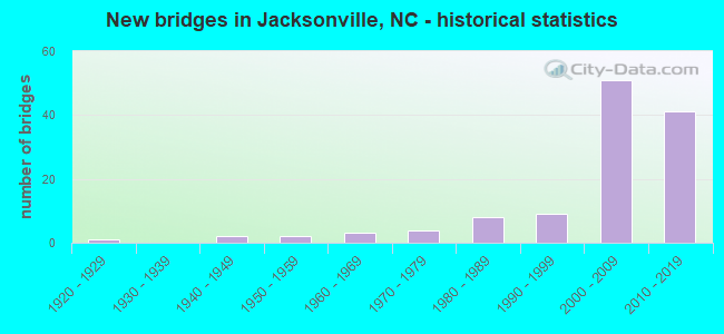
- New bridges - historical statistics
- 11920-1929
- 21940-1949
- 21950-1959
- 31960-1969
- 41970-1979
- 81980-1989
- 91990-1999
- 512000-2009
- 412010-2019


- Bridge Condition - Deck
- 6.8%Very good
- 68.9%Good
- 17.6%Satisfactory
- 6.8%Fair

- Bridge Condition - Superstructure
- 41.9%Very good
- 43.2%Good
- 9.5%Satisfactory
- 4.1%Fair
- 1.4%Poor

- Bridge Condition - Substructure
- 1.4%Excellent
- 13.5%Very good
- 58.1%Good
- 20.3%Satisfactory
- 4.1%Fair
- 1.4%Poor
- 1.4%Critical

- Bridge Condition - Channel
- 10.6%Very good
- 66.0%Good
- 10.6%Satisfactory
- 12.8%Fair

- Bridge Condition - Culverts
- 11.1%Good
- 44.4%Satisfactory
- 44.4%Fair
Find on map >> Show street view
Structure Number: 1330308, Location: .1M.N.OF WILSON GATE ENTR (Lat: 34.744556, Lng: -77.390333), Route carried "on" structure: City street , Year Built: 2014, Status: Open, Structure Length: 4.51m (14.80ft), Average Daily Traffic: 35,000 (year 2018), Truck Traffic: 7%, Average Future Daily Traffic: 70,000 (year 2040), Design Load: HL 93, Features Intersected: NC24, Facility Carried by Structure: BASE ENTRY RD
Minimum Vertical Clearance: 30+ m (98+ ft), Kilometerpoint: 0.000, Lanes on structure: 4, Lanes under structure: 7, Owner: State Highway Agency, Approaching Roadway Width: 20.4m (66.9ft), Material/Design: Prestressed concrete continuous, Design/Construction: Stringer/Multi-beam, Number Of Spans In Main Unit: 2, Length of Maximum Span: 23.4m (76.8ft), Curb-To-Curb Width: 20.4m (66.9ft), Out-to-Out Width: 21.7m (71.2ft)
Condition: Deck: Good, Superstructure: Good, Substructure: Very good, Operating Rating: 83.4 metric tons, Method Used To Determine Operating Rating: Load and Resistance Factor (LRFR), Inventory Rating: 50.8 metric tons, Method Used To Determine Inventory Rating: Load and Resistance Factor (LRFR), Structural Evaluation: Better than present minimum criteria, Deck Geometry: Superior to present desirable criteria, Underclear: Somewhat better than minimum adequacy, Approach Roadway Alignment: Equal to present desirable criteria, Designated Inspection Frequency: Every 24 months, Inspection Date: May 2020, Deck Structure Type: Concrete Cast-file-Place, Wearing Surface/Protective System: Wearing Surface: Monolithic Concrete, Membrane: Built-up, Deck Protection: Epoxy Coated Reinforcing
Find on map >> Show street view
Structure Number: 133031, Location: .3 MILES EAST OF SR 1403 (Lat: 34.774106, Lng: -77.361133), Route carried "on" structure: State highway 1406, Year Built: 2017, Status: Open, Structure Length: 9.32m (30.58ft), Average Daily Traffic: 12,000 (year 2012), Truck Traffic: 6%, Average Future Daily Traffic: 24,000 (year 2040), Design Load: HL 93, Features Intersected: NORTHEAST CREEK
Minimum Vertical Clearance: 30+ m (98+ ft), Kilometerpoint: 0.000, Lanes on structure: 2, Owner: State Highway Agency, Approaching Roadway Width: 8.8m (28.9ft), Material/Design: Prestressed concrete, Design/Construction: Slab, Number Of Spans In Main Unit: 6, Number Of Approach Spans: 2, Length of Maximum Span: 16.4m (53.8ft), Curb or Sidewalk Widths: Left: 0.0m, Right: 1.8m (5.9ft), Curb-To-Curb Width: 9.1m (29.9ft), Out-to-Out Width: 11.8m (38.7ft)
Condition: Deck: Very good, Superstructure: Very good, Substructure: Excellent, Channel: Good, Operating Rating: 53.5 metric tons, Method Used To Determine Operating Rating: Load and Resistance Factor (LRFR), Inventory Rating: 40.8 metric tons, Method Used To Determine Inventory Rating: Load and Resistance Factor (LRFR), Structural Evaluation: Equal to present desirable criteria, Deck Geometry: Meets minimum limits, Waterway Adequacy: Better than present minimum criteria, Approach Roadway Alignment: Equal to present desirable criteria, Designated Inspection Frequency: Every 24 months, Inspection Date: March 2020, Deck Structure Type: Concrete Precast Panels, Wearing Surface/Protective System: Wearing Surface: Monolithic Concrete, Deck Protection: Epoxy Coated Reinforcing
Find on map >> Show street view
Structure Number: 1330311, Location: 0.3 MI SOUTH OF SR1465 (Lat: 34.748000, Lng: -77.329208), Route carried "on" structure: State highway 1406, Year Built: 2015, Status: Open, Structure Length: 3.81m (12.50ft), Average Daily Traffic: 9,000 (year 2018), Truck Traffic: 6%, Average Future Daily Traffic: 18,000 (year 2040), Design Load: HL 93, Features Intersected: LITTLE NE CREEK
Minimum Vertical Clearance: 30+ m (98+ ft), Kilometerpoint: 0.000, Lanes on structure: 2, Owner: State Highway Agency, Approaching Roadway Width: 9.1m (29.9ft), Material/Design: Prestressed concrete, Design/Construction: Slab, Number Of Spans In Main Unit: 3, Number Of Approach Spans: 2, Length of Maximum Span: 14.9m (48.9ft), Curb or Sidewalk Widths: Left: 1.8m (5.9ft), Right: 0.0m, Curb-To-Curb Width: 9.1m (29.9ft), Out-to-Out Width: 11.8m (38.7ft)
Condition: Deck: Good, Superstructure: Good, Substructure: Very good, Channel: Good, Operating Rating: 52.6 metric tons, Method Used To Determine Operating Rating: Load and Resistance Factor (LRFR), Inventory Rating: 40.8 metric tons, Method Used To Determine Inventory Rating: Load and Resistance Factor (LRFR), Structural Evaluation: Better than present minimum criteria, Deck Geometry: Meets minimum limits, Waterway Adequacy: Better than present minimum criteria, Approach Roadway Alignment: Equal to present desirable criteria, Designated Inspection Frequency: Every 24 months, Underwater Inspection Frequency: Every 60 months, Inspection Date: March 2021, Underwater Inspection Date: April 2021, Deck Structure Type: Concrete Precast Panels, Wearing Surface/Protective System: Wearing Surface: Monolithic Concrete, Deck Protection: Epoxy Coated Reinforcing
Find on map >> Show street view
Structure Number: 133002, Location: 1.6 MI. N. JCT. SR1406 (Lat: 34.727661, Lng: -77.343836), Route carried "under" structure: State highway 24, Year Built: 1974, Structure Length: 0. m, Average Daily Traffic: 16,500 (year 2018), Truck Traffic: 12%, Features Intersected: HOLCOMB BOULEVARD
Minimum Vertical Clearance: 5.71m (18.73ft), Kilometerpoint: 0.000, Lanes on structure: 4, Lanes under structure: 2, Material/Design: Steel continuous, Design/Construction: Stringer/Multi-beam, Length of Maximum Span: 36.2m (118.8ft)
Find on map >> Show street view
Structure Number: 133002, Location: 1.6 MI. N. JCT. SR1406 (Lat: 34.727661, Lng: -77.343836), Route carried "under" structure: State highway 24, Year Built: 1974, Structure Length: 0. m, Average Daily Traffic: 16,500 (year 2018), Truck Traffic: 12%, Features Intersected: HOLCOMB BOULEVARD
Minimum Vertical Clearance: 5.08m (16.67ft), Kilometerpoint: 0.000, Lanes on structure: 4, Lanes under structure: 3, Material/Design: Steel continuous, Design/Construction: Stringer/Multi-beam, Length of Maximum Span: 36.2m (118.8ft)
Find on map >> Show street view
Structure Number: 1330254, Location: 1.6 MI. S. JCT. NC24 (Lat: 34.732175, Lng: -77.421697), Route carried "under" structure: ServiceFederal lands road , Year Built: 2001, Structure Length: 0. m, Average Daily Traffic: 100 (year 2010), Truck Traffic: 6%, Features Intersected: US17S,NC24E,NC53E, Facility Carried by Structure: MILITARY TRAIL
Minimum Vertical Clearance: 5.76m (18.90ft), Kilometerpoint: 0.000, Lanes on structure: 3, Lanes under structure: 2, Material/Design: Steel, Design/Construction: Stringer/Multi-beam, Length of Maximum Span: 34.4m (112.9ft)
Find on map >> Show street view
Structure Number: 1330255, Location: 1.6 MI. S. JCT. NC24 (Lat: 34.731953, Lng: -77.421533), Route carried "under" structure: ServiceFederal lands road , Year Built: 2001, Structure Length: 0. m, Average Daily Traffic: 100 (year 2010), Truck Traffic: 7%, Features Intersected: US17N,NC24E,NC53E, Facility Carried by Structure: MILITARY TRAIL
Minimum Vertical Clearance: 5.81m (19.06ft), Kilometerpoint: 0.000, Lanes on structure: 3, Lanes under structure: 2, Material/Design: Steel, Design/Construction: Stringer/Multi-beam, Length of Maximum Span: 35.9m (117.8ft)
Find on map >> Show street view
Structure Number: 1330256, Location: 0.8 MI. S. JCT. NC24 (Lat: 34.737981, Lng: -77.416858), Route carried "under" structure: ServiceOther road , Year Built: 2001, Structure Length: 0. m, Average Daily Traffic: 50 (year 2003), Features Intersected: US17S, Facility Carried by Structure: MILITARY TRAIL
Minimum Vertical Clearance: 5.77m (18.93ft), Kilometerpoint: 0.000, Lanes on structure: 3, Lanes under structure: 2, Material/Design: Steel, Design/Construction: Stringer/Multi-beam, Length of Maximum Span: 34.1m (111.9ft)
Find on map >> Show street view
Structure Number: 1330257, Location: 0.8MI. S. OF NC24 (Lat: 34.737922, Lng: -77.416556), Route carried "under" structure: Other road , Year Built: 2001, Structure Length: 0. m, Average Daily Traffic: 50 (year 2003), Truck Traffic: 6%, Features Intersected: US17N, Facility Carried by Structure: MILITARY TRAIL E&W
Minimum Vertical Clearance: 5.79m (19.00ft), Kilometerpoint: 0.000, Lanes on structure: 3, Lanes under structure: 2, Material/Design: Steel, Design/Construction: Stringer/Multi-beam, Length of Maximum Span: 34.1m (111.9ft)
Find on map >> Show street view
Structure Number: 1330258, Location: 0.7 MI.S. OF NC24 (Lat: 34.743383, Lng: -77.413067), Route carried "under" structure: Bypass US 17, Year Built: 2001, Structure Length: 0. m, Average Daily Traffic: 18,000 (year 2016), Truck Traffic: 12%, Features Intersected: MONTFORD POINT RD.
Minimum Vertical Clearance: 5.68m (18.64ft), Kilometerpoint: 33.071, Lanes on structure: 3, Lanes under structure: 4, Material/Design: Prestressed concrete continuous, Design/Construction: Stringer/Multi-beam, Length of Maximum Span: 28.0m (91.9ft)
Find on map >> Show street view
Structure Number: 1330258, Location: 0.7 MI.S. OF NC24 (Lat: 34.743383, Lng: -77.413067), Route carried "under" structure: Bypass US 17, Year Built: 2001, Structure Length: 0. m, Average Daily Traffic: 18,000 (year 2016), Truck Traffic: 12%, Features Intersected: MONTFORD POINT RD.
Minimum Vertical Clearance: 6.04m (19.82ft), Kilometerpoint: 33.071, Lanes on structure: 3, Lanes under structure: 4, Material/Design: Prestressed concrete continuous, Design/Construction: Stringer/Multi-beam, Length of Maximum Span: 28.0m (91.9ft)
Find on map >> Show street view
Structure Number: 1330259, Location: 0.5MI.W. OF NC24 (Lat: 34.745903, Lng: -77.404617), Route carried "under" structure: Ramp State highway 24, Year Built: 2001, Structure Length: 0. m, Average Daily Traffic: 15,750 (year 2018), Truck Traffic: 12%, Features Intersected: US17W BYP. CONN.
Minimum Vertical Clearance: 5.17m (16.96ft), Kilometerpoint: 0.000, Lanes on structure: 2, Lanes under structure: 3, Material/Design: Steel, Design/Construction: Stringer/Multi-beam, Length of Maximum Span: 41.7m (136.8ft)
Find on map >> Show street view
Structure Number: 133026, Location: 0.3MI.S. NC24 (Lat: 34.745856, Lng: -77.409211), Route carried "under" structure: Ramp US 17, Year Built: 2001, Structure Length: 0. m, Average Daily Traffic: 15,750 (year 2018), Truck Traffic: 12%, Features Intersected: US17 NBL
Minimum Vertical Clearance: 5.50m (18.04ft), Kilometerpoint: 0.000, Lanes on structure: 2, Lanes under structure: 2, Material/Design: Steel, Design/Construction: Stringer/Multi-beam, Length of Maximum Span: 29.2m (95.8ft)
Find on map >> Show street view
Structure Number: 1330262, Location: 0.5 MI. E. JCT. NC53 (Lat: 34.745058, Lng: -77.456958), Route carried "under" structure: Business US 17, Year Built: 2006, Structure Length: 0. m, Average Daily Traffic: 9,000 (year 2018), Truck Traffic: 12%, Features Intersected: NC24W,NC53W
Minimum Vertical Clearance: 5.28m (17.32ft), Kilometerpoint: 32.034, Lanes on structure: 3, Lanes under structure: 2, Material/Design: Steel continuous, Design/Construction: Stringer/Multi-beam, Length of Maximum Span: 39.9m (130.9ft)
Find on map >> Show street view
Structure Number: 1330262, Location: 0.5 MI. E. JCT. NC53 (Lat: 34.745058, Lng: -77.456958), Route carried "under" structure: Business US 17, Year Built: 2006, Structure Length: 0. m, Average Daily Traffic: 9,000 (year 2018), Truck Traffic: 12%, Features Intersected: NC24W,NC53W
Minimum Vertical Clearance: 5.61m (18.41ft), Kilometerpoint: 32.034, Lanes on structure: 3, Lanes under structure: 3, Material/Design: Steel continuous, Design/Construction: Stringer/Multi-beam, Length of Maximum Span: 39.9m (130.9ft)
Find on map >> Show street view
Structure Number: 1330263, Location: 0.5 MI. EAST JCT. NC53 (Lat: 34.744808, Lng: -77.457081), Route carried "under" structure: Bypass US 17, Year Built: 2006, Structure Length: 0. m, Average Daily Traffic: 9,000 (year 2018), Truck Traffic: 12%, Features Intersected: NC24EBL
Minimum Vertical Clearance: 5.20m (17.06ft), Kilometerpoint: 0.000, Lanes on structure: 3, Lanes under structure: 2, Material/Design: Steel continuous, Design/Construction: Stringer/Multi-beam, Length of Maximum Span: 41.7m (136.8ft)
Find on map >> Show street view
Structure Number: 1330263, Location: 0.5 MI. EAST JCT. NC53 (Lat: 34.744808, Lng: -77.457081), Route carried "under" structure: Bypass US 17, Year Built: 2006, Structure Length: 0. m, Average Daily Traffic: 9,000 (year 2018), Truck Traffic: 12%, Features Intersected: NC24EBL
Minimum Vertical Clearance: 5.94m (19.49ft), Kilometerpoint: 32.034, Lanes on structure: 3, Lanes under structure: 3, Material/Design: Steel continuous, Design/Construction: Stringer/Multi-beam, Length of Maximum Span: 41.7m (136.8ft)
Find on map >> Show street view
Structure Number: 1330265, Location: 1.0 MI. N. JCT. SR1130 (Lat: 34.740919, Lng: -77.459069), Route carried "under" structure: Ramp US 17, Year Built: 2005, Structure Length: 0. m, Average Daily Traffic: 19,000 (year 2018), Truck Traffic: 12%, Features Intersected: US17N
Minimum Vertical Clearance: 5.46m (17.91ft), Kilometerpoint: 0.000, Lanes on structure: 2, Lanes under structure: 2, Material/Design: Steel continuous, Design/Construction: Stringer/Multi-beam, Length of Maximum Span: 32.6m (107.0ft)
Find on map >> Show street view
Structure Number: 1330266, Location: 0.5 MI. E. JCT. NC258 (Lat: 34.741078, Lng: -77.453236), Route carried "under" structure: US 17, Year Built: 2001, Structure Length: 0. m, Average Daily Traffic: 9,500 (year 2016), Truck Traffic: 12%, Features Intersected: NC24E,NC53E
Minimum Vertical Clearance: 5.39m (17.68ft), Kilometerpoint: 0.000, Lanes on structure: 2, Lanes under structure: 2, Material/Design: Steel, Design/Construction: Stringer/Multi-beam, Length of Maximum Span: 44.1m (144.7ft)
Find on map >> Show street view
Structure Number: 1330267, Location: 0.5 MI. W. JCT. CURTIS RD (Lat: 34.734475, Lng: -77.446425), Route carried "under" structure: Bypass US 17, Year Built: 2001, Structure Length: 0. m, Average Daily Traffic: 22,500 (year 2018), Truck Traffic: 12%, Features Intersected: BEACH RD.
Minimum Vertical Clearance: 5.99m (19.65ft), Kilometerpoint: 32.309, Lanes on structure: 2, Lanes under structure: 3, Material/Design: Steel continuous, Design/Construction: Stringer/Multi-beam, Length of Maximum Span: 36.8m (120.7ft)
Find on map >> Show street view
Structure Number: 1330267, Location: 0.5 MI. W. JCT. CURTIS RD (Lat: 34.734475, Lng: -77.446425), Route carried "under" structure: Bypass US 17, Year Built: 2001, Structure Length: 0. m, Average Daily Traffic: 22,500 (year 2018), Truck Traffic: 12%, Features Intersected: BEACH RD.
Minimum Vertical Clearance: 5.89m (19.32ft), Kilometerpoint: 32.309, Lanes on structure: 2, Lanes under structure: 3, Material/Design: Steel continuous, Design/Construction: Stringer/Multi-beam, Length of Maximum Span: 36.8m (120.7ft)
Find on map >> Show street view
Structure Number: 1330275, Location: JCT. NC24 & US17 BYP (Lat: 34.747264, Lng: -77.409025), Route carried "under" structure: State highway 24, Year Built: 2006, Structure Length: 0. m, Average Daily Traffic: 7,250 (year 2018), Truck Traffic: 12%, Features Intersected: US17S
Minimum Vertical Clearance: 5.38m (17.65ft), Kilometerpoint: 0.000, Lanes on structure: 2, Lanes under structure: 3, Material/Design: Steel continuous, Design/Construction: Stringer/Multi-beam, Length of Maximum Span: 36.2m (118.8ft)
Find on map >> Show street view
Structure Number: 1330275, Location: JCT. NC24 & US17 BYP (Lat: 34.747264, Lng: -77.409025), Route carried "under" structure: State highway 24, Year Built: 2006, Structure Length: 0. m, Average Daily Traffic: 7,250 (year 2018), Truck Traffic: 12%, Features Intersected: US17S
Minimum Vertical Clearance: 5.30m (17.39ft), Kilometerpoint: 0.000, Lanes on structure: 2, Lanes under structure: 3, Material/Design: Steel continuous, Design/Construction: Stringer/Multi-beam, Length of Maximum Span: 36.2m (118.8ft)
Find on map >> Show street view
Structure Number: 1330276, Location: JCT. NC24 & US17BYP (Lat: 34.747094, Lng: -77.407944), Route carried "under" structure: State highway 24, Year Built: 2006, Structure Length: 0. m, Average Daily Traffic: 7,250 (year 2018), Truck Traffic: 12%, Features Intersected: US17N,BYP.
Minimum Vertical Clearance: 7.23m (23.72ft), Kilometerpoint: 0.000, Lanes on structure: 2, Lanes under structure: 5, Material/Design: Steel continuous, Design/Construction: Stringer/Multi-beam, Length of Maximum Span: 41.7m (136.8ft)
Find on map >> Show street view
Structure Number: 1330276, Location: JCT. NC24 & US17BYP (Lat: 34.747094, Lng: -77.407944), Route carried "under" structure: State highway 24, Year Built: 2006, Structure Length: 0. m, Average Daily Traffic: 7,250 (year 2018), Truck Traffic: 12%, Features Intersected: US17N,BYP.
Minimum Vertical Clearance: 7.23m (23.72ft), Kilometerpoint: 0.000, Lanes on structure: 2, Lanes under structure: 3, Material/Design: Steel continuous, Design/Construction: Stringer/Multi-beam, Length of Maximum Span: 41.7m (136.8ft)
Find on map >> Show street view
Structure Number: 1330277, Location: 1 MILE NORTH OF NC24 (Lat: 34.754800, Lng: -77.395483), Route carried "under" structure: State highway 1308, Year Built: 2006, Structure Length: 0. m, Average Daily Traffic: 12,500 (year 2018), Truck Traffic: 6%, Features Intersected: US17 SBL.
Minimum Vertical Clearance: 5.68m (18.64ft), Kilometerpoint: 0.000, Lanes on structure: 2, Lanes under structure: 4, Material/Design: Steel, Design/Construction: Stringer/Multi-beam, Length of Maximum Span: 53.0m (173.9ft)
Find on map >> Show street view
Structure Number: 1330278, Location: 1 MILE NORTH OF NC24 (Lat: 34.754672, Lng: -77.395306), Route carried "under" structure: State highway 1308, Year Built: 2006, Structure Length: 0. m, Average Daily Traffic: 12,500 (year 2018), Truck Traffic: 6%, Features Intersected: US17N.
Minimum Vertical Clearance: 6.06m (19.88ft), Kilometerpoint: 0.000, Lanes on structure: 2, Lanes under structure: 4, Material/Design: Steel, Design/Construction: Stringer/Multi-beam, Length of Maximum Span: 55.1m (180.8ft)
Find on map >> Show street view
Structure Number: 1330279, Location: 0.5 MI. S. JCT. US17 (Lat: 34.768389, Lng: -77.396436), Route carried "under" structure: State highway 1403, Year Built: 2006, Structure Length: 0. m, Average Daily Traffic: 9,300 (year 2016), Truck Traffic: 6%, Features Intersected: US17S
Minimum Vertical Clearance: 6.18m (20.28ft), Kilometerpoint: 0.000, Lanes on structure: 2, Lanes under structure: 3, Material/Design: Steel, Design/Construction: Stringer/Multi-beam, Length of Maximum Span: 56.3m (184.7ft)
Find on map >> Show street view
Structure Number: 133028, Location: 0.5 MILES SOUTH OF US17 (Lat: 34.768533, Lng: -77.396231), Route carried "under" structure: State highway 1403, Year Built: 2006, Structure Length: 0. m, Average Daily Traffic: 7,100 (year 2018), Truck Traffic: 6%, Features Intersected: US17N.BYP
Minimum Vertical Clearance: 6.06m (19.88ft), Kilometerpoint: 0.000, Lanes on structure: 2, Lanes under structure: 3, Material/Design: Steel, Design/Construction: Stringer/Multi-beam, Length of Maximum Span: 52.1m (170.9ft)
Find on map >> Show street view
Structure Number: 1330289, Location: 0.1 MI. E. JCT. SR1308 (Lat: 34.761500, Lng: -77.396833), Route carried "under" structure: US 17, Year Built: 2013, Structure Length: 0. m, Average Daily Traffic: 7,500 (year 2018), Truck Traffic: 12%, Features Intersected: SR2614
Minimum Vertical Clearance: 5.41m (17.75ft), Kilometerpoint: 33.528, Lanes on structure: 4, Lanes under structure: 3, Material/Design: Prestressed concrete continuous, Design/Construction: Stringer/Multi-beam, Length of Maximum Span: 32.6m (107.0ft)
Find on map >> Show street view
Structure Number: 1330289, Location: 0.1 MI. E. JCT. SR1308 (Lat: 34.761500, Lng: -77.396833), Route carried "under" structure: US 17, Year Built: 2013, Structure Length: 0. m, Average Daily Traffic: 7,500 (year 2018), Truck Traffic: 12%, Features Intersected: SR2614
Minimum Vertical Clearance: 5.18m (16.99ft), Kilometerpoint: 33.528, Lanes on structure: 4, Lanes under structure: 3, Material/Design: Prestressed concrete continuous, Design/Construction: Stringer/Multi-beam, Length of Maximum Span: 32.6m (107.0ft)
Find on map >> Show street view
Structure Number: 133029, Location: 1.8 MI. N. JCT. NC24 (Lat: 34.768367, Lng: -77.396767), Route carried "under" structure: State highway 1403, Year Built: 2013, Structure Length: 0. m, Average Daily Traffic: 9,300 (year 2018), Truck Traffic: 6%, Features Intersected: US17S.RAMP
Minimum Vertical Clearance: 5.96m (19.55ft), Kilometerpoint: 0.000, Lanes on structure: 2, Lanes under structure: 3, Material/Design: Steel, Design/Construction: Stringer/Multi-beam, Length of Maximum Span: 56.0m (183.7ft)
Find on map >> Show street view
Structure Number: 1330291, Location: 1.9 MI. N. JCT. NC24 (Lat: 34.768767, Lng: -77.395983), Route carried "under" structure: State highway 1403, Year Built: 2013, Structure Length: 0. m, Average Daily Traffic: 12,000 (year 2018), Truck Traffic: 6%, Features Intersected: US17N.RAMP
Minimum Vertical Clearance: 6.22m (20.41ft), Kilometerpoint: 0.000, Lanes on structure: 2, Lanes under structure: 3, Material/Design: Steel, Design/Construction: Stringer/Multi-beam, Length of Maximum Span: 48.4m (158.8ft)
Find on map >> Show street view
Structure Number: 1330292, Location: 2.1 MI. N OF NC24 (Lat: 34.772517, Lng: -77.396867), Route carried "under" structure: Bypass US 17, Year Built: 2013, Structure Length: 0. m, Average Daily Traffic: 11,500 (year 2018), Truck Traffic: 12%, Features Intersected: US17 BYPASS RAMP
Minimum Vertical Clearance: 5.81m (19.06ft), Kilometerpoint: 33.528, Lanes on structure: 2, Lanes under structure: 2, Material/Design: Steel continuous, Design/Construction: Stringer/Multi-beam, Length of Maximum Span: 48.1m (157.8ft)
Find on map >> Show street view
Structure Number: 1330292, Location: 2.1 MI. N OF NC24 (Lat: 34.772517, Lng: -77.396867), Route carried "under" structure: Bypass US 17, Year Built: 2013, Structure Length: 0. m, Average Daily Traffic: 11,500 (year 2018), Truck Traffic: 12%, Features Intersected: US17 BYPASS RAMP
Minimum Vertical Clearance: 5.94m (19.49ft), Kilometerpoint: 33.528, Lanes on structure: 2, Lanes under structure: 2, Material/Design: Steel continuous, Design/Construction: Stringer/Multi-beam, Length of Maximum Span: 48.1m (157.8ft)
Find on map >> Show street view
Structure Number: 1330293, Location: 2 MI. S. JCT. SR1470 (Lat: 34.773267, Lng: -77.398400), Route carried "under" structure: Business US 17, Year Built: 2013, Structure Length: 0. m, Average Daily Traffic: 11,500 (year 2018), Truck Traffic: 12%, Features Intersected: US17 RAMP SBL
Minimum Vertical Clearance: 5.35m (17.55ft), Kilometerpoint: 33.833, Lanes on structure: 3, Lanes under structure: 2, Material/Design: Steel, Design/Construction: Stringer/Multi-beam, Length of Maximum Span: 37.7m (123.7ft)
Find on map >> Show street view
Structure Number: 1330293, Location: 2 MI. S. JCT. SR1470 (Lat: 34.773267, Lng: -77.398400), Route carried "under" structure: Business US 17, Year Built: 2013, Structure Length: 0. m, Average Daily Traffic: 11,500 (year 2018), Truck Traffic: 12%, Features Intersected: US17 RAMP SBL
Minimum Vertical Clearance: 5.61m (18.41ft), Kilometerpoint: 33.833, Lanes on structure: 3, Lanes under structure: 2, Material/Design: Steel, Design/Construction: Stringer/Multi-beam, Length of Maximum Span: 37.7m (123.7ft)
Find on map >> Show street view
Structure Number: 1330294, Location: 2.0MI. S. JCT. SR1470 (Lat: 34.773717, Lng: -77.397950), Route carried "under" structure: Business US 17, Year Built: 2013, Structure Length: 0. m, Average Daily Traffic: 11,500 (year 2018), Truck Traffic: 12%, Features Intersected: US17 RAMP NBL
Minimum Vertical Clearance: 5.08m (16.67ft), Kilometerpoint: 33.833, Lanes on structure: 2, Lanes under structure: 2, Material/Design: Steel continuous, Design/Construction: Stringer/Multi-beam, Length of Maximum Span: 39.3m (128.9ft)
Find on map >> Show street view
Structure Number: 1330294, Location: 2.0MI. S. JCT. SR1470 (Lat: 34.773717, Lng: -77.397950), Route carried "under" structure: Business US 17, Year Built: 2013, Structure Length: 0. m, Average Daily Traffic: 11,500 (year 2018), Truck Traffic: 12%, Features Intersected: US17 RAMP NBL
Minimum Vertical Clearance: 5.56m (18.24ft), Kilometerpoint: 33.833, Lanes on structure: 2, Lanes under structure: 3, Material/Design: Steel continuous, Design/Construction: Stringer/Multi-beam, Length of Maximum Span: 39.3m (128.9ft)
Find on map >> Show street view
Structure Number: 1330308, Location: .1M.N.OF WILSON GATE ENTR (Lat: 34.744556, Lng: -77.390333), Route carried "under" structure: State highway 24, Year Built: 2014, Structure Length: 0. m, Average Daily Traffic: 20,000 (year 2018), Truck Traffic: 12%, Features Intersected: BASE ENTRY RD
Minimum Vertical Clearance: 5.33m (17.49ft), Kilometerpoint: 0.000, Lanes on structure: 4, Lanes under structure: 3, Material/Design: Prestressed concrete continuous, Design/Construction: Stringer/Multi-beam, Length of Maximum Span: 23.4m (76.8ft)
Find on map >> Show street view
Structure Number: 1330308, Location: .1M.N.OF WILSON GATE ENTR (Lat: 34.744556, Lng: -77.390333), Route carried "under" structure: State highway 24, Year Built: 2014, Structure Length: 0. m, Average Daily Traffic: 20,000 (year 2018), Truck Traffic: 12%, Features Intersected: BASE ENTRY RD
Minimum Vertical Clearance: 5.08m (16.67ft), Kilometerpoint: 0.000, Lanes on structure: 4, Lanes under structure: 4, Material/Design: Prestressed concrete continuous, Design/Construction: Stringer/Multi-beam, Length of Maximum Span: 23.4m (76.8ft)