Bridge Statistics for King of Prussia, Pennsylvania (PA)
Condition, Traffic, Stress, Structural Evaluation, Project Costs
- National Bridge Inventory (NBI) Statistics
- 132Number of bridges
- 784ft / 239mTotal length
- $9,914,000Total costs
- 3,337,138Total average daily traffic
- 240,512Total average daily truck traffic
- National Bridge Inventory (NBI) Registered Bridges for King of Prussia
- No street view available for this location
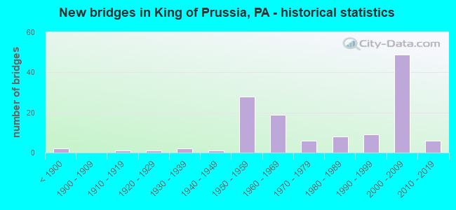
- New bridges - historical statistics
- 2Before 1900
- 11910-1919
- 11920-1929
- 21930-1939
- 11940-1949
- 281950-1959
- 191960-1969
- 61970-1979
- 81980-1989
- 91990-1999
- 492000-2009
- 62010-2019

- Reconstructed bridges - Historical Statistics
- 11930-1939
- 01940-1949
- 01950-1959
- 11960-1969
- 01970-1979
- 21980-1989
- 61990-1999
- 22000-2009
- 12010-2019


- Bridge Condition - Deck
- 7.7%Very good
- 55.8%Good
- 13.5%Satisfactory
- 17.3%Fair
- 3.8%Poor
- 1.9%Serious

- Bridge Condition - Superstructure
- 20.4%Very good
- 35.2%Good
- 22.2%Satisfactory
- 14.8%Fair
- 7.4%Poor

- Bridge Condition - Substructure
- 3.7%Very good
- 42.6%Good
- 25.9%Satisfactory
- 22.2%Fair
- 5.6%Poor

- Bridge Condition - Channel
- 3.6%Very good
- 14.3%Good
- 17.9%Satisfactory
- 42.9%Fair
- 21.4%Poor

- Bridge Condition - Culverts
- 36.4%Good
- 27.3%Satisfactory
- 27.3%Fair
- 9.1%Critical
Find on map >> Show street view
Structure Number: 28301, Location: U. MER. TWP. 27J12/3366D5 (Lat: 40.091111, Lng: -75.415833), Route carried "on" structure: Ramp State highway , Year Built: 1965, Status: Open, Structure Length: 6.31m (20.70ft), Average Daily Traffic: 8,609 (year 2022), Truck Traffic: 7%, Average Future Daily Traffic: 7,227 (year 2032), Design Load: HS 20, Features Intersected: 422-COUNTY LINE EXPRESS, Facility Carried by Structure: 422 - RAMPS K & L
Minimum Vertical Clearance: 30+ m (98+ ft), Kilometerpoint: 0.000, Lanes on structure: 2, Lanes under structure: 4, Base Highway Network: Yes, Owner: State Highway Agency, Approaching Roadway Width: 21.9m (71.9ft), Skew: 30 degrees, Material/Design: Prestressed concrete, Design/Construction: Stringer/Multi-beam, Number Of Spans In Main Unit: 4, Length of Maximum Span: 20.7m (67.9ft), Curb or Sidewalk Widths: Left: 0.2m (0.7ft), Right: 0.2m (0.7ft), Curb-To-Curb Width: 19.8m (65.0ft), Out-to-Out Width: 22.6m (74.1ft)
Condition: Deck: Fair, Superstructure: Poor, Substructure: Satisfactory, Operating Rating: 74.4 metric tons, Method Used To Determine Operating Rating: Load Factor (LF), Inventory Rating: 30.8 metric tons, Method Used To Determine Inventory Rating: Load Factor (LF), Structural Evaluation: Meets minimum limits, Deck Geometry: Superior to present desirable criteria, Underclear: High priority of corrective action, Approach Roadway Alignment: Better than present minimum criteria, Length Of Structure Improvement: 7.00m (22.97ft), Designated Inspection Frequency: Every 24 months, Inspection Date: November 2020, Bridge Improvement Cost: $37,000, Roadway Improvement Cost: $109,000, Total Project Cost: $501,000, Deck Structure Type: Concrete Cast-file-Place, Wearing Surface/Protective System: Wearing Surface: Monolithic Concrete
Find on map >> Show street view
Structure Number: 41218, Location: S. VALLEY FORGE 24K2 (Lat: 40.077475, Lng: -75.411292), Route carried "on" structure: State highway , Year Built: 2001, Status: Open, Structure Length: 10.09m (33.10ft), Average Daily Traffic: 10,183 (year 2021), Truck Traffic: 3%, Average Future Daily Traffic: 14,152 (year 2032), Design Load: HS 25 or greater, Features Intersected: US-202,RMPS L & BC-2, Facility Carried by Structure: OLD EAGLE SCHOL RD
Minimum Vertical Clearance: 30+ m (98+ ft), Kilometerpoint: 3.203, Lanes on structure: 3, Lanes under structure: 8, Owner: State Highway Agency, Approaching Roadway Width: 13.4m (44.0ft), Material/Design: Steel continuous, Design/Construction: Stringer/Multi-beam, Number Of Spans In Main Unit: 2, Length of Maximum Span: 54.6m (179.1ft), Curb or Sidewalk Widths: Left: 0.2m (0.7ft), Right: 1.4m (4.6ft), Curb-To-Curb Width: 13.4m (44.0ft), Out-to-Out Width: 16.1m (52.8ft)
Condition: Deck: Good, Superstructure: Good, Substructure: Good, Operating Rating: 55.3 metric tons, Method Used To Determine Operating Rating: Load Factor (LF), Inventory Rating: 32.7 metric tons, Method Used To Determine Inventory Rating: Load Factor (LF), Structural Evaluation: Better than present minimum criteria, Deck Geometry: Somewhat better than minimum adequacy, Underclear: Meets minimum limits, Approach Roadway Alignment: Better than present minimum criteria, Length Of Structure Improvement: 11.00m (36.09ft), Designated Inspection Frequency: Every 24 months, Inspection Date: December 2019, Deck Structure Type: Concrete Cast-file-Place, Wearing Surface/Protective System: Wearing Surface: Monolithic Concrete, Deck Protection: Epoxy Coated Reinforcing
Find on map >> Show street view
Structure Number: 41219, Location: K OF PRUSSIA 34B1/3366G7 (Lat: 40.084078, Lng: -75.392997), Route carried "on" structure: Ramp State highway , Year Built: 2002, Status: Open, Structure Length: 7.71m (25.30ft), Average Daily Traffic: 22,553 (year 2022), Truck Traffic: 10%, Average Future Daily Traffic: 708 (year 2032), Design Load: HS 25 or greater, Features Intersected: SCHUYLKILL EXPWY, RAMP D, Facility Carried by Structure: RAMP B
Minimum Vertical Clearance: 30+ m (98+ ft), Kilometerpoint: 0.000, Lanes on structure: 2, Lanes under structure: 8, Owner: State Highway Agency, Approaching Roadway Width: 12.2m (40.0ft), Skew: 3 degrees, Material/Design: Steel continuous, Design/Construction: Stringer/Multi-beam, Number Of Spans In Main Unit: 3, Length of Maximum Span: 29.0m (95.1ft), Curb or Sidewalk Widths: Left: 0.2m (0.7ft), Right: 0.2m (0.7ft), Curb-To-Curb Width: 12.1m (39.7ft), Out-to-Out Width: 13.0m (42.7ft)
Condition: Deck: Good, Superstructure: Good, Substructure: Good, Operating Rating: 88.9 metric tons, Method Used To Determine Operating Rating: Load Factor (LF), Inventory Rating: 53.5 metric tons, Method Used To Determine Inventory Rating: Load Factor (LF), Structural Evaluation: Better than present minimum criteria, Deck Geometry: Superior to present desirable criteria, Underclear: High priority of corrective action, Approach Roadway Alignment: Better than present minimum criteria, Length Of Structure Improvement: 8.80m (28.87ft), Designated Inspection Frequency: Every 24 months, Inspection Date: May 2021, Deck Structure Type: Concrete Cast-file-Place, Wearing Surface/Protective System: Wearing Surface: Monolithic Concrete, Deck Protection: Epoxy Coated Reinforcing
Find on map >> Show street view
Structure Number: 41226, Location: .5MI SE TPK.EXIT24 34B01 (Lat: 40.083139, Lng: -75.397119), Route carried "on" structure: Ramp State highway , Year Built: 2003, Status: Open, Structure Length: 4.88m (16.01ft), Average Daily Traffic: 8,435 (year 2021), Truck Traffic: 5%, Average Future Daily Traffic: 12,488 (year 2032), Design Load: HS 25 or greater, Features Intersected: RAMP 'B', Facility Carried by Structure: RAMP 'A-1'
Minimum Vertical Clearance: 30+ m (98+ ft), Kilometerpoint: 0.000, Lanes on structure: 1, Lanes under structure: 2, Base Highway Network: Yes, Owner: State Highway Agency, Approaching Roadway Width: 10.1m (33.1ft), Skew: 9 degrees, Material/Design: Steel, Design/Construction: Stringer/Multi-beam, Number Of Spans In Main Unit: 1, Length of Maximum Span: 46.6m (152.9ft), Curb or Sidewalk Widths: Left: 0.2m (0.7ft), Right: 0.2m (0.7ft), Curb-To-Curb Width: 10.0m (32.8ft), Out-to-Out Width: 10.9m (35.8ft)
Condition: Deck: Good, Superstructure: Very good, Substructure: Good, Operating Rating: 94.3 metric tons, Method Used To Determine Operating Rating: Load Factor (LF), Inventory Rating: 56.2 metric tons, Method Used To Determine Inventory Rating: Load Factor (LF), Structural Evaluation: Better than present minimum criteria, Deck Geometry: Superior to present desirable criteria, Underclear: Superior to present desirable criteria, Approach Roadway Alignment: Somewhat better than minimum adequacy, Length Of Structure Improvement: 5.80m (19.03ft), Designated Inspection Frequency: Every 24 months, Inspection Date: September 2021, Deck Structure Type: Concrete Cast-file-Place, Wearing Surface/Protective System: Wearing Surface: Bituminous, Deck Protection: Epoxy Coated Reinforcing
Find on map >> Show street view
Structure Number: 41227, Location: S.I-76/202 34A2/3366F8 (Lat: 40.079444, Lng: -75.400833), Route carried "on" structure: State highway , Year Built: 2001, Status: Open, Structure Length: 2.59m (8.50ft), Average Daily Traffic: 8,986 (year 2022), Truck Traffic: 8%, Average Future Daily Traffic: 11,299 (year 2032), Design Load: HS 25 or greater, Features Intersected: RAMPS L AND Q, Facility Carried by Structure: SOUTH WARNER ROAD
Minimum Vertical Clearance: 30+ m (98+ ft), Kilometerpoint: 0.066, Lanes on structure: 4, Lanes under structure: 4, Owner: State Highway Agency, Approaching Roadway Width: 15.8m (51.8ft), Skew: 1 degrees, Material/Design: Steel, Design/Construction: Stringer/Multi-beam, Number Of Spans In Main Unit: 1, Length of Maximum Span: 25.0m (82.0ft), Curb or Sidewalk Widths: Left: 1.5m (4.9ft), Right: 0.2m (0.7ft), Curb-To-Curb Width: 15.8m (51.8ft), Out-to-Out Width: 18.1m (59.4ft)
Condition: Deck: Good, Superstructure: Very good, Substructure: Good, Operating Rating: 76.2 metric tons, Method Used To Determine Operating Rating: Load Factor (LF), Inventory Rating: 45.4 metric tons, Method Used To Determine Inventory Rating: Load Factor (LF), Structural Evaluation: Better than present minimum criteria, Deck Geometry: Meets minimum limits, Underclear: Meets minimum limits, Approach Roadway Alignment: Equal to present desirable criteria, Length Of Structure Improvement: 3.40m (11.15ft), Designated Inspection Frequency: Every 24 months, Inspection Date: October 2019, Deck Structure Type: Concrete Cast-file-Place, Wearing Surface/Protective System: Wearing Surface: Monolithic Concrete, Deck Protection: Epoxy Coated Reinforcing
Find on map >> Show street view
Structure Number: 41228, Location: KING OF PRUSSIA 34A01 (Lat: 40.081514, Lng: -75.402733), Route carried "on" structure: State highway , Year Built: 2001, Status: Open, Structure Length: 6.58m (21.59ft), Average Daily Traffic: 8,986 (year 2022), Truck Traffic: 8%, Average Future Daily Traffic: 11,145 (year 2032), Design Load: HS 25 or greater, Features Intersected: US RTE 202;RMPS F1 AND S, Facility Carried by Structure: SOUTH WARNER ROAD
Minimum Vertical Clearance: 30+ m (98+ ft), Kilometerpoint: 0.000, Lanes on structure: 3, Lanes under structure: 8, Owner: State Highway Agency, Approaching Roadway Width: 12.2m (40.0ft), Skew: 1 degrees, Material/Design: Steel continuous, Design/Construction: Stringer/Multi-beam, Number Of Spans In Main Unit: 2, Length of Maximum Span: 35.7m (117.1ft), Curb or Sidewalk Widths: Left: 1.5m (4.9ft), Right: 0.2m (0.7ft), Curb-To-Curb Width: 12.2m (40.0ft), Out-to-Out Width: 14.4m (47.2ft)
Condition: Deck: Good, Superstructure: Very good, Substructure: Good, Operating Rating: 60.8 metric tons, Method Used To Determine Operating Rating: Load Factor (LF), Inventory Rating: 36.3 metric tons, Method Used To Determine Inventory Rating: Load Factor (LF), Structural Evaluation: Better than present minimum criteria, Deck Geometry: Meets minimum limits, Underclear: Meets minimum limits, Approach Roadway Alignment: Better than present minimum criteria, Length Of Structure Improvement: 7.60m (24.93ft), Designated Inspection Frequency: Every 24 months, Inspection Date: March 2020, Deck Structure Type: Concrete Cast-file-Place, Wearing Surface/Protective System: Wearing Surface: Monolithic Concrete, Deck Protection: Epoxy Coated Reinforcing
Find on map >> Show street view
Structure Number: 41238, Location: .2 MI NE DEVON PK 25A2 (Lat: 40.078711, Lng: -75.404758), Route carried "on" structure: Ramp State highway , Year Built: 2001, Status: Open, Structure Length: 5.46m (17.91ft), Average Daily Traffic: 5,091 (year 2022), Truck Traffic: 5%, Average Future Daily Traffic: 1,976 (year 2032), Design Load: HS 25 or greater, Features Intersected: RAMPS L,N,Q, Facility Carried by Structure: RAMP P
Minimum Vertical Clearance: 30+ m (98+ ft), Kilometerpoint: 0.000, Lanes on structure: 1, Lanes under structure: 4, Base Highway Network: Yes, Owner: State Highway Agency, Approaching Roadway Width: 10.1m (33.1ft), Skew: 4 degrees, Material/Design: Steel, Design/Construction: Stringer/Multi-beam, Number Of Spans In Main Unit: 1, Length of Maximum Span: 52.4m (171.9ft), Curb or Sidewalk Widths: Left: 0.2m (0.7ft), Right: 0.2m (0.7ft), Curb-To-Curb Width: 10.0m (32.8ft), Out-to-Out Width: 10.9m (35.8ft)
Condition: Deck: Good, Superstructure: Very good, Substructure: Good, Operating Rating: 96.2 metric tons, Method Used To Determine Operating Rating: Load Factor (LF), Inventory Rating: 57.2 metric tons, Method Used To Determine Inventory Rating: Load Factor (LF), Structural Evaluation: Better than present minimum criteria, Deck Geometry: Superior to present desirable criteria, Underclear: Meets minimum limits, Approach Roadway Alignment: Equal to present desirable criteria, Designated Inspection Frequency: Every 24 months, Inspection Date: Febuary 2021, Deck Structure Type: Concrete Cast-file-Place, Wearing Surface/Protective System: Wearing Surface: Monolithic Concrete, Deck Protection: Epoxy Coated Reinforcing
Find on map >> Show street view
Structure Number: 41239, Location: SW WARNER RD 34A2/3366F8 (Lat: 40.079011, Lng: -75.403458), Route carried "on" structure: State highway , Year Built: 2001, Status: Open, Structure Length: 13.72m (45.01ft), Average Daily Traffic: 2,856 (year 2020), Truck Traffic: 7%, Average Future Daily Traffic: 7,354 (year 2032), Design Load: HS 25 or greater, Features Intersected: RAMPS L AND Q, Facility Carried by Structure: DEVON PARK DRIVE
Minimum Vertical Clearance: 30+ m (98+ ft), Kilometerpoint: 0.000, Lanes on structure: 3, Lanes under structure: 4, Owner: State Highway Agency, Approaching Roadway Width: 14.0m (45.9ft), Skew: 9 degrees, Material/Design: Steel continuous, Design/Construction: Stringer/Multi-beam, Number Of Spans In Main Unit: 3, Length of Maximum Span: 50.3m (165.0ft), Curb or Sidewalk Widths: Left: 1.5m (4.9ft), Right: 0.2m (0.7ft), Curb-To-Curb Width: 14.0m (45.9ft), Out-to-Out Width: 16.3m (53.5ft)
Condition: Deck: Good, Superstructure: Good, Substructure: Good, Operating Rating: 80.7 metric tons, Method Used To Determine Operating Rating: Load Factor (LF), Inventory Rating: 49.0 metric tons, Method Used To Determine Inventory Rating: Load Factor (LF), Structural Evaluation: Better than present minimum criteria, Deck Geometry: Somewhat better than minimum adequacy, Underclear: Meets minimum limits, Approach Roadway Alignment: Better than present minimum criteria, Length Of Structure Improvement: 14.80m (48.56ft), Designated Inspection Frequency: Every 24 months, Inspection Date: November 2019, Deck Structure Type: Concrete Cast-file-Place, Wearing Surface/Protective System: Wearing Surface: Monolithic Concrete, Deck Protection: Epoxy Coated Reinforcing
Find on map >> Show street view
Structure Number: 41245, Location: .1MI.N.INT.DV.PK 25A2 (Lat: 40.078961, Lng: -75.405222), Route carried "on" structure: Ramp State highway , Year Built: 2001, Status: Open, Structure Length: 10.00m (32.81ft), Average Daily Traffic: 2,022 (year 2022), Truck Traffic: 5%, Average Future Daily Traffic: 7,031 (year 2032), Design Load: HS 25 or greater, Features Intersected: RAMPS L,N,Q,R,S, Facility Carried by Structure: RAMP O
Minimum Vertical Clearance: 30+ m (98+ ft), Kilometerpoint: 0.000, Lanes on structure: 1, Lanes under structure: 7, Base Highway Network: Yes, Owner: State Highway Agency, Approaching Roadway Width: 10.7m (35.1ft), Skew: 1 degrees, Material/Design: Steel continuous, Design/Construction: Stringer/Multi-beam, Number Of Spans In Main Unit: 4, Length of Maximum Span: 26.8m (87.9ft), Curb or Sidewalk Widths: Left: 0.2m (0.7ft), Right: 0.2m (0.7ft), Curb-To-Curb Width: 10.6m (34.8ft), Out-to-Out Width: 11.5m (37.7ft)
Condition: Deck: Good, Superstructure: Very good, Substructure: Good, Operating Rating: 77.1 metric tons, Method Used To Determine Operating Rating: Load Factor (LF), Inventory Rating: 46.3 metric tons, Method Used To Determine Inventory Rating: Load Factor (LF), Structural Evaluation: Better than present minimum criteria, Deck Geometry: Superior to present desirable criteria, Underclear: Better than present minimum criteria, Approach Roadway Alignment: Equal to present desirable criteria, Length Of Structure Improvement: 10.90m (35.76ft), Designated Inspection Frequency: Every 24 months, Inspection Date: Febuary 2021, Deck Structure Type: Concrete Cast-file-Place, Wearing Surface/Protective System: Wearing Surface: Monolithic Concrete, Deck Protection: Epoxy Coated Reinforcing
Find on map >> Show street view
Structure Number: 4125, Location: .4MI.S.INTER 34B01/3366G7 (Lat: 40.083544, Lng: -75.394683), Route carried "on" structure: Ramp State highway , Year Built: 2002, Status: Open, Structure Length: 8.14m (26.71ft), Average Daily Traffic: 14,849 (year 2021), Truck Traffic: 5%, Average Future Daily Traffic: 21,118 (year 2032), Design Load: HS 25 or greater, Features Intersected: SCHUYLKILL EXPWY;RAMP D, Facility Carried by Structure: RAMP D-2
Minimum Vertical Clearance: 30+ m (98+ ft), Kilometerpoint: 0.000, Lanes on structure: 1, Lanes under structure: 10, Base Highway Network: Yes, Owner: State Highway Agency, Approaching Roadway Width: 8.5m (27.9ft), Skew: 3 degrees, Material/Design: Steel continuous, Design/Construction: Stringer/Multi-beam, Number Of Spans In Main Unit: 3, Length of Maximum Span: 30.5m (100.1ft), Curb or Sidewalk Widths: Left: 0.2m (0.7ft), Right: 0.2m (0.7ft), Curb-To-Curb Width: 8.5m (27.9ft), Out-to-Out Width: 9.4m (30.8ft)
Condition: Deck: Good, Superstructure: Good, Substructure: Good, Inventory Rating: 67.1 metric tons, Method Used To Determine Inventory Rating: Load Factor (LF), Structural Evaluation: Better than present minimum criteria, Deck Geometry: Superior to present desirable criteria, Underclear: High priority of corrective action, Approach Roadway Alignment: Equal to present desirable criteria, Length Of Structure Improvement: 9.10m (29.86ft), Designated Inspection Frequency: Every 24 months, Inspection Date: October 2019, Deck Structure Type: Concrete Cast-file-Place, Wearing Surface/Protective System: Wearing Surface: Bituminous, Deck Protection: Epoxy Coated Reinforcing
Find on map >> Show street view
Structure Number: 41303, Location: .2MI.S.GULPH RD 34C01 (Lat: 40.084367, Lng: -75.393108), Route carried "on" structure: Ramp State highway , Year Built: 2003, Status: Open, Structure Length: 2.71m (8.89ft), Average Daily Traffic: 14,849 (year 2021), Truck Traffic: 5%, Average Future Daily Traffic: 21,118 (year 2032), Design Load: HS 25 or greater, Features Intersected: RAMP B ( WB I76)/3366-H7, Facility Carried by Structure: RAMP D-2 TO RT 422
Minimum Vertical Clearance: 30+ m (98+ ft), Kilometerpoint: 0.000, Lanes on structure: 1, Lanes under structure: 2, Base Highway Network: Yes, Owner: State Highway Agency, Approaching Roadway Width: 10.1m (33.1ft), Skew: 4 degrees, Material/Design: Steel, Design/Construction: Stringer/Multi-beam, Number Of Spans In Main Unit: 1, Length of Maximum Span: 26.2m (86.0ft), Curb or Sidewalk Widths: Left: 0.2m (0.7ft), Right: 0.2m (0.7ft), Curb-To-Curb Width: 10.0m (32.8ft), Out-to-Out Width: 10.9m (35.8ft)
Condition: Deck: Good, Superstructure: Good, Substructure: Good, Operating Rating: 78.0 metric tons, Method Used To Determine Operating Rating: Load Factor (LF), Inventory Rating: 47.2 metric tons, Method Used To Determine Inventory Rating: Load Factor (LF), Structural Evaluation: Better than present minimum criteria, Deck Geometry: Superior to present desirable criteria, Underclear: Superior to present desirable criteria, Approach Roadway Alignment: Equal to present minimum criteria, Length Of Structure Improvement: 3.50m (11.48ft), Designated Inspection Frequency: Every 24 months, Inspection Date: September 2021, Deck Structure Type: Concrete Cast-file-Place, Wearing Surface/Protective System: Wearing Surface: Bituminous, Deck Protection: Epoxy Coated Reinforcing
Find on map >> Show street view
Structure Number: 41304, Location: .3MI.S.GULPH RD 3366H07 (Lat: 40.083164, Lng: -75.391492), Route carried "on" structure: Ramp State highway , Year Built: 2003, Status: Open, Structure Length: 2.90m (9.51ft), Average Daily Traffic: 11,740 (year 2021), Truck Traffic: 7%, Average Future Daily Traffic: 16,996 (year 2032), Design Load: HS 25 or greater, Features Intersected: RAMP D / 3366-H7, Facility Carried by Structure: RAMP I
Minimum Vertical Clearance: 30+ m (98+ ft), Kilometerpoint: 0.000, Lanes on structure: 1, Lanes under structure: 2, Base Highway Network: Yes, Owner: State Highway Agency, Approaching Roadway Width: 9.4m (30.8ft), Skew: 2 degrees, Material/Design: Steel, Design/Construction: Stringer/Multi-beam, Number Of Spans In Main Unit: 1, Length of Maximum Span: 26.8m (87.9ft), Curb or Sidewalk Widths: Left: 0.2m (0.7ft), Right: 0.2m (0.7ft), Curb-To-Curb Width: 10.0m (32.8ft), Out-to-Out Width: 10.9m (35.8ft)
Condition: Deck: Very good, Superstructure: Good, Substructure: Good, Operating Rating: 88.9 metric tons, Method Used To Determine Operating Rating: Load Factor (LF), Inventory Rating: 53.5 metric tons, Method Used To Determine Inventory Rating: Load Factor (LF), Structural Evaluation: Better than present minimum criteria, Deck Geometry: Superior to present desirable criteria, Underclear: Equal to present minimum criteria, Approach Roadway Alignment: Better than present minimum criteria, Length Of Structure Improvement: 3.70m (12.14ft), Designated Inspection Frequency: Every 24 months, Inspection Date: September 2021, Deck Structure Type: Concrete Cast-file-Place, Wearing Surface/Protective System: Wearing Surface: Bituminous, Deck Protection: Epoxy Coated Reinforcing
Find on map >> Show street view
Structure Number: 41305, Location: .SMI.S.GULPH ROAD 34C01 (Lat: 40.083600, Lng: -75.394133), Route carried "on" structure: Ramp State highway , Year Built: 2003, Status: Open, Structure Length: 2.35m (7.71ft), Average Daily Traffic: 11,061 (year 2021), Truck Traffic: 7%, Average Future Daily Traffic: 15,756 (year 2032), Design Load: HS 25 or greater, Features Intersected: RAMP B / 3366-H7, Facility Carried by Structure: RAMP E
Minimum Vertical Clearance: 30+ m (98+ ft), Kilometerpoint: 0.000, Lanes on structure: 1, Lanes under structure: 2, Base Highway Network: Yes, Owner: State Highway Agency, Approaching Roadway Width: 10.1m (33.1ft), Skew: 3 degrees, Material/Design: Steel, Design/Construction: Stringer/Multi-beam, Number Of Spans In Main Unit: 1, Length of Maximum Span: 22.3m (73.2ft), Curb or Sidewalk Widths: Left: 0.2m (0.7ft), Right: 0.2m (0.7ft), Curb-To-Curb Width: 10.0m (32.8ft), Out-to-Out Width: 10.9m (35.8ft)
Condition: Deck: Good, Superstructure: Good, Substructure: Good, Operating Rating: 78.0 metric tons, Method Used To Determine Operating Rating: Load Factor (LF), Inventory Rating: 47.2 metric tons, Method Used To Determine Inventory Rating: Load Factor (LF), Structural Evaluation: Better than present minimum criteria, Deck Geometry: Superior to present desirable criteria, Underclear: Superior to present desirable criteria, Approach Roadway Alignment: Equal to present minimum criteria, Length Of Structure Improvement: 3.00m (9.84ft), Designated Inspection Frequency: Every 24 months, Inspection Date: September 2021, Deck Structure Type: Concrete Cast-file-Place, Wearing Surface/Protective System: Wearing Surface: Bituminous, Deck Protection: Epoxy Coated Reinforcing
Find on map >> Show street view
Structure Number: 41396, Location: .7MI. 422/202 34C1/3366H8 (Lat: 40.081458, Lng: -75.389772), Route carried "on" structure: Ramp State highway , Year Built: 2003, Status: Open, Structure Length: 1.01m (3.31ft), Average Daily Traffic: 45,742 (year 2022), Truck Traffic: 5%, Average Future Daily Traffic: 39,932 (year 2032), Design Load: HS 25 or greater, Features Intersected: ABRAMS RUN, Facility Carried by Structure: RAMP L
Minimum Vertical Clearance: 5.12m (16.80ft), Kilometerpoint: 0.735, Lanes on structure: 2, Base Highway Network: Yes, Owner: State Highway Agency, Approaching Roadway Width: 15.8m (51.8ft), Skew: 2 degrees, Material/Design: Prestressed concrete, Design/Construction: Box Beam or Girders - Multiple, Number Of Spans In Main Unit: 1, Length of Maximum Span: 9.4m (30.8ft), Curb or Sidewalk Widths: Left: 0.2m (0.7ft), Right: 0.2m (0.7ft), Curb-To-Curb Width: 15.8m (51.8ft), Out-to-Out Width: 17.0m (55.8ft)
Condition: Deck: Good, Superstructure: Good, Substructure: Good, Channel: Satisfactory, Inventory Rating: 62.6 metric tons, Method Used To Determine Inventory Rating: Load Factor (LF), Structural Evaluation: Better than present minimum criteria, Deck Geometry: Superior to present desirable criteria, Waterway Adequacy: Superior to present desirable criteria, Approach Roadway Alignment: Better than present minimum criteria, Designated Inspection Frequency: Every 24 months, Inspection Date: December 2019, Deck Structure Type: Concrete Cast-file-Place, Wearing Surface/Protective System: Wearing Surface: Monolithic Concrete, Deck Protection: Epoxy Coated Reinforcing
Find on map >> Show street view
Structure Number: 41485, Location: NR VF TOLL 34C01/3366H7 (Lat: 40.081547, Lng: -75.388078), Route carried "on" structure: Ramp State highway , Year Built: 2002, Status: Open, Structure Length: 0.98m (3.22ft), Average Daily Traffic: 18,606 (year 2022), Truck Traffic: 7%, Average Future Daily Traffic: 23,463 (year 2032), Design Load: HS 25 or greater, Features Intersected: ABRAMS RUN, Facility Carried by Structure: RAMP D AND H
Minimum Vertical Clearance: 30+ m (98+ ft), Kilometerpoint: 0.000, Lanes on structure: 3, Owner: State Highway Agency, Approaching Roadway Width: 17.7m (58.1ft), Skew: 2 degrees, Material/Design: Prestressed concrete, Design/Construction: Box Beam or Girders - Multiple, Number Of Spans In Main Unit: 1, Length of Maximum Span: 9.1m (29.9ft), Curb or Sidewalk Widths: Left: 0.2m (0.7ft), Right: 0.2m (0.7ft), Curb-To-Curb Width: 17.6m (57.7ft), Out-to-Out Width: 18.4m (60.4ft)
Condition: Deck: Satisfactory, Superstructure: Good, Substructure: Good, Channel: Good, Inventory Rating: 66.2 metric tons, Method Used To Determine Inventory Rating: Load Factor (LF), Structural Evaluation: Better than present minimum criteria, Deck Geometry: Superior to present desirable criteria, Waterway Adequacy: Equal to present minimum criteria, Approach Roadway Alignment: Equal to present desirable criteria, Length Of Structure Improvement: 1.60m (5.25ft), Designated Inspection Frequency: Every 24 months, Inspection Date: January 2021, Deck Structure Type: Concrete Cast-file-Place, Wearing Surface/Protective System: Wearing Surface: Monolithic Concrete, Deck Protection: Epoxy Coated Reinforcing
Find on map >> Show street view
Structure Number: 43246, Location: AT GULPH RD 34C01/3366H7 (Lat: 40.084844, Lng: -75.389158), Route carried "on" structure: US 202, Year Built: 2003, Status: Open, Structure Length: 0.82m (2.69ft), Average Daily Traffic: 59,562 (year 2022), Truck Traffic: 3%, Average Future Daily Traffic: 58,869 (year 2032), Design Load: HS 25 or greater, Features Intersected: ABRAMS RUN
Minimum Vertical Clearance: 30+ m (98+ ft), Kilometerpoint: 1.070, Lanes on structure: 11, Base Highway Network: Yes, Owner: State Highway Agency, Approaching Roadway Width: 43.9m (144.0ft), Skew: 39 degrees, Material/Design: Concrete, Design/Construction: Culvert, Number Of Spans In Main Unit: 1, Length of Maximum Span: 7.6m (24.9ft), Curb or Sidewalk Widths: Left: 1.7m (5.6ft), Right: 0.2m (0.7ft), Curb-To-Curb Width: 43.9m (144.0ft), Out-to-Out Width: 51.2m (168.0ft)
Condition: Channel: Satisfactory, Culverts: Good, Operating Rating: 78.0 metric tons, Method Used To Determine Operating Rating: Load Factor (LF), Inventory Rating: 46.3 metric tons, Method Used To Determine Inventory Rating: Load Factor (LF), Structural Evaluation: Better than present minimum criteria, Deck Geometry: Somewhat better than minimum adequacy, Waterway Adequacy: Equal to present minimum criteria, Approach Roadway Alignment: Equal to present desirable criteria, Designated Inspection Frequency: Every 24 months, Inspection Date: October 2019, Wearing Surface/Protective System: Wearing Surface: Monolithic Concrete, Deck Protection: Epoxy Coated Reinforcing
Find on map >> Show street view
Structure Number: 4427, Location: NEAR KING OF P 28E13 (Lat: 40.090175, Lng: -75.376556), Route carried "on" structure: US 202, Year Built: 2006, Status: Open, Structure Length: 9.05m (29.69ft), Average Daily Traffic: 32,796 (year 2022), Truck Traffic: 4%, Average Future Daily Traffic: 47,640 (year 2032), Design Load: HS 25 or greater, Features Intersected: PA. TRNPK( I-276)/3366K6
Minimum Vertical Clearance: 30+ m (98+ ft), Kilometerpoint: 2.770, Lanes on structure: 4, Lanes under structure: 7, Base Highway Network: Yes, Owner: State Highway Agency, Approaching Roadway Width: 24.7m (81.0ft), Skew: 25 degrees, Material/Design: Steel continuous, Design/Construction: Stringer/Multi-beam, Number Of Spans In Main Unit: 2, Length of Maximum Span: 45.1m (148.0ft), Curb or Sidewalk Widths: Left: 0.2m (0.7ft), Right: 0.2m (0.7ft), Curb-To-Curb Width: 30.5m (100.1ft), Out-to-Out Width: 31.7m (104.0ft)
Condition: Deck: Good, Superstructure: Satisfactory, Substructure: Good, Operating Rating: 62.6 metric tons, Method Used To Determine Operating Rating: Load Factor (LF), Inventory Rating: 37.2 metric tons, Method Used To Determine Inventory Rating: Load Factor (LF), Structural Evaluation: Equal to present minimum criteria, Deck Geometry: Superior to present desirable criteria, Approach Roadway Alignment: Equal to present desirable criteria, Designated Inspection Frequency: Every 24 months, Inspection Date: September 2021, Deck Structure Type: Concrete Cast-file-Place, Wearing Surface/Protective System: Wearing Surface: Monolithic Concrete, Deck Protection: Epoxy Coated Reinforcing
Find on map >> Show street view
Structure Number: 44455, Location: E VALLEY FORGE PK 3366C6 (Lat: 40.092017, Lng: -75.421814), Route carried "on" structure: State highway , Year Built: 2008, Status: Open, Structure Length: 2.13m (6.99ft), Average Daily Traffic: 3,353 (year 2022), Truck Traffic: 5%, Average Future Daily Traffic: 1,040 (year 2032), Design Load: HL 93, Features Intersected: TROUT CREEK, Facility Carried by Structure: GULPH ROAD
Minimum Vertical Clearance: 30+ m (98+ ft), Kilometerpoint: 1.193, Lanes on structure: 2, Owner: State Highway Agency, Approaching Roadway Width: 10.7m (35.1ft), Skew: 1 degrees, Material/Design: Prestressed concrete, Design/Construction: Box Beam or Girders - Single/Spread, Number Of Spans In Main Unit: 1, Length of Maximum Span: 21.0m (68.9ft), Curb-To-Curb Width: 8.9m (29.2ft), Out-to-Out Width: 9.6m (31.5ft)
Condition: Deck: Good, Superstructure: Good, Substructure: Good, Channel: Fair, Operating Rating: 77.1 metric tons, Method Used To Determine Operating Rating: Load Factor (LF), Inventory Rating: 33.6 metric tons, Method Used To Determine Inventory Rating: Load Factor (LF), Structural Evaluation: Better than present minimum criteria, Deck Geometry: Meets minimum limits, Waterway Adequacy: Better than present minimum criteria, Approach Roadway Alignment: Better than present minimum criteria, Designated Inspection Frequency: Every 24 months, Inspection Date: Febuary 2021, Deck Structure Type: Concrete Cast-file-Place, Wearing Surface/Protective System: Wearing Surface: Monolithic Concrete, Deck Protection: Epoxy Coated Reinforcing
Find on map >> Show street view
Structure Number: 45772, Location: 16-H13/3366-C6 (Lat: 40.090447, Lng: -75.422683), Route carried "on" structure: City street , Year Built: 1999, Status: Open, Structure Length: 1.52m (4.99ft), Average Daily Traffic: 2,000 (year 2009), Truck Traffic: 1%, Average Future Daily Traffic: 2,452 (year 2032), Design Load: HS 20, Features Intersected: Trout Creek, Facility Carried by Structure: Richards Road
Minimum Vertical Clearance: 30+ m (98+ ft), Kilometerpoint: 0.000, Lanes on structure: 2, Toll: Toll bridge, Owner: Town or Township Highway Agency, Approaching Roadway Width: 8.5m (27.9ft), Skew: 1 degrees, Material/Design: Prestressed concrete, Design/Construction: Slab, Number Of Spans In Main Unit: 1, Number Of Approach Spans: 2, Length of Maximum Span: 5.2m (17.1ft), Curb or Sidewalk Widths: Left: 0.0m, Right: 1.4m (4.6ft), Curb-To-Curb Width: 8.5m (27.9ft), Out-to-Out Width: 10.7m (35.1ft)
Condition: Deck: Good, Superstructure: Good, Substructure: Fair, Channel: Poor, Culverts: Fair, Operating Rating: 47.2 metric tons, Method Used To Determine Operating Rating: Field evaluation and documented engineering judgment, Inventory Rating: 28.1 metric tons, Method Used To Determine Inventory Rating: Field evaluation and documented engineering judgment, Structural Evaluation: Somewhat better than minimum adequacy, Deck Geometry: Somewhat better than minimum adequacy, Waterway Adequacy: Meets minimum limits, Approach Roadway Alignment: Equal to present desirable criteria, Designated Inspection Frequency: Every 24 months, Inspection Date: Febuary 2020, Deck Structure Type: Concrete Cast-file-Place, Wearing Surface/Protective System: Wearing Surface: Bituminous
Find on map >> Show street view
Structure Number: 45773, Location: 27-K13 / 3366-E6 (Lat: 40.089997, Lng: -75.407500), Route carried "on" structure: Alternate Other road , Year Built: 2003, Status: Open, Structure Length: 6.89m (22.60ft), Average Daily Traffic: 5,000 (year 2018), Truck Traffic: 5%, Average Future Daily Traffic: 7,000 (year 2038), Design Load: HL 93, Features Intersected: TPK Toll Ramps, Facility Carried by Structure: Goddard Blvd.
Minimum Vertical Clearance: 30.18m (99.02ft), Kilometerpoint: 0.000, Lanes on structure: 2, Lanes under structure: 9, Owner: Town or Township Highway Agency, Approaching Roadway Width: 11.6m (38.1ft), Material/Design: Steel, Design/Construction: Stringer/Multi-beam, Number Of Spans In Main Unit: 1, Length of Maximum Span: 67.1m (220.1ft), Curb or Sidewalk Widths: Left: 2.1m (6.9ft), Right: 0.2m (0.7ft), Curb-To-Curb Width: 11.6m (38.1ft), Out-to-Out Width: 14.5m (47.6ft)
Condition: Deck: Good, Superstructure: Good, Substructure: Good, Operating Rating: 71.7 metric tons, Method Used To Determine Operating Rating: Load Factor (LF), Inventory Rating: 42.6 metric tons, Method Used To Determine Inventory Rating: Load Factor (LF), Structural Evaluation: Better than present minimum criteria, Deck Geometry: Somewhat better than minimum adequacy, Underclear: High priority of corrective action, Approach Roadway Alignment: Better than present minimum criteria, Designated Inspection Frequency: Every 24 months, Inspection Date: March 2020, Deck Structure Type: Concrete Cast-file-Place, Wearing Surface/Protective System: Wearing Surface: Monolithic Concrete, Deck Protection: Epoxy Coated Reinforcing
Find on map >> Show street view
Structure Number: 45774, Location: 28D13 / 3366J6 (Lat: 40.092097, Lng: -75.385797), Route carried "on" structure: City street , Year Built: 1998, Status: Open, Structure Length: 4.79m (15.72ft), Average Daily Traffic: 13,198 (year 2014), Truck Traffic: 7%, Average Future Daily Traffic: 16,000 (year 2034), Design Load: HL 93, Features Intersected: PA Turnpike, Facility Carried by Structure: Allendale Road
Minimum Vertical Clearance: 30+ m (98+ ft), Kilometerpoint: 0.000, Lanes on structure: 2, Lanes under structure: 6, Toll: Toll bridge, Owner: Town or Township Highway Agency, Approaching Roadway Width: 8.5m (27.9ft), Skew: 6 degrees, Material/Design: Steel, Design/Construction: Stringer/Multi-beam, Number Of Spans In Main Unit: 1, Length of Maximum Span: 47.2m (154.9ft), Curb or Sidewalk Widths: Left: 0.0m, Right: 1.8m (5.9ft), Curb-To-Curb Width: 8.5m (27.9ft), Out-to-Out Width: 13.6m (44.6ft)
Condition: Deck: Good, Superstructure: Good, Substructure: Good, Inventory Rating: 63.5 metric tons, Method Used To Determine Inventory Rating: Load Factor (LF), Structural Evaluation: Better than present minimum criteria, Deck Geometry: High priority of replacement, Underclear: High priority of corrective action, Approach Roadway Alignment: Better than present minimum criteria, Designated Inspection Frequency: Every 24 months, Inspection Date: March 2020, Deck Structure Type: Concrete Cast-file-Place, Wearing Surface/Protective System: Wearing Surface: Monolithic Concrete, Deck Protection: Epoxy Coated Reinforcing
Find on map >> Show street view
Structure Number: 54181, Location: N OF SWEDESFORD RD 3368C8 (Lat: 40.078406, Lng: -75.420542), Route carried "on" structure: Other road , Year Built: 1990, Status: Open, Structure Length: 0.76m (2.49ft), Average Daily Traffic: 110 (year 2018), Truck Traffic: 1%, Average Future Daily Traffic: 134 (year 2038), Design Load: HS 25 or greater, Features Intersected: BRANCH OF TROUT CREEK, Facility Carried by Structure: WEMBLEY DRIVE
Minimum Vertical Clearance: 30+ m (98+ ft), Kilometerpoint: 0.000, Lanes on structure: 2, Owner: Town or Township Highway Agency, Approaching Roadway Width: 8.5m (27.9ft), Material/Design: Concrete, Design/Construction: Culvert, Number Of Spans In Main Unit: 2, Length of Maximum Span: 3.7m (12.1ft), Curb-To-Curb Width: 8.5m (27.9ft), Out-to-Out Width: 13.0m (42.7ft)
Condition: Channel: Fair, Culverts: Good, Operating Rating: 65.3 metric tons, Method Used To Determine Operating Rating: Field evaluation and documented engineering judgment, Inventory Rating: 39.0 metric tons, Method Used To Determine Inventory Rating: Field evaluation and documented engineering judgment, Structural Evaluation: Better than present minimum criteria, Deck Geometry: Equal to present minimum criteria, Waterway Adequacy: Better than present minimum criteria, Approach Roadway Alignment: Equal to present desirable criteria, Designated Inspection Frequency: Every 24 months, Inspection Date: May 2021, Deck Structure Type: Concrete Cast-file-Place, Wearing Surface/Protective System: Wearing Surface: Bituminous
Find on map >> Show street view
Structure Number: 54599, Location: 422 INTERCHANGE 3366C04 (Lat: 40.101139, Lng: -75.418806), Route carried "on" structure: State highway 23, Year Built: 2017, Status: Open, Structure Length: 6.46m (21.19ft), Average Daily Traffic: 20,886 (year 2021), Truck Traffic: 5%, Average Future Daily Traffic: 26,202 (year 2032), Design Load: HL 93, Features Intersected: COUNTY LINE EXPRESSWAY, Facility Carried by Structure: VALLEY FORGE ROAD
Minimum Vertical Clearance: 30+ m (98+ ft), Kilometerpoint: 4.170, Lanes on structure: 3, Lanes under structure: 4, Owner: State Highway Agency, Approaching Roadway Width: 25.9m (85.0ft), Skew: 20 degrees, Material/Design: Prestressed concrete continuous, Design/Construction: Stringer/Multi-beam, Number Of Spans In Main Unit: 2, Length of Maximum Span: 33.5m (109.9ft), Curb or Sidewalk Widths: Left: 0.1m (0.3ft), Right: 0.1m (0.3ft), Curb-To-Curb Width: 25.6m (84.0ft), Out-to-Out Width: 26.5m (86.9ft)
Condition: Deck: Very good, Superstructure: Very good, Substructure: Very good, Operating Rating: 48.3 metric tons, Method Used To Determine Operating Rating: Assigned ratings based on Load and Resistance Factor Design (LRFD) reported by rating factor (RF) using HL93 loadings, Inventory Rating: 37.3 metric tons, Method Used To Determine Inventory Rating: Assigned ratings based on Load and Resistance Factor Design (LRFD) reported by rating factor (RF) using HL93 loadings, Structural Evaluation: Equal to present desirable criteria, Deck Geometry: Superior to present desirable criteria, Underclear: Equal to present minimum criteria, Approach Roadway Alignment: Equal to present minimum criteria, Designated Inspection Frequency: Every 24 months, Inspection Date: August 2020, Deck Structure Type: Concrete Cast-file-Place, Wearing Surface/Protective System: Wearing Surface: Monolithic Concrete, Membrane: Other, Deck Protection: Epoxy Coated Reinforcing
Find on map >> Show street view
Structure Number: 55826, Location: SR422/SR23 INTC. 3366C04 (Lat: 40.104844, Lng: -75.420250), Route carried "on" structure: Ramp State highway , Year Built: 2018, Status: Open, Structure Length: 5.91m (19.39ft), Average Daily Traffic: 6,466 (year 2022), Truck Traffic: 7%, Average Future Daily Traffic: 7,915 (year 2039), Design Load: HL 93, Features Intersected: U.S. 422, Facility Carried by Structure: RAMP B
Minimum Vertical Clearance: 30+ m (98+ ft), Kilometerpoint: 0.000, Lanes on structure: 2, Lanes under structure: 7, Base Highway Network: Yes, Owner: State Highway Agency, Approaching Roadway Width: 13.4m (44.0ft), Skew: 4 degrees, Material/Design: Steel continuous, Design/Construction: Stringer/Multi-beam, Number Of Spans In Main Unit: 2, Length of Maximum Span: 29.9m (98.1ft), Curb or Sidewalk Widths: Left: 0.1m (0.3ft), Right: 0.1m (0.3ft), Curb-To-Curb Width: 13.4m (44.0ft), Out-to-Out Width: 14.3m (46.9ft)
Condition: Deck: Very good, Superstructure: Very good, Substructure: Very good, Operating Rating: 44.7 metric tons, Method Used To Determine Operating Rating: Assigned ratings based on Load and Resistance Factor Design (LRFD) reported by rating factor (RF) using HL93 loadings, Inventory Rating: 34.3 metric tons, Method Used To Determine Inventory Rating: Assigned ratings based on Load and Resistance Factor Design (LRFD) reported by rating factor (RF) using HL93 loadings, Structural Evaluation: Equal to present desirable criteria, Deck Geometry: Superior to present desirable criteria, Underclear: Equal to present minimum criteria, Approach Roadway Alignment: Better than present minimum criteria, Designated Inspection Frequency: Every 24 months, Inspection Date: August 2020, Deck Structure Type: Concrete Cast-file-Place, Wearing Surface/Protective System: Wearing Surface: Monolithic Concrete, Membrane: Other, Deck Protection: Epoxy Coated Reinforcing
Find on map >> Show street view
Structure Number: 57438, Location: 500FT W KOP RD (Lat: 40.079444, Lng: -75.389556), Route carried "on" structure: City street , Year Built: 1970, Status: Open, Structure Length: 1.16m (3.81ft), Average Daily Traffic: 250 (year 2020), Truck Traffic: 5%, Average Future Daily Traffic: 300 (year 2022), Design Load: HS 20, Features Intersected: ABRAMS CREEK, Facility Carried by Structure: TANNERY RD
Minimum Vertical Clearance: 30+ m (98+ ft), Kilometerpoint: 0.000, Lanes on structure: 2, Owner: Town or Township Highway Agency, Approaching Roadway Width: 9.1m (29.9ft), Material/Design: Concrete, Design/Construction: Culvert, Number Of Spans In Main Unit: 2, Length of Maximum Span: 5.5m (18.0ft), Curb-To-Curb Width: 9.3m (30.5ft), Out-to-Out Width: 12.3m (40.4ft)
Condition: Channel: Poor, Culverts: Fair, Operating Rating: 68.0 metric tons, Method Used To Determine Operating Rating: Field evaluation and documented engineering judgment, Inventory Rating: 40.8 metric tons, Method Used To Determine Inventory Rating: Field evaluation and documented engineering judgment, Structural Evaluation: Somewhat better than minimum adequacy, Deck Geometry: Equal to present minimum criteria, Waterway Adequacy: Equal to present desirable criteria, Approach Roadway Alignment: Equal to present desirable criteria, Designated Inspection Frequency: Every 24 months, Inspection Date: April 2020
Find on map >> Show street view
Structure Number: 57441, Location: 0.3mi N Croton Rd (Lat: 40.077361, Lng: -75.390833), Route carried "on" structure: City street , Year Built: 1980, Status: Posted for load, Structure Length: 1.13m (3.71ft), Average Daily Traffic: 250 (year 2020), Truck Traffic: 1%, Average Future Daily Traffic: 260 (year 2040), Features Intersected: CROW CREEK, Facility Carried by Structure: KERRWOOD DRIVE
Minimum Vertical Clearance: 30+ m (98+ ft), Kilometerpoint: 0.000, Lanes on structure: 2, Owner: Town or Township Highway Agency, Approaching Roadway Width: 9.1m (29.9ft), Skew: 3 degrees, Material/Design: Steel, Design/Construction: Culvert, Number Of Spans In Main Unit: 5, Length of Maximum Span: 1.8m (5.9ft), Curb-To-Curb Width: 8.8m (28.9ft), Out-to-Out Width: 16.5m (54.1ft)
Condition: Channel: Poor, Culverts: Critical, Operating Rating: 22.7 metric tons, Method Used To Determine Operating Rating: Field evaluation and documented engineering judgment, Inventory Rating: 13.6 metric tons, Method Used To Determine Inventory Rating: Field evaluation and documented engineering judgment, Structural Evaluation: High priority of replacement, Deck Geometry: Equal to present minimum criteria, Waterway Adequacy: Better than present minimum criteria, Approach Roadway Alignment: Equal to present desirable criteria, Bridge Posting: Required (Relationship of Operating Rating to Maximum Legal Load: 30.0 - 39.9% below), Designated Inspection Frequency: Every 24 months, Other Special Inspection Frequency: Every 6 months, Inspection Date: June 2020, Other Special Inspection Date: June 2021
Find on map >> Show street view
Structure Number: 10159, Location: TREDYFFRIN 25A2 (Lat: 40.079592, Lng: -75.406983), Route carried "under" structure: Ramp State highway , Year Built: 1966, Structure Length: 0. m, Average Daily Traffic: 11,128 (year 2022), Truck Traffic: 7%, Features Intersected: RAMPS Q & R AT 422, Facility Carried by Structure: US 202
Minimum Vertical Clearance: 4.93m (16.17ft), Kilometerpoint: 0.000, Lanes on structure: 5, Lanes under structure: 5, Material/Design: Prestressed concrete, Design/Construction: Stringer/Multi-beam, Length of Maximum Span: 30.2m (99.1ft)
Find on map >> Show street view
Structure Number: 10159, Location: TREDYFFRIN 25A2 (Lat: 40.079592, Lng: -75.406983), Route carried "under" structure: Ramp State highway , Year Built: 1966, Structure Length: 0. m, Average Daily Traffic: 16,959 (year 2022), Truck Traffic: 8%, Features Intersected: RAMPS Q & R AT 422, Facility Carried by Structure: US 202
Minimum Vertical Clearance: 4.85m (15.91ft), Kilometerpoint: 0.000, Lanes on structure: 5, Lanes under structure: 5, Material/Design: Prestressed concrete, Design/Construction: Stringer/Multi-beam, Length of Maximum Span: 30.2m (99.1ft)
Find on map >> Show street view
Structure Number: 10159, Location: TREDYFFRIN 25A2 (Lat: 40.079592, Lng: -75.406983), Route carried "under" structure: US 422, Year Built: 1966, Structure Length: 0. m, Average Daily Traffic: 40,822 (year 2021), Truck Traffic: 6%, Features Intersected: RAMPS Q & R AT 422, Facility Carried by Structure: US 202
Minimum Vertical Clearance: 4.70m (15.42ft), Kilometerpoint: 5.362, Lanes on structure: 5, Lanes under structure: 5, Material/Design: Prestressed concrete, Design/Construction: Stringer/Multi-beam, Length of Maximum Span: 30.2m (99.1ft)
Find on map >> Show street view
Structure Number: 10159, Location: TREDYFFRIN 25A2 (Lat: 40.079592, Lng: -75.406983), Route carried "under" structure: US 422, Year Built: 1966, Structure Length: 0. m, Average Daily Traffic: 43,271 (year 2021), Truck Traffic: 5%, Features Intersected: RAMPS Q & R AT 422, Facility Carried by Structure: US 202
Minimum Vertical Clearance: 4.85m (15.91ft), Kilometerpoint: 5.367, Lanes on structure: 5, Lanes under structure: 5, Material/Design: Prestressed concrete, Design/Construction: Stringer/Multi-beam, Length of Maximum Span: 30.2m (99.1ft)
Find on map >> Show street view
Structure Number: 10324, Location: KING OF PRUSSIA 24K2 (Lat: 40.081239, Lng: -75.408167), Route carried "under" structure: Ramp State highway , Year Built: 1997, Structure Length: 0. m, Average Daily Traffic: 22,544 (year 2022), Truck Traffic: 8%, Features Intersected: CTY.LN.EXP;RAMP E,SB/WB, Facility Carried by Structure: SWEDESFORD ROAD
Minimum Vertical Clearance: 5.74m (18.83ft), Kilometerpoint: 0.000, Lanes on structure: 3, Lanes under structure: 1, Material/Design: Steel continuous, Design/Construction: Stringer/Multi-beam, Length of Maximum Span: 45.7m (149.9ft)
Find on map >> Show street view
Structure Number: 10324, Location: KING OF PRUSSIA 24K2 (Lat: 40.081239, Lng: -75.408167), Route carried "under" structure: Ramp State highway , Year Built: 1997, Structure Length: 0. m, Average Daily Traffic: 10,355 (year 2022), Truck Traffic: 7%, Features Intersected: CTY.LN.EXP;RAMP E,SB/WB, Facility Carried by Structure: SWEDESFORD ROAD
Minimum Vertical Clearance: 5.74m (18.83ft), Kilometerpoint: 0.000, Lanes on structure: 3, Lanes under structure: 2, Material/Design: Steel continuous, Design/Construction: Stringer/Multi-beam, Length of Maximum Span: 45.7m (149.9ft)
Find on map >> Show street view
Structure Number: 10324, Location: KING OF PRUSSIA 24K2 (Lat: 40.081239, Lng: -75.408167), Route carried "under" structure: US 422, Year Built: 1997, Structure Length: 0. m, Average Daily Traffic: 43,271 (year 2021), Truck Traffic: 5%, Features Intersected: CTY.LN.EXP;RAMP E,SB/WB, Facility Carried by Structure: SWEDESFORD ROAD
Minimum Vertical Clearance: 6.15m (20.18ft), Kilometerpoint: 5.367, Lanes on structure: 3, Lanes under structure: 2, Material/Design: Steel continuous, Design/Construction: Stringer/Multi-beam, Length of Maximum Span: 45.7m (149.9ft)
Find on map >> Show street view
Structure Number: 10324, Location: KING OF PRUSSIA 24K2 (Lat: 40.081239, Lng: -75.408167), Route carried "under" structure: US 422, Year Built: 1997, Structure Length: 0. m, Average Daily Traffic: 40,822 (year 2021), Truck Traffic: 6%, Features Intersected: CTY.LN.EXP;RAMP E,SB/WB, Facility Carried by Structure: SWEDESFORD ROAD
Minimum Vertical Clearance: 5.76m (18.90ft), Kilometerpoint: 5.362, Lanes on structure: 3, Lanes under structure: 3, Material/Design: Steel continuous, Design/Construction: Stringer/Multi-beam, Length of Maximum Span: 45.7m (149.9ft)
Find on map >> Show street view
Structure Number: 10762, Location: NEAR VALLEY FORGE PARK (Lat: 40.086317, Lng: -75.429647), Route carried "under" structure: City street , Year Built: 1950, Structure Length: 0. m, Average Daily Traffic: 200 (year 1992), Features Intersected: T-576, Facility Carried by Structure: PA TPK (I-76)
Minimum Vertical Clearance: 4.22m (13.85ft), Kilometerpoint: 0.000, Lanes on structure: 4, Lanes under structure: 2, Toll: On toll road, Material/Design: Steel, Design/Construction: Stringer/Multi-beam, Length of Maximum Span: 7.9m (25.9ft)
Find on map >> Show street view
Structure Number: 10764, Location: EAST OF VALLEY FORGE PARK (Lat: 40.088267, Lng: -75.422142), Route carried "under" structure: City street , Year Built: 1950, Structure Length: 0. m, Average Daily Traffic: 500 (year 2008), Truck Traffic: 8%, Features Intersected: T-616, Facility Carried by Structure: PA TPK (I-76)
Minimum Vertical Clearance: 3.51m (11.52ft), Kilometerpoint: 0.000, Lanes on structure: 4, Lanes under structure: 2, Toll: On toll road, Material/Design: Steel, Design/Construction: Stringer/Multi-beam, Length of Maximum Span: 7.9m (25.9ft)
Find on map >> Show street view
Structure Number: 10766, Location: WEST OF VALLEY FORGE INT6 (Lat: 40.090000, Lng: -75.416700), Route carried "under" structure: US 422, Year Built: 1950, Structure Length: 0. m, Average Daily Traffic: 43,271 (year 2021), Truck Traffic: 5%, Features Intersected: SR 0422, SR 3039, Facility Carried by Structure: PA TPK (I-76)
Minimum Vertical Clearance: 4.44m (14.57ft), Kilometerpoint: 4.720, Lanes on structure: 5, Lanes under structure: 8, Material/Design: Steel continuous, Design/Construction: Girder and Floorbeam System, Length of Maximum Span: 35.1m (115.2ft)
Find on map >> Show street view
Structure Number: 10766, Location: WEST OF VALLEY FORGE INT6 (Lat: 40.090000, Lng: -75.416700), Route carried "under" structure: US 422, Year Built: 1950, Structure Length: 0. m, Average Daily Traffic: 40,822 (year 2021), Truck Traffic: 6%, Features Intersected: SR 0422, SR 3039, Facility Carried by Structure: PA TPK (I-76)
Minimum Vertical Clearance: 4.51m (14.80ft), Kilometerpoint: 4.720, Lanes on structure: 5, Lanes under structure: 8, Material/Design: Steel continuous, Design/Construction: Girder and Floorbeam System, Length of Maximum Span: 35.1m (115.2ft)
Find on map >> Show street view
Structure Number: 10766, Location: WEST OF VALLEY FORGE INT6 (Lat: 40.090000, Lng: -75.416700), Route carried "under" structure: State highway , Year Built: 1950, Structure Length: 0. m, Average Daily Traffic: 12,996 (year 2022), Truck Traffic: 4%, Features Intersected: SR 0422, SR 3039, Facility Carried by Structure: PA TPK (I-76)
Minimum Vertical Clearance: 5.27m (17.29ft), Kilometerpoint: 7.062, Lanes on structure: 5, Lanes under structure: 2, Material/Design: Steel continuous, Design/Construction: Girder and Floorbeam System, Length of Maximum Span: 35.1m (115.2ft)
Find on map >> Show street view
Structure Number: 10766, Location: WEST OF VALLEY FORGE INT6 (Lat: 40.090000, Lng: -75.416700), Route carried "under" structure: State highway , Year Built: 1950, Structure Length: 0. m, Average Daily Traffic: 10,526 (year 2022), Truck Traffic: 3%, Features Intersected: SR 0422, SR 3039, Facility Carried by Structure: PA TPK (I-76)
Minimum Vertical Clearance: 4.56m (14.96ft), Kilometerpoint: 7.078, Lanes on structure: 5, Lanes under structure: 2, Material/Design: Steel continuous, Design/Construction: Girder and Floorbeam System, Length of Maximum Span: 35.1m (115.2ft)
Find on map >> Show street view
Structure Number: 27141, Location: BRIDGEPORT 28H10/3367C3 (Lat: 40.106592, Lng: -75.357533), Route carried "under" structure: State highway 3021, Year Built: 1972, Structure Length: 0. m, Average Daily Traffic: 14,600 (year 1980), Features Intersected: SCHUYLKILL PARKWAY, Facility Carried by Structure: VALLEY FORGE ROAD
Minimum Vertical Clearance: 9.81m (32.19ft), Kilometerpoint: 0.000, Lanes on structure: 2, Lanes under structure: 4, Material/Design: Steel continuous, Design/Construction: Frame, Length of Maximum Span: 37.2m (122.0ft)
Find on map >> Show street view
Structure Number: 2722, Location: KING OF PRUSSIA 34B01 (Lat: 40.085419, Lng: -75.398714), Route carried "under" structure: State highway , Year Built: 1985, Structure Length: 0. m, Average Daily Traffic: 9,756 (year 2022), Truck Traffic: 3%, Features Intersected: NORTH GULPH ROAD, Facility Carried by Structure: SCHUYLKILL EXPWAY.
Minimum Vertical Clearance: 4.44m (14.57ft), Kilometerpoint: 5.378, Lanes on structure: 5, Lanes under structure: 2, Material/Design: Prestressed concrete, Design/Construction: Box Beam or Girders - Multiple, Length of Maximum Span: 25.9m (85.0ft)
Find on map >> Show street view
Structure Number: 2722, Location: KING OF PRUSSIA 34B01 (Lat: 40.085419, Lng: -75.398714), Route carried "under" structure: State highway , Year Built: 1985, Structure Length: 0. m, Average Daily Traffic: 10,252 (year 2022), Truck Traffic: 3%, Features Intersected: NORTH GULPH ROAD, Facility Carried by Structure: SCHUYLKILL EXPWAY.
Minimum Vertical Clearance: 4.42m (14.50ft), Kilometerpoint: 5.382, Lanes on structure: 5, Lanes under structure: 2, Material/Design: Prestressed concrete, Design/Construction: Box Beam or Girders - Multiple, Length of Maximum Span: 25.9m (85.0ft)
Find on map >> Show street view
Structure Number: 27233, Location: E. K OF P 34E02/3366K8 (Lat: 40.078967, Lng: -75.377569), Route carried "under" structure: State highway , Year Built: 1950, Structure Length: 0. m, Average Daily Traffic: 5,795 (year 2020), Truck Traffic: 4%, Features Intersected: CROTON ROAD, Facility Carried by Structure: SCHUYLKILL EXP-WAY
Minimum Vertical Clearance: 4.46m (14.63ft), Kilometerpoint: 2.636, Lanes on structure: 2, Lanes under structure: 2, Material/Design: Steel, Design/Construction: Stringer/Multi-beam, Length of Maximum Span: 19.8m (65.0ft)
Find on map >> Show street view
Structure Number: 27236, Location: UPPER MERION TWP. 34G02 (Lat: 40.075903, Lng: -75.361147), Route carried "under" structure: Interstate 76, Year Built: 1950, Structure Length: 0. m, Average Daily Traffic: 72,719 (year 2022), Truck Traffic: 4%, Features Intersected: SCHUYLKILL EXPRESSWAY, Facility Carried by Structure: WEADLEY ROAD(T363)
Minimum Vertical Clearance: 4.42m (14.50ft), Kilometerpoint: 3.187, Lanes on structure: 2, Lanes under structure: 2, Material/Design: Steel continuous, Design/Construction: Stringer/Multi-beam, Length of Maximum Span: 27.1m (88.9ft)
Find on map >> Show street view
Structure Number: 27236, Location: UPPER MERION TWP. 34G02 (Lat: 40.075903, Lng: -75.361147), Route carried "under" structure: Interstate 76, Year Built: 1950, Structure Length: 0. m, Average Daily Traffic: 58,027 (year 2022), Truck Traffic: 8%, Features Intersected: SCHUYLKILL EXPRESSWAY, Facility Carried by Structure: WEADLEY ROAD(T363)
Minimum Vertical Clearance: 4.88m (16.01ft), Kilometerpoint: 3.209, Lanes on structure: 2, Lanes under structure: 2, Material/Design: Steel continuous, Design/Construction: Stringer/Multi-beam, Length of Maximum Span: 27.1m (88.9ft)
Find on map >> Show street view
Structure Number: 27239, Location: 3MI.E.KING PRUSSIA 34K03 (Lat: 40.071953, Lng: -75.345719), Route carried "under" structure: Interstate 76, Year Built: 1950, Structure Length: 0. m, Average Daily Traffic: 48,142 (year 2022), Truck Traffic: 10%, Features Intersected: SCHUYLKILL EXPRESSWAY, Facility Carried by Structure: GYPSY LANE(T711)
Minimum Vertical Clearance: 4.65m (15.26ft), Kilometerpoint: 4.804, Lanes on structure: 2, Lanes under structure: 2, Material/Design: Steel continuous, Design/Construction: Stringer/Multi-beam, Length of Maximum Span: 23.5m (77.1ft)
Find on map >> Show street view
Structure Number: 27239, Location: 3MI.E.KING PRUSSIA 34K03 (Lat: 40.071953, Lng: -75.345719), Route carried "under" structure: Interstate 76, Year Built: 1950, Structure Length: 0. m, Average Daily Traffic: 58,027 (year 2022), Truck Traffic: 8%, Features Intersected: SCHUYLKILL EXPRESSWAY, Facility Carried by Structure: GYPSY LANE(T711)
Minimum Vertical Clearance: 4.80m (15.75ft), Kilometerpoint: 4.820, Lanes on structure: 2, Lanes under structure: 2, Material/Design: Steel continuous, Design/Construction: Stringer/Multi-beam, Length of Maximum Span: 23.5m (77.1ft)
Find on map >> Show street view
Structure Number: 27241, Location: GULPH MILLS 34K04 (Lat: 40.068183, Lng: -75.341083), Route carried "under" structure: State highway 320, Year Built: 1950, Structure Length: 0. m, Average Daily Traffic: 7,420 (year 2022), Truck Traffic: 8%, Features Intersected: S.GULPH RD,CRK,SEPTA, Facility Carried by Structure: SCHUYLKILL EXPWAY.
Minimum Vertical Clearance: 17.12m (56.17ft), Kilometerpoint: 1.603, Lanes on structure: 2, Lanes under structure: 2, Material/Design: Steel, Design/Construction: Girder and Floorbeam System, Length of Maximum Span: 54.9m (180.1ft)
Find on map >> Show street view
Structure Number: 27241, Location: GULPH MILLS 34K04 (Lat: 40.068183, Lng: -75.341083), Route carried "under" structure: State highway , Year Built: 1950, Structure Length: 0. m, Average Daily Traffic: 17,923 (year 2022), Truck Traffic: 5%, Features Intersected: S.GULPH RD,CRK,SEPTA, Facility Carried by Structure: SCHUYLKILL EXPWAY.
Minimum Vertical Clearance: 7.01m (23.00ft), Kilometerpoint: 0.074, Lanes on structure: 2, Lanes under structure: 2, Material/Design: Steel, Design/Construction: Girder and Floorbeam System, Length of Maximum Span: 54.9m (180.1ft)
Find on map >> Show street view
Structure Number: 27326, Location: K OF P 34B1/3366G7 (Lat: 40.083317, Lng: -75.394342), Route carried "under" structure: Interstate 76, Year Built: 1950, Structure Length: 0. m, Average Daily Traffic: 36,626 (year 2022), Truck Traffic: 10%, Features Intersected: SCHUYLKILL EXPRESSWAY, Facility Carried by Structure: DEKALB PIKE
Minimum Vertical Clearance: 4.39m (14.40ft), Kilometerpoint: 0.000, Lanes on structure: 3, Lanes under structure: 3, Material/Design: Steel continuous, Design/Construction: Stringer/Multi-beam, Length of Maximum Span: 30.5m (100.1ft)
Find on map >> Show street view
Structure Number: 27326, Location: K OF P 34B1/3366G7 (Lat: 40.083317, Lng: -75.394342), Route carried "under" structure: Interstate 76, Year Built: 1950, Structure Length: 0. m, Average Daily Traffic: 32,054 (year 2022), Truck Traffic: 10%, Features Intersected: SCHUYLKILL EXPRESSWAY, Facility Carried by Structure: DEKALB PIKE
Minimum Vertical Clearance: 4.40m (14.44ft), Kilometerpoint: 0.000, Lanes on structure: 3, Lanes under structure: 2, Material/Design: Steel continuous, Design/Construction: Stringer/Multi-beam, Length of Maximum Span: 30.5m (100.1ft)
Find on map >> Show street view
Structure Number: 27326, Location: K OF P 34B1/3366G7 (Lat: 40.083317, Lng: -75.394342), Route carried "under" structure: Ramp State highway , Year Built: 1950, Structure Length: 0. m, Average Daily Traffic: 18,606 (year 2022), Truck Traffic: 7%, Features Intersected: SCHUYLKILL EXPRESSWAY, Facility Carried by Structure: DEKALB PIKE
Minimum Vertical Clearance: 4.42m (14.50ft), Kilometerpoint: 0.000, Lanes on structure: 3, Lanes under structure: 1, Material/Design: Steel continuous, Design/Construction: Stringer/Multi-beam, Length of Maximum Span: 30.5m (100.1ft)
Find on map >> Show street view
Structure Number: 27452, Location: VALLEY FORGE 27J12/3366D5 (Lat: 40.097694, Lng: -75.418289), Route carried "under" structure: State highway , Year Built: 1965, Structure Length: 0. m, Average Daily Traffic: 17,605 (year 2022), Truck Traffic: 2%, Features Intersected: NORTH GULPH ROAD, Facility Carried by Structure: EB COUNTY LINE EXP
Minimum Vertical Clearance: 4.47m (14.67ft), Kilometerpoint: 7.886, Lanes on structure: 3, Lanes under structure: 3, Material/Design: Prestressed concrete, Design/Construction: Stringer/Multi-beam, Length of Maximum Span: 27.1m (88.9ft)