Bridge Statistics for King of Prussia, Pennsylvania (PA)
Condition, Traffic, Stress, Structural Evaluation, Project Costs
- National Bridge Inventory (NBI) Statistics
- 132Number of bridges
- 784ft / 239mTotal length
- $9,914,000Total costs
- 3,337,138Total average daily traffic
- 240,512Total average daily truck traffic
- National Bridge Inventory (NBI) Registered Bridges for King of Prussia
- No street view available for this location
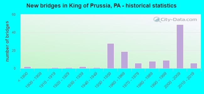
- New bridges - historical statistics
- 2Before 1900
- 11910-1919
- 11920-1929
- 21930-1939
- 11940-1949
- 281950-1959
- 191960-1969
- 61970-1979
- 81980-1989
- 91990-1999
- 492000-2009
- 62010-2019

- Reconstructed bridges - Historical Statistics
- 11930-1939
- 01940-1949
- 01950-1959
- 11960-1969
- 01970-1979
- 21980-1989
- 61990-1999
- 22000-2009
- 12010-2019


- Bridge Condition - Deck
- 7.7%Very good
- 55.8%Good
- 13.5%Satisfactory
- 17.3%Fair
- 3.8%Poor
- 1.9%Serious

- Bridge Condition - Superstructure
- 20.4%Very good
- 35.2%Good
- 22.2%Satisfactory
- 14.8%Fair
- 7.4%Poor

- Bridge Condition - Substructure
- 3.7%Very good
- 42.6%Good
- 25.9%Satisfactory
- 22.2%Fair
- 5.6%Poor

- Bridge Condition - Channel
- 3.6%Very good
- 14.3%Good
- 17.9%Satisfactory
- 42.9%Fair
- 21.4%Poor

- Bridge Condition - Culverts
- 36.4%Good
- 27.3%Satisfactory
- 27.3%Fair
- 9.1%Critical
Find on map >> Show street view
Structure Number: 27453, Location: VALLEY FORGE 27J12/3366D5 (Lat: 40.097228, Lng: -75.418003), Route carried "under" structure: State highway , Year Built: 1966, Structure Length: 0. m, Average Daily Traffic: 17,605 (year 2022), Truck Traffic: 2%, Features Intersected: NORTH GULPH ROAD, Facility Carried by Structure: WB COUNTY LINE EXP
Minimum Vertical Clearance: 4.37m (14.34ft), Kilometerpoint: 7.886, Lanes on structure: 3, Lanes under structure: 3, Material/Design: Prestressed concrete, Design/Construction: Stringer/Multi-beam, Length of Maximum Span: 26.8m (87.9ft)
Find on map >> Show street view
Structure Number: 27459, Location: RADNOR;LOWER MERI. 14J07 (Lat: 40.049444, Lng: -75.346722), Route carried "under" structure: Interstate 476, Year Built: 1974, Structure Length: 0. m, Average Daily Traffic: 62,645 (year 2022), Truck Traffic: 10%, Features Intersected: MID-COUNTY EXPRESSWAY, Facility Carried by Structure: COUNTY LINE ROAD
Minimum Vertical Clearance: 5.21m (17.09ft), Kilometerpoint: 22.470, Lanes on structure: 2, Lanes under structure: 3, Material/Design: Prestressed concrete, Design/Construction: Stringer/Multi-beam, Length of Maximum Span: 32.9m (107.9ft)
Find on map >> Show street view
Structure Number: 27459, Location: RADNOR;LOWER MERI. 14J07 (Lat: 40.049444, Lng: -75.346722), Route carried "under" structure: Interstate 476, Year Built: 1974, Structure Length: 0. m, Average Daily Traffic: 60,827 (year 2022), Truck Traffic: 10%, Features Intersected: MID-COUNTY EXPRESSWAY, Facility Carried by Structure: COUNTY LINE ROAD
Minimum Vertical Clearance: 4.88m (16.01ft), Kilometerpoint: 22.503, Lanes on structure: 2, Lanes under structure: 3, Material/Design: Prestressed concrete, Design/Construction: Stringer/Multi-beam, Length of Maximum Span: 32.9m (107.9ft)
Find on map >> Show street view
Structure Number: 28004, Location: VALLEY FORGE INTERCHANGE (Lat: 40.091700, Lng: -75.409997), Route carried "under" structure: Ramp Interstate 76, Year Built: 2008, Structure Length: 0. m, Average Daily Traffic: 43,722 (year 1993), Truck Traffic: 9%, Features Intersected: I-76 RAMPS AB
Minimum Vertical Clearance: 4.88m (16.01ft), Kilometerpoint: 0.000, Lanes on structure: 5, Lanes under structure: 3, Toll: On toll road, Material/Design: Steel, Design/Construction: Stringer/Multi-beam, Length of Maximum Span: 38.4m (126.0ft)
Find on map >> Show street view
Structure Number: 28145, Location: NEAR KING OF PRUSSIA (Lat: 40.091958, Lng: -75.385439), Route carried "under" structure: Interstate 276, Year Built: 1954, Structure Length: 0. m, Average Daily Traffic: 55,966 (year 2001), Truck Traffic: 14%, Features Intersected: PA TPK (I-276), Facility Carried by Structure: T-110 (SB)
Minimum Vertical Clearance: 4.88m (16.01ft), Kilometerpoint: 0.000, Lanes on structure: 2, Lanes under structure: 6, Material/Design: Steel, Design/Construction: Girder and Floorbeam System, Length of Maximum Span: 55.5m (182.1ft)
Find on map >> Show street view
Structure Number: 28301, Location: U. MER. TWP. 27J12/3366D5 (Lat: 40.091111, Lng: -75.415833), Route carried "under" structure: US 422, Year Built: 1965, Structure Length: 0. m, Average Daily Traffic: 43,271 (year 2021), Truck Traffic: 5%, Features Intersected: 422-COUNTY LINE EXPRESS
Minimum Vertical Clearance: 4.75m (15.58ft), Kilometerpoint: 30.307, Lanes on structure: 2, Lanes under structure: 2, Material/Design: Prestressed concrete, Design/Construction: Stringer/Multi-beam, Length of Maximum Span: 20.7m (67.9ft)
Find on map >> Show street view
Structure Number: 28301, Location: U. MER. TWP. 27J12/3366D5 (Lat: 40.091111, Lng: -75.415833), Route carried "under" structure: US 422, Year Built: 1965, Structure Length: 0. m, Average Daily Traffic: 40,822 (year 2021), Truck Traffic: 6%, Features Intersected: 422-COUNTY LINE EXPRESS
Minimum Vertical Clearance: 4.80m (15.75ft), Kilometerpoint: 30.309, Lanes on structure: 2, Lanes under structure: 2, Material/Design: Prestressed concrete, Design/Construction: Stringer/Multi-beam, Length of Maximum Span: 20.7m (67.9ft)
Find on map >> Show street view
Structure Number: 41218, Location: S. VALLEY FORGE 24K2 (Lat: 40.077475, Lng: -75.411292), Route carried "under" structure: Ramp State highway , Year Built: 2001, Structure Length: 0. m, Average Daily Traffic: 16,195 (year 2021), Truck Traffic: 12%, Features Intersected: US-202,RMPS L & BC-2, Facility Carried by Structure: OLD EAGLE SCHOL RD
Minimum Vertical Clearance: 5.28m (17.32ft), Kilometerpoint: 0.000, Lanes on structure: 3, Lanes under structure: 2, Material/Design: Steel continuous, Design/Construction: Stringer/Multi-beam, Length of Maximum Span: 54.6m (179.1ft)
Find on map >> Show street view
Structure Number: 41218, Location: S. VALLEY FORGE 24K2 (Lat: 40.077475, Lng: -75.411292), Route carried "under" structure: Ramp State highway , Year Built: 2001, Structure Length: 0. m, Average Daily Traffic: 3,591 (year 2022), Truck Traffic: 8%, Features Intersected: US-202,RMPS L & BC-2, Facility Carried by Structure: OLD EAGLE SCHOL RD
Minimum Vertical Clearance: 6.15m (20.18ft), Kilometerpoint: 0.000, Lanes on structure: 3, Lanes under structure: 1, Material/Design: Steel continuous, Design/Construction: Stringer/Multi-beam, Length of Maximum Span: 54.6m (179.1ft)
Find on map >> Show street view
Structure Number: 41218, Location: S. VALLEY FORGE 24K2 (Lat: 40.077475, Lng: -75.411292), Route carried "under" structure: US 202, Year Built: 2001, Structure Length: 0. m, Average Daily Traffic: 44,593 (year 2022), Truck Traffic: 7%, Features Intersected: US-202,RMPS L & BC-2, Facility Carried by Structure: OLD EAGLE SCHOL RD
Minimum Vertical Clearance: 5.54m (18.18ft), Kilometerpoint: 32.436, Lanes on structure: 3, Lanes under structure: 3, Material/Design: Steel continuous, Design/Construction: Stringer/Multi-beam, Length of Maximum Span: 54.6m (179.1ft)
Find on map >> Show street view
Structure Number: 41218, Location: S. VALLEY FORGE 24K2 (Lat: 40.077475, Lng: -75.411292), Route carried "under" structure: US 202, Year Built: 2001, Structure Length: 0. m, Average Daily Traffic: 45,107 (year 2022), Truck Traffic: 7%, Features Intersected: US-202,RMPS L & BC-2, Facility Carried by Structure: OLD EAGLE SCHOL RD
Minimum Vertical Clearance: 6.02m (19.75ft), Kilometerpoint: 32.486, Lanes on structure: 3, Lanes under structure: 2, Material/Design: Steel continuous, Design/Construction: Stringer/Multi-beam, Length of Maximum Span: 54.6m (179.1ft)
Find on map >> Show street view
Structure Number: 41219, Location: K OF PRUSSIA 34B1/3366G7 (Lat: 40.084078, Lng: -75.392997), Route carried "under" structure: Ramp State highway , Year Built: 2002, Structure Length: 0. m, Average Daily Traffic: 18,606 (year 2022), Truck Traffic: 7%, Features Intersected: SCHUYLKILL EXPWY, RAMP D, Facility Carried by Structure: RAMP B
Minimum Vertical Clearance: 4.70m (15.42ft), Kilometerpoint: 0.000, Lanes on structure: 2, Lanes under structure: 2, Material/Design: Steel continuous, Design/Construction: Stringer/Multi-beam, Length of Maximum Span: 29.0m (95.1ft)
Find on map >> Show street view
Structure Number: 41219, Location: K OF PRUSSIA 34B1/3366G7 (Lat: 40.084078, Lng: -75.392997), Route carried "under" structure: Interstate 76, Year Built: 2002, Structure Length: 0. m, Average Daily Traffic: 36,626 (year 2022), Truck Traffic: 10%, Features Intersected: SCHUYLKILL EXPWY, RAMP D, Facility Carried by Structure: RAMP B
Minimum Vertical Clearance: 4.47m (14.67ft), Kilometerpoint: 0.000, Lanes on structure: 2, Lanes under structure: 3, Material/Design: Steel continuous, Design/Construction: Stringer/Multi-beam, Length of Maximum Span: 29.0m (95.1ft)
Find on map >> Show street view
Structure Number: 41219, Location: K OF PRUSSIA 34B1/3366G7 (Lat: 40.084078, Lng: -75.392997), Route carried "under" structure: Interstate 76, Year Built: 2002, Structure Length: 0. m, Average Daily Traffic: 32,054 (year 2022), Truck Traffic: 10%, Features Intersected: SCHUYLKILL EXPWY, RAMP D, Facility Carried by Structure: RAMP B
Minimum Vertical Clearance: 4.57m (14.99ft), Kilometerpoint: 0.000, Lanes on structure: 2, Lanes under structure: 3, Material/Design: Steel continuous, Design/Construction: Stringer/Multi-beam, Length of Maximum Span: 29.0m (95.1ft)
Find on map >> Show street view
Structure Number: 41226, Location: .5MI SE TPK.EXIT24 34B01 (Lat: 40.083139, Lng: -75.397119), Route carried "under" structure: Ramp State highway , Year Built: 2003, Structure Length: 0. m, Average Daily Traffic: 22,553 (year 2022), Truck Traffic: 10%, Features Intersected: RAMP 'B', Facility Carried by Structure: RAMP 'A-1'
Minimum Vertical Clearance: 5.15m (16.90ft), Kilometerpoint: 0.000, Lanes on structure: 1, Lanes under structure: 2, Material/Design: Steel, Design/Construction: Stringer/Multi-beam, Length of Maximum Span: 46.6m (152.9ft)
Find on map >> Show street view
Structure Number: 41227, Location: S.I-76/202 34A2/3366F8 (Lat: 40.079444, Lng: -75.400833), Route carried "under" structure: Ramp State highway , Year Built: 2001, Structure Length: 0. m, Average Daily Traffic: 45,742 (year 2022), Truck Traffic: 5%, Features Intersected: RAMPS L AND Q, Facility Carried by Structure: SOUTH WARNER ROAD
Minimum Vertical Clearance: 4.85m (15.91ft), Kilometerpoint: 0.000, Lanes on structure: 4, Lanes under structure: 3, Material/Design: Steel, Design/Construction: Stringer/Multi-beam, Length of Maximum Span: 25.0m (82.0ft)
Find on map >> Show street view
Structure Number: 41227, Location: S.I-76/202 34A2/3366F8 (Lat: 40.079444, Lng: -75.400833), Route carried "under" structure: Ramp State highway , Year Built: 2001, Structure Length: 0. m, Average Daily Traffic: 16,959 (year 2022), Truck Traffic: 8%, Features Intersected: RAMPS L AND Q, Facility Carried by Structure: SOUTH WARNER ROAD
Minimum Vertical Clearance: 4.72m (15.49ft), Kilometerpoint: 0.000, Lanes on structure: 4, Lanes under structure: 1, Material/Design: Steel, Design/Construction: Stringer/Multi-beam, Length of Maximum Span: 25.0m (82.0ft)
Find on map >> Show street view
Structure Number: 41228, Location: KING OF PRUSSIA 34A01 (Lat: 40.081514, Lng: -75.402733), Route carried "under" structure: US 202, Year Built: 2001, Structure Length: 0. m, Average Daily Traffic: 43,484 (year 2022), Truck Traffic: 4%, Features Intersected: US RTE 202;RMPS F1 AND S, Facility Carried by Structure: SOUTH WARNER ROAD
Minimum Vertical Clearance: 5.97m (19.59ft), Kilometerpoint: 0.369, Lanes on structure: 3, Lanes under structure: 3, Material/Design: Steel continuous, Design/Construction: Stringer/Multi-beam, Length of Maximum Span: 35.7m (117.1ft)
Find on map >> Show street view
Structure Number: 41228, Location: KING OF PRUSSIA 34A01 (Lat: 40.081514, Lng: -75.402733), Route carried "under" structure: Ramp State highway , Year Built: 2001, Structure Length: 0. m, Average Daily Traffic: 22,553 (year 2022), Truck Traffic: 10%, Features Intersected: US RTE 202;RMPS F1 AND S, Facility Carried by Structure: SOUTH WARNER ROAD
Minimum Vertical Clearance: 5.33m (17.49ft), Kilometerpoint: 0.000, Lanes on structure: 3, Lanes under structure: 1, Material/Design: Steel continuous, Design/Construction: Stringer/Multi-beam, Length of Maximum Span: 35.7m (117.1ft)
Find on map >> Show street view
Structure Number: 41228, Location: KING OF PRUSSIA 34A01 (Lat: 40.081514, Lng: -75.402733), Route carried "under" structure: US 202, Year Built: 2001, Structure Length: 0. m, Average Daily Traffic: 54,114 (year 2022), Truck Traffic: 4%, Features Intersected: US RTE 202;RMPS F1 AND S, Facility Carried by Structure: SOUTH WARNER ROAD
Minimum Vertical Clearance: 5.79m (19.00ft), Kilometerpoint: 0.364, Lanes on structure: 3, Lanes under structure: 3, Material/Design: Steel continuous, Design/Construction: Stringer/Multi-beam, Length of Maximum Span: 35.7m (117.1ft)
Find on map >> Show street view
Structure Number: 41228, Location: KING OF PRUSSIA 34A01 (Lat: 40.081514, Lng: -75.402733), Route carried "under" structure: Ramp State highway 8047, Year Built: 2001, Structure Length: 0. m, Average Daily Traffic: 122 (year 2001), Truck Traffic: 7%, Features Intersected: US RTE 202;RMPS F1 AND S, Facility Carried by Structure: SOUTH WARNER ROAD
Minimum Vertical Clearance: 6.07m (19.91ft), Kilometerpoint: 0.000, Lanes on structure: 3, Lanes under structure: 1, Material/Design: Steel continuous, Design/Construction: Stringer/Multi-beam, Length of Maximum Span: 35.7m (117.1ft)
Find on map >> Show street view
Structure Number: 41238, Location: .2 MI NE DEVON PK 25A2 (Lat: 40.078711, Lng: -75.404758), Route carried "under" structure: Ramp State highway , Year Built: 2001, Structure Length: 0. m, Average Daily Traffic: 45,742 (year 2022), Truck Traffic: 5%, Features Intersected: RAMPS L,N,Q, Facility Carried by Structure: RAMP P
Minimum Vertical Clearance: 4.80m (15.75ft), Kilometerpoint: 0.000, Lanes on structure: 1, Lanes under structure: 3, Material/Design: Steel, Design/Construction: Stringer/Multi-beam, Length of Maximum Span: 52.4m (171.9ft)
Find on map >> Show street view
Structure Number: 41238, Location: .2 MI NE DEVON PK 25A2 (Lat: 40.078711, Lng: -75.404758), Route carried "under" structure: Ramp State highway , Year Built: 2001, Structure Length: 0. m, Average Daily Traffic: 16,959 (year 2022), Truck Traffic: 8%, Features Intersected: RAMPS L,N,Q, Facility Carried by Structure: RAMP P
Minimum Vertical Clearance: 4.75m (15.58ft), Kilometerpoint: 0.000, Lanes on structure: 1, Lanes under structure: 1, Material/Design: Steel, Design/Construction: Stringer/Multi-beam, Length of Maximum Span: 52.4m (171.9ft)
Find on map >> Show street view
Structure Number: 41239, Location: SW WARNER RD 34A2/3366F8 (Lat: 40.079011, Lng: -75.403458), Route carried "under" structure: Ramp State highway , Year Built: 2001, Structure Length: 0. m, Average Daily Traffic: 16,959 (year 2022), Truck Traffic: 8%, Features Intersected: RAMPS L AND Q, Facility Carried by Structure: DEVON PARK DRIVE
Minimum Vertical Clearance: 4.72m (15.49ft), Kilometerpoint: 0.000, Lanes on structure: 3, Lanes under structure: 1, Material/Design: Steel continuous, Design/Construction: Stringer/Multi-beam, Length of Maximum Span: 50.3m (165.0ft)
Find on map >> Show street view
Structure Number: 41239, Location: SW WARNER RD 34A2/3366F8 (Lat: 40.079011, Lng: -75.403458), Route carried "under" structure: Ramp State highway , Year Built: 2001, Structure Length: 0. m, Average Daily Traffic: 45,742 (year 2022), Truck Traffic: 5%, Features Intersected: RAMPS L AND Q, Facility Carried by Structure: DEVON PARK DRIVE
Minimum Vertical Clearance: 5.77m (18.93ft), Kilometerpoint: 0.000, Lanes on structure: 3, Lanes under structure: 3, Material/Design: Steel continuous, Design/Construction: Stringer/Multi-beam, Length of Maximum Span: 50.3m (165.0ft)
Find on map >> Show street view
Structure Number: 41245, Location: .1MI.N.INT.DV.PK 25A2 (Lat: 40.078961, Lng: -75.405222), Route carried "under" structure: Ramp State highway , Year Built: 2001, Structure Length: 0. m, Average Daily Traffic: 8,144 (year 2022), Truck Traffic: 8%, Features Intersected: RAMPS L,N,Q,R,S, Facility Carried by Structure: RAMP O
Minimum Vertical Clearance: 5.49m (18.01ft), Kilometerpoint: 0.000, Lanes on structure: 1, Lanes under structure: 1, Material/Design: Steel continuous, Design/Construction: Stringer/Multi-beam, Length of Maximum Span: 26.8m (87.9ft)
Find on map >> Show street view
Structure Number: 41245, Location: .1MI.N.INT.DV.PK 25A2 (Lat: 40.078961, Lng: -75.405222), Route carried "under" structure: Ramp State highway , Year Built: 2001, Structure Length: 0. m, Average Daily Traffic: 11,128 (year 2022), Truck Traffic: 7%, Features Intersected: RAMPS L,N,Q,R,S, Facility Carried by Structure: RAMP O
Minimum Vertical Clearance: 5.28m (17.32ft), Kilometerpoint: 0.000, Lanes on structure: 1, Lanes under structure: 2, Material/Design: Steel continuous, Design/Construction: Stringer/Multi-beam, Length of Maximum Span: 26.8m (87.9ft)
Find on map >> Show street view
Structure Number: 41245, Location: .1MI.N.INT.DV.PK 25A2 (Lat: 40.078961, Lng: -75.405222), Route carried "under" structure: Ramp State highway , Year Built: 2001, Structure Length: 0. m, Average Daily Traffic: 16,959 (year 2022), Truck Traffic: 8%, Features Intersected: RAMPS L,N,Q,R,S, Facility Carried by Structure: RAMP O
Minimum Vertical Clearance: 5.64m (18.50ft), Kilometerpoint: 0.000, Lanes on structure: 1, Lanes under structure: 1, Material/Design: Steel continuous, Design/Construction: Stringer/Multi-beam, Length of Maximum Span: 26.8m (87.9ft)
Find on map >> Show street view
Structure Number: 41245, Location: .1MI.N.INT.DV.PK 25A2 (Lat: 40.078961, Lng: -75.405222), Route carried "under" structure: Ramp State highway , Year Built: 2001, Structure Length: 0. m, Average Daily Traffic: 45,742 (year 2022), Truck Traffic: 5%, Features Intersected: RAMPS L,N,Q,R,S, Facility Carried by Structure: RAMP O
Minimum Vertical Clearance: 6.15m (20.18ft), Kilometerpoint: 0.000, Lanes on structure: 1, Lanes under structure: 3, Material/Design: Steel continuous, Design/Construction: Stringer/Multi-beam, Length of Maximum Span: 26.8m (87.9ft)
Find on map >> Show street view
Structure Number: 4125, Location: .4MI.S.INTER 34B01/3366G7 (Lat: 40.083544, Lng: -75.394683), Route carried "under" structure: Ramp State highway , Year Built: 2002, Structure Length: 0. m, Average Daily Traffic: 18,606 (year 2022), Truck Traffic: 7%, Features Intersected: SCHUYLKILL EXPWY;RAMP D, Facility Carried by Structure: RAMP D-2
Minimum Vertical Clearance: 6.32m (20.73ft), Kilometerpoint: 0.000, Lanes on structure: 1, Lanes under structure: 2, Material/Design: Steel continuous, Design/Construction: Stringer/Multi-beam, Length of Maximum Span: 30.5m (100.1ft)
Find on map >> Show street view
Structure Number: 4125, Location: .4MI.S.INTER 34B01/3366G7 (Lat: 40.083544, Lng: -75.394683), Route carried "under" structure: Interstate 76, Year Built: 2002, Structure Length: 0. m, Average Daily Traffic: 36,626 (year 2022), Truck Traffic: 10%, Features Intersected: SCHUYLKILL EXPWY;RAMP D, Facility Carried by Structure: RAMP D-2
Minimum Vertical Clearance: 5.43m (17.81ft), Kilometerpoint: 0.000, Lanes on structure: 1, Lanes under structure: 3, Material/Design: Steel continuous, Design/Construction: Stringer/Multi-beam, Length of Maximum Span: 30.5m (100.1ft)
Find on map >> Show street view
Structure Number: 4125, Location: .4MI.S.INTER 34B01/3366G7 (Lat: 40.083544, Lng: -75.394683), Route carried "under" structure: Interstate 76, Year Built: 2002, Structure Length: 0. m, Average Daily Traffic: 32,054 (year 2022), Truck Traffic: 10%, Features Intersected: SCHUYLKILL EXPWY;RAMP D, Facility Carried by Structure: RAMP D-2
Minimum Vertical Clearance: 5.74m (18.83ft), Kilometerpoint: 0.000, Lanes on structure: 1, Lanes under structure: 5, Material/Design: Steel continuous, Design/Construction: Stringer/Multi-beam, Length of Maximum Span: 30.5m (100.1ft)
Find on map >> Show street view
Structure Number: 41303, Location: .2MI.S.GULPH RD 34C01 (Lat: 40.084367, Lng: -75.393108), Route carried "under" structure: Ramp State highway , Year Built: 2003, Structure Length: 0. m, Average Daily Traffic: 22,553 (year 2022), Truck Traffic: 10%, Features Intersected: RAMP B ( WB I76)/3366-H7, Facility Carried by Structure: RAMP D-2 TO RT 422
Minimum Vertical Clearance: 5.25m (17.22ft), Kilometerpoint: 0.000, Lanes on structure: 1, Lanes under structure: 2, Material/Design: Steel, Design/Construction: Stringer/Multi-beam, Length of Maximum Span: 26.2m (86.0ft)
Find on map >> Show street view
Structure Number: 41304, Location: .3MI.S.GULPH RD 3366H07 (Lat: 40.083164, Lng: -75.391492), Route carried "under" structure: Ramp State highway , Year Built: 2003, Structure Length: 0. m, Average Daily Traffic: 18,606 (year 2022), Truck Traffic: 7%, Features Intersected: RAMP D / 3366-H7, Facility Carried by Structure: RAMP I
Minimum Vertical Clearance: 4.72m (15.49ft), Kilometerpoint: 0.000, Lanes on structure: 1, Lanes under structure: 2, Material/Design: Steel, Design/Construction: Stringer/Multi-beam, Length of Maximum Span: 26.8m (87.9ft)
Find on map >> Show street view
Structure Number: 41305, Location: .SMI.S.GULPH ROAD 34C01 (Lat: 40.083600, Lng: -75.394133), Route carried "under" structure: Ramp State highway , Year Built: 2003, Structure Length: 0. m, Average Daily Traffic: 22,553 (year 2022), Truck Traffic: 10%, Features Intersected: RAMP B / 3366-H7, Facility Carried by Structure: RAMP E
Minimum Vertical Clearance: 5.70m (18.70ft), Kilometerpoint: 0.000, Lanes on structure: 1, Lanes under structure: 2, Material/Design: Steel, Design/Construction: Stringer/Multi-beam, Length of Maximum Span: 22.3m (73.2ft)
Find on map >> Show street view
Structure Number: 4427, Location: NEAR KING OF P 28E13 (Lat: 40.090175, Lng: -75.376556), Route carried "under" structure: Interstate 276, Year Built: 2006, Structure Length: 0. m, Average Daily Traffic: 55,966 (year 2001), Truck Traffic: 14%, Features Intersected: PA. TRNPK( I-276)/3366K6, Facility Carried by Structure: US202-SR0202,LR143
Minimum Vertical Clearance: 5.08m (16.67ft), Kilometerpoint: 0.000, Lanes on structure: 4, Lanes under structure: 7, Toll: On toll road, Material/Design: Steel continuous, Design/Construction: Stringer/Multi-beam, Length of Maximum Span: 45.1m (148.0ft)
Find on map >> Show street view
Structure Number: 54599, Location: 422 INTERCHANGE 3366C04 (Lat: 40.101139, Lng: -75.418806), Route carried "under" structure: US 422, Year Built: 2017, Structure Length: 0. m, Average Daily Traffic: 40,822 (year 2021), Truck Traffic: 6%, Features Intersected: COUNTY LINE EXPRESSWAY, Facility Carried by Structure: VALLEY FORGE ROAD
Minimum Vertical Clearance: 5.03m (16.50ft), Kilometerpoint: 30.309, Lanes on structure: 3, Lanes under structure: 2, Material/Design: Prestressed concrete continuous, Design/Construction: Stringer/Multi-beam, Length of Maximum Span: 33.5m (109.9ft)
Find on map >> Show street view
Structure Number: 54599, Location: 422 INTERCHANGE 3366C04 (Lat: 40.101139, Lng: -75.418806), Route carried "under" structure: US 422, Year Built: 2017, Structure Length: 0. m, Average Daily Traffic: 43,271 (year 2021), Truck Traffic: 5%, Features Intersected: COUNTY LINE EXPRESSWAY, Facility Carried by Structure: VALLEY FORGE ROAD
Minimum Vertical Clearance: 5.03m (16.50ft), Kilometerpoint: 30.307, Lanes on structure: 3, Lanes under structure: 2, Material/Design: Prestressed concrete continuous, Design/Construction: Stringer/Multi-beam, Length of Maximum Span: 33.5m (109.9ft)
Find on map >> Show street view
Structure Number: 55826, Location: SR422/SR23 INTC. 3366C04 (Lat: 40.104844, Lng: -75.420250), Route carried "under" structure: US 422, Year Built: 2018, Structure Length: 0. m, Average Daily Traffic: 40,822 (year 2021), Truck Traffic: 6%, Features Intersected: U.S. 422, Facility Carried by Structure: RAMP B
Minimum Vertical Clearance: 5.15m (16.90ft), Kilometerpoint: 29.245, Lanes on structure: 2, Lanes under structure: 4, Material/Design: Steel continuous, Design/Construction: Stringer/Multi-beam, Length of Maximum Span: 29.9m (98.1ft)
Find on map >> Show street view
Structure Number: 55826, Location: SR422/SR23 INTC. 3366C04 (Lat: 40.104844, Lng: -75.420250), Route carried "under" structure: US 422, Year Built: 2018, Structure Length: 0. m, Average Daily Traffic: 43,271 (year 2021), Truck Traffic: 5%, Features Intersected: U.S. 422, Facility Carried by Structure: RAMP B
Minimum Vertical Clearance: 5.15m (16.90ft), Kilometerpoint: 29.234, Lanes on structure: 2, Lanes under structure: 3, Material/Design: Steel continuous, Design/Construction: Stringer/Multi-beam, Length of Maximum Span: 29.9m (98.1ft)