Bridge Statistics for Lufkin, Texas (TX)
Condition, Traffic, Stress, Structural Evaluation, Project Costs
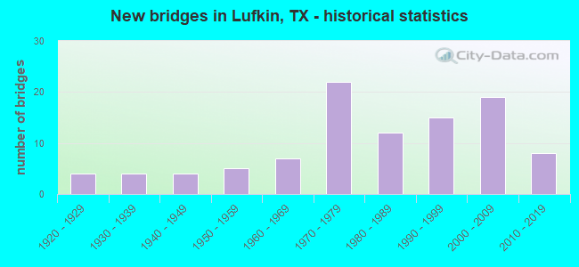
- New bridges - historical statistics
- 41920-1929
- 41930-1939
- 41940-1949
- 51950-1959
- 71960-1969
- 221970-1979
- 121980-1989
- 151990-1999
- 192000-2009
- 82010-2019

- Reconstructed bridges - Historical Statistics
- 31950-1959
- 61960-1969
- 11970-1979
- 31980-1989
- 01990-1999
- 22000-2009


- Bridge Condition - Deck
- 10.2%Very good
- 59.2%Good
- 28.6%Satisfactory
- 2.0%Fair

- Bridge Condition - Superstructure
- 20.4%Very good
- 49.0%Good
- 26.5%Satisfactory
- 2.0%Fair
- 2.0%Poor

- Bridge Condition - Substructure
- 8.2%Very good
- 61.2%Good
- 26.5%Satisfactory
- 4.1%Fair

- Bridge Condition - Channel
- 22.9%Good
- 62.5%Satisfactory
- 10.4%Fair
- 4.2%Poor

- Bridge Condition - Culverts
- 44.4%Good
- 51.9%Satisfactory
- 3.7%Fair
Find on map >> Show street view
Structure Number: 110030255301012, Location: 1.25 MI W OF US 59 (Lat: 31.371150, Lng: -94.731319), Route carried "on" structure: Alternate US 69, Year Built: 1971, Status: Open, Structure Length: 1.62m (5.31ft), Average Daily Traffic: 13,292 (year 2020), Truck Traffic: 7%, Average Future Daily Traffic: 17,730 (year 2030), Features Intersected: DRAW, Facility Carried by Structure: LP 287
Minimum Vertical Clearance: 30+ m (98+ ft), Kilometerpoint: 13.958, Lanes on structure: 4, Base Highway Network: Yes, Owner: State Highway Agency, Approaching Roadway Width: 24.4m (80.1ft), Material/Design: Concrete, Design/Construction: Culvert, Number Of Spans In Main Unit: 5, Length of Maximum Span: 3.0m (9.8ft), Curb-To-Curb Width: 24.4m (80.1ft), Out-to-Out Width: 38.8m (127.3ft)
Condition: Channel: Satisfactory, Culverts: Good, Operating Rating: 39.9 metric tons, Method Used To Determine Operating Rating: Load Factor (LF), Inventory Rating: 23.6 metric tons, Method Used To Determine Inventory Rating: Load Factor (LF), Structural Evaluation: Somewhat better than minimum adequacy, Deck Geometry: Superior to present desirable criteria, Waterway Adequacy: Equal to present minimum criteria, Approach Roadway Alignment: Equal to present desirable criteria, Designated Inspection Frequency: Every 24 months, Inspection Date: May 2020, Deck Structure Type: Concrete Cast-file-Place, Wearing Surface/Protective System: Wearing Surface: Bituminous
Find on map >> Show street view
Structure Number: 110030255301014, Location: 0.5 MI N OF SH 103 (Lat: 31.358864, Lng: -94.699569), Route carried "on" structure: Alternate US 59, Year Built: 1971, Status: Open, Structure Length: 0.64m (2.10ft), Average Daily Traffic: 30,000 (year 2010), Truck Traffic: 13%, Average Future Daily Traffic: 42,450 (year 2030), Design Load: HS 20, Features Intersected: SHIREY CREEK
Minimum Vertical Clearance: 30+ m (98+ ft), Kilometerpoint: 17.754, Lanes on structure: 6, Base Highway Network: Yes, Owner: State Highway Agency, Approaching Roadway Width: 35.1m (115.2ft), Skew: 20 degrees, Material/Design: Concrete, Design/Construction: Culvert, Number Of Spans In Main Unit: 2, Length of Maximum Span: 3.0m (9.8ft)
Condition: Channel: Satisfactory, Culverts: Satisfactory, Operating Rating: 39.9 metric tons, Method Used To Determine Operating Rating: Load Factor (LF), Inventory Rating: 23.6 metric tons, Method Used To Determine Inventory Rating: Load Factor (LF), Structural Evaluation: Somewhat better than minimum adequacy, Waterway Adequacy: Equal to present minimum criteria, Approach Roadway Alignment: Equal to present desirable criteria, Designated Inspection Frequency: Every 24 months, Inspection Date: May 2020
Find on map >> Show street view
Structure Number: 110030255301015, Location: 0.80 MI NE OF US 69 (Lat: 31.329675, Lng: -94.690656), Route carried "on" structure: Business US 59, Year Built: 1988, Status: Open, Structure Length: 8.38m (27.49ft), Average Daily Traffic: 38,262 (year 2019), Truck Traffic: 22%, Average Future Daily Traffic: 53,740 (year 2033), Design Load: HS 20, Features Intersected: FM 841
Minimum Vertical Clearance: 30+ m (98+ ft), Kilometerpoint: 21.250, Lanes on structure: 4, Lanes under structure: 5, Owner: State Highway Agency, Approaching Roadway Width: 24.4m (80.1ft), Skew: 20 degrees, Material/Design: Prestressed concrete, Design/Construction: Stringer/Multi-beam, Number Of Spans In Main Unit: 3, Length of Maximum Span: 32.0m (105.0ft), Curb-To-Curb Width: 24.4m (80.1ft), Out-to-Out Width: 25.3m (83.0ft)
Condition: Deck: Good, Superstructure: Good, Substructure: Good, Operating Rating: 54.4 metric tons, Method Used To Determine Operating Rating: Assigned rating based on Load Factor Design (LFD) reported in metric tons, Inventory Rating: 32.7 metric tons, Method Used To Determine Inventory Rating: Assigned rating based on Load Factor Design (LFD) reported in metric tons, Structural Evaluation: Better than present minimum criteria, Deck Geometry: Superior to present desirable criteria, Underclear: Better than present minimum criteria, Approach Roadway Alignment: Equal to present desirable criteria, Designated Inspection Frequency: Every 24 months, Inspection Date: May 2020, Deck Structure Type: Concrete Precast Panels
Find on map >> Show street view
Structure Number: 110030255301016, Location: AT US 59/SOUTH INTERCHANG (Lat: 31.309683, Lng: -94.726428), Route carried "on" structure: ServiceState highway 287, Year Built: 1988, Status: Open, Structure Length: 3.35m (10.99ft), Average Daily Traffic: 3,950 (year 2010), Truck Traffic: 12%, Average Future Daily Traffic: 6,660 (year 2030), Design Load: HS 20, Features Intersected: LP 287
Minimum Vertical Clearance: 3.94m (12.93ft), Kilometerpoint: 25.572, Lanes on structure: 1, Lanes under structure: 4, Base Highway Network: Yes, Owner: State Highway Agency, Approaching Roadway Width: 5.8m (19.0ft), Skew: 2 degrees, Material/Design: Prestressed concrete, Design/Construction: Box Beam or Girders - Multiple, Number Of Spans In Main Unit: 2, Length of Maximum Span: 16.8m (55.1ft), Curb-To-Curb Width: 5.8m (19.0ft), Out-to-Out Width: 6.8m (22.3ft)
Condition: Deck: Very good, Superstructure: Satisfactory, Substructure: Good, Operating Rating: 54.4 metric tons, Method Used To Determine Operating Rating: Assigned rating based on Load Factor Design (LFD) reported in metric tons, Inventory Rating: 32.7 metric tons, Method Used To Determine Inventory Rating: Assigned rating based on Load Factor Design (LFD) reported in metric tons, Structural Evaluation: Equal to present minimum criteria, Deck Geometry: High priority of replacement, Underclear: Equal to present minimum criteria, Approach Roadway Alignment: Somewhat better than minimum adequacy, Designated Inspection Frequency: Every 24 months, Inspection Date: May 2020, Deck Structure Type: Concrete Cast-file-Place, Wearing Surface/Protective System: Wearing Surface: Bituminous
Find on map >> Show street view
Structure Number: 11003025530106, Location: 1.10 MI S OF SH 103 (Lat: 31.336603, Lng: -94.690558), Route carried "on" structure: US 59, Year Built: 1974, Status: Open, Structure Length: 8.23m (27.00ft), Average Daily Traffic: 39,510 (year 2013), Truck Traffic: 22%, Average Future Daily Traffic: 55,320 (year 2033), Design Load: HS 20, Features Intersected: FM 325, Facility Carried by Structure: LP 287
Minimum Vertical Clearance: 30+ m (98+ ft), Kilometerpoint: 20.418, Lanes on structure: 4, Lanes under structure: 7, Owner: State Highway Agency, Approaching Roadway Width: 24.4m (80.1ft), Skew: 30 degrees, Material/Design: Prestressed concrete, Design/Construction: Stringer/Multi-beam, Number Of Spans In Main Unit: 3, Length of Maximum Span: 30.5m (100.1ft), Curb-To-Curb Width: 24.4m (80.1ft), Out-to-Out Width: 26.6m (87.3ft)
Condition: Deck: Satisfactory, Superstructure: Very good, Substructure: Good, Operating Rating: 68.0 metric tons, Method Used To Determine Operating Rating: Load Factor (LF), Inventory Rating: 29.9 metric tons, Method Used To Determine Inventory Rating: Load Factor (LF), Structural Evaluation: Better than present minimum criteria, Deck Geometry: Superior to present desirable criteria, Underclear: Superior to present desirable criteria, Approach Roadway Alignment: Equal to present desirable criteria, Designated Inspection Frequency: Every 24 months, Inspection Date: May 2020, Deck Structure Type: Concrete Cast-file-Place
Find on map >> Show street view
Structure Number: 110030255301081, Location: 1.1 MI W OF US 59 (Lat: 31.309158, Lng: -94.742497), Route carried "on" structure: Alternate State highway 287, Year Built: 1961, Year Reconstructed: 1980, Status: Open, Structure Length: 7.62m (25.00ft), Average Daily Traffic: 30,952 (year 2020), Truck Traffic: 5%, Average Future Daily Traffic: 43,170 (year 2033), Features Intersected: FM 324 & SPRR
Minimum Vertical Clearance: 30+ m (98+ ft), Kilometerpoint: 3.190, Lanes on structure: 4, Lanes under structure: 4, Base Highway Network: Yes, Owner: State Highway Agency, Approaching Roadway Width: 24.4m (80.1ft), Skew: 30 degrees, Material/Design: Prestressed concrete, Design/Construction: Stringer/Multi-beam, Number Of Spans In Main Unit: 5, Length of Maximum Span: 15.2m (49.9ft), Curb-To-Curb Width: 24.4m (80.1ft), Out-to-Out Width: 25.9m (85.0ft)
Condition: Deck: Satisfactory, Superstructure: Good, Substructure: Good, Operating Rating: 54.4 metric tons, Method Used To Determine Operating Rating: Assigned rating based on Load Factor Design (LFD) reported in metric tons, Inventory Rating: 32.7 metric tons, Method Used To Determine Inventory Rating: Assigned rating based on Load Factor Design (LFD) reported in metric tons, Structural Evaluation: Better than present minimum criteria, Deck Geometry: Superior to present desirable criteria, Underclear: Meets minimum limits, Approach Roadway Alignment: Equal to present desirable criteria, Designated Inspection Frequency: Every 24 months, Inspection Date: May 2020, Deck Structure Type: Concrete Cast-file-Place, Wearing Surface/Protective System: Wearing Surface: Bituminous
Find on map >> Show street view
Structure Number: 110030255301116, Location: 1.70 MI NE OF US 59 (Lat: 31.319300, Lng: -94.699539), Route carried "on" structure: State highway 287, Year Built: 1971, Status: Open, Structure Length: 7.92m (25.98ft), Average Daily Traffic: 32,000 (year 2010), Truck Traffic: 4%, Average Future Daily Traffic: 59,240 (year 2030), Design Load: HS 20, Features Intersected: BUS 69
Minimum Vertical Clearance: 30+ m (98+ ft), Kilometerpoint: 7.009, Lanes on structure: 4, Lanes under structure: 8, Owner: State Highway Agency, Approaching Roadway Width: 24.4m (80.1ft), Skew: 30 degrees, Material/Design: Prestressed concrete, Design/Construction: Stringer/Multi-beam, Number Of Spans In Main Unit: 2, Number Of Approach Spans: 2, Length of Maximum Span: 25.9m (85.0ft), Curb-To-Curb Width: 24.4m (80.1ft), Out-to-Out Width: 26.6m (87.3ft)
Condition: Deck: Satisfactory, Superstructure: Satisfactory, Substructure: Good, Operating Rating: 60.8 metric tons, Method Used To Determine Operating Rating: Load Factor (LF), Inventory Rating: 29.9 metric tons, Method Used To Determine Inventory Rating: Load Factor (LF), Structural Evaluation: Equal to present minimum criteria, Deck Geometry: Superior to present desirable criteria, Underclear: Meets minimum limits, Approach Roadway Alignment: Equal to present desirable criteria, Designated Inspection Frequency: Every 24 months, Inspection Date: May 2020, Deck Structure Type: Concrete Cast-file-Place
Find on map >> Show street view
Structure Number: 110030316201001, Location: 1.15 MI S OF LP 287 (Lat: 31.293339, Lng: -94.737269), Route carried "on" structure: State highway 819, Year Built: 1990, Status: Open, Structure Length: 3.90m (12.80ft), Average Daily Traffic: 8,748 (year 2020), Truck Traffic: 3%, Average Future Daily Traffic: 14,850 (year 2033), Design Load: HS 20, Features Intersected: HURRICANE CREEK
Minimum Vertical Clearance: 30+ m (98+ ft), Kilometerpoint: 1.891, Lanes on structure: 2, Owner: State Highway Agency, Approaching Roadway Width: 12.2m (40.0ft), Skew: 3 degrees, Material/Design: Concrete, Design/Construction: Stringer/Multi-beam, Number Of Spans In Main Unit: 3, Length of Maximum Span: 13.1m (43.0ft), Curb-To-Curb Width: 13.3m (43.6ft), Out-to-Out Width: 14.1m (46.3ft)
Condition: Deck: Good, Superstructure: Good, Substructure: Good, Channel: Satisfactory, Operating Rating: 48.1 metric tons, Method Used To Determine Operating Rating: Load Factor (LF), Inventory Rating: 29.0 metric tons, Method Used To Determine Inventory Rating: Load Factor (LF), Structural Evaluation: Better than present minimum criteria, Deck Geometry: Somewhat better than minimum adequacy, Waterway Adequacy: Superior to present desirable criteria, Approach Roadway Alignment: Equal to present desirable criteria, Designated Inspection Frequency: Every 24 months, Inspection Date: May 2020, Deck Structure Type: Concrete Cast-file-Place
Find on map >> Show street view
Structure Number: 110030316201002, Location: 1.05 MI S OF LP 287 (Lat: 31.294250, Lng: -94.737617), Route carried "on" structure: State highway 819, Year Built: 1990, Status: Open, Structure Length: 1.19m (3.90ft), Average Daily Traffic: 8,748 (year 2020), Truck Traffic: 3%, Average Future Daily Traffic: 14,850 (year 2033), Design Load: HS 20, Features Intersected: HURICANE CREEK RELIEF
Minimum Vertical Clearance: 30+ m (98+ ft), Kilometerpoint: 1.790, Lanes on structure: 2, Owner: State Highway Agency, Approaching Roadway Width: 12.2m (40.0ft), Material/Design: Concrete, Design/Construction: Culvert, Number Of Spans In Main Unit: 7, Length of Maximum Span: 1.5m (4.9ft), Curb-To-Curb Width: 13.4m (44.0ft), Out-to-Out Width: 14.0m (45.9ft)
Condition: Channel: Good, Culverts: Satisfactory, Operating Rating: 39.9 metric tons, Method Used To Determine Operating Rating: Load Factor (LF), Inventory Rating: 23.6 metric tons, Method Used To Determine Inventory Rating: Load Factor (LF), Structural Evaluation: Somewhat better than minimum adequacy, Deck Geometry: Equal to present minimum criteria, Waterway Adequacy: Superior to present desirable criteria, Approach Roadway Alignment: Equal to present desirable criteria, Designated Inspection Frequency: Every 48 months, Inspection Date: May 2018, Deck Structure Type: Concrete Cast-file-Place, Wearing Surface/Protective System: Wearing Surface: Bituminous
Find on map >> Show street view
Structure Number: 110030341801001, Location: 0.9 MI W OF FM 324 (Lat: 31.304061, Lng: -94.755803), Route carried "on" structure: State highway 1336, Year Built: 1980, Status: Open, Structure Length: 2.44m (8.01ft), Average Daily Traffic: 1,576 (year 2020), Truck Traffic: 18%, Average Future Daily Traffic: 2,710 (year 2033), Design Load: H 15, Features Intersected: CEDAR CREEK
Minimum Vertical Clearance: 30+ m (98+ ft), Kilometerpoint: 2.882, Lanes on structure: 2, Owner: State Highway Agency, Approaching Roadway Width: 7.3m (24.0ft), Material/Design: Concrete, Design/Construction: Stringer/Multi-beam, Number Of Spans In Main Unit: 2, Length of Maximum Span: 12.2m (40.0ft), Curb-To-Curb Width: 7.9m (25.9ft), Out-to-Out Width: 8.6m (28.2ft)
Condition: Deck: Good, Superstructure: Good, Substructure: Good, Channel: Satisfactory, Operating Rating: 59.9 metric tons, Method Used To Determine Operating Rating: Load Factor (LF), Inventory Rating: 35.4 metric tons, Method Used To Determine Inventory Rating: Load Factor (LF), Structural Evaluation: Better than present minimum criteria, Deck Geometry: Meets minimum limits, Waterway Adequacy: Better than present minimum criteria, Approach Roadway Alignment: Equal to present desirable criteria, Designated Inspection Frequency: Every 24 months, Inspection Date: May 2020, Deck Structure Type: Concrete Cast-file-Place, Wearing Surface/Protective System: Wearing Surface: Bituminous
Find on map >> Show street view
Structure Number: 110030AA0203001, Location: 0.4 MI SE OF FM 842 (Lat: 31.384958, Lng: -94.666333), Route carried "on" structure: County highway 122, Year Built: 1998, Status: Open, Structure Length: 1.19m (3.90ft), Average Daily Traffic: 179 (year 2013), Average Future Daily Traffic: 270 (year 2033), Features Intersected: PAPER MILL CREEK, Facility Carried by Structure: TWIN OAKS RD
Minimum Vertical Clearance: 30+ m (98+ ft), Kilometerpoint: 3.541, Lanes on structure: 1, Owner: County Highway Agency, Approaching Roadway Width: 4.9m (16.1ft), Material/Design: Steel, Design/Construction: Stringer/Multi-beam, Number Of Spans In Main Unit: 1, Length of Maximum Span: 11.6m (38.1ft), Curb-To-Curb Width: 4.3m (14.1ft), Out-to-Out Width: 4.9m (16.1ft)
Condition: Deck: Satisfactory, Superstructure: Satisfactory, Substructure: Satisfactory, Channel: Fair, Operating Rating: 40.8 metric tons, Method Used To Determine Operating Rating: Allowable Stress (AS), Inventory Rating: 29.0 metric tons, Method Used To Determine Inventory Rating: Allowable Stress (AS), Structural Evaluation: Equal to present minimum criteria, Deck Geometry: High priority of replacement, Waterway Adequacy: Equal to present minimum criteria, Approach Roadway Alignment: Better than present minimum criteria, Length Of Structure Improvement: 1.19m (3.90ft), Designated Inspection Frequency: Every 24 months, Inspection Date: August 2021, Bridge Improvement Cost: $1,000, Total Project Cost: $1,000, Deck Structure Type: Wood or Timber, Wearing Surface/Protective System: Wearing Surface: Wood or Timber
Find on map >> Show street view
Structure Number: 110030AA0204001, Location: 0.5 MI E OF TWIN OAKS RD (Lat: 31.379561, Lng: -94.659106), Route carried "on" structure: County highway , Year Built: 1998, Status: Open, Structure Length: 1.80m (5.91ft), Average Daily Traffic: 100 (year 2018), Average Future Daily Traffic: 110 (year 2033), Features Intersected: WILLIS CREEK, Facility Carried by Structure: WILKERSON RD
Minimum Vertical Clearance: 30+ m (98+ ft), Kilometerpoint: 1.609, Lanes on structure: 1, Owner: County Highway Agency, Approaching Roadway Width: 3.5m (11.5ft), Skew: 2 degrees, Material/Design: Steel, Design/Construction: Stringer/Multi-beam, Number Of Spans In Main Unit: 1, Number Of Approach Spans: 1, Length of Maximum Span: 11.9m (39.0ft), Curb-To-Curb Width: 4.1m (13.5ft), Out-to-Out Width: 4.7m (15.4ft)
Condition: Deck: Fair, Superstructure: Satisfactory, Substructure: Satisfactory, Channel: Good, Operating Rating: 39.9 metric tons, Method Used To Determine Operating Rating: Allowable Stress (AS), Inventory Rating: 29.0 metric tons, Method Used To Determine Inventory Rating: Allowable Stress (AS), Structural Evaluation: Equal to present minimum criteria, Deck Geometry: Somewhat better than minimum adequacy, Waterway Adequacy: Better than present minimum criteria, Approach Roadway Alignment: Better than present minimum criteria, Designated Inspection Frequency: Every 24 months, Inspection Date: August 2021, Deck Structure Type: Wood or Timber, Wearing Surface/Protective System: Wearing Surface: Wood or Timber
Find on map >> Show street view
Structure Number: 110030AA0428002, Location: 0.3 MI SW OF FM 819 (Lat: 31.283919, Lng: -94.738053), Route carried "on" structure: County highway 59, Year Built: 1927, Status: Open, Structure Length: 0.67m (2.20ft), Average Daily Traffic: 357 (year 2013), Average Future Daily Traffic: 395 (year 2033), Features Intersected: HURRICANE CREEK TRIB, Facility Carried by Structure: DANIEL McCALL DR
Minimum Vertical Clearance: 30+ m (98+ ft), Kilometerpoint: 1.931, Lanes on structure: 2, Owner: County Highway Agency, Approaching Roadway Width: 5.7m (18.7ft), Material/Design: Concrete, Design/Construction: Slab, Number Of Spans In Main Unit: 1, Length of Maximum Span: 6.4m (21.0ft), Curb-To-Curb Width: 6.4m (21.0ft), Out-to-Out Width: 6.5m (21.3ft)
Condition: Deck: Satisfactory, Superstructure: Satisfactory, Substructure: Good, Channel: Satisfactory, Operating Rating: 32.7 metric tons, Method Used To Determine Operating Rating: Field evaluation and documented engineering judgment, Inventory Rating: 24.5 metric tons, Method Used To Determine Inventory Rating: Field evaluation and documented engineering judgment, Structural Evaluation: Equal to present minimum criteria, Deck Geometry: Meets minimum limits, Waterway Adequacy: Meets minimum limits, Approach Roadway Alignment: Equal to present desirable criteria, Designated Inspection Frequency: Every 24 months, Inspection Date: August 2021, Deck Structure Type: Concrete Cast-file-Place, Wearing Surface/Protective System: Wearing Surface: Bituminous
Find on map >> Show street view
Structure Number: 110030AA0428003, Location: 0.35 MI SW OF FM 819 (Lat: 31.283597, Lng: -94.738544), Route carried "on" structure: County highway 59, Year Built: 1927, Status: Open, Structure Length: 1.10m (3.61ft), Average Daily Traffic: 357 (year 2013), Average Future Daily Traffic: 395 (year 2033), Features Intersected: HURRICANE CREEK TRIB, Facility Carried by Structure: DANIEL McCALL DR
Minimum Vertical Clearance: 30+ m (98+ ft), Kilometerpoint: 2.012, Lanes on structure: 2, Owner: County Highway Agency, Approaching Roadway Width: 5.5m (18.0ft), Material/Design: Concrete, Design/Construction: Slab, Number Of Spans In Main Unit: 2, Length of Maximum Span: 5.5m (18.0ft), Curb-To-Curb Width: 6.5m (21.3ft), Out-to-Out Width: 6.5m (21.3ft)
Condition: Deck: Satisfactory, Superstructure: Satisfactory, Substructure: Good, Channel: Satisfactory, Operating Rating: 32.7 metric tons, Method Used To Determine Operating Rating: Field evaluation and documented engineering judgment, Inventory Rating: 24.5 metric tons, Method Used To Determine Inventory Rating: Field evaluation and documented engineering judgment, Structural Evaluation: Equal to present minimum criteria, Deck Geometry: Meets minimum limits, Waterway Adequacy: Meets minimum limits, Approach Roadway Alignment: Equal to present desirable criteria, Designated Inspection Frequency: Every 24 months, Inspection Date: August 2021, Deck Structure Type: Concrete Cast-file-Place, Wearing Surface/Protective System: Wearing Surface: Bituminous
Find on map >> Show street view
Structure Number: 110030B00385001, Location: 0.40 MI W OF SPUR 339 (Lat: 31.341886, Lng: -94.742481), Route carried "on" structure: City street , Year Built: 1996, Status: Open, Structure Length: 0.82m (2.69ft), Average Daily Traffic: 704 (year 2013), Average Future Daily Traffic: 700 (year 2033), Design Load: HS 20, Features Intersected: CEDAR CREEK, Facility Carried by Structure: CALIFORNIA BLVD
Minimum Vertical Clearance: 30+ m (98+ ft), Kilometerpoint: 0.644, Lanes on structure: 2, Owner: City or Municipal Highway Agency, Approaching Roadway Width: 7.1m (23.3ft), Skew: 1 degrees, Material/Design: Concrete, Design/Construction: Culvert, Number Of Spans In Main Unit: 3, Length of Maximum Span: 2.4m (7.9ft), Curb-To-Curb Width: 7.5m (24.6ft), Out-to-Out Width: 8.3m (27.2ft)
Condition: Channel: Satisfactory, Culverts: Good, Operating Rating: 39.9 metric tons, Method Used To Determine Operating Rating: Load Factor (LF), Inventory Rating: 23.6 metric tons, Method Used To Determine Inventory Rating: Load Factor (LF), Structural Evaluation: Equal to present minimum criteria, Deck Geometry: Meets minimum limits, Waterway Adequacy: Meets minimum limits, Approach Roadway Alignment: Equal to present desirable criteria, Designated Inspection Frequency: Every 24 months, Inspection Date: August 2021, Deck Structure Type: Concrete Cast-file-Place, Wearing Surface/Protective System: Wearing Surface: Bituminous
Find on map >> Show street view
Structure Number: 110030B00570001, Location: 0.10 MI SW OF LP 287 (Lat: 31.315389, Lng: -94.751989), Route carried "on" structure: City street , Year Built: 1998, Status: Open, Structure Length: 1.22m (4.00ft), Average Daily Traffic: 6,201 (year 2013), Average Future Daily Traffic: 6,500 (year 2033), Design Load: HS 20, Features Intersected: CEDAR CREEK, Facility Carried by Structure: COPELAND DR
Minimum Vertical Clearance: 30+ m (98+ ft), Kilometerpoint: 1.127, Lanes on structure: 2, Owner: City or Municipal Highway Agency, Approaching Roadway Width: 9.9m (32.5ft), Material/Design: Prestressed concrete, Design/Construction: Box Beam or Girders - Multiple, Number Of Spans In Main Unit: 1, Length of Maximum Span: 11.9m (39.0ft), Curb-To-Curb Width: 9.8m (32.2ft), Out-to-Out Width: 10.5m (34.4ft)
Condition: Deck: Good, Superstructure: Very good, Substructure: Good, Channel: Good, Operating Rating: 54.4 metric tons, Method Used To Determine Operating Rating: Assigned rating based on Load Factor Design (LFD) reported in metric tons, Inventory Rating: 32.7 metric tons, Method Used To Determine Inventory Rating: Assigned rating based on Load Factor Design (LFD) reported in metric tons, Structural Evaluation: Better than present minimum criteria, Deck Geometry: Meets minimum limits, Waterway Adequacy: Equal to present minimum criteria, Approach Roadway Alignment: Equal to present desirable criteria, Designated Inspection Frequency: Every 24 months, Inspection Date: August 2021, Deck Structure Type: Concrete Cast-file-Place
Find on map >> Show street view
Structure Number: 110030B00610001, Location: 0.1 MI SW OF LP 287 (Lat: 31.320517, Lng: -94.755583), Route carried "on" structure: City street , Year Built: 1960, Status: Open, Structure Length: 1.22m (4.00ft), Average Daily Traffic: 1,333 (year 2013), Average Future Daily Traffic: 1,270 (year 2033), Features Intersected: CEDAR CREEK, Facility Carried by Structure: CROOKED CREEK DR
Minimum Vertical Clearance: 30+ m (98+ ft), Kilometerpoint: 0.161, Lanes on structure: 2, Owner: City or Municipal Highway Agency, Approaching Roadway Width: 10.2m (33.5ft), Material/Design: Prestressed concrete, Design/Construction: Box Beam or Girders - Multiple, Number Of Spans In Main Unit: 1, Length of Maximum Span: 11.9m (39.0ft), Curb-To-Curb Width: 10.5m (34.4ft), Out-to-Out Width: 11.1m (36.4ft)
Condition: Deck: Good, Superstructure: Good, Substructure: Good, Channel: Satisfactory, Operating Rating: 32.7 metric tons, Method Used To Determine Operating Rating: Field evaluation and documented engineering judgment, Inventory Rating: 24.5 metric tons, Method Used To Determine Inventory Rating: Field evaluation and documented engineering judgment, Structural Evaluation: Equal to present minimum criteria, Deck Geometry: Equal to present minimum criteria, Waterway Adequacy: Better than present minimum criteria, Approach Roadway Alignment: Equal to present desirable criteria, Designated Inspection Frequency: Every 24 months, Inspection Date: August 2021, Deck Structure Type: Concrete Precast Panels
Find on map >> Show street view
Structure Number: 110030B00650001, Location: 0.55 MI N OF FM 819 (Lat: 31.293975, Lng: -94.730825), Route carried "on" structure: City street 59, Year Built: 1927, Year Reconstructed: 2000, Status: Open, Structure Length: 1.04m (3.41ft), Average Daily Traffic: 1,150 (year 2013), Average Future Daily Traffic: 1,850 (year 2033), Features Intersected: TRIB OF HURRICANE CREEK, Facility Carried by Structure: DANIEL MC CALL DR
Minimum Vertical Clearance: 30+ m (98+ ft), Kilometerpoint: 0.644, Lanes on structure: 2, Owner: City or Municipal Highway Agency, Approaching Roadway Width: 8.3m (27.2ft), Material/Design: Concrete, Design/Construction: Slab, Number Of Spans In Main Unit: 2, Length of Maximum Span: 5.2m (17.1ft), Curb-To-Curb Width: 9.1m (29.9ft), Out-to-Out Width: 9.9m (32.5ft)
Condition: Deck: Good, Superstructure: Good, Substructure: Satisfactory, Channel: Satisfactory, Operating Rating: 32.7 metric tons, Method Used To Determine Operating Rating: Field evaluation and documented engineering judgment, Inventory Rating: 24.5 metric tons, Method Used To Determine Inventory Rating: Field evaluation and documented engineering judgment, Structural Evaluation: Equal to present minimum criteria, Deck Geometry: Somewhat better than minimum adequacy, Waterway Adequacy: Equal to present minimum criteria, Approach Roadway Alignment: Equal to present desirable criteria, Designated Inspection Frequency: Every 24 months, Inspection Date: August 2021, Deck Structure Type: Concrete Cast-file-Place
Find on map >> Show street view
Structure Number: 110030B00650004, Location: 2.0 MI SW OF FM 819 (Lat: 31.264031, Lng: -94.756281), Route carried "on" structure: City street 59, Year Built: 2013, Status: Open, Structure Length: 2.29m (7.51ft), Average Daily Traffic: 645 (year 2015), Average Future Daily Traffic: 450 (year 2035), Design Load: HL 93, Features Intersected: MOCCASIN CREEK, Facility Carried by Structure: DANIEL McCALL DR
Minimum Vertical Clearance: 30+ m (98+ ft), Kilometerpoint: 4.828, Lanes on structure: 2, Owner: City or Municipal Highway Agency, Approaching Roadway Width: 6.7m (22.0ft), Material/Design: Prestressed concrete, Design/Construction: Box Beam or Girders - Multiple, Number Of Spans In Main Unit: 1, Length of Maximum Span: 22.9m (75.1ft), Curb-To-Curb Width: 9.1m (29.9ft), Out-to-Out Width: 9.9m (32.5ft)
Condition: Deck: Good, Superstructure: Good, Substructure: Good, Channel: Satisfactory, Operating Rating: 54.4 metric tons, Method Used To Determine Operating Rating: Assigned ratings based on Load and Resistance Factor Design (LRFD) reported in metric tons, Inventory Rating: 32.7 metric tons, Method Used To Determine Inventory Rating: Assigned ratings based on Load and Resistance Factor Design (LRFD) reported in metric tons, Structural Evaluation: Better than present minimum criteria, Deck Geometry: Equal to present minimum criteria, Waterway Adequacy: Superior to present desirable criteria, Approach Roadway Alignment: Equal to present desirable criteria, Designated Inspection Frequency: Every 24 months, Inspection Date: August 2021, Deck Structure Type: Concrete Cast-file-Place
Find on map >> Show street view
Structure Number: 110030B00785001, Location: 0.3 MI W OF FRANKLIN ST (Lat: 31.334258, Lng: -94.749025), Route carried "on" structure: City street , Year Built: 2003, Status: Open, Structure Length: 2.13m (6.99ft), Average Daily Traffic: 2,823 (year 2018), Average Future Daily Traffic: 3,150 (year 2033), Design Load: HS 20, Features Intersected: CEDAR CREEK, Facility Carried by Structure: ELLIS ST
Minimum Vertical Clearance: 30+ m (98+ ft), Kilometerpoint: 0.322, Lanes on structure: 2, Owner: City or Municipal Highway Agency, Approaching Roadway Width: 8.4m (27.6ft), Material/Design: Prestressed concrete, Design/Construction: Stringer/Multi-beam, Number Of Spans In Main Unit: 1, Length of Maximum Span: 21.3m (69.9ft), Curb-To-Curb Width: 8.4m (27.6ft), Out-to-Out Width: 9.1m (29.9ft)
Condition: Deck: Good, Superstructure: Good, Substructure: Good, Channel: Satisfactory, Operating Rating: 54.4 metric tons, Method Used To Determine Operating Rating: Assigned rating based on Load Factor Design (LFD) reported in metric tons, Inventory Rating: 32.7 metric tons, Method Used To Determine Inventory Rating: Assigned rating based on Load Factor Design (LFD) reported in metric tons, Structural Evaluation: Better than present minimum criteria, Deck Geometry: High priority of corrective action, Waterway Adequacy: Equal to present desirable criteria, Approach Roadway Alignment: Equal to present desirable criteria, Designated Inspection Frequency: Every 24 months, Inspection Date: August 2021, Deck Structure Type: Concrete Precast Panels
Find on map >> Show street view
Structure Number: 110030B01020001, Location: 0.40 MI SW OF LP 287 (Lat: 31.309783, Lng: -94.753025), Route carried "on" structure: City street , Year Built: 1978, Status: Open, Structure Length: 1.92m (6.30ft), Average Daily Traffic: 819 (year 2013), Average Future Daily Traffic: 810 (year 2033), Features Intersected: CEDAR CREEK, Facility Carried by Structure: HANKS ST
Minimum Vertical Clearance: 30+ m (98+ ft), Kilometerpoint: 0.966, Lanes on structure: 2, Owner: City or Municipal Highway Agency, Approaching Roadway Width: 10.2m (33.5ft), Material/Design: Concrete, Design/Construction: Stringer/Multi-beam, Number Of Spans In Main Unit: 2, Length of Maximum Span: 9.1m (29.9ft), Curb-To-Curb Width: 10.6m (34.8ft), Out-to-Out Width: 11.1m (36.4ft)
Condition: Deck: Good, Superstructure: Good, Substructure: Satisfactory, Channel: Fair, Operating Rating: 32.7 metric tons, Method Used To Determine Operating Rating: Field evaluation and documented engineering judgment, Inventory Rating: 24.5 metric tons, Method Used To Determine Inventory Rating: Field evaluation and documented engineering judgment, Structural Evaluation: Equal to present minimum criteria, Deck Geometry: Equal to present minimum criteria, Waterway Adequacy: Better than present minimum criteria, Approach Roadway Alignment: Equal to present desirable criteria, Designated Inspection Frequency: Every 24 months, Inspection Date: August 2021, Deck Structure Type: Concrete Cast-file-Place
Find on map >> Show street view
Structure Number: 110030B01540001, Location: 1.50 MI SE OF LP 287 (Lat: 31.340469, Lng: -94.743478), Route carried "on" structure: City street , Year Built: 1984, Status: Open, Structure Length: 0.85m (2.79ft), Average Daily Traffic: 1,061 (year 2013), Average Future Daily Traffic: 1,175 (year 2033), Design Load: HS 20, Features Intersected: CEDAR CREEK, Facility Carried by Structure: LOTUS LN
Minimum Vertical Clearance: 30+ m (98+ ft), Kilometerpoint: 2.414, Lanes on structure: 2, Owner: City or Municipal Highway Agency, Approaching Roadway Width: 6.9m (22.6ft), Skew: 1 degrees, Material/Design: Concrete, Design/Construction: Culvert, Number Of Spans In Main Unit: 3, Length of Maximum Span: 2.4m (7.9ft), Curb-To-Curb Width: 12.0m (39.4ft), Out-to-Out Width: 12.8m (42.0ft)
Condition: Channel: Satisfactory, Culverts: Good, Operating Rating: 39.9 metric tons, Method Used To Determine Operating Rating: Load Factor (LF), Inventory Rating: 23.6 metric tons, Method Used To Determine Inventory Rating: Load Factor (LF), Structural Evaluation: Equal to present minimum criteria, Deck Geometry: Equal to present minimum criteria, Waterway Adequacy: Meets minimum limits, Approach Roadway Alignment: Equal to present desirable criteria, Designated Inspection Frequency: Every 24 months, Inspection Date: August 2021, Deck Structure Type: Concrete Cast-file-Place, Wearing Surface/Protective System: Wearing Surface: Bituminous
Find on map >> Show street view
Structure Number: 110030B01540002, Location: 1.0 MI SE OF LOOP 287 (Lat: 31.343783, Lng: -94.749906), Route carried "on" structure: City street , Year Built: 2007, Status: Open, Structure Length: 0.82m (2.69ft), Average Daily Traffic: 1,100 (year 2013), Average Future Daily Traffic: 1,200 (year 2033), Features Intersected: DRAW, Facility Carried by Structure: LOTUS LANE
Minimum Vertical Clearance: 30+ m (98+ ft), Kilometerpoint: 1.609, Lanes on structure: 3, Owner: City or Municipal Highway Agency, Approaching Roadway Width: 11.1m (36.4ft), Skew: 3 degrees, Material/Design: Concrete, Design/Construction: Culvert, Number Of Spans In Main Unit: 3, Length of Maximum Span: 2.1m (6.9ft)
Condition: Channel: Satisfactory, Culverts: Satisfactory, Operating Rating: 32.7 metric tons, Method Used To Determine Operating Rating: Field evaluation and documented engineering judgment, Inventory Rating: 24.5 metric tons, Method Used To Determine Inventory Rating: Field evaluation and documented engineering judgment, Structural Evaluation: Equal to present minimum criteria, Waterway Adequacy: Better than present minimum criteria, Approach Roadway Alignment: Equal to present desirable criteria, Designated Inspection Frequency: Every 24 months, Inspection Date: August 2021
Find on map >> Show street view
Structure Number: 110030B01900001, Location: 0.10 MI E OF US 59 (Lat: 31.361964, Lng: -94.698631), Route carried "on" structure: City street , Year Built: 1987, Status: Closed, Structure Length: 1.01m (3.31ft), Average Daily Traffic: 577 (year 2013), Average Future Daily Traffic: 655 (year 2033), Design Load: HS 20, Features Intersected: PAPER MILL CREEK TRIB, Facility Carried by Structure: MOFFETT RD
Minimum Vertical Clearance: 30+ m (98+ ft), Kilometerpoint: 0.161, Lanes on structure: 2, Owner: City or Municipal Highway Agency, Approaching Roadway Width: 7.3m (24.0ft), Material/Design: Concrete, Design/Construction: Culvert, Number Of Spans In Main Unit: 3, Length of Maximum Span: 3.0m (9.8ft), Curb-To-Curb Width: 7.3m (24.0ft), Out-to-Out Width: 18.7m (61.4ft)
Condition: Channel: Good, Culverts: Good, Deck Geometry: Meets minimum limits, Waterway Adequacy: Equal to present minimum criteria, Approach Roadway Alignment: Equal to present desirable criteria, Length Of Structure Improvement: 1.40m (4.59ft), Designated Inspection Frequency: Every 24 months, Inspection Date: August 2021, Total Project Cost: $23,000, Deck Structure Type: Concrete Cast-file-Place, Wearing Surface/Protective System: Wearing Surface: Bituminous
Find on map >> Show street view
Structure Number: 110030B01900002, Location: 0.70 MI W OF FM 842 (Lat: 31.362583, Lng: -94.698472), Route carried "on" structure: City street , Year Built: 2013, Status: Open, Structure Length: 1.34m (4.40ft), Average Daily Traffic: 500 (year 2013), Average Future Daily Traffic: 1,000 (year 2033), Design Load: HL 93, Features Intersected: PAPER MILL CREEK TRIB, Facility Carried by Structure: MOFFETT ROAD
Minimum Vertical Clearance: 30+ m (98+ ft), Kilometerpoint: 1.127, Lanes on structure: 2, Owner: City or Municipal Highway Agency, Approaching Roadway Width: 9.4m (30.8ft), Skew: 4 degrees, Material/Design: Concrete, Design/Construction: Culvert, Number Of Spans In Main Unit: 3, Length of Maximum Span: 3.0m (9.8ft), Curb-To-Curb Width: 9.8m (32.2ft), Out-to-Out Width: 15.3m (50.2ft)
Condition: Channel: Good, Culverts: Good, Operating Rating: 54.4 metric tons, Method Used To Determine Operating Rating: Assigned ratings based on Load and Resistance Factor Design (LRFD) reported in metric tons, Inventory Rating: 32.7 metric tons, Method Used To Determine Inventory Rating: Assigned ratings based on Load and Resistance Factor Design (LRFD) reported in metric tons, Structural Evaluation: Better than present minimum criteria, Deck Geometry: Equal to present minimum criteria, Waterway Adequacy: Better than present minimum criteria, Approach Roadway Alignment: Equal to present desirable criteria, Designated Inspection Frequency: Every 24 months, Inspection Date: August 2021, Deck Structure Type: Concrete Cast-file-Place, Wearing Surface/Protective System: Wearing Surface: Bituminous
Find on map >> Show street view
Structure Number: 110030B01930001, Location: 0.20 MI W OF SPUR 72 (Lat: 31.329381, Lng: -94.762053), Route carried "on" structure: City street , Year Built: 1996, Status: Open, Structure Length: 0.82m (2.69ft), Average Daily Traffic: 55 (year 2013), Average Future Daily Traffic: 75 (year 2033), Design Load: HS 20, Features Intersected: CEDAR CREEK SOUTH TRIB, Facility Carried by Structure: PALMORE RD
Minimum Vertical Clearance: 30+ m (98+ ft), Kilometerpoint: 0.322, Lanes on structure: 2, Owner: City or Municipal Highway Agency, Approaching Roadway Width: 6.1m (20.0ft), Skew: 3 degrees, Material/Design: Concrete, Design/Construction: Culvert, Number Of Spans In Main Unit: 3, Length of Maximum Span: 2.1m (6.9ft), Curb-To-Curb Width: 7.1m (23.3ft), Out-to-Out Width: 7.8m (25.6ft)
Condition: Channel: Satisfactory, Culverts: Good, Operating Rating: 39.9 metric tons, Method Used To Determine Operating Rating: Load Factor (LF), Inventory Rating: 23.6 metric tons, Method Used To Determine Inventory Rating: Load Factor (LF), Structural Evaluation: Equal to present minimum criteria, Deck Geometry: Somewhat better than minimum adequacy, Waterway Adequacy: Meets minimum limits, Approach Roadway Alignment: Meets minimum limits, Designated Inspection Frequency: Every 24 months, Inspection Date: August 2021, Deck Structure Type: Concrete Cast-file-Place, Wearing Surface/Protective System: Wearing Surface: Bituminous
Find on map >> Show street view
Structure Number: 110030B01995001, Location: 0.20 MI E OF LP 287 (Lat: 31.325878, Lng: -94.751803), Route carried "on" structure: City street , Year Built: 1976, Status: Open, Structure Length: 1.01m (3.31ft), Average Daily Traffic: 5,681 (year 2013), Average Future Daily Traffic: 4,500 (year 2033), Design Load: HS 20, Features Intersected: CEDAR CREEK, Facility Carried by Structure: PERSHING AVE
Minimum Vertical Clearance: 30+ m (98+ ft), Kilometerpoint: 1.738, Lanes on structure: 3, Owner: City or Municipal Highway Agency, Approaching Roadway Width: 11.0m (36.1ft), Material/Design: Concrete, Design/Construction: Culvert, Number Of Spans In Main Unit: 3, Length of Maximum Span: 3.0m (9.8ft)
Condition: Channel: Fair, Culverts: Satisfactory, Operating Rating: 39.9 metric tons, Method Used To Determine Operating Rating: Load Factor (LF), Inventory Rating: 23.6 metric tons, Method Used To Determine Inventory Rating: Load Factor (LF), Structural Evaluation: Somewhat better than minimum adequacy, Waterway Adequacy: High priority of corrective action, Approach Roadway Alignment: Equal to present desirable criteria, Designated Inspection Frequency: Every 24 months, Inspection Date: August 2021
Find on map >> Show street view
Structure Number: 110030B02480004, Location: 0.10 MI S OF US 59 BUS (Lat: 31.326344, Lng: -94.724611), Route carried "on" structure: City street , Year Built: 1981, Status: Open, Structure Length: 1.01m (3.31ft), Average Daily Traffic: 1,103 (year 2013), Average Future Daily Traffic: 1,250 (year 2033), Design Load: HS 20, Features Intersected: HURRICANE CREEK, Facility Carried by Structure: TULANE DR
Minimum Vertical Clearance: 30+ m (98+ ft), Kilometerpoint: 2.301, Lanes on structure: 3, Owner: City or Municipal Highway Agency, Approaching Roadway Width: 10.6m (34.8ft), Material/Design: Concrete, Design/Construction: Culvert, Number Of Spans In Main Unit: 3, Length of Maximum Span: 3.0m (9.8ft)
Condition: Channel: Satisfactory, Culverts: Good, Operating Rating: 39.9 metric tons, Method Used To Determine Operating Rating: Load Factor (LF), Inventory Rating: 23.6 metric tons, Method Used To Determine Inventory Rating: Load Factor (LF), Structural Evaluation: Equal to present minimum criteria, Waterway Adequacy: Better than present minimum criteria, Approach Roadway Alignment: Equal to present desirable criteria, Designated Inspection Frequency: Every 24 months, Inspection Date: August 2021
Find on map >> Show street view
Structure Number: 110030B02480005, Location: 0.20 MI S OF US 59 BUS (Lat: 31.324464, Lng: -94.723689), Route carried "on" structure: City street , Year Built: 2000, Status: Open, Structure Length: 0.79m (2.59ft), Average Daily Traffic: 1,103 (year 2013), Truck Traffic: 5%, Average Future Daily Traffic: 1,250 (year 2033), Features Intersected: HURRICANE CREEK TRIB, Facility Carried by Structure: TULANE DR
Minimum Vertical Clearance: 30+ m (98+ ft), Kilometerpoint: 2.140, Lanes on structure: 3, Owner: City or Municipal Highway Agency, Approaching Roadway Width: 11.3m (37.1ft), Skew: 1 degrees, Material/Design: Concrete, Design/Construction: Culvert, Number Of Spans In Main Unit: 2, Length of Maximum Span: 3.0m (9.8ft)
Condition: Channel: Satisfactory, Culverts: Good, Operating Rating: 32.7 metric tons, Method Used To Determine Operating Rating: Field evaluation and documented engineering judgment, Inventory Rating: 24.5 metric tons, Method Used To Determine Inventory Rating: Field evaluation and documented engineering judgment, Structural Evaluation: Equal to present minimum criteria, Waterway Adequacy: Better than present minimum criteria, Approach Roadway Alignment: Equal to present desirable criteria, Designated Inspection Frequency: Every 24 months, Inspection Date: August 2021
Find on map >> Show street view
Structure Number: 110030B02485001, Location: 0.10 MI S OF SP 339 (Lat: 31.346253, Lng: -94.738578), Route carried "on" structure: City street , Year Built: 1930, Status: Open, Structure Length: 0.67m (2.20ft), Average Daily Traffic: 147 (year 2013), Average Future Daily Traffic: 165 (year 2033), Features Intersected: CEDAR CREEK, Facility Carried by Structure: THOMPSON ST
Minimum Vertical Clearance: 30+ m (98+ ft), Kilometerpoint: 0.161, Lanes on structure: 2, Owner: City or Municipal Highway Agency, Approaching Roadway Width: 5.8m (19.0ft), Material/Design: Concrete, Design/Construction: Slab, Number Of Spans In Main Unit: 1, Length of Maximum Span: 6.4m (21.0ft), Curb-To-Curb Width: 5.5m (18.0ft), Out-to-Out Width: 6.4m (21.0ft)
Condition: Deck: Good, Superstructure: Good, Substructure: Good, Channel: Satisfactory, Operating Rating: 32.7 metric tons, Method Used To Determine Operating Rating: Field evaluation and documented engineering judgment, Inventory Rating: 24.5 metric tons, Method Used To Determine Inventory Rating: Field evaluation and documented engineering judgment, Structural Evaluation: Equal to present minimum criteria, Deck Geometry: High priority of corrective action, Waterway Adequacy: Meets minimum limits, Approach Roadway Alignment: Equal to present desirable criteria, Length Of Structure Improvement: 0.67m (2.20ft), Designated Inspection Frequency: Every 24 months, Inspection Date: August 2021, Bridge Improvement Cost: $1,000, Total Project Cost: $1,000, Deck Structure Type: Concrete Cast-file-Place, Wearing Surface/Protective System: Wearing Surface: Bituminous
Find on map >> Show street view
Structure Number: 110030B02495001, Location: 0.10 MI E OF FEAGIN DRIVE (Lat: 31.320500, Lng: -94.735758), Route carried "on" structure: City street , Year Built: 1996, Status: Open, Structure Length: 1.01m (3.31ft), Average Daily Traffic: 1,396 (year 2013), Average Future Daily Traffic: 1,330 (year 2033), Design Load: HS 20, Features Intersected: HURRICANE CRK W BRANCH, Facility Carried by Structure: TOM TEMPLE DR
Minimum Vertical Clearance: 30+ m (98+ ft), Kilometerpoint: 0.161, Lanes on structure: 2, Owner: City or Municipal Highway Agency, Approaching Roadway Width: 6.7m (22.0ft), Material/Design: Concrete, Design/Construction: Culvert, Number Of Spans In Main Unit: 3, Length of Maximum Span: 2.7m (8.9ft)
Condition: Channel: Satisfactory, Culverts: Satisfactory, Operating Rating: 39.9 metric tons, Method Used To Determine Operating Rating: Load Factor (LF), Inventory Rating: 23.6 metric tons, Method Used To Determine Inventory Rating: Load Factor (LF), Structural Evaluation: Equal to present minimum criteria, Waterway Adequacy: Better than present minimum criteria, Approach Roadway Alignment: Equal to present desirable criteria, Designated Inspection Frequency: Every 24 months, Inspection Date: August 2021
Find on map >> Show street view
Structure Number: 110030B02555002, Location: 0.15 MI NW OF TULANE DR (Lat: 31.323256, Lng: -94.726144), Route carried "on" structure: City street , Year Built: 1978, Status: Open, Structure Length: 1.16m (3.81ft), Average Daily Traffic: 500 (year 2013), Average Future Daily Traffic: 700 (year 2033), Design Load: HS 20, Features Intersected: HURRICANE CREEK, Facility Carried by Structure: KIWANIS PARK DR
Minimum Vertical Clearance: 30+ m (98+ ft), Kilometerpoint: 0.129, Lanes on structure: 2, Owner: City or Municipal Highway Agency, Approaching Roadway Width: 7.5m (24.6ft), Skew: 3 degrees, Material/Design: Concrete, Design/Construction: Culvert, Number Of Spans In Main Unit: 3, Length of Maximum Span: 3.0m (9.8ft), Curb-To-Curb Width: 7.3m (24.0ft), Out-to-Out Width: 12.6m (41.3ft)
Condition: Channel: Satisfactory, Culverts: Satisfactory, Operating Rating: 39.9 metric tons, Method Used To Determine Operating Rating: Load Factor (LF), Inventory Rating: 23.6 metric tons, Method Used To Determine Inventory Rating: Load Factor (LF), Structural Evaluation: Equal to present minimum criteria, Deck Geometry: Meets minimum limits, Waterway Adequacy: Meets minimum limits, Approach Roadway Alignment: Equal to present desirable criteria, Designated Inspection Frequency: Every 24 months, Inspection Date: August 2021, Deck Structure Type: Concrete Cast-file-Place, Wearing Surface/Protective System: Wearing Surface: Bituminous
Find on map >> Show street view
Structure Number: 110030B02555003, Location: 0.10 MI NW OF TULANE DR (Lat: 31.322867, Lng: -94.725736), Route carried "on" structure: City street , Year Built: 1978, Status: Open, Structure Length: 0.67m (2.20ft), Average Daily Traffic: 500 (year 2013), Average Future Daily Traffic: 700 (year 2033), Design Load: HS 20, Features Intersected: HURRICANE CREEK TRIB, Facility Carried by Structure: KIWANIS PARK DR
Minimum Vertical Clearance: 30+ m (98+ ft), Kilometerpoint: 0.196, Lanes on structure: 2, Owner: City or Municipal Highway Agency, Approaching Roadway Width: 7.5m (24.6ft), Material/Design: Concrete, Design/Construction: Culvert, Number Of Spans In Main Unit: 2, Length of Maximum Span: 3.0m (9.8ft), Curb-To-Curb Width: 11.0m (36.1ft), Out-to-Out Width: 12.6m (41.3ft)
Condition: Channel: Satisfactory, Culverts: Good, Operating Rating: 39.9 metric tons, Method Used To Determine Operating Rating: Load Factor (LF), Inventory Rating: 23.6 metric tons, Method Used To Determine Inventory Rating: Load Factor (LF), Structural Evaluation: Equal to present minimum criteria, Deck Geometry: Better than present minimum criteria, Waterway Adequacy: Meets minimum limits, Approach Roadway Alignment: Equal to present desirable criteria, Designated Inspection Frequency: Every 24 months, Inspection Date: August 2021, Deck Structure Type: Concrete Cast-file-Place, Wearing Surface/Protective System: Wearing Surface: Bituminous
Find on map >> Show street view
Structure Number: 110030B02565001, Location: 0.10 MI W OF LP 287 (Lat: 31.316575, Lng: -94.753469), Route carried "on" structure: City street , Year Built: 1996, Status: Open, Structure Length: 1.37m (4.49ft), Average Daily Traffic: 620 (year 2013), Average Future Daily Traffic: 750 (year 2033), Design Load: HS 20, Features Intersected: CEDAR CREEK, Facility Carried by Structure: TURTLE CREEK DR
Minimum Vertical Clearance: 30+ m (98+ ft), Kilometerpoint: 0.483, Lanes on structure: 2, Owner: City or Municipal Highway Agency, Approaching Roadway Width: 10.2m (33.5ft), Material/Design: Prestressed concrete, Design/Construction: Box Beam or Girders - Multiple, Number Of Spans In Main Unit: 1, Length of Maximum Span: 13.4m (44.0ft), Curb-To-Curb Width: 10.3m (33.8ft), Out-to-Out Width: 11.1m (36.4ft)
Condition: Deck: Very good, Superstructure: Very good, Substructure: Good, Channel: Good, Operating Rating: 54.4 metric tons, Method Used To Determine Operating Rating: Assigned rating based on Load Factor Design (LFD) reported in metric tons, Inventory Rating: 32.7 metric tons, Method Used To Determine Inventory Rating: Assigned rating based on Load Factor Design (LFD) reported in metric tons, Structural Evaluation: Better than present minimum criteria, Deck Geometry: Equal to present minimum criteria, Waterway Adequacy: Better than present minimum criteria, Approach Roadway Alignment: Equal to present desirable criteria, Designated Inspection Frequency: Every 24 months, Inspection Date: August 2021, Deck Structure Type: Concrete Cast-file-Place, Wearing Surface/Protective System: Wearing Surface: Bituminous
Find on map >> Show street view
Structure Number: 110030017602079, Location: 6.40 MI S OF NACOGDOC C/L (Lat: 31.369819, Lng: -94.710278), Route carried "under" structure: US 287, Year Built: 1971, Structure Length: 0. m, Average Daily Traffic: 15,000 (year 2010), Truck Traffic: 13%, Features Intersected: LOOP 287, Facility Carried by Structure: US 59 NB
Minimum Vertical Clearance: 4.88m (16.01ft), Kilometerpoint: 17.595, Lanes on structure: 2, Lanes under structure: 4, Material/Design: Prestressed concrete, Design/Construction: Stringer/Multi-beam, Length of Maximum Span: 28.0m (91.9ft)
Find on map >> Show street view
Structure Number: 11003001760208, Location: 6.40 MI S OF NACOGDO C/L (Lat: 31.369969, Lng: -94.710422), Route carried "under" structure: US 287, Year Built: 1971, Structure Length: 0. m, Average Daily Traffic: 15,000 (year 2010), Truck Traffic: 13%, Features Intersected: LOOP 287, Facility Carried by Structure: US 59 SB
Minimum Vertical Clearance: 4.78m (15.68ft), Kilometerpoint: 17.632, Lanes on structure: 2, Lanes under structure: 4, Material/Design: Prestressed concrete, Design/Construction: Stringer/Multi-beam, Length of Maximum Span: 28.0m (91.9ft)
Find on map >> Show street view
Structure Number: 110030017602142, Location: AT JCT US 59/LP 287 (Lat: 31.369017, Lng: -94.707117), Route carried "under" structure: State highway 59, Year Built: 2014, Structure Length: 0. m, Average Daily Traffic: 15,000 (year 2011), Truck Traffic: 13%, Features Intersected: BUS 59 & LP 287
Minimum Vertical Clearance: 30+ m (98+ ft), Kilometerpoint: 17.632, Lanes on structure: 2, Lanes under structure: 4, Material/Design: Prestressed concrete, Design/Construction: Stringer/Multi-beam, Length of Maximum Span: 38.1m (125.0ft)
Find on map >> Show street view
Structure Number: 110030017602143, Location: AT JCT US 59/LP 287 (Lat: 31.372544, Lng: -94.709797), Route carried "under" structure: State highway 59, Year Built: 2015, Structure Length: 0. m, Average Daily Traffic: 15,000 (year 2013), Truck Traffic: 13%, Features Intersected: BUS 59 & LP 287
Minimum Vertical Clearance: 30+ m (98+ ft), Kilometerpoint: 17.632, Lanes on structure: 2, Lanes under structure: 7, Material/Design: Prestressed concrete, Design/Construction: Stringer/Multi-beam, Length of Maximum Span: 38.1m (125.0ft)
Find on map >> Show street view
Structure Number: 110030017603004, Location: 0.5 MI E OF US 59 (Lat: 31.312156, Lng: -94.721556), Route carried "under" structure: US 59, Year Built: 2009, Structure Length: 0. m, Average Daily Traffic: 38,920 (year 2013), Truck Traffic: 22%, Features Intersected: US 59/LP 287, Facility Carried by Structure: TULANE DR
Minimum Vertical Clearance: 5.39m (17.68ft), Kilometerpoint: 25.001, Lanes on structure: 4, Lanes under structure: 5, Material/Design: Prestressed concrete, Length of Maximum Span: 16.8m (55.1ft)
Find on map >> Show street view
Structure Number: 110030017603005, Location: AT TULANE DR (Lat: 31.312256, Lng: -94.721361), Route carried "under" structure: US 59, Year Built: 2009, Structure Length: 0. m, Average Daily Traffic: 38,920 (year 2013), Truck Traffic: 22%, Features Intersected: US 59/LP287
Minimum Vertical Clearance: 5.18m (16.99ft), Kilometerpoint: 25.001, Lanes on structure: 1, Lanes under structure: 5, Material/Design: Prestressed concrete, Length of Maximum Span: 16.8m (55.1ft)
Find on map >> Show street view
Structure Number: 110030017603007, Location: at South Jct US 59/LP 28 (Lat: 31.310050, Lng: -94.725956), Route carried "under" structure: Business State highway 287, Year Built: 2009, Structure Length: 0. m, Average Daily Traffic: 20,000 (year 2010), Truck Traffic: 12%, Features Intersected: S US 59 BUS & LP 287, Facility Carried by Structure: S US 59NB DIR CONN
Minimum Vertical Clearance: 5.46m (17.91ft), Kilometerpoint: 25.453, Lanes on structure: 3, Material/Design: Prestressed concrete, Design/Construction: Stringer/Multi-beam, Length of Maximum Span: 36.6m (120.1ft)
Find on map >> Show street view
Structure Number: 110030017603008, Location: AT WHITEHOUSE DR (Lat: 31.297756, Lng: -94.728272), Route carried "under" structure: US 59, Year Built: 2009, Structure Length: 0. m, Average Daily Traffic: 37,980 (year 2013), Truck Traffic: 19%, Features Intersected: US 59
Minimum Vertical Clearance: 5.08m (16.67ft), Kilometerpoint: 3.347, Lanes on structure: 1, Lanes under structure: 4, Material/Design: Prestressed concrete, Design/Construction: Stringer/Multi-beam, Length of Maximum Span: 30.5m (100.1ft)
Find on map >> Show street view
Structure Number: 110030017603021, Location: AT WHITEHOUSE DR (Lat: 31.297447, Lng: -94.727667), Route carried "under" structure: US 59, Year Built: 2009, Structure Length: 0. m, Average Daily Traffic: 37,980 (year 2013), Truck Traffic: 19%, Features Intersected: US 59
Minimum Vertical Clearance: 5.08m (16.67ft), Kilometerpoint: 3.347, Lanes on structure: 1, Lanes under structure: 4, Material/Design: Prestressed concrete, Design/Construction: Stringer/Multi-beam, Length of Maximum Span: 30.5m (100.1ft)
Find on map >> Show street view
Structure Number: 110030017603033, Location: AT TULANE DR (Lat: 31.312100, Lng: -94.721731), Route carried "under" structure: US 59, Year Built: 2009, Structure Length: 0. m, Average Daily Traffic: 38,920 (year 2013), Truck Traffic: 22%, Features Intersected: US 59
Minimum Vertical Clearance: 5.08m (16.67ft), Kilometerpoint: 25.001, Lanes on structure: 1, Lanes under structure: 5, Material/Design: Prestressed concrete, Length of Maximum Span: 16.8m (55.1ft)
Find on map >> Show street view
Structure Number: 110030017603089, Location: BUS 59 @ LP 287 (Lat: 31.309525, Lng: -94.726706), Route carried "under" structure: Bypass State highway 287, Year Built: 1989, Structure Length: 0. m, Average Daily Traffic: 45,660 (year 2010), Truck Traffic: 12%, Features Intersected: LP 287, Facility Carried by Structure: BUS 59
Minimum Vertical Clearance: 5.31m (17.42ft), Kilometerpoint: 25.568, Lanes on structure: 7, Lanes under structure: 4, Material/Design: Prestressed concrete, Design/Construction: Box Beam or Girders - Multiple, Length of Maximum Span: 16.8m (55.1ft)
Find on map >> Show street view
Structure Number: 11003001760309, Location: at South Jct US 59/LP 287 (Lat: 31.310197, Lng: -94.726072), Route carried "under" structure: State highway 287, Year Built: 1991, Structure Length: 0. m, Average Daily Traffic: 17,235 (year 2010), Truck Traffic: 12%, Features Intersected: US 59 SB CONN, Facility Carried by Structure: S US 59SB Dir Conn
Minimum Vertical Clearance: 5.46m (17.91ft), Kilometerpoint: 25.453, Lanes on structure: 4, Material/Design: Steel continuous, Design/Construction: Stringer/Multi-beam, Length of Maximum Span: 44.8m (147.0ft)
Find on map >> Show street view
Structure Number: 110030017603092, Location: 0.80 MI S OF LOOP 287 (Lat: 31.297575, Lng: -94.728286), Route carried "under" structure: US 59, Year Built: 1991, Structure Length: 0. m, Average Daily Traffic: 37,980 (year 2013), Truck Traffic: 19%, Features Intersected: US 59, Facility Carried by Structure: WHITEHOUSE DR
Minimum Vertical Clearance: 5.21m (17.09ft), Kilometerpoint: 3.347, Lanes on structure: 4, Lanes under structure: 4, Material/Design: Prestressed concrete, Design/Construction: Stringer/Multi-beam, Length of Maximum Span: 30.5m (100.1ft)
Find on map >> Show street view
Structure Number: 110030019904032, Location: US 69 @ LP 287 (Lat: 31.369064, Lng: -94.755561), Route carried "under" structure: State highway 103, Year Built: 2000, Structure Length: 0. m, Average Daily Traffic: 17,490 (year 2013), Truck Traffic: 18%, Features Intersected: LP 287 & SH 103, Facility Carried by Structure: US 69
Minimum Vertical Clearance: 5.16m (16.93ft), Kilometerpoint: 21.095, Lanes on structure: 4, Lanes under structure: 6, Material/Design: Prestressed concrete, Design/Construction: Stringer/Multi-beam, Length of Maximum Span: 38.4m (126.0ft)
Find on map >> Show street view
Structure Number: 110030019904033, Location: US 69 @ BUS 69 (Lat: 31.368728, Lng: -94.748356), Route carried "under" structure: State highway 69, Year Built: 2000, Structure Length: 0. m, Average Daily Traffic: 4,070 (year 2010), Features Intersected: BUS 69
Minimum Vertical Clearance: 5.13m (16.83ft), Kilometerpoint: 0.016, Lanes on structure: 4, Lanes under structure: 5, Material/Design: Prestressed concrete, Design/Construction: Stringer/Multi-beam, Length of Maximum Span: 32.3m (106.0ft)
Find on map >> Show street view
Structure Number: 110030031904058, Location: 1.80 MI E OF LP 287 (Lat: 31.340486, Lng: -94.729461), Route carried "under" structure: State highway 94, Year Built: 1970, Structure Length: 0. m, Average Daily Traffic: 19,480 (year 2010), Truck Traffic: 2%, Features Intersected: ANGELINA AVE, Facility Carried by Structure: ANGELINA AVE
Minimum Vertical Clearance: 4.44m (14.57ft), Kilometerpoint: 17.926, Lanes on structure: 4, Material/Design: Prestressed concrete, Design/Construction: Stringer/Multi-beam, Length of Maximum Span: 19.5m (64.0ft)
Find on map >> Show street view
Structure Number: 110030031904064, Location: LP 287 @ SH 94 (Lat: 31.331619, Lng: -94.758356), Route carried "under" structure: State highway 94, Year Built: 1995, Structure Length: 0. m, Average Daily Traffic: 20,000 (year 2010), Truck Traffic: 2%, Features Intersected: SH 94 & TSE RR, Facility Carried by Structure: LP 287
Minimum Vertical Clearance: 7.62m (25.00ft), Kilometerpoint: 14.912, Lanes on structure: 4, Lanes under structure: 13, Material/Design: Prestressed concrete, Design/Construction: Stringer/Multi-beam, Length of Maximum Span: 36.6m (120.1ft)
Find on map >> Show street view
Structure Number: 110030033605042, Location: 1.60 MI SE OF US 59 (Lat: 31.352250, Lng: -94.697406), Route carried "under" structure: State highway 103, Year Built: 1971, Structure Length: 0. m, Average Daily Traffic: 36,000 (year 2010), Truck Traffic: 13%, Features Intersected: LP 287, Facility Carried by Structure: LP 287
Minimum Vertical Clearance: 5.21m (17.09ft), Kilometerpoint: 2.206, Lanes on structure: 8, Material/Design: Prestressed concrete, Design/Construction: Stringer/Multi-beam, Length of Maximum Span: 22.9m (75.1ft)
Find on map >> Show street view
Structure Number: 110030255301006, Location: LP 287 AT FM 58 (Lat: 31.315597, Lng: -94.710289), Route carried "under" structure: US 59, Year Built: 1972, Structure Length: 0. m, Average Daily Traffic: 45,250 (year 2013), Truck Traffic: 22%, Features Intersected: LP 287 & US 59, Facility Carried by Structure: FM 58
Minimum Vertical Clearance: 5.01m (16.44ft), Kilometerpoint: 23.868, Lanes on structure: 5, Lanes under structure: 4, Material/Design: Prestressed concrete, Design/Construction: Stringer/Multi-beam, Length of Maximum Span: 32.0m (105.0ft)
Find on map >> Show street view
Structure Number: 110030255301015, Location: 0.80 MI NE OF US 69 (Lat: 31.329206, Lng: -94.690831), Route carried "under" structure: State highway 841, Year Built: 1988, Structure Length: 0. m, Average Daily Traffic: 2,490 (year 2013), Truck Traffic: 15%, Features Intersected: LP 287 & US 59, Facility Carried by Structure: LP 287 & US 59
Minimum Vertical Clearance: 5.03m (16.50ft), Kilometerpoint: 3.607, Lanes on structure: 5, Material/Design: Prestressed concrete, Design/Construction: Stringer/Multi-beam, Length of Maximum Span: 32.0m (105.0ft)