Bridge Statistics for Lufkin, Texas (TX)
Condition, Traffic, Stress, Structural Evaluation, Project Costs
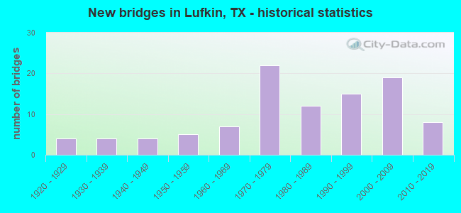
- New bridges - historical statistics
- 41920-1929
- 41930-1939
- 41940-1949
- 51950-1959
- 71960-1969
- 221970-1979
- 121980-1989
- 151990-1999
- 192000-2009
- 82010-2019

- Reconstructed bridges - Historical Statistics
- 31950-1959
- 61960-1969
- 11970-1979
- 31980-1989
- 01990-1999
- 22000-2009


- Bridge Condition - Deck
- 10.2%Very good
- 59.2%Good
- 28.6%Satisfactory
- 2.0%Fair

- Bridge Condition - Superstructure
- 20.4%Very good
- 49.0%Good
- 26.5%Satisfactory
- 2.0%Fair
- 2.0%Poor

- Bridge Condition - Substructure
- 8.2%Very good
- 61.2%Good
- 26.5%Satisfactory
- 4.1%Fair

- Bridge Condition - Channel
- 22.9%Good
- 62.5%Satisfactory
- 10.4%Fair
- 4.2%Poor

- Bridge Condition - Culverts
- 44.4%Good
- 51.9%Satisfactory
- 3.7%Fair
Find on map >> Show street view
Structure Number: 110030255301016, Location: AT US 59/SOUTH INTERCHANG (Lat: 31.309683, Lng: -94.726428), Route carried "under" structure: State highway 287, Year Built: 1988, Structure Length: 0. m, Average Daily Traffic: 45,660 (year 2010), Truck Traffic: 11%, Features Intersected: LP 287
Minimum Vertical Clearance: 5.39m (17.68ft), Kilometerpoint: 25.589, Lanes on structure: 1, Lanes under structure: 4, Material/Design: Prestressed concrete, Design/Construction: Box Beam or Girders - Multiple, Length of Maximum Span: 16.8m (55.1ft)
Find on map >> Show street view
Structure Number: 11003025530106, Location: 1.10 MI S OF SH 103 (Lat: 31.336911, Lng: -94.690653), Route carried "under" structure: State highway 325, Year Built: 1974, Structure Length: 0. m, Average Daily Traffic: 4,400 (year 2013), Truck Traffic: 25%, Features Intersected: LP 287, Facility Carried by Structure: LP 287
Minimum Vertical Clearance: 5.11m (16.77ft), Kilometerpoint: 4.218, Lanes on structure: 7, Material/Design: Prestressed concrete, Design/Construction: Stringer/Multi-beam, Length of Maximum Span: 30.5m (100.1ft)
Find on map >> Show street view
Structure Number: 110030255301081, Location: 1.1 MI W OF US 59 (Lat: 31.309158, Lng: -94.742497), Route carried "under" structure: State highway 324, Year Built: 1961, Structure Length: 0. m, Average Daily Traffic: 5,500 (year 2013), Truck Traffic: 25%, Features Intersected: FM 324 & SPRR, Facility Carried by Structure: LP 287
Minimum Vertical Clearance: 7.47m (24.51ft), Kilometerpoint: 3.661, Lanes on structure: 4, Lanes under structure: 4, Material/Design: Prestressed concrete, Design/Construction: Stringer/Multi-beam, Length of Maximum Span: 15.2m (49.9ft)
Find on map >> Show street view
Structure Number: 110030255301116, Location: 1.70 MI NE OF US 59 (Lat: 31.318844, Lng: -94.699911), Route carried "under" structure: Alternate State highway 69, Year Built: 1971, Structure Length: 0. m, Average Daily Traffic: 38,800 (year 2010), Truck Traffic: 11%, Features Intersected: LP 287 & U S59, Facility Carried by Structure: LP 287 & US 59
Minimum Vertical Clearance: 5.08m (16.67ft), Kilometerpoint: 22.711, Lanes on structure: 8, Material/Design: Prestressed concrete, Design/Construction: Stringer/Multi-beam, Length of Maximum Span: 25.9m (85.0ft)