Bridge Statistics for Marietta, Georgia (GA)
Condition, Traffic, Stress, Structural Evaluation, Project Costs
- National Bridge Inventory (NBI) Statistics
- 219Number of bridges
- 3,550ft / 1,082mTotal length
- $2,528,890,000Total costs
- 10,085,570Total average daily traffic
- 173,052Total average daily truck traffic
- National Bridge Inventory (NBI) Registered Bridges for Marietta
- No street view available for this location
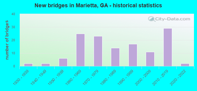
- New bridges - historical statistics
- 21930-1939
- 21940-1949
- 61950-1959
- 251960-1969
- 231970-1979
- 141980-1989
- 171990-1999
- 112000-2009
- 292010-2019
- 22020-2022

- Reconstructed bridges - Historical Statistics
- 41970-1979
- 101980-1989
- 101990-1999
- 12000-2009
- 22010-2019


- Bridge Condition - Deck
- 4.3%Very good
- 85.1%Good
- 9.6%Satisfactory
- 1.1%Fair

- Bridge Condition - Superstructure
- 26.6%Very good
- 72.3%Good
- 1.1%Satisfactory

- Bridge Condition - Substructure
- 11.7%Very good
- 84.0%Good
- 4.3%Satisfactory

- Bridge Condition - Channel
- 2.5%Excellent
- 24.1%Very good
- 58.2%Good
- 10.1%Satisfactory
- 3.8%Fair
- 1.3%Poor

- Bridge Condition - Culverts
- 5.4%Very good
- 83.8%Good
- 5.4%Satisfactory
- 5.4%Fair
Find on map >> Show street view
Structure Number: 675201, Location: 5.5 MI E OF KENNESAW (Lat: 34.035378, Lng: -84.520378), Route carried "on" structure: City street 9026, Year Built: 1999, Status: Open, Structure Length: 0.91m (2.99ft), Average Daily Traffic: 8,960 (year 2012), Truck Traffic: 1%, Average Future Daily Traffic: 13,440 (year 2032), Design Load: HS 20, Features Intersected: LITTLE NOONDAY CREEK, Facility Carried by Structure: BLACKWELL ROAD
Minimum Vertical Clearance: 30+ m (98+ ft), Kilometerpoint: 9.656, Lanes on structure: 2, Base Highway Network: Yes, Owner: County Highway Agency, Approaching Roadway Width: 8.2m (26.9ft), Skew: 9 degrees, Material/Design: Concrete, Design/Construction: Culvert, Number Of Spans In Main Unit: 3, Length of Maximum Span: 2.7m (8.9ft), Curb or Sidewalk Widths: Left: 1.5m (4.9ft), Right: 1.5m (4.9ft)
Condition: Channel: Very good, Culverts: Good, Operating Rating: 55.3 metric tons, Method Used To Determine Operating Rating: Field evaluation and documented engineering judgment, Inventory Rating: 32.6 metric tons, Method Used To Determine Inventory Rating: Field evaluation and documented engineering judgment, Structural Evaluation: Better than present minimum criteria, Waterway Adequacy: Equal to present desirable criteria, Approach Roadway Alignment: Equal to present desirable criteria, Designated Inspection Frequency: Every 24 months, Inspection Date: March 2021
Find on map >> Show street view
Structure Number: 675213, Location: 5.8 MI E OF KENNESAW (Lat: 34.025219, Lng: -84.514969), Route carried "on" structure: County highway 3091, Year Built: 1999, Status: Open, Structure Length: 0.73m (2.40ft), Average Daily Traffic: 1,930 (year 2012), Truck Traffic: 1%, Average Future Daily Traffic: 2,895 (year 2032), Design Load: HS 20, Features Intersected: LITTLE NOONDAY CREEK, Facility Carried by Structure: RIO MONTANA DRIVE
Minimum Vertical Clearance: 30+ m (98+ ft), Kilometerpoint: 0.000, Lanes on structure: 2, Base Highway Network: Yes, Owner: County Highway Agency, Approaching Roadway Width: 6.7m (22.0ft), Skew: 3 degrees, Material/Design: Concrete, Design/Construction: Culvert, Number Of Spans In Main Unit: 2, Length of Maximum Span: 3.7m (12.1ft)
Condition: Channel: Very good, Culverts: Good, Operating Rating: 55.3 metric tons, Method Used To Determine Operating Rating: Field evaluation and documented engineering judgment, Inventory Rating: 32.6 metric tons, Method Used To Determine Inventory Rating: Field evaluation and documented engineering judgment, Structural Evaluation: Better than present minimum criteria, Waterway Adequacy: Equal to present desirable criteria, Approach Roadway Alignment: Equal to present desirable criteria, Designated Inspection Frequency: Every 24 months, Inspection Date: April 2021, Bridge Improvement Cost: $94,000, Roadway Improvement Cost: $9,000, Total Project Cost: $141,000
Find on map >> Show street view
Structure Number: 675217, Location: 5.6 MI E OF MARIETTA (Lat: 33.968247, Lng: -84.455308), Route carried "on" structure: County highway 1327, Year Built: 1998, Status: Open, Structure Length: 1.86m (6.10ft), Average Daily Traffic: 1,930 (year 2012), Truck Traffic: 1%, Average Future Daily Traffic: 2,895 (year 2032), Design Load: HS 20+Mod, Features Intersected: SOPE CREEK, Facility Carried by Structure: ROBINSON ROAD
Minimum Vertical Clearance: 30+ m (98+ ft), Kilometerpoint: 3.219, Lanes on structure: 2, Base Highway Network: Yes, Owner: County Highway Agency, Approaching Roadway Width: 8.2m (26.9ft), Material/Design: Prestressed concrete, Design/Construction: Stringer/Multi-beam, Number Of Spans In Main Unit: 1, Length of Maximum Span: 18.6m (61.0ft), Curb or Sidewalk Widths: Left: 1.5m (4.9ft), Right: 1.5m (4.9ft), Curb-To-Curb Width: 8.2m (26.9ft), Out-to-Out Width: 12.0m (39.4ft)
Condition: Deck: Good, Superstructure: Very good, Substructure: Good, Channel: Good, Operating Rating: 46.2 metric tons, Method Used To Determine Operating Rating: Allowable Stress (AS), Inventory Rating: 32.6 metric tons, Method Used To Determine Inventory Rating: Allowable Stress (AS), Structural Evaluation: Better than present minimum criteria, Deck Geometry: Meets minimum limits, Waterway Adequacy: Equal to present desirable criteria, Approach Roadway Alignment: Equal to present desirable criteria, Designated Inspection Frequency: Every 24 months, Inspection Date: May 2021, Bridge Improvement Cost: $238,000, Roadway Improvement Cost: $24,000, Total Project Cost: $358,000, Deck Structure Type: Concrete Cast-file-Place
Find on map >> Show street view
Structure Number: 675232, Location: 3.2 MI S OF MARIETTA (Lat: 33.909208, Lng: -84.569208), Route carried "on" structure: County highway 957, Year Built: 2001, Status: Open, Structure Length: 1.04m (3.41ft), Average Daily Traffic: 1,930 (year 2012), Truck Traffic: 1%, Average Future Daily Traffic: 2,895 (year 2032), Design Load: HS 20, Features Intersected: OLLEY CREEK, Facility Carried by Structure: CUNNINGHAM ROAD
Minimum Vertical Clearance: 30+ m (98+ ft), Kilometerpoint: 1.609, Lanes on structure: 2, Base Highway Network: Yes, Owner: County Highway Agency, Approaching Roadway Width: 6.7m (22.0ft), Skew: 2 degrees, Material/Design: Concrete, Design/Construction: Culvert, Number Of Spans In Main Unit: 3, Length of Maximum Span: 3.4m (11.2ft), Curb or Sidewalk Widths: Left: 0.0m, Right: 1.5m (4.9ft)
Condition: Channel: Good, Culverts: Good, Operating Rating: 55.3 metric tons, Method Used To Determine Operating Rating: Field evaluation and documented engineering judgment, Inventory Rating: 32.6 metric tons, Method Used To Determine Inventory Rating: Field evaluation and documented engineering judgment, Structural Evaluation: Better than present minimum criteria, Waterway Adequacy: Better than present minimum criteria, Approach Roadway Alignment: Better than present minimum criteria, Designated Inspection Frequency: Every 24 months, Inspection Date: May 2021, Bridge Improvement Cost: $133,000, Roadway Improvement Cost: $13,000, Total Project Cost: $199,000
Find on map >> Show street view
Structure Number: 675233, Location: 4.1 MI W OF MARIETTA (Lat: 33.944819, Lng: -84.619558), Route carried "on" structure: County highway 944, Year Built: 2000, Status: Open, Structure Length: 1.37m (4.49ft), Average Daily Traffic: 1,930 (year 2012), Truck Traffic: 1%, Average Future Daily Traffic: 2,895 (year 2032), Design Load: HS 20+Mod, Features Intersected: NOSES CREEK, Facility Carried by Structure: OLD DALLAS ROAD
Minimum Vertical Clearance: 30+ m (98+ ft), Kilometerpoint: 1.609, Lanes on structure: 2, Base Highway Network: Yes, Owner: County Highway Agency, Approaching Roadway Width: 6.1m (20.0ft), Skew: 1 degrees, Material/Design: Concrete, Design/Construction: Culvert, Number Of Spans In Main Unit: 4, Length of Maximum Span: 3.0m (9.8ft), Curb or Sidewalk Widths: Left: 0.2m (0.7ft), Right: 0.0m
Condition: Channel: Good, Culverts: Good, Operating Rating: 55.3 metric tons, Method Used To Determine Operating Rating: Field evaluation and documented engineering judgment, Inventory Rating: 32.6 metric tons, Method Used To Determine Inventory Rating: Field evaluation and documented engineering judgment, Structural Evaluation: Better than present minimum criteria, Waterway Adequacy: Better than present minimum criteria, Approach Roadway Alignment: Equal to present desirable criteria, Designated Inspection Frequency: Every 24 months, Inspection Date: April 2021, Bridge Improvement Cost: $176,000, Roadway Improvement Cost: $18,000, Total Project Cost: $264,000
Find on map >> Show street view
Structure Number: 675239, Location: 4.8 MI SW OF MARIETTA (Lat: 33.923956, Lng: -84.629656), Route carried "on" structure: County highway 905, Year Built: 2002, Status: Open, Structure Length: 5.61m (18.41ft), Average Daily Traffic: 1,930 (year 2012), Truck Traffic: 1%, Average Future Daily Traffic: 2,895 (year 2032), Design Load: HS 20+Mod, Features Intersected: BARRETT PARKWAY, Facility Carried by Structure: IRWIN ROAD
Minimum Vertical Clearance: 30+ m (98+ ft), Kilometerpoint: 1.609, Lanes on structure: 2, Lanes under structure: 4, Base Highway Network: Yes, Owner: County Highway Agency, Approaching Roadway Width: 8.2m (26.9ft), Material/Design: Prestressed concrete, Design/Construction: Stringer/Multi-beam, Number Of Spans In Main Unit: 3, Length of Maximum Span: 34.4m (112.9ft), Curb or Sidewalk Widths: Left: 1.8m (5.9ft), Right: 1.8m (5.9ft), Curb-To-Curb Width: 8.5m (27.9ft), Out-to-Out Width: 12.8m (42.0ft)
Condition: Deck: Good, Superstructure: Very good, Substructure: Good, Operating Rating: 64.4 metric tons, Method Used To Determine Operating Rating: Load Factor (LF), Inventory Rating: 33.5 metric tons, Method Used To Determine Inventory Rating: Load Factor (LF), Structural Evaluation: Better than present minimum criteria, Deck Geometry: Somewhat better than minimum adequacy, Underclear: Superior to present desirable criteria, Approach Roadway Alignment: Equal to present desirable criteria, Designated Inspection Frequency: Every 24 months, Inspection Date: March 2021, Deck Structure Type: Concrete Cast-file-Place
Find on map >> Show street view
Structure Number: 67524, Location: 2 MILES SOUTH WEST OF MAR (Lat: 33.915469, Lng: -84.628239), Route carried "on" structure: County highway 8228, Year Built: 2000, Status: Open, Structure Length: 93.27m (306.00ft), Average Daily Traffic: 15,290 (year 2012), Truck Traffic: 1%, Average Future Daily Traffic: 22,935 (year 2032), Design Load: HS 20+Mod, Features Intersected: NOSES/WARD CREEKS, Facility Carried by Structure: BARRETT PARKWAY
Minimum Vertical Clearance: 30+ m (98+ ft), Kilometerpoint: 11.265, Lanes on structure: 4, Base Highway Network: Yes, Owner: County Highway Agency, Approaching Roadway Width: 18.3m (60.0ft), Skew: 30 degrees, Material/Design: Prestressed concrete, Design/Construction: Stringer/Multi-beam, Number Of Spans In Main Unit: 38, Length of Maximum Span: 36.6m (120.1ft), Curb-To-Curb Width: 23.6m (77.4ft), Out-to-Out Width: 25.3m (83.0ft)
Condition: Deck: Good, Superstructure: Good, Substructure: Good, Channel: Satisfactory, Operating Rating: 25.4 metric tons, Method Used To Determine Operating Rating: Load Factor (LF), Inventory Rating: 15.4 metric tons, Method Used To Determine Inventory Rating: Load Factor (LF), Structural Evaluation: High priority of corrective action, Deck Geometry: Superior to present desirable criteria, Waterway Adequacy: Equal to present desirable criteria, Approach Roadway Alignment: Equal to present desirable criteria, Designated Inspection Frequency: Every 24 months, Inspection Date: September 2021, Bridge Improvement Cost: $18,478,000, Roadway Improvement Cost: $1,848,000, Total Project Cost: $27,716,000, Deck Structure Type: Concrete Cast-file-Place
Find on map >> Show street view
Structure Number: 675245, Location: 3.8 MI E OF KENNESAW (Lat: 34.021578, Lng: -84.552289), Route carried "on" structure: County highway 3540, Year Built: 1999, Status: Open, Structure Length: 11.58m (37.99ft), Average Daily Traffic: 1,930 (year 2012), Truck Traffic: 1%, Average Future Daily Traffic: 2,895 (year 2032), Design Load: HS 20+Mod, Features Intersected: NOONDAY CREEK, Facility Carried by Structure: CHASTAIN MEADOWS P
Minimum Vertical Clearance: 30+ m (98+ ft), Kilometerpoint: 0.000, Lanes on structure: 4, Base Highway Network: Yes, Owner: County Highway Agency, Approaching Roadway Width: 15.8m (51.8ft), Skew: 24 degrees, Material/Design: Prestressed concrete, Design/Construction: Stringer/Multi-beam, Number Of Spans In Main Unit: 5, Length of Maximum Span: 23.2m (76.1ft), Curb or Sidewalk Widths: Left: 1.8m (5.9ft), Right: 1.8m (5.9ft), Curb-To-Curb Width: 20.7m (67.9ft), Out-to-Out Width: 25.3m (83.0ft)
Condition: Deck: Good, Superstructure: Very good, Substructure: Good, Channel: Good, Operating Rating: 66.2 metric tons, Method Used To Determine Operating Rating: Load Factor (LF), Inventory Rating: 30.8 metric tons, Method Used To Determine Inventory Rating: Load Factor (LF), Structural Evaluation: Better than present minimum criteria, Deck Geometry: Superior to present desirable criteria, Waterway Adequacy: Equal to present desirable criteria, Approach Roadway Alignment: Equal to present desirable criteria, Designated Inspection Frequency: Every 24 months, Inspection Date: April 2021, Bridge Improvement Cost: $2,295,000, Roadway Improvement Cost: $229,000, Total Project Cost: $3,442,000, Deck Structure Type: Concrete Cast-file-Place
Find on map >> Show street view
Structure Number: 675262, Location: 5 MILES NORTH EAST OF MAR (Lat: 33.990669, Lng: -84.477778), Route carried "on" structure: County highway 575, Year Built: 2009, Status: Open, Structure Length: 1.10m (3.61ft), Average Daily Traffic: 1,050 (year 2012), Truck Traffic: 1%, Average Future Daily Traffic: 1,575 (year 2032), Design Load: HS 20+Mod, Features Intersected: SEWELL CREEK TRIB., Facility Carried by Structure: HOLLY SPRINGS ROAD
Minimum Vertical Clearance: 30+ m (98+ ft), Kilometerpoint: 1.609, Lanes on structure: 2, Base Highway Network: Yes, Owner: County Highway Agency, Approaching Roadway Width: 7.0m (23.0ft), Material/Design: Concrete, Design/Construction: Culvert, Number Of Spans In Main Unit: 1, Length of Maximum Span: 11.0m (36.1ft)
Condition: Channel: Good, Culverts: Good, Operating Rating: 46.2 metric tons, Method Used To Determine Operating Rating: Field evaluation and documented engineering judgment, Inventory Rating: 32.6 metric tons, Method Used To Determine Inventory Rating: Field evaluation and documented engineering judgment, Structural Evaluation: Better than present minimum criteria, Waterway Adequacy: Better than present minimum criteria, Approach Roadway Alignment: Equal to present desirable criteria, Designated Inspection Frequency: Every 24 months, Inspection Date: May 2021, Bridge Improvement Cost: $141,000, Roadway Improvement Cost: $14,000, Total Project Cost: $211,000
Find on map >> Show street view
Structure Number: 675264, Location: 4.8 MLES SOUTH OF KENNESA (Lat: 33.953269, Lng: -84.612047), Route carried "on" structure: County highway 4431, Year Built: 2009, Status: Open, Structure Length: 1.83m (6.00ft), Average Daily Traffic: 11,820 (year 2012), Truck Traffic: 1%, Average Future Daily Traffic: 17,730 (year 2032), Design Load: HS 20+Mod, Features Intersected: NOSES CREEK, Facility Carried by Structure: MOUNT CALVARY ROAD
Minimum Vertical Clearance: 30+ m (98+ ft), Kilometerpoint: 1.609, Lanes on structure: 2, Base Highway Network: Yes, Owner: County Highway Agency, Approaching Roadway Width: 6.1m (20.0ft), Material/Design: Prestressed concrete, Design/Construction: Stringer/Multi-beam, Number Of Spans In Main Unit: 1, Length of Maximum Span: 18.3m (60.0ft), Curb-To-Curb Width: 12.2m (40.0ft), Out-to-Out Width: 13.2m (43.3ft)
Condition: Deck: Good, Superstructure: Very good, Substructure: Very good, Channel: Very good, Operating Rating: 68.0 metric tons, Method Used To Determine Operating Rating: Load Factor (LF), Inventory Rating: 41.7 metric tons, Method Used To Determine Inventory Rating: Load Factor (LF), Structural Evaluation: Equal to present desirable criteria, Deck Geometry: Somewhat better than minimum adequacy, Waterway Adequacy: Superior to present desirable criteria, Approach Roadway Alignment: Equal to present desirable criteria, Designated Inspection Frequency: Every 24 months, Inspection Date: May 2021, Bridge Improvement Cost: $234,000, Roadway Improvement Cost: $23,000, Total Project Cost: $352,000, Deck Structure Type: Concrete Cast-file-Place
Find on map >> Show street view
Structure Number: 675267, Location: 5.7 MI E OF KENNESAW (Lat: 34.031719, Lng: -84.518489), Route carried "on" structure: County highway 321, Year Built: 2008, Status: Open, Structure Length: 2.44m (8.01ft), Average Daily Traffic: 990 (year 2012), Truck Traffic: 1%, Average Future Daily Traffic: 1,485 (year 2032), Design Load: HS 20+Mod, Features Intersected: LITTLE NOONDAY CREEK, Facility Carried by Structure: WORLEY DRIVE
Minimum Vertical Clearance: 30+ m (98+ ft), Kilometerpoint: 1.609, Lanes on structure: 2, Base Highway Network: Yes, Owner: County Highway Agency, Approaching Roadway Width: 6.1m (20.0ft), Material/Design: Prestressed concrete, Design/Construction: Box Beam or Girders - Multiple, Number Of Spans In Main Unit: 2, Length of Maximum Span: 12.2m (40.0ft), Curb or Sidewalk Widths: Left: 1.5m (4.9ft), Right: 1.5m (4.9ft), Curb-To-Curb Width: 7.9m (25.9ft), Out-to-Out Width: 11.7m (38.4ft)
Condition: Deck: Good, Superstructure: Good, Substructure: Good, Channel: Good, Operating Rating: 46.2 metric tons, Method Used To Determine Operating Rating: Load Factor (LF), Inventory Rating: 27.2 metric tons, Method Used To Determine Inventory Rating: Load Factor (LF), Structural Evaluation: Equal to present minimum criteria, Deck Geometry: Somewhat better than minimum adequacy, Waterway Adequacy: Equal to present desirable criteria, Approach Roadway Alignment: Equal to present desirable criteria, Designated Inspection Frequency: Every 24 months, Inspection Date: April 2021, Bridge Improvement Cost: $313,000, Roadway Improvement Cost: $31,000, Total Project Cost: $469,000, Deck Structure Type: Concrete Precast Panels
Find on map >> Show street view
Structure Number: 67527, Location: 2.1 MI S OF MARIETTA (Lat: 33.923528, Lng: -84.558669), Route carried "on" structure: County highway 1083, Year Built: 2008, Status: Open, Structure Length: 1.83m (6.00ft), Average Daily Traffic: 1,930 (year 2012), Truck Traffic: 1%, Average Future Daily Traffic: 2,895 (year 2032), Design Load: HS 20+Mod, Features Intersected: OLLEY CREEK TRIB., Facility Carried by Structure: BOOTH ROAD
Minimum Vertical Clearance: 30+ m (98+ ft), Kilometerpoint: 0.000, Lanes on structure: 2, Base Highway Network: Yes, Owner: County Highway Agency, Approaching Roadway Width: 8.2m (26.9ft), Material/Design: Prestressed concrete, Design/Construction: Stringer/Multi-beam, Number Of Spans In Main Unit: 1, Length of Maximum Span: 18.3m (60.0ft), Curb or Sidewalk Widths: Left: 1.8m (5.9ft), Right: 1.8m (5.9ft), Curb-To-Curb Width: 8.5m (27.9ft), Out-to-Out Width: 12.9m (42.3ft)
Condition: Deck: Good, Superstructure: Very good, Substructure: Good, Channel: Good, Operating Rating: 76.2 metric tons, Method Used To Determine Operating Rating: Load Factor (LF), Inventory Rating: 34.4 metric tons, Method Used To Determine Inventory Rating: Load Factor (LF), Structural Evaluation: Better than present minimum criteria, Deck Geometry: Somewhat better than minimum adequacy, Waterway Adequacy: Equal to present desirable criteria, Approach Roadway Alignment: Equal to present desirable criteria, Designated Inspection Frequency: Every 24 months, Inspection Date: May 2021, Bridge Improvement Cost: $234,000, Roadway Improvement Cost: $23,000, Total Project Cost: $352,000, Deck Structure Type: Concrete Cast-file-Place
Find on map >> Show street view
Structure Number: 675275, Location: 6 MILES NE OF MARIETTA (Lat: 33.985603, Lng: -84.454719), Route carried "on" structure: County highway 1308, Year Built: 2010, Status: Open, Structure Length: 4.66m (15.29ft), Average Daily Traffic: 12,030 (year 2009), Truck Traffic: 1%, Average Future Daily Traffic: 14,680 (year 2029), Design Load: HS 20+Mod, Features Intersected: SEWEL CREEK, Facility Carried by Structure: SEWEL MILL ROAD
Minimum Vertical Clearance: 30+ m (98+ ft), Kilometerpoint: 1.609, Lanes on structure: 2, Owner: County Highway Agency, Approaching Roadway Width: 8.2m (26.9ft), Material/Design: Prestressed concrete, Design/Construction: Stringer/Multi-beam, Number Of Spans In Main Unit: 3, Length of Maximum Span: 15.5m (50.9ft), Curb or Sidewalk Widths: Left: 1.9m (6.2ft), Right: 1.9m (6.2ft), Curb-To-Curb Width: 8.2m (26.9ft), Out-to-Out Width: 12.7m (41.7ft)
Condition: Deck: Good, Superstructure: Very good, Substructure: Good, Channel: Good, Operating Rating: 78.9 metric tons, Method Used To Determine Operating Rating: Load Factor (LF), Inventory Rating: 61.6 metric tons, Method Used To Determine Inventory Rating: Load Factor (LF), Structural Evaluation: Better than present minimum criteria, Deck Geometry: High priority of replacement, Waterway Adequacy: Equal to present desirable criteria, Approach Roadway Alignment: Equal to present minimum criteria, Designated Inspection Frequency: Every 24 months, Inspection Date: September 2021, Bridge Improvement Cost: $598,000, Roadway Improvement Cost: $60,000, Total Project Cost: $897,000, Deck Structure Type: Concrete Cast-file-Place
Find on map >> Show street view
Structure Number: 675279, Location: IN NORTH WEST MARIETTA (Lat: 33.968897, Lng: -84.562683), Route carried "on" structure: City street 9024, Year Built: 2009, Status: Open, Structure Length: 1.28m (4.20ft), Average Daily Traffic: 6,670 (year 2011), Truck Traffic: 1%, Average Future Daily Traffic: 10,005 (year 2031), Design Load: HS 20+Mod, Features Intersected: NOSES CREEK, Facility Carried by Structure: KENNESAW AVENUE
Minimum Vertical Clearance: 30+ m (98+ ft), Kilometerpoint: 1.609, Lanes on structure: 2, Base Highway Network: Yes, Owner: City or Municipal Highway Agency, Approaching Roadway Width: 7.3m (24.0ft), Material/Design: Concrete, Design/Construction: Culvert, Number Of Spans In Main Unit: 1, Length of Maximum Span: 12.8m (42.0ft), Curb or Sidewalk Widths: Left: 1.5m (4.9ft), Right: 0.0m
Condition: Channel: Good, Culverts: Good, Operating Rating: 46.2 metric tons, Method Used To Determine Operating Rating: Field evaluation and documented engineering judgment, Inventory Rating: 32.6 metric tons, Method Used To Determine Inventory Rating: Field evaluation and documented engineering judgment, Structural Evaluation: Better than present minimum criteria, Waterway Adequacy: Equal to present desirable criteria, Approach Roadway Alignment: Equal to present desirable criteria, Designated Inspection Frequency: Every 24 months, Inspection Date: September 2021, Bridge Improvement Cost: $164,000, Roadway Improvement Cost: $16,000, Total Project Cost: $246,000
Find on map >> Show street view
Structure Number: 67528, Location: 3.7 MILES SOUTH WEST OF M (Lat: 33.920589, Lng: -84.601339), Route carried "on" structure: County highway 4394, Year Built: 2009, Status: Open, Structure Length: 1.55m (5.09ft), Average Daily Traffic: 1,940 (year 2011), Truck Traffic: 1%, Average Future Daily Traffic: 2,910 (year 2031), Design Load: H 15, Features Intersected: WARD CREEK, Facility Carried by Structure: CHEATHAM ROAD
Minimum Vertical Clearance: 30+ m (98+ ft), Kilometerpoint: 4.828, Lanes on structure: 2, Base Highway Network: Yes, Owner: County Highway Agency, Approaching Roadway Width: 7.0m (23.0ft), Material/Design: Prestressed concrete, Design/Construction: Channel Beam, Number Of Spans In Main Unit: 2, Length of Maximum Span: 11.0m (36.1ft), Curb-To-Curb Width: 10.0m (32.8ft), Out-to-Out Width: 13.7m (44.9ft)
Condition: Deck: Good, Superstructure: Good, Substructure: Good, Channel: Satisfactory, Operating Rating: 42.6 metric tons, Method Used To Determine Operating Rating: Load Factor (LF), Inventory Rating: 25.4 metric tons, Method Used To Determine Inventory Rating: Load Factor (LF), Structural Evaluation: Equal to present minimum criteria, Deck Geometry: Somewhat better than minimum adequacy, Waterway Adequacy: Equal to present minimum criteria, Approach Roadway Alignment: Equal to present desirable criteria, Designated Inspection Frequency: Every 24 months, Inspection Date: September 2021, Bridge Improvement Cost: $199,000, Roadway Improvement Cost: $20,000, Total Project Cost: $299,000, Deck Structure Type: Concrete Precast Panels, Wearing Surface/Protective System: Wearing Surface: Bituminous
Find on map >> Show street view
Structure Number: 675281, Location: 5.4 MILES WEST OF MARIETT (Lat: 33.935597, Lng: -84.640836), Route carried "on" structure: County highway 914, Year Built: 2010, Status: Open, Structure Length: 0.85m (2.79ft), Average Daily Traffic: 4,150 (year 2011), Truck Traffic: 1%, Average Future Daily Traffic: 6,225 (year 2031), Design Load: HS 20+Mod, Features Intersected: MUD CREEK, Facility Carried by Structure: WEST SANDTOWN ROAD
Minimum Vertical Clearance: 30+ m (98+ ft), Kilometerpoint: 4.828, Lanes on structure: 2, Base Highway Network: Yes, Owner: County Highway Agency, Approaching Roadway Width: 6.1m (20.0ft), Skew: 1 degrees, Material/Design: Concrete, Design/Construction: Culvert, Number Of Spans In Main Unit: 1, Length of Maximum Span: 8.5m (27.9ft), Curb or Sidewalk Widths: Left: 1.5m (4.9ft), Right: 1.5m (4.9ft)
Condition: Channel: Good, Culverts: Good, Operating Rating: 46.2 metric tons, Method Used To Determine Operating Rating: Field evaluation and documented engineering judgment, Inventory Rating: 32.6 metric tons, Method Used To Determine Inventory Rating: Field evaluation and documented engineering judgment, Structural Evaluation: Better than present minimum criteria, Waterway Adequacy: Equal to present desirable criteria, Approach Roadway Alignment: Equal to present desirable criteria, Designated Inspection Frequency: Every 24 months, Inspection Date: September 2021, Bridge Improvement Cost: $109,000, Roadway Improvement Cost: $11,000, Total Project Cost: $164,000
Find on map >> Show street view
Structure Number: 675295, Location: 4 MILES E. OF KENNESAW (Lat: 34.021436, Lng: -84.544117), Route carried "on" structure: County highway 239, Year Built: 2009, Status: Open, Structure Length: 3.05m (10.01ft), Average Daily Traffic: 1,930 (year 2012), Truck Traffic: 1%, Average Future Daily Traffic: 2,895 (year 2032), Design Load: HS 20+Mod, Features Intersected: NOONDAY CREEK TRIB, Facility Carried by Structure: ROCK BRIDGE ROAD
Minimum Vertical Clearance: 30+ m (98+ ft), Kilometerpoint: 0.000, Lanes on structure: 2, Base Highway Network: Yes, Owner: County Highway Agency, Approaching Roadway Width: 8.2m (26.9ft), Material/Design: Prestressed concrete, Design/Construction: Box Beam or Girders - Multiple, Number Of Spans In Main Unit: 3, Length of Maximum Span: 12.2m (40.0ft), Curb or Sidewalk Widths: Left: 1.8m (5.9ft), Right: 1.8m (5.9ft), Curb-To-Curb Width: 7.8m (25.6ft), Out-to-Out Width: 12.2m (40.0ft)
Condition: Deck: Very good, Superstructure: Very good, Substructure: Good, Channel: Very good, Operating Rating: 40.8 metric tons, Method Used To Determine Operating Rating: Load Factor (LF), Inventory Rating: 24.4 metric tons, Method Used To Determine Inventory Rating: Load Factor (LF), Structural Evaluation: Equal to present minimum criteria, Deck Geometry: Meets minimum limits, Waterway Adequacy: Superior to present desirable criteria, Approach Roadway Alignment: Better than present minimum criteria, Designated Inspection Frequency: Every 24 months, Inspection Date: August 2021, Bridge Improvement Cost: $391,000, Roadway Improvement Cost: $39,000, Total Project Cost: $586,000, Deck Structure Type: Concrete Precast Panels, Wearing Surface/Protective System: Wearing Surface: Bituminous
Find on map >> Show street view
Structure Number: 675296, Location: 3 MILES WEST OF SYMRNA (Lat: 33.895769, Lng: -84.586806), Route carried "on" structure: County highway 9001, Year Built: 2010, Status: Open, Structure Length: 15.48m (50.79ft), Average Daily Traffic: 1,930 (year 2012), Truck Traffic: 1%, Average Future Daily Traffic: 2,895 (year 2032), Design Load: HS 20+Mod, Features Intersected: OLLEY CREEK, Facility Carried by Structure: WINDY HILL/MACLAND
Minimum Vertical Clearance: 30+ m (98+ ft), Kilometerpoint: 1.609, Lanes on structure: 4, Base Highway Network: Yes, Owner: County Highway Agency, Approaching Roadway Width: 17.7m (58.1ft), Skew: 11 degrees, Material/Design: Prestressed concrete, Design/Construction: Stringer/Multi-beam, Number Of Spans In Main Unit: 4, Length of Maximum Span: 41.5m (136.2ft), Curb-To-Curb Width: 21.9m (71.9ft), Out-to-Out Width: 23.0m (75.5ft)
Condition: Deck: Good, Superstructure: Good, Substructure: Good, Channel: Very good, Operating Rating: 83.4 metric tons, Method Used To Determine Operating Rating: Load Factor (LF), Inventory Rating: 39.9 metric tons, Method Used To Determine Inventory Rating: Load Factor (LF), Structural Evaluation: Better than present minimum criteria, Deck Geometry: Superior to present desirable criteria, Waterway Adequacy: Equal to present desirable criteria, Approach Roadway Alignment: Equal to present desirable criteria, Designated Inspection Frequency: Every 24 months, Inspection Date: September 2021, Bridge Improvement Cost: $3,068,000, Roadway Improvement Cost: $307,000, Total Project Cost: $4,601,000, Deck Structure Type: Concrete Cast-file-Place
Find on map >> Show street view
Structure Number: 675297, Location: 3.6 MILES WEST OF SYMRNA (Lat: 33.896531, Lng: -84.591217), Route carried "on" structure: County highway 4394, Year Built: 2010, Status: Open, Structure Length: 4.08m (13.39ft), Average Daily Traffic: 1,930 (year 2012), Truck Traffic: 1%, Average Future Daily Traffic: 2,895 (year 2032), Design Load: HS 20+Mod, Features Intersected: WINDY HILL/MACLAND CONN., Facility Carried by Structure: CALLAWAY ROAD
Minimum Vertical Clearance: 30+ m (98+ ft), Kilometerpoint: 0.000, Lanes on structure: 5, Lanes under structure: 4, Base Highway Network: Yes, Owner: County Highway Agency, Approaching Roadway Width: 7.3m (24.0ft), Skew: 25 degrees, Material/Design: Prestressed concrete, Design/Construction: Stringer/Multi-beam, Number Of Spans In Main Unit: 2, Length of Maximum Span: 20.4m (66.9ft), Curb or Sidewalk Widths: Left: 1.8m (5.9ft), Right: 3.0m (9.8ft), Curb-To-Curb Width: 13.4m (44.0ft), Out-to-Out Width: 27.1m (88.9ft)
Condition: Deck: Good, Superstructure: Good, Substructure: Very good, Operating Rating: 78.9 metric tons, Method Used To Determine Operating Rating: Load Factor (LF), Inventory Rating: 48.0 metric tons, Method Used To Determine Inventory Rating: Load Factor (LF), Structural Evaluation: Better than present minimum criteria, Deck Geometry: High priority of replacement, Underclear: Meets minimum limits, Approach Roadway Alignment: Equal to present desirable criteria, Designated Inspection Frequency: Every 24 months, Inspection Date: September 2021, Bridge Improvement Cost: $952,000, Roadway Improvement Cost: $95,000, Total Project Cost: $1,428,000, Deck Structure Type: Concrete Cast-file-Place
Find on map >> Show street view
Structure Number: 675301, Location: 3 MILES EAST OF MARIETTA (Lat: 33.997772, Lng: -84.541050), Route carried "on" structure: County highway 1044, Year Built: 2012, Status: Open, Structure Length: 0.73m (2.40ft), Average Daily Traffic: 200 (year 2012), Truck Traffic: 1%, Average Future Daily Traffic: 300 (year 2032), Design Load: HS 20+Mod, Features Intersected: NOONDAY CREEK TRIB., Facility Carried by Structure: MARK AVENUE
Minimum Vertical Clearance: 30+ m (98+ ft), Kilometerpoint: 0.000, Lanes on structure: 2, Owner: County Highway Agency, Approaching Roadway Width: 6.1m (20.0ft), Material/Design: Concrete, Design/Construction: Culvert, Number Of Spans In Main Unit: 2, Length of Maximum Span: 3.0m (9.8ft)
Condition: Channel: Very good, Culverts: Very good, Operating Rating: 41.7 metric tons, Method Used To Determine Operating Rating: Field evaluation and documented engineering judgment, Inventory Rating: 24.4 metric tons, Method Used To Determine Inventory Rating: Field evaluation and documented engineering judgment, Structural Evaluation: Equal to present minimum criteria, Waterway Adequacy: Equal to present desirable criteria, Approach Roadway Alignment: Equal to present desirable criteria, Designated Inspection Frequency: Every 24 months, Inspection Date: September 2021, Bridge Improvement Cost: $94,000, Roadway Improvement Cost: $9,000, Total Project Cost: $141,000
Find on map >> Show street view
Structure Number: 675302, Location: IN EAST MARIETTA (Lat: 33.960350, Lng: -84.497256), Route carried "on" structure: State highway 120, Year Built: 2012, Status: Open, Structure Length: 6.40m (21.00ft), Average Daily Traffic: 20,220 (year 2013), Truck Traffic: 2%, Average Future Daily Traffic: 20,220 (year 2030), Design Load: HS 20+Mod, Features Intersected: SR120
Minimum Vertical Clearance: 30+ m (98+ ft), Kilometerpoint: 3.219, Lanes on structure: 2, Lanes under structure: 7, Owner: State Highway Agency, Approaching Roadway Width: 8.5m (27.9ft), Skew: 11 degrees, Material/Design: Prestressed concrete, Design/Construction: Stringer/Multi-beam, Number Of Spans In Main Unit: 2, Length of Maximum Span: 32.0m (105.0ft), Curb-To-Curb Width: 12.2m (40.0ft), Out-to-Out Width: 13.2m (43.3ft)
Condition: Deck: Good, Superstructure: Very good, Substructure: Good, Operating Rating: 64.4 metric tons, Method Used To Determine Operating Rating: Load Factor (LF), Inventory Rating: 39.0 metric tons, Method Used To Determine Inventory Rating: Load Factor (LF), Structural Evaluation: Better than present minimum criteria, Deck Geometry: Better than present minimum criteria, Underclear: High priority of corrective action, Approach Roadway Alignment: Equal to present minimum criteria, Designated Inspection Frequency: Every 24 months, Inspection Date: March 2021, Deck Structure Type: Concrete Cast-file-Place
Find on map >> Show street view
Structure Number: 675311, Location: 6.5 E OF MARIETTA (Lat: 33.940858, Lng: -84.437539), Route carried "on" structure: County highway 1139, Year Built: 2013, Status: Open, Structure Length: 3.84m (12.60ft), Average Daily Traffic: 8,162 (year 2013), Truck Traffic: 7%, Average Future Daily Traffic: 10,993 (year 2033), Design Load: HS 20, Features Intersected: SOPE CREEK, Facility Carried by Structure: PAPER MILL ROAD
Minimum Vertical Clearance: 30+ m (98+ ft), Kilometerpoint: 3.219, Lanes on structure: 2, Base Highway Network: Yes, Owner: County Highway Agency, Approaching Roadway Width: 6.1m (20.0ft), Skew: 3 degrees, Material/Design: Prestressed concrete, Design/Construction: Stringer/Multi-beam, Number Of Spans In Main Unit: 1, Length of Maximum Span: 38.4m (126.0ft), Curb or Sidewalk Widths: Left: 0.0m, Right: 1.8m (5.9ft), Curb-To-Curb Width: 10.4m (34.1ft), Out-to-Out Width: 13.4m (44.0ft)
Condition: Deck: Good, Superstructure: Very good, Substructure: Very good, Channel: Very good, Operating Rating: 89.8 metric tons, Method Used To Determine Operating Rating: Load Factor (LF), Inventory Rating: 54.4 metric tons, Method Used To Determine Inventory Rating: Load Factor (LF), Structural Evaluation: Equal to present desirable criteria, Deck Geometry: Meets minimum limits, Waterway Adequacy: Equal to present desirable criteria, Approach Roadway Alignment: High priority of replacement, Length Of Structure Improvement: 4.61m (15.12ft), Designated Inspection Frequency: Every 24 months, Inspection Date: August 2021, Bridge Improvement Cost: $11,188,000, Roadway Improvement Cost: $1,118,000, Total Project Cost: $16,783,000, Deck Structure Type: Concrete Cast-file-Place
Find on map >> Show street view
Structure Number: 675314, Location: 1.6 MI N OF MARIETTA (Lat: 33.976269, Lng: -84.547389), Route carried "on" structure: City street 9004, Year Built: 2013, Status: Open, Structure Length: 4.57m (14.99ft), Average Daily Traffic: 9,540 (year 2015), Truck Traffic: 1%, Average Future Daily Traffic: 14,310 (year 2032), Design Load: HS 20, Features Intersected: SR 3 (US 41), Facility Carried by Structure: CANTON ROAD
Minimum Vertical Clearance: 30+ m (98+ ft), Kilometerpoint: 1.609, Lanes on structure: 2, Lanes under structure: 6, Base Highway Network: Yes, Owner: State Highway Agency, Approaching Roadway Width: 7.3m (24.0ft), Material/Design: Prestressed concrete, Design/Construction: Stringer/Multi-beam, Number Of Spans In Main Unit: 1, Length of Maximum Span: 45.7m (149.9ft), Curb or Sidewalk Widths: Left: 0.2m (0.7ft), Right: 0.2m (0.7ft), Curb-To-Curb Width: 12.2m (40.0ft), Out-to-Out Width: 16.8m (55.1ft)
Condition: Deck: Good, Superstructure: Very good, Substructure: Very good, Inventory Rating: 40.8 metric tons, Method Used To Determine Inventory Rating: Load Factor (LF), Structural Evaluation: Equal to present desirable criteria, Deck Geometry: Somewhat better than minimum adequacy, Underclear: High priority of replacement, Approach Roadway Alignment: Equal to present minimum criteria, Length Of Structure Improvement: 5.49m (18.01ft), Designated Inspection Frequency: Every 24 months, Inspection Date: April 2021, Bridge Improvement Cost: $13,320,000, Roadway Improvement Cost: $1,332,000, Total Project Cost: $19,980,000 ( Estimate for 2015), Deck Structure Type: Concrete Cast-file-Place
Find on map >> Show street view
Structure Number: 675318, Location: 4 MI SOUTH OF KENNESAW (Lat: 33.966639, Lng: -84.626478), Route carried "on" structure: County highway 858, Year Built: 2014, Status: Open, Structure Length: 2.44m (8.01ft), Average Daily Traffic: 1,930 (year 2012), Truck Traffic: 1%, Average Future Daily Traffic: 2,895 (year 2032), Design Load: HS 20, Features Intersected: MUD CREEK, Facility Carried by Structure: BURNT HICKORY RD
Minimum Vertical Clearance: 30+ m (98+ ft), Kilometerpoint: 1.609, Lanes on structure: 2, Base Highway Network: Yes, Owner: County Highway Agency, Approaching Roadway Width: 9.8m (32.2ft), Material/Design: Concrete, Design/Construction: Box Beam or Girders - Multiple, Number Of Spans In Main Unit: 3, Length of Maximum Span: 12.2m (40.0ft), Curb or Sidewalk Widths: Left: 1.7m (5.6ft), Right: 1.7m (5.6ft), Curb-To-Curb Width: 8.8m (28.9ft), Out-to-Out Width: 13.7m (44.9ft)
Condition: Deck: Good, Superstructure: Very good, Substructure: Very good, Channel: Very good, Operating Rating: 83.4 metric tons, Method Used To Determine Operating Rating: Load Factor (LF), Inventory Rating: 49.8 metric tons, Method Used To Determine Inventory Rating: Load Factor (LF), Structural Evaluation: Equal to present desirable criteria, Deck Geometry: Somewhat better than minimum adequacy, Waterway Adequacy: Equal to present desirable criteria, Approach Roadway Alignment: Equal to present desirable criteria, Length Of Structure Improvement: 2.93m (9.61ft), Designated Inspection Frequency: Every 24 months, Inspection Date: August 2021, Bridge Improvement Cost: $7,104,000, Roadway Improvement Cost: $710,000, Total Project Cost: $10,656,000 ( Estimate for 2015), Deck Structure Type: Concrete Precast Panels
Find on map >> Show street view
Structure Number: 67532, Location: IN NORTH MARIETTA (Lat: 33.981367, Lng: -84.539900), Route carried "on" structure: Alternate Interstate 75, Year Built: 2016, Status: Open, Structure Length: 178.58m (585.89ft), Average Daily Traffic: 9,999 (year 2016), Average Future Daily Traffic: 9,999 (year 2036), Design Load: HS 20+Mod, Features Intersected: SR 5-CANTON RD-GA NE RR
Minimum Vertical Clearance: 30+ m (98+ ft), Kilometerpoint: 428.086, Lanes on structure: 2, Lanes under structure: 8, Base Highway Network: Yes, Toll: On toll road, Owner: State Highway Agency, Approaching Roadway Width: 7.3m (24.0ft), Material/Design: Prestressed concrete, Design/Construction: Stringer/Multi-beam, Number Of Spans In Main Unit: 45, Length of Maximum Span: 43.3m (142.1ft), Curb-To-Curb Width: 11.0m (36.1ft), Out-to-Out Width: 11.9m (39.0ft)
Condition: Deck: Good, Superstructure: Good, Substructure: Good, Operating Rating: 89.8 metric tons, Method Used To Determine Operating Rating: Load Factor (LF), Inventory Rating: 28.1 metric tons, Method Used To Determine Inventory Rating: Load Factor (LF), Structural Evaluation: Better than present minimum criteria, Approach Roadway Alignment: Equal to present desirable criteria, Length Of Structure Improvement: 214.27m (702.99ft), Designated Inspection Frequency: Every 24 months, Inspection Date: Febuary 2022, Bridge Improvement Cost: $520,220,000, Roadway Improvement Cost: $52,022,000, Total Project Cost: $780,330,000 ( Estimate for 2016), Deck Structure Type: Concrete Cast-file-Place
Find on map >> Show street view
Structure Number: 675321, Location: NEAR KENNESAW (Lat: 34.009450, Lng: -84.567481), Route carried "on" structure: Alternate Interstate 401, Year Built: 2016, Status: Open, Structure Length: 45.29m (148.59ft), Average Daily Traffic: 9,999 (year 2016), Average Future Daily Traffic: 8,030 (year 2035), Design Load: HS 20+Mod, Features Intersected: I-75 SBL - I-75 RAMP - B, Facility Carried by Structure: I-75 MANAGED LANES
Minimum Vertical Clearance: 30+ m (98+ ft), Kilometerpoint: 432.914, Lanes on structure: 1, Lanes under structure: 14, Toll: On toll road, Owner: State Highway Agency, Approaching Roadway Width: 7.3m (24.0ft), Material/Design: Prestressed concrete, Design/Construction: Stringer/Multi-beam, Number Of Spans In Main Unit: 11, Length of Maximum Span: 55.5m (182.1ft), Curb-To-Curb Width: 7.9m (25.9ft), Out-to-Out Width: 8.9m (29.2ft)
Condition: Deck: Good, Superstructure: Good, Substructure: Good, Operating Rating: 73.4 metric tons, Method Used To Determine Operating Rating: Load Factor (LF), Inventory Rating: 7.2 metric tons, Method Used To Determine Inventory Rating: Load Factor (LF), Structural Evaluation: High priority of corrective action, Deck Geometry: High priority of corrective action, Underclear: High priority of corrective action, Approach Roadway Alignment: Equal to present desirable criteria, Length Of Structure Improvement: 54.35m (178.31ft), Designated Inspection Frequency: Every 24 months, Inspection Date: Febuary 2022, Bridge Improvement Cost: $131,942,000, Roadway Improvement Cost: $13,194,000, Total Project Cost: $197,913,000 ( Estimate for 2016), Deck Structure Type: Concrete Cast-file-Place
Find on map >> Show street view
Structure Number: 675322, Location: 3 MI E OF KENNESAW (Lat: 34.014097, Lng: -84.558781), Route carried "on" structure: Alternate Interstate 417, Year Built: 2016, Status: Open, Structure Length: 6.28m (20.60ft), Average Daily Traffic: 9,999 (year 2016), Average Future Daily Traffic: 9,999 (year 2036), Design Load: HS 20+Mod, Features Intersected: SR 5C ERNEST BARRETT PKW, Facility Carried by Structure: I-575 MANAGED LANE
Minimum Vertical Clearance: 30+ m (98+ ft), Kilometerpoint: 1.609, Lanes on structure: 2, Lanes under structure: 8, Base Highway Network: Yes, Toll: On toll road, Owner: State Highway Agency, Approaching Roadway Width: 7.3m (24.0ft), Material/Design: Prestressed concrete, Design/Construction: Stringer/Multi-beam, Number Of Spans In Main Unit: 11, Length of Maximum Span: 32.9m (107.9ft), Curb-To-Curb Width: 7.9m (25.9ft), Out-to-Out Width: 8.9m (29.2ft)
Condition: Deck: Good, Superstructure: Very good, Substructure: Good, Operating Rating: 81.6 metric tons, Method Used To Determine Operating Rating: Load Factor (LF), Inventory Rating: 39.0 metric tons, Method Used To Determine Inventory Rating: Load Factor (LF), Structural Evaluation: Better than present minimum criteria, Underclear: High priority of corrective action, Approach Roadway Alignment: Equal to present desirable criteria, Length Of Structure Improvement: 7.53m (24.70ft), Designated Inspection Frequency: Every 24 months, Inspection Date: Febuary 2022, Bridge Improvement Cost: $18,278,000, Roadway Improvement Cost: $1,828,000, Total Project Cost: $27,417,000 ( Estimate for 2016), Deck Structure Type: Concrete Cast-file-Place
Find on map >> Show street view
Structure Number: 675323, Location: 3 MI E OF KENNESAW (Lat: 34.024917, Lng: -84.559881), Route carried "on" structure: Alternate Interstate 417, Year Built: 2016, Status: Open, Structure Length: 5.18m (16.99ft), Average Daily Traffic: 9,999 (year 2016), Average Future Daily Traffic: 9,999 (year 2036), Design Load: HS 20+Mod, Features Intersected: NOONDAY CREEK, Facility Carried by Structure: I-575 MANAGED LANE
Minimum Vertical Clearance: 30+ m (98+ ft), Kilometerpoint: 3.219, Lanes on structure: 2, Base Highway Network: Yes, Toll: On toll road, Owner: State Highway Agency, Approaching Roadway Width: 7.3m (24.0ft), Material/Design: Prestressed concrete, Design/Construction: Stringer/Multi-beam, Number Of Spans In Main Unit: 11, Length of Maximum Span: 51.8m (169.9ft), Curb-To-Curb Width: 7.9m (25.9ft), Out-to-Out Width: 8.9m (29.2ft)
Condition: Deck: Good, Superstructure: Good, Substructure: Very good, Channel: Very good, Inventory Rating: 45.3 metric tons, Method Used To Determine Inventory Rating: Load Factor (LF), Structural Evaluation: Better than present minimum criteria, Waterway Adequacy: Superior to present desirable criteria, Approach Roadway Alignment: Equal to present desirable criteria, Length Of Structure Improvement: 6.22m (20.41ft), Designated Inspection Frequency: Every 24 months, Inspection Date: Febuary 2022, Bridge Improvement Cost: $15,096,000, Roadway Improvement Cost: $1,510,000, Total Project Cost: $22,644,000 ( Estimate for 2016), Deck Structure Type: Concrete Cast-file-Place
Find on map >> Show street view
Structure Number: 67533, Location: IN EAST MARIETTA (Lat: 33.961394, Lng: -84.520925), Route carried "on" structure: Interstate 75, Year Built: 2018, Status: Open, Structure Length: 13.38m (43.90ft), Average Daily Traffic: 225,340 (year 2012), Average Future Daily Traffic: 338,010 (year 2032), Design Load: HS 20+Mod, Features Intersected: NORTH MARIETTA PARKWAY
Minimum Vertical Clearance: 30+ m (98+ ft), Kilometerpoint: 426.476, Lanes on structure: 2, Lanes under structure: 5, Base Highway Network: Yes, Toll: On toll road, Owner: State Highway Agency, Approaching Roadway Width: 11.0m (36.1ft), Material/Design: Prestressed concrete, Design/Construction: Stringer/Multi-beam, Number Of Spans In Main Unit: 4, Length of Maximum Span: 44.2m (145.0ft), Curb-To-Curb Width: 11.0m (36.1ft), Out-to-Out Width: 11.9m (39.0ft)
Condition: Deck: Good, Superstructure: Good, Substructure: Good, Operating Rating: 59.8 metric tons, Method Used To Determine Operating Rating: Load Factor (LF), Inventory Rating: 35.3 metric tons, Method Used To Determine Inventory Rating: Load Factor (LF), Structural Evaluation: Better than present minimum criteria, Underclear: Somewhat better than minimum adequacy, Approach Roadway Alignment: Equal to present desirable criteria, Length Of Structure Improvement: 16.06m (52.69ft), Designated Inspection Frequency: Every 24 months, Inspection Date: Febuary 2022, Bridge Improvement Cost: $38,998,000, Roadway Improvement Cost: $3,900,000, Total Project Cost: $58,497,000 ( Estimate for 2018), Deck Structure Type: Concrete Cast-file-Place
Find on map >> Show street view
Structure Number: 675337, Location: 2.7 MILES NORTH EAST OF S (Lat: 33.903100, Lng: -84.474900), Route carried "on" structure: Ramp Interstate 75, Year Built: 2018, Status: Open, Structure Length: 4.45m (14.60ft), Average Daily Traffic: 999 (year 2018), Truck Traffic: 1%, Average Future Daily Traffic: 9,999 (year 2050), Design Load: HS 20+Mod, Features Intersected: I-75 MANAGED LANES
Minimum Vertical Clearance: 30+ m (98+ ft), Kilometerpoint: 418.430, Lanes on structure: 2, Lanes under structure: 2, Owner: State Highway Agency, Approaching Roadway Width: 11.6m (38.1ft), Material/Design: Prestressed concrete, Design/Construction: Stringer/Multi-beam, Number Of Spans In Main Unit: 1, Length of Maximum Span: 44.5m (146.0ft), Curb-To-Curb Width: 11.3m (37.1ft), Out-to-Out Width: 12.7m (41.7ft)
Condition: Deck: Good, Superstructure: Very good, Substructure: Very good, Operating Rating: 72.5 metric tons, Method Used To Determine Operating Rating: Load Factor (LF), Inventory Rating: 38.1 metric tons, Method Used To Determine Inventory Rating: Load Factor (LF), Structural Evaluation: Equal to present desirable criteria, Deck Geometry: Superior to present desirable criteria, Underclear: High priority of corrective action, Approach Roadway Alignment: Equal to present desirable criteria, Length Of Structure Improvement: 5.33m (17.49ft), Designated Inspection Frequency: Every 24 months, Inspection Date: Febuary 2022, Bridge Improvement Cost: $12,965,000, Roadway Improvement Cost: $1,296,000, Total Project Cost: $19,447,000 ( Estimate for 2018), Deck Structure Type: Concrete Cast-file-Place
Find on map >> Show street view
Structure Number: 675338, Location: IN EAST MARIETTA (Lat: 33.922281, Lng: -84.485747), Route carried "on" structure: Interstate 75, Year Built: 2017, Status: Open, Structure Length: 70.44m (231.10ft), Average Daily Traffic: 6,650 (year 2018), Average Future Daily Traffic: 18,520 (year 2035), Design Load: HS 20+Mod, Features Intersected: SR 280 DELK ROAD
Minimum Vertical Clearance: 30+ m (98+ ft), Kilometerpoint: 420.039, Lanes on structure: 2, Lanes under structure: 11, Base Highway Network: Yes, Toll: On toll road, Owner: State Highway Agency, Approaching Roadway Width: 10.9m (35.8ft), Material/Design: Prestressed concrete, Design/Construction: Stringer/Multi-beam, Number Of Spans In Main Unit: 17, Length of Maximum Span: 47.2m (154.9ft), Curb-To-Curb Width: 11.0m (36.1ft), Out-to-Out Width: 11.9m (39.0ft)
Condition: Deck: Good, Superstructure: Good, Substructure: Good, Operating Rating: 67.1 metric tons, Method Used To Determine Operating Rating: Load Factor (LF), Inventory Rating: 32.6 metric tons, Method Used To Determine Inventory Rating: Load Factor (LF), Structural Evaluation: Better than present minimum criteria, Underclear: Meets minimum limits, Approach Roadway Alignment: Equal to present desirable criteria, Length Of Structure Improvement: 84.52m (277.30ft), Designated Inspection Frequency: Every 24 months, Inspection Date: Febuary 2022, Bridge Improvement Cost: $205,217,000, Roadway Improvement Cost: $20,522,000, Total Project Cost: $307,826,000 ( Estimate for 2018), Deck Structure Type: Concrete Cast-file-Place
Find on map >> Show street view
Structure Number: 675339, Location: IN EAST MARIETTA (Lat: 33.928617, Lng: -84.489147), Route carried "on" structure: Interstate 75, Year Built: 2017, Status: Open, Structure Length: 38.95m (127.79ft), Average Daily Traffic: 6,650 (year 2018), Average Future Daily Traffic: 18,520 (year 2035), Design Load: HS 20+Mod, Features Intersected: ROTTENWOOD CREEK
Minimum Vertical Clearance: 30+ m (98+ ft), Kilometerpoint: 421.648, Lanes on structure: 2, Base Highway Network: Yes, Toll: On toll road, Owner: State Highway Agency, Approaching Roadway Width: 10.8m (35.4ft), Material/Design: Prestressed concrete, Design/Construction: Stringer/Multi-beam, Number Of Spans In Main Unit: 9, Length of Maximum Span: 43.3m (142.1ft), Curb-To-Curb Width: 11.0m (36.1ft), Out-to-Out Width: 11.9m (39.0ft)
Condition: Deck: Good, Superstructure: Good, Substructure: Good, Channel: Good, Operating Rating: 86.1 metric tons, Method Used To Determine Operating Rating: Load Factor (LF), Inventory Rating: 37.1 metric tons, Method Used To Determine Inventory Rating: Load Factor (LF), Structural Evaluation: Better than present minimum criteria, Waterway Adequacy: Superior to present desirable criteria, Approach Roadway Alignment: Equal to present desirable criteria, Length Of Structure Improvement: 46.76m (153.41ft), Designated Inspection Frequency: Every 24 months, Inspection Date: Febuary 2022, Bridge Improvement Cost: $113,486,000, Roadway Improvement Cost: $11,348,000, Total Project Cost: $170,229,000 ( Estimate for 2018), Deck Structure Type: Concrete Cast-file-Place
Find on map >> Show street view
Structure Number: 67534, Location: IN EAST MARIETTA (Lat: 33.936231, Lng: -84.497367), Route carried "on" structure: Interstate 75, Year Built: 2017, Status: Open, Structure Length: 107.72m (353.41ft), Average Daily Traffic: 6,650 (year 2018), Average Future Daily Traffic: 18,520 (year 2035), Design Load: HS 20+Mod, Features Intersected: S. MARIETTA PKWY RAMP
Minimum Vertical Clearance: 30+ m (98+ ft), Kilometerpoint: 423.258, Lanes on structure: 2, Lanes under structure: 1, Base Highway Network: Yes, Toll: On toll road, Owner: State Highway Agency, Approaching Roadway Width: 11.0m (36.1ft), Material/Design: Prestressed concrete, Design/Construction: Stringer/Multi-beam, Number Of Spans In Main Unit: 25, Length of Maximum Span: 43.3m (142.1ft), Curb-To-Curb Width: 11.0m (36.1ft), Out-to-Out Width: 11.9m (39.0ft)
Condition: Deck: Good, Superstructure: Good, Substructure: Good, Operating Rating: 50.8 metric tons, Method Used To Determine Operating Rating: Load Factor (LF), Inventory Rating: 24.4 metric tons, Method Used To Determine Inventory Rating: Load Factor (LF), Structural Evaluation: Equal to present minimum criteria, Deck Geometry: Somewhat better than minimum adequacy, Underclear: Meets minimum limits, Approach Roadway Alignment: Equal to present desirable criteria, Length Of Structure Improvement: 129.27m (424.11ft), Designated Inspection Frequency: Every 24 months, Inspection Date: Febuary 2022, Bridge Improvement Cost: $313,819,000, Roadway Improvement Cost: $31,382,000, Total Project Cost: $470,728,000 ( Estimate for 2018), Deck Structure Type: Concrete Cast-file-Place
Find on map >> Show street view
Structure Number: 675341, Location: 2.7 MI E OF MARIETTA (Lat: 33.942036, Lng: -84.506919), Route carried "on" structure: Ramp Interstate 75, Year Built: 2017, Status: Open, Structure Length: 4.88m (16.01ft), Average Daily Traffic: 2,060 (year 2018), Truck Traffic: 6%, Average Future Daily Traffic: 2,690 (year 2035), Design Load: HS 20+Mod, Features Intersected: I-75 MANAGED LANES
Minimum Vertical Clearance: 30+ m (98+ ft), Kilometerpoint: 423.258, Lanes on structure: 1, Lanes under structure: 2, Owner: State Highway Agency, Approaching Roadway Width: 10.4m (34.1ft), Skew: 6 degrees, Material/Design: Prestressed concrete, Design/Construction: Stringer/Multi-beam, Number Of Spans In Main Unit: 1, Length of Maximum Span: 48.8m (160.1ft), Curb-To-Curb Width: 9.1m (29.9ft), Out-to-Out Width: 14.2m (46.6ft)
Condition: Deck: Good, Superstructure: Good, Substructure: Good, Inventory Rating: 40.8 metric tons, Method Used To Determine Inventory Rating: Load Factor (LF), Structural Evaluation: Better than present minimum criteria, Deck Geometry: High priority of corrective action, Underclear: High priority of corrective action, Approach Roadway Alignment: Equal to present desirable criteria, Length Of Structure Improvement: 5.85m (19.19ft), Designated Inspection Frequency: Every 24 months, Inspection Date: Febuary 2022, Bridge Improvement Cost: $14,208,000, Roadway Improvement Cost: $1,421,000, Total Project Cost: $21,312,000 ( Estimate for 2018), Deck Structure Type: Concrete Cast-file-Place
Find on map >> Show street view
Structure Number: 675342, Location: IN MARIETTA (Lat: 33.943881, Lng: -84.509767), Route carried "on" structure: Interstate 75, Year Built: 2017, Status: Open, Structure Length: 12.80m (41.99ft), Average Daily Traffic: 6,650 (year 2018), Average Future Daily Traffic: 18,520 (year 2035), Design Load: HS 20+Mod, Features Intersected: DETENTION POND
Minimum Vertical Clearance: 2.51m (8.23ft), Kilometerpoint: 424.867, Lanes on structure: 2, Base Highway Network: Yes, Toll: On toll road, Owner: State Highway Agency, Approaching Roadway Width: 10.8m (35.4ft), Material/Design: Prestressed concrete, Design/Construction: Stringer/Multi-beam, Number Of Spans In Main Unit: 3, Length of Maximum Span: 42.7m (140.1ft), Curb-To-Curb Width: 11.0m (36.1ft), Out-to-Out Width: 12.0m (39.4ft)
Condition: Deck: Good, Superstructure: Good, Substructure: Good, Channel: Very good, Inventory Rating: 36.2 metric tons, Method Used To Determine Inventory Rating: Load Factor (LF), Structural Evaluation: Better than present minimum criteria, Waterway Adequacy: Superior to present desirable criteria, Approach Roadway Alignment: Equal to present desirable criteria, Length Of Structure Improvement: 15.36m (50.39ft), Designated Inspection Frequency: Every 24 months, Inspection Date: Febuary 2022, Bridge Improvement Cost: $37,296,000, Roadway Improvement Cost: $3,730,000, Total Project Cost: $55,944,000 ( Estimate for 2018), Deck Structure Type: Concrete Cast-file-Place
Find on map >> Show street view
Structure Number: 675343, Location: IN MARIETTA (Lat: 33.945481, Lng: -84.512181), Route carried "on" structure: Interstate 75, Year Built: 2017, Status: Open, Structure Length: 5.12m (16.80ft), Average Daily Traffic: 6,650 (year 2018), Average Future Daily Traffic: 18,520 (year 2035), Design Load: HS 20+Mod, Features Intersected: BANBERRY ROAD
Minimum Vertical Clearance: 30+ m (98+ ft), Kilometerpoint: 424.867, Lanes on structure: 2, Lanes under structure: 2, Base Highway Network: Yes, Toll: On toll road, Owner: State Highway Agency, Approaching Roadway Width: 11.0m (36.1ft), Material/Design: Prestressed concrete, Design/Construction: Stringer/Multi-beam, Number Of Spans In Main Unit: 1, Length of Maximum Span: 51.2m (168.0ft), Curb-To-Curb Width: 11.0m (36.1ft), Out-to-Out Width: 11.9m (39.0ft)
Condition: Deck: Good, Superstructure: Very good, Substructure: Good, Inventory Rating: 22.6 metric tons, Method Used To Determine Inventory Rating: Load Factor (LF), Structural Evaluation: Somewhat better than minimum adequacy, Underclear: Superior to present desirable criteria, Approach Roadway Alignment: Equal to present desirable criteria, Length Of Structure Improvement: 6.16m (20.21ft), Designated Inspection Frequency: Every 24 months, Inspection Date: Febuary 2022, Bridge Improvement Cost: $14,918,000, Roadway Improvement Cost: $1,492,000, Total Project Cost: $22,377,000 ( Estimate for 2018), Deck Structure Type: Concrete Cast-file-Place
Find on map >> Show street view
Structure Number: 675344, Location: IN EAST MARIETTA (Lat: 33.950867, Lng: -84.516781), Route carried "on" structure: Interstate 75, Year Built: 2018, Status: Open, Structure Length: 4.11m (13.48ft), Average Daily Traffic: 224,470 (year 2012), Average Future Daily Traffic: 336,705 (year 2032), Design Load: HS 20+Mod, Features Intersected: ROSWELL ROAD
Minimum Vertical Clearance: 30+ m (98+ ft), Kilometerpoint: 424.867, Lanes on structure: 2, Lanes under structure: 6, Base Highway Network: Yes, Toll: On toll road, Owner: State Highway Agency, Approaching Roadway Width: 11.0m (36.1ft), Material/Design: Concrete, Design/Construction: Stringer/Multi-beam, Number Of Spans In Main Unit: 1, Length of Maximum Span: 41.1m (134.8ft), Curb-To-Curb Width: 13.4m (44.0ft), Out-to-Out Width: 14.4m (47.2ft)
Condition: Deck: Good, Superstructure: Good, Substructure: Good, Inventory Rating: 23.5 metric tons, Method Used To Determine Inventory Rating: Load Factor (LF), Structural Evaluation: Somewhat better than minimum adequacy, Underclear: High priority of corrective action, Approach Roadway Alignment: Equal to present desirable criteria, Length Of Structure Improvement: 4.94m (16.21ft), Designated Inspection Frequency: Every 24 months, Inspection Date: Febuary 2022, Bridge Improvement Cost: $11,988,000, Roadway Improvement Cost: $1,199,000, Total Project Cost: $17,982,000 ( Estimate for 2018), Deck Structure Type: Concrete Cast-file-Place
Find on map >> Show street view
Structure Number: 675345, Location: IN EAST MARIETTA (Lat: 33.973567, Lng: -84.531850), Route carried "on" structure: Interstate 75, Year Built: 2018, Status: Open, Structure Length: 1.58m (5.18ft), Average Daily Traffic: 225,340 (year 2012), Average Future Daily Traffic: 338,010 (year 2032), Design Load: HS 20+Mod, Features Intersected: ELIZABETH BRANCH
Minimum Vertical Clearance: 30+ m (98+ ft), Kilometerpoint: 426.476, Lanes on structure: 2, Base Highway Network: Yes, Toll: On toll road, Owner: State Highway Agency, Approaching Roadway Width: 11.0m (36.1ft), Material/Design: Prestressed concrete, Design/Construction: Stringer/Multi-beam, Number Of Spans In Main Unit: 1, Length of Maximum Span: 15.8m (51.8ft), Curb-To-Curb Width: 11.0m (36.1ft), Out-to-Out Width: 12.0m (39.4ft)
Condition: Deck: Good, Superstructure: Very good, Substructure: Very good, Channel: Excellent, Operating Rating: 65.3 metric tons, Method Used To Determine Operating Rating: Load Factor (LF), Inventory Rating: 35.3 metric tons, Method Used To Determine Inventory Rating: Load Factor (LF), Structural Evaluation: Equal to present desirable criteria, Waterway Adequacy: Superior to present desirable criteria, Approach Roadway Alignment: Equal to present desirable criteria, Length Of Structure Improvement: 1.89m (6.20ft), Designated Inspection Frequency: Every 24 months, Inspection Date: Febuary 2022, Bridge Improvement Cost: $4,588,000, Roadway Improvement Cost: $688,000, Total Project Cost: $6,882,000 ( Estimate for 2018), Deck Structure Type: Concrete Cast-file-Place
Find on map >> Show street view
Structure Number: 675346, Location: NORTH MARIETTA (Lat: 33.988750, Lng: -84.547617), Route carried "on" structure: Interstate 401, Year Built: 2017, Status: Open, Structure Length: 4.63m (15.19ft), Average Daily Traffic: 4,780 (year 2017), Average Future Daily Traffic: 15,620 (year 2035), Design Load: HS 20+Mod, Features Intersected: DICKSON ROAD, Facility Carried by Structure: I-75 MANAGED LANES
Minimum Vertical Clearance: 30+ m (98+ ft), Kilometerpoint: 431.304, Lanes on structure: 2, Lanes under structure: 2, Base Highway Network: Yes, Toll: On toll road, Owner: State Highway Agency, Approaching Roadway Width: 12.0m (39.4ft), Material/Design: Prestressed concrete, Design/Construction: Stringer/Multi-beam, Number Of Spans In Main Unit: 1, Length of Maximum Span: 46.3m (151.9ft), Curb-To-Curb Width: 11.0m (36.1ft), Out-to-Out Width: 12.0m (39.4ft)
Condition: Deck: Good, Superstructure: Good, Substructure: Good, Operating Rating: 87.9 metric tons, Method Used To Determine Operating Rating: Load Factor (LF), Inventory Rating: 38.1 metric tons, Method Used To Determine Inventory Rating: Load Factor (LF), Structural Evaluation: Better than present minimum criteria, Deck Geometry: High priority of corrective action, Underclear: Meets minimum limits, Approach Roadway Alignment: Equal to present desirable criteria, Length Of Structure Improvement: 5.55m (18.21ft), Designated Inspection Frequency: Every 24 months, Inspection Date: Febuary 2022, Bridge Improvement Cost: $13,468,000, Roadway Improvement Cost: $1,347,000, Total Project Cost: $20,202,000 ( Estimate for 2018), Deck Structure Type: Concrete Cast-file-Place
Find on map >> Show street view
Structure Number: 675347, Location: NORTH MARIETTA (Lat: 33.990631, Lng: -84.551381), Route carried "on" structure: Interstate 401, Year Built: 2017, Status: Open, Structure Length: 4.82m (15.81ft), Average Daily Traffic: 4,780 (year 2018), Average Future Daily Traffic: 328,770 (year 2032), Design Load: HS 20+Mod, Features Intersected: BELLS FERRY ROAD, Facility Carried by Structure: I-75 MANAGED LANE
Minimum Vertical Clearance: 30+ m (98+ ft), Kilometerpoint: 430.982, Lanes on structure: 2, Lanes under structure: 2, Base Highway Network: Yes, Toll: On toll road, Owner: State Highway Agency, Approaching Roadway Width: 10.9m (35.8ft), Material/Design: Prestressed concrete, Design/Construction: Stringer/Multi-beam, Number Of Spans In Main Unit: 1, Length of Maximum Span: 48.2m (158.1ft), Curb-To-Curb Width: 10.9m (35.8ft), Out-to-Out Width: 11.9m (39.0ft)
Condition: Deck: Good, Superstructure: Good, Substructure: Good, Operating Rating: 98.8 metric tons, Method Used To Determine Operating Rating: Load Factor (LF), Inventory Rating: 39.9 metric tons, Method Used To Determine Inventory Rating: Load Factor (LF), Structural Evaluation: Better than present minimum criteria, Deck Geometry: High priority of corrective action, Underclear: Superior to present desirable criteria, Approach Roadway Alignment: Equal to present desirable criteria, Length Of Structure Improvement: 5.76m (18.90ft), Designated Inspection Frequency: Every 24 months, Inspection Date: Febuary 2022, Bridge Improvement Cost: $14,030,000, Roadway Improvement Cost: $1,403,000, Total Project Cost: $21,045,000 ( Estimate for 2018), Deck Structure Type: Concrete Cast-file-Place
Find on map >> Show street view
Structure Number: 675348, Location: NORTH MARIETTA (Lat: 33.995831, Lng: -84.559867), Route carried "on" structure: Interstate 401, Year Built: 2017, Status: Open, Structure Length: 28.71m (94.19ft), Average Daily Traffic: 4,780 (year 2017), Truck Traffic: 5%, Average Future Daily Traffic: 15,620 (year 2035), Design Load: HS 20+Mod, Features Intersected: I -75 ML & I -575 ML, Facility Carried by Structure: I-575
Minimum Vertical Clearance: 30+ m (98+ ft), Kilometerpoint: 0.000, Lanes on structure: 2, Lanes under structure: 2, Owner: State Highway Agency, Approaching Roadway Width: 12.0m (39.4ft), Material/Design: Prestressed concrete, Design/Construction: Stringer/Multi-beam, Number Of Spans In Main Unit: 7, Length of Maximum Span: 42.7m (140.1ft), Curb-To-Curb Width: 11.0m (36.1ft), Out-to-Out Width: 14.3m (46.9ft)
Condition: Deck: Good, Superstructure: Good, Substructure: Good, Operating Rating: 70.7 metric tons, Method Used To Determine Operating Rating: Load Factor (LF), Inventory Rating: 37.1 metric tons, Method Used To Determine Inventory Rating: Load Factor (LF), Structural Evaluation: Better than present minimum criteria, Deck Geometry: High priority of corrective action, Underclear: High priority of corrective action, Approach Roadway Alignment: Equal to present desirable criteria, Length Of Structure Improvement: 5.55m (18.21ft), Designated Inspection Frequency: Every 24 months, Inspection Date: Febuary 2022, Bridge Improvement Cost: $13,498,000, Roadway Improvement Cost: $1,350,000, Total Project Cost: $20,247,000 ( Estimate for 2018), Deck Structure Type: Concrete Cast-file-Place