Bridge Statistics for Marietta, Georgia (GA)
Condition, Traffic, Stress, Structural Evaluation, Project Costs
- National Bridge Inventory (NBI) Statistics
- 219Number of bridges
- 3,550ft / 1,082mTotal length
- $2,528,890,000Total costs
- 10,085,570Total average daily traffic
- 173,052Total average daily truck traffic
- National Bridge Inventory (NBI) Registered Bridges for Marietta
- No street view available for this location
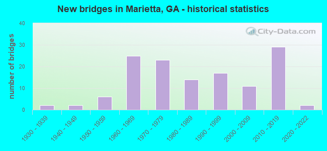
- New bridges - historical statistics
- 21930-1939
- 21940-1949
- 61950-1959
- 251960-1969
- 231970-1979
- 141980-1989
- 171990-1999
- 112000-2009
- 292010-2019
- 22020-2022

- Reconstructed bridges - Historical Statistics
- 41970-1979
- 101980-1989
- 101990-1999
- 12000-2009
- 22010-2019


- Bridge Condition - Deck
- 4.3%Very good
- 85.1%Good
- 9.6%Satisfactory
- 1.1%Fair

- Bridge Condition - Superstructure
- 26.6%Very good
- 72.3%Good
- 1.1%Satisfactory

- Bridge Condition - Substructure
- 11.7%Very good
- 84.0%Good
- 4.3%Satisfactory

- Bridge Condition - Channel
- 2.5%Excellent
- 24.1%Very good
- 58.2%Good
- 10.1%Satisfactory
- 3.8%Fair
- 1.3%Poor

- Bridge Condition - Culverts
- 5.4%Very good
- 83.8%Good
- 5.4%Satisfactory
- 5.4%Fair
Find on map >> Show street view
Structure Number: 675349, Location: NEAR KENNESAW (Lat: 33.999967, Lng: -84.561997), Route carried "on" structure: Interstate 575, Year Built: 2016, Status: Open, Structure Length: 20.91m (68.60ft), Average Daily Traffic: 1,960 (year 2018), Average Future Daily Traffic: 7,590 (year 2035), Design Load: HS 20+Mod, Features Intersected: I-75
Minimum Vertical Clearance: 30+ m (98+ ft), Kilometerpoint: 0.000, Lanes on structure: 2, Lanes under structure: 8, Base Highway Network: Yes, Toll: On toll road, Owner: State Highway Agency, Approaching Roadway Width: 8.5m (27.9ft), Material/Design: Steel, Design/Construction: Stringer/Multi-beam, Number Of Spans In Main Unit: 4, Length of Maximum Span: 67.4m (221.1ft), Curb-To-Curb Width: 8.5m (27.9ft), Out-to-Out Width: 9.5m (31.2ft)
Condition: Deck: Good, Superstructure: Very good, Substructure: Good, Operating Rating: 55.3 metric tons, Method Used To Determine Operating Rating: Load Factor (LF), Inventory Rating: 32.6 metric tons, Method Used To Determine Inventory Rating: Load Factor (LF), Structural Evaluation: Better than present minimum criteria, Underclear: Equal to present minimum criteria, Approach Roadway Alignment: Equal to present desirable criteria, Length Of Structure Improvement: 25.09m (82.32ft), Designated Inspection Frequency: Every 24 months, Inspection Date: Febuary 2022, Bridge Improvement Cost: $60,917,000, Roadway Improvement Cost: $6,092,000, Total Project Cost: $91,375,000 ( Estimate for 2018), Deck Structure Type: Concrete Cast-file-Place
Find on map >> Show street view
Structure Number: 67536, Location: 7 MI NE OF MARIETTA (Lat: 34.002317, Lng: -84.446069), Route carried "on" structure: County highway 602, Year Built: 2018, Status: Open, Structure Length: 2.74m (8.99ft), Average Daily Traffic: 4,100 (year 2019), Truck Traffic: 1%, Average Future Daily Traffic: 5,100 (year 2039), Design Load: HS 20+Mod, Features Intersected: SEWELL CREEK, Facility Carried by Structure: CASTEEL ROAD
Minimum Vertical Clearance: 30+ m (98+ ft), Kilometerpoint: 1.609, Lanes on structure: 2, Base Highway Network: Yes, Owner: County Highway Agency, Approaching Roadway Width: 6.1m (20.0ft), Material/Design: Prestressed concrete, Design/Construction: Stringer/Multi-beam, Number Of Spans In Main Unit: 3, Length of Maximum Span: 12.2m (40.0ft), Curb or Sidewalk Widths: Left: 0.0m, Right: 0.2m (0.7ft), Curb-To-Curb Width: 7.6m (24.9ft), Out-to-Out Width: 11.6m (38.1ft)
Condition: Deck: Very good, Superstructure: Very good, Substructure: Very good, Channel: Excellent, Inventory Rating: 72.5 metric tons, Method Used To Determine Inventory Rating: Load Factor (LF), Structural Evaluation: Equal to present desirable criteria, Deck Geometry: High priority of replacement, Waterway Adequacy: Superior to present desirable criteria, Approach Roadway Alignment: Equal to present minimum criteria, Length Of Structure Improvement: 3.29m (10.79ft), Designated Inspection Frequency: Every 24 months, Inspection Date: April 2021, Bridge Improvement Cost: $7,992,000, Roadway Improvement Cost: $799,000, Total Project Cost: $11,988,000 ( Estimate for 2019), Deck Structure Type: Concrete Cast-file-Place
Find on map >> Show street view
Structure Number: 675361, Location: 9 MI E OF MARIETTA (Lat: 33.986761, Lng: -84.402156), Route carried "on" structure: County highway 1513, Year Built: 2017, Status: Open, Structure Length: 1.16m (3.81ft), Average Daily Traffic: 1,930 (year 2019), Truck Traffic: 1%, Average Future Daily Traffic: 2,895 (year 2039), Design Load: HS 20+Mod, Features Intersected: WILLEO CREEK TRIB, Facility Carried by Structure: LITTLE WILLEO ROAD
Minimum Vertical Clearance: 30+ m (98+ ft), Kilometerpoint: 1.609, Lanes on structure: 2, Owner: County Highway Agency, Approaching Roadway Width: 6.1m (20.0ft), Material/Design: Prestressed concrete, Design/Construction: Box Beam or Girders - Multiple, Number Of Spans In Main Unit: 1, Length of Maximum Span: 11.6m (38.1ft), Curb or Sidewalk Widths: Left: 0.0m, Right: 2.1m (6.9ft), Curb-To-Curb Width: 7.9m (25.9ft), Out-to-Out Width: 11.2m (36.7ft)
Condition: Deck: Good, Superstructure: Good, Substructure: Very good, Channel: Very good, Inventory Rating: 72.5 metric tons, Method Used To Determine Inventory Rating: Load Factor (LF), Structural Evaluation: Better than present minimum criteria, Deck Geometry: Meets minimum limits, Waterway Adequacy: Equal to present desirable criteria, Approach Roadway Alignment: Equal to present desirable criteria, Length Of Structure Improvement: 1.40m (4.59ft), Designated Inspection Frequency: Every 24 months, Inspection Date: April 2021, Bridge Improvement Cost: $3,404,000, Roadway Improvement Cost: $340,000, Total Project Cost: $5,106,000 ( Estimate for 2019), Deck Structure Type: Concrete Precast Panels
Find on map >> Show street view
Structure Number: 675366, Location: 2.4 MI NE OF MARIETTA (Lat: 33.965428, Lng: -84.514778), Route carried "on" structure: County highway 1015, Year Built: 1992, Status: Open, Structure Length: 1.40m (4.59ft), Average Daily Traffic: 1,930 (year 2012), Truck Traffic: 1%, Average Future Daily Traffic: 2,895 (year 2032), Design Load: HS 20+Mod, Features Intersected: SOPE CREEK, Facility Carried by Structure: WALLACE ROAD
Minimum Vertical Clearance: 30+ m (98+ ft), Kilometerpoint: 0.000, Lanes on structure: 3, Base Highway Network: Yes, Owner: County Highway Agency, Approaching Roadway Width: 8.2m (26.9ft), Skew: 4 degrees, Material/Design: Concrete, Design/Construction: Culvert, Number Of Spans In Main Unit: 4, Length of Maximum Span: 3.0m (9.8ft), Curb or Sidewalk Widths: Left: 1.5m (4.9ft), Right: 0.0m
Condition: Channel: Very good, Culverts: Good, Structural Evaluation: Better than present minimum criteria, Waterway Adequacy: Superior to present desirable criteria, Approach Roadway Alignment: Equal to present desirable criteria, Length Of Structure Improvement: 1.68m (5.51ft), Designated Inspection Frequency: Every 24 months, Inspection Date: October 2021, Bridge Improvement Cost: $4,070,000, Roadway Improvement Cost: $407,000, Total Project Cost: $6,105,000 ( Estimate for 2019)
Find on map >> Show street view
Structure Number: 675368, Location: IN ELIZABETH (Lat: 33.979369, Lng: -84.560869), Route carried "on" structure: City street 9028, Year Built: 2021, Status: Open, Structure Length: 3.29m (10.79ft), Average Daily Traffic: 12,340 (year 2012), Truck Traffic: 1%, Average Future Daily Traffic: 1,850 (year 2032), Design Load: HL 93, Features Intersected: CSX RAILROAD (340397A), Facility Carried by Structure: OLD HWY 41
Minimum Vertical Clearance: 30+ m (98+ ft), Kilometerpoint: 0.000, Lanes on structure: 2, Base Highway Network: Yes, Owner: County Highway Agency, Approaching Roadway Width: 10.7m (35.1ft), Skew: 3 degrees, Material/Design: Concrete, Design/Construction: Tee Beam, Number Of Spans In Main Unit: 1, Length of Maximum Span: 32.9m (107.9ft), Curb or Sidewalk Widths: Left: 1.8m (5.9ft), Right: 1.8m (5.9ft), Curb-To-Curb Width: 11.9m (39.0ft), Out-to-Out Width: 16.0m (52.5ft)
Condition: Deck: Very good, Superstructure: Very good, Substructure: Very good, Operating Rating: 73.4 metric tons, Method Used To Determine Operating Rating: Load Factor (LF), Inventory Rating: 38.1 metric tons, Method Used To Determine Inventory Rating: Load Factor (LF), Structural Evaluation: Equal to present desirable criteria, Deck Geometry: Somewhat better than minimum adequacy, Underclear: High priority of corrective action, Approach Roadway Alignment: Equal to present desirable criteria, Length Of Structure Improvement: 3.95m (12.96ft), Designated Inspection Frequency: Every 24 months, Inspection Date: April 2021, Bridge Improvement Cost: $9,590,000, Roadway Improvement Cost: $959,000, Total Project Cost: $14,386,000 ( Estimate for 2021), Deck Structure Type: Concrete Cast-file-Place
Find on map >> Show street view
Structure Number: 67537, Location: 3.8 MI NE OF SMYRNA (Lat: 33.930050, Lng: -84.486058), Route carried "on" structure: County highway 1145, Year Built: 2021, Status: Open, Structure Length: 0.79m (2.59ft), Average Daily Traffic: 1,930 (year 2012), Truck Traffic: 1%, Average Future Daily Traffic: 2,895 (year 2032), Features Intersected: POWERS CREEK, Facility Carried by Structure: POWERS FERRY DRIVE
Minimum Vertical Clearance: 30+ m (98+ ft), Kilometerpoint: 0.000, Lanes on structure: 2, Base Highway Network: Yes, Owner: County Highway Agency, Approaching Roadway Width: 7.3m (24.0ft), Material/Design: Concrete, Design/Construction: Culvert, Number Of Spans In Main Unit: 3, Length of Maximum Span: 2.4m (7.9ft), Curb-To-Curb Width: 7.3m (24.0ft), Out-to-Out Width: 7.3m (24.0ft)
Condition: Channel: Very good, Culverts: Very good, Structural Evaluation: Equal to present desirable criteria, Deck Geometry: Meets minimum limits, Waterway Adequacy: Superior to present desirable criteria, Approach Roadway Alignment: Equal to present desirable criteria, Length Of Structure Improvement: 0.88m (2.89ft), Designated Inspection Frequency: Every 24 months, Inspection Date: September 2021, Bridge Improvement Cost: $2,131,000, Roadway Improvement Cost: $213,000, Total Project Cost: $3,197,000 ( Estimate for 2021)
Find on map >> Show street view
Structure Number: 670013, Location: IN SE MARIETTA (Lat: 33.922431, Lng: -84.505194), Route carried "under" structure: State highway 280, Structure Length: 0. m, Average Daily Traffic: 42,100 (year 1999), Truck Traffic: 1%, Features Intersected: SR 3 (US 41), Facility Carried by Structure: US 41/ SR 3
Minimum Vertical Clearance: 5.91m (19.39ft), Kilometerpoint: 20.921, Lanes on structure: 4, Length of Maximum Span: 0.0m
Find on map >> Show street view
Structure Number: 670014, Location: IN SE MARIETTA (Lat: 33.922833, Lng: -84.501147), Route carried "under" structure: State highway 280, Structure Length: 0. m, Average Daily Traffic: 42,100 (year 1999), Truck Traffic: 1%, Features Intersected: RAMP SR 3 TO SR 280 NBL
Minimum Vertical Clearance: 5.23m (17.16ft), Kilometerpoint: 20.921, Lanes on structure: 1, Length of Maximum Span: 0.0m
Find on map >> Show street view
Structure Number: 67002, Location: IN NORTH MARIETTA (Lat: 33.981742, Lng: -84.539444), Route carried "under" structure: Ramp Interstate 75, Structure Length: 0. m, Average Daily Traffic: 2,400 (year 1995), Truck Traffic: 1%, Features Intersected: M-9004 CANTON ROAD, Facility Carried by Structure: CANTON ROAD
Minimum Vertical Clearance: 5.33m (17.49ft), Kilometerpoint: 429.695, Lanes on structure: 2, Length of Maximum Span: 0.0m
Find on map >> Show street view
Structure Number: 67002, Location: IN NORTH MARIETTA (Lat: 33.981742, Lng: -84.539444), Route carried "under" structure: Ramp Interstate 75, Structure Length: 0. m, Average Daily Traffic: 2,200 (year 1991), Truck Traffic: 1%, Features Intersected: M-9004 CANTON ROAD, Facility Carried by Structure: CANTON ROAD
Minimum Vertical Clearance: 5.41m (17.75ft), Kilometerpoint: 429.695, Lanes on structure: 2, Length of Maximum Span: 0.0m
Find on map >> Show street view
Structure Number: 67002, Location: IN NORTH MARIETTA (Lat: 33.981742, Lng: -84.539444), Route carried "under" structure: Ramp Interstate 75, Structure Length: 0. m, Average Daily Traffic: 2,400 (year 1995), Truck Traffic: 1%, Features Intersected: M-9004 CANTON ROAD, Facility Carried by Structure: CANTON ROAD
Minimum Vertical Clearance: 6.37m (20.90ft), Kilometerpoint: 429.695, Lanes on structure: 2, Length of Maximum Span: 0.0m
Find on map >> Show street view
Structure Number: 67002, Location: IN NORTH MARIETTA (Lat: 33.981742, Lng: -84.539444), Route carried "under" structure: Interstate 75, Structure Length: 0. m, Average Daily Traffic: 260,600 (year 1998), Truck Traffic: 1%, Features Intersected: M-9004 CANTON ROAD, Facility Carried by Structure: CANTON ROAD
Minimum Vertical Clearance: 6.50m (21.33ft), Kilometerpoint: 429.695, Lanes on structure: 2, Length of Maximum Span: 0.0m
Find on map >> Show street view
Structure Number: 670022, Location: 2.3 MI N OF MARIETTA (Lat: 33.984250, Lng: -84.542100), Route carried "under" structure: Interstate 75, Structure Length: 0. m, Average Daily Traffic: 238,500 (year 1999), Truck Traffic: 1%, Features Intersected: SR 5 NBL, Facility Carried by Structure: SR 5 (NBL)
Minimum Vertical Clearance: 6.04m (19.82ft), Kilometerpoint: 429.695, Lanes on structure: 3, Length of Maximum Span: 0.0m
Find on map >> Show street view
Structure Number: 670022, Location: 2.3 MI N OF MARIETTA (Lat: 33.984250, Lng: -84.542100), Route carried "under" structure: Ramp Interstate 75, Structure Length: 0. m, Average Daily Traffic: 3,600 (year 1994), Truck Traffic: 1%, Features Intersected: SR 5 NBL, Facility Carried by Structure: SR 5 (NBL)
Minimum Vertical Clearance: 6.17m (20.24ft), Kilometerpoint: 429.695, Lanes on structure: 3, Length of Maximum Span: 0.0m
Find on map >> Show street view
Structure Number: 670023, Location: 2.3 MILES NORTH OF MARIET (Lat: 33.984547, Lng: -84.542233), Route carried "under" structure: Ramp Interstate 75, Structure Length: 0. m, Average Daily Traffic: 2,350 (year 1994), Truck Traffic: 1%, Features Intersected: SR 5 SBL, Facility Carried by Structure: SR 5 (SBL)
Minimum Vertical Clearance: 5.38m (17.65ft), Kilometerpoint: 429.695, Lanes on structure: 3, Length of Maximum Span: 0.0m
Find on map >> Show street view
Structure Number: 670023, Location: 2.3 MILES NORTH OF MARIET (Lat: 33.984547, Lng: -84.542233), Route carried "under" structure: Interstate 75, Structure Length: 0. m, Average Daily Traffic: 238,500 (year 1999), Truck Traffic: 1%, Features Intersected: SR 5 SBL, Facility Carried by Structure: SR 5 (SBL)
Minimum Vertical Clearance: 5.41m (17.75ft), Kilometerpoint: 429.695, Lanes on structure: 3, Length of Maximum Span: 0.0m
Find on map >> Show street view
Structure Number: 670024, Location: @ E MARIETTA CITY LIMITS (Lat: 33.987558, Lng: -84.538339), Route carried "under" structure: City street 994, Structure Length: 0. m, Average Daily Traffic: 1,820 (year 1999), Truck Traffic: 1%, Features Intersected: RAMP I-75 N TO SR 5 SPUR, Facility Carried by Structure: RM I-75 TO SR5 SP,
Minimum Vertical Clearance: 5.23m (17.16ft), Kilometerpoint: 0.000, Lanes on structure: 1, Length of Maximum Span: 0.0m
Find on map >> Show street view
Structure Number: 670025, Location: @ E MARIETTA CITY LIMITS (Lat: 33.987628, Lng: -84.538533), Route carried "under" structure: City street 994, Structure Length: 0. m, Average Daily Traffic: 1,710 (year 1999), Truck Traffic: 1%, Features Intersected: SR 5 SPUR NBL, Facility Carried by Structure: SR 5 SPUR (NBL)
Minimum Vertical Clearance: 5.81m (19.06ft), Kilometerpoint: 0.000, Lanes on structure: 2, Length of Maximum Span: 0.0m
Find on map >> Show street view
Structure Number: 670026, Location: @ E MARIETTA CITY LIMITS (Lat: 33.987758, Lng: -84.538808), Route carried "under" structure: City street 994, Structure Length: 0. m, Average Daily Traffic: 1,710 (year 1999), Truck Traffic: 1%, Features Intersected: SR 5 SPUR SBL, Facility Carried by Structure: SR 5 SPUR (SBL)
Minimum Vertical Clearance: 5.58m (18.31ft), Kilometerpoint: 0.000, Lanes on structure: 2, Length of Maximum Span: 0.0m
Find on map >> Show street view
Structure Number: 670027, Location: @ E MARIETTA CITY LIMITS (Lat: 33.987828, Lng: -84.539039), Route carried "under" structure: City street 994, Structure Length: 0. m, Average Daily Traffic: 1,820 (year 1999), Truck Traffic: 1%, Features Intersected: RAMP SR 5 SP S TO I-75, Facility Carried by Structure: RAMP SR 5 SP TO I-
Minimum Vertical Clearance: 5.48m (17.98ft), Kilometerpoint: 0.000, Lanes on structure: 1, Length of Maximum Span: 0.0m
Find on map >> Show street view
Structure Number: 670045, Location: IN EAST MARIETTA (Lat: 33.960492, Lng: -84.497119), Route carried "under" structure: State highway 120, Structure Length: 0. m, Average Daily Traffic: 50,280 (year 1999), Truck Traffic: 1%, Features Intersected: SR 120 LOOP (CBL)
Minimum Vertical Clearance: 5.43m (17.81ft), Kilometerpoint: 22.531, Lanes on structure: 2, Length of Maximum Span: 0.0m
Find on map >> Show street view
Structure Number: 670046, Location: IN EAST MARIETTA (Lat: 33.960561, Lng: -84.497006), Route carried "under" structure: State highway 120, Structure Length: 0. m, Average Daily Traffic: 62,900 (year 1999), Truck Traffic: 1%, Features Intersected: SR 120 LOOP (CCBL)
Minimum Vertical Clearance: 6.37m (20.90ft), Kilometerpoint: 22.531, Lanes on structure: 2, Length of Maximum Span: 0.0m
Find on map >> Show street view
Structure Number: 670047, Location: IN SOUTH EAST MARIETTA (Lat: 33.941047, Lng: -84.504503), Route carried "under" structure: Interstate 75, Structure Length: 0. m, Average Daily Traffic: 8,750 (year 2012), Truck Traffic: 1%, Features Intersected: SR 120 LOOP, Facility Carried by Structure: SR 120 LOOP
Minimum Vertical Clearance: 30+ m (98+ ft), Kilometerpoint: 423.258, Lanes on structure: 9, Toll: On toll road, Length of Maximum Span: 0.0m
Find on map >> Show street view
Structure Number: 670047, Location: IN SOUTH EAST MARIETTA (Lat: 33.941047, Lng: -84.504503), Route carried "under" structure: Ramp Interstate 75, Structure Length: 0. m, Average Daily Traffic: 8,750 (year 2012), Truck Traffic: 1%, Features Intersected: SR 120 LOOP, Facility Carried by Structure: SR 120 LOOP
Minimum Vertical Clearance: 5.33m (17.49ft), Kilometerpoint: 423.258, Lanes on structure: 9, Length of Maximum Span: 0.0m
Find on map >> Show street view
Structure Number: 670047, Location: IN SOUTH EAST MARIETTA (Lat: 33.941047, Lng: -84.504503), Route carried "under" structure: Interstate 75, Structure Length: 0. m, Average Daily Traffic: 259,900 (year 1999), Truck Traffic: 1%, Features Intersected: SR 120 LOOP, Facility Carried by Structure: SR 120 LOOP
Minimum Vertical Clearance: 6.17m (20.24ft), Kilometerpoint: 423.258, Lanes on structure: 9, Length of Maximum Span: 0.0m
Find on map >> Show street view
Structure Number: 670057, Location: 4.2 MI SE OF MARIETTA (Lat: 33.922800, Lng: -84.485492), Route carried "under" structure: Ramp Interstate 75, Structure Length: 0. m, Average Daily Traffic: 7,550 (year 1991), Truck Traffic: 1%, Features Intersected: SR 280, Facility Carried by Structure: SR 280
Minimum Vertical Clearance: 5.23m (17.16ft), Kilometerpoint: 421.648, Lanes on structure: 8, Length of Maximum Span: 0.0m
Find on map >> Show street view
Structure Number: 670057, Location: 4.2 MI SE OF MARIETTA (Lat: 33.922800, Lng: -84.485492), Route carried "under" structure: Interstate 75, Structure Length: 0. m, Average Daily Traffic: 296,300 (year 1999), Truck Traffic: 1%, Features Intersected: SR 280, Facility Carried by Structure: SR 280
Minimum Vertical Clearance: 6.75m (22.15ft), Kilometerpoint: 421.648, Lanes on structure: 8, Length of Maximum Span: 0.0m
Find on map >> Show street view
Structure Number: 670068, Location: 4.9 MI SE OF MARIETTA (Lat: 33.911939, Lng: -84.478858), Route carried "under" structure: City street 9495, Structure Length: 0. m, Average Daily Traffic: 15,820 (year 1998), Truck Traffic: 1%, Features Intersected: I-75 NBL, Facility Carried by Structure: I-75 (NBL)
Minimum Vertical Clearance: 5.08m (16.67ft), Kilometerpoint: 1.609, Lanes on structure: 8, Length of Maximum Span: 0.0m
Find on map >> Show street view
Structure Number: 670069, Location: 4.9 MI SE OF MARIETTA (Lat: 33.911828, Lng: -84.479408), Route carried "under" structure: City street 9495, Structure Length: 0. m, Average Daily Traffic: 15,820 (year 1998), Truck Traffic: 1%, Features Intersected: I-75 SBL, I-75 ML, Facility Carried by Structure: I-75SBL,I-75ML
Minimum Vertical Clearance: 5.56m (18.24ft), Kilometerpoint: 1.609, Lanes on structure: 7, Length of Maximum Span: 0.0m
Find on map >> Show street view
Structure Number: 670072, Location: IN EAST MARIETTA (Lat: 33.945508, Lng: -84.511358), Route carried "under" structure: City street 1043, Structure Length: 0. m, Average Daily Traffic: 2,850 (year 1998), Truck Traffic: 1%, Features Intersected: I-75, Facility Carried by Structure: I-75
Minimum Vertical Clearance: 4.72m (15.49ft), Kilometerpoint: 0.000, Lanes on structure: 12, Length of Maximum Span: 0.0m
Find on map >> Show street view
Structure Number: 670073, Location: IN EAST MARIETTA (Lat: 33.950861, Lng: -84.516311), Route carried "under" structure: State highway 3, Structure Length: 0. m, Average Daily Traffic: 31,900 (year 1998), Truck Traffic: 1%, Features Intersected: I-75, Facility Carried by Structure: I-75
Minimum Vertical Clearance: 5.02m (16.47ft), Kilometerpoint: 19.312, Lanes on structure: 10, Length of Maximum Span: 0.0m
Find on map >> Show street view
Structure Number: 670074, Location: IN EAST MARIETTA (Lat: 33.961628, Lng: -84.519792), Route carried "under" structure: State highway 120, Structure Length: 0. m, Average Daily Traffic: 23,700 (year 1998), Truck Traffic: 1%, Features Intersected: I-75, Facility Carried by Structure: I-75
Minimum Vertical Clearance: 6.45m (21.16ft), Kilometerpoint: 0.000, Lanes on structure: 10, Length of Maximum Span: 0.0m
Find on map >> Show street view
Structure Number: 670076, Location: 2.5 MI N OF MARIETTA (Lat: 33.988925, Lng: -84.547075), Route carried "under" structure: County highway 992, Structure Length: 0. m, Average Daily Traffic: 2,000 (year 1998), Truck Traffic: 1%, Features Intersected: I-75, Facility Carried by Structure: I-75
Minimum Vertical Clearance: 4.95m (16.24ft), Kilometerpoint: 0.000, Lanes on structure: 12, Length of Maximum Span: 0.0m
Find on map >> Show street view
Structure Number: 670078, Location: 2.7 MI N OF MARIETTA (Lat: 33.991078, Lng: -84.551139), Route carried "under" structure: City street 9020, Structure Length: 0. m, Average Daily Traffic: 11,800 (year 1998), Truck Traffic: 1%, Features Intersected: I-75, Facility Carried by Structure: I-75
Minimum Vertical Clearance: 5.10m (16.73ft), Kilometerpoint: 4.828, Lanes on structure: 12, Length of Maximum Span: 0.0m
Find on map >> Show street view
Structure Number: 670081, Location: 2.9 MILES SE OF KENNESAW (Lat: 34.009978, Lng: -84.567408), Route carried "under" structure: State highway 5, Structure Length: 0. m, Average Daily Traffic: 34,300 (year 2005), Truck Traffic: 1%, Features Intersected: I-75 NBL
Minimum Vertical Clearance: 5.46m (17.91ft), Kilometerpoint: 1.609, Lanes on structure: 3, Length of Maximum Span: 0.0m
Find on map >> Show street view
Structure Number: 670082, Location: 2.9 MI SE OF KENNESAW (Lat: 34.009639, Lng: -84.568008), Route carried "under" structure: State highway 5, Structure Length: 0. m, Average Daily Traffic: 45,700 (year 2005), Truck Traffic: 1%, Features Intersected: I-75 SBL
Minimum Vertical Clearance: 6.47m (21.23ft), Kilometerpoint: 1.609, Lanes on structure: 3, Length of Maximum Span: 0.0m
Find on map >> Show street view
Structure Number: 67011, Location: 3.6 MI SE OF KENNESAW (Lat: 34.000228, Lng: -84.562158), Route carried "under" structure: Interstate 75, Structure Length: 0. m, Average Daily Traffic: 169,400 (year 1998), Truck Traffic: 1%, Features Intersected: SR 417 SBL (I-575)
Minimum Vertical Clearance: 5.63m (18.47ft), Kilometerpoint: 432.914, Lanes on structure: 2, Length of Maximum Span: 0.0m
Find on map >> Show street view
Structure Number: 67011, Location: 3.6 MI SE OF KENNESAW (Lat: 34.000228, Lng: -84.562158), Route carried "under" structure: Interstate 75, Structure Length: 0. m, Average Daily Traffic: 169,400 (year 1998), Truck Traffic: 1%, Features Intersected: SR 417 SBL (I-575)
Minimum Vertical Clearance: 5.41m (17.75ft), Kilometerpoint: 432.914, Lanes on structure: 2, Toll: On toll road, Length of Maximum Span: 0.0m
Find on map >> Show street view
Structure Number: 670111, Location: 3 MI E OF KENNESAW (Lat: 34.014078, Lng: -84.558619), Route carried "under" structure: State highway 5, Structure Length: 0. m, Average Daily Traffic: 34,300 (year 1998), Truck Traffic: 1%, Features Intersected: SR 417 NBL (I-575)
Minimum Vertical Clearance: 6.70m (21.98ft), Kilometerpoint: 3.219, Lanes on structure: 2, Length of Maximum Span: 0.0m
Find on map >> Show street view
Structure Number: 670112, Location: 3 MI E OF KENNESAW (Lat: 34.014089, Lng: -84.558928), Route carried "under" structure: State highway 5, Structure Length: 0. m, Average Daily Traffic: 34,300 (year 1998), Truck Traffic: 1%, Features Intersected: SR 417 SBL (I-575)
Minimum Vertical Clearance: 5.51m (18.08ft), Kilometerpoint: 3.219, Lanes on structure: 2, Length of Maximum Span: 0.0m
Find on map >> Show street view
Structure Number: 670143, Location: 3.5 MI NE OF SMYRNA (Lat: 33.901786, Lng: -84.473467), Route carried "under" structure: Interstate 75, Structure Length: 0. m, Average Daily Traffic: 15,150 (year 1995), Truck Traffic: 1%, Features Intersected: M-9001 WINDY HILL ROAD, Facility Carried by Structure: WINDY HILL ROAD
Minimum Vertical Clearance: 7.97m (26.15ft), Kilometerpoint: 418.430, Lanes on structure: 6, Toll: On toll road, Length of Maximum Span: 0.0m
Find on map >> Show street view
Structure Number: 670143, Location: 3.5 MI NE OF SMYRNA (Lat: 33.901786, Lng: -84.473467), Route carried "under" structure: Interstate 75, Structure Length: 0. m, Average Daily Traffic: 327,800 (year 2010), Truck Traffic: 1%, Features Intersected: M-9001 WINDY HILL ROAD, Facility Carried by Structure: WINDY HILL ROAD
Minimum Vertical Clearance: 5.66m (18.57ft), Kilometerpoint: 418.430, Lanes on structure: 6, Length of Maximum Span: 0.0m
Find on map >> Show street view
Structure Number: 670162, Location: IN NORTH MARIETTA (Lat: 33.972792, Lng: -84.530625), Route carried "under" structure: Interstate 75, Structure Length: 0. m, Average Daily Traffic: 104,200 (year 1998), Truck Traffic: 1%, Features Intersected: M-9032 ALLGOOD ROAD, Facility Carried by Structure: ALLGOOD ROAD
Minimum Vertical Clearance: 30+ m (98+ ft), Kilometerpoint: 428.086, Lanes on structure: 4, Toll: On toll road, Length of Maximum Span: 0.0m
Find on map >> Show street view
Structure Number: 670162, Location: IN NORTH MARIETTA (Lat: 33.972792, Lng: -84.530625), Route carried "under" structure: Interstate 75, Structure Length: 0. m, Average Daily Traffic: 260,600 (year 1998), Truck Traffic: 1%, Features Intersected: M-9032 ALLGOOD ROAD, Facility Carried by Structure: ALLGOOD ROAD
Minimum Vertical Clearance: 5.99m (19.65ft), Kilometerpoint: 428.086, Lanes on structure: 4, Length of Maximum Span: 0.0m
Find on map >> Show street view
Structure Number: 670173, Location: IN NORTH MARIETTA (Lat: 33.981392, Lng: -84.539000), Route carried "under" structure: Interstate 75, Structure Length: 0. m, Average Daily Traffic: 225,340 (year 2012), Truck Traffic: 1%, Features Intersected: I-75, Facility Carried by Structure: CSX RR (340935E)
Minimum Vertical Clearance: 5.53m (18.14ft), Kilometerpoint: 429.695, Length of Maximum Span: 0.0m
Find on map >> Show street view
Structure Number: 670177, Location: SOUTH SIDE IN MARIETTA (Lat: 33.947539, Lng: -84.548950), Route carried "under" structure: State highway 5, Structure Length: 0. m, Average Daily Traffic: 24,330 (year 2012), Truck Traffic: 1%, Features Intersected: SR 5, Facility Carried by Structure: CSX RAILROAD
Minimum Vertical Clearance: 5.15m (16.90ft), Kilometerpoint: 19.312, Length of Maximum Span: 0.0m
Find on map >> Show street view
Structure Number: 670183, Location: 1.5 MI N OF MARIETTA (Lat: 33.974308, Lng: -84.550408), Route carried "under" structure: City street 9019, Structure Length: 0. m, Average Daily Traffic: 29,051 (year 1991), Truck Traffic: 1%, Features Intersected: SR 5, Facility Carried by Structure: SR 5
Minimum Vertical Clearance: 6.35m (20.83ft), Kilometerpoint: 0.000, Lanes on structure: 4, Length of Maximum Span: 0.0m
Find on map >> Show street view
Structure Number: 670184, Location: 1.6 MI N OF MARIETTA (Lat: 33.977297, Lng: -84.549456), Route carried "under" structure: US 41, Structure Length: 0. m, Average Daily Traffic: 43,400 (year 1999), Truck Traffic: 1%, Features Intersected: SR 5, Facility Carried by Structure: SR 5
Minimum Vertical Clearance: 6.88m (22.57ft), Kilometerpoint: 16.093, Lanes on structure: 4, Length of Maximum Span: 0.0m
Find on map >> Show street view
Structure Number: 670185, Location: 2 MI N OF MARIETTA (Lat: 33.982608, Lng: -84.540389), Route carried "under" structure: Ramp Interstate 75, Structure Length: 0. m, Average Daily Traffic: 3,500 (year 1994), Truck Traffic: 1%, Features Intersected: SR 5 NBL, Facility Carried by Structure: SR 5 (NBL)
Minimum Vertical Clearance: 5.38m (17.65ft), Kilometerpoint: 429.695, Lanes on structure: 1, Length of Maximum Span: 0.0m
Find on map >> Show street view
Structure Number: 670185, Location: 2 MI N OF MARIETTA (Lat: 33.982608, Lng: -84.540389), Route carried "under" structure: Interstate 75, Structure Length: 0. m, Average Daily Traffic: 260,600 (year 1999), Truck Traffic: 1%, Features Intersected: SR 5 NBL, Facility Carried by Structure: SR 5 (NBL)
Minimum Vertical Clearance: 6.24m (20.47ft), Kilometerpoint: 429.695, Lanes on structure: 1, Length of Maximum Span: 0.0m
Find on map >> Show street view
Structure Number: 670186, Location: 2 MI N OF MARIETTA (Lat: 33.986100, Lng: -84.540069), Route carried "under" structure: Spur State highway 5, Structure Length: 0. m, Average Daily Traffic: 42,050 (year 1999), Truck Traffic: 1%, Features Intersected: SR 5 NBL
Minimum Vertical Clearance: 5.71m (18.73ft), Kilometerpoint: 0.000, Lanes on structure: 1, Length of Maximum Span: 0.0m
Find on map >> Show street view
Structure Number: 670202, Location: 1.2 MI S OF MARIETTA (Lat: 33.935528, Lng: -84.541269), Route carried "under" structure: State highway 280, Structure Length: 0. m, Average Daily Traffic: 36,150 (year 2012), Truck Traffic: 1%, Features Intersected: SR 280 SOUTH COBB DRIVE, Facility Carried by Structure: CSX RR (340383S)
Minimum Vertical Clearance: 5.48m (17.98ft), Kilometerpoint: 16.093, Length of Maximum Span: 0.0m
Find on map >> Show street view
Structure Number: 670205, Location: IN MARIETTA CITY LIMITS (Lat: 33.957650, Lng: -84.551311), Route carried "under" structure: State highway 5, Structure Length: 0. m, Average Daily Traffic: 36,630 (year 2012), Truck Traffic: 1%, Features Intersected: SR 5, Facility Carried by Structure: NOR SOUTHERN RAILR
Minimum Vertical Clearance: 5.76m (18.90ft), Kilometerpoint: 20.921, Length of Maximum Span: 0.0m
Find on map >> Show street view
Structure Number: 670206, Location: IN MARIETTA CITY LIMITS (Lat: 33.957406, Lng: -84.551603), Route carried "under" structure: State highway 5, Structure Length: 0. m, Average Daily Traffic: 38,400 (year 1998), Truck Traffic: 1%, Features Intersected: M-9024 KENNESAW AVE., Facility Carried by Structure: KENNESAW AVENUE
Minimum Vertical Clearance: 6.45m (21.16ft), Kilometerpoint: 20.921, Lanes on structure: 2, Length of Maximum Span: 0.0m
Find on map >> Show street view
Structure Number: 670207, Location: RAMP I-75N TO SR 5C EBL (Lat: 33.981556, Lng: -84.538622), Route carried "under" structure: Ramp Interstate 75, Structure Length: 0. m, Average Daily Traffic: 9,980 (year 2012), Truck Traffic: 1%, Features Intersected: I-75 RAMP, Facility Carried by Structure: CSX RR (340935E)
Minimum Vertical Clearance: 5.61m (18.41ft), Kilometerpoint: 429.695, Length of Maximum Span: 0.0m
Find on map >> Show street view
Structure Number: 670208, Location: RAMP SR5 C TO I-75 SBL (Lat: 33.981186, Lng: -84.539447), Route carried "under" structure: Ramp Interstate 75, Structure Length: 0. m, Average Daily Traffic: 10,390 (year 2010), Truck Traffic: 1%, Features Intersected: I-75 RAMP, Facility Carried by Structure: CSX RR (340935E)
Minimum Vertical Clearance: 5.74m (18.83ft), Kilometerpoint: 429.695, Length of Maximum Span: 0.0m
Find on map >> Show street view
Structure Number: 670211, Location: IN EAST MARIETTA (Lat: 33.955300, Lng: -84.516478), Route carried "under" structure: Interstate 75, Structure Length: 0. m, Average Daily Traffic: 258,500 (year 1998), Truck Traffic: 1%, Features Intersected: CR 1253 GRESHAM ROAD, Facility Carried by Structure: GRESHAM ROAD
Minimum Vertical Clearance: 5.91m (19.39ft), Kilometerpoint: 426.476, Lanes on structure: 4, Length of Maximum Span: 0.0m
Find on map >> Show street view
Structure Number: 670211, Location: IN EAST MARIETTA (Lat: 33.955300, Lng: -84.516478), Route carried "under" structure: Interstate 575, Structure Length: 0. m, Average Daily Traffic: 104,200 (year 1998), Truck Traffic: 1%, Features Intersected: CR 1253 GRESHAM ROAD, Facility Carried by Structure: GRESHAM ROAD
Minimum Vertical Clearance: 30+ m (98+ ft), Kilometerpoint: 0.000, Lanes on structure: 4, Toll: On toll road, Length of Maximum Span: 0.0m
Find on map >> Show street view
Structure Number: 675154, Location: IN EAST MARIETTA (Lat: 33.931983, Lng: -84.516203), Route carried "under" structure: City street 1638, Structure Length: 0. m, Average Daily Traffic: 1,930 (year 2012), Truck Traffic: 1%, Features Intersected: CR 1638 BARCLAY ROAD, Facility Carried by Structure: PEDESTRIAN BRIDGE
Minimum Vertical Clearance: 6.24m (20.47ft), Kilometerpoint: 0.000, Length of Maximum Span: 0.0m
Find on map >> Show street view
Structure Number: 675165, Location: 2.75 MI S OF KENNE (Lat: 33.983158, Lng: -84.606758), Route carried "under" structure: City street 9027, Structure Length: 0. m, Average Daily Traffic: 45,110 (year 2012), Truck Traffic: 1%, Features Intersected: BARRETT PARKWAY, Facility Carried by Structure: CSX RAILROAD
Minimum Vertical Clearance: 6.80m (22.31ft), Kilometerpoint: 4.828, Length of Maximum Span: 0.0m
Find on map >> Show street view
Structure Number: 675239, Location: 4.8 MI SW OF MARIETTA (Lat: 33.923956, Lng: -84.629656), Route carried "under" structure: County highway 8228, Structure Length: 0. m, Average Daily Traffic: 2,325 (year 2006), Truck Traffic: 4%, Features Intersected: IRWIN ROAD, Facility Carried by Structure: IRWIN ROAD
Minimum Vertical Clearance: 5.74m (18.83ft), Kilometerpoint: 3.219, Lanes on structure: 2, Length of Maximum Span: 0.0m
Find on map >> Show street view
Structure Number: 675286, Location: MARIETTA CITY LIMITS (Lat: 33.970417, Lng: -84.558150), Route carried "under" structure: County highway 895, Structure Length: 0. m, Average Daily Traffic: 1,930 (year 2012), Truck Traffic: 1%, Features Intersected: TOWER ROAD (639136G), Facility Carried by Structure: CSX RAILROAD
Minimum Vertical Clearance: 5.63m (18.47ft), Kilometerpoint: 0.000, Length of Maximum Span: 0.0m
Find on map >> Show street view
Structure Number: 675297, Location: 3.6 MILES WEST OF SYMRNA (Lat: 33.896531, Lng: -84.591217), Route carried "under" structure: County highway 1720, Structure Length: 0. m, Average Daily Traffic: 2,270 (year 2012), Truck Traffic: 6%, Features Intersected: CALLAWAY ROAD, Facility Carried by Structure: CALLAWAY ROAD
Minimum Vertical Clearance: 5.86m (19.23ft), Kilometerpoint: 1.609, Lanes on structure: 5, Length of Maximum Span: 0.0m
Find on map >> Show street view
Structure Number: 675298, Location: 3.3 MILES WEST OF SYMRNA (Lat: 33.896169, Lng: -84.589553), Route carried "under" structure: County highway 9001, Structure Length: 0. m, Average Daily Traffic: 1,930 (year 2012), Truck Traffic: 1%, Features Intersected: WINDY HILL/MACLAND CONN., Facility Carried by Structure: JIM R. MILLER PARK
Minimum Vertical Clearance: 5.20m (17.06ft), Kilometerpoint: 1.609, Length of Maximum Span: 0.0m
Find on map >> Show street view
Structure Number: 675302, Location: IN EAST MARIETTA (Lat: 33.960350, Lng: -84.497256), Route carried "under" structure: State highway 120, Structure Length: 0. m, Average Daily Traffic: 62,900 (year 1999), Truck Traffic: 1%, Features Intersected: SR120 LOOP(CBL)
Minimum Vertical Clearance: 6.22m (20.41ft), Kilometerpoint: 22.531, Lanes on structure: 2, Length of Maximum Span: 0.0m
Find on map >> Show street view
Structure Number: 675305, Location: IN MARIETTA CITY LIMITS (Lat: 33.957778, Lng: -84.551228), Route carried "under" structure: US 120, Structure Length: 0. m, Average Daily Traffic: 5,000 (year 2013), Truck Traffic: 1%, Features Intersected: SR 120 LOOP, Facility Carried by Structure: PEDESTRIAN OVERPAS
Minimum Vertical Clearance: 6.95m (22.80ft), Kilometerpoint: 11.265, Length of Maximum Span: 0.0m
Find on map >> Show street view
Structure Number: 675314, Location: 1.6 MI N OF MARIETTA (Lat: 33.976269, Lng: -84.547389), Route carried "under" structure: US 41, Structure Length: 0. m, Average Daily Traffic: 37,500 (year 2008), Truck Traffic: 5%, Features Intersected: M-9004 CANTON ROAD, Facility Carried by Structure: CANTON ROAD
Minimum Vertical Clearance: 5.63m (18.47ft), Kilometerpoint: 16.093, Lanes on structure: 2, Length of Maximum Span: 0.0m
Find on map >> Show street view
Structure Number: 675319, Location: 1.6 MILES NORTH OF MARIET (Lat: 33.976358, Lng: -84.547458), Route carried "under" structure: US 41, Structure Length: 0. m, Average Daily Traffic: 35,530 (year 2012), Truck Traffic: 1%, Features Intersected: SR 3 (US 41), Facility Carried by Structure: CSX RR (351808J)
Minimum Vertical Clearance: 0.45m (1.48ft), Kilometerpoint: 16.093, Length of Maximum Span: 0.0m
Find on map >> Show street view
Structure Number: 67532, Location: IN NORTH MARIETTA (Lat: 33.981367, Lng: -84.539900), Route carried "under" structure: City street 9004, Structure Length: 0. m, Average Daily Traffic: 9,540 (year 2012), Truck Traffic: 1%, Features Intersected: I-75 MANAGED LANES, Facility Carried by Structure: I-75 MANAGED LANES
Minimum Vertical Clearance: 30+ m (98+ ft), Kilometerpoint: 1.609, Lanes on structure: 2, Length of Maximum Span: 0.0m
Find on map >> Show street view
Structure Number: 67532, Location: IN NORTH MARIETTA (Lat: 33.981367, Lng: -84.539900), Route carried "under" structure: Ramp Interstate 401, Structure Length: 0. m, Average Daily Traffic: 2,350 (year 1994), Truck Traffic: 1%, Features Intersected: I-75 MANAGED LANES, Facility Carried by Structure: I-75 MANAGED LANES
Minimum Vertical Clearance: 30+ m (98+ ft), Kilometerpoint: 429.695, Lanes on structure: 2, Length of Maximum Span: 0.0m
Find on map >> Show street view
Structure Number: 67532, Location: IN NORTH MARIETTA (Lat: 33.981367, Lng: -84.539900), Route carried "under" structure: Ramp State highway 5, Structure Length: 0. m, Average Daily Traffic: 2,350 (year 1994), Truck Traffic: 3%, Features Intersected: I-75 MANAGED LANES
Minimum Vertical Clearance: 30+ m (98+ ft), Kilometerpoint: 24.140, Lanes on structure: 2, Length of Maximum Span: 0.0m
Find on map >> Show street view
Structure Number: 67532, Location: IN NORTH MARIETTA (Lat: 33.981367, Lng: -84.539900), Route carried "under" structure: Ramp State highway 5, Structure Length: 0. m, Average Daily Traffic: 15,560 (year 2012), Truck Traffic: 3%, Features Intersected: I-75 MANAGED LANES
Minimum Vertical Clearance: 30+ m (98+ ft), Kilometerpoint: 24.140, Lanes on structure: 2, Length of Maximum Span: 0.0m
Find on map >> Show street view
Structure Number: 67532, Location: IN NORTH MARIETTA (Lat: 33.981367, Lng: -84.539900), Route carried "under" structure: Ramp Interstate 401, Structure Length: 0. m, Average Daily Traffic: 3,250 (year 2012), Truck Traffic: 3%, Features Intersected: I-75 MANAGED LANES, Facility Carried by Structure: I-75 MANAGED LANES
Minimum Vertical Clearance: 30+ m (98+ ft), Kilometerpoint: 429.695, Lanes on structure: 1, Length of Maximum Span: 0.0m
Find on map >> Show street view
Structure Number: 67532, Location: IN NORTH MARIETTA (Lat: 33.981367, Lng: -84.539900), Route carried "under" structure: State highway 9004, Structure Length: 0. m, Average Daily Traffic: 15,560 (year 2012), Truck Traffic: 3%, Features Intersected: I-75 MANAGED LANES, Facility Carried by Structure: I-75 MANAGED LANES
Minimum Vertical Clearance: 30+ m (98+ ft), Kilometerpoint: 24.140, Lanes on structure: 2, Length of Maximum Span: 0.0m
Find on map >> Show street view
Structure Number: 675321, Location: NEAR KENNESAW (Lat: 34.009450, Lng: -84.567481), Route carried "under" structure: Interstate 401, Structure Length: 0. m, Average Daily Traffic: 104,200 (year 1998), Truck Traffic: 1%, Features Intersected: I-75 MANAGED LANES, Facility Carried by Structure: I-75 MANAGED LANES
Minimum Vertical Clearance: 5.76m (18.90ft), Kilometerpoint: 432.914, Lanes on structure: 1, Length of Maximum Span: 0.0m
Find on map >> Show street view
Structure Number: 675321, Location: NEAR KENNESAW (Lat: 34.009450, Lng: -84.567481), Route carried "under" structure: Ramp State highway 5, Structure Length: 0. m, Average Daily Traffic: 9,999 (year 2016), Truck Traffic: 3%, Features Intersected: I-75 MANAGED LANES
Minimum Vertical Clearance: 7.44m (24.41ft), Kilometerpoint: 1.609, Lanes on structure: 1, Length of Maximum Span: 0.0m
Find on map >> Show street view
Structure Number: 675321, Location: NEAR KENNESAW (Lat: 34.009450, Lng: -84.567481), Route carried "under" structure: State highway 401, Structure Length: 0. m, Average Daily Traffic: 9,999 (year 2016), Truck Traffic: 1%, Features Intersected: I-75 MANAGED LANES, Facility Carried by Structure: I-75 MANAGED LANES
Minimum Vertical Clearance: 9.90m (32.48ft), Kilometerpoint: 432.914, Lanes on structure: 1, Length of Maximum Span: 0.0m
Find on map >> Show street view
Structure Number: 675322, Location: 3 MI E OF KENNESAW (Lat: 34.014097, Lng: -84.558781), Route carried "under" structure: State highway 5, Structure Length: 0. m, Average Daily Traffic: 9,999 (year 2016), Truck Traffic: 1%, Features Intersected: I-575 MANAGED LANES
Minimum Vertical Clearance: 6.19m (20.31ft), Kilometerpoint: 3.219, Lanes on structure: 2, Length of Maximum Span: 0.0m
Find on map >> Show street view
Structure Number: 67533, Location: IN EAST MARIETTA (Lat: 33.961394, Lng: -84.520925), Route carried "under" structure: State highway 120, Structure Length: 0. m, Average Daily Traffic: 23,700 (year 1998), Truck Traffic: 1%, Features Intersected: I-75 MANAGED LANES, Facility Carried by Structure: I-75 MANAGED LANES
Minimum Vertical Clearance: 6.45m (21.16ft), Kilometerpoint: 0.000, Lanes on structure: 2, Length of Maximum Span: 0.0m
Find on map >> Show street view
Structure Number: 675337, Location: 2.7 MILES NORTH EAST OF S (Lat: 33.903100, Lng: -84.474900), Route carried "under" structure: Interstate 401, Structure Length: 0. m, Average Daily Traffic: 104,200 (year 1998), Truck Traffic: 1%, Features Intersected: I-75 OFF RAMP, Facility Carried by Structure: I-75 OFF RAMP
Minimum Vertical Clearance: 5.53m (18.14ft), Kilometerpoint: 418.430, Lanes on structure: 2, Length of Maximum Span: 0.0m
Find on map >> Show street view
Structure Number: 675338, Location: IN EAST MARIETTA (Lat: 33.922281, Lng: -84.485747), Route carried "under" structure: State highway 280, Structure Length: 0. m, Average Daily Traffic: 31,680 (year 2012), Truck Traffic: 4%, Features Intersected: I-75 MANAGED LANES, Facility Carried by Structure: I-75 MANAGED LANES
Minimum Vertical Clearance: 5.46m (17.91ft), Kilometerpoint: 22.531, Lanes on structure: 8, Length of Maximum Span: 0.0m
Find on map >> Show street view
Structure Number: 675338, Location: IN EAST MARIETTA (Lat: 33.922281, Lng: -84.485747), Route carried "under" structure: Ramp Interstate 75, Structure Length: 0. m, Average Daily Traffic: 6,650 (year 2018), Truck Traffic: 4%, Features Intersected: I-75 MANAGED LANES
Minimum Vertical Clearance: 9.77m (32.05ft), Kilometerpoint: 420.039, Lanes on structure: 2, Length of Maximum Span: 0.0m
Find on map >> Show street view
Structure Number: 675338, Location: IN EAST MARIETTA (Lat: 33.922281, Lng: -84.485747), Route carried "under" structure: Ramp State highway 75, Structure Length: 0. m, Average Daily Traffic: 6,650 (year 2018), Truck Traffic: 4%, Features Intersected: I-75 MANAGED LANES
Minimum Vertical Clearance: 6.12m (20.08ft), Kilometerpoint: 420.039, Lanes on structure: 1, Length of Maximum Span: 0.0m
Find on map >> Show street view
Structure Number: 67534, Location: IN EAST MARIETTA (Lat: 33.936231, Lng: -84.497367), Route carried "under" structure: Ramp Interstate 75, Structure Length: 0. m, Average Daily Traffic: 6,650 (year 2018), Truck Traffic: 1%, Features Intersected: I-75 MANAGED LANES
Minimum Vertical Clearance: 6.57m (21.56ft), Kilometerpoint: 423.258, Lanes on structure: 2, Length of Maximum Span: 0.0m
Find on map >> Show street view
Structure Number: 675341, Location: 2.7 MI E OF MARIETTA (Lat: 33.942036, Lng: -84.506919), Route carried "under" structure: Interstate 75, Structure Length: 0. m, Average Daily Traffic: 2,060 (year 2018), Truck Traffic: 6%, Features Intersected: I-75 RAMP TO SR120
Minimum Vertical Clearance: 5.41m (17.75ft), Kilometerpoint: 423.258, Lanes on structure: 1, Length of Maximum Span: 0.0m
Find on map >> Show street view
Structure Number: 675343, Location: IN MARIETTA (Lat: 33.945481, Lng: -84.512181), Route carried "under" structure: City street 1043, Structure Length: 0. m, Average Daily Traffic: 2,850 (year 1998), Features Intersected: I-75 MANAGED LANES, Facility Carried by Structure: I-75 MANAGED LANES
Minimum Vertical Clearance: 5.46m (17.91ft), Kilometerpoint: 0.000, Lanes on structure: 2, Length of Maximum Span: 0.0m
Find on map >> Show street view
Structure Number: 675344, Location: IN EAST MARIETTA (Lat: 33.950867, Lng: -84.516781), Route carried "under" structure: State highway 3, Structure Length: 0. m, Average Daily Traffic: 31,900 (year 1998), Truck Traffic: 1%, Features Intersected: I-75 MANAGED LANES, Facility Carried by Structure: I-75 MANAGED LANES
Minimum Vertical Clearance: 5.38m (17.65ft), Kilometerpoint: 19.312, Lanes on structure: 2, Length of Maximum Span: 0.0m
Find on map >> Show street view
Structure Number: 675346, Location: NORTH MARIETTA (Lat: 33.988750, Lng: -84.547617), Route carried "under" structure: County highway 992, Structure Length: 0. m, Average Daily Traffic: 2,000 (year 1998), Features Intersected: I-75 MANAGED LANES, Facility Carried by Structure: I-75 MANAGED LANES
Minimum Vertical Clearance: 7.13m (23.39ft), Kilometerpoint: 0.000, Lanes on structure: 2, Length of Maximum Span: 0.0m
Find on map >> Show street view
Structure Number: 675347, Location: NORTH MARIETTA (Lat: 33.990631, Lng: -84.551381), Route carried "under" structure: City street 9020, Structure Length: 0. m, Average Daily Traffic: 11,800 (year 1998), Truck Traffic: 1%, Features Intersected: I-75 MANAGED LANES, Facility Carried by Structure: I-75 MANAGED LANE
Minimum Vertical Clearance: 5.33m (17.49ft), Kilometerpoint: 4.828, Lanes on structure: 2, Length of Maximum Span: 0.0m
Find on map >> Show street view
Structure Number: 675348, Location: NORTH MARIETTA (Lat: 33.995831, Lng: -84.559867), Route carried "under" structure: Interstate 575, Structure Length: 0. m, Average Daily Traffic: 2,000 (year 1998), Features Intersected: I-75
Minimum Vertical Clearance: 7.13m (23.39ft), Kilometerpoint: 432.914, Lanes on structure: 2, Length of Maximum Span: 0.0m
Find on map >> Show street view
Structure Number: 675349, Location: NEAR KENNESAW (Lat: 33.999967, Lng: -84.561997), Route carried "under" structure: Interstate 575, Structure Length: 0. m, Average Daily Traffic: 104,200 (year 1998), Truck Traffic: 1%, Features Intersected: I-575 MANAGED LANES
Minimum Vertical Clearance: 8.66m (28.41ft), Kilometerpoint: 432.914, Lanes on structure: 2, Length of Maximum Span: 0.0m
Find on map >> Show street view
Structure Number: 675349, Location: NEAR KENNESAW (Lat: 33.999967, Lng: -84.561997), Route carried "under" structure: Interstate 575, Structure Length: 0. m, Average Daily Traffic: 104,200 (year 1998), Truck Traffic: 1%, Features Intersected: I-575 MANAGED LANES
Minimum Vertical Clearance: 30+ m (98+ ft), Kilometerpoint: 432.914, Lanes on structure: 2, Length of Maximum Span: 0.0m
Find on map >> Show street view
Structure Number: 675362, Location: SOUTH SIDE IN MARIETTA (Lat: 33.947578, Lng: -84.549192), Route carried "under" structure: US 5, Structure Length: 0. m, Average Daily Traffic: 24,330 (year 2012), Truck Traffic: 1%, Features Intersected: SR5, Facility Carried by Structure: PEDESTRIAN BRIDGE
Minimum Vertical Clearance: 5.41m (17.75ft), Kilometerpoint: 20.020, Length of Maximum Span: 0.0m