Bridge Statistics for McComb, Mississippi (MS)
Condition, Traffic, Stress, Structural Evaluation, Project Costs
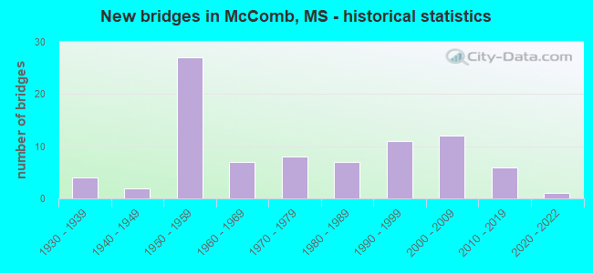
- New bridges - historical statistics
- 41930-1939
- 21940-1949
- 271950-1959
- 71960-1969
- 81970-1979
- 71980-1989
- 111990-1999
- 122000-2009
- 62010-2019
- 12020-2022

- Reconstructed bridges - Historical Statistics
- 21990-1999
- 12000-2009
- 12010-2019


- Bridge Condition - Deck
- 21.4%Very good
- 52.4%Good
- 23.8%Satisfactory
- 2.4%Fair

- Bridge Condition - Superstructure
- 38.1%Very good
- 40.5%Good
- 16.7%Satisfactory
- 4.8%Fair

- Bridge Condition - Substructure
- 42.9%Very good
- 26.2%Good
- 21.4%Satisfactory
- 7.1%Fair
- 2.4%Poor

- Bridge Condition - Channel
- 23.6%Very good
- 36.4%Good
- 23.6%Satisfactory
- 14.5%Fair
- 1.8%Poor

- Bridge Condition - Culverts
- 8.0%Very good
- 68.0%Good
- 20.0%Satisfactory
- 4.0%Fair
Find on map >> Show street view
Structure Number: 11000550570154A, Location: I 55 OVER SR 24/US 98EB (Lat: 31.221372, Lng: -90.483064), Route carried "on" structure: Interstate 55, Year Built: 1959, Status: Open, Structure Length: 7.00m (22.97ft), Average Daily Traffic: 11,000 (year 2020), Truck Traffic: 23%, Average Future Daily Traffic: 13,000 (year 2040), Design Load: HS 20+Mod, Features Intersected: SR 24/US 98 EAST
Minimum Vertical Clearance: 30+ m (98+ ft), Kilometerpoint: 14.207, Lanes on structure: 3, Lanes under structure: 6, Base Highway Network: Yes (Inventory Route: 5, Subroute: 1), Owner: State Highway Agency, Approaching Roadway Width: 11.6m (38.1ft), Skew: 2 degrees, Material/Design: Concrete continuous, Design/Construction: Box Beam or Girders - Single/Spread, Number Of Spans In Main Unit: 4, Length of Maximum Span: 20.4m (66.9ft), Curb or Sidewalk Widths: Left: 0.4m (1.3ft), Right: 0.4m (1.3ft), Curb-To-Curb Width: 11.6m (38.1ft), Out-to-Out Width: 12.5m (41.0ft)
Condition: Deck: Satisfactory, Superstructure: Satisfactory, Substructure: Very good, Operating Rating: 48.8 metric tons, Method Used To Determine Operating Rating: Load Factor (LF), Inventory Rating: 29.2 metric tons, Method Used To Determine Inventory Rating: Load Factor (LF), Structural Evaluation: Equal to present minimum criteria, Deck Geometry: High priority of replacement, Underclear: Equal to present minimum criteria, Approach Roadway Alignment: Equal to present desirable criteria, Length Of Structure Improvement: 7.89m (25.89ft), Designated Inspection Frequency: Every 24 months, Inspection Date: December 2020, Bridge Improvement Cost: $827,000,000, Roadway Improvement Cost: $83,000,000, Total Project Cost: $999,999,000, Deck Structure Type: Concrete Cast-file-Place
Find on map >> Show street view
Structure Number: 11000550570154B, Location: I 55 OVER SR 24/US 98EB (Lat: 31.220836, Lng: -90.482847), Route carried "on" structure: Interstate 55, Year Built: 1959, Status: Open, Structure Length: 7.00m (22.97ft), Average Daily Traffic: 11,000 (year 2020), Truck Traffic: 22%, Average Future Daily Traffic: 13,000 (year 2040), Design Load: HS 20+Mod, Features Intersected: SR 24/US 98 EAST
Minimum Vertical Clearance: 30+ m (98+ ft), Kilometerpoint: 24.710, Lanes on structure: 3, Lanes under structure: 6, Base Highway Network: Yes (Inventory Route: 5, Subroute: 1), Owner: State Highway Agency, Approaching Roadway Width: 11.6m (38.1ft), Material/Design: Concrete continuous, Design/Construction: Box Beam or Girders - Single/Spread, Number Of Spans In Main Unit: 4, Length of Maximum Span: 20.4m (66.9ft), Curb or Sidewalk Widths: Left: 0.3m (1.0ft), Right: 0.3m (1.0ft), Curb-To-Curb Width: 11.6m (38.1ft), Out-to-Out Width: 12.5m (41.0ft)
Condition: Deck: Good, Superstructure: Good, Substructure: Very good, Operating Rating: 56.1 metric tons, Method Used To Determine Operating Rating: Load Factor (LF), Inventory Rating: 33.7 metric tons, Method Used To Determine Inventory Rating: Load Factor (LF), Structural Evaluation: Better than present minimum criteria, Deck Geometry: High priority of replacement, Underclear: Equal to present minimum criteria, Approach Roadway Alignment: Equal to present desirable criteria, Length Of Structure Improvement: 9.30m (30.51ft), Designated Inspection Frequency: Every 24 months, Inspection Date: December 2020, Bridge Improvement Cost: $974,000,000, Roadway Improvement Cost: $97,000,000, Total Project Cost: $999,999,000, Deck Structure Type: Concrete Cast-file-Place
Find on map >> Show street view
Structure Number: 11000550570162A, Location: 0.7 MI N US 98/SR 24 (Lat: 31.233367, Lng: -90.481756), Route carried "on" structure: Interstate 55, Year Built: 1959, Status: Open, Structure Length: 4.72m (15.49ft), Average Daily Traffic: 13,000 (year 2020), Truck Traffic: 26%, Average Future Daily Traffic: 15,000 (year 2040), Design Load: HS 20+Mod, Features Intersected: LITTLE TANGIPAHOA RIVER
Minimum Vertical Clearance: 30+ m (98+ ft), Kilometerpoint: 12.870, Lanes on structure: 2, Base Highway Network: Yes (Inventory Route: 5, Subroute: 1), Owner: State Highway Agency, Approaching Roadway Width: 8.5m (27.9ft), Skew: 3 degrees, Material/Design: Concrete, Design/Construction: Slab, Number Of Spans In Main Unit: 5, Length of Maximum Span: 9.4m (30.8ft), Curb or Sidewalk Widths: Left: 0.4m (1.3ft), Right: 0.3m (1.0ft), Curb-To-Curb Width: 12.8m (42.0ft), Out-to-Out Width: 13.7m (44.9ft)
Condition: Deck: Good, Superstructure: Very good, Substructure: Very good, Channel: Fair, Operating Rating: 76.8 metric tons, Method Used To Determine Operating Rating: Load Factor (LF), Inventory Rating: 46.0 metric tons, Method Used To Determine Inventory Rating: Load Factor (LF), Structural Evaluation: Equal to present desirable criteria, Deck Geometry: Equal to present desirable criteria, Waterway Adequacy: Equal to present desirable criteria, Approach Roadway Alignment: Equal to present desirable criteria, Length Of Structure Improvement: 6.10m (20.01ft), Designated Inspection Frequency: Every 24 months, Inspection Date: October 2020, Bridge Improvement Cost: $557,000,000, Roadway Improvement Cost: $56,000,000, Total Project Cost: $999,999,000, Deck Structure Type: Concrete Cast-file-Place
Find on map >> Show street view
Structure Number: 11000550570162B, Location: 0.7 MI N US 98/SR24 (Lat: 31.232811, Lng: -90.481550), Route carried "on" structure: Interstate 55, Year Built: 1959, Status: Open, Structure Length: 4.72m (15.49ft), Average Daily Traffic: 13,000 (year 2020), Truck Traffic: 26%, Average Future Daily Traffic: 15,000 (year 2040), Design Load: HS 20+Mod, Features Intersected: LITTLE TANGIPAHOA RIVER
Minimum Vertical Clearance: 30+ m (98+ ft), Kilometerpoint: 26.044, Lanes on structure: 2, Base Highway Network: Yes (Inventory Route: 5, Subroute: 1), Owner: State Highway Agency, Approaching Roadway Width: 8.5m (27.9ft), Skew: 3 degrees, Material/Design: Concrete, Design/Construction: Slab, Number Of Spans In Main Unit: 5, Length of Maximum Span: 9.4m (30.8ft), Curb or Sidewalk Widths: Left: 0.4m (1.3ft), Right: 0.4m (1.3ft), Curb-To-Curb Width: 12.8m (42.0ft), Out-to-Out Width: 13.7m (44.9ft)
Condition: Deck: Good, Superstructure: Very good, Substructure: Very good, Channel: Satisfactory, Operating Rating: 76.8 metric tons, Method Used To Determine Operating Rating: Load Factor (LF), Inventory Rating: 46.0 metric tons, Method Used To Determine Inventory Rating: Load Factor (LF), Structural Evaluation: Equal to present desirable criteria, Deck Geometry: Equal to present desirable criteria, Waterway Adequacy: Equal to present desirable criteria, Approach Roadway Alignment: Equal to present desirable criteria, Length Of Structure Improvement: 6.10m (20.01ft), Designated Inspection Frequency: Every 24 months, Inspection Date: October 2020, Bridge Improvement Cost: $557,000,000, Roadway Improvement Cost: $56,000,000, Total Project Cost: $999,999,000, Deck Structure Type: Concrete Cast-file-Place
Find on map >> Show street view
Structure Number: 11000550570180A, Location: I 55 OVER SR 570 (Lat: 31.260242, Lng: -90.479319), Route carried "on" structure: Interstate 55, Year Built: 1959, Status: Open, Structure Length: 6.92m (22.70ft), Average Daily Traffic: 14,500 (year 2020), Truck Traffic: 22%, Average Future Daily Traffic: 16,500 (year 2040), Design Load: HS 20+Mod, Features Intersected: SR 570
Minimum Vertical Clearance: 30+ m (98+ ft), Kilometerpoint: 9.881, Lanes on structure: 2, Lanes under structure: 4, Base Highway Network: Yes (Inventory Route: 5, Subroute: 1), Owner: State Highway Agency, Approaching Roadway Width: 8.5m (27.9ft), Material/Design: Concrete continuous, Design/Construction: Box Beam or Girders - Single/Spread, Number Of Spans In Main Unit: 4, Length of Maximum Span: 20.4m (66.9ft), Curb or Sidewalk Widths: Left: 0.4m (1.3ft), Right: 0.4m (1.3ft), Curb-To-Curb Width: 8.5m (27.9ft), Out-to-Out Width: 9.4m (30.8ft)
Condition: Deck: Satisfactory, Superstructure: Good, Substructure: Very good, Operating Rating: 39.3 metric tons, Method Used To Determine Operating Rating: Load Factor (LF), Inventory Rating: 23.5 metric tons, Method Used To Determine Inventory Rating: Load Factor (LF), Structural Evaluation: Somewhat better than minimum adequacy, Deck Geometry: High priority of corrective action, Underclear: Better than present minimum criteria, Approach Roadway Alignment: Equal to present desirable criteria, Length Of Structure Improvement: 6.92m (22.70ft), Designated Inspection Frequency: Every 24 months, Inspection Date: December 2020, Bridge Improvement Cost: $181,000,000, Roadway Improvement Cost: $200,000,000, Total Project Cost: $381,000,000, Deck Structure Type: Concrete Cast-file-Place
Find on map >> Show street view
Structure Number: 11000550570180B, Location: I 55 OVER SR 570 (Lat: 31.259719, Lng: -90.479064), Route carried "on" structure: Interstate 55, Year Built: 1959, Status: Open, Structure Length: 6.92m (22.70ft), Average Daily Traffic: 14,500 (year 2020), Truck Traffic: 22%, Average Future Daily Traffic: 16,500 (year 2040), Design Load: HS 20+Mod, Features Intersected: SR 570
Minimum Vertical Clearance: 30+ m (98+ ft), Kilometerpoint: 29.037, Lanes on structure: 2, Lanes under structure: 4, Base Highway Network: Yes (Inventory Route: 5, Subroute: 1), Owner: State Highway Agency, Approaching Roadway Width: 8.5m (27.9ft), Material/Design: Concrete continuous, Design/Construction: Box Beam or Girders - Single/Spread, Number Of Spans In Main Unit: 4, Length of Maximum Span: 20.4m (66.9ft), Curb or Sidewalk Widths: Left: 0.4m (1.3ft), Right: 0.4m (1.3ft), Curb-To-Curb Width: 8.5m (27.9ft), Out-to-Out Width: 9.4m (30.8ft)
Condition: Deck: Satisfactory, Superstructure: Good, Substructure: Very good, Operating Rating: 39.3 metric tons, Method Used To Determine Operating Rating: Load Factor (LF), Inventory Rating: 23.5 metric tons, Method Used To Determine Inventory Rating: Load Factor (LF), Structural Evaluation: Somewhat better than minimum adequacy, Deck Geometry: High priority of corrective action, Underclear: Equal to present minimum criteria, Approach Roadway Alignment: Equal to present desirable criteria, Length Of Structure Improvement: 6.92m (22.70ft), Designated Inspection Frequency: Every 24 months, Inspection Date: December 2020, Bridge Improvement Cost: $181,000,000, Roadway Improvement Cost: $200,000,000, Total Project Cost: $381,000,000, Deck Structure Type: Concrete Cast-file-Place
Find on map >> Show street view
Structure Number: 21000510570147B, Location: 5.0 MI N SR 48 (Lat: 31.200725, Lng: -90.452672), Route carried "on" structure: US 51, Year Built: 1997, Status: Open, Structure Length: 12.85m (42.16ft), Average Daily Traffic: 4,900 (year 2020), Truck Traffic: 11%, Average Future Daily Traffic: 4,900 (year 2040), Design Load: HS 20, Features Intersected: LITTLE TANGIPAHOA RIVER
Minimum Vertical Clearance: 30+ m (98+ ft), Kilometerpoint: 23.139, Lanes on structure: 2, Owner: State Highway Agency, Approaching Roadway Width: 7.3m (24.0ft), Skew: 2 degrees, Material/Design: Prestressed concrete, Design/Construction: Stringer/Multi-beam, Number Of Spans In Main Unit: 1, Number Of Approach Spans: 6, Length of Maximum Span: 30.5m (100.1ft), Curb-To-Curb Width: 12.2m (40.0ft), Out-to-Out Width: 13.1m (43.0ft)
Condition: Deck: Good, Superstructure: Very good, Substructure: Very good, Channel: Satisfactory, Operating Rating: 59.0 metric tons, Method Used To Determine Operating Rating: Load Factor (LF), Inventory Rating: 30.2 metric tons, Method Used To Determine Inventory Rating: Load Factor (LF), Structural Evaluation: Better than present minimum criteria, Deck Geometry: Equal to present minimum criteria, Waterway Adequacy: Equal to present desirable criteria, Approach Roadway Alignment: Equal to present desirable criteria, Designated Inspection Frequency: Every 24 months, Inspection Date: October 2020, Deck Structure Type: Concrete Cast-file-Place
Find on map >> Show street view
Structure Number: 21000510570185, Location: 1.3 MI S SR 570 WEST (Lat: 31.249256, Lng: -90.459061), Route carried "on" structure: US 51, Year Built: 2002, Status: Open, Structure Length: 1.42m (4.66ft), Average Daily Traffic: 6,200 (year 2020), Truck Traffic: 3%, Average Future Daily Traffic: 6,800 (year 2040), Design Load: HS 20, Features Intersected: UNNAMED CREEK
Minimum Vertical Clearance: 30+ m (98+ ft), Kilometerpoint: 29.308, Lanes on structure: 2, Base Highway Network: Yes (Inventory Route: 5, Subroute: 1), Owner: State Highway Agency, Approaching Roadway Width: 12.2m (40.0ft), Skew: 5 degrees, Material/Design: Concrete, Design/Construction: Culvert, Number Of Spans In Main Unit: 3, Length of Maximum Span: 4.2m (13.8ft)
Condition: Channel: Very good, Culverts: Very good, Operating Rating: 40.0 metric tons, Method Used To Determine Operating Rating: Load Factor (LF), Inventory Rating: 32.4 metric tons, Method Used To Determine Inventory Rating: Load Factor (LF), Structural Evaluation: Equal to present desirable criteria, Waterway Adequacy: Equal to present desirable criteria, Approach Roadway Alignment: Somewhat better than minimum adequacy, Designated Inspection Frequency: Every 24 months, Inspection Date: October 2020
Find on map >> Show street view
Structure Number: 21000980570783, Location: 0.3 MI E US 51 (Lat: 31.230825, Lng: -90.450017), Route carried "on" structure: US 98, Year Built: 1940, Status: Open, Structure Length: 9.33m (30.61ft), Average Daily Traffic: 16,000 (year 2020), Truck Traffic: 10%, Average Future Daily Traffic: 18,000 (year 2040), Design Load: H 15, Features Intersected: CNIC RR
Minimum Vertical Clearance: 30+ m (98+ ft), Kilometerpoint: 11.637, Lanes on structure: 4, Base Highway Network: Yes (Inventory Route: 9, Subroute: 2), Owner: State Highway Agency, Approaching Roadway Width: 13.4m (44.0ft), Material/Design: Steel, Design/Construction: Stringer/Multi-beam, Number Of Spans In Main Unit: 3, Number Of Approach Spans: 4, Length of Maximum Span: 16.2m (53.1ft), Curb or Sidewalk Widths: Left: 1.5m (4.9ft), Right: 1.5m (4.9ft), Curb-To-Curb Width: 13.4m (44.0ft), Out-to-Out Width: 16.4m (53.8ft)
Condition: Deck: Very good, Superstructure: Satisfactory, Substructure: Good, Operating Rating: 39.7 metric tons, Method Used To Determine Operating Rating: Load Factor (LF), Inventory Rating: 23.8 metric tons, Method Used To Determine Inventory Rating: Load Factor (LF), Structural Evaluation: Somewhat better than minimum adequacy, Deck Geometry: High priority of replacement, Underclear: Somewhat better than minimum adequacy, Approach Roadway Alignment: Better than present minimum criteria, Length Of Structure Improvement: 11.88m (38.98ft), Designated Inspection Frequency: Every 24 months, Inspection Date: December 2021, Bridge Improvement Cost: $999,999,000, Roadway Improvement Cost: $121,000,000, Total Project Cost: $999,999,000, Deck Structure Type: Concrete Cast-file-Place
Find on map >> Show street view
Structure Number: 21000980570785, Location: 0.5 MI E US 51 (Lat: 31.231628, Lng: -90.447461), Route carried "on" structure: US 98, Year Built: 1939, Status: Open, Structure Length: 1.37m (4.49ft), Average Daily Traffic: 16,000 (year 2020), Truck Traffic: 10%, Average Future Daily Traffic: 18,000 (year 2040), Design Load: H 15, Features Intersected: UNNAMED STREAM
Minimum Vertical Clearance: 30+ m (98+ ft), Kilometerpoint: 11.896, Lanes on structure: 4, Base Highway Network: Yes (Inventory Route: 9, Subroute: 2), Owner: State Highway Agency, Approaching Roadway Width: 17.1m (56.1ft), Material/Design: Concrete, Design/Construction: Culvert, Number Of Spans In Main Unit: 3, Length of Maximum Span: 4.3m (14.1ft)
Condition: Channel: Fair, Culverts: Satisfactory, Operating Rating: 64.0 metric tons, Method Used To Determine Operating Rating: Load Factor (LF), Inventory Rating: 38.3 metric tons, Method Used To Determine Inventory Rating: Load Factor (LF), Structural Evaluation: Equal to present minimum criteria, Waterway Adequacy: Equal to present minimum criteria, Approach Roadway Alignment: Equal to present desirable criteria, Length Of Structure Improvement: 1.37m (4.49ft), Designated Inspection Frequency: Every 24 months, Inspection Date: October 2020, Bridge Improvement Cost: $25,000,000, Roadway Improvement Cost: $200,000,000, Total Project Cost: $261,000,000
Find on map >> Show street view
Structure Number: 31000240570733, Location: 3.0 MI W I 55 (Lat: 31.208836, Lng: -90.531153), Route carried "on" structure: State highway 24, Year Built: 1939, Status: Open, Structure Length: 0.61m (2.00ft), Average Daily Traffic: 4,900 (year 2020), Truck Traffic: 18%, Average Future Daily Traffic: 4,900 (year 2040), Design Load: H 15, Features Intersected: TANGIPAHOA RIVER TRIB
Minimum Vertical Clearance: 30+ m (98+ ft), Kilometerpoint: 1.712, Lanes on structure: 2, Base Highway Network: Yes (Inventory Route: 2, Subroute: 1), Owner: State Highway Agency, Approaching Roadway Width: 13.4m (44.0ft), Material/Design: Concrete, Design/Construction: Culvert, Number Of Spans In Main Unit: 2, Length of Maximum Span: 3.0m (9.8ft)
Condition: Channel: Good, Culverts: Good, Operating Rating: 77.9 metric tons, Method Used To Determine Operating Rating: Load Factor (LF), Inventory Rating: 46.7 metric tons, Method Used To Determine Inventory Rating: Load Factor (LF), Structural Evaluation: Better than present minimum criteria, Waterway Adequacy: Equal to present desirable criteria, Approach Roadway Alignment: Equal to present desirable criteria, Designated Inspection Frequency: Every 24 months, Inspection Date: November 2020
Find on map >> Show street view
Structure Number: 31000240570738, Location: 2.4 MI W I 55 (Lat: 31.211200, Lng: -90.522825), Route carried "on" structure: State highway 24, Year Built: 1993, Status: Open, Structure Length: 11.03m (36.19ft), Average Daily Traffic: 4,900 (year 2020), Truck Traffic: 18%, Average Future Daily Traffic: 4,900 (year 2040), Design Load: HS 20, Features Intersected: TANGIPAHOA RIVER
Minimum Vertical Clearance: 30+ m (98+ ft), Kilometerpoint: 2.548, Lanes on structure: 2, Base Highway Network: Yes (Inventory Route: 2, Subroute: 1), Owner: State Highway Agency, Approaching Roadway Width: 13.4m (44.0ft), Material/Design: Prestressed concrete, Design/Construction: Stringer/Multi-beam, Number Of Spans In Main Unit: 1, Number Of Approach Spans: 7, Length of Maximum Span: 24.4m (80.1ft), Curb-To-Curb Width: 13.4m (44.0ft), Out-to-Out Width: 14.3m (46.9ft)
Condition: Deck: Very good, Superstructure: Very good, Substructure: Very good, Channel: Good, Operating Rating: 52.5 metric tons, Method Used To Determine Operating Rating: Load Factor (LF), Inventory Rating: 24.1 metric tons, Method Used To Determine Inventory Rating: Load Factor (LF), Structural Evaluation: Equal to present minimum criteria, Deck Geometry: Better than present minimum criteria, Waterway Adequacy: Equal to present desirable criteria, Approach Roadway Alignment: Equal to present desirable criteria, Designated Inspection Frequency: Every 24 months, Inspection Date: November 2020, Deck Structure Type: Concrete Cast-file-Place
Find on map >> Show street view
Structure Number: 31000240570741, Location: 2.1 MI W I 55 (Lat: 31.212175, Lng: -90.518456), Route carried "on" structure: State highway 24, Year Built: 1993, Status: Open, Structure Length: 3.72m (12.20ft), Average Daily Traffic: 4,900 (year 2020), Truck Traffic: 18%, Average Future Daily Traffic: 4,900 (year 2040), Design Load: HS 20, Features Intersected: TANGIPAHOA RIVER RELIEF
Minimum Vertical Clearance: 30+ m (98+ ft), Kilometerpoint: 2.979, Lanes on structure: 2, Base Highway Network: Yes (Inventory Route: 2, Subroute: 1), Owner: State Highway Agency, Approaching Roadway Width: 13.4m (44.0ft), Material/Design: Prestressed concrete continuous, Design/Construction: Stringer/Multi-beam, Number Of Spans In Main Unit: 3, Length of Maximum Span: 12.2m (40.0ft), Curb-To-Curb Width: 13.4m (44.0ft), Out-to-Out Width: 14.3m (46.9ft)
Condition: Deck: Very good, Superstructure: Very good, Substructure: Very good, Channel: Good, Operating Rating: 60.0 metric tons, Method Used To Determine Operating Rating: Load Factor (LF), Inventory Rating: 36.0 metric tons, Method Used To Determine Inventory Rating: Load Factor (LF), Structural Evaluation: Equal to present desirable criteria, Deck Geometry: Better than present minimum criteria, Waterway Adequacy: Equal to present desirable criteria, Approach Roadway Alignment: Equal to present desirable criteria, Designated Inspection Frequency: Every 24 months, Underwater Inspection Frequency: Every 60 months, Inspection Date: November 2020, Underwater Inspection Date: June 2019, Deck Structure Type: Concrete Cast-file-Place
Find on map >> Show street view
Structure Number: 31000240570762, Location: 0.1 MI W I 55 (Lat: 31.220694, Lng: -90.484336), Route carried "on" structure: State highway 24, Year Built: 1939, Status: Open, Structure Length: 0.76m (2.49ft), Average Daily Traffic: 13,000 (year 2020), Truck Traffic: 13%, Average Future Daily Traffic: 14,000 (year 2040), Design Load: H 15, Features Intersected: UNNAMED STREAM
Minimum Vertical Clearance: 30+ m (98+ ft), Kilometerpoint: 8.172, Lanes on structure: 5, Base Highway Network: Yes (Inventory Route: 9, Subroute: 2), Owner: State Highway Agency, Approaching Roadway Width: 10.4m (34.1ft), Skew: 4 degrees, Material/Design: Concrete, Design/Construction: Culvert, Number Of Spans In Main Unit: 2, Length of Maximum Span: 2.4m (7.9ft)
Condition: Channel: Very good, Culverts: Good, Operating Rating: 67.4 metric tons, Method Used To Determine Operating Rating: Load Factor (LF), Inventory Rating: 40.3 metric tons, Method Used To Determine Inventory Rating: Load Factor (LF), Structural Evaluation: Better than present minimum criteria, Waterway Adequacy: Better than present minimum criteria, Approach Roadway Alignment: Better than present minimum criteria, Designated Inspection Frequency: Every 24 months, Inspection Date: October 2020
Find on map >> Show street view
Structure Number: 31000240570767, Location: 0.4 MI E I 55 (Lat: 31.222883, Lng: -90.475747), Route carried "on" structure: State highway 24, Year Built: 1976, Status: Open, Structure Length: 1.01m (3.31ft), Average Daily Traffic: 13,000 (year 2020), Truck Traffic: 13%, Average Future Daily Traffic: 14,000 (year 2040), Design Load: HS 20+Mod, Features Intersected: LITTLE TANGIPAHOA RIVER
Minimum Vertical Clearance: 30+ m (98+ ft), Kilometerpoint: 9.025, Lanes on structure: 4, Base Highway Network: Yes (Inventory Route: 9, Subroute: 2), Owner: State Highway Agency, Approaching Roadway Width: 10.4m (34.1ft), Skew: 20 degrees, Material/Design: Concrete, Design/Construction: Culvert, Number Of Spans In Main Unit: 2, Length of Maximum Span: 4.6m (15.1ft)
Condition: Channel: Good, Culverts: Good, Inventory Rating: 61.9 metric tons, Method Used To Determine Inventory Rating: Load Factor (LF), Structural Evaluation: Better than present minimum criteria, Waterway Adequacy: Equal to present desirable criteria, Approach Roadway Alignment: Equal to present desirable criteria, Designated Inspection Frequency: Every 24 months, Inspection Date: October 2020
Find on map >> Show street view
Structure Number: 31005700570162, Location: 0.4 MI W I 55 (Lat: 31.258739, Lng: -90.485564), Route carried "on" structure: State highway 570, Year Built: 1982, Status: Open, Structure Length: 3.72m (12.20ft), Average Daily Traffic: 3,700 (year 2020), Truck Traffic: 8%, Average Future Daily Traffic: 3,700 (year 2040), Design Load: HS 20, Features Intersected: LITTLE TANGIPAHOA RIVER
Minimum Vertical Clearance: 30+ m (98+ ft), Kilometerpoint: 6.302, Lanes on structure: 2, Owner: State Highway Agency, Approaching Roadway Width: 12.2m (40.0ft), Material/Design: Prestressed concrete, Design/Construction: Stringer/Multi-beam, Number Of Spans In Main Unit: 3, Length of Maximum Span: 12.2m (40.0ft), Curb-To-Curb Width: 12.2m (40.0ft), Out-to-Out Width: 13.1m (43.0ft)
Condition: Deck: Very good, Superstructure: Very good, Substructure: Very good, Channel: Good, Operating Rating: 55.1 metric tons, Method Used To Determine Operating Rating: Load Factor (LF), Inventory Rating: 32.9 metric tons, Method Used To Determine Inventory Rating: Load Factor (LF), Structural Evaluation: Equal to present desirable criteria, Deck Geometry: Equal to present minimum criteria, Waterway Adequacy: Equal to present desirable criteria, Approach Roadway Alignment: Equal to present desirable criteria, Designated Inspection Frequency: Every 24 months, Inspection Date: December 2020, Deck Structure Type: Concrete Cast-file-Place
Find on map >> Show street view
Structure Number: 31005700570214, Location: 1.6 MI N SR 44 (Lat: 31.268989, Lng: -90.438281), Route carried "on" structure: State highway 570, Year Built: 1983, Status: Open, Structure Length: 0.82m (2.69ft), Average Daily Traffic: 2,800 (year 2020), Truck Traffic: 11%, Average Future Daily Traffic: 2,800 (year 2040), Design Load: HS 20+Mod, Features Intersected: CLEAR CREEK
Minimum Vertical Clearance: 30+ m (98+ ft), Kilometerpoint: 10.400, Lanes on structure: 2, Owner: State Highway Agency, Approaching Roadway Width: 12.2m (40.0ft), Material/Design: Concrete, Design/Construction: Culvert, Number Of Spans In Main Unit: 1, Length of Maximum Span: 7.3m (24.0ft)
Condition: Channel: Satisfactory, Culverts: Satisfactory, Operating Rating: 67.1 metric tons, Method Used To Determine Operating Rating: Load Factor (LF), Inventory Rating: 40.1 metric tons, Method Used To Determine Inventory Rating: Load Factor (LF), Structural Evaluation: Equal to present minimum criteria, Waterway Adequacy: Equal to present desirable criteria, Approach Roadway Alignment: Equal to present desirable criteria, Designated Inspection Frequency: Every 24 months, Inspection Date: October 2020
Find on map >> Show street view
Structure Number: 31005700570225, Location: 2.7 MI N SR 44 (Lat: 31.279550, Lng: -90.431639), Route carried "on" structure: State highway 570, Year Built: 1983, Status: Open, Structure Length: 0.70m (2.30ft), Average Daily Traffic: 2,800 (year 2020), Truck Traffic: 11%, Average Future Daily Traffic: 2,800 (year 2040), Design Load: HS 20+Mod, Features Intersected: MOCASSIN CREEK
Minimum Vertical Clearance: 30+ m (98+ ft), Kilometerpoint: 12.151, Lanes on structure: 2, Owner: State Highway Agency, Approaching Roadway Width: 12.2m (40.0ft), Material/Design: Concrete, Design/Construction: Culvert, Number Of Spans In Main Unit: 1, Length of Maximum Span: 6.1m (20.0ft)
Condition: Channel: Satisfactory, Culverts: Good, Operating Rating: 67.7 metric tons, Method Used To Determine Operating Rating: Load Factor (LF), Inventory Rating: 40.6 metric tons, Method Used To Determine Inventory Rating: Load Factor (LF), Structural Evaluation: Better than present minimum criteria, Waterway Adequacy: Equal to present desirable criteria, Approach Roadway Alignment: Equal to present desirable criteria, Designated Inspection Frequency: Every 24 months, Inspection Date: October 2020
Find on map >> Show street view
Structure Number: 31005700570238, Location: 4.0 MI N SR 44 (Lat: 31.288778, Lng: -90.414517), Route carried "on" structure: State highway 570, Year Built: 1983, Status: Open, Structure Length: 0.70m (2.30ft), Average Daily Traffic: 2,500 (year 2020), Truck Traffic: 10%, Average Future Daily Traffic: 2,500 (year 2040), Design Load: HS 20+Mod, Features Intersected: THREE MILE BRANCH
Minimum Vertical Clearance: 30+ m (98+ ft), Kilometerpoint: 14.297, Lanes on structure: 2, Owner: State Highway Agency, Approaching Roadway Width: 12.2m (40.0ft), Material/Design: Concrete, Design/Construction: Culvert, Number Of Spans In Main Unit: 1, Length of Maximum Span: 6.1m (20.0ft)
Condition: Channel: Good, Culverts: Good, Operating Rating: 66.3 metric tons, Method Used To Determine Operating Rating: Load Factor (LF), Inventory Rating: 39.6 metric tons, Method Used To Determine Inventory Rating: Load Factor (LF), Structural Evaluation: Better than present minimum criteria, Waterway Adequacy: Equal to present desirable criteria, Approach Roadway Alignment: Equal to present desirable criteria, Designated Inspection Frequency: Every 24 months, Inspection Date: October 2020
Find on map >> Show street view
Structure Number: 31009080570002, Location: 0.2 MI E US 51 (Lat: 31.287794, Lng: -90.466172), Route carried "on" structure: State highway 908, Year Built: 1999, Status: Open, Structure Length: 4.05m (13.29ft), Average Daily Traffic: 4,700 (year 2020), Truck Traffic: 8%, Average Future Daily Traffic: 4,700 (year 2040), Design Load: HS 20, Features Intersected: CNIC RR
Minimum Vertical Clearance: 30+ m (98+ ft), Kilometerpoint: 0.175, Lanes on structure: 2, Owner: State Highway Agency, Approaching Roadway Width: 12.0m (39.4ft), Skew: 1 degrees, Material/Design: Prestressed concrete continuous, Design/Construction: Stringer/Multi-beam, Number Of Spans In Main Unit: 3, Length of Maximum Span: 18.0m (59.1ft), Curb-To-Curb Width: 12.0m (39.4ft), Out-to-Out Width: 12.9m (42.3ft)
Condition: Deck: Very good, Superstructure: Very good, Substructure: Very good, Operating Rating: 43.0 metric tons, Method Used To Determine Operating Rating: Load Factor (LF), Inventory Rating: 19.0 metric tons, Method Used To Determine Inventory Rating: Load Factor (LF), Structural Evaluation: Somewhat better than minimum adequacy, Deck Geometry: Somewhat better than minimum adequacy, Underclear: Superior to present desirable criteria, Approach Roadway Alignment: Equal to present desirable criteria, Designated Inspection Frequency: Every 24 months, Inspection Date: October 2020, Deck Structure Type: Concrete Cast-file-Place
Find on map >> Show street view
Structure Number: 41000550570149, Location: 4.4 MI N SR 48 (Lat: 31.213422, Lng: -90.484050), Route carried "on" structure: County highway , Year Built: 1960, Status: Open, Structure Length: 8.38m (27.49ft), Average Daily Traffic: 220 (year 2020), Truck Traffic: 8%, Average Future Daily Traffic: 220 (year 2040), Design Load: H 20, Features Intersected: I 55, Facility Carried by Structure: OLD LIBERTY ROAD
Minimum Vertical Clearance: 30+ m (98+ ft), Kilometerpoint: 2.084, Lanes on structure: 2, Lanes under structure: 4, Owner: State Highway Agency, Approaching Roadway Width: 7.9m (25.9ft), Skew: 3 degrees, Material/Design: Concrete continuous, Design/Construction: Box Beam or Girders - Single/Spread, Number Of Spans In Main Unit: 4, Length of Maximum Span: 24.4m (80.1ft), Curb or Sidewalk Widths: Left: 0.3m (1.0ft), Right: 0.3m (1.0ft), Curb-To-Curb Width: 7.9m (25.9ft), Out-to-Out Width: 8.8m (28.9ft)
Condition: Deck: Good, Superstructure: Good, Substructure: Good, Operating Rating: 56.1 metric tons, Method Used To Determine Operating Rating: Load Factor (LF), Inventory Rating: 33.6 metric tons, Method Used To Determine Inventory Rating: Load Factor (LF), Structural Evaluation: Better than present minimum criteria, Deck Geometry: Somewhat better than minimum adequacy, Underclear: High priority of corrective action, Approach Roadway Alignment: Equal to present desirable criteria, Designated Inspection Frequency: Every 24 months, Inspection Date: November 2020, Deck Structure Type: Concrete Cast-file-Place
Find on map >> Show street view
Structure Number: 41000550570165, Location: 1.1 MI N US 98/SR 24 (Lat: 31.237767, Lng: -90.481503), Route carried "on" structure: County highway , Year Built: 1959, Status: Open, Structure Length: 8.29m (27.20ft), Average Daily Traffic: 3,100 (year 2020), Truck Traffic: 8%, Average Future Daily Traffic: 3,100 (year 2040), Design Load: H 20, Features Intersected: I 55, Facility Carried by Structure: PARK DRIVE
Minimum Vertical Clearance: 30+ m (98+ ft), Kilometerpoint: 3.959, Lanes on structure: 2, Lanes under structure: 4, Owner: State Highway Agency, Approaching Roadway Width: 8.5m (27.9ft), Skew: 3 degrees, Material/Design: Concrete continuous, Design/Construction: Box Beam or Girders - Single/Spread, Number Of Spans In Main Unit: 4, Length of Maximum Span: 24.4m (80.1ft), Curb or Sidewalk Widths: Left: 0.5m (1.6ft), Right: 0.5m (1.6ft), Curb-To-Curb Width: 8.5m (27.9ft), Out-to-Out Width: 9.4m (30.8ft)
Condition: Deck: Good, Superstructure: Good, Substructure: Very good, Operating Rating: 41.8 metric tons, Method Used To Determine Operating Rating: Load Factor (LF), Inventory Rating: 25.3 metric tons, Method Used To Determine Inventory Rating: Load Factor (LF), Structural Evaluation: Equal to present minimum criteria, Deck Geometry: Meets minimum limits, Underclear: Meets minimum limits, Approach Roadway Alignment: Equal to present desirable criteria, Designated Inspection Frequency: Every 24 months, Inspection Date: December 2020, Deck Structure Type: Concrete Cast-file-Place
Find on map >> Show street view
Structure Number: 51000550570172, Location: 1.8 MI N US 98/SR 24 (Lat: 31.247931, Lng: -90.480481), Route carried "on" structure: City street , Year Built: 1959, Status: Open, Structure Length: 8.29m (27.20ft), Average Daily Traffic: 3,100 (year 2020), Truck Traffic: 8%, Average Future Daily Traffic: 3,100 (year 2040), Design Load: HS 20, Features Intersected: I 55, Facility Carried by Structure: DELAWARE AVENUE
Minimum Vertical Clearance: 30+ m (98+ ft), Kilometerpoint: 2.052, Lanes on structure: 2, Lanes under structure: 4, Owner: State Highway Agency, Approaching Roadway Width: 8.5m (27.9ft), Material/Design: Concrete continuous, Design/Construction: Box Beam or Girders - Single/Spread, Number Of Spans In Main Unit: 4, Length of Maximum Span: 24.4m (80.1ft), Curb or Sidewalk Widths: Left: 1.2m (3.9ft), Right: 0.9m (3.0ft), Curb-To-Curb Width: 8.5m (27.9ft), Out-to-Out Width: 11.0m (36.1ft)
Condition: Deck: Satisfactory, Superstructure: Satisfactory, Substructure: Very good, Operating Rating: 59.9 metric tons, Method Used To Determine Operating Rating: Load Factor (LF), Inventory Rating: 36.0 metric tons, Method Used To Determine Inventory Rating: Load Factor (LF), Structural Evaluation: Equal to present minimum criteria, Deck Geometry: Meets minimum limits, Underclear: Meets minimum limits, Approach Roadway Alignment: Equal to present desirable criteria, Length Of Structure Improvement: 9.14m (29.99ft), Designated Inspection Frequency: Every 24 months, Inspection Date: December 2020, Bridge Improvement Cost: $130,000,000, Roadway Improvement Cost: $100,000,000, Total Project Cost: $300,000,000, Deck Structure Type: Concrete Cast-file-Place
Find on map >> Show street view
Structure Number: 5100055057019, Location: 1.0 MI N SR 570 (Lat: 31.273719, Lng: -90.479292), Route carried "on" structure: City street , Year Built: 1959, Status: Open, Structure Length: 8.39m (27.53ft), Average Daily Traffic: 910 (year 2020), Truck Traffic: 8%, Average Future Daily Traffic: 910 (year 2040), Design Load: H 20, Features Intersected: I 55, Facility Carried by Structure: ENTERPRISE ROAD
Minimum Vertical Clearance: 30+ m (98+ ft), Kilometerpoint: 11.248, Lanes on structure: 2, Lanes under structure: 4, Owner: State Highway Agency, Approaching Roadway Width: 7.9m (25.9ft), Skew: 3 degrees, Material/Design: Concrete continuous, Design/Construction: Box Beam or Girders - Single/Spread, Number Of Spans In Main Unit: 4, Length of Maximum Span: 24.4m (80.1ft), Curb or Sidewalk Widths: Left: 0.8m (2.6ft), Right: 0.8m (2.6ft), Curb-To-Curb Width: 7.9m (25.9ft), Out-to-Out Width: 8.8m (28.9ft)
Condition: Deck: Good, Superstructure: Good, Substructure: Good, Operating Rating: 55.7 metric tons, Method Used To Determine Operating Rating: Load Factor (LF), Inventory Rating: 33.4 metric tons, Method Used To Determine Inventory Rating: Load Factor (LF), Structural Evaluation: Better than present minimum criteria, Deck Geometry: Somewhat better than minimum adequacy, Underclear: Meets minimum limits, Approach Roadway Alignment: Equal to present desirable criteria, Designated Inspection Frequency: Every 24 months, Inspection Date: December 2020, Deck Structure Type: Concrete Cast-file-Place
Find on map >> Show street view
Structure Number: 51000550570197, Location: 1.7 MI N SR 570 (Lat: 31.284192, Lng: -90.479147), Route carried "on" structure: City street , Year Built: 1959, Status: Open, Structure Length: 6.92m (22.70ft), Average Daily Traffic: 740 (year 2020), Truck Traffic: 4%, Average Future Daily Traffic: 740 (year 2040), Design Load: H 20, Features Intersected: I 55, Facility Carried by Structure: ROBB STREET
Minimum Vertical Clearance: 30+ m (98+ ft), Kilometerpoint: 0.000, Lanes on structure: 2, Lanes under structure: 4, Owner: State Highway Agency, Approaching Roadway Width: 7.9m (25.9ft), Material/Design: Concrete continuous, Design/Construction: Box Beam or Girders - Single/Spread, Number Of Spans In Main Unit: 4, Length of Maximum Span: 20.4m (66.9ft), Curb or Sidewalk Widths: Left: 1.2m (3.9ft), Right: 1.2m (3.9ft), Curb-To-Curb Width: 7.9m (25.9ft), Out-to-Out Width: 10.4m (34.1ft)
Condition: Deck: Good, Superstructure: Good, Substructure: Very good, Operating Rating: 36.0 metric tons, Method Used To Determine Operating Rating: Load Factor (LF), Inventory Rating: 21.7 metric tons, Method Used To Determine Inventory Rating: Load Factor (LF), Structural Evaluation: Somewhat better than minimum adequacy, Deck Geometry: Somewhat better than minimum adequacy, Underclear: Meets minimum limits, Approach Roadway Alignment: Equal to present desirable criteria, Designated Inspection Frequency: Every 24 months, Inspection Date: December 2020, Deck Structure Type: Concrete Cast-file-Place
Find on map >> Show street view
Structure Number: SA0300000000124, Location: SEC 1 T 3N R 6E B (Lat: 31.262011, Lng: -90.561950), Route carried "on" structure: County highway 267, Year Built: 1999, Status: Open, Structure Length: 9.48m (31.10ft), Average Daily Traffic: 600 (year 2018), Truck Traffic: 8%, Average Future Daily Traffic: 900 (year 2038), Design Load: HS 20, Features Intersected: TANGIPAHOA RIVER, Facility Carried by Structure: THOMPSON ROAD
Minimum Vertical Clearance: 30+ m (98+ ft), Kilometerpoint: 28.324, Lanes on structure: 2, Owner: County Highway Agency, Approaching Roadway Width: 7.3m (24.0ft), Material/Design: Prestressed concrete, Design/Construction: Stringer/Multi-beam, Number Of Spans In Main Unit: 7, Length of Maximum Span: 24.4m (80.1ft), Curb or Sidewalk Widths: Left: 0.5m (1.6ft), Right: 0.5m (1.6ft), Curb-To-Curb Width: 8.5m (27.9ft), Out-to-Out Width: 9.5m (31.2ft)
Condition: Deck: Good, Superstructure: Very good, Substructure: Very good, Channel: Good, Operating Rating: 74.8 metric tons, Method Used To Determine Operating Rating: Load Factor (LF), Inventory Rating: 44.8 metric tons, Method Used To Determine Inventory Rating: Load Factor (LF), Structural Evaluation: Equal to present desirable criteria, Deck Geometry: Somewhat better than minimum adequacy, Waterway Adequacy: Equal to present desirable criteria, Approach Roadway Alignment: Equal to present desirable criteria, Designated Inspection Frequency: Every 24 months, Inspection Date: April 2020, Deck Structure Type: Concrete Cast-file-Place, Wearing Surface/Protective System: Wearing Surface: Monolithic Concrete
Find on map >> Show street view
Structure Number: SA030000000A13, Location: SEC 12 T 3N R 6E (Lat: 31.245194, Lng: -90.560394), Route carried "on" structure: County highway 125, Year Built: 2018, Status: Posted for load-capacity, Structure Length: 1.19m (3.90ft), Average Daily Traffic: 40 (year 2019), Average Future Daily Traffic: 60 (year 2039), Design Load: H 10, Features Intersected: WILSON CREEK, Facility Carried by Structure: WILSON ROAD
Minimum Vertical Clearance: 30+ m (98+ ft), Kilometerpoint: 1.931, Lanes on structure: 2, Owner: County Highway Agency, Approaching Roadway Width: 6.1m (20.0ft), Material/Design: Wood or Timber, Design/Construction: Stringer/Multi-beam, Number Of Spans In Main Unit: 2, Length of Maximum Span: 6.0m (19.7ft), Curb-To-Curb Width: 6.1m (20.0ft), Out-to-Out Width: 6.1m (20.0ft)
Condition: Deck: Good, Superstructure: Good, Substructure: Poor, Channel: Good, Operating Rating: 14.9 metric tons, Method Used To Determine Operating Rating: Allowable Stress (AS) rating reported by rating factor (RF) method using MS18 loading, Inventory Rating: 10.7 metric tons, Method Used To Determine Inventory Rating: Allowable Stress (AS) rating reported by rating factor (RF) method using MS18 loading, Structural Evaluation: High priority of corrective action, Deck Geometry: Somewhat better than minimum adequacy, Waterway Adequacy: Better than present minimum criteria, Approach Roadway Alignment: Equal to present minimum criteria, Bridge Posting: Required (Relationship of Operating Rating to Maximum Legal Load: > 39.9% below), Designated Inspection Frequency: Every 12 months, Inspection Date: November 2021, Deck Structure Type: Wood or Timber
Find on map >> Show street view
Structure Number: SA030000000A19, Location: SEC 25 T 4N R 6E (Lat: 31.278469, Lng: -90.549758), Route carried "on" structure: County highway 185, Year Built: 2013, Status: Open, Structure Length: 2.83m (9.28ft), Average Daily Traffic: 80 (year 2018), Average Future Daily Traffic: 120 (year 2038), Design Load: HL 93, Features Intersected: HAYMANS CREEK, Facility Carried by Structure: COUNTY LINE ROAD
Minimum Vertical Clearance: 30+ m (98+ ft), Kilometerpoint: 1.287, Lanes on structure: 2, Owner: County Highway Agency, Approaching Roadway Width: 7.9m (25.9ft), Material/Design: Concrete, Design/Construction: Channel Beam, Number Of Spans In Main Unit: 3, Length of Maximum Span: 9.4m (30.8ft), Curb or Sidewalk Widths: Left: 0.2m (0.7ft), Right: 0.2m (0.7ft), Curb-To-Curb Width: 8.1m (26.6ft), Out-to-Out Width: 8.5m (27.9ft)
Condition: Deck: Very good, Superstructure: Very good, Substructure: Very good, Channel: Good, Operating Rating: 43.7 metric tons, Method Used To Determine Operating Rating: Load and Resistance Factor Rating (LRFR) rating reported by rating factor(RF) method using HL-93 loadings, Inventory Rating: 33.7 metric tons, Method Used To Determine Inventory Rating: Load and Resistance Factor Rating (LRFR) rating reported by rating factor(RF) method using HL-93 loadings, Structural Evaluation: Equal to present desirable criteria, Deck Geometry: Equal to present minimum criteria, Waterway Adequacy: Equal to present desirable criteria, Approach Roadway Alignment: Equal to present desirable criteria, Designated Inspection Frequency: Every 24 months, Inspection Date: April 2020, Deck Structure Type: Concrete Precast Panels, Wearing Surface/Protective System: Wearing Surface: Monolithic Concrete
Find on map >> Show street view
Structure Number: SA5700000000003, Location: SEC 6 T 1N R 7E (Lat: 31.082683, Lng: -90.535583), Route carried "on" structure: County highway 78, Year Built: 1969, Year Reconstructed: 2003, Status: Open, Structure Length: 2.83m (9.28ft), Average Daily Traffic: 60 (year 2021), Average Future Daily Traffic: 75 (year 2043), Design Load: HS 20, Features Intersected: TERRYS CREEK, Facility Carried by Structure: GLEN CARTER ROAD
Minimum Vertical Clearance: 30+ m (98+ ft), Kilometerpoint: 2.574, Lanes on structure: 2, Owner: County Highway Agency, Approaching Roadway Width: 7.3m (24.0ft), Material/Design: Concrete, Design/Construction: Channel Beam, Number Of Spans In Main Unit: 3, Length of Maximum Span: 9.4m (30.8ft), Curb or Sidewalk Widths: Left: 0.2m (0.7ft), Right: 0.2m (0.7ft), Curb-To-Curb Width: 7.6m (24.9ft), Out-to-Out Width: 7.9m (25.9ft)
Condition: Deck: Good, Superstructure: Good, Substructure: Satisfactory, Channel: Satisfactory, Operating Rating: 73.8 metric tons, Method Used To Determine Operating Rating: Load Factor (LF), Inventory Rating: 44.1 metric tons, Method Used To Determine Inventory Rating: Load Factor (LF), Structural Evaluation: Equal to present minimum criteria, Deck Geometry: Equal to present minimum criteria, Waterway Adequacy: Better than present minimum criteria, Approach Roadway Alignment: Equal to present desirable criteria, Length Of Structure Improvement: 3.75m (12.30ft), Designated Inspection Frequency: Every 24 months, Inspection Date: December 2021, Bridge Improvement Cost: $333,000, Roadway Improvement Cost: $267,000, Total Project Cost: $600,000 ( Estimate for 2021), Deck Structure Type: Concrete Precast Panels
Find on map >> Show street view
Structure Number: SA5700000000092, Location: SEC 1 T 3N R 7E (Lat: 31.248750, Lng: -90.459444), Route carried "on" structure: City street 452, Year Built: 1945, Status: Open, Structure Length: 1.01m (3.31ft), Average Daily Traffic: 350 (year 2021), Truck Traffic: 8%, Average Future Daily Traffic: 550 (year 2043), Design Load: H 15, Features Intersected: SMALL STREAM, Facility Carried by Structure: N CASTON STREET
Minimum Vertical Clearance: 30+ m (98+ ft), Kilometerpoint: 0.965, Lanes on structure: 2, Owner: City or Municipal Highway Agency, Approaching Roadway Width: 9.3m (30.5ft), Skew: 4 degrees, Material/Design: Concrete, Design/Construction: Culvert, Number Of Spans In Main Unit: 2, Length of Maximum Span: 4.9m (16.1ft)
Condition: Channel: Good, Culverts: Good, Operating Rating: 54.6 metric tons, Method Used To Determine Operating Rating: Load Factor (LF), Inventory Rating: 32.7 metric tons, Method Used To Determine Inventory Rating: Load Factor (LF), Structural Evaluation: Better than present minimum criteria, Waterway Adequacy: Equal to present minimum criteria, Approach Roadway Alignment: Equal to present desirable criteria, Length Of Structure Improvement: 1.68m (5.51ft), Designated Inspection Frequency: Every 24 months, Inspection Date: April 2021, Bridge Improvement Cost: $168,000, Roadway Improvement Cost: $135,000, Total Project Cost: $303,000 ( Estimate for 2021)
Find on map >> Show street view
Structure Number: SA5700000000094, Location: SEC 3 T 3N R 7E B (Lat: 31.249417, Lng: -90.485889), Route carried "on" structure: County highway 9617, Year Built: 1969, Status: Open, Structure Length: 0.88m (2.89ft), Average Daily Traffic: 2,200 (year 2021), Truck Traffic: 8%, Average Future Daily Traffic: 3,300 (year 2043), Design Load: HS 20, Features Intersected: LITTLE TANGIPAHOA RIVER, Facility Carried by Structure: DELAWARE AVE. EXT
Minimum Vertical Clearance: 30+ m (98+ ft), Kilometerpoint: 0.550, Lanes on structure: 4, Owner: City or Municipal Highway Agency, Approaching Roadway Width: 13.4m (44.0ft), Material/Design: Concrete, Design/Construction: Culvert, Number Of Spans In Main Unit: 2, Length of Maximum Span: 4.3m (14.1ft)
Condition: Channel: Good, Culverts: Good, Operating Rating: 47.7 metric tons, Method Used To Determine Operating Rating: Load Factor (LF), Inventory Rating: 28.5 metric tons, Method Used To Determine Inventory Rating: Load Factor (LF), Structural Evaluation: Better than present minimum criteria, Waterway Adequacy: Superior to present desirable criteria, Approach Roadway Alignment: Equal to present desirable criteria, Length Of Structure Improvement: 1.55m (5.09ft), Designated Inspection Frequency: Every 24 months, Inspection Date: April 2021, Bridge Improvement Cost: $153,000, Roadway Improvement Cost: $123,000, Total Project Cost: $276,000 ( Estimate for 2021)
Find on map >> Show street view
Structure Number: SA5700000000097, Location: SEC 7 T 3N R 7E B (Lat: 31.236278, Lng: -90.537917), Route carried "on" structure: County highway 20, Year Built: 1976, Status: Open, Structure Length: 9.75m (31.99ft), Average Daily Traffic: 250 (year 2021), Truck Traffic: 8%, Average Future Daily Traffic: 367 (year 2043), Design Load: HS 15, Features Intersected: TANGIPAHOA RIVER, Facility Carried by Structure: ENTERPRISE ROAD
Minimum Vertical Clearance: 30+ m (98+ ft), Kilometerpoint: 8.207, Lanes on structure: 2, Owner: County Highway Agency, Approaching Roadway Width: 5.8m (19.0ft), Material/Design: Prestressed concrete, Design/Construction: Stringer/Multi-beam, Number Of Spans In Main Unit: 7, Length of Maximum Span: 24.4m (80.1ft), Curb or Sidewalk Widths: Left: 0.2m (0.7ft), Right: 0.2m (0.7ft), Curb-To-Curb Width: 7.9m (25.9ft), Out-to-Out Width: 8.8m (28.9ft)
Condition: Deck: Good, Superstructure: Very good, Substructure: Good, Channel: Satisfactory, Operating Rating: 50.0 metric tons, Method Used To Determine Operating Rating: Load Factor (LF), Inventory Rating: 27.5 metric tons, Method Used To Determine Inventory Rating: Load Factor (LF), Structural Evaluation: Equal to present minimum criteria, Deck Geometry: Somewhat better than minimum adequacy, Waterway Adequacy: Superior to present desirable criteria, Approach Roadway Alignment: Better than present minimum criteria, Length Of Structure Improvement: 10.69m (35.07ft), Designated Inspection Frequency: Every 24 months, Inspection Date: April 2021, Bridge Improvement Cost: $1,012,000, Roadway Improvement Cost: $810,000, Total Project Cost: $1,822,000 ( Estimate for 2021), Deck Structure Type: Concrete Cast-file-Place
Find on map >> Show street view
Structure Number: SA5700000000098, Location: SEC 10 T 3N R 7E (Lat: 31.238972, Lng: -90.493778), Route carried "on" structure: City street 33, Year Built: 1999, Status: Open, Structure Length: 0.61m (2.00ft), Average Daily Traffic: 180 (year 2021), Truck Traffic: 8%, Average Future Daily Traffic: 230 (year 2043), Design Load: HS 20, Features Intersected: SMALL CREEK, Facility Carried by Structure: SCHMITT ROAD
Minimum Vertical Clearance: 30+ m (98+ ft), Kilometerpoint: 0.160, Lanes on structure: 2, Owner: City or Municipal Highway Agency, Approaching Roadway Width: 10.4m (34.1ft), Material/Design: Concrete, Design/Construction: Culvert, Number Of Spans In Main Unit: 1, Length of Maximum Span: 6.1m (20.0ft)
Condition: Channel: Very good, Culverts: Very good, Operating Rating: 66.0 metric tons, Method Used To Determine Operating Rating: Load Factor (LF), Inventory Rating: 39.6 metric tons, Method Used To Determine Inventory Rating: Load Factor (LF), Structural Evaluation: Equal to present desirable criteria, Waterway Adequacy: Equal to present desirable criteria, Approach Roadway Alignment: Better than present minimum criteria, Length Of Structure Improvement: 1.22m (4.00ft), Designated Inspection Frequency: Every 24 months, Inspection Date: April 2021, Bridge Improvement Cost: $121,000, Roadway Improvement Cost: $97,000, Total Project Cost: $218,000 ( Estimate for 2021)
Find on map >> Show street view
Structure Number: SA5700000000099, Location: SEC 10 T 3N R 7E B (Lat: 31.236861, Lng: -90.483278), Route carried "on" structure: County highway 42, Year Built: 1954, Year Reconstructed: 1990, Status: Open, Structure Length: 3.55m (11.65ft), Average Daily Traffic: 1,800 (year 2021), Truck Traffic: 8%, Average Future Daily Traffic: 2,700 (year 2043), Design Load: H 15, Features Intersected: LITTLE TANGIPAHOA RIVER, Facility Carried by Structure: PARK DRIVE
Minimum Vertical Clearance: 30+ m (98+ ft), Kilometerpoint: 3.701, Lanes on structure: 2, Owner: City or Municipal Highway Agency, Approaching Roadway Width: 7.9m (25.9ft), Material/Design: Concrete, Design/Construction: Channel Beam, Number Of Spans In Main Unit: 6, Length of Maximum Span: 5.8m (19.0ft), Curb or Sidewalk Widths: Left: 0.2m (0.7ft), Right: 0.2m (0.7ft), Curb-To-Curb Width: 8.2m (26.9ft), Out-to-Out Width: 8.6m (28.2ft)
Condition: Deck: Satisfactory, Superstructure: Satisfactory, Substructure: Fair, Channel: Fair, Operating Rating: 54.0 metric tons, Method Used To Determine Operating Rating: Load Factor (LF), Inventory Rating: 32.3 metric tons, Method Used To Determine Inventory Rating: Load Factor (LF), Structural Evaluation: Somewhat better than minimum adequacy, Deck Geometry: Meets minimum limits, Waterway Adequacy: Superior to present desirable criteria, Approach Roadway Alignment: Equal to present desirable criteria, Length Of Structure Improvement: 4.45m (14.60ft), Designated Inspection Frequency: Every 24 months, Inspection Date: April 2021, Bridge Improvement Cost: $413,000, Roadway Improvement Cost: $331,000, Total Project Cost: $744,000 ( Estimate for 2021), Deck Structure Type: Concrete Precast Panels
Find on map >> Show street view
Structure Number: SA57000000001, Location: SEC 12 T 3N R 7E (Lat: 31.245217, Lng: -90.451017), Route carried "on" structure: County highway 7044, Year Built: 1973, Status: Posted for load, Structure Length: 14.23m (46.69ft), Average Daily Traffic: 3,940 (year 2021), Truck Traffic: 8%, Average Future Daily Traffic: 5,910 (year 2043), Design Load: HS 20, Features Intersected: CN RAILROAD, Facility Carried by Structure: PEARL RIVER AVENUE
Minimum Vertical Clearance: 30+ m (98+ ft), Kilometerpoint: 0.250, Lanes on structure: 2, Lanes under structure: 1, Owner: City or Municipal Highway Agency, Approaching Roadway Width: 7.3m (24.0ft), Material/Design: Steel continuous, Design/Construction: Stringer/Multi-beam, Number Of Spans In Main Unit: 3, Number Of Approach Spans: 5, Length of Maximum Span: 27.4m (89.9ft), Curb or Sidewalk Widths: Left: 2.1m (6.9ft), Right: 2.1m (6.9ft), Curb-To-Curb Width: 7.3m (24.0ft), Out-to-Out Width: 12.0m (39.4ft)
Condition: Deck: Satisfactory, Superstructure: Good, Substructure: Satisfactory, Operating Rating: 31.3 metric tons, Method Used To Determine Operating Rating: Load Factor (LF), Inventory Rating: 18.7 metric tons, Method Used To Determine Inventory Rating: Load Factor (LF), Structural Evaluation: Somewhat better than minimum adequacy, Deck Geometry: High priority of replacement, Underclear: Equal to present minimum criteria, Approach Roadway Alignment: Equal to present desirable criteria, Bridge Posting: Required (Relationship of Operating Rating to Maximum Legal Load: 10.0 - 19.9% below), Length Of Structure Improvement: 15.02m (49.28ft), Designated Inspection Frequency: Every 24 months, Inspection Date: March 2020, Bridge Improvement Cost: $1,941,000, Roadway Improvement Cost: $1,553,000, Total Project Cost: $3,494,000 ( Estimate for 2021), Deck Structure Type: Concrete Cast-file-Place, Wearing Surface/Protective System: Wearing Surface: Monolithic Concrete
Find on map >> Show street view
Structure Number: SA5700000000101, Location: SEC 12 T 3N R 7E (Lat: 31.245806, Lng: -90.448611), Route carried "on" structure: County highway 7044, Year Built: 1973, Status: Posted for load, Structure Length: 0.92m (3.02ft), Average Daily Traffic: 3,940 (year 2021), Truck Traffic: 8%, Average Future Daily Traffic: 5,910 (year 2043), Features Intersected: TOWN CREEK, Facility Carried by Structure: PEARL RIVER AVENUE
Minimum Vertical Clearance: 30+ m (98+ ft), Kilometerpoint: 0.500, Lanes on structure: 2, Owner: City or Municipal Highway Agency, Approaching Roadway Width: 7.3m (24.0ft), Skew: 2 degrees, Material/Design: Concrete, Design/Construction: Channel Beam, Number Of Spans In Main Unit: 1, Length of Maximum Span: 8.8m (28.9ft), Curb or Sidewalk Widths: Left: 3.0m (9.8ft), Right: 3.0m (9.8ft), Curb-To-Curb Width: 7.3m (24.0ft), Out-to-Out Width: 13.3m (43.6ft)
Condition: Deck: Very good, Superstructure: Good, Substructure: Very good, Channel: Very good, Operating Rating: 54.5 metric tons, Method Used To Determine Operating Rating: Load Factor (LF), Inventory Rating: 32.7 metric tons, Method Used To Determine Inventory Rating: Load Factor (LF), Structural Evaluation: Better than present minimum criteria, Deck Geometry: High priority of replacement, Waterway Adequacy: Equal to present desirable criteria, Approach Roadway Alignment: Equal to present desirable criteria, Bridge Posting: Required (Relationship of Operating Rating to Maximum Legal Load: 10.0 - 19.9% below), Length Of Structure Improvement: 1.38m (4.53ft), Designated Inspection Frequency: Every 24 months, Inspection Date: April 2021, Bridge Improvement Cost: $100,000, Roadway Improvement Cost: $80,000, Total Project Cost: $180,000 ( Estimate for 2018), Deck Structure Type: Concrete Precast Panels, Wearing Surface/Protective System: Wearing Surface: Integral Concrete
Find on map >> Show street view
Structure Number: SA5700000000102, Location: SEC 12 T 3N R 7E (Lat: 31.233583, Lng: -90.446972), Route carried "on" structure: City street 7135, Year Built: 1982, Status: Open, Structure Length: 0.61m (2.00ft), Average Daily Traffic: 3,410 (year 2021), Truck Traffic: 8%, Average Future Daily Traffic: 5,115 (year 2043), Design Load: HS 20, Features Intersected: SMALL STREAM, Facility Carried by Structure: S MAGNOLIA STREET
Minimum Vertical Clearance: 30+ m (98+ ft), Kilometerpoint: 0.160, Lanes on structure: 2, Owner: City or Municipal Highway Agency, Approaching Roadway Width: 10.1m (33.1ft), Material/Design: Concrete, Design/Construction: Culvert, Number Of Spans In Main Unit: 1, Length of Maximum Span: 6.1m (20.0ft)
Condition: Channel: Good, Culverts: Good, Operating Rating: 58.8 metric tons, Method Used To Determine Operating Rating: Load Factor (LF), Inventory Rating: 35.3 metric tons, Method Used To Determine Inventory Rating: Load Factor (LF), Structural Evaluation: Better than present minimum criteria, Waterway Adequacy: Better than present minimum criteria, Approach Roadway Alignment: Better than present minimum criteria, Length Of Structure Improvement: 0.91m (2.99ft), Designated Inspection Frequency: Every 24 months, Inspection Date: April 2021, Bridge Improvement Cost: $41,000, Roadway Improvement Cost: $33,000, Total Project Cost: $74,000 ( Estimate for 2018)
Find on map >> Show street view
Structure Number: SA5700000000103, Location: SEC 14 T 3N R 7E (Lat: 31.220083, Lng: -90.474611), Route carried "on" structure: County highway 39, Year Built: 2009, Status: Open, Structure Length: 3.16m (10.37ft), Average Daily Traffic: 160 (year 2021), Truck Traffic: 8%, Average Future Daily Traffic: 215 (year 2043), Design Load: HS 20, Features Intersected: LITTLE TANGIPAHOA RIVER, Facility Carried by Structure: OLD LIBERTY ROAD
Minimum Vertical Clearance: 30+ m (98+ ft), Kilometerpoint: 3.218, Lanes on structure: 2, Owner: City or Municipal Highway Agency, Approaching Roadway Width: 10.4m (34.1ft), Material/Design: Concrete, Design/Construction: Channel Beam, Number Of Spans In Main Unit: 3, Length of Maximum Span: 12.2m (40.0ft), Curb-To-Curb Width: 8.6m (28.2ft), Out-to-Out Width: 9.4m (30.8ft)
Condition: Deck: Good, Superstructure: Very good, Substructure: Good, Channel: Very good, Operating Rating: 78.1 metric tons, Method Used To Determine Operating Rating: Load Factor (LF), Inventory Rating: 46.7 metric tons, Method Used To Determine Inventory Rating: Load Factor (LF), Structural Evaluation: Better than present minimum criteria, Deck Geometry: Equal to present minimum criteria, Waterway Adequacy: Equal to present desirable criteria, Approach Roadway Alignment: Equal to present desirable criteria, Length Of Structure Improvement: 4.74m (15.55ft), Designated Inspection Frequency: Every 24 months, Inspection Date: April 2021, Bridge Improvement Cost: $240,000, Roadway Improvement Cost: $192,000, Total Project Cost: $432,000 ( Estimate for 2018), Deck Structure Type: Concrete Precast Panels
Find on map >> Show street view
Structure Number: SA5700000000105, Location: SEC 17 T 3N R 7E (Lat: 31.226000, Lng: -90.532417), Route carried "on" structure: County highway 31, Year Built: 1996, Status: Open, Structure Length: 0.75m (2.46ft), Average Daily Traffic: 150 (year 2021), Truck Traffic: 8%, Average Future Daily Traffic: 190 (year 2043), Design Load: HS 20, Features Intersected: RELIEF TANGIPAHOA RIVER, Facility Carried by Structure: MARTIN ROAD
Minimum Vertical Clearance: 30+ m (98+ ft), Kilometerpoint: 0.000, Lanes on structure: 2, Owner: County Highway Agency, Approaching Roadway Width: 7.6m (24.9ft), Material/Design: Concrete, Design/Construction: Culvert, Number Of Spans In Main Unit: 2, Length of Maximum Span: 3.7m (12.1ft)
Condition: Channel: Good, Culverts: Good, Operating Rating: 55.2 metric tons, Method Used To Determine Operating Rating: Load Factor (LF), Inventory Rating: 33.0 metric tons, Method Used To Determine Inventory Rating: Load Factor (LF), Structural Evaluation: Better than present minimum criteria, Waterway Adequacy: Equal to present desirable criteria, Approach Roadway Alignment: Equal to present desirable criteria, Length Of Structure Improvement: 1.40m (4.59ft), Designated Inspection Frequency: Every 24 months, Inspection Date: December 2021, Bridge Improvement Cost: $124,000, Roadway Improvement Cost: $100,000, Total Project Cost: $224,000 ( Estimate for 2021), Wearing Surface/Protective System: Wearing Surface: Bituminous
Find on map >> Show street view
Structure Number: SA5700000000106, Location: SEC 17 T 3N R 7E (Lat: 31.225556, Lng: -90.530417), Route carried "on" structure: County highway 31, Year Built: 1995, Status: Open, Structure Length: 7.32m (24.02ft), Average Daily Traffic: 155 (year 2021), Truck Traffic: 8%, Average Future Daily Traffic: 190 (year 2043), Design Load: HS 20, Features Intersected: TANGIPAHOA RIVER, Facility Carried by Structure: MARTIN ROAD
Minimum Vertical Clearance: 30+ m (98+ ft), Kilometerpoint: 1.609, Lanes on structure: 2, Owner: County Highway Agency, Approaching Roadway Width: 6.4m (21.0ft), Material/Design: Prestressed concrete, Design/Construction: Stringer/Multi-beam, Number Of Spans In Main Unit: 5, Length of Maximum Span: 24.4m (80.1ft), Curb-To-Curb Width: 7.9m (25.9ft), Out-to-Out Width: 8.8m (28.9ft)
Condition: Deck: Good, Superstructure: Very good, Substructure: Satisfactory, Channel: Good, Operating Rating: 68.2 metric tons, Method Used To Determine Operating Rating: Load Factor (LF), Inventory Rating: 26.7 metric tons, Method Used To Determine Inventory Rating: Load Factor (LF), Structural Evaluation: Equal to present minimum criteria, Deck Geometry: Somewhat better than minimum adequacy, Waterway Adequacy: Better than present minimum criteria, Approach Roadway Alignment: Equal to present desirable criteria, Length Of Structure Improvement: 10.98m (36.02ft), Designated Inspection Frequency: Every 24 months, Inspection Date: Febuary 2020, Bridge Improvement Cost: $520,000, Roadway Improvement Cost: $416,000, Total Project Cost: $936,000 ( Estimate for 2015), Deck Structure Type: Concrete Cast-file-Place
Find on map >> Show street view
Structure Number: SA5700000000107, Location: SEC 20 T 3N R 7E B (Lat: 31.208917, Lng: -90.529528), Route carried "on" structure: County highway 53, Year Built: 1991, Status: Open, Structure Length: 2.32m (7.61ft), Average Daily Traffic: 360 (year 2021), Truck Traffic: 8%, Average Future Daily Traffic: 525 (year 2043), Design Load: HS 20, Features Intersected: SMALL CREEK, Facility Carried by Structure: IRENE ROAD
Minimum Vertical Clearance: 30+ m (98+ ft), Kilometerpoint: 7.242, Lanes on structure: 2, Owner: County Highway Agency, Approaching Roadway Width: 7.6m (24.9ft), Material/Design: Concrete, Design/Construction: Channel Beam, Number Of Spans In Main Unit: 4, Length of Maximum Span: 5.8m (19.0ft), Curb or Sidewalk Widths: Left: 0.2m (0.7ft), Right: 0.2m (0.7ft), Curb-To-Curb Width: 7.1m (23.3ft), Out-to-Out Width: 7.5m (24.6ft)
Condition: Deck: Fair, Superstructure: Fair, Substructure: Fair, Channel: Fair, Operating Rating: 57.5 metric tons, Method Used To Determine Operating Rating: Load Factor (LF), Inventory Rating: 34.4 metric tons, Method Used To Determine Inventory Rating: Load Factor (LF), Structural Evaluation: Somewhat better than minimum adequacy, Deck Geometry: Meets minimum limits, Waterway Adequacy: Equal to present desirable criteria, Approach Roadway Alignment: Better than present minimum criteria, Length Of Structure Improvement: 3.15m (10.33ft), Designated Inspection Frequency: Every 24 months, Inspection Date: December 2021, Bridge Improvement Cost: $280,000, Roadway Improvement Cost: $224,000, Total Project Cost: $504,000 ( Estimate for 2021), Deck Structure Type: Concrete Precast Panels