Bridge Statistics for McComb, Mississippi (MS)
Condition, Traffic, Stress, Structural Evaluation, Project Costs
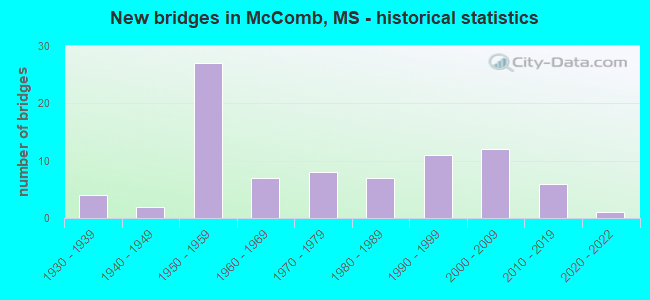
- New bridges - historical statistics
- 41930-1939
- 21940-1949
- 271950-1959
- 71960-1969
- 81970-1979
- 71980-1989
- 111990-1999
- 122000-2009
- 62010-2019
- 12020-2022

- Reconstructed bridges - Historical Statistics
- 21990-1999
- 12000-2009
- 12010-2019


- Bridge Condition - Deck
- 21.4%Very good
- 52.4%Good
- 23.8%Satisfactory
- 2.4%Fair

- Bridge Condition - Superstructure
- 38.1%Very good
- 40.5%Good
- 16.7%Satisfactory
- 4.8%Fair

- Bridge Condition - Substructure
- 42.9%Very good
- 26.2%Good
- 21.4%Satisfactory
- 7.1%Fair
- 2.4%Poor

- Bridge Condition - Channel
- 23.6%Very good
- 36.4%Good
- 23.6%Satisfactory
- 14.5%Fair
- 1.8%Poor

- Bridge Condition - Culverts
- 8.0%Very good
- 68.0%Good
- 20.0%Satisfactory
- 4.0%Fair
Find on map >> Show street view
Structure Number: SA5700000000109, Location: SEC 24 T 3N R 7E (Lat: 31.214750, Lng: -90.453444), Route carried "on" structure: County highway 808, Year Built: 1996, Status: Open, Structure Length: 2.83m (9.28ft), Average Daily Traffic: 85 (year 2021), Average Future Daily Traffic: 120 (year 2043), Design Load: HS 20, Features Intersected: TOWN CREEK, Facility Carried by Structure: SOUTH YARD ROAD
Minimum Vertical Clearance: 30+ m (98+ ft), Kilometerpoint: 0.160, Lanes on structure: 2, Owner: County Highway Agency, Approaching Roadway Width: 7.6m (24.9ft), Material/Design: Concrete, Design/Construction: Channel Beam, Number Of Spans In Main Unit: 3, Length of Maximum Span: 9.4m (30.8ft), Curb or Sidewalk Widths: Left: 0.2m (0.7ft), Right: 0.2m (0.7ft), Curb-To-Curb Width: 7.4m (24.3ft), Out-to-Out Width: 7.8m (25.6ft)
Condition: Deck: Good, Superstructure: Good, Substructure: Satisfactory, Channel: Satisfactory, Operating Rating: 73.8 metric tons, Method Used To Determine Operating Rating: Load Factor (LF), Inventory Rating: 44.1 metric tons, Method Used To Determine Inventory Rating: Load Factor (LF), Structural Evaluation: Equal to present minimum criteria, Deck Geometry: Equal to present minimum criteria, Waterway Adequacy: Better than present minimum criteria, Approach Roadway Alignment: Better than present minimum criteria, Length Of Structure Improvement: 3.75m (12.30ft), Designated Inspection Frequency: Every 24 months, Inspection Date: January 2022, Bridge Improvement Cost: $333,000, Roadway Improvement Cost: $267,000, Total Project Cost: $600,000 ( Estimate for 2022), Deck Structure Type: Concrete Precast Panels
Find on map >> Show street view
Structure Number: SA570000000011, Location: SEC 25 T 3N R 7E B (Lat: 31.203600, Lng: -90.457167), Route carried "on" structure: County highway 57, Year Built: 2008, Status: Open, Structure Length: 3.66m (12.01ft), Average Daily Traffic: 130 (year 2021), Truck Traffic: 8%, Average Future Daily Traffic: 175 (year 2043), Design Load: HS 20, Features Intersected: LITTLE TANGIPAHOA RIVER, Facility Carried by Structure: WARDLAW ROAD
Minimum Vertical Clearance: 30+ m (98+ ft), Kilometerpoint: 0.160, Lanes on structure: 2, Owner: County Highway Agency, Approaching Roadway Width: 8.4m (27.6ft), Material/Design: Concrete, Design/Construction: Channel Beam, Number Of Spans In Main Unit: 3, Length of Maximum Span: 12.2m (40.0ft), Curb-To-Curb Width: 8.6m (28.2ft), Out-to-Out Width: 9.4m (30.8ft)
Condition: Deck: Good, Superstructure: Good, Substructure: Good, Channel: Good, Operating Rating: 81.4 metric tons, Method Used To Determine Operating Rating: Load Factor (LF), Inventory Rating: 48.7 metric tons, Method Used To Determine Inventory Rating: Load Factor (LF), Structural Evaluation: Better than present minimum criteria, Deck Geometry: Equal to present minimum criteria, Waterway Adequacy: Equal to present desirable criteria, Approach Roadway Alignment: Equal to present desirable criteria, Length Of Structure Improvement: 4.58m (15.03ft), Designated Inspection Frequency: Every 24 months, Inspection Date: December 2021, Bridge Improvement Cost: $465,000, Roadway Improvement Cost: $372,000, Total Project Cost: $837,000 ( Estimate for 2021), Deck Structure Type: Concrete Precast Panels
Find on map >> Show street view
Structure Number: SA5700000000114, Location: SEC 6 T 3N R 8E (Lat: 31.248333, Lng: -90.445550), Route carried "on" structure: City street 521, Year Built: 1960, Status: Open, Structure Length: 0.66m (2.17ft), Average Daily Traffic: 620 (year 2021), Truck Traffic: 8%, Average Future Daily Traffic: 930 (year 2043), Design Load: HS 15, Features Intersected: TOWN CREEK, Facility Carried by Structure: N CHERRY STREET
Minimum Vertical Clearance: 30+ m (98+ ft), Kilometerpoint: 0.321, Lanes on structure: 2, Owner: City or Municipal Highway Agency, Approaching Roadway Width: 7.0m (23.0ft), Skew: 3 degrees, Material/Design: Concrete, Design/Construction: Culvert, Number Of Spans In Main Unit: 2, Length of Maximum Span: 3.1m (10.2ft), Curb or Sidewalk Widths: Left: 4.7m (15.4ft), Right: 4.7m (15.4ft), Curb-To-Curb Width: 7.1m (23.3ft), Out-to-Out Width: 16.5m (54.1ft)
Condition: Channel: Good, Culverts: Fair, Operating Rating: 32.7 metric tons, Method Used To Determine Operating Rating: Field evaluation and documented engineering judgment, Inventory Rating: 19.6 metric tons, Method Used To Determine Inventory Rating: Field evaluation and documented engineering judgment, Structural Evaluation: Somewhat better than minimum adequacy, Deck Geometry: Meets minimum limits, Waterway Adequacy: Better than present minimum criteria, Approach Roadway Alignment: Equal to present desirable criteria, Length Of Structure Improvement: 1.29m (4.23ft), Designated Inspection Frequency: Every 24 months, Inspection Date: December 2021, Bridge Improvement Cost: $230,000, Roadway Improvement Cost: $184,000, Total Project Cost: $414,000 ( Estimate for 2021), Wearing Surface/Protective System: Wearing Surface: Bituminous
Find on map >> Show street view
Structure Number: SA5700000000115, Location: SEC 9 T 3N R 8E (Lat: 31.246861, Lng: -90.396167), Route carried "on" structure: County highway 382, Year Built: 2007, Status: Open, Structure Length: 0.70m (2.30ft), Average Daily Traffic: 100 (year 2021), Average Future Daily Traffic: 125 (year 2043), Design Load: HS 20, Features Intersected: SMALL CREEK, Facility Carried by Structure: CHESTER REEVES RD.
Minimum Vertical Clearance: 30+ m (98+ ft), Kilometerpoint: 0.482, Lanes on structure: 2, Owner: County Highway Agency, Approaching Roadway Width: 8.5m (27.9ft), Skew: 3 degrees, Material/Design: Concrete, Design/Construction: Culvert, Number Of Spans In Main Unit: 1, Length of Maximum Span: 5.5m (18.0ft)
Condition: Channel: Very good, Culverts: Good, Operating Rating: 59.4 metric tons, Method Used To Determine Operating Rating: Load Factor (LF), Inventory Rating: 35.5 metric tons, Method Used To Determine Inventory Rating: Load Factor (LF), Structural Evaluation: Better than present minimum criteria, Waterway Adequacy: Better than present minimum criteria, Approach Roadway Alignment: Equal to present desirable criteria, Designated Inspection Frequency: Every 24 months, Inspection Date: Febuary 2020
Find on map >> Show street view
Structure Number: SA5700000000116, Location: SEC 10 T 3N R 8E (Lat: 31.248111, Lng: -90.387167), Route carried "on" structure: County highway 196, Year Built: 1975, Year Reconstructed: 2007, Status: Open, Structure Length: 2.38m (7.81ft), Average Daily Traffic: 245 (year 2021), Truck Traffic: 8%, Average Future Daily Traffic: 380 (year 2043), Design Load: HS 15, Features Intersected: SMALL DRAIN, Facility Carried by Structure: SUMMIT-HOLMESVILLE
Minimum Vertical Clearance: 30+ m (98+ ft), Kilometerpoint: 1.931, Lanes on structure: 2, Owner: County Highway Agency, Approaching Roadway Width: 7.0m (23.0ft), Material/Design: Concrete, Design/Construction: Channel Beam, Number Of Spans In Main Unit: 4, Length of Maximum Span: 5.8m (19.0ft), Curb-To-Curb Width: 7.1m (23.3ft), Out-to-Out Width: 7.5m (24.6ft)
Condition: Deck: Satisfactory, Superstructure: Satisfactory, Substructure: Good, Channel: Very good, Operating Rating: 59.4 metric tons, Method Used To Determine Operating Rating: Load Factor (LF), Inventory Rating: 35.5 metric tons, Method Used To Determine Inventory Rating: Load Factor (LF), Structural Evaluation: Equal to present minimum criteria, Deck Geometry: Meets minimum limits, Waterway Adequacy: Equal to present desirable criteria, Approach Roadway Alignment: Better than present minimum criteria, Length Of Structure Improvement: 3.57m (11.71ft), Designated Inspection Frequency: Every 24 months, Inspection Date: Febuary 2020, Bridge Improvement Cost: $157,000, Roadway Improvement Cost: $126,000, Total Project Cost: $283,000 ( Estimate for 2015), Deck Structure Type: Concrete Precast Panels
Find on map >> Show street view
Structure Number: SA5700000000119, Location: SEC 16 T 3N R 8E (Lat: 31.230333, Lng: -90.405861), Route carried "on" structure: County highway 191, Year Built: 2001, Status: Open, Structure Length: 2.16m (7.09ft), Average Daily Traffic: 300 (year 2021), Truck Traffic: 8%, Average Future Daily Traffic: 300 (year 2043), Design Load: HS 20, Features Intersected: SMALL DRAIN, Facility Carried by Structure: VAN NORMAN CURVE
Minimum Vertical Clearance: 30+ m (98+ ft), Kilometerpoint: 3.701, Lanes on structure: 2, Owner: County Highway Agency, Approaching Roadway Width: 7.9m (25.9ft), Skew: 3 degrees, Material/Design: Concrete, Design/Construction: Channel Beam, Number Of Spans In Main Unit: 3, Length of Maximum Span: 9.4m (30.8ft), Curb or Sidewalk Widths: Left: 0.2m (0.7ft), Right: 0.2m (0.7ft), Curb-To-Curb Width: 8.1m (26.6ft), Out-to-Out Width: 8.6m (28.2ft)
Condition: Deck: Good, Superstructure: Good, Substructure: Good, Channel: Very good, Operating Rating: 75.4 metric tons, Method Used To Determine Operating Rating: Load Factor (LF), Inventory Rating: 45.3 metric tons, Method Used To Determine Inventory Rating: Load Factor (LF), Structural Evaluation: Better than present minimum criteria, Deck Geometry: Somewhat better than minimum adequacy, Waterway Adequacy: Equal to present desirable criteria, Approach Roadway Alignment: Equal to present minimum criteria, Length Of Structure Improvement: 3.24m (10.63ft), Designated Inspection Frequency: Every 24 months, Inspection Date: Febuary 2020, Bridge Improvement Cost: $150,000, Roadway Improvement Cost: $120,000, Total Project Cost: $270,000 ( Estimate for 2019), Deck Structure Type: Concrete Precast Panels
Find on map >> Show street view
Structure Number: SA570000000012, Location: SEC 19 T 3N R 8E (Lat: 31.218194, Lng: -90.444694), Route carried "on" structure: County highway 183, Year Built: 2006, Status: Open, Structure Length: 1.01m (3.31ft), Average Daily Traffic: 125 (year 2021), Truck Traffic: 8%, Average Future Daily Traffic: 200 (year 2043), Design Load: HS 20, Features Intersected: SMALL DRAIN, Facility Carried by Structure: BERTHADALE ROAD
Minimum Vertical Clearance: 30+ m (98+ ft), Kilometerpoint: 0.965, Lanes on structure: 2, Owner: County Highway Agency, Approaching Roadway Width: 7.3m (24.0ft), Skew: 3 degrees, Material/Design: Concrete, Design/Construction: Culvert, Number Of Spans In Main Unit: 2, Length of Maximum Span: 4.9m (16.1ft)
Condition: Channel: Good, Culverts: Good, Operating Rating: 54.6 metric tons, Method Used To Determine Operating Rating: Load Factor (LF), Inventory Rating: 32.7 metric tons, Method Used To Determine Inventory Rating: Load Factor (LF), Structural Evaluation: Better than present minimum criteria, Waterway Adequacy: Better than present minimum criteria, Approach Roadway Alignment: Better than present minimum criteria, Length Of Structure Improvement: 1.68m (5.51ft), Designated Inspection Frequency: Every 24 months, Inspection Date: January 2022, Bridge Improvement Cost: $150,000, Roadway Improvement Cost: $120,000, Total Project Cost: $270,000 ( Estimate for 2022)
Find on map >> Show street view
Structure Number: SA5700000000121, Location: SEC 20 T 3N R 8E B (Lat: 31.211667, Lng: -90.414389), Route carried "on" structure: County highway 50, Year Built: 1935, Status: Open, Structure Length: 0.64m (2.10ft), Average Daily Traffic: 650 (year 2021), Truck Traffic: 8%, Average Future Daily Traffic: 960 (year 2043), Features Intersected: SMALL DRAIN, Facility Carried by Structure: OLD HWY 24
Minimum Vertical Clearance: 30+ m (98+ ft), Kilometerpoint: 13.357, Lanes on structure: 2, Owner: County Highway Agency, Approaching Roadway Width: 7.1m (23.3ft), Material/Design: Concrete, Design/Construction: Culvert, Number Of Spans In Main Unit: 2, Length of Maximum Span: 3.0m (9.8ft)
Condition: Channel: Satisfactory, Culverts: Satisfactory, Operating Rating: 54.6 metric tons, Method Used To Determine Operating Rating: Load Factor (LF), Inventory Rating: 32.7 metric tons, Method Used To Determine Inventory Rating: Load Factor (LF), Structural Evaluation: Equal to present minimum criteria, Waterway Adequacy: Better than present minimum criteria, Approach Roadway Alignment: Equal to present desirable criteria, Length Of Structure Improvement: 1.26m (4.13ft), Designated Inspection Frequency: Every 24 months, Inspection Date: December 2021, Bridge Improvement Cost: $112,000, Roadway Improvement Cost: $90,000, Total Project Cost: $202,000 ( Estimate for 2021)
Find on map >> Show street view
Structure Number: SA570000000015, Location: SEC 30 T 4N R 7E (Lat: 31.286889, Lng: -90.534306), Route carried "on" structure: County highway 22, Year Built: 2004, Status: Open, Structure Length: 2.10m (6.89ft), Average Daily Traffic: 160 (year 2021), Truck Traffic: 8%, Average Future Daily Traffic: 225 (year 2043), Design Load: HS 20, Features Intersected: HAYMANS CREEK, Facility Carried by Structure: WILLIS COTTON ROAD
Minimum Vertical Clearance: 30+ m (98+ ft), Kilometerpoint: 0.321, Lanes on structure: 2, Owner: County Highway Agency, Approaching Roadway Width: 8.3m (27.2ft), Material/Design: Concrete, Design/Construction: Channel Beam, Number Of Spans In Main Unit: 3, Length of Maximum Span: 9.4m (30.8ft), Curb or Sidewalk Widths: Left: 0.2m (0.7ft), Right: 0.2m (0.7ft), Curb-To-Curb Width: 7.4m (24.3ft), Out-to-Out Width: 7.8m (25.6ft)
Condition: Deck: Good, Superstructure: Good, Substructure: Good, Channel: Good, Operating Rating: 70.6 metric tons, Method Used To Determine Operating Rating: Load Factor (LF), Inventory Rating: 42.2 metric tons, Method Used To Determine Inventory Rating: Load Factor (LF), Structural Evaluation: Better than present minimum criteria, Deck Geometry: Somewhat better than minimum adequacy, Waterway Adequacy: Equal to present desirable criteria, Approach Roadway Alignment: Equal to present desirable criteria, Length Of Structure Improvement: 2.88m (9.45ft), Designated Inspection Frequency: Every 24 months, Inspection Date: December 2021, Bridge Improvement Cost: $256,000, Roadway Improvement Cost: $205,000, Total Project Cost: $461,000 ( Estimate for 2021), Deck Structure Type: Concrete Precast Panels
Find on map >> Show street view
Structure Number: SA5700000000151, Location: SEC 34 T 4N R 7E B (Lat: 31.267233, Lng: -90.491467), Route carried "on" structure: County highway 20, Year Built: 1965, Status: Posted for load, Structure Length: 1.16m (3.81ft), Average Daily Traffic: 450 (year 2021), Truck Traffic: 8%, Average Future Daily Traffic: 560 (year 2043), Design Load: H 15, Features Intersected: LITTLE TANGIPAHOA RIVER, Facility Carried by Structure: ENTERPRISE ROAD
Minimum Vertical Clearance: 30+ m (98+ ft), Kilometerpoint: 2.414, Lanes on structure: 2, Owner: City or Municipal Highway Agency, Approaching Roadway Width: 6.1m (20.0ft), Material/Design: Concrete, Design/Construction: Channel Beam, Number Of Spans In Main Unit: 2, Length of Maximum Span: 5.8m (19.0ft), Curb or Sidewalk Widths: Left: 0.2m (0.7ft), Right: 0.2m (0.7ft), Curb-To-Curb Width: 6.0m (19.7ft), Out-to-Out Width: 6.5m (21.3ft)
Condition: Deck: Satisfactory, Superstructure: Fair, Substructure: Satisfactory, Channel: Very good, Operating Rating: 22.6 metric tons, Method Used To Determine Operating Rating: Allowable Stress (AS), Inventory Rating: 11.2 metric tons, Method Used To Determine Inventory Rating: Allowable Stress (AS), Structural Evaluation: Meets minimum limits, Deck Geometry: High priority of replacement, Waterway Adequacy: Equal to present desirable criteria, Approach Roadway Alignment: Better than present minimum criteria, Bridge Posting: Required (Relationship of Operating Rating to Maximum Legal Load: 30.0 - 39.9% below), Length Of Structure Improvement: 1.83m (6.00ft), Designated Inspection Frequency: Every 24 months, Inspection Date: December 2021, Bridge Improvement Cost: $163,000, Roadway Improvement Cost: $131,000, Total Project Cost: $294,000 ( Estimate for 2021), Deck Structure Type: Concrete Precast Panels
Find on map >> Show street view
Structure Number: SA5700000000154, Location: SEC 36 T 4N R 7E B (Lat: 31.264278, Lng: -90.461417), Route carried "on" structure: County highway 7146, Year Built: 1989, Status: Open, Structure Length: 0.75m (2.46ft), Average Daily Traffic: 800 (year 2021), Truck Traffic: 8%, Average Future Daily Traffic: 1,200 (year 2043), Design Load: HS 20, Features Intersected: SMALL STREAM, Facility Carried by Structure: M. L. KING DR EXT.
Minimum Vertical Clearance: 30+ m (98+ ft), Kilometerpoint: 3.420, Lanes on structure: 2, Owner: City or Municipal Highway Agency, Approaching Roadway Width: 11.0m (36.1ft), Material/Design: Concrete, Design/Construction: Culvert, Number Of Spans In Main Unit: 2, Length of Maximum Span: 3.7m (12.1ft)
Condition: Channel: Satisfactory, Culverts: Good, Operating Rating: 45.1 metric tons, Method Used To Determine Operating Rating: Load Factor (LF), Inventory Rating: 27.2 metric tons, Method Used To Determine Inventory Rating: Load Factor (LF), Structural Evaluation: Equal to present minimum criteria, Waterway Adequacy: Equal to present desirable criteria, Approach Roadway Alignment: Equal to present desirable criteria, Length Of Structure Improvement: 1.40m (4.59ft), Designated Inspection Frequency: Every 24 months, Inspection Date: December 2021, Bridge Improvement Cost: $124,000, Roadway Improvement Cost: $100,000, Total Project Cost: $224,000 ( Estimate for 2021), Wearing Surface/Protective System: Wearing Surface: Bituminous
Find on map >> Show street view
Structure Number: SA5700000000164, Location: SEC 32 T 4N R 8E (Lat: 31.270694, Lng: -90.425778), Route carried "on" structure: County highway 199, Year Built: 1997, Status: Open, Structure Length: 2.51m (8.23ft), Average Daily Traffic: 300 (year 2021), Truck Traffic: 8%, Average Future Daily Traffic: 450 (year 2043), Design Load: HS 20, Features Intersected: CLEAR CREEK, Facility Carried by Structure: COLE THOMAS ROAD
Minimum Vertical Clearance: 30+ m (98+ ft), Kilometerpoint: 4.184, Lanes on structure: 2, Owner: County Highway Agency, Approaching Roadway Width: 8.2m (26.9ft), Material/Design: Concrete, Design/Construction: Channel Beam, Number Of Spans In Main Unit: 3, Length of Maximum Span: 9.4m (30.8ft), Curb or Sidewalk Widths: Left: 0.2m (0.7ft), Right: 0.2m (0.7ft), Curb-To-Curb Width: 8.1m (26.6ft), Out-to-Out Width: 8.6m (28.2ft)
Condition: Deck: Good, Superstructure: Very good, Substructure: Satisfactory, Channel: Fair, Operating Rating: 75.7 metric tons, Method Used To Determine Operating Rating: Load Factor (LF), Inventory Rating: 45.3 metric tons, Method Used To Determine Inventory Rating: Load Factor (LF), Structural Evaluation: Equal to present minimum criteria, Deck Geometry: Somewhat better than minimum adequacy, Waterway Adequacy: Better than present minimum criteria, Approach Roadway Alignment: Equal to present desirable criteria, Length Of Structure Improvement: 3.77m (12.37ft), Designated Inspection Frequency: Every 24 months, Inspection Date: Febuary 2020, Bridge Improvement Cost: $174,000, Roadway Improvement Cost: $139,000, Total Project Cost: $313,000 ( Estimate for 2015), Deck Structure Type: Concrete Precast Panels
Find on map >> Show street view
Structure Number: SA5700000000165, Location: SEC 32 T 4N R 8E (Lat: 31.275778, Lng: -90.425639), Route carried "on" structure: County highway 199, Year Built: 1985, Status: Posted for load, Structure Length: 2.32m (7.61ft), Average Daily Traffic: 280 (year 2021), Truck Traffic: 8%, Average Future Daily Traffic: 420 (year 2043), Design Load: H 15, Features Intersected: CLEAR CREEK, Facility Carried by Structure: COLE THOMAS ROAD
Minimum Vertical Clearance: 30+ m (98+ ft), Kilometerpoint: 4.667, Lanes on structure: 2, Owner: County Highway Agency, Approaching Roadway Width: 7.9m (25.9ft), Material/Design: Concrete, Design/Construction: Channel Beam, Number Of Spans In Main Unit: 4, Length of Maximum Span: 5.8m (19.0ft), Curb or Sidewalk Widths: Left: 0.2m (0.7ft), Right: 0.2m (0.7ft), Curb-To-Curb Width: 7.1m (23.3ft), Out-to-Out Width: 7.5m (24.6ft)
Condition: Deck: Good, Superstructure: Good, Substructure: Satisfactory, Channel: Fair, Operating Rating: 26.1 metric tons, Method Used To Determine Operating Rating: Load Factor (LF), Inventory Rating: 15.7 metric tons, Method Used To Determine Inventory Rating: Load Factor (LF), Structural Evaluation: Meets minimum limits, Deck Geometry: Meets minimum limits, Waterway Adequacy: Somewhat better than minimum adequacy, Approach Roadway Alignment: Equal to present desirable criteria, Bridge Posting: Required (Relationship of Operating Rating to Maximum Legal Load: 30.0 - 39.9% below), Length Of Structure Improvement: 3.15m (10.33ft), Designated Inspection Frequency: Every 24 months, Inspection Date: November 2021, Bridge Improvement Cost: $280,000, Roadway Improvement Cost: $224,000, Total Project Cost: $504,000 ( Estimate for 2021), Deck Structure Type: Concrete Precast Panels
Find on map >> Show street view
Structure Number: SA5700000000166, Location: SEC 33 T 4N R 8E (Lat: 31.275194, Lng: -90.395944), Route carried "on" structure: County highway 198, Year Built: 1978, Year Reconstructed: 2016, Status: Open, Structure Length: 3.54m (11.61ft), Average Daily Traffic: 140 (year 2021), Truck Traffic: 8%, Average Future Daily Traffic: 120 (year 2043), Design Load: H 15, Features Intersected: LARGE DRAIN, Facility Carried by Structure: STEWART MILL ROAD
Minimum Vertical Clearance: 30+ m (98+ ft), Kilometerpoint: 0.160, Lanes on structure: 2, Owner: County Highway Agency, Approaching Roadway Width: 6.9m (22.6ft), Material/Design: Concrete, Design/Construction: Channel Beam, Number Of Spans In Main Unit: 6, Length of Maximum Span: 5.8m (19.0ft), Curb or Sidewalk Widths: Left: 0.2m (0.7ft), Right: 0.2m (0.7ft), Curb-To-Curb Width: 7.1m (23.3ft), Out-to-Out Width: 7.5m (24.6ft)
Condition: Deck: Good, Superstructure: Good, Substructure: Satisfactory, Channel: Satisfactory, Operating Rating: 59.4 metric tons, Method Used To Determine Operating Rating: Load Factor (LF), Inventory Rating: 35.6 metric tons, Method Used To Determine Inventory Rating: Load Factor (LF), Structural Evaluation: Equal to present minimum criteria, Deck Geometry: Meets minimum limits, Waterway Adequacy: Equal to present desirable criteria, Approach Roadway Alignment: Equal to present minimum criteria, Length Of Structure Improvement: 3.47m (11.38ft), Designated Inspection Frequency: Every 24 months, Inspection Date: May 2021, Bridge Improvement Cost: $185,000, Roadway Improvement Cost: $65,000, Total Project Cost: $325,000 ( Estimate for 2015), Deck Structure Type: Concrete Precast Panels
Find on map >> Show street view
Structure Number: SA5700000000167, Location: SEC 33 T 4N R 8E (Lat: 31.267194, Lng: -90.407417), Route carried "on" structure: County highway 198, Year Built: 2000, Status: Open, Structure Length: 2.90m (9.51ft), Average Daily Traffic: 210 (year 2021), Truck Traffic: 8%, Average Future Daily Traffic: 285 (year 2043), Design Load: HS 20, Features Intersected: CLEAR CREEK, Facility Carried by Structure: STEWART MILL ROAD
Minimum Vertical Clearance: 30+ m (98+ ft), Kilometerpoint: 1.448, Lanes on structure: 2, Owner: County Highway Agency, Approaching Roadway Width: 8.2m (26.9ft), Skew: 3 degrees, Material/Design: Concrete, Design/Construction: Channel Beam, Number Of Spans In Main Unit: 3, Length of Maximum Span: 9.4m (30.8ft), Curb or Sidewalk Widths: Left: 0.2m (0.7ft), Right: 0.2m (0.7ft), Curb-To-Curb Width: 8.1m (26.6ft), Out-to-Out Width: 8.6m (28.2ft)
Condition: Deck: Good, Superstructure: Very good, Substructure: Good, Channel: Satisfactory, Operating Rating: 75.4 metric tons, Method Used To Determine Operating Rating: Load Factor (LF), Inventory Rating: 45.3 metric tons, Method Used To Determine Inventory Rating: Load Factor (LF), Structural Evaluation: Better than present minimum criteria, Deck Geometry: Somewhat better than minimum adequacy, Waterway Adequacy: Equal to present desirable criteria, Approach Roadway Alignment: Equal to present minimum criteria, Length Of Structure Improvement: 4.35m (14.27ft), Designated Inspection Frequency: Every 24 months, Inspection Date: Febuary 2020, Bridge Improvement Cost: $201,000, Roadway Improvement Cost: $161,000, Total Project Cost: $362,000 ( Estimate for 2015), Deck Structure Type: Concrete Precast Panels
Find on map >> Show street view
Structure Number: SA5700000000182, Location: SEC 23 T 3N R 7E (Lat: 31.218333, Lng: -90.465917), Route carried "on" structure: City street 810, Year Built: 1976, Status: Closed, Structure Length: 1.16m (3.81ft), Average Daily Traffic: 60 (year 2021), Average Future Daily Traffic: 90 (year 2043), Design Load: H 10, Features Intersected: SMALL CREEK, Facility Carried by Structure: HAMILTON STREET
Minimum Vertical Clearance: 30+ m (98+ ft), Kilometerpoint: 0.180, Lanes on structure: 2, Owner: City or Municipal Highway Agency, Approaching Roadway Width: 4.6m (15.1ft), Skew: 1 degrees, Material/Design: Wood or Timber, Design/Construction: Stringer/Multi-beam, Number Of Spans In Main Unit: 2, Length of Maximum Span: 5.8m (19.0ft), Curb or Sidewalk Widths: Left: 0.1m (0.3ft), Right: 0.1m (0.3ft), Curb-To-Curb Width: 6.0m (19.7ft), Out-to-Out Width: 6.2m (20.3ft)
Condition: Deck: Satisfactory, Superstructure: Satisfactory, Substructure: Fair, Channel: Poor, Deck Geometry: Meets minimum limits, Waterway Adequacy: Better than present minimum criteria, Approach Roadway Alignment: Equal to present minimum criteria, Bridge Posting: Required (Relationship of Operating Rating to Maximum Legal Load: > 39.9% below), Length Of Structure Improvement: 1.74m (5.71ft), Designated Inspection Frequency: Every 12 months, Inspection Date: Febuary 2021, Bridge Improvement Cost: $117,000, Roadway Improvement Cost: $94,000, Total Project Cost: $211,000 ( Estimate for 2021), Deck Structure Type: Wood or Timber, Wearing Surface/Protective System: Wearing Surface: Bituminous
Find on map >> Show street view
Structure Number: SA5700000000185, Location: SEC 7 T 3N R 8E (Lat: 31.240028, Lng: -90.439250), Route carried "on" structure: Business City street 7134, Year Built: 1975, Status: Open, Structure Length: 0.78m (2.56ft), Average Daily Traffic: 470 (year 2021), Truck Traffic: 8%, Average Future Daily Traffic: 560 (year 2043), Design Load: HS 20+Mod, Features Intersected: SMALL DRAIN, Facility Carried by Structure: SOUTH LOCUST ST.
Minimum Vertical Clearance: 30+ m (98+ ft), Kilometerpoint: 0.836, Lanes on structure: 2, Owner: City or Municipal Highway Agency, Approaching Roadway Width: 12.2m (40.0ft), Material/Design: Concrete, Design/Construction: Culvert, Number Of Spans In Main Unit: 2, Length of Maximum Span: 3.7m (12.1ft)
Condition: Channel: Fair, Culverts: Satisfactory, Operating Rating: 54.5 metric tons, Method Used To Determine Operating Rating: Load Factor (LF), Inventory Rating: 32.6 metric tons, Method Used To Determine Inventory Rating: Load Factor (LF), Structural Evaluation: Equal to present minimum criteria, Waterway Adequacy: Somewhat better than minimum adequacy, Approach Roadway Alignment: Equal to present desirable criteria, Length Of Structure Improvement: 1.16m (3.81ft), Designated Inspection Frequency: Every 24 months, Inspection Date: Febuary 2020, Bridge Improvement Cost: $380,000, Roadway Improvement Cost: $130,000, Total Project Cost: $510,000 ( Estimate for 2015)
Find on map >> Show street view
Structure Number: SA5700000000186, Location: SEC 1 T 3N R 7E (Lat: 31.248500, Lng: -90.449806), Route carried "on" structure: Business City street 9255, Year Built: 2009, Status: Open, Structure Length: 0.88m (2.89ft), Average Daily Traffic: 460 (year 2021), Truck Traffic: 8%, Average Future Daily Traffic: 560 (year 2043), Design Load: HS 20+Mod, Features Intersected: SMALL DRAIN, Facility Carried by Structure: MICHIGAN AVE.
Minimum Vertical Clearance: 30+ m (98+ ft), Kilometerpoint: 0.195, Lanes on structure: 2, Owner: City or Municipal Highway Agency, Approaching Roadway Width: 6.7m (22.0ft), Material/Design: Concrete, Design/Construction: Culvert, Number Of Spans In Main Unit: 2, Length of Maximum Span: 3.7m (12.1ft), Curb-To-Curb Width: 7.3m (24.0ft), Out-to-Out Width: 14.3m (46.9ft)
Condition: Channel: Good, Culverts: Good, Operating Rating: 54.5 metric tons, Method Used To Determine Operating Rating: Load Factor (LF), Inventory Rating: 32.6 metric tons, Method Used To Determine Inventory Rating: Load Factor (LF), Structural Evaluation: Better than present minimum criteria, Deck Geometry: Meets minimum limits, Waterway Adequacy: Equal to present minimum criteria, Approach Roadway Alignment: Meets minimum limits, Designated Inspection Frequency: Every 24 months, Inspection Date: Febuary 2020
Find on map >> Show street view
Structure Number: SA5700000000187, Location: SEC 1 T 3N R 7E (Lat: 31.249361, Lng: -90.451000), Route carried "on" structure: Business City street 439, Year Built: 2009, Status: Open, Structure Length: 1.00m (3.28ft), Average Daily Traffic: 460 (year 2021), Truck Traffic: 8%, Average Future Daily Traffic: 560 (year 2043), Design Load: HS 20+Mod, Features Intersected: SMALL DRAIN, Facility Carried by Structure: NEW YORK AVE.
Minimum Vertical Clearance: 30+ m (98+ ft), Kilometerpoint: 0.053, Lanes on structure: 2, Owner: City or Municipal Highway Agency, Approaching Roadway Width: 6.4m (21.0ft), Skew: 3 degrees, Material/Design: Concrete, Design/Construction: Culvert, Number Of Spans In Main Unit: 2, Length of Maximum Span: 4.2m (13.8ft), Curb-To-Curb Width: 6.7m (22.0ft), Out-to-Out Width: 14.2m (46.6ft)
Condition: Channel: Very good, Culverts: Good, Operating Rating: 54.5 metric tons, Method Used To Determine Operating Rating: Load Factor (LF), Inventory Rating: 32.6 metric tons, Method Used To Determine Inventory Rating: Load Factor (LF), Structural Evaluation: Better than present minimum criteria, Deck Geometry: Meets minimum limits, Waterway Adequacy: Equal to present minimum criteria, Approach Roadway Alignment: Better than present minimum criteria, Designated Inspection Frequency: Every 24 months, Inspection Date: Febuary 2020, Wearing Surface/Protective System: Wearing Surface: Bituminous
Find on map >> Show street view
Structure Number: SA5700000000188, Location: SEC 1 T 3N R 7E (Lat: 31.250417, Lng: -90.452944), Route carried "on" structure: Business City street 9257, Year Built: 2009, Status: Open, Structure Length: 0.87m (2.85ft), Average Daily Traffic: 470 (year 2021), Truck Traffic: 8%, Average Future Daily Traffic: 560 (year 2043), Design Load: HS 20+Mod, Features Intersected: SMALL DRAIN, Facility Carried by Structure: GEORGIA AVE.
Minimum Vertical Clearance: 30+ m (98+ ft), Kilometerpoint: 0.185, Lanes on structure: 2, Owner: City or Municipal Highway Agency, Approaching Roadway Width: 10.1m (33.1ft), Material/Design: Concrete, Design/Construction: Culvert, Number Of Spans In Main Unit: 2, Length of Maximum Span: 3.7m (12.1ft), Curb-To-Curb Width: 11.9m (39.0ft), Out-to-Out Width: 16.6m (54.5ft)
Condition: Channel: Very good, Culverts: Satisfactory, Operating Rating: 54.5 metric tons, Method Used To Determine Operating Rating: Load Factor (LF), Inventory Rating: 32.6 metric tons, Method Used To Determine Inventory Rating: Load Factor (LF), Structural Evaluation: Equal to present minimum criteria, Deck Geometry: Better than present minimum criteria, Waterway Adequacy: Equal to present desirable criteria, Approach Roadway Alignment: Equal to present minimum criteria, Designated Inspection Frequency: Every 24 months, Inspection Date: Febuary 2020, Wearing Surface/Protective System: Wearing Surface: Bituminous
Find on map >> Show street view
Structure Number: SA5700000000189, Location: SEC 1 T 3N R 7E (Lat: 31.250083, Lng: -90.452306), Route carried "on" structure: Business City street 7146, Year Built: 2009, Status: Open, Structure Length: 0.90m (2.95ft), Average Daily Traffic: 500 (year 2021), Truck Traffic: 8%, Average Future Daily Traffic: 700 (year 2043), Design Load: HS 20+Mod, Features Intersected: SMALL DRAIN, Facility Carried by Structure: SUMMIT ST.
Minimum Vertical Clearance: 30+ m (98+ ft), Kilometerpoint: 0.495, Lanes on structure: 2, Owner: City or Municipal Highway Agency, Approaching Roadway Width: 10.1m (33.1ft), Material/Design: Concrete, Design/Construction: Culvert, Number Of Spans In Main Unit: 2, Length of Maximum Span: 3.7m (12.1ft), Curb-To-Curb Width: 11.6m (38.1ft), Out-to-Out Width: 25.0m (82.0ft)
Condition: Channel: Very good, Culverts: Good, Operating Rating: 54.5 metric tons, Method Used To Determine Operating Rating: Load Factor (LF), Inventory Rating: 32.6 metric tons, Method Used To Determine Inventory Rating: Load Factor (LF), Structural Evaluation: Better than present minimum criteria, Deck Geometry: Better than present minimum criteria, Waterway Adequacy: Equal to present desirable criteria, Approach Roadway Alignment: Equal to present desirable criteria, Length Of Structure Improvement: 1.16m (3.81ft), Designated Inspection Frequency: Every 24 months, Inspection Date: Febuary 2020, Bridge Improvement Cost: $380,000, Roadway Improvement Cost: $130,000, Total Project Cost: $510,000 ( Estimate for 2015)
Find on map >> Show street view
Structure Number: SA570000000A104, Location: SEC 14 T 3N R 7E (Lat: 31.220778, Lng: -90.466694), Route carried "on" structure: City street 810, Year Built: 2018, Status: Open, Structure Length: 1.04m (3.41ft), Average Daily Traffic: 65 (year 2018), Average Future Daily Traffic: 75 (year 2038), Features Intersected: SMALL STREAM, Facility Carried by Structure: SCHOOL STREET
Minimum Vertical Clearance: 30+ m (98+ ft), Kilometerpoint: 0.010, Lanes on structure: 2, Owner: City or Municipal Highway Agency, Approaching Roadway Width: 6.1m (20.0ft), Material/Design: Steel, Design/Construction: Culvert, Number Of Spans In Main Unit: 3, Length of Maximum Span: 2.7m (8.9ft)
Condition: Channel: Good, Culverts: Good, Operating Rating: 32.7 metric tons, Method Used To Determine Operating Rating: Field evaluation and documented engineering judgment, Inventory Rating: 19.6 metric tons, Method Used To Determine Inventory Rating: Field evaluation and documented engineering judgment, Structural Evaluation: Somewhat better than minimum adequacy, Waterway Adequacy: Better than present minimum criteria, Approach Roadway Alignment: Equal to present minimum criteria, Length Of Structure Improvement: 1.56m (5.12ft), Designated Inspection Frequency: Every 24 months, Inspection Date: October 2020, Bridge Improvement Cost: $60,000, Roadway Improvement Cost: $48,000, Total Project Cost: $108,000 ( Estimate for 2020)
Find on map >> Show street view
Structure Number: SA570000000A108, Location: SEC 23 T 3N R 7E (Lat: 31.213556, Lng: -90.467611), Route carried "on" structure: County highway 7132, Year Built: 2015, Status: Open, Structure Length: 2.37m (7.78ft), Average Daily Traffic: 130 (year 2021), Truck Traffic: 8%, Average Future Daily Traffic: 150 (year 2043), Design Load: HS 20, Features Intersected: LITTLE TANGIPAHOA RIVER, Facility Carried by Structure: HOLDEN ROAD
Minimum Vertical Clearance: 30+ m (98+ ft), Kilometerpoint: 1.068, Lanes on structure: 2, Owner: County Highway Agency, Approaching Roadway Width: 6.7m (22.0ft), Material/Design: Concrete, Design/Construction: Channel Beam, Number Of Spans In Main Unit: 4, Length of Maximum Span: 5.8m (19.0ft), Curb-To-Curb Width: 7.0m (23.0ft), Out-to-Out Width: 7.5m (24.6ft)
Condition: Deck: Satisfactory, Superstructure: Satisfactory, Substructure: Satisfactory, Channel: Satisfactory, Operating Rating: 70.5 metric tons, Method Used To Determine Operating Rating: Load Factor (LF), Inventory Rating: 42.1 metric tons, Method Used To Determine Inventory Rating: Load Factor (LF), Structural Evaluation: Equal to present minimum criteria, Deck Geometry: Meets minimum limits, Waterway Adequacy: Equal to present desirable criteria, Approach Roadway Alignment: Equal to present desirable criteria, Length Of Structure Improvement: 3.56m (11.68ft), Designated Inspection Frequency: Every 24 months, Inspection Date: Febuary 2020, Bridge Improvement Cost: $157,000, Roadway Improvement Cost: $126,000, Total Project Cost: $283,000 ( Estimate for 2015), Deck Structure Type: Concrete Precast Panels
Find on map >> Show street view
Structure Number: SA570000000A111, Location: SEC_25_T 3N_R 7E B (Lat: 31.203833, Lng: -90.451472), Route carried "on" structure: County highway 58, Year Built: 2015, Status: Open, Structure Length: 3.16m (10.37ft), Average Daily Traffic: 80 (year 2021), Average Future Daily Traffic: 120 (year 2043), Design Load: HL 93, Features Intersected: TOWN CREEK, Facility Carried by Structure: ADAMS ROAD
Minimum Vertical Clearance: 30+ m (98+ ft), Kilometerpoint: 2.092, Lanes on structure: 2, Owner: County Highway Agency, Approaching Roadway Width: 6.1m (20.0ft), Material/Design: Concrete, Design/Construction: Channel Beam, Number Of Spans In Main Unit: 3, Length of Maximum Span: 12.2m (40.0ft), Curb-To-Curb Width: 8.5m (27.9ft), Out-to-Out Width: 9.4m (30.8ft)
Condition: Deck: Very good, Superstructure: Very good, Substructure: Good, Channel: Fair, Operating Rating: 43.7 metric tons, Method Used To Determine Operating Rating: Load and Resistance Factor Rating (LRFR) rating reported by rating factor(RF) method using HL-93 loadings, Inventory Rating: 33.7 metric tons, Method Used To Determine Inventory Rating: Load and Resistance Factor Rating (LRFR) rating reported by rating factor(RF) method using HL-93 loadings, Structural Evaluation: Better than present minimum criteria, Deck Geometry: Better than present minimum criteria, Waterway Adequacy: Equal to present desirable criteria, Approach Roadway Alignment: Equal to present desirable criteria, Length Of Structure Improvement: 4.02m (13.19ft), Designated Inspection Frequency: Every 24 months, Inspection Date: May 2021, Bridge Improvement Cost: $407,000, Roadway Improvement Cost: $326,000, Total Project Cost: $733,000 ( Estimate for 2021), Deck Structure Type: Concrete Precast Panels
Find on map >> Show street view
Structure Number: SA570000000A118, Location: SEC 15 T 3N R 8E B (Lat: 31.233306, Lng: -90.386583), Route carried "on" structure: County highway 190, Year Built: 2013, Status: Open, Structure Length: 0.61m (2.00ft), Average Daily Traffic: 330 (year 2021), Truck Traffic: 8%, Average Future Daily Traffic: 495 (year 2043), Design Load: HL 93, Features Intersected: LARGE DRAIN, Facility Carried by Structure: MCCOMB-HOLMESVILLE
Minimum Vertical Clearance: 30+ m (98+ ft), Kilometerpoint: 4.828, Lanes on structure: 2, Owner: County Highway Agency, Approaching Roadway Width: 6.4m (21.0ft), Skew: 1 degrees, Material/Design: Steel, Design/Construction: Culvert, Number Of Spans In Main Unit: 2, Length of Maximum Span: 2.7m (8.9ft)
Condition: Channel: Satisfactory, Culverts: Good, Inventory Rating: 97.2 metric tons, Method Used To Determine Inventory Rating: Load and Resistance Factor Rating (LRFR) rating reported by rating factor(RF) method using HL-93 loadings, Structural Evaluation: Better than present minimum criteria, Waterway Adequacy: Equal to present desirable criteria, Approach Roadway Alignment: Better than present minimum criteria, Length Of Structure Improvement: 1.22m (4.00ft), Designated Inspection Frequency: Every 24 months, Inspection Date: Febuary 2020, Bridge Improvement Cost: $121,000, Roadway Improvement Cost: $97,000, Total Project Cost: $218,000 ( Estimate for 2021)
Find on map >> Show street view
Structure Number: SA570000000A122, Location: SEC 20 T 3N R 8E (Lat: 31.206722, Lng: -90.421194), Route carried "on" structure: County highway 175, Year Built: 2020, Status: Open, Structure Length: 2.16m (7.09ft), Average Daily Traffic: 125 (year 2021), Truck Traffic: 8%, Average Future Daily Traffic: 105 (year 2043), Design Load: HL 93, Features Intersected: SMALL DRAIN, Facility Carried by Structure: MCKENZIE ROAD
Minimum Vertical Clearance: 30+ m (98+ ft), Kilometerpoint: 3.701, Lanes on structure: 2, Owner: County Highway Agency, Approaching Roadway Width: 7.0m (23.0ft), Material/Design: Concrete, Design/Construction: Channel Beam, Number Of Spans In Main Unit: 3, Length of Maximum Span: 9.4m (30.8ft), Curb or Sidewalk Widths: Left: 0.2m (0.7ft), Right: 0.2m (0.7ft), Curb-To-Curb Width: 8.1m (26.6ft), Out-to-Out Width: 8.6m (28.2ft)
Condition: Deck: Very good, Superstructure: Very good, Substructure: Very good, Channel: Very good, Operating Rating: 43.7 metric tons, Method Used To Determine Operating Rating: Load and Resistance Factor Rating (LRFR) rating reported by rating factor(RF) method using HL-93 loadings, Inventory Rating: 33.7 metric tons, Method Used To Determine Inventory Rating: Load and Resistance Factor Rating (LRFR) rating reported by rating factor(RF) method using HL-93 loadings, Structural Evaluation: Equal to present desirable criteria, Deck Geometry: Somewhat better than minimum adequacy, Waterway Adequacy: Equal to present desirable criteria, Approach Roadway Alignment: Equal to present minimum criteria, Length Of Structure Improvement: 3.24m (10.63ft), Designated Inspection Frequency: Every 24 months, Inspection Date: March 2020, Bridge Improvement Cost: $150,000, Roadway Improvement Cost: $120,000, Total Project Cost: $270,000 ( Estimate for 2020), Deck Structure Type: Concrete Precast Panels
Find on map >> Show street view
Structure Number: 11000550570154A, Location: I 55 OVER SR 24/US 98EB (Lat: 31.221150, Lng: -90.483081), Route carried "under" structure: State highway 24, Year Built: 1959, Structure Length: 0. m, Average Daily Traffic: 3,000 (year 2017), Truck Traffic: 5%, Features Intersected: SR 24/US 98 EAST, Facility Carried by Structure: I 55
Minimum Vertical Clearance: 5.06m (16.60ft), Kilometerpoint: 16.316, Lanes on structure: 3, Lanes under structure: 6, Material/Design: Concrete continuous, Design/Construction: Box Beam or Girders - Single/Spread, Length of Maximum Span: 20.4m (66.9ft)
Find on map >> Show street view
Structure Number: 11000550570154A, Location: I 55 OVER SR 24/US 98EB (Lat: 31.221011, Lng: -90.483100), Route carried "under" structure: State highway 24, Year Built: 1959, Structure Length: 0. m, Average Daily Traffic: 3,000 (year 2017), Truck Traffic: 5%, Features Intersected: SR 24/US 98 EAST, Facility Carried by Structure: I 55
Minimum Vertical Clearance: 5.14m (16.86ft), Kilometerpoint: 8.295, Lanes on structure: 3, Lanes under structure: 6, Material/Design: Concrete continuous, Design/Construction: Box Beam or Girders - Single/Spread, Length of Maximum Span: 20.4m (66.9ft)
Find on map >> Show street view
Structure Number: 11000550570154B, Location: I 55 OVER SR 24/US 98EB (Lat: 31.221219, Lng: -90.482800), Route carried "under" structure: State highway 24, Year Built: 1959, Structure Length: 0. m, Average Daily Traffic: 3,000 (year 2017), Truck Traffic: 5%, Features Intersected: SR 24/US 98 EAST, Facility Carried by Structure: I 55
Minimum Vertical Clearance: 5.11m (16.77ft), Kilometerpoint: 16.288, Lanes on structure: 3, Lanes under structure: 6, Material/Design: Concrete continuous, Design/Construction: Box Beam or Girders - Single/Spread, Length of Maximum Span: 20.4m (66.9ft)
Find on map >> Show street view
Structure Number: 11000550570154B, Location: I 55 OVER SR 24/US 98EB (Lat: 31.221081, Lng: -90.482819), Route carried "under" structure: State highway 24, Year Built: 1959, Structure Length: 0. m, Average Daily Traffic: 3,000 (year 2017), Truck Traffic: 5%, Features Intersected: SR 24/US 98 EAST, Facility Carried by Structure: I 55
Minimum Vertical Clearance: 5.26m (17.26ft), Kilometerpoint: 8.322, Lanes on structure: 3, Lanes under structure: 6, Material/Design: Concrete continuous, Design/Construction: Box Beam or Girders - Single/Spread, Length of Maximum Span: 20.4m (66.9ft)
Find on map >> Show street view
Structure Number: 11000550570180A, Location: I 55 OVER SR 570 (Lat: 31.259989, Lng: -90.479331), Route carried "under" structure: State highway 570, Year Built: 1959, Structure Length: 0. m, Average Daily Traffic: 2,000 (year 2017), Truck Traffic: 5%, Features Intersected: SR 570, Facility Carried by Structure: I 55
Minimum Vertical Clearance: 5.33m (17.49ft), Kilometerpoint: 0.293, Lanes on structure: 2, Lanes under structure: 4, Material/Design: Concrete continuous, Design/Construction: Box Beam or Girders - Single/Spread, Length of Maximum Span: 20.4m (66.9ft)
Find on map >> Show street view
Structure Number: 11000550570180A, Location: I 55 OVER SR 570 (Lat: 31.259839, Lng: -90.479331), Route carried "under" structure: State highway 570, Year Built: 1959, Structure Length: 0. m, Average Daily Traffic: 2,000 (year 2017), Truck Traffic: 5%, Features Intersected: SR 570, Facility Carried by Structure: I 55
Minimum Vertical Clearance: 5.36m (17.59ft), Kilometerpoint: 6.914, Lanes on structure: 2, Lanes under structure: 4, Material/Design: Concrete continuous, Design/Construction: Box Beam or Girders - Single/Spread, Length of Maximum Span: 20.4m (66.9ft)
Find on map >> Show street view
Structure Number: 11000550570180B, Location: I 55 OVER SR 570 (Lat: 31.260061, Lng: -90.479061), Route carried "under" structure: State highway 570, Year Built: 1959, Structure Length: 0. m, Average Daily Traffic: 5,500 (year 2017), Truck Traffic: 5%, Features Intersected: SR 570, Facility Carried by Structure: I 55
Minimum Vertical Clearance: 4.63m (15.19ft), Kilometerpoint: 0.267, Lanes on structure: 2, Lanes under structure: 4, Material/Design: Concrete continuous, Design/Construction: Box Beam or Girders - Single/Spread, Length of Maximum Span: 20.4m (66.9ft)
Find on map >> Show street view
Structure Number: 11000550570180B, Location: I 55 OVER SR 570 (Lat: 31.259919, Lng: -90.479061), Route carried "under" structure: State highway 570, Year Built: 1959, Structure Length: 0. m, Average Daily Traffic: 5,500 (year 2017), Truck Traffic: 5%, Features Intersected: SR 570, Facility Carried by Structure: I 55
Minimum Vertical Clearance: 4.67m (15.32ft), Kilometerpoint: 6.941, Lanes on structure: 2, Lanes under structure: 4, Material/Design: Concrete continuous, Design/Construction: Box Beam or Girders - Single/Spread, Length of Maximum Span: 20.4m (66.9ft)
Find on map >> Show street view
Structure Number: 41000550570149, Location: 4.4 MI N SR 48 (Lat: 31.213550, Lng: -90.483800), Route carried "under" structure: Interstate 55, Year Built: 1960, Structure Length: 0. m, Average Daily Traffic: 12,000 (year 2017), Truck Traffic: 10%, Features Intersected: I 55, Facility Carried by Structure: OLD LIBERTY ROAD
Minimum Vertical Clearance: 5.13m (16.83ft), Kilometerpoint: 15.076, Lanes on structure: 2, Lanes under structure: 4, Material/Design: Concrete continuous, Design/Construction: Box Beam or Girders - Single/Spread, Length of Maximum Span: 24.4m (80.1ft)
Find on map >> Show street view
Structure Number: 41000550570149, Location: 4.4 MI N SR 48 (Lat: 31.213681, Lng: -90.483539), Route carried "under" structure: Interstate 55, Year Built: 1960, Structure Length: 0. m, Average Daily Traffic: 12,000 (year 2017), Truck Traffic: 10%, Features Intersected: I 55, Facility Carried by Structure: OLD LIBERTY ROAD
Minimum Vertical Clearance: 4.94m (16.21ft), Kilometerpoint: 23.915, Lanes on structure: 2, Lanes under structure: 4, Material/Design: Concrete continuous, Design/Construction: Box Beam or Girders - Single/Spread, Length of Maximum Span: 24.4m (80.1ft)
Find on map >> Show street view
Structure Number: 41000550570165, Location: 1.1 MI N US 98/SR 24 (Lat: 31.238031, Lng: -90.480969), Route carried "under" structure: Interstate 55, Year Built: 1959, Structure Length: 0. m, Average Daily Traffic: 17,000 (year 2017), Truck Traffic: 10%, Features Intersected: I 55, Facility Carried by Structure: PARK DRIVE
Minimum Vertical Clearance: 4.91m (16.11ft), Kilometerpoint: 26.625, Lanes on structure: 2, Lanes under structure: 4, Material/Design: Concrete continuous, Design/Construction: Box Beam or Girders - Single/Spread, Length of Maximum Span: 24.4m (80.1ft)
Find on map >> Show street view
Structure Number: 41000550570165, Location: 1.1 MI N US 98/SR 24 (Lat: 31.237889, Lng: -90.481261), Route carried "under" structure: Interstate 55, Year Built: 1959, Structure Length: 0. m, Average Daily Traffic: 17,000 (year 2017), Truck Traffic: 10%, Features Intersected: I 55, Facility Carried by Structure: PARK DRIVE
Minimum Vertical Clearance: 4.97m (16.31ft), Kilometerpoint: 12.368, Lanes on structure: 2, Lanes under structure: 4, Material/Design: Concrete continuous, Design/Construction: Box Beam or Girders - Single/Spread, Length of Maximum Span: 24.4m (80.1ft)
Find on map >> Show street view
Structure Number: 51000550570172, Location: 1.8 MI N US 98/SR 24 (Lat: 31.247869, Lng: -90.480169), Route carried "under" structure: Interstate 55, Year Built: 1959, Structure Length: 0. m, Average Daily Traffic: 9,500 (year 2017), Truck Traffic: 10%, Features Intersected: I 55, Facility Carried by Structure: DELAWARE AVENUE
Minimum Vertical Clearance: 4.72m (15.49ft), Kilometerpoint: 11.256, Lanes on structure: 2, Lanes under structure: 4, Material/Design: Concrete continuous, Design/Construction: Box Beam or Girders - Single/Spread, Length of Maximum Span: 24.4m (80.1ft)
Find on map >> Show street view
Structure Number: 51000550570172, Location: 1.8 MI N US 98/SR 24 (Lat: 31.247819, Lng: -90.479911), Route carried "under" structure: Interstate 55, Year Built: 1959, Structure Length: 0. m, Average Daily Traffic: 9,500 (year 2017), Truck Traffic: 10%, Features Intersected: I 55, Facility Carried by Structure: DELAWARE AVENUE
Minimum Vertical Clearance: 4.65m (15.26ft), Kilometerpoint: 27.716, Lanes on structure: 2, Lanes under structure: 4, Material/Design: Concrete continuous, Design/Construction: Box Beam or Girders - Single/Spread, Length of Maximum Span: 24.4m (80.1ft)
Find on map >> Show street view
Structure Number: 5100055057019, Location: 1.0 MI N SR 570 (Lat: 31.273981, Lng: -90.478839), Route carried "under" structure: Interstate 55, Year Built: 1959, Structure Length: 0. m, Average Daily Traffic: 1,750 (year 2017), Truck Traffic: 10%, Features Intersected: I 55, Facility Carried by Structure: ENTERPRISE ROAD
Minimum Vertical Clearance: 4.89m (16.04ft), Kilometerpoint: 30.619, Lanes on structure: 2, Lanes under structure: 4, Material/Design: Concrete continuous, Design/Construction: Box Beam or Girders - Single/Spread, Length of Maximum Span: 24.4m (80.1ft)
Find on map >> Show street view
Structure Number: 5100055057019, Location: 1.0 MI N SR 570 (Lat: 31.273819, Lng: -90.479111), Route carried "under" structure: Interstate 55, Year Built: 1959, Structure Length: 0. m, Average Daily Traffic: 11,500 (year 2017), Truck Traffic: 10%, Features Intersected: I 55, Facility Carried by Structure: ENTERPRISE ROAD
Minimum Vertical Clearance: 4.89m (16.04ft), Kilometerpoint: 8.375, Lanes on structure: 2, Lanes under structure: 4, Material/Design: Concrete continuous, Design/Construction: Box Beam or Girders - Single/Spread, Length of Maximum Span: 24.4m (80.1ft)
Find on map >> Show street view
Structure Number: 51000550570197, Location: 1.7 MI N SR 570 (Lat: 31.284189, Lng: -90.478900), Route carried "under" structure: Interstate 55, Year Built: 1959, Structure Length: 0. m, Average Daily Traffic: 11,500 (year 2017), Truck Traffic: 10%, Features Intersected: I 55, Facility Carried by Structure: ROBB STREET
Minimum Vertical Clearance: 4.95m (16.24ft), Kilometerpoint: 7.226, Lanes on structure: 2, Lanes under structure: 4, Material/Design: Concrete continuous, Design/Construction: Box Beam or Girders - Single/Spread, Length of Maximum Span: 20.4m (66.9ft)
Find on map >> Show street view
Structure Number: 51000550570197, Location: 1.7 MI N SR 570 (Lat: 31.284189, Lng: -90.478631), Route carried "under" structure: Interstate 55, Year Built: 1959, Structure Length: 0. m, Average Daily Traffic: 11,500 (year 2017), Truck Traffic: 8%, Features Intersected: I 55, Facility Carried by Structure: ROBB STREET
Minimum Vertical Clearance: 4.93m (16.17ft), Kilometerpoint: 31.751, Lanes on structure: 2, Lanes under structure: 4, Material/Design: Concrete continuous, Design/Construction: Box Beam or Girders - Single/Spread, Length of Maximum Span: 20.4m (66.9ft)