Bridge Statistics for Montgomery, Alabama (AL)
Condition, Traffic, Stress, Structural Evaluation, Project Costs
- National Bridge Inventory (NBI) Statistics
- 464Number of bridges
- 8,547ft / 2,605mTotal length
- $1,263,763,000Total costs
- 8,220,647Total average daily traffic
- 853,526Total average daily truck traffic
- National Bridge Inventory (NBI) Registered Bridges for Montgomery
- No street view available for this location
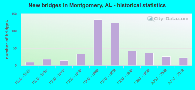
- New bridges - historical statistics
- 11910-1919
- 101920-1929
- 181930-1939
- 151940-1949
- 331950-1959
- 1331960-1969
- 1241970-1979
- 431980-1989
- 371990-1999
- 262000-2009
- 232010-2019
- 12020-2022
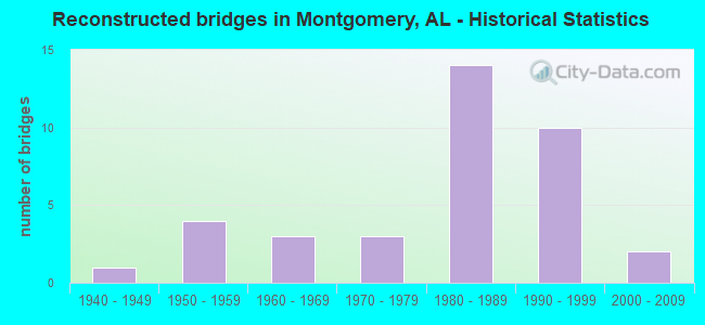
- Reconstructed bridges - Historical Statistics
- 11940-1949
- 41950-1959
- 31960-1969
- 31970-1979
- 141980-1989
- 101990-1999
- 22000-2009
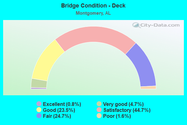
- Bridge Condition - Deck
- 0.8%Excellent
- 4.7%Very good
- 23.5%Good
- 44.7%Satisfactory
- 24.7%Fair
- 1.6%Poor
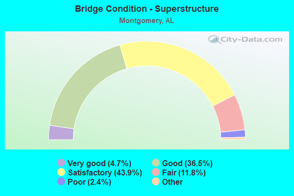
- Bridge Condition - Superstructure
- 4.7%Excellent
- 36.5%Very good
- 43.9%Good
- 11.8%Satisfactory
- 2.4%Fair
- 0.8%Poor
- 0.4%Serious
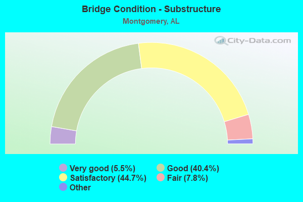
- Bridge Condition - Substructure
- 5.5%Excellent
- 40.4%Very good
- 44.7%Good
- 7.8%Satisfactory
- 1.6%Fair
- 0.8%Poor
- 0.4%Serious
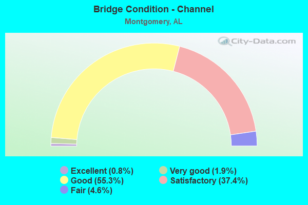
- Bridge Condition - Channel
- 0.8%Excellent
- 1.9%Very good
- 55.3%Good
- 37.4%Satisfactory
- 4.6%Fair
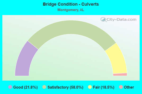
- Bridge Condition - Culverts
- 21.8%Excellent
- 58.0%Very good
- 18.5%Good
- 1.7%Satisfactory
- 18.5%Fair
Find on map >> Show street view
Structure Number: 1871, Location: 2.0 MILES E. OF U.S.31 (Lat: 32.277867, Lng: -86.315553), Route carried "on" structure: County highway 42, Year Built: 2003, Status: Open, Structure Length: 3.11m (10.20ft), Average Daily Traffic: 3,000 (year 2001), Average Future Daily Traffic: 3,000 (year 2041), Design Load: HS 20, Features Intersected: WILEY CREEK, Facility Carried by Structure: HYUNDAI BLVD.
Minimum Vertical Clearance: 30+ m (98+ ft), Kilometerpoint: 0.010, Lanes on structure: 2, Owner: County Highway Agency, Approaching Roadway Width: 11.6m (38.1ft), Material/Design: Concrete, Design/Construction: Channel Beam, Number Of Spans In Main Unit: 3, Length of Maximum Span: 10.4m (34.1ft), Curb-To-Curb Width: 11.8m (38.7ft), Out-to-Out Width: 12.6m (41.3ft)
Condition: Deck: Good, Superstructure: Satisfactory, Substructure: Very good, Channel: Good, Operating Rating: 75.3 metric tons, Method Used To Determine Operating Rating: Load Factor (LF), Inventory Rating: 45.2 metric tons, Method Used To Determine Inventory Rating: Load Factor (LF), Structural Evaluation: Equal to present minimum criteria, Deck Geometry: Somewhat better than minimum adequacy, Waterway Adequacy: Better than present minimum criteria, Approach Roadway Alignment: Equal to present desirable criteria, Length Of Structure Improvement: 3.96m (12.99ft), Designated Inspection Frequency: Every 24 months, Inspection Date: June 2021, Bridge Improvement Cost: $1,114,000, Roadway Improvement Cost: $111,000, Total Project Cost: $1,225,000 ( Estimate for 2022), Deck Structure Type: Concrete Precast Panels
Find on map >> Show street view
Structure Number: 18711, Location: .9 MI NORTH OF US 31 (Lat: 32.277600, Lng: -86.347500), Route carried "on" structure: County highway 42, Year Built: 2003, Status: Open, Structure Length: 10.36m (33.99ft), Average Daily Traffic: 18,160 (year 2003), Truck Traffic: 21%, Average Future Daily Traffic: 36,135 (year 2028), Design Load: HS 20, Features Intersected: I-65
Minimum Vertical Clearance: 30+ m (98+ ft), Kilometerpoint: 0.002, Lanes on structure: 2, Lanes under structure: 4, Owner: State Highway Agency, Approaching Roadway Width: 11.6m (38.1ft), Skew: 15 degrees, Material/Design: Prestressed concrete, Design/Construction: Stringer/Multi-beam, Number Of Spans In Main Unit: 4, Length of Maximum Span: 35.1m (115.2ft), Curb-To-Curb Width: 13.4m (44.0ft), Out-to-Out Width: 14.3m (46.9ft)
Condition: Deck: Good, Superstructure: Good, Substructure: Good, Operating Rating: 88.2 metric tons, Method Used To Determine Operating Rating: Load Factor (LF), Inventory Rating: 38.3 metric tons, Method Used To Determine Inventory Rating: Load Factor (LF), Structural Evaluation: Better than present minimum criteria, Deck Geometry: Superior to present desirable criteria, Underclear: Superior to present desirable criteria, Approach Roadway Alignment: Better than present minimum criteria, Length Of Structure Improvement: 11.28m (37.01ft), Designated Inspection Frequency: Every 24 months, Inspection Date: April 2021, Bridge Improvement Cost: $3,558,000, Roadway Improvement Cost: $356,000, Total Project Cost: $3,914,000 ( Estimate for 2022), Deck Structure Type: Concrete Cast-file-Place
Find on map >> Show street view
Structure Number: 18712, Location: .9 MI EAST OF US 31 (Lat: 32.277356, Lng: -86.347233), Route carried "on" structure: County highway 42, Year Built: 2003, Status: Open, Structure Length: 10.36m (33.99ft), Average Daily Traffic: 1,006 (year 2003), Truck Traffic: 1%, Average Future Daily Traffic: 1,570 (year 2028), Design Load: HS 20, Features Intersected: I-65
Minimum Vertical Clearance: 30+ m (98+ ft), Kilometerpoint: 0.002, Lanes on structure: 2, Lanes under structure: 4, Owner: State Highway Agency, Approaching Roadway Width: 11.6m (38.1ft), Skew: 15 degrees, Material/Design: Prestressed concrete, Design/Construction: Stringer/Multi-beam, Number Of Spans In Main Unit: 4, Length of Maximum Span: 35.1m (115.2ft), Curb-To-Curb Width: 13.4m (44.0ft), Out-to-Out Width: 14.3m (46.9ft)
Condition: Deck: Good, Superstructure: Satisfactory, Substructure: Satisfactory, Operating Rating: 88.2 metric tons, Method Used To Determine Operating Rating: Load Factor (LF), Inventory Rating: 38.3 metric tons, Method Used To Determine Inventory Rating: Load Factor (LF), Structural Evaluation: Equal to present minimum criteria, Deck Geometry: Superior to present desirable criteria, Underclear: Better than present minimum criteria, Approach Roadway Alignment: Better than present minimum criteria, Length Of Structure Improvement: 11.28m (37.01ft), Designated Inspection Frequency: Every 24 months, Inspection Date: April 2021, Bridge Improvement Cost: $3,558,000, Roadway Improvement Cost: $356,000, Total Project Cost: $3,914,000 ( Estimate for 2022), Deck Structure Type: Concrete Cast-file-Place
Find on map >> Show street view
Structure Number: 18798, Location: .318 MI S. OF US 80 (Lat: 32.366086, Lng: -86.080833), Route carried "on" structure: ServiceState highway 293, Year Built: 2002, Status: Open, Structure Length: 1.34m (4.40ft), Average Daily Traffic: 489 (year 2014), Truck Traffic: 4%, Average Future Daily Traffic: 1,029 (year 2034), Design Load: HS 20, Features Intersected: BRANCH
Minimum Vertical Clearance: 30+ m (98+ ft), Kilometerpoint: 3.512, Lanes on structure: 2, Base Highway Network: Yes, Owner: State Highway Agency, Approaching Roadway Width: 9.8m (32.2ft), Skew: 3 degrees, Material/Design: Concrete continuous, Design/Construction: Culvert, Number Of Spans In Main Unit: 3, Length of Maximum Span: 3.7m (12.1ft)
Condition: Channel: Satisfactory, Culverts: Good, Operating Rating: 52.9 metric tons, Method Used To Determine Operating Rating: Load Factor (LF), Inventory Rating: 31.7 metric tons, Method Used To Determine Inventory Rating: Load Factor (LF), Structural Evaluation: Better than present minimum criteria, Waterway Adequacy: Equal to present minimum criteria, Approach Roadway Alignment: Better than present minimum criteria, Length Of Structure Improvement: 2.02m (6.63ft), Designated Inspection Frequency: Every 24 months, Underwater Inspection Frequency: Every 24 months, Inspection Date: June 2020, Underwater Inspection Date: June 2020, Bridge Improvement Cost: $852,000, Roadway Improvement Cost: $85,000, Total Project Cost: $937,000 ( Estimate for 2022)
Find on map >> Show street view
Structure Number: 1896, Location: 0.15 MI S OF DAY ST (Lat: 32.366867, Lng: -86.345083), Route carried "on" structure: City street 15000, Year Built: 2001, Status: Open, Structure Length: 0.82m (2.69ft), Average Daily Traffic: 210 (year 2006), Truck Traffic: 1%, Average Future Daily Traffic: 294 (year 2038), Design Load: H 20, Features Intersected: WESTEND DRAINAGE DITCH, Facility Carried by Structure: COMMUNITY ST
Minimum Vertical Clearance: 30.18m (99.02ft), Kilometerpoint: 0.101, Lanes on structure: 2, Owner: City or Municipal Highway Agency, Approaching Roadway Width: 7.3m (24.0ft), Material/Design: Concrete, Design/Construction: Culvert, Number Of Spans In Main Unit: 3, Length of Maximum Span: 2.4m (7.9ft), Curb or Sidewalk Widths: Left: 2.1m (6.9ft), Right: 0.6m (2.0ft), Curb-To-Curb Width: 8.5m (27.9ft), Out-to-Out Width: 11.0m (36.1ft)
Condition: Channel: Good, Culverts: Good, Operating Rating: 64.4 metric tons, Method Used To Determine Operating Rating: Load Factor (LF), Inventory Rating: 38.6 metric tons, Method Used To Determine Inventory Rating: Load Factor (LF), Structural Evaluation: Better than present minimum criteria, Deck Geometry: Equal to present minimum criteria, Waterway Adequacy: Better than present minimum criteria, Approach Roadway Alignment: Superior to present desirable criteria, Length Of Structure Improvement: 1.48m (4.86ft), Designated Inspection Frequency: Every 24 months, Inspection Date: December 2020, Bridge Improvement Cost: $1,114,000, Roadway Improvement Cost: $111,000, Total Project Cost: $1,225,000 ( Estimate for 2022), Deck Structure Type: Concrete Cast-file-Place
Find on map >> Show street view
Structure Number: 193, Location: 350 FT E OF LAKERIDGE DR (Lat: 32.356056, Lng: -86.150944), Route carried "on" structure: City street , Year Built: 1999, Status: Open, Structure Length: 2.44m (8.01ft), Average Daily Traffic: 500 (year 2004), Truck Traffic: 2%, Average Future Daily Traffic: 1,000 (year 2038), Design Load: HS 20, Features Intersected: POND, Facility Carried by Structure: WYNLAKES BLVD
Minimum Vertical Clearance: 0.00m, Kilometerpoint: 0.000, Lanes on structure: 2, Owner: City or Municipal Highway Agency, Approaching Roadway Width: 8.3m (27.2ft), Material/Design: Prestressed concrete, Design/Construction: Stringer/Multi-beam, Number Of Spans In Main Unit: 1, Length of Maximum Span: 24.4m (80.1ft), Curb or Sidewalk Widths: Left: 0.0m, Right: 1.5m (4.9ft), Curb-To-Curb Width: 11.3m (37.1ft), Out-to-Out Width: 13.7m (44.9ft)
Condition: Deck: Satisfactory, Superstructure: Good, Substructure: Good, Channel: Good, Operating Rating: 80.8 metric tons, Method Used To Determine Operating Rating: Load Factor (LF), Inventory Rating: 42.6 metric tons, Method Used To Determine Inventory Rating: Load Factor (LF), Structural Evaluation: Better than present minimum criteria, Waterway Adequacy: Better than present minimum criteria, Approach Roadway Alignment: Equal to present minimum criteria, Length Of Structure Improvement: 3.31m (10.86ft), Designated Inspection Frequency: Every 24 months, Inspection Date: November 2020, Bridge Improvement Cost: $1,020,000, Roadway Improvement Cost: $102,000, Total Project Cost: $1,122,000 ( Estimate for 2022), Deck Structure Type: Concrete Cast-file-Place
Find on map >> Show street view
Structure Number: 19301, Location: 1.7 MI E OF TAYLOR RD (Lat: 32.365064, Lng: -86.145561), Route carried "on" structure: Business City street , Year Built: 2001, Status: Open, Structure Length: 2.44m (8.01ft), Average Daily Traffic: 1,000 (year 2004), Truck Traffic: 10%, Average Future Daily Traffic: 1,000 (year 2036), Design Load: HS 20, Features Intersected: POND, Facility Carried by Structure: EASTCHASE PKWY
Minimum Vertical Clearance: 30.18m (99.02ft), Kilometerpoint: 0.000, Lanes on structure: 5, Owner: City or Municipal Highway Agency, Approaching Roadway Width: 2.4m (7.9ft), Material/Design: Concrete, Design/Construction: Channel Beam, Number Of Spans In Main Unit: 2, Length of Maximum Span: 12.2m (40.0ft), Curb-To-Curb Width: 25.9m (85.0ft), Out-to-Out Width: 27.4m (89.9ft)
Condition: Deck: Good, Superstructure: Good, Substructure: Good, Channel: Good, Operating Rating: 46.7 metric tons, Method Used To Determine Operating Rating: Load Factor (LF), Inventory Rating: 28.0 metric tons, Method Used To Determine Inventory Rating: Load Factor (LF), Structural Evaluation: Better than present minimum criteria, Deck Geometry: Superior to present desirable criteria, Waterway Adequacy: Better than present minimum criteria, Approach Roadway Alignment: Better than present minimum criteria, Length Of Structure Improvement: 3.31m (10.86ft), Designated Inspection Frequency: Every 24 months, Underwater Inspection Frequency: Every 48 months, Inspection Date: November 2020, Underwater Inspection Date: Febuary 2021, Bridge Improvement Cost: $2,040,000, Roadway Improvement Cost: $204,000, Total Project Cost: $2,244,000 ( Estimate for 2022), Deck Structure Type: Concrete Precast Panels
Find on map >> Show street view
Structure Number: 19302, Location: 300FT E OF EASTCHASE PKWY (Lat: 32.365556, Lng: -86.141197), Route carried "on" structure: Business City street , Year Built: 2002, Status: Open, Structure Length: 1.22m (4.00ft), Average Daily Traffic: 550 (year 2000), Truck Traffic: 10%, Average Future Daily Traffic: 750 (year 2038), Design Load: HS 20, Features Intersected: BOYD COOPER DRAINGE, Facility Carried by Structure: BOYD COOPER PKWY
Minimum Vertical Clearance: 30.18m (99.02ft), Kilometerpoint: 0.000, Lanes on structure: 2, Owner: City or Municipal Highway Agency, Approaching Roadway Width: 11.6m (38.1ft), Material/Design: Concrete continuous, Design/Construction: Culvert, Number Of Spans In Main Unit: 4, Length of Maximum Span: 3.0m (9.8ft), Curb or Sidewalk Widths: Left: 0.0m, Right: 1.5m (4.9ft), Curb-To-Curb Width: 12.5m (41.0ft), Out-to-Out Width: 27.4m (89.9ft)
Condition: Channel: Good, Culverts: Very good, Operating Rating: 59.4 metric tons, Method Used To Determine Operating Rating: Load Factor (LF), Inventory Rating: 37.2 metric tons, Method Used To Determine Inventory Rating: Load Factor (LF), Structural Evaluation: Equal to present desirable criteria, Deck Geometry: Superior to present desirable criteria, Waterway Adequacy: Better than present minimum criteria, Approach Roadway Alignment: Better than present minimum criteria, Length Of Structure Improvement: 1.89m (6.20ft), Designated Inspection Frequency: Every 24 months, Inspection Date: December 2020, Bridge Improvement Cost: $3,573,000, Roadway Improvement Cost: $357,000, Total Project Cost: $3,930,000 ( Estimate for 2022)
Find on map >> Show street view
Structure Number: 19303, Location: 300 FT N OF OLD MARSH WAY (Lat: 32.344478, Lng: -86.164881), Route carried "on" structure: City street , Year Built: 1997, Status: Open, Structure Length: 1.86m (6.10ft), Average Daily Traffic: 150 (year 2004), Truck Traffic: 5%, Average Future Daily Traffic: 300 (year 2038), Design Load: HS 20, Features Intersected: LAKE, Facility Carried by Structure: WYNGATE DR
Minimum Vertical Clearance: 0.00m, Kilometerpoint: 0.000, Lanes on structure: 2, Owner: City or Municipal Highway Agency, Approaching Roadway Width: 7.3m (24.0ft), Material/Design: Prestressed concrete, Design/Construction: Stringer/Multi-beam, Number Of Spans In Main Unit: 1, Length of Maximum Span: 18.6m (61.0ft), Curb or Sidewalk Widths: Left: 0.0m, Right: 8.8m (28.9ft), Curb-To-Curb Width: 8.7m (28.5ft), Out-to-Out Width: 10.9m (35.8ft)
Condition: Deck: Good, Superstructure: Good, Substructure: Good, Channel: Good, Operating Rating: 43.0 metric tons, Method Used To Determine Operating Rating: Load Factor (LF), Inventory Rating: 25.8 metric tons, Method Used To Determine Inventory Rating: Load Factor (LF), Structural Evaluation: Equal to present minimum criteria, Waterway Adequacy: Better than present minimum criteria, Approach Roadway Alignment: Better than present minimum criteria, Length Of Structure Improvement: 2.58m (8.46ft), Designated Inspection Frequency: Every 24 months, Inspection Date: November 2020, Bridge Improvement Cost: $619,000, Roadway Improvement Cost: $62,000, Total Project Cost: $681,000 ( Estimate for 2022), Deck Structure Type: Concrete Cast-file-Place
Find on map >> Show street view
Structure Number: 19544, Location: 1200 FT W OF S. BY-PASS (Lat: 32.329589, Lng: -86.348050), Route carried "on" structure: US 31, Year Built: 2006, Status: Open, Structure Length: 5.91m (19.39ft), Average Daily Traffic: 13,930 (year 2013), Truck Traffic: 10%, Average Future Daily Traffic: 17,894 (year 2033), Design Load: HS 20, Features Intersected: L * N RAILROAD
Minimum Vertical Clearance: 30+ m (98+ ft), Kilometerpoint: 287.599, Lanes on structure: 4, Base Highway Network: Yes, Owner: State Highway Agency, Approaching Roadway Width: 22.9m (75.1ft), Skew: 30 degrees, Material/Design: Prestressed concrete, Design/Construction: Stringer/Multi-beam, Number Of Spans In Main Unit: 1, Number Of Approach Spans: 2, Length of Maximum Span: 25.6m (84.0ft), Curb or Sidewalk Widths: Left: 0.0m, Right: 1.5m (4.9ft), Curb-To-Curb Width: 23.0m (75.5ft), Out-to-Out Width: 25.6m (84.0ft)
Condition: Deck: Satisfactory, Superstructure: Good, Substructure: Good, Operating Rating: 72.0 metric tons, Method Used To Determine Operating Rating: Load Factor (LF), Inventory Rating: 44.5 metric tons, Method Used To Determine Inventory Rating: Load Factor (LF), Structural Evaluation: Better than present minimum criteria, Deck Geometry: Superior to present desirable criteria, Underclear: Superior to present desirable criteria, Approach Roadway Alignment: Better than present minimum criteria, Length Of Structure Improvement: 6.95m (22.80ft), Designated Inspection Frequency: Every 24 months, Inspection Date: July 2021, Bridge Improvement Cost: $4,004,000, Roadway Improvement Cost: $400,000, Total Project Cost: $4,404,000 ( Estimate for 2022), Deck Structure Type: Concrete Cast-file-Place
Find on map >> Show street view
Structure Number: 19813, Location: 1.08MI.N.CLOVERFIELDRD. (Lat: 32.209683, Lng: -86.405850), Route carried "on" structure: County highway , Year Built: 1965, Status: Open, Structure Length: 1.09m (3.58ft), Average Daily Traffic: 500 (year 1988), Truck Traffic: 2%, Average Future Daily Traffic: 1,000 (year 2040), Design Load: HS 20, Features Intersected: DRAINAGE DITCH, Facility Carried by Structure: VENABLE ROAD
Minimum Vertical Clearance: 0.00m, Kilometerpoint: 0.016, Lanes on structure: 2, Owner: County Highway Agency, Approaching Roadway Width: 7.6m (24.9ft), Material/Design: Concrete, Design/Construction: Culvert, Number Of Spans In Main Unit: 2, Length of Maximum Span: 3.0m (9.8ft)
Condition: Channel: Satisfactory, Culverts: Good, Operating Rating: 71.1 metric tons, Method Used To Determine Operating Rating: Load Factor (LF), Inventory Rating: 42.6 metric tons, Method Used To Determine Inventory Rating: Load Factor (LF), Structural Evaluation: Better than present minimum criteria, Waterway Adequacy: Equal to present minimum criteria, Approach Roadway Alignment: Equal to present minimum criteria, Length Of Structure Improvement: 1.76m (5.77ft), Designated Inspection Frequency: Every 24 months, Inspection Date: May 2020, Bridge Improvement Cost: $578,000, Roadway Improvement Cost: $58,000, Total Project Cost: $636,000 ( Estimate for 2022)
Find on map >> Show street view
Structure Number: 19818, Location: 1.4MI N. OF JACKSON ST. (Lat: 32.411417, Lng: -86.327000), Route carried "on" structure: State highway 601, Year Built: 1937, Year Reconstructed: 1984, Status: Temporarily open, Structure Length: 15.97m (52.40ft), Average Daily Traffic: 62 (year 2011), Average Future Daily Traffic: 103 (year 2031), Features Intersected: CSX RAIL ROAD
Minimum Vertical Clearance: 30+ m (98+ ft), Kilometerpoint: 2.253, Lanes on structure: 2, Owner: State Highway Agency, Approaching Roadway Width: 8.6m (28.2ft), Skew: 4 degrees, Material/Design: Concrete, Design/Construction: Tee Beam, Number Of Spans In Main Unit: 2, Number Of Approach Spans: 19, Length of Maximum Span: 20.5m (67.3ft), Curb-To-Curb Width: 7.3m (24.0ft), Out-to-Out Width: 8.2m (26.9ft)
Condition: Deck: Poor, Superstructure: Serious, Substructure: Serious, Operating Rating: 36.0 metric tons, Method Used To Determine Operating Rating: Load Factor (LF), Inventory Rating: 21.6 metric tons, Method Used To Determine Inventory Rating: Load Factor (LF), Structural Evaluation: High priority of corrective action, Deck Geometry: Equal to present minimum criteria, Underclear: Meets minimum limits, Approach Roadway Alignment: Equal to present minimum criteria, Length Of Structure Improvement: 16.72m (54.86ft), Designated Inspection Frequency: Every 24 months, Other Special Inspection Frequency: Every 6 months, Inspection Date: October 2020, Other Special Inspection Date: October 2021, Bridge Improvement Cost: $3,096,000, Roadway Improvement Cost: $310,000, Total Project Cost: $3,406,000 ( Estimate for 2022), Deck Structure Type: Concrete Cast-file-Place
Find on map >> Show street view
Structure Number: 19918, Location: 1.4 MI E OF EASTERN BLVD (Lat: 32.382233, Lng: -86.186653), Route carried "on" structure: City street 80, Year Built: 2009, Status: Open, Structure Length: 2.44m (8.01ft), Average Daily Traffic: 18,520 (year 2009), Truck Traffic: 6%, Average Future Daily Traffic: 40,580 (year 2034), Design Load: HS 20, Features Intersected: OLIVER CREEK, Facility Carried by Structure: ATLANTA HWY
Minimum Vertical Clearance: 30+ m (98+ ft), Kilometerpoint: 2.253, Lanes on structure: 4, Owner: City or Municipal Highway Agency, Approaching Roadway Width: 11.0m (36.1ft), Material/Design: Concrete, Design/Construction: Channel Beam, Number Of Spans In Main Unit: 2, Length of Maximum Span: 12.2m (40.0ft), Curb-To-Curb Width: 17.1m (56.1ft), Out-to-Out Width: 17.7m (58.1ft)
Condition: Deck: Good, Superstructure: Good, Substructure: Good, Channel: Good, Operating Rating: 70.7 metric tons, Method Used To Determine Operating Rating: Load Factor (LF), Inventory Rating: 42.4 metric tons, Method Used To Determine Inventory Rating: Load Factor (LF), Structural Evaluation: Better than present minimum criteria, Deck Geometry: Somewhat better than minimum adequacy, Waterway Adequacy: Superior to present desirable criteria, Approach Roadway Alignment: Better than present minimum criteria, Length Of Structure Improvement: 3.30m (10.83ft), Designated Inspection Frequency: Every 24 months, Inspection Date: May 2021, Bridge Improvement Cost: $1,313,000, Roadway Improvement Cost: $131,000, Total Project Cost: $1,444,000 ( Estimate for 2022), Deck Structure Type: Concrete Precast Panels, Wearing Surface/Protective System: Wearing Surface: Bituminous
Find on map >> Show street view
Structure Number: 19919, Location: 0.27 MI W OF TAYLOR RD (Lat: 32.332914, Lng: -86.183239), Route carried "on" structure: City street , Year Built: 2005, Status: Open, Structure Length: 4.85m (15.91ft), Average Daily Traffic: 2,400 (year 2006), Average Future Daily Traffic: 3,360 (year 2038), Design Load: HS 20, Features Intersected: STREAM, Facility Carried by Structure: AVERIETT DR
Minimum Vertical Clearance: 30+ m (98+ ft), Kilometerpoint: 0.002, Lanes on structure: 2, Owner: City or Municipal Highway Agency, Approaching Roadway Width: 9.1m (29.9ft), Material/Design: Concrete, Design/Construction: Channel Beam, Number Of Spans In Main Unit: 4, Length of Maximum Span: 7.3m (24.0ft), Curb or Sidewalk Widths: Left: 0.0m, Right: 1.5m (4.9ft), Curb-To-Curb Width: 9.4m (30.8ft), Out-to-Out Width: 13.4m (44.0ft)
Condition: Deck: Satisfactory, Superstructure: Good, Substructure: Good, Channel: Good, Operating Rating: 55.7 metric tons, Method Used To Determine Operating Rating: Load Factor (LF), Inventory Rating: 33.5 metric tons, Method Used To Determine Inventory Rating: Load Factor (LF), Structural Evaluation: Better than present minimum criteria, Deck Geometry: Meets minimum limits, Waterway Adequacy: Equal to present minimum criteria, Approach Roadway Alignment: Better than present minimum criteria, Length Of Structure Improvement: 5.86m (19.23ft), Designated Inspection Frequency: Every 24 months, Inspection Date: Febuary 2022, Bridge Improvement Cost: $1,767,000, Roadway Improvement Cost: $177,000, Total Project Cost: $1,944,000 ( Estimate for 2022), Deck Structure Type: Concrete Precast Panels
Find on map >> Show street view
Structure Number: 1992, Location: 0.2 MI N OF W. SOUTH BLVD (Lat: 32.329600, Lng: -86.325300), Route carried "on" structure: City street , Year Built: 2005, Status: Open, Structure Length: 2.44m (8.01ft), Average Daily Traffic: 1,000 (year 2006), Truck Traffic: 2%, Average Future Daily Traffic: 2,500 (year 2038), Design Load: HS 20, Features Intersected: STREAM, Facility Carried by Structure: DAVENPORT DR
Minimum Vertical Clearance: 30+ m (98+ ft), Kilometerpoint: 0.002, Lanes on structure: 2, Owner: City or Municipal Highway Agency, Approaching Roadway Width: 10.4m (34.1ft), Material/Design: Concrete, Design/Construction: Channel Beam, Number Of Spans In Main Unit: 2, Length of Maximum Span: 12.2m (40.0ft), Curb or Sidewalk Widths: Left: 2.1m (6.9ft), Right: 0.0m, Curb-To-Curb Width: 11.3m (37.1ft), Out-to-Out Width: 14.9m (48.9ft)
Condition: Deck: Good, Superstructure: Very good, Substructure: Very good, Channel: Very good, Operating Rating: 72.9 metric tons, Method Used To Determine Operating Rating: Load Factor (LF), Inventory Rating: 43.7 metric tons, Method Used To Determine Inventory Rating: Load Factor (LF), Structural Evaluation: Equal to present desirable criteria, Deck Geometry: Better than present minimum criteria, Waterway Adequacy: Equal to present minimum criteria, Approach Roadway Alignment: Better than present minimum criteria, Length Of Structure Improvement: 3.31m (10.86ft), Designated Inspection Frequency: Every 24 months, Inspection Date: Febuary 2022, Bridge Improvement Cost: $1,111,000, Roadway Improvement Cost: $111,000, Total Project Cost: $1,222,000 ( Estimate for 2022), Deck Structure Type: Concrete Precast Panels
Find on map >> Show street view
Structure Number: 19931, Location: 525' SOUTH OF AL110 (Lat: 32.345461, Lng: -86.084783), Route carried "on" structure: Other road , Year Built: 2006, Status: Open, Structure Length: 2.07m (6.79ft), Average Daily Traffic: 241 (year 2020), Average Future Daily Traffic: 315 (year 2040), Design Load: HS 20, Features Intersected: MILLIES CRK, Facility Carried by Structure: LODGE DRIVE
Minimum Vertical Clearance: 30+ m (98+ ft), Kilometerpoint: 0.304, Lanes on structure: 2, Owner: Private, Approaching Roadway Width: 8.9m (29.2ft), Material/Design: Wood or Timber, Design/Construction: Stringer/Multi-beam, Number Of Spans In Main Unit: 5, Length of Maximum Span: 4.3m (14.1ft), Curb-To-Curb Width: 8.7m (28.5ft), Out-to-Out Width: 9.1m (29.9ft)
Condition: Deck: Good, Superstructure: Satisfactory, Substructure: Poor, Channel: Good, Operating Rating: 46.1 metric tons, Method Used To Determine Operating Rating: Allowable Stress (AS), Inventory Rating: 34.1 metric tons, Method Used To Determine Inventory Rating: Allowable Stress (AS), Structural Evaluation: Meets minimum limits, Deck Geometry: Equal to present minimum criteria, Waterway Adequacy: Superior to present desirable criteria, Approach Roadway Alignment: Equal to present desirable criteria, Length Of Structure Improvement: 2.84m (9.32ft), Designated Inspection Frequency: Every 24 months, Other Special Inspection Frequency: Every 12 months, Inspection Date: March 2021, Other Special Inspection Date: March 2021, Bridge Improvement Cost: $584,000, Roadway Improvement Cost: $58,000, Total Project Cost: $642,000 ( Estimate for 2022), Deck Structure Type: Wood or Timber, Wearing Surface/Protective System: Wearing Surface: Wood or Timber
Find on map >> Show street view
Structure Number: 19941, Location: 0.4MI E OF DEERCREEK BLVD (Lat: 32.332522, Lng: -86.130956), Route carried "on" structure: City street , Year Built: 2010, Status: Open, Structure Length: 3.17m (10.40ft), Average Daily Traffic: 100 (year 2011), Average Future Daily Traffic: 100 (year 2036), Design Load: HS 20, Features Intersected: CREEK, Facility Carried by Structure: MARSTON WAY
Minimum Vertical Clearance: 30+ m (98+ ft), Kilometerpoint: 0.002, Lanes on structure: 2, Toll: Toll bridge is a segment, Owner: City or Municipal Highway Agency, Approaching Roadway Width: 8.5m (27.9ft), Material/Design: Concrete, Design/Construction: Channel Beam, Number Of Spans In Main Unit: 3, Length of Maximum Span: 10.4m (34.1ft), Curb or Sidewalk Widths: Left: 0.0m, Right: 2.1m (6.9ft), Curb-To-Curb Width: 8.8m (28.9ft), Out-to-Out Width: 11.6m (38.1ft)
Condition: Deck: Good, Superstructure: Good, Substructure: Good, Channel: Very good, Operating Rating: 74.1 metric tons, Method Used To Determine Operating Rating: Load Factor (LF), Inventory Rating: 44.5 metric tons, Method Used To Determine Inventory Rating: Load Factor (LF), Structural Evaluation: Better than present minimum criteria, Deck Geometry: Better than present minimum criteria, Waterway Adequacy: Equal to present desirable criteria, Approach Roadway Alignment: Equal to present desirable criteria, Length Of Structure Improvement: 4.03m (13.22ft), Designated Inspection Frequency: Every 24 months, Inspection Date: May 2021, Bridge Improvement Cost: $1,050,000, Roadway Improvement Cost: $105,000, Total Project Cost: $1,155,000 ( Estimate for 2022), Deck Structure Type: Concrete Precast Panels
Find on map >> Show street view
Structure Number: 20542, Location: MONTG.* LOWNDES CO. LINE (Lat: 32.285000, Lng: -86.485000), Route carried "on" structure: US 80, Year Built: 2017, Status: Open, Structure Length: 18.11m (59.42ft), Average Daily Traffic: 17,390 (year 2016), Truck Traffic: 16%, Average Future Daily Traffic: 28,520 (year 2036), Design Load: HL 93, Features Intersected: PINTLALA CREEK
Minimum Vertical Clearance: 30+ m (98+ ft), Kilometerpoint: 193.939, Lanes on structure: 2, Base Highway Network: Yes, Owner: State Highway Agency, Approaching Roadway Width: 12.8m (42.0ft), Skew: 10 degrees, Material/Design: Prestressed concrete, Design/Construction: Stringer/Multi-beam, Number Of Spans In Main Unit: 5, Length of Maximum Span: 39.6m (129.9ft), Curb-To-Curb Width: 10.7m (35.1ft), Out-to-Out Width: 12.9m (42.3ft)
Condition: Deck: Good, Superstructure: Very good, Substructure: Very good, Channel: Very good, Operating Rating: 79.2 metric tons, Method Used To Determine Operating Rating: Load and Resistance Factor (LRFR), Inventory Rating: 52.0 metric tons, Method Used To Determine Inventory Rating: Load and Resistance Factor (LRFR), Structural Evaluation: Equal to present desirable criteria, Deck Geometry: Somewhat better than minimum adequacy, Waterway Adequacy: Superior to present desirable criteria, Approach Roadway Alignment: Equal to present desirable criteria, Length Of Structure Improvement: 18.78m (61.61ft), Designated Inspection Frequency: Every 24 months, Inspection Date: January 2021, Bridge Improvement Cost: $5,408,000, Roadway Improvement Cost: $541,000, Total Project Cost: $5,949,000 ( Estimate for 2022), Deck Structure Type: Concrete Cast-file-Place
Find on map >> Show street view
Structure Number: 2058, Location: 0.44 MI E OF TAYLOR RD (Lat: 32.315900, Lng: -86.175133), Route carried "on" structure: City street , Year Built: 2012, Status: Open, Structure Length: 1.22m (4.00ft), Average Daily Traffic: 1,000 (year 2012), Average Future Daily Traffic: 2,500 (year 2040), Design Load: HS 20, Features Intersected: CREEK, Facility Carried by Structure: PARK CROSSING
Minimum Vertical Clearance: 30+ m (98+ ft), Kilometerpoint: 0.002, Lanes on structure: 3, Toll: Toll bridge is a segment, Owner: City or Municipal Highway Agency, Approaching Roadway Width: 7.0m (23.0ft), Skew: 3 degrees, Material/Design: Concrete, Design/Construction: Channel Beam, Number Of Spans In Main Unit: 1, Length of Maximum Span: 12.2m (40.0ft), Curb or Sidewalk Widths: Left: 1.8m (5.9ft), Right: 0.0m, Curb-To-Curb Width: 14.2m (46.6ft), Out-to-Out Width: 20.7m (67.9ft)
Condition: Deck: Excellent, Superstructure: Excellent, Substructure: Excellent, Channel: Excellent, Operating Rating: 80.0 metric tons, Method Used To Determine Operating Rating: Load Factor (LF), Inventory Rating: 48.0 metric tons, Method Used To Determine Inventory Rating: Load Factor (LF), Structural Evaluation: Superior to present desirable criteria, Deck Geometry: Somewhat better than minimum adequacy, Waterway Adequacy: Superior to present desirable criteria, Approach Roadway Alignment: Superior to present desirable criteria, Length Of Structure Improvement: 1.89m (6.20ft), Designated Inspection Frequency: Every 24 months, Inspection Date: October 2020, Bridge Improvement Cost: $882,000, Roadway Improvement Cost: $88,000, Total Project Cost: $970,000 ( Estimate for 2022), Deck Structure Type: Concrete Cast-file-Place
Find on map >> Show street view
Structure Number: 20581, Location: 1.9 MI E OF TAYOR RD (Lat: 32.305242, Lng: -86.158447), Route carried "on" structure: City street , Year Built: 2012, Status: Open, Structure Length: 1.25m (4.10ft), Average Daily Traffic: 1,000 (year 2012), Average Future Daily Traffic: 1,500 (year 2040), Design Load: HS 20, Features Intersected: CREEK, Facility Carried by Structure: PARK CROSSING
Minimum Vertical Clearance: 30+ m (98+ ft), Kilometerpoint: 0.002, Lanes on structure: 3, Toll: Toll bridge is a segment, Owner: City or Municipal Highway Agency, Approaching Roadway Width: 7.0m (23.0ft), Skew: 4 degrees, Material/Design: Concrete, Design/Construction: Culvert, Number Of Spans In Main Unit: 3, Length of Maximum Span: 3.0m (9.8ft), Curb or Sidewalk Widths: Left: 1.8m (5.9ft), Right: 0.0m
Condition: Channel: Excellent, Culverts: Excellent, Operating Rating: 49.4 metric tons, Method Used To Determine Operating Rating: Load Factor (LF), Inventory Rating: 29.6 metric tons, Method Used To Determine Inventory Rating: Load Factor (LF), Structural Evaluation: Better than present minimum criteria, Waterway Adequacy: Superior to present desirable criteria, Approach Roadway Alignment: Superior to present desirable criteria, Length Of Structure Improvement: 1.92m (6.30ft), Designated Inspection Frequency: Every 24 months, Inspection Date: October 2020, Bridge Improvement Cost: $20,495,000, Roadway Improvement Cost: $2,050,000, Total Project Cost: $22,545,000 ( Estimate for 2022)
Find on map >> Show street view
Structure Number: 20661, Location: 2.5 MI. NE OF KINGVILLE (Lat: 33.702350, Lng: -88.020486), Route carried "on" structure: County highway 49, Year Built: 2013, Status: Open, Structure Length: 9.75m (31.99ft), Average Daily Traffic: 140 (year 2016), Truck Traffic: 3%, Average Future Daily Traffic: 208 (year 2036), Design Load: HS 20, Features Intersected: HELL'S CREEK
Minimum Vertical Clearance: 30+ m (98+ ft), Kilometerpoint: 0.010, Lanes on structure: 2, Owner: County Highway Agency, Approaching Roadway Width: 7.3m (24.0ft), Material/Design: Concrete, Design/Construction: Channel Beam, Number Of Spans In Main Unit: 8, Length of Maximum Span: 12.2m (40.0ft), Curb-To-Curb Width: 7.5m (24.6ft), Out-to-Out Width: 8.3m (27.2ft)
Condition: Deck: Good, Superstructure: Good, Substructure: Very good, Channel: Very good, Operating Rating: 88.9 metric tons, Method Used To Determine Operating Rating: Load Factor (LF), Inventory Rating: 55.3 metric tons, Method Used To Determine Inventory Rating: Load Factor (LF), Structural Evaluation: Better than present minimum criteria, Deck Geometry: Somewhat better than minimum adequacy, Waterway Adequacy: Superior to present desirable criteria, Approach Roadway Alignment: Equal to present desirable criteria, Length Of Structure Improvement: 10.69m (35.07ft), Designated Inspection Frequency: Every 24 months, Inspection Date: December 2020, Bridge Improvement Cost: $1,980,000, Roadway Improvement Cost: $198,000, Total Project Cost: $2,178,000 ( Estimate for 2022), Deck Structure Type: Concrete Precast Panels, Wearing Surface/Protective System: Wearing Surface: Bituminous
Find on map >> Show street view
Structure Number: 21042, Location: MONTGOMERY (Lat: 32.624025, Lng: -86.312447), Route carried "on" structure: City street , Year Built: 1985, Status: Open, Structure Length: 2.93m (9.61ft), Average Daily Traffic: 1,000 (year 2020), Truck Traffic: 5%, Average Future Daily Traffic: 1,500 (year 2040), Design Load: HS 20, Features Intersected: CREEK, Facility Carried by Structure: UNIVERSITY DRIVE
Minimum Vertical Clearance: 30+ m (98+ ft), Kilometerpoint: 4.748, Lanes on structure: 2, Owner: State Agenciy, Approaching Roadway Width: 7.3m (24.0ft), Material/Design: Concrete, Design/Construction: Channel Beam, Number Of Spans In Main Unit: 4, Length of Maximum Span: 7.3m (24.0ft), Curb-To-Curb Width: 7.3m (24.0ft), Out-to-Out Width: 7.7m (25.3ft)
Condition: Deck: Good, Superstructure: Good, Substructure: Satisfactory, Channel: Fair, Operating Rating: 66.9 metric tons, Method Used To Determine Operating Rating: Load Factor (LF), Inventory Rating: 40.0 metric tons, Method Used To Determine Inventory Rating: Load Factor (LF), Structural Evaluation: Equal to present minimum criteria, Waterway Adequacy: Equal to present minimum criteria, Approach Roadway Alignment: Better than present minimum criteria, Length Of Structure Improvement: 3.83m (12.57ft), Designated Inspection Frequency: Every 24 months, Inspection Date: December 2020, Bridge Improvement Cost: $657,000, Roadway Improvement Cost: $66,000, Total Project Cost: $723,000 ( Estimate for 2022), Deck Structure Type: Concrete Precast Panels
Find on map >> Show street view
Structure Number: 21378, Location: 1.9mi W.of Meriwether rd (Lat: 32.291558, Lng: -86.190236), Route carried "on" structure: US 82, Year Built: 2020, Status: Open, Structure Length: 2.07m (6.79ft), Average Daily Traffic: 11,830 (year 2013), Truck Traffic: 20%, Average Future Daily Traffic: 15,217 (year 2033), Design Load: HL 93, Features Intersected: JENKINS CREEK, Facility Carried by Structure: SR-6 (US-231)
Minimum Vertical Clearance: 30+ m (98+ ft), Kilometerpoint: 261.615, Lanes on structure: 2, Owner: State Highway Agency, Approaching Roadway Width: 11.7m (38.4ft), Skew: 10 degrees, Material/Design: Prestressed concrete continuous, Design/Construction: Stringer/Multi-beam, Number Of Spans In Main Unit: 4, Length of Maximum Span: 20.7m (67.9ft), Curb-To-Curb Width: 6.9m (22.6ft), Out-to-Out Width: 12.9m (42.3ft)
Condition: Deck: Very good, Superstructure: Very good, Substructure: Very good, Channel: Good, Operating Rating: 86.2 metric tons, Method Used To Determine Operating Rating: Load and Resistance Factor (LRFR), Inventory Rating: 62.7 metric tons, Method Used To Determine Inventory Rating: Load and Resistance Factor (LRFR), Structural Evaluation: Equal to present desirable criteria, Deck Geometry: High priority of replacement, Waterway Adequacy: Superior to present desirable criteria, Approach Roadway Alignment: Better than present minimum criteria, Length Of Structure Improvement: 2.84m (9.32ft), Designated Inspection Frequency: Every 24 months, Inspection Date: April 2021, Bridge Improvement Cost: $818,000, Roadway Improvement Cost: $82,000, Total Project Cost: $900,000 ( Estimate for 2022), Deck Structure Type: Concrete Cast-file-Place, Wearing Surface/Protective System: Wearing Surface: Monolithic Concrete
Find on map >> Show street view
Structure Number: 1553, Location: 0.3 MI N OF COLUMBUS ST (Lat: 32.386794, Lng: -86.298353), Route carried "under" structure: City street , Year Built: 1937, Structure Length: 0. m, Average Daily Traffic: 9,100 (year 1992), Truck Traffic: 1%, Features Intersected: GOLDBUG ST., Facility Carried by Structure: NORTH RIPLEY ST
Minimum Vertical Clearance: 30+ m (98+ ft), Kilometerpoint: 1.299, Lanes on structure: 2, Lanes under structure: 2, Material/Design: Concrete, Design/Construction: Tee Beam, Length of Maximum Span: 8.2m (26.9ft)
Find on map >> Show street view
Structure Number: 6013, Location: 0.15 MI N OF AFB ENTRANCE (Lat: 32.372689, Lng: -86.350128), Route carried "under" structure: City street , Year Built: 1957, Structure Length: 0. m, Average Daily Traffic: 10,000 (year 1993), Truck Traffic: 1%, Features Intersected: BELL ST, Facility Carried by Structure: AIR BASE BLVD
Minimum Vertical Clearance: 5.26m (17.26ft), Kilometerpoint: 1.920, Lanes on structure: 4, Lanes under structure: 2, Material/Design: Steel, Design/Construction: Stringer/Multi-beam, Length of Maximum Span: 21.9m (71.9ft)
Find on map >> Show street view
Structure Number: 7931, Location: 50 YDS.W.OF NARROW LANE R (Lat: 32.326667, Lng: -86.281667), Route carried "under" structure: US 82, Year Built: 1963, Structure Length: 0. m, Average Daily Traffic: 40,960 (year 2013), Truck Traffic: 6%, Features Intersected: US 82, Facility Carried by Structure: PEDESTRIAN OVERPAS
Minimum Vertical Clearance: 4.00m (13.12ft), Kilometerpoint: 252.344, Lanes under structure: 4, Material/Design: Concrete continuous, Design/Construction: Slab, Length of Maximum Span: 16.8m (55.1ft)
Find on map >> Show street view
Structure Number: 8255, Location: 0.4 MI.N.OF TROY HWY (Lat: 32.328308, Lng: -86.235086), Route carried "under" structure: ServiceUS 80, Year Built: 1964, Structure Length: 0. m, Average Daily Traffic: 53,080 (year 1999), Truck Traffic: 4%, Features Intersected: Christine Elizabeth Curv, Facility Carried by Structure: AL9 SBL
Minimum Vertical Clearance: 5.16m (16.93ft), Kilometerpoint: 0.026, Lanes on structure: 2, Lanes under structure: 2, Material/Design: Concrete, Design/Construction: Tee Beam, Length of Maximum Span: 12.8m (42.0ft)
Find on map >> Show street view
Structure Number: 8256, Location: 0.4 MI.N.OF TROY HWY (Lat: 32.328197, Lng: -86.234947), Route carried "under" structure: ServiceUS 80, Year Built: 1964, Structure Length: 0. m, Average Daily Traffic: 53,080 (year 1999), Truck Traffic: 4%, Features Intersected: SERVICE ROAD, Facility Carried by Structure: AL9 NBL
Minimum Vertical Clearance: 5.16m (16.93ft), Kilometerpoint: 0.042, Lanes on structure: 2, Lanes under structure: 2, Material/Design: Concrete, Design/Construction: Tee Beam, Length of Maximum Span: 12.8m (42.0ft)
Find on map >> Show street view
Structure Number: 8257, Location: E BYPASS * I-85 INTERCHAN (Lat: 32.362228, Lng: -86.214100), Route carried "under" structure: Interstate 85, Year Built: 1964, Structure Length: 0. m, Average Daily Traffic: 42,250 (year 2013), Truck Traffic: 17%, Features Intersected: I 85 NBL, Facility Carried by Structure: AL9 SBL
Minimum Vertical Clearance: 5.08m (16.67ft), Kilometerpoint: 10.522, Lanes on structure: 3, Lanes under structure: 4, Material/Design: Concrete continuous, Design/Construction: Tee Beam, Length of Maximum Span: 22.3m (73.2ft)
Find on map >> Show street view
Structure Number: 8258, Location: E.BYPASS AND I85 INTERCHE (Lat: 32.362219, Lng: -86.213789), Route carried "under" structure: Interstate 85, Year Built: 1964, Structure Length: 0. m, Average Daily Traffic: 42,250 (year 2013), Truck Traffic: 17%, Features Intersected: I85 NBL, Facility Carried by Structure: AL9 NBL
Minimum Vertical Clearance: 5.18m (16.99ft), Kilometerpoint: 10.551, Lanes on structure: 3, Lanes under structure: 3, Material/Design: Concrete continuous, Design/Construction: Tee Beam, Length of Maximum Span: 22.3m (73.2ft)
Find on map >> Show street view
Structure Number: 8259, Location: E.BYPASS AND I85 INTERCHE (Lat: 32.363061, Lng: -86.213633), Route carried "under" structure: Interstate 85, Year Built: 1964, Structure Length: 0. m, Average Daily Traffic: 42,250 (year 2013), Truck Traffic: 17%, Features Intersected: I85 SBL, Facility Carried by Structure: AL9 SBL
Minimum Vertical Clearance: 5.23m (17.16ft), Kilometerpoint: 10.522, Lanes on structure: 3, Lanes under structure: 4, Material/Design: Concrete continuous, Design/Construction: Tee Beam, Length of Maximum Span: 22.3m (73.2ft)
Find on map >> Show street view
Structure Number: 826, Location: E.BYPASS AND I85 INTERCHE (Lat: 32.363044, Lng: -86.213336), Route carried "under" structure: Interstate 85, Year Built: 1964, Structure Length: 0. m, Average Daily Traffic: 42,250 (year 2013), Truck Traffic: 17%, Features Intersected: I85 SBL, Facility Carried by Structure: AL9 NBL
Minimum Vertical Clearance: 5.20m (17.06ft), Kilometerpoint: 10.551, Lanes on structure: 3, Lanes under structure: 3, Material/Design: Concrete continuous, Design/Construction: Tee Beam, Length of Maximum Span: 22.3m (73.2ft)
Find on map >> Show street view
Structure Number: 8606, Location: 0.8 MI N OF I65 (Lat: 32.367806, Lng: -86.308739), Route carried "under" structure: Interstate 85, Year Built: 1965, Structure Length: 0. m, Average Daily Traffic: 83,530 (year 2013), Truck Traffic: 13%, Features Intersected: I85, Facility Carried by Structure: S COURT ST
Minimum Vertical Clearance: 6.80m (22.31ft), Kilometerpoint: 1.302, Lanes on structure: 4, Lanes under structure: 6, Material/Design: Concrete continuous, Design/Construction: Tee Beam, Length of Maximum Span: 19.2m (63.0ft)
Find on map >> Show street view
Structure Number: 8607, Location: 0.8 MI N OF I65 (Lat: 32.367822, Lng: -86.307064), Route carried "under" structure: Interstate 85, Year Built: 1965, Structure Length: 0. m, Average Daily Traffic: 83,530 (year 2013), Truck Traffic: 13%, Features Intersected: I85, Facility Carried by Structure: S PERRY ST
Minimum Vertical Clearance: 7.58m (24.87ft), Kilometerpoint: 1.463, Lanes on structure: 4, Lanes under structure: 6, Material/Design: Concrete continuous, Design/Construction: Tee Beam, Length of Maximum Span: 19.2m (63.0ft)
Find on map >> Show street view
Structure Number: 861, Location: 1.3 MI.N.OF E BYPASS (Lat: 32.361428, Lng: -86.191436), Route carried "under" structure: Interstate 85, Year Built: 1965, Structure Length: 0. m, Average Daily Traffic: 84,500 (year 2013), Truck Traffic: 17%, Features Intersected: I85, Facility Carried by Structure: CO RD 43 (BELL RD)
Minimum Vertical Clearance: 5.41m (17.75ft), Kilometerpoint: 12.664, Lanes on structure: 2, Lanes under structure: 8, Material/Design: Concrete continuous, Design/Construction: Tee Beam, Length of Maximum Span: 20.7m (67.9ft)
Find on map >> Show street view
Structure Number: 8685, Location: 500 FT.S.OF WARES FERRY R (Lat: 32.389858, Lng: -86.211053), Route carried "under" structure: ServiceState highway 231, Year Built: 1965, Structure Length: 0. m, Average Daily Traffic: 19,529 (year 2000), Truck Traffic: 1%, Features Intersected: CSX RR AND SERVICE ROADS
Minimum Vertical Clearance: 5.36m (17.59ft), Kilometerpoint: 176.098, Lanes on structure: 2, Lanes under structure: 1, Material/Design: Concrete continuous, Design/Construction: Tee Beam, Length of Maximum Span: 23.8m (78.1ft)
Find on map >> Show street view
Structure Number: 8686, Location: 500 FT.S. OF WARES FERRY (Lat: 32.389822, Lng: -86.210844), Route carried "under" structure: ServiceState highway 231, Year Built: 1965, Structure Length: 0. m, Average Daily Traffic: 19,529 (year 2000), Truck Traffic: 1%, Features Intersected: CSX RR AND SERVICE ROADS
Minimum Vertical Clearance: 5.36m (17.59ft), Kilometerpoint: 176.078, Lanes on structure: 2, Lanes under structure: 1, Material/Design: Concrete continuous, Design/Construction: Tee Beam, Length of Maximum Span: 23.8m (78.1ft)
Find on map >> Show street view
Structure Number: 8687, Location: 0.5 MI.N. OF ATLANTA HWY (Lat: 32.391161, Lng: -86.211206), Route carried "under" structure: City street , Year Built: 1965, Structure Length: 0. m, Average Daily Traffic: 20,099 (year 2003), Truck Traffic: 1%, Features Intersected: WARES FERRY ROAD, Facility Carried by Structure: US 231 SBL
Minimum Vertical Clearance: 5.36m (17.59ft), Kilometerpoint: 177.638, Lanes on structure: 2, Lanes under structure: 2, Material/Design: Concrete continuous, Design/Construction: Tee Beam, Length of Maximum Span: 16.8m (55.1ft)
Find on map >> Show street view
Structure Number: 8688, Location: 0.5 MI.N. OF ATLANTA HWY (Lat: 32.391219, Lng: -86.210964), Route carried "under" structure: City street , Year Built: 1965, Structure Length: 0. m, Average Daily Traffic: 20,099 (year 2003), Truck Traffic: 1%, Features Intersected: WARES FERRY ROAD, Facility Carried by Structure: US 231 NBL
Minimum Vertical Clearance: 5.36m (17.59ft), Kilometerpoint: 177.638, Lanes on structure: 2, Lanes under structure: 4, Material/Design: Concrete continuous, Design/Construction: Tee Beam, Length of Maximum Span: 16.8m (55.1ft)
Find on map >> Show street view
Structure Number: 9003, Location: 1.0 MI N OF I65 (Lat: 32.366667, Lng: -86.306667), Route carried "under" structure: Interstate 85, Year Built: 1966, Structure Length: 0. m, Average Daily Traffic: 83,530 (year 2013), Truck Traffic: 13%, Features Intersected: I85, Facility Carried by Structure: LAWRENCE ST
Minimum Vertical Clearance: 5.13m (16.83ft), Kilometerpoint: 1.576, Lanes on structure: 4, Lanes under structure: 6, Material/Design: Concrete continuous, Design/Construction: Tee Beam, Length of Maximum Span: 19.2m (63.0ft)
Find on map >> Show street view
Structure Number: 9006, Location: MITYLENE INTERCHANGE (Lat: 32.367783, Lng: -86.138650), Route carried "under" structure: US 80, Year Built: 1966, Structure Length: 0. m, Average Daily Traffic: 5,770 (year 2009), Truck Traffic: 10%, Features Intersected: AL 8, Facility Carried by Structure: I85 SBL
Minimum Vertical Clearance: 5.50m (18.04ft), Kilometerpoint: 233.690, Lanes on structure: 2, Lanes under structure: 4, Material/Design: Steel, Design/Construction: Stringer/Multi-beam, Length of Maximum Span: 13.1m (43.0ft)
Find on map >> Show street view
Structure Number: 9007, Location: MITYLENE INTERCHANGE (Lat: 32.368333, Lng: -86.138333), Route carried "under" structure: US 80, Year Built: 1966, Structure Length: 0. m, Average Daily Traffic: 5,770 (year 2009), Truck Traffic: 10%, Features Intersected: AL 8, Facility Carried by Structure: I85 NBL
Minimum Vertical Clearance: 5.27m (17.29ft), Kilometerpoint: 233.693, Lanes on structure: 2, Lanes under structure: 4, Material/Design: Steel, Design/Construction: Stringer/Multi-beam, Length of Maximum Span: 13.1m (43.0ft)
Find on map >> Show street view
Structure Number: 9276, Location: I65 AND AL 6 INTERCHANGE (Lat: 32.326667, Lng: -86.335000), Route carried "under" structure: US 82, Year Built: 1967, Structure Length: 0. m, Average Daily Traffic: 32,810 (year 2013), Truck Traffic: 6%, Features Intersected: US 82, Facility Carried by Structure: I65 SBL / NBL
Minimum Vertical Clearance: 30+ m (98+ ft), Kilometerpoint: 246.534, Lanes on structure: 6, Lanes under structure: 8, Material/Design: Steel continuous, Design/Construction: Stringer/Multi-beam, Length of Maximum Span: 18.3m (60.0ft)
Find on map >> Show street view
Structure Number: 9281, Location: 1.2 MI.N.OF S.BYPASS (Lat: 32.344453, Lng: -86.325122), Route carried "under" structure: City street , Year Built: 1967, Structure Length: 0. m, Average Daily Traffic: 1,165 (year 2003), Truck Traffic: 1%, Features Intersected: EDGEMONT AVE, Facility Carried by Structure: I65 NBL / SBL
Minimum Vertical Clearance: 5.31m (17.42ft), Kilometerpoint: 1.930, Lanes on structure: 6, Lanes under structure: 1, Material/Design: Steel continuous, Design/Construction: Stringer/Multi-beam, Length of Maximum Span: 24.4m (80.1ft)
Find on map >> Show street view
Structure Number: 9284, Location: I65 * FAIRVIEW AVE INTCHG (Lat: 32.331667, Lng: -86.333333), Route carried "under" structure: City street , Year Built: 1967, Structure Length: 0. m, Average Daily Traffic: 27,012 (year 2003), Truck Traffic: 10%, Features Intersected: FAIRVIEW AVE., Facility Carried by Structure: I65 SBL
Minimum Vertical Clearance: 6.50m (21.33ft), Kilometerpoint: 2.897, Lanes on structure: 3, Lanes under structure: 6, Material/Design: Steel, Design/Construction: Stringer/Multi-beam, Length of Maximum Span: 28.7m (94.2ft)
Find on map >> Show street view
Structure Number: 9286, Location: 2.14 MI N OF I65 (Lat: 32.364942, Lng: -86.286472), Route carried "under" structure: Interstate 85, Year Built: 1967, Structure Length: 0. m, Average Daily Traffic: 101,470 (year 2013), Truck Traffic: 11%, Features Intersected: IN 85, Facility Carried by Structure: FORREST AVE.
Minimum Vertical Clearance: 5.15m (16.90ft), Kilometerpoint: 3.442, Lanes on structure: 5, Lanes under structure: 8, Material/Design: Steel continuous, Design/Construction: Stringer/Multi-beam, Length of Maximum Span: 24.4m (80.1ft)
Find on map >> Show street view
Structure Number: 9528, Location: 2.0 MI.S.OF SOU.BLVD. (Lat: 32.306667, Lng: -86.336667), Route carried "under" structure: Interstate 65, Year Built: 1968, Structure Length: 0. m, Average Daily Traffic: 49,500 (year 2013), Truck Traffic: 21%, Features Intersected: I65, Facility Carried by Structure: CITY ST
Minimum Vertical Clearance: 4.93m (16.17ft), Kilometerpoint: 268.422, Lanes on structure: 2, Lanes under structure: 4, Material/Design: Concrete continuous, Design/Construction: Tee Beam, Length of Maximum Span: 22.9m (75.1ft)
Find on map >> Show street view
Structure Number: 9542, Location: 1.82 MI N OF I65 (Lat: 32.366178, Lng: -86.291436), Route carried "under" structure: Interstate 85, Year Built: 1968, Structure Length: 0. m, Average Daily Traffic: 104,310 (year 2013), Truck Traffic: 10%, Features Intersected: I85, Facility Carried by Structure: HALL ST
Minimum Vertical Clearance: 5.01m (16.44ft), Kilometerpoint: 2.927, Lanes on structure: 4, Lanes under structure: 8, Material/Design: Steel continuous, Design/Construction: Stringer/Multi-beam, Length of Maximum Span: 30.5m (100.1ft)
Find on map >> Show street view
Structure Number: 9543, Location: 1.8 MI.S.OF E.BYPASS (Lat: 32.358864, Lng: -86.244064), Route carried "under" structure: Interstate 85, Year Built: 1968, Structure Length: 0. m, Average Daily Traffic: 97,670 (year 2013), Truck Traffic: 11%, Features Intersected: I85, Facility Carried by Structure: PERRY HILL RD
Minimum Vertical Clearance: 5.19m (17.03ft), Kilometerpoint: 7.675, Lanes on structure: 6, Lanes under structure: 7, Material/Design: Concrete continuous, Design/Construction: Tee Beam, Length of Maximum Span: 25.0m (82.0ft)
Find on map >> Show street view
Structure Number: 978, Location: BELL ST(OLD AL 108)* I-65 (Lat: 32.377519, Lng: -86.322506), Route carried "under" structure: Interstate 65, Year Built: 1968, Structure Length: 0. m, Average Daily Traffic: 77,500 (year 2013), Truck Traffic: 12%, Features Intersected: I-65 AND RAMPS I AND J, Facility Carried by Structure: BELL STREET
Minimum Vertical Clearance: 4.93m (16.17ft), Kilometerpoint: 276.638, Lanes on structure: 4, Lanes under structure: 9, Material/Design: Steel, Design/Construction: Stringer/Multi-beam, Length of Maximum Span: 32.6m (107.0ft)
Find on map >> Show street view
Structure Number: 992, Location: 0.2 MI.N.OF FAIRVIEW AVE. (Lat: 32.355150, Lng: -86.321133), Route carried "under" structure: Interstate 65, Year Built: 1969, Structure Length: 0. m, Average Daily Traffic: 74,400 (year 2013), Truck Traffic: 12%, Features Intersected: I65, Facility Carried by Structure: PEDESTRIAN OVERPAS
Minimum Vertical Clearance: 4.93m (16.17ft), Kilometerpoint: 274.136, Lanes under structure: 8, Material/Design: Steel continuous, Design/Construction: Stringer/Multi-beam, Length of Maximum Span: 28.0m (91.9ft)
Find on map >> Show street view
Structure Number: 9924, Location: 2.34 MI N OF I65 (Lat: 32.365344, Lng: -86.282881), Route carried "under" structure: City street , Year Built: 1969, Structure Length: 0. m, Average Daily Traffic: 40,660 (year 2003), Truck Traffic: 1%, Features Intersected: MULBERRY ST, Facility Carried by Structure: IN 85
Minimum Vertical Clearance: 4.93m (16.17ft), Kilometerpoint: 0.021, Lanes on structure: 8, Lanes under structure: 3, Material/Design: Concrete continuous, Design/Construction: Tee Beam, Length of Maximum Span: 20.7m (67.9ft)
Find on map >> Show street view
Structure Number: 9926, Location: 2.7 MI.N.OF I65 (Lat: 32.365575, Lng: -86.276794), Route carried "under" structure: City street , Year Built: 1969, Structure Length: 0. m, Average Daily Traffic: 46,503 (year 2003), Truck Traffic: 1%, Features Intersected: RYAN ST, Facility Carried by Structure: IN 85
Minimum Vertical Clearance: 4.71m (15.45ft), Kilometerpoint: 0.024, Lanes on structure: 8, Lanes under structure: 2, Material/Design: Steel, Design/Construction: Stringer/Multi-beam, Length of Maximum Span: 15.5m (50.9ft)
Find on map >> Show street view
Structure Number: 9928, Location: 3.0 MI.N.OF I65 (Lat: 32.365925, Lng: -86.270994), Route carried "under" structure: City street , Year Built: 1969, Structure Length: 0. m, Average Daily Traffic: 45,877 (year 2003), Truck Traffic: 1%, Features Intersected: ANN ST, Facility Carried by Structure: IN 85
Minimum Vertical Clearance: 4.93m (16.17ft), Kilometerpoint: 0.029, Lanes on structure: 6, Lanes under structure: 4, Material/Design: Steel, Design/Construction: Stringer/Multi-beam, Length of Maximum Span: 25.9m (85.0ft)
Find on map >> Show street view
Structure Number: 10205, Location: 2.6 MI N OF I65 (Lat: 32.365461, Lng: -86.278097), Route carried "under" structure: City street , Year Built: 1970, Structure Length: 0. m, Average Daily Traffic: 40,110 (year 2003), Truck Traffic: 1%, Features Intersected: CHESTNUT STREET, Facility Carried by Structure: IN 85
Minimum Vertical Clearance: 4.93m (16.17ft), Kilometerpoint: 0.023, Lanes on structure: 10, Lanes under structure: 2, Material/Design: Steel, Design/Construction: Stringer/Multi-beam, Length of Maximum Span: 25.0m (82.0ft)
Find on map >> Show street view
Structure Number: 10503, Location: 0.7 MI.N.OF FAIRVIEW AVE. (Lat: 32.300000, Lng: -86.333333), Route carried "under" structure: City street , Year Built: 1971, Structure Length: 0. m, Average Daily Traffic: 3,887 (year 2003), Truck Traffic: 1%, Features Intersected: MILL ST, Facility Carried by Structure: I65 NBL / SBL
Minimum Vertical Clearance: 4.93m (16.17ft), Kilometerpoint: 1.642, Lanes on structure: 9, Lanes under structure: 2, Material/Design: Concrete continuous, Design/Construction: Tee Beam, Length of Maximum Span: 22.6m (74.1ft)
Find on map >> Show street view
Structure Number: 10505, Location: I65 N TO I85 N (Lat: 32.365000, Lng: -86.320000), Route carried "under" structure: City street , Year Built: 1971, Structure Length: 0. m, Average Daily Traffic: 1,124 (year 2003), Truck Traffic: 1%, Features Intersected: HOLT ST.AND W.JEFF DAVIS, Facility Carried by Structure: RAMP 51
Minimum Vertical Clearance: 4.97m (16.31ft), Kilometerpoint: 2.221, Lanes on structure: 2, Lanes under structure: 4, Material/Design: Steel, Design/Construction: Stringer/Multi-beam, Length of Maximum Span: 53.3m (174.9ft)
Find on map >> Show street view
Structure Number: 10506, Location: 0.2 MI.S.OF BELL ST (Lat: 32.375403, Lng: -86.321436), Route carried "under" structure: Interstate 65, Year Built: 1971, Structure Length: 0. m, Average Daily Traffic: 77,500 (year 2013), Truck Traffic: 12%, Features Intersected: I65, Facility Carried by Structure: HERRON ST
Minimum Vertical Clearance: 30+ m (98+ ft), Kilometerpoint: 276.410, Lanes on structure: 3, Lanes under structure: 4, Material/Design: Steel, Design/Construction: Stringer/Multi-beam, Length of Maximum Span: 21.3m (69.9ft)
Find on map >> Show street view
Structure Number: 10689, Location: 0.5 MI.N.OF FAIRVIEW AVE. (Lat: 32.358767, Lng: -86.321450), Route carried "under" structure: Interstate 65, Year Built: 1972, Structure Length: 0. m, Average Daily Traffic: 74,400 (year 2013), Truck Traffic: 12%, Features Intersected: I65, Facility Carried by Structure: EARLY ST.
Minimum Vertical Clearance: 5.10m (16.73ft), Kilometerpoint: 274.549, Lanes on structure: 2, Lanes under structure: 8, Material/Design: Steel continuous, Design/Construction: Stringer/Multi-beam, Length of Maximum Span: 26.5m (86.9ft)
Find on map >> Show street view
Structure Number: 1069, Location: I65 AND I85 INTERCHANGE (Lat: 32.365000, Lng: -86.321667), Route carried "under" structure: City street , Year Built: 1972, Structure Length: 0. m, Average Daily Traffic: 9,783 (year 2003), Truck Traffic: 1%, Features Intersected: W.JEFF DAVIS AVE, Facility Carried by Structure: I65 RAMP 52
Minimum Vertical Clearance: 4.96m (16.27ft), Kilometerpoint: 1.191, Lanes on structure: 1, Lanes under structure: 2, Material/Design: Steel continuous, Design/Construction: Stringer/Multi-beam, Length of Maximum Span: 27.4m (89.9ft)