Bridge Statistics for Montgomery, Alabama (AL)
Condition, Traffic, Stress, Structural Evaluation, Project Costs
- National Bridge Inventory (NBI) Statistics
- 464Number of bridges
- 8,547ft / 2,605mTotal length
- $1,263,763,000Total costs
- 8,220,647Total average daily traffic
- 853,526Total average daily truck traffic
- National Bridge Inventory (NBI) Registered Bridges for Montgomery
- No street view available for this location
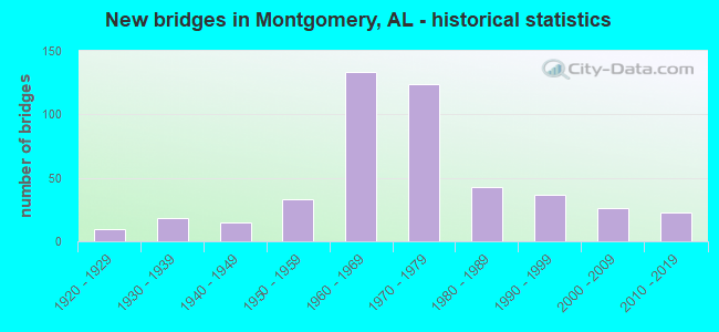
- New bridges - historical statistics
- 11910-1919
- 101920-1929
- 181930-1939
- 151940-1949
- 331950-1959
- 1331960-1969
- 1241970-1979
- 431980-1989
- 371990-1999
- 262000-2009
- 232010-2019
- 12020-2022
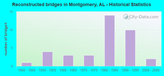
- Reconstructed bridges - Historical Statistics
- 11940-1949
- 41950-1959
- 31960-1969
- 31970-1979
- 141980-1989
- 101990-1999
- 22000-2009
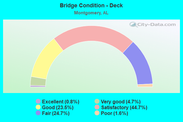
- Bridge Condition - Deck
- 0.8%Excellent
- 4.7%Very good
- 23.5%Good
- 44.7%Satisfactory
- 24.7%Fair
- 1.6%Poor
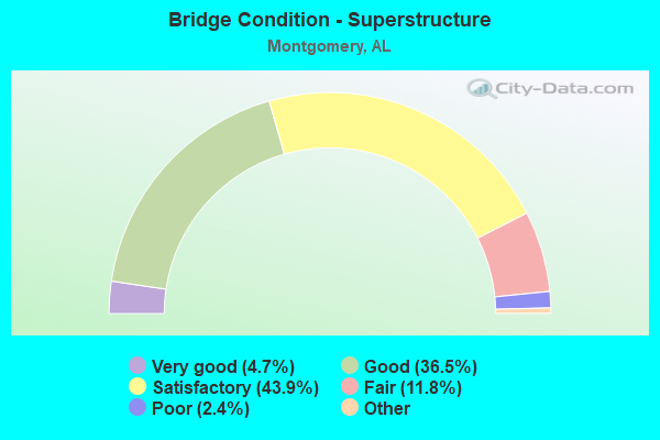
- Bridge Condition - Superstructure
- 4.7%Excellent
- 36.5%Very good
- 43.9%Good
- 11.8%Satisfactory
- 2.4%Fair
- 0.8%Poor
- 0.4%Serious
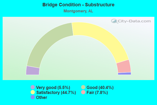
- Bridge Condition - Substructure
- 5.5%Excellent
- 40.4%Very good
- 44.7%Good
- 7.8%Satisfactory
- 1.6%Fair
- 0.8%Poor
- 0.4%Serious
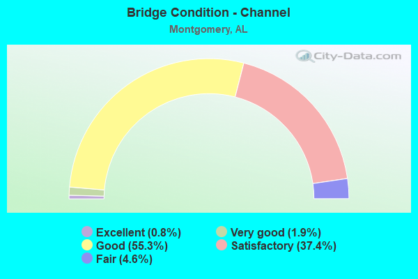
- Bridge Condition - Channel
- 0.8%Excellent
- 1.9%Very good
- 55.3%Good
- 37.4%Satisfactory
- 4.6%Fair
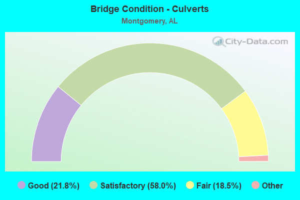
- Bridge Condition - Culverts
- 21.8%Excellent
- 58.0%Very good
- 18.5%Good
- 1.7%Satisfactory
- 18.5%Fair
Find on map >> Show street view
Structure Number: 13605, Location: NW ENTRANCE TO MALL (Lat: 32.388331, Lng: -86.210172), Route carried "on" structure: City street 14, Year Built: 1985, Status: Open, Structure Length: 0.67m (2.20ft), Average Daily Traffic: 4,500 (year 1992), Truck Traffic: 1%, Average Future Daily Traffic: 5,100 (year 2038), Design Load: H 20, Features Intersected: EASTDALE DITCH, Facility Carried by Structure: EASTDALE LOOP
Minimum Vertical Clearance: 30+ m (98+ ft), Kilometerpoint: 0.200, Lanes on structure: 2, Owner: City or Municipal Highway Agency, Approaching Roadway Width: 18.0m (59.1ft), Material/Design: Concrete continuous, Design/Construction: Culvert, Number Of Spans In Main Unit: 2, Length of Maximum Span: 3.0m (9.8ft)
Condition: Channel: Good, Culverts: Good, Operating Rating: 88.9 metric tons, Method Used To Determine Operating Rating: Load Factor (LF), Inventory Rating: 62.5 metric tons, Method Used To Determine Inventory Rating: Load Factor (LF), Structural Evaluation: Better than present minimum criteria, Waterway Adequacy: Better than present minimum criteria, Approach Roadway Alignment: Better than present minimum criteria, Length Of Structure Improvement: 1.30m (4.27ft), Designated Inspection Frequency: Every 24 months, Inspection Date: March 2020, Bridge Improvement Cost: $488,000, Roadway Improvement Cost: $49,000, Total Project Cost: $537,000 ( Estimate for 2022)
Find on map >> Show street view
Structure Number: 13617, Location: 5.0 MI N of Northport (Lat: 33.628783, Lng: -88.073164), Route carried "on" structure: State highway 17, Year Built: 1985, Status: Open, Structure Length: 1.10m (3.61ft), Average Daily Traffic: 1,191 (year 2020), Truck Traffic: 11%, Average Future Daily Traffic: 1,715 (year 2040), Design Load: HS 20, Features Intersected: Mud Creek
Minimum Vertical Clearance: 30+ m (98+ ft), Kilometerpoint: 376.218, Lanes on structure: 2, Base Highway Network: Yes, Owner: State Highway Agency, Approaching Roadway Width: 11.0m (36.1ft), Skew: 3 degrees, Material/Design: Concrete, Design/Construction: Culvert, Number Of Spans In Main Unit: 3, Length of Maximum Span: 3.5m (11.5ft)
Condition: Channel: Good, Culverts: Satisfactory, Operating Rating: 64.6 metric tons, Method Used To Determine Operating Rating: Load Factor (LF), Inventory Rating: 38.7 metric tons, Method Used To Determine Inventory Rating: Load Factor (LF), Structural Evaluation: Equal to present minimum criteria, Waterway Adequacy: Equal to present minimum criteria, Approach Roadway Alignment: Better than present minimum criteria, Length Of Structure Improvement: 1.77m (5.81ft), Designated Inspection Frequency: Every 24 months, Inspection Date: April 2020, Bridge Improvement Cost: $521,000, Roadway Improvement Cost: $52,000, Total Project Cost: $573,000 ( Estimate for 2022)
Find on map >> Show street view
Structure Number: 13663, Location: 0.17 MI E OF MOBILE HWY (Lat: 32.332500, Lng: -86.339800), Route carried "on" structure: City street 58, Year Built: 1985, Status: Open, Structure Length: 1.65m (5.41ft), Average Daily Traffic: 35 (year 1990), Average Future Daily Traffic: 50 (year 2038), Design Load: HS 20, Features Intersected: GENETTA DITCH, Facility Carried by Structure: WHATLEY RD
Minimum Vertical Clearance: 7.56m (24.80ft), Kilometerpoint: 0.150, Lanes on structure: 2, Owner: City or Municipal Highway Agency, Approaching Roadway Width: 7.3m (24.0ft), Skew: 3 degrees, Material/Design: Concrete continuous, Design/Construction: Culvert, Number Of Spans In Main Unit: 5, Length of Maximum Span: 2.4m (7.9ft)
Condition: Channel: Satisfactory, Culverts: Satisfactory, Operating Rating: 51.6 metric tons, Method Used To Determine Operating Rating: Load Factor (LF), Inventory Rating: 30.9 metric tons, Method Used To Determine Inventory Rating: Load Factor (LF), Structural Evaluation: Equal to present minimum criteria, Waterway Adequacy: Equal to present minimum criteria, Approach Roadway Alignment: Better than present minimum criteria, Length Of Structure Improvement: 2.34m (7.68ft), Designated Inspection Frequency: Every 24 months, Inspection Date: March 2020, Bridge Improvement Cost: $324,000, Roadway Improvement Cost: $32,000, Total Project Cost: $356,000 ( Estimate for 2022)
Find on map >> Show street view
Structure Number: 13885, Location: 5.3 MI.S.OF I65 (Lat: 32.210883, Lng: -86.348819), Route carried "on" structure: US 31, Year Built: 1986, Status: Open, Structure Length: 6.25m (20.51ft), Average Daily Traffic: 4,200 (year 2013), Truck Traffic: 9%, Average Future Daily Traffic: 5,395 (year 2033), Design Load: HS 20, Features Intersected: PINTLALA CRK RELIEF
Minimum Vertical Clearance: 30+ m (98+ ft), Kilometerpoint: 271.770, Lanes on structure: 2, Owner: State Highway Agency, Approaching Roadway Width: 12.2m (40.0ft), Material/Design: Prestressed concrete continuous, Design/Construction: Stringer/Multi-beam, Number Of Spans In Main Unit: 5, Length of Maximum Span: 12.5m (41.0ft), Curb-To-Curb Width: 12.2m (40.0ft), Out-to-Out Width: 13.0m (42.7ft)
Condition: Deck: Satisfactory, Superstructure: Satisfactory, Substructure: Satisfactory, Channel: Good, Operating Rating: 50.3 metric tons, Method Used To Determine Operating Rating: Load Factor (LF), Inventory Rating: 30.8 metric tons, Method Used To Determine Inventory Rating: Load Factor (LF), Structural Evaluation: Equal to present minimum criteria, Deck Geometry: Equal to present minimum criteria, Waterway Adequacy: Equal to present desirable criteria, Approach Roadway Alignment: Equal to present minimum criteria, Length Of Structure Improvement: 7.29m (23.92ft), Designated Inspection Frequency: Every 24 months, Inspection Date: October 2021, Bridge Improvement Cost: $2,100,000, Roadway Improvement Cost: $210,000, Total Project Cost: $2,310,000 ( Estimate for 2022), Deck Structure Type: Concrete Cast-file-Place
Find on map >> Show street view
Structure Number: 13886, Location: 4.0 MI.S.OF I65 (Lat: 32.218975, Lng: -86.348814), Route carried "on" structure: US 31, Year Built: 1986, Status: Open, Structure Length: 1.58m (5.18ft), Average Daily Traffic: 4,200 (year 2013), Truck Traffic: 9%, Average Future Daily Traffic: 5,395 (year 2033), Design Load: HS 20, Features Intersected: BEULAH BRANCH
Minimum Vertical Clearance: 30+ m (98+ ft), Kilometerpoint: 273.622, Lanes on structure: 2, Owner: State Highway Agency, Approaching Roadway Width: 12.2m (40.0ft), Material/Design: Concrete continuous, Design/Construction: Culvert, Number Of Spans In Main Unit: 4, Length of Maximum Span: 3.7m (12.1ft), Curb-To-Curb Width: 12.2m (40.0ft), Out-to-Out Width: 13.0m (42.7ft)
Condition: Channel: Satisfactory, Culverts: Satisfactory, Operating Rating: 43.4 metric tons, Method Used To Determine Operating Rating: Load Factor (LF), Inventory Rating: 26.0 metric tons, Method Used To Determine Inventory Rating: Load Factor (LF), Structural Evaluation: Equal to present minimum criteria, Deck Geometry: Equal to present minimum criteria, Waterway Adequacy: Equal to present minimum criteria, Approach Roadway Alignment: Better than present minimum criteria, Length Of Structure Improvement: 2.26m (7.41ft), Designated Inspection Frequency: Every 24 months, Inspection Date: October 2021, Bridge Improvement Cost: $548,000, Roadway Improvement Cost: $55,000, Total Project Cost: $603,000 ( Estimate for 2022)
Find on map >> Show street view
Structure Number: 13887, Location: 0.6 MI.S.OF SOU BLVD (Lat: 32.319281, Lng: -86.349247), Route carried "on" structure: Bypass US 31, Year Built: 1986, Status: Open, Structure Length: 24.63m (80.81ft), Average Daily Traffic: 7,885 (year 2013), Truck Traffic: 9%, Average Future Daily Traffic: 10,129 (year 2033), Design Load: HS 20, Features Intersected: CATOMA CREEK
Minimum Vertical Clearance: 30+ m (98+ ft), Kilometerpoint: 286.114, Lanes on structure: 2, Base Highway Network: Yes, Owner: State Highway Agency, Approaching Roadway Width: 12.2m (40.0ft), Skew: 12 degrees, Material/Design: Prestressed concrete, Design/Construction: Stringer/Multi-beam, Number Of Spans In Main Unit: 1, Number Of Approach Spans: 18, Length of Maximum Span: 21.3m (69.9ft), Curb-To-Curb Width: 12.2m (40.0ft), Out-to-Out Width: 13.0m (42.7ft)
Condition: Deck: Satisfactory, Superstructure: Satisfactory, Substructure: Good, Channel: Satisfactory, Operating Rating: 49.9 metric tons, Method Used To Determine Operating Rating: Load Factor (LF), Inventory Rating: 26.2 metric tons, Method Used To Determine Inventory Rating: Load Factor (LF), Structural Evaluation: Equal to present minimum criteria, Deck Geometry: Better than present minimum criteria, Waterway Adequacy: Equal to present minimum criteria, Approach Roadway Alignment: Better than present minimum criteria, Length Of Structure Improvement: 24.63m (80.81ft), Designated Inspection Frequency: Every 24 months, Inspection Date: March 2021, Bridge Improvement Cost: $7,094,000, Roadway Improvement Cost: $709,000, Total Project Cost: $7,803,000 ( Estimate for 2022), Deck Structure Type: Concrete Cast-file-Place
Find on map >> Show street view
Structure Number: 13895, Location: EASTERN BYPASS AND I85 (Lat: 32.362114, Lng: -86.212172), Route carried "on" structure: Ramp US 80, Year Built: 1986, Status: Open, Structure Length: 6.13m (20.11ft), Average Daily Traffic: 4,686 (year 2011), Truck Traffic: 4%, Average Future Daily Traffic: 7,679 (year 2031), Design Load: HS 20, Features Intersected: I85 NBL, Facility Carried by Structure: AL9 RAMP
Minimum Vertical Clearance: 30+ m (98+ ft), Kilometerpoint: 172.890, Lanes on structure: 1, Lanes under structure: 2, Owner: State Highway Agency, Approaching Roadway Width: 11.3m (37.1ft), Material/Design: Steel continuous, Design/Construction: Stringer/Multi-beam, Number Of Spans In Main Unit: 3, Length of Maximum Span: 29.0m (95.1ft), Curb-To-Curb Width: 8.8m (28.9ft), Out-to-Out Width: 9.7m (31.8ft)
Condition: Deck: Satisfactory, Superstructure: Satisfactory, Substructure: Good, Operating Rating: 82.4 metric tons, Method Used To Determine Operating Rating: Load Factor (LF), Inventory Rating: 49.6 metric tons, Method Used To Determine Inventory Rating: Load Factor (LF), Structural Evaluation: Equal to present minimum criteria, Deck Geometry: Superior to present desirable criteria, Underclear: Equal to present desirable criteria, Approach Roadway Alignment: Better than present minimum criteria, Length Of Structure Improvement: 7.17m (23.52ft), Designated Inspection Frequency: Every 24 months, Inspection Date: January 2022, Bridge Improvement Cost: $1,524,000, Roadway Improvement Cost: $152,000, Total Project Cost: $1,676,000 ( Estimate for 2022), Deck Structure Type: Concrete Cast-file-Place
Find on map >> Show street view
Structure Number: 14082, Location: 200 FT S OF IRIS LN (Lat: 32.329800, Lng: -86.316100), Route carried "on" structure: City street , Year Built: 1948, Year Reconstructed: 1987, Status: Open, Structure Length: 1.46m (4.79ft), Average Daily Traffic: 3,500 (year 1992), Truck Traffic: 1%, Average Future Daily Traffic: 5,100 (year 2038), Design Load: H 15, Features Intersected: CLOVERLAND DITCH, Facility Carried by Structure: ROSA L PARKS AVE
Minimum Vertical Clearance: 30+ m (98+ ft), Kilometerpoint: 0.499, Lanes on structure: 2, Owner: City or Municipal Highway Agency, Approaching Roadway Width: 11.0m (36.1ft), Material/Design: Concrete, Design/Construction: Channel Beam, Number Of Spans In Main Unit: 2, Length of Maximum Span: 7.3m (24.0ft), Curb or Sidewalk Widths: Left: 1.5m (4.9ft), Right: 1.5m (4.9ft), Curb-To-Curb Width: 11.1m (36.4ft), Out-to-Out Width: 15.8m (51.8ft)
Condition: Deck: Satisfactory, Superstructure: Satisfactory, Substructure: Good, Channel: Good, Operating Rating: 60.9 metric tons, Method Used To Determine Operating Rating: Load Factor (LF), Inventory Rating: 36.5 metric tons, Method Used To Determine Inventory Rating: Load Factor (LF), Structural Evaluation: Equal to present minimum criteria, Deck Geometry: Somewhat better than minimum adequacy, Waterway Adequacy: Better than present minimum criteria, Approach Roadway Alignment: Better than present minimum criteria, Length Of Structure Improvement: 2.14m (7.02ft), Designated Inspection Frequency: Every 24 months, Inspection Date: April 2020, Bridge Improvement Cost: $747,000, Roadway Improvement Cost: $75,000, Total Project Cost: $822,000 ( Estimate for 2022), Deck Structure Type: Concrete Precast Panels, Wearing Surface/Protective System: Wearing Surface: Bituminous
Find on map >> Show street view
Structure Number: 14457, Location: 0.3 MI N OF I65 (Lat: 32.367564, Lng: -86.317331), Route carried "on" structure: Interstate 85, Year Built: 1971, Year Reconstructed: 1988, Status: Open, Structure Length: 5.97m (19.59ft), Average Daily Traffic: 94,970 (year 2013), Truck Traffic: 11%, Average Future Daily Traffic: 125,167 (year 2033), Design Load: HS 20, Features Intersected: ROSA PARKS
Minimum Vertical Clearance: 30+ m (98+ ft), Kilometerpoint: 0.497, Lanes on structure: 9, Lanes under structure: 2, Base Highway Network: Yes, Owner: State Highway Agency, Approaching Roadway Width: 43.9m (144.0ft), Skew: 30 degrees, Material/Design: Concrete continuous, Design/Construction: Tee Beam, Number Of Spans In Main Unit: 3, Length of Maximum Span: 22.5m (73.8ft), Curb-To-Curb Width: 45.3m (148.6ft), Out-to-Out Width: 46.9m (153.9ft)
Condition: Deck: Fair, Superstructure: Satisfactory, Substructure: Satisfactory, Operating Rating: 45.6 metric tons, Method Used To Determine Operating Rating: Load Factor (LF), Inventory Rating: 27.3 metric tons, Method Used To Determine Inventory Rating: Load Factor (LF), Structural Evaluation: Equal to present minimum criteria, Deck Geometry: Superior to present desirable criteria, Underclear: Somewhat better than minimum adequacy, Approach Roadway Alignment: Better than present minimum criteria, Length Of Structure Improvement: 7.00m (22.97ft), Designated Inspection Frequency: Every 24 months, Inspection Date: April 2021, Bridge Improvement Cost: $7,397,000, Roadway Improvement Cost: $740,000, Total Project Cost: $8,137,000 ( Estimate for 2022), Deck Structure Type: Concrete Cast-file-Place
Find on map >> Show street view
Structure Number: 14459, Location: 0.6 MI N OF I65 (Lat: 32.367708, Lng: -86.311872), Route carried "on" structure: Interstate 85, Year Built: 1965, Year Reconstructed: 1988, Status: Open, Structure Length: 5.15m (16.90ft), Average Daily Traffic: 94,970 (year 2013), Truck Traffic: 11%, Average Future Daily Traffic: 125,167 (year 2033), Design Load: HS 20, Features Intersected: HOLCOMBE ST
Minimum Vertical Clearance: 30+ m (98+ ft), Kilometerpoint: 0.980, Lanes on structure: 8, Lanes under structure: 2, Base Highway Network: Yes, Owner: State Highway Agency, Approaching Roadway Width: 36.6m (120.1ft), Skew: 30 degrees, Material/Design: Concrete continuous, Design/Construction: Tee Beam, Number Of Spans In Main Unit: 3, Length of Maximum Span: 19.5m (64.0ft), Curb-To-Curb Width: 35.7m (117.1ft), Out-to-Out Width: 36.0m (118.1ft)
Condition: Deck: Fair, Superstructure: Satisfactory, Substructure: Satisfactory, Operating Rating: 49.4 metric tons, Method Used To Determine Operating Rating: Load Factor (LF), Inventory Rating: 29.5 metric tons, Method Used To Determine Inventory Rating: Load Factor (LF), Structural Evaluation: Equal to present minimum criteria, Deck Geometry: Better than present minimum criteria, Underclear: Equal to present minimum criteria, Approach Roadway Alignment: Better than present minimum criteria, Length Of Structure Improvement: 6.17m (20.24ft), Designated Inspection Frequency: Every 24 months, Inspection Date: April 2021, Bridge Improvement Cost: $4,995,000, Roadway Improvement Cost: $500,000, Total Project Cost: $5,495,000 ( Estimate for 2022), Deck Structure Type: Concrete Cast-file-Place
Find on map >> Show street view
Structure Number: 14461, Location: 1.06 MI N OF I65 (Lat: 32.367833, Lng: -86.304594), Route carried "on" structure: Interstate 85, Year Built: 1966, Year Reconstructed: 1988, Status: Open, Structure Length: 5.15m (16.90ft), Average Daily Traffic: 83,530 (year 2013), Truck Traffic: 13%, Average Future Daily Traffic: 110,089 (year 2033), Design Load: HS 20, Features Intersected: MCDONOUGH ST
Minimum Vertical Clearance: 30+ m (98+ ft), Kilometerpoint: 1.672, Lanes on structure: 6, Lanes under structure: 3, Base Highway Network: Yes, Owner: State Highway Agency, Approaching Roadway Width: 36.6m (120.1ft), Skew: 30 degrees, Material/Design: Concrete continuous, Design/Construction: Tee Beam, Number Of Spans In Main Unit: 3, Length of Maximum Span: 19.5m (64.0ft), Curb-To-Curb Width: 32.0m (105.0ft), Out-to-Out Width: 34.5m (113.2ft)
Condition: Deck: Fair, Superstructure: Satisfactory, Substructure: Satisfactory, Operating Rating: 55.0 metric tons, Method Used To Determine Operating Rating: Load Factor (LF), Inventory Rating: 32.7 metric tons, Method Used To Determine Inventory Rating: Load Factor (LF), Structural Evaluation: Equal to present minimum criteria, Deck Geometry: Superior to present desirable criteria, Underclear: Somewhat better than minimum adequacy, Approach Roadway Alignment: Better than present minimum criteria, Length Of Structure Improvement: 6.17m (20.24ft), Designated Inspection Frequency: Every 24 months, Inspection Date: June 2021, Bridge Improvement Cost: $4,784,000, Roadway Improvement Cost: $478,000, Total Project Cost: $5,262,000 ( Estimate for 2022), Deck Structure Type: Concrete Cast-file-Place
Find on map >> Show street view
Structure Number: 14463, Location: 1.11 MI N OF I65 (Lat: 32.367856, Lng: -86.303353), Route carried "on" structure: Interstate 85, Year Built: 1966, Year Reconstructed: 1988, Status: Open, Structure Length: 5.46m (17.91ft), Average Daily Traffic: 83,530 (year 2013), Truck Traffic: 13%, Average Future Daily Traffic: 110,089 (year 2033), Design Load: HS 20, Features Intersected: HULL ST
Minimum Vertical Clearance: 30+ m (98+ ft), Kilometerpoint: 1.801, Lanes on structure: 6, Lanes under structure: 6, Base Highway Network: Yes, Owner: State Highway Agency, Approaching Roadway Width: 36.6m (120.1ft), Skew: 30 degrees, Material/Design: Concrete continuous, Design/Construction: Tee Beam, Number Of Spans In Main Unit: 3, Length of Maximum Span: 20.7m (67.9ft), Curb-To-Curb Width: 32.0m (105.0ft), Out-to-Out Width: 33.8m (110.9ft)
Condition: Deck: Fair, Superstructure: Satisfactory, Substructure: Satisfactory, Operating Rating: 64.9 metric tons, Method Used To Determine Operating Rating: Load Factor (LF), Inventory Rating: 39.0 metric tons, Method Used To Determine Inventory Rating: Load Factor (LF), Structural Evaluation: Equal to present minimum criteria, Deck Geometry: Superior to present desirable criteria, Underclear: Equal to present minimum criteria, Approach Roadway Alignment: Better than present minimum criteria, Length Of Structure Improvement: 6.49m (21.29ft), Designated Inspection Frequency: Every 24 months, Inspection Date: April 2021, Bridge Improvement Cost: $4,895,000, Roadway Improvement Cost: $490,000, Total Project Cost: $5,385,000 ( Estimate for 2022), Deck Structure Type: Concrete Cast-file-Place
Find on map >> Show street view
Structure Number: 14465, Location: 1.18 MI N OF I65 (Lat: 32.367878, Lng: -86.302100), Route carried "on" structure: Interstate 85, Year Built: 1966, Year Reconstructed: 1988, Status: Open, Structure Length: 5.46m (17.91ft), Average Daily Traffic: 83,530 (year 2013), Truck Traffic: 13%, Average Future Daily Traffic: 110,089 (year 2033), Design Load: HS 20, Features Intersected: DECATUR ST
Minimum Vertical Clearance: 30+ m (98+ ft), Kilometerpoint: 1.897, Lanes on structure: 6, Lanes under structure: 4, Base Highway Network: Yes, Owner: State Highway Agency, Approaching Roadway Width: 36.6m (120.1ft), Skew: 30 degrees, Material/Design: Concrete continuous, Design/Construction: Tee Beam, Number Of Spans In Main Unit: 3, Length of Maximum Span: 20.7m (67.9ft), Curb-To-Curb Width: 32.0m (105.0ft), Out-to-Out Width: 33.8m (110.9ft)
Condition: Deck: Satisfactory, Superstructure: Good, Substructure: Good, Operating Rating: 64.9 metric tons, Method Used To Determine Operating Rating: Load Factor (LF), Inventory Rating: 39.0 metric tons, Method Used To Determine Inventory Rating: Load Factor (LF), Structural Evaluation: Better than present minimum criteria, Deck Geometry: Superior to present desirable criteria, Underclear: Somewhat better than minimum adequacy, Approach Roadway Alignment: Better than present minimum criteria, Length Of Structure Improvement: 6.49m (21.29ft), Designated Inspection Frequency: Every 24 months, Inspection Date: April 2021, Bridge Improvement Cost: $4,895,000, Roadway Improvement Cost: $490,000, Total Project Cost: $5,385,000 ( Estimate for 2022), Deck Structure Type: Concrete Cast-file-Place
Find on map >> Show street view
Structure Number: 14469, Location: 1.5 MI N OF I65 (Lat: 32.367986, Lng: -86.296261), Route carried "on" structure: Interstate 85, Year Built: 1969, Year Reconstructed: 1988, Status: Open, Structure Length: 5.15m (16.90ft), Average Daily Traffic: 104,310 (year 2013), Truck Traffic: 10%, Average Future Daily Traffic: 137,476 (year 2033), Design Load: HS 20, Features Intersected: S JACKSON ST
Minimum Vertical Clearance: 30+ m (98+ ft), Kilometerpoint: 2.445, Lanes on structure: 10, Lanes under structure: 2, Base Highway Network: Yes, Owner: State Highway Agency, Approaching Roadway Width: 44.8m (147.0ft), Skew: 30 degrees, Material/Design: Concrete continuous, Design/Construction: Tee Beam, Number Of Spans In Main Unit: 3, Length of Maximum Span: 19.5m (64.0ft), Curb-To-Curb Width: 46.6m (152.9ft), Out-to-Out Width: 48.6m (159.4ft)
Condition: Deck: Fair, Superstructure: Fair, Substructure: Satisfactory, Operating Rating: 51.2 metric tons, Method Used To Determine Operating Rating: Load Factor (LF), Inventory Rating: 30.5 metric tons, Method Used To Determine Inventory Rating: Load Factor (LF), Structural Evaluation: Somewhat better than minimum adequacy, Deck Geometry: Superior to present desirable criteria, Underclear: Somewhat better than minimum adequacy, Approach Roadway Alignment: Better than present minimum criteria, Length Of Structure Improvement: 6.17m (20.24ft), Designated Inspection Frequency: Every 24 months, Inspection Date: May 2021, Bridge Improvement Cost: $6,731,000, Roadway Improvement Cost: $673,000, Total Project Cost: $7,404,000 ( Estimate for 2022), Deck Structure Type: Concrete Cast-file-Place
Find on map >> Show street view
Structure Number: 14659, Location: 1.6 MI N OF US 110 (Lat: 32.361900, Lng: -86.133500), Route carried "on" structure: County highway 234, Year Built: 1988, Status: Open, Structure Length: 4.15m (13.62ft), Average Daily Traffic: 1,500 (year 1988), Truck Traffic: 1%, Average Future Daily Traffic: 2,500 (year 2040), Design Load: HS 20, Features Intersected: CREEK, Facility Carried by Structure: RYAN ROAD
Minimum Vertical Clearance: 30+ m (98+ ft), Kilometerpoint: 0.010, Lanes on structure: 2, Owner: County Highway Agency, Approaching Roadway Width: 11.0m (36.1ft), Material/Design: Concrete, Design/Construction: Channel Beam, Number Of Spans In Main Unit: 4, Length of Maximum Span: 10.4m (34.1ft), Curb-To-Curb Width: 8.6m (28.2ft), Out-to-Out Width: 9.4m (30.8ft)
Condition: Deck: Very good, Superstructure: Very good, Substructure: Good, Channel: Good, Operating Rating: 60.1 metric tons, Method Used To Determine Operating Rating: Load Factor (LF), Inventory Rating: 36.0 metric tons, Method Used To Determine Inventory Rating: Load Factor (LF), Structural Evaluation: Better than present minimum criteria, Deck Geometry: Somewhat better than minimum adequacy, Waterway Adequacy: Better than present minimum criteria, Approach Roadway Alignment: Better than present minimum criteria, Length Of Structure Improvement: 5.12m (16.80ft), Designated Inspection Frequency: Every 24 months, Inspection Date: December 2020, Bridge Improvement Cost: $1,053,000, Roadway Improvement Cost: $105,000, Total Project Cost: $1,158,000 ( Estimate for 2022), Deck Structure Type: Concrete Precast Panels
Find on map >> Show street view
Structure Number: 15396, Location: .9 OF A MI. WEST OFUS 80 (Lat: 32.285128, Lng: -86.445700), Route carried "on" structure: County highway , Year Built: 1991, Status: Open, Structure Length: 1.46m (4.79ft), Average Daily Traffic: 90 (year 1988), Average Future Daily Traffic: 125 (year 2040), Design Load: HS 20, Features Intersected: CREEK, Facility Carried by Structure: TALLANT ROAD
Minimum Vertical Clearance: 30+ m (98+ ft), Kilometerpoint: 0.000, Lanes on structure: 2, Owner: County Highway Agency, Approaching Roadway Width: 11.0m (36.1ft), Material/Design: Concrete, Design/Construction: Channel Beam, Number Of Spans In Main Unit: 2, Length of Maximum Span: 7.3m (24.0ft), Curb-To-Curb Width: 8.9m (29.2ft), Out-to-Out Width: 9.4m (30.8ft)
Condition: Deck: Good, Superstructure: Good, Substructure: Good, Channel: Satisfactory, Operating Rating: 71.5 metric tons, Method Used To Determine Operating Rating: Load Factor (LF), Inventory Rating: 42.8 metric tons, Method Used To Determine Inventory Rating: Load Factor (LF), Structural Evaluation: Better than present minimum criteria, Deck Geometry: Better than present minimum criteria, Waterway Adequacy: Better than present minimum criteria, Approach Roadway Alignment: Equal to present minimum criteria, Length Of Structure Improvement: 2.14m (7.02ft), Designated Inspection Frequency: Every 24 months, Inspection Date: May 2020, Bridge Improvement Cost: $440,000, Roadway Improvement Cost: $44,000, Total Project Cost: $484,000 ( Estimate for 2022), Deck Structure Type: Concrete Precast Panels
Find on map >> Show street view
Structure Number: 15398, Location: .9 MI E OF LOWERWETUMPKA (Lat: 32.441953, Lng: -86.252008), Route carried "on" structure: County highway , Year Built: 1992, Status: Open, Structure Length: 1.46m (4.79ft), Average Daily Traffic: 86 (year 1988), Average Future Daily Traffic: 125 (year 2040), Design Load: HS 20, Features Intersected: GALBRAITH MILL CREEK, Facility Carried by Structure: STOKES ROAD
Minimum Vertical Clearance: 30+ m (98+ ft), Kilometerpoint: 0.010, Lanes on structure: 2, Owner: County Highway Agency, Approaching Roadway Width: 11.0m (36.1ft), Material/Design: Concrete, Design/Construction: Channel Beam, Number Of Spans In Main Unit: 2, Length of Maximum Span: 7.3m (24.0ft), Curb-To-Curb Width: 8.6m (28.2ft), Out-to-Out Width: 9.4m (30.8ft)
Condition: Deck: Very good, Superstructure: Good, Substructure: Good, Channel: Satisfactory, Operating Rating: 53.5 metric tons, Method Used To Determine Operating Rating: Load Factor (LF), Inventory Rating: 32.1 metric tons, Method Used To Determine Inventory Rating: Load Factor (LF), Structural Evaluation: Better than present minimum criteria, Deck Geometry: Better than present minimum criteria, Waterway Adequacy: Better than present minimum criteria, Approach Roadway Alignment: Better than present minimum criteria, Length Of Structure Improvement: 2.14m (7.02ft), Designated Inspection Frequency: Every 24 months, Inspection Date: May 2020, Bridge Improvement Cost: $440,000, Roadway Improvement Cost: $44,000, Total Project Cost: $484,000 ( Estimate for 2022), Deck Structure Type: Concrete Precast Panels
Find on map >> Show street view
Structure Number: 154, Location: .7 MI N FORBES RD (Lat: 32.421556, Lng: -86.303467), Route carried "on" structure: County highway , Year Built: 1991, Status: Open, Structure Length: 4.15m (13.62ft), Average Daily Traffic: 52 (year 1988), Average Future Daily Traffic: 100 (year 2040), Design Load: HS 20, Features Intersected: CONNELLY MILL CREEK, Facility Carried by Structure: JACKSON FERRY RD.
Minimum Vertical Clearance: 30+ m (98+ ft), Kilometerpoint: 0.000, Lanes on structure: 2, Owner: County Highway Agency, Approaching Roadway Width: 11.0m (36.1ft), Material/Design: Concrete, Design/Construction: Channel Beam, Number Of Spans In Main Unit: 4, Length of Maximum Span: 10.4m (34.1ft), Curb-To-Curb Width: 8.6m (28.2ft), Out-to-Out Width: 9.4m (30.8ft)
Condition: Deck: Good, Superstructure: Good, Substructure: Good, Channel: Satisfactory, Operating Rating: 58.9 metric tons, Method Used To Determine Operating Rating: Load Factor (LF), Inventory Rating: 35.3 metric tons, Method Used To Determine Inventory Rating: Load Factor (LF), Structural Evaluation: Better than present minimum criteria, Deck Geometry: Better than present minimum criteria, Waterway Adequacy: Better than present minimum criteria, Approach Roadway Alignment: Better than present minimum criteria, Length Of Structure Improvement: 5.12m (16.80ft), Designated Inspection Frequency: Every 24 months, Inspection Date: May 2020, Bridge Improvement Cost: $1,053,000, Roadway Improvement Cost: $105,000, Total Project Cost: $1,158,000 ( Estimate for 2022), Deck Structure Type: Concrete Precast Panels
Find on map >> Show street view
Structure Number: 15401, Location: .9 MI S FOURSPOTS ROAD (Lat: 32.411544, Lng: -86.262528), Route carried "on" structure: County highway , Year Built: 1991, Status: Open, Structure Length: 2.19m (7.19ft), Average Daily Traffic: 48 (year 1988), Average Future Daily Traffic: 60 (year 2040), Design Load: HS 20, Features Intersected: GALBRAITH MILL CREEK, Facility Carried by Structure: LOUIS PREISTER RD.
Minimum Vertical Clearance: 30+ m (98+ ft), Kilometerpoint: 0.010, Lanes on structure: 2, Owner: County Highway Agency, Approaching Roadway Width: 11.0m (36.1ft), Material/Design: Concrete, Design/Construction: Channel Beam, Number Of Spans In Main Unit: 3, Length of Maximum Span: 7.3m (24.0ft), Curb-To-Curb Width: 8.6m (28.2ft), Out-to-Out Width: 9.4m (30.8ft)
Condition: Deck: Good, Superstructure: Good, Substructure: Good, Channel: Good, Operating Rating: 58.9 metric tons, Method Used To Determine Operating Rating: Load Factor (LF), Inventory Rating: 35.3 metric tons, Method Used To Determine Inventory Rating: Load Factor (LF), Structural Evaluation: Better than present minimum criteria, Deck Geometry: Better than present minimum criteria, Waterway Adequacy: Better than present minimum criteria, Approach Roadway Alignment: Equal to present minimum criteria, Length Of Structure Improvement: 2.99m (9.81ft), Designated Inspection Frequency: Every 24 months, Inspection Date: June 2020, Bridge Improvement Cost: $615,000, Roadway Improvement Cost: $62,000, Total Project Cost: $677,000 ( Estimate for 2022), Deck Structure Type: Concrete Precast Panels
Find on map >> Show street view
Structure Number: 15438, Location: 2.1 MI E OF MONTG LOWNDES (Lat: 32.350978, Lng: -86.444456), Route carried "on" structure: County highway 18, Year Built: 1991, Status: Open, Structure Length: 2.07m (6.79ft), Average Daily Traffic: 1,000 (year 1991), Truck Traffic: 1%, Average Future Daily Traffic: 2,500 (year 2040), Design Load: HS 20, Features Intersected: STONES SLOUGH, Facility Carried by Structure: OLD SELMA ROAD
Minimum Vertical Clearance: 30+ m (98+ ft), Kilometerpoint: 0.010, Lanes on structure: 2, Owner: County Highway Agency, Approaching Roadway Width: 11.0m (36.1ft), Material/Design: Concrete, Design/Construction: Channel Beam, Number Of Spans In Main Unit: 2, Length of Maximum Span: 10.4m (34.1ft), Curb-To-Curb Width: 8.9m (29.2ft), Out-to-Out Width: 9.4m (30.8ft)
Condition: Deck: Very good, Superstructure: Good, Substructure: Good, Channel: Satisfactory, Operating Rating: 53.5 metric tons, Method Used To Determine Operating Rating: Load Factor (LF), Inventory Rating: 32.1 metric tons, Method Used To Determine Inventory Rating: Load Factor (LF), Structural Evaluation: Better than present minimum criteria, Deck Geometry: Somewhat better than minimum adequacy, Waterway Adequacy: Better than present minimum criteria, Approach Roadway Alignment: Better than present minimum criteria, Length Of Structure Improvement: 2.84m (9.32ft), Designated Inspection Frequency: Every 24 months, Inspection Date: May 2020, Bridge Improvement Cost: $584,000, Roadway Improvement Cost: $58,000, Total Project Cost: $642,000 ( Estimate for 2022), Deck Structure Type: Concrete Precast Panels
Find on map >> Show street view
Structure Number: 15471, Location: 200FT E OF FOREST PARK DR (Lat: 32.377600, Lng: -86.264400), Route carried "on" structure: City street , Year Built: 1991, Status: Open, Structure Length: 2.07m (6.79ft), Average Daily Traffic: 150 (year 1991), Truck Traffic: 1%, Average Future Daily Traffic: 404 (year 2038), Design Load: HS 20, Features Intersected: THREE MILE BRANCH, Facility Carried by Structure: GREEN PINE LN
Minimum Vertical Clearance: 7.56m (24.80ft), Kilometerpoint: 0.100, Lanes on structure: 2, Owner: City or Municipal Highway Agency, Approaching Roadway Width: 8.5m (27.9ft), Material/Design: Concrete, Design/Construction: Channel Beam, Number Of Spans In Main Unit: 2, Length of Maximum Span: 10.4m (34.1ft), Curb or Sidewalk Widths: Left: 1.8m (5.9ft), Right: 0.0m, Curb-To-Curb Width: 7.3m (24.0ft), Out-to-Out Width: 10.0m (32.8ft)
Condition: Deck: Good, Superstructure: Good, Substructure: Good, Channel: Good, Operating Rating: 51.5 metric tons, Method Used To Determine Operating Rating: Load Factor (LF), Inventory Rating: 30.8 metric tons, Method Used To Determine Inventory Rating: Load Factor (LF), Structural Evaluation: Better than present minimum criteria, Deck Geometry: Somewhat better than minimum adequacy, Waterway Adequacy: Better than present minimum criteria, Approach Roadway Alignment: Better than present minimum criteria, Length Of Structure Improvement: 2.84m (9.32ft), Designated Inspection Frequency: Every 24 months, Inspection Date: March 2020, Bridge Improvement Cost: $623,000, Roadway Improvement Cost: $62,000, Total Project Cost: $685,000 ( Estimate for 2022), Deck Structure Type: Concrete Precast Panels
Find on map >> Show street view
Structure Number: 15506, Location: 1.4 MI.S.OF SOU.BLVD. (Lat: 32.315383, Lng: -86.336869), Route carried "on" structure: Interstate 65, Year Built: 1966, Year Reconstructed: 1992, Status: Open, Structure Length: 30.21m (99.11ft), Average Daily Traffic: 32,555 (year 2013), Truck Traffic: 16%, Average Future Daily Traffic: 41,245 (year 2033), Design Load: HS 20, Features Intersected: CATOMA CREEK
Minimum Vertical Clearance: 30+ m (98+ ft), Kilometerpoint: 269.370, Lanes on structure: 4, Base Highway Network: Yes, Owner: State Highway Agency, Approaching Roadway Width: 20.7m (67.9ft), Skew: 13 degrees, Material/Design: Concrete continuous, Design/Construction: Tee Beam, Number Of Spans In Main Unit: 3, Number Of Approach Spans: 23, Length of Maximum Span: 24.4m (80.1ft), Curb-To-Curb Width: 20.7m (67.9ft), Out-to-Out Width: 21.6m (70.9ft)
Condition: Deck: Fair, Superstructure: Satisfactory, Substructure: Fair, Channel: Satisfactory, Operating Rating: 41.5 metric tons, Method Used To Determine Operating Rating: Load Factor (LF), Inventory Rating: 24.9 metric tons, Method Used To Determine Inventory Rating: Load Factor (LF), Structural Evaluation: Somewhat better than minimum adequacy, Deck Geometry: Equal to present minimum criteria, Waterway Adequacy: Better than present minimum criteria, Approach Roadway Alignment: Better than present minimum criteria, Length Of Structure Improvement: 30.21m (99.11ft), Designated Inspection Frequency: Every 24 months, Inspection Date: April 2021, Bridge Improvement Cost: $14,500,000, Roadway Improvement Cost: $1,450,000, Total Project Cost: $15,950,000 ( Estimate for 2022), Deck Structure Type: Concrete Cast-file-Place
Find on map >> Show street view
Structure Number: 15507, Location: 1.4 MI.S.OF SOU.BLVD. (Lat: 32.315250, Lng: -86.336519), Route carried "on" structure: Interstate 65, Year Built: 1966, Year Reconstructed: 1992, Status: Open, Structure Length: 30.21m (99.11ft), Average Daily Traffic: 32,555 (year 2013), Truck Traffic: 16%, Average Future Daily Traffic: 41,245 (year 2033), Design Load: HS 20, Features Intersected: CATOMA CREEK
Minimum Vertical Clearance: 30+ m (98+ ft), Kilometerpoint: 269.370, Lanes on structure: 4, Base Highway Network: Yes, Owner: State Highway Agency, Approaching Roadway Width: 20.7m (67.9ft), Skew: 13 degrees, Material/Design: Concrete continuous, Design/Construction: Tee Beam, Number Of Spans In Main Unit: 3, Number Of Approach Spans: 23, Length of Maximum Span: 24.4m (80.1ft), Curb-To-Curb Width: 20.7m (67.9ft), Out-to-Out Width: 21.6m (70.9ft)
Condition: Deck: Fair, Superstructure: Satisfactory, Substructure: Fair, Channel: Satisfactory, Operating Rating: 41.5 metric tons, Method Used To Determine Operating Rating: Load Factor (LF), Inventory Rating: 24.9 metric tons, Method Used To Determine Inventory Rating: Load Factor (LF), Structural Evaluation: Somewhat better than minimum adequacy, Deck Geometry: Equal to present minimum criteria, Waterway Adequacy: Better than present minimum criteria, Approach Roadway Alignment: Better than present minimum criteria, Length Of Structure Improvement: 30.21m (99.11ft), Designated Inspection Frequency: Every 24 months, Inspection Date: April 2021, Bridge Improvement Cost: $14,500,000, Roadway Improvement Cost: $1,450,000, Total Project Cost: $15,950,000 ( Estimate for 2022), Deck Structure Type: Concrete Cast-file-Place
Find on map >> Show street view
Structure Number: 1553, Location: 0.4 MI.W.OF JCT.US 31 (Lat: 32.311667, Lng: -86.356667), Route carried "on" structure: US 80, Year Built: 1992, Status: Open, Structure Length: 4.21m (13.81ft), Average Daily Traffic: 12,126 (year 2013), Truck Traffic: 9%, Average Future Daily Traffic: 15,856 (year 2033), Design Load: HS 20, Features Intersected: L*N RR
Minimum Vertical Clearance: 30+ m (98+ ft), Kilometerpoint: 206.743, Lanes on structure: 3, Base Highway Network: Yes, Owner: State Highway Agency, Approaching Roadway Width: 15.8m (51.8ft), Skew: 16 degrees, Material/Design: Prestressed concrete, Design/Construction: Stringer/Multi-beam, Number Of Spans In Main Unit: 3, Length of Maximum Span: 18.9m (62.0ft), Curb-To-Curb Width: 15.8m (51.8ft), Out-to-Out Width: 16.7m (54.8ft)
Condition: Deck: Satisfactory, Superstructure: Good, Substructure: Good, Operating Rating: 56.8 metric tons, Method Used To Determine Operating Rating: Load Factor (LF), Inventory Rating: 34.0 metric tons, Method Used To Determine Inventory Rating: Load Factor (LF), Structural Evaluation: Better than present minimum criteria, Deck Geometry: Somewhat better than minimum adequacy, Underclear: Better than present minimum criteria, Approach Roadway Alignment: Better than present minimum criteria, Length Of Structure Improvement: 5.18m (16.99ft), Designated Inspection Frequency: Every 24 months, Inspection Date: January 2022, Bridge Improvement Cost: $1,918,000, Roadway Improvement Cost: $192,000, Total Project Cost: $2,110,000 ( Estimate for 2022), Deck Structure Type: Concrete Cast-file-Place
Find on map >> Show street view
Structure Number: 15531, Location: 0.4 MI.W.JCT OF US 31 (Lat: 32.311667, Lng: -86.356667), Route carried "on" structure: US 80, Year Built: 1992, Status: Open, Structure Length: 4.21m (13.81ft), Average Daily Traffic: 12,126 (year 2013), Truck Traffic: 9%, Average Future Daily Traffic: 15,856 (year 2033), Design Load: HS 20, Features Intersected: L*N RR
Minimum Vertical Clearance: 30+ m (98+ ft), Kilometerpoint: 206.743, Lanes on structure: 3, Base Highway Network: Yes, Owner: State Highway Agency, Approaching Roadway Width: 15.8m (51.8ft), Skew: 16 degrees, Material/Design: Prestressed concrete, Design/Construction: Stringer/Multi-beam, Number Of Spans In Main Unit: 3, Length of Maximum Span: 18.9m (62.0ft), Curb-To-Curb Width: 15.8m (51.8ft), Out-to-Out Width: 16.7m (54.8ft)
Condition: Deck: Satisfactory, Superstructure: Good, Substructure: Satisfactory, Operating Rating: 55.0 metric tons, Method Used To Determine Operating Rating: Load Factor (LF), Inventory Rating: 34.2 metric tons, Method Used To Determine Inventory Rating: Load Factor (LF), Structural Evaluation: Equal to present minimum criteria, Deck Geometry: Somewhat better than minimum adequacy, Underclear: Better than present minimum criteria, Approach Roadway Alignment: Better than present minimum criteria, Length Of Structure Improvement: 5.18m (16.99ft), Designated Inspection Frequency: Every 24 months, Inspection Date: January 2022, Bridge Improvement Cost: $1,918,000, Roadway Improvement Cost: $192,000, Total Project Cost: $2,110,000 ( Estimate for 2022), Deck Structure Type: Concrete Cast-file-Place
Find on map >> Show street view
Structure Number: 15532, Location: US 80 * US 31 INT. (Lat: 32.311817, Lng: -86.350217), Route carried "on" structure: US 80, Year Built: 1992, Status: Open, Structure Length: 7.25m (23.79ft), Average Daily Traffic: 16,685 (year 2013), Truck Traffic: 10%, Average Future Daily Traffic: 21,817 (year 2033), Design Load: HS 20, Features Intersected: US 31
Minimum Vertical Clearance: 30+ m (98+ ft), Kilometerpoint: 207.303, Lanes on structure: 2, Lanes under structure: 6, Base Highway Network: Yes, Owner: State Highway Agency, Approaching Roadway Width: 12.2m (40.0ft), Skew: 10 degrees, Material/Design: Prestressed concrete, Design/Construction: Stringer/Multi-beam, Number Of Spans In Main Unit: 3, Length of Maximum Span: 42.1m (138.1ft), Curb-To-Curb Width: 12.2m (40.0ft), Out-to-Out Width: 13.0m (42.7ft)
Condition: Deck: Good, Superstructure: Good, Substructure: Good, Operating Rating: 72.4 metric tons, Method Used To Determine Operating Rating: Load Factor (LF), Inventory Rating: 36.8 metric tons, Method Used To Determine Inventory Rating: Load Factor (LF), Structural Evaluation: Better than present minimum criteria, Deck Geometry: Better than present minimum criteria, Underclear: Equal to present desirable criteria, Approach Roadway Alignment: Better than present minimum criteria, Length Of Structure Improvement: 8.28m (27.17ft), Designated Inspection Frequency: Every 24 months, Inspection Date: January 2022, Bridge Improvement Cost: $2,384,000, Roadway Improvement Cost: $238,000, Total Project Cost: $2,622,000 ( Estimate for 2022), Deck Structure Type: Concrete Cast-file-Place
Find on map >> Show street view
Structure Number: 15533, Location: US 80 * US 31 INT (Lat: 32.311817, Lng: -86.350217), Route carried "on" structure: US 80, Year Built: 1992, Status: Open, Structure Length: 7.25m (23.79ft), Average Daily Traffic: 16,685 (year 2013), Truck Traffic: 10%, Average Future Daily Traffic: 21,817 (year 2033), Design Load: HS 20, Features Intersected: US 31
Minimum Vertical Clearance: 30+ m (98+ ft), Kilometerpoint: 207.303, Lanes on structure: 2, Lanes under structure: 6, Base Highway Network: Yes, Owner: State Highway Agency, Approaching Roadway Width: 12.2m (40.0ft), Skew: 10 degrees, Material/Design: Prestressed concrete, Design/Construction: Stringer/Multi-beam, Number Of Spans In Main Unit: 3, Length of Maximum Span: 42.1m (138.1ft), Curb-To-Curb Width: 12.2m (40.0ft), Out-to-Out Width: 13.0m (42.7ft)
Condition: Deck: Good, Superstructure: Good, Substructure: Good, Operating Rating: 72.6 metric tons, Method Used To Determine Operating Rating: Load Factor (LF), Inventory Rating: 34.5 metric tons, Method Used To Determine Inventory Rating: Load Factor (LF), Structural Evaluation: Better than present minimum criteria, Deck Geometry: Better than present minimum criteria, Underclear: Equal to present desirable criteria, Approach Roadway Alignment: Better than present minimum criteria, Length Of Structure Improvement: 8.28m (27.17ft), Designated Inspection Frequency: Every 24 months, Inspection Date: January 2022, Bridge Improvement Cost: $2,384,000, Roadway Improvement Cost: $238,000, Total Project Cost: $2,622,000 ( Estimate for 2022), Deck Structure Type: Concrete Cast-file-Place
Find on map >> Show street view
Structure Number: 15534, Location: 0.1 MI. W. JCT. US 31 (Lat: 32.311817, Lng: -86.350217), Route carried "on" structure: US 80, Year Built: 1992, Status: Open, Structure Length: 0.94m (3.08ft), Average Daily Traffic: 33,370 (year 2013), Truck Traffic: 10%, Average Future Daily Traffic: 43,635 (year 2033), Design Load: HS 20, Features Intersected: STREAM
Minimum Vertical Clearance: 30+ m (98+ ft), Kilometerpoint: 207.303, Lanes on structure: 13, Base Highway Network: Yes, Owner: State Highway Agency, Approaching Roadway Width: 15.8m (51.8ft), Skew: 17 degrees, Material/Design: Concrete continuous, Design/Construction: Culvert, Number Of Spans In Main Unit: 1, Length of Maximum Span: 9.4m (30.8ft)
Condition: Channel: Good, Culverts: Satisfactory, Operating Rating: 48.2 metric tons, Method Used To Determine Operating Rating: Load Factor (LF), Inventory Rating: 28.8 metric tons, Method Used To Determine Inventory Rating: Load Factor (LF), Structural Evaluation: Equal to present minimum criteria, Waterway Adequacy: Superior to present desirable criteria, Approach Roadway Alignment: Better than present minimum criteria, Length Of Structure Improvement: 1.61m (5.28ft), Designated Inspection Frequency: Every 24 months, Inspection Date: January 2022, Bridge Improvement Cost: $8,812,000, Roadway Improvement Cost: $881,000, Total Project Cost: $9,693,000 ( Estimate for 2022)
Find on map >> Show street view
Structure Number: 15535, Location: 0.7 MI E OF JCT OF US 31 (Lat: 32.309933, Lng: -86.333750), Route carried "on" structure: Ramp US 80, Year Built: 1992, Status: Open, Structure Length: 9.45m (31.00ft), Average Daily Traffic: 14,930 (year 2000), Truck Traffic: 10%, Average Future Daily Traffic: 28,529 (year 2030), Design Load: HS 20, Features Intersected: I65
Minimum Vertical Clearance: 30+ m (98+ ft), Kilometerpoint: 208.626, Lanes on structure: 2, Lanes under structure: 4, Base Highway Network: Yes, Owner: State Highway Agency, Approaching Roadway Width: 11.6m (38.1ft), Skew: 10 degrees, Material/Design: Steel continuous, Design/Construction: Stringer/Multi-beam, Number Of Spans In Main Unit: 4, Length of Maximum Span: 27.4m (89.9ft), Curb-To-Curb Width: 11.6m (38.1ft), Out-to-Out Width: 12.5m (41.0ft)
Condition: Deck: Satisfactory, Superstructure: Satisfactory, Substructure: Good, Operating Rating: 74.9 metric tons, Method Used To Determine Operating Rating: Load Factor (LF), Inventory Rating: 44.9 metric tons, Method Used To Determine Inventory Rating: Load Factor (LF), Structural Evaluation: Equal to present minimum criteria, Deck Geometry: Superior to present desirable criteria, Underclear: Better than present minimum criteria, Approach Roadway Alignment: Better than present minimum criteria, Length Of Structure Improvement: 10.40m (34.12ft), Designated Inspection Frequency: Every 24 months, Inspection Date: January 2022, Bridge Improvement Cost: $2,924,000, Roadway Improvement Cost: $292,000, Total Project Cost: $3,216,000 ( Estimate for 2022), Deck Structure Type: Concrete Cast-file-Place
Find on map >> Show street view
Structure Number: 15536, Location: 0.7 MI E OF JCT OF US 31 (Lat: 32.310700, Lng: -86.335300), Route carried "on" structure: Ramp US 80, Year Built: 1992, Status: Open, Structure Length: 8.84m (29.00ft), Average Daily Traffic: 14,120 (year 1999), Truck Traffic: 16%, Average Future Daily Traffic: 26,466 (year 2030), Design Load: HS 20, Features Intersected: US 80 WBL (RAMP)
Minimum Vertical Clearance: 30+ m (98+ ft), Kilometerpoint: 208.837, Lanes on structure: 2, Lanes under structure: 4, Base Highway Network: Yes, Owner: State Highway Agency, Approaching Roadway Width: 12.2m (40.0ft), Skew: 10 degrees, Material/Design: Steel continuous, Design/Construction: Stringer/Multi-beam, Number Of Spans In Main Unit: 4, Length of Maximum Span: 25.9m (85.0ft), Curb-To-Curb Width: 11.6m (38.1ft), Out-to-Out Width: 12.5m (41.0ft)
Condition: Deck: Satisfactory, Superstructure: Satisfactory, Substructure: Good, Operating Rating: 75.9 metric tons, Method Used To Determine Operating Rating: Load Factor (LF), Inventory Rating: 45.4 metric tons, Method Used To Determine Inventory Rating: Load Factor (LF), Structural Evaluation: Equal to present minimum criteria, Deck Geometry: Superior to present desirable criteria, Underclear: High priority of corrective action, Approach Roadway Alignment: Better than present minimum criteria, Length Of Structure Improvement: 9.82m (32.22ft), Designated Inspection Frequency: Every 24 months, Inspection Date: Febuary 2022, Bridge Improvement Cost: $2,760,000, Roadway Improvement Cost: $276,000, Total Project Cost: $3,036,000 ( Estimate for 2022), Deck Structure Type: Concrete Cast-file-Place
Find on map >> Show street view
Structure Number: 15537, Location: 0.7 MI E OF JCT OF US 31 (Lat: 32.310700, Lng: -86.335300), Route carried "on" structure: US 80, Year Built: 1992, Status: Open, Structure Length: 8.60m (28.22ft), Average Daily Traffic: 10,285 (year 1999), Truck Traffic: 11%, Average Future Daily Traffic: 19,657 (year 2030), Design Load: HS 20, Features Intersected: I-65
Minimum Vertical Clearance: 30+ m (98+ ft), Kilometerpoint: 208.626, Lanes on structure: 2, Lanes under structure: 4, Base Highway Network: Yes, Owner: State Highway Agency, Approaching Roadway Width: 15.8m (51.8ft), Skew: 11 degrees, Material/Design: Steel continuous, Design/Construction: Stringer/Multi-beam, Number Of Spans In Main Unit: 2, Number Of Approach Spans: 2, Length of Maximum Span: 27.7m (90.9ft), Curb-To-Curb Width: 15.8m (51.8ft), Out-to-Out Width: 16.7m (54.8ft)
Condition: Deck: Satisfactory, Superstructure: Satisfactory, Substructure: Good, Operating Rating: 65.3 metric tons, Method Used To Determine Operating Rating: Load Factor (LF), Inventory Rating: 39.1 metric tons, Method Used To Determine Inventory Rating: Load Factor (LF), Structural Evaluation: Equal to present minimum criteria, Deck Geometry: Superior to present desirable criteria, Underclear: Somewhat better than minimum adequacy, Approach Roadway Alignment: Better than present minimum criteria, Length Of Structure Improvement: 9.59m (31.46ft), Designated Inspection Frequency: Every 24 months, Inspection Date: Febuary 2022, Bridge Improvement Cost: $3,550,000, Roadway Improvement Cost: $355,000, Total Project Cost: $3,905,000 ( Estimate for 2022), Deck Structure Type: Concrete Cast-file-Place
Find on map >> Show street view
Structure Number: 15687, Location: 0.8 M. N. LOW. WETUMPKA R (Lat: 32.443467, Lng: -86.284333), Route carried "on" structure: County highway 94, Year Built: 1993, Status: Open, Structure Length: 1.04m (3.41ft), Average Daily Traffic: 65 (year 1993), Average Future Daily Traffic: 93 (year 2040), Design Load: HS 20, Features Intersected: CREEK, Facility Carried by Structure: COOSADA FERRY ROAD
Minimum Vertical Clearance: 30+ m (98+ ft), Kilometerpoint: 0.999, Lanes on structure: 2, Owner: County Highway Agency, Approaching Roadway Width: 7.9m (25.9ft), Material/Design: Concrete, Design/Construction: Channel Beam, Number Of Spans In Main Unit: 1, Length of Maximum Span: 10.4m (34.1ft), Curb-To-Curb Width: 8.6m (28.2ft), Out-to-Out Width: 9.3m (30.5ft)
Condition: Deck: Satisfactory, Superstructure: Good, Substructure: Satisfactory, Channel: Satisfactory, Operating Rating: 58.9 metric tons, Method Used To Determine Operating Rating: Load Factor (LF), Inventory Rating: 35.3 metric tons, Method Used To Determine Inventory Rating: Load Factor (LF), Structural Evaluation: Equal to present minimum criteria, Deck Geometry: Better than present minimum criteria, Waterway Adequacy: Better than present minimum criteria, Approach Roadway Alignment: Better than present minimum criteria, Length Of Structure Improvement: 1.71m (5.61ft), Designated Inspection Frequency: Every 24 months, Inspection Date: May 2020, Bridge Improvement Cost: $352,000, Roadway Improvement Cost: $35,000, Total Project Cost: $387,000 ( Estimate for 2022), Deck Structure Type: Concrete Precast Panels, Wearing Surface/Protective System: Wearing Surface: Bituminous
Find on map >> Show street view
Structure Number: 15699, Location: 0.7 MI. N. OF WASDEN RD. (Lat: 32.266881, Lng: -86.399100), Route carried "on" structure: County highway , Year Built: 1992, Status: Open, Structure Length: 0.73m (2.40ft), Average Daily Traffic: 500 (year 1992), Truck Traffic: 1%, Average Future Daily Traffic: 650 (year 2041), Design Load: HS 20, Features Intersected: DRAINAGE RELIEF, Facility Carried by Structure: FELDER ROAD
Minimum Vertical Clearance: 30+ m (98+ ft), Kilometerpoint: 0.010, Lanes on structure: 2, Owner: County Highway Agency, Approaching Roadway Width: 7.6m (24.9ft), Material/Design: Concrete, Design/Construction: Channel Beam, Number Of Spans In Main Unit: 1, Length of Maximum Span: 7.3m (24.0ft), Curb-To-Curb Width: 8.6m (28.2ft), Out-to-Out Width: 9.4m (30.8ft)
Condition: Deck: Very good, Superstructure: Very good, Substructure: Very good, Channel: Good, Operating Rating: 53.5 metric tons, Method Used To Determine Operating Rating: Load Factor (LF), Inventory Rating: 32.1 metric tons, Method Used To Determine Inventory Rating: Load Factor (LF), Structural Evaluation: Better than present minimum criteria, Deck Geometry: Somewhat better than minimum adequacy, Waterway Adequacy: Better than present minimum criteria, Approach Roadway Alignment: Better than present minimum criteria, Length Of Structure Improvement: 1.38m (4.53ft), Designated Inspection Frequency: Every 24 months, Inspection Date: April 2021, Bridge Improvement Cost: $283,000, Roadway Improvement Cost: $28,000, Total Project Cost: $311,000 ( Estimate for 2022), Deck Structure Type: Concrete Precast Panels
Find on map >> Show street view
Structure Number: 157, Location: 1.2 MI. N. OF WASDEN RD. (Lat: 32.272603, Lng: -86.403903), Route carried "on" structure: County highway 14, Year Built: 1992, Status: Open, Structure Length: 0.73m (2.40ft), Average Daily Traffic: 500 (year 1992), Truck Traffic: 1%, Average Future Daily Traffic: 650 (year 2041), Design Load: HS 20, Features Intersected: DRAINAGE RELIEF, Facility Carried by Structure: FELDER ROAD
Minimum Vertical Clearance: 30+ m (98+ ft), Kilometerpoint: 0.010, Lanes on structure: 2, Owner: County Highway Agency, Approaching Roadway Width: 11.0m (36.1ft), Material/Design: Concrete, Design/Construction: Channel Beam, Number Of Spans In Main Unit: 1, Length of Maximum Span: 7.3m (24.0ft), Curb-To-Curb Width: 8.6m (28.2ft), Out-to-Out Width: 9.4m (30.8ft)
Condition: Deck: Very good, Superstructure: Very good, Substructure: Good, Channel: Good, Operating Rating: 53.5 metric tons, Method Used To Determine Operating Rating: Load Factor (LF), Inventory Rating: 32.1 metric tons, Method Used To Determine Inventory Rating: Load Factor (LF), Structural Evaluation: Better than present minimum criteria, Deck Geometry: Somewhat better than minimum adequacy, Waterway Adequacy: Better than present minimum criteria, Approach Roadway Alignment: Better than present minimum criteria, Length Of Structure Improvement: 1.38m (4.53ft), Designated Inspection Frequency: Every 24 months, Inspection Date: April 2021, Bridge Improvement Cost: $283,000, Roadway Improvement Cost: $28,000, Total Project Cost: $311,000 ( Estimate for 2022), Deck Structure Type: Concrete Precast Panels
Find on map >> Show street view
Structure Number: 15701, Location: 1.2 M S OF SELMA HWY (Lat: 32.287489, Lng: -86.413522), Route carried "on" structure: County highway , Year Built: 1992, Status: Open, Structure Length: 0.73m (2.40ft), Average Daily Traffic: 650 (year 1992), Truck Traffic: 1%, Average Future Daily Traffic: 650 (year 2039), Design Load: HS 20, Features Intersected: CREEK, Facility Carried by Structure: FELDER RD
Minimum Vertical Clearance: 30+ m (98+ ft), Kilometerpoint: 0.010, Lanes on structure: 2, Owner: City or Municipal Highway Agency, Approaching Roadway Width: 5.5m (18.0ft), Material/Design: Concrete, Design/Construction: Channel Beam, Number Of Spans In Main Unit: 1, Length of Maximum Span: 7.3m (24.0ft), Curb-To-Curb Width: 8.6m (28.2ft), Out-to-Out Width: 9.4m (30.8ft)
Condition: Deck: Good, Superstructure: Good, Substructure: Good, Channel: Good, Operating Rating: 53.5 metric tons, Method Used To Determine Operating Rating: Load Factor (LF), Inventory Rating: 32.1 metric tons, Method Used To Determine Inventory Rating: Load Factor (LF), Structural Evaluation: Better than present minimum criteria, Deck Geometry: Somewhat better than minimum adequacy, Waterway Adequacy: Better than present minimum criteria, Approach Roadway Alignment: Equal to present desirable criteria, Length Of Structure Improvement: 1.38m (4.53ft), Designated Inspection Frequency: Every 24 months, Inspection Date: April 2021, Bridge Improvement Cost: $283,000, Roadway Improvement Cost: $28,000, Total Project Cost: $311,000 ( Estimate for 2022), Deck Structure Type: Concrete Precast Panels
Find on map >> Show street view
Structure Number: 15757, Location: MONTGOMERY-ELMORE CO LINE (Lat: 32.454778, Lng: -86.204644), Route carried "on" structure: US 231, Year Built: 1993, Status: Open, Structure Length: 32.80m (107.61ft), Average Daily Traffic: 16,115 (year 2013), Truck Traffic: 4%, Average Future Daily Traffic: 21,962 (year 2033), Design Load: HS 20, Features Intersected: TALLAPOOSA RIVER
Minimum Vertical Clearance: 30+ m (98+ ft), Kilometerpoint: 184.698, Lanes on structure: 2, Base Highway Network: Yes, Owner: State Highway Agency, Approaching Roadway Width: 12.2m (40.0ft), Skew: 10 degrees, Material/Design: Prestressed concrete, Design/Construction: Stringer/Multi-beam, Number Of Spans In Main Unit: 5, Number Of Approach Spans: 11, Length of Maximum Span: 38.1m (125.0ft), Curb-To-Curb Width: 12.2m (40.0ft), Out-to-Out Width: 13.1m (43.0ft)
Condition: Deck: Fair, Superstructure: Satisfactory, Substructure: Satisfactory, Channel: Good, Operating Rating: 54.8 metric tons, Method Used To Determine Operating Rating: Load Factor (LF), Inventory Rating: 29.8 metric tons, Method Used To Determine Inventory Rating: Load Factor (LF), Structural Evaluation: Equal to present minimum criteria, Deck Geometry: Better than present minimum criteria, Waterway Adequacy: Superior to present desirable criteria, Approach Roadway Alignment: Better than present minimum criteria, Length Of Structure Improvement: 32.80m (107.61ft), Designated Inspection Frequency: Every 24 months, Underwater Inspection Frequency: Every 24 months, Inspection Date: September 2020, Underwater Inspection Date: August 2021, Bridge Improvement Cost: $9,671,000, Roadway Improvement Cost: $967,000, Total Project Cost: $10,638,000 ( Estimate for 2019), Deck Structure Type: Concrete Cast-file-Place
Find on map >> Show street view
Structure Number: 16199, Location: 0.17 MI E OF ANN ST (Lat: 32.367300, Lng: -86.268300), Route carried "on" structure: City street 36, Year Built: 1985, Status: Open, Structure Length: 1.34m (4.40ft), Average Daily Traffic: 3,600 (year 1995), Truck Traffic: 1%, Average Future Daily Traffic: 5,100 (year 2038), Design Load: HS 20, Features Intersected: THREE MILE BRANCH, Facility Carried by Structure: CHESTNUT ST
Minimum Vertical Clearance: 30+ m (98+ ft), Kilometerpoint: 0.900, Lanes on structure: 2, Owner: City or Municipal Highway Agency, Approaching Roadway Width: 9.4m (30.8ft), Material/Design: Concrete continuous, Design/Construction: Culvert, Number Of Spans In Main Unit: 3, Length of Maximum Span: 4.3m (14.1ft), Curb-To-Curb Width: 9.4m (30.8ft), Out-to-Out Width: 13.9m (45.6ft)
Condition: Channel: Good, Culverts: Satisfactory, Operating Rating: 76.9 metric tons, Method Used To Determine Operating Rating: Load Factor (LF), Inventory Rating: 46.1 metric tons, Method Used To Determine Inventory Rating: Load Factor (LF), Structural Evaluation: Equal to present minimum criteria, Deck Geometry: Meets minimum limits, Waterway Adequacy: Equal to present minimum criteria, Approach Roadway Alignment: Better than present minimum criteria, Length Of Structure Improvement: 2.02m (6.63ft), Designated Inspection Frequency: Every 24 months, Inspection Date: August 2020, Bridge Improvement Cost: $1,572,000, Roadway Improvement Cost: $157,000, Total Project Cost: $1,729,000 ( Estimate for 2022), Deck Structure Type: Concrete Cast-file-Place, Wearing Surface/Protective System: Wearing Surface: Bituminous
Find on map >> Show street view
Structure Number: 16239, Location: 2 MI E OF U.S. 31 (Lat: 32.277686, Lng: -86.315681), Route carried "on" structure: County highway 42, Year Built: 1994, Year Reconstructed: 2004, Status: Open, Structure Length: 2.08m (6.82ft), Average Daily Traffic: 3,000 (year 2004), Truck Traffic: 25%, Average Future Daily Traffic: 3,000 (year 2041), Design Load: H 20, Features Intersected: WILEY CREEK, Facility Carried by Structure: HYUNDAI BLVD.
Minimum Vertical Clearance: 30+ m (98+ ft), Kilometerpoint: 0.010, Lanes on structure: 2, Owner: County Highway Agency, Approaching Roadway Width: 11.6m (38.1ft), Material/Design: Concrete, Design/Construction: Channel Beam, Number Of Spans In Main Unit: 2, Length of Maximum Span: 10.4m (34.1ft), Curb-To-Curb Width: 11.6m (38.1ft), Out-to-Out Width: 12.3m (40.4ft)
Condition: Deck: Very good, Superstructure: Good, Substructure: Very good, Channel: Good, Operating Rating: 71.3 metric tons, Method Used To Determine Operating Rating: Load Factor (LF), Inventory Rating: 42.8 metric tons, Method Used To Determine Inventory Rating: Load Factor (LF), Structural Evaluation: Better than present minimum criteria, Deck Geometry: Somewhat better than minimum adequacy, Waterway Adequacy: Better than present minimum criteria, Approach Roadway Alignment: Equal to present desirable criteria, Length Of Structure Improvement: 2.84m (9.32ft), Designated Inspection Frequency: Every 24 months, Inspection Date: June 2021, Bridge Improvement Cost: $780,000, Roadway Improvement Cost: $78,000, Total Project Cost: $858,000 ( Estimate for 2022), Deck Structure Type: Concrete Precast Panels
Find on map >> Show street view
Structure Number: 16394, Location: 0.2 MI.E.LOW.WETMPKA.RD. (Lat: 32.452761, Lng: -86.257286), Route carried "on" structure: County highway 174, Year Built: 1995, Status: Posted for load, Structure Length: 1.78m (5.84ft), Average Daily Traffic: 50 (year 2002), Average Future Daily Traffic: 55 (year 2041), Design Load: H 10, Features Intersected: GALBRAITH MILL CREEK, Facility Carried by Structure: OLD LOW.WETMPKA RD
Minimum Vertical Clearance: 30+ m (98+ ft), Kilometerpoint: 0.000, Lanes on structure: 2, Owner: County Highway Agency, Approaching Roadway Width: 9.7m (31.8ft), Material/Design: Wood or Timber, Design/Construction: Stringer/Multi-beam, Number Of Spans In Main Unit: 3, Length of Maximum Span: 5.9m (19.4ft), Curb-To-Curb Width: 6.7m (22.0ft), Out-to-Out Width: 7.3m (24.0ft)
Condition: Deck: Good, Superstructure: Good, Substructure: Good, Channel: Good, Operating Rating: 32.6 metric tons, Method Used To Determine Operating Rating: Allowable Stress (AS), Inventory Rating: 24.6 metric tons, Method Used To Determine Inventory Rating: Allowable Stress (AS), Structural Evaluation: Equal to present minimum criteria, Deck Geometry: Somewhat better than minimum adequacy, Waterway Adequacy: Better than present minimum criteria, Approach Roadway Alignment: Better than present minimum criteria, Bridge Posting: Required (Relationship of Operating Rating to Maximum Legal Load: > 39.9% below), Length Of Structure Improvement: 2.49m (8.17ft), Designated Inspection Frequency: Every 24 months, Other Special Inspection Frequency: Every 12 months, Inspection Date: September 2021, Other Special Inspection Date: September 2021, Bridge Improvement Cost: $393,000, Roadway Improvement Cost: $39,000, Total Project Cost: $432,000 ( Estimate for 2022), Deck Structure Type: Wood or Timber, Wearing Surface/Protective System: Wearing Surface: Bituminous