Bridge Statistics for Moss Point, Mississippi (MS)
Condition, Traffic, Stress, Structural Evaluation, Project Costs
- National Bridge Inventory (NBI) Statistics
- 48Number of bridges
- 3,658ft / 1,115mTotal length
- $1,609,464,000Total costs
- 452,195Total average daily traffic
- 78,113Total average daily truck traffic
- National Bridge Inventory (NBI) Registered Bridges for Moss Point
- No street view available for this location
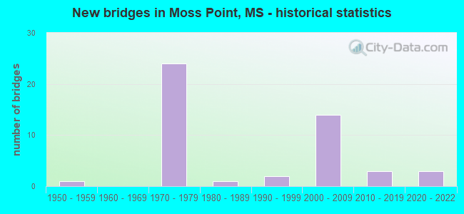
- New bridges - historical statistics
- 11950-1959
- 241970-1979
- 11980-1989
- 21990-1999
- 142000-2009
- 32010-2019
- 32020-2022


- Bridge Condition - Deck
- 22.2%Very good
- 69.4%Good
- 5.6%Satisfactory
- 2.8%Fair

- Bridge Condition - Superstructure
- 27.8%Very good
- 52.8%Good
- 13.9%Satisfactory
- 5.6%Fair

- Bridge Condition - Substructure
- 25.0%Very good
- 63.9%Good
- 11.1%Satisfactory

- Bridge Condition - Channel
- 6.5%Excellent
- 54.8%Very good
- 22.6%Good
- 12.9%Satisfactory
- 3.2%Fair

- Bridge Condition - Culverts
- 50.0%Good
- 50.0%Fair
Find on map >> Show street view
Structure Number: 11000100300707B, Location: I 10 OVER SR 63 (Lat: 30.441689, Lng: -88.528519), Route carried "under" structure: State highway 63, Year Built: 1977, Structure Length: 0. m, Average Daily Traffic: 11,000 (year 2018), Truck Traffic: 5%, Features Intersected: SR 63, Facility Carried by Structure: I 10
Minimum Vertical Clearance: 5.30m (17.39ft), Kilometerpoint: 5.993, Lanes on structure: 2, Lanes under structure: 4, Material/Design: Concrete continuous, Design/Construction: Box Beam or Girders - Single/Spread, Length of Maximum Span: 30.5m (100.1ft)
Find on map >> Show street view
Structure Number: 41000100300754, Location: 4.7 MI E SR 63 (Lat: 30.458661, Lng: -88.454600), Route carried "under" structure: Interstate 10, Year Built: 1977, Structure Length: 0. m, Average Daily Traffic: 21,000 (year 2017), Truck Traffic: 10%, Features Intersected: I 10, Facility Carried by Structure: POLLOCK ROAD
Minimum Vertical Clearance: 4.97m (16.31ft), Kilometerpoint: 5.570, Lanes on structure: 2, Lanes under structure: 4, Material/Design: Concrete continuous, Design/Construction: Box Beam or Girders - Single/Spread, Length of Maximum Span: 36.6m (120.1ft)
Find on map >> Show street view
Structure Number: 41000100300754, Location: 4.7 MI E SR 63 (Lat: 30.458239, Lng: -88.454600), Route carried "under" structure: Interstate 10, Year Built: 1977, Structure Length: 0. m, Average Daily Traffic: 21,000 (year 2017), Truck Traffic: 10%, Features Intersected: I 10, Facility Carried by Structure: POLLOCK ROAD
Minimum Vertical Clearance: 5.08m (16.67ft), Kilometerpoint: 42.258, Lanes on structure: 2, Lanes under structure: 4, Material/Design: Concrete continuous, Design/Construction: Box Beam or Girders - Single/Spread, Length of Maximum Span: 36.6m (120.1ft)