Bridge Statistics for Nampa, Idaho (ID)
Condition, Traffic, Stress, Structural Evaluation, Project Costs
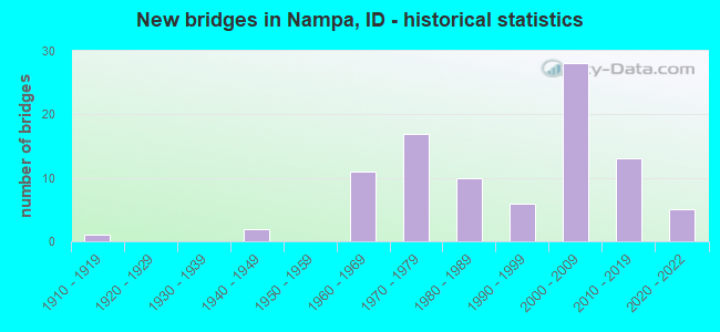
- New bridges - historical statistics
- 11910-1919
- 21940-1949
- 111960-1969
- 171970-1979
- 101980-1989
- 61990-1999
- 282000-2009
- 132010-2019
- 52020-2022

- Reconstructed bridges - Historical Statistics
- 31970-1979
- 11980-1989
- 11990-1999
- 62000-2009


- Bridge Condition - Deck
- 5.3%Excellent
- 3.9%Very good
- 51.3%Good
- 34.2%Satisfactory
- 5.3%Fair

- Bridge Condition - Superstructure
- 3.9%Excellent
- 19.7%Very good
- 34.2%Good
- 34.2%Satisfactory
- 7.9%Fair

- Bridge Condition - Substructure
- 5.3%Excellent
- 31.6%Very good
- 23.7%Good
- 31.6%Satisfactory
- 6.6%Fair
- 1.3%Poor

- Bridge Condition - Channel
- 16.4%Excellent
- 31.1%Very good
- 39.3%Good
- 11.5%Satisfactory
- 1.6%Fair

- Bridge Condition - Culverts
- 50.0%Very good
- 50.0%Good
Find on map >> Show street view
Structure Number: 26945, Location: 2.5 N. 2.4 E. NAMPA (Lat: 43.615083, Lng: -116.513167), Route carried "on" structure: County highway 8513, Year Built: 1987, Year Reconstructed: 2005, Status: Open, Structure Length: 0.82m (2.69ft), Average Daily Traffic: 17,500 (year 2019), Truck Traffic: 3%, Average Future Daily Traffic: 26,250 (year 2039), Design Load: HS 20, Features Intersected: PHYLLIS CANAL
Minimum Vertical Clearance: 30+ m (98+ ft), Kilometerpoint: 162.043, Lanes on structure: 5, Owner: City or Municipal Highway Agency, Approaching Roadway Width: 24.7m (81.0ft), Skew: 1 degrees, Material/Design: Concrete, Design/Construction: Frame, Number Of Spans In Main Unit: 1, Length of Maximum Span: 8.2m (26.9ft), Curb or Sidewalk Widths: Left: 2.1m (6.9ft), Right: 2.1m (6.9ft), Curb-To-Curb Width: 24.7m (81.0ft), Out-to-Out Width: 30.7m (100.7ft)
Condition: Deck: Satisfactory, Superstructure: Satisfactory, Substructure: Good, Channel: Good, Operating Rating: 34.5 metric tons, Method Used To Determine Operating Rating: Field evaluation and documented engineering judgment, Inventory Rating: 20.9 metric tons, Method Used To Determine Inventory Rating: Field evaluation and documented engineering judgment, Structural Evaluation: Somewhat better than minimum adequacy, Deck Geometry: Superior to present desirable criteria, Waterway Adequacy: Superior to present desirable criteria, Approach Roadway Alignment: Equal to present desirable criteria, Length Of Structure Improvement: 1.49m (4.89ft), Designated Inspection Frequency: Every 24 months, Inspection Date: Febuary 2021, Bridge Improvement Cost: $501,000, Roadway Improvement Cost: $50,000, Total Project Cost: $752,000 ( Estimate for 2021), Deck Structure Type: Concrete Precast Panels, Wearing Surface/Protective System: Wearing Surface: Bituminous
Find on map >> Show street view
Structure Number: 26965, Location: IN NAMPA (Lat: 43.599667, Lng: -116.613194), Route carried "on" structure: City street 8213, Year Built: 1970, Year Reconstructed: 1977, Status: Open, Structure Length: 1.83m (6.00ft), Average Daily Traffic: 9,100 (year 2019), Average Future Daily Traffic: 13,650 (year 2039), Design Load: HS 20, Features Intersected: ELIJA DRAIN
Minimum Vertical Clearance: 30+ m (98+ ft), Kilometerpoint: 6.655, Lanes on structure: 2, Base Highway Network: Yes (Inventory Route: 82, Subroute: 2), Owner: City or Municipal Highway Agency, Approaching Roadway Width: 10.4m (34.1ft), Skew: 3 degrees, Material/Design: Prestressed concrete, Design/Construction: Tee Beam, Number Of Spans In Main Unit: 1, Length of Maximum Span: 17.4m (57.1ft), Curb or Sidewalk Widths: Left: 0.1m (0.3ft), Right: 0.1m (0.3ft), Curb-To-Curb Width: 11.7m (38.4ft), Out-to-Out Width: 12.2m (40.0ft)
Condition: Deck: Satisfactory, Superstructure: Satisfactory, Substructure: Good, Channel: Satisfactory, Operating Rating: 34.5 metric tons, Method Used To Determine Operating Rating: Load Factor (LF), Inventory Rating: 20.9 metric tons, Method Used To Determine Inventory Rating: Load Factor (LF), Structural Evaluation: Somewhat better than minimum adequacy, Deck Geometry: Somewhat better than minimum adequacy, Waterway Adequacy: Superior to present desirable criteria, Approach Roadway Alignment: Equal to present desirable criteria, Length Of Structure Improvement: 2.53m (8.30ft), Designated Inspection Frequency: Every 24 months, Inspection Date: Febuary 2021, Bridge Improvement Cost: $657,000, Roadway Improvement Cost: $66,000, Total Project Cost: $986,000 ( Estimate for 2021), Deck Structure Type: Concrete Cast-file-Place, Wearing Surface/Protective System: Wearing Surface: Bituminous
Find on map >> Show street view
Structure Number: 27026, Location: 0.3 N 3.2 W NAMPA (Lat: 43.583139, Lng: -116.625139), Route carried "on" structure: County highway 8533, Year Built: 2010, Status: Open, Structure Length: 0.64m (2.10ft), Average Daily Traffic: 520 (year 2019), Average Future Daily Traffic: 780 (year 2039), Design Load: HS 25 or greater, Features Intersected: PHYLLIS CANAL
Minimum Vertical Clearance: 30+ m (98+ ft), Kilometerpoint: 163.184, Lanes on structure: 2, Owner: Local Agency, Approaching Roadway Width: 6.7m (22.0ft), Skew: 2 degrees, Material/Design: Concrete, Design/Construction: Frame, Number Of Spans In Main Unit: 1, Length of Maximum Span: 6.4m (21.0ft), Curb or Sidewalk Widths: Left: 0.3m (1.0ft), Right: 0.3m (1.0ft), Curb-To-Curb Width: 13.1m (43.0ft), Out-to-Out Width: 13.7m (44.9ft)
Condition: Deck: Very good, Superstructure: Very good, Substructure: Very good, Channel: Excellent, Operating Rating: 90.6 metric tons, Method Used To Determine Operating Rating: Load Factor (LF), Inventory Rating: 55.3 metric tons, Method Used To Determine Inventory Rating: Load Factor (LF), Structural Evaluation: Equal to present desirable criteria, Deck Geometry: Superior to present desirable criteria, Waterway Adequacy: Equal to present desirable criteria, Approach Roadway Alignment: Equal to present desirable criteria, Designated Inspection Frequency: Every 48 months, Inspection Date: March 2018, Deck Structure Type: Concrete Precast Panels, Wearing Surface/Protective System: Wearing Surface: Bituminous
Find on map >> Show street view
Structure Number: 27035, Location: 0.3 N. 3.1 W. NAMPA (Lat: 43.583139, Lng: -116.623250), Route carried "on" structure: County highway , Year Built: 1970, Status: Open, Structure Length: 1.86m (6.10ft), Average Daily Traffic: 520 (year 2019), Average Future Daily Traffic: 780 (year 2039), Design Load: H 20, Features Intersected: WILSON DRAIN, Facility Carried by Structure: SMITH AVENUE
Minimum Vertical Clearance: 30+ m (98+ ft), Kilometerpoint: 163.342, Lanes on structure: 2, Owner: Local Agency, Approaching Roadway Width: 7.6m (24.9ft), Skew: 3 degrees, Material/Design: Prestressed concrete, Design/Construction: Tee Beam, Number Of Spans In Main Unit: 1, Length of Maximum Span: 17.7m (58.1ft), Curb or Sidewalk Widths: Left: 0.2m (0.7ft), Right: 0.2m (0.7ft), Curb-To-Curb Width: 8.1m (26.6ft), Out-to-Out Width: 8.6m (28.2ft)
Condition: Deck: Satisfactory, Superstructure: Satisfactory, Substructure: Good, Channel: Good, Operating Rating: 42.6 metric tons, Method Used To Determine Operating Rating: Load Factor (LF), Inventory Rating: 20.9 metric tons, Method Used To Determine Inventory Rating: Load Factor (LF), Structural Evaluation: Somewhat better than minimum adequacy, Deck Geometry: Somewhat better than minimum adequacy, Waterway Adequacy: Superior to present desirable criteria, Approach Roadway Alignment: Equal to present desirable criteria, Length Of Structure Improvement: 2.62m (8.60ft), Designated Inspection Frequency: Every 24 months, Inspection Date: March 2020, Bridge Improvement Cost: $426,000, Roadway Improvement Cost: $43,000, Total Project Cost: $639,000 ( Estimate for 2017), Deck Structure Type: Concrete Cast-file-Place, Wearing Surface/Protective System: Wearing Surface: Bituminous
Find on map >> Show street view
Structure Number: 2704, Location: 0.3 N. 2.9 W. NAMPA (Lat: 43.583167, Lng: -116.619389), Route carried "on" structure: City street , Year Built: 1971, Year Reconstructed: 2008, Status: Open, Structure Length: 0.94m (3.08ft), Average Daily Traffic: 520 (year 2019), Average Future Daily Traffic: 780 (year 2039), Design Load: H 20, Features Intersected: PHYLLIS CANAL, Facility Carried by Structure: SMITH AVENUE
Minimum Vertical Clearance: 30+ m (98+ ft), Kilometerpoint: 163.646, Lanes on structure: 2, Owner: City or Municipal Highway Agency, Approaching Roadway Width: 7.6m (24.9ft), Skew: 4 degrees, Material/Design: Prestressed concrete, Design/Construction: Tee Beam, Number Of Spans In Main Unit: 1, Length of Maximum Span: 8.2m (26.9ft), Curb or Sidewalk Widths: Left: 1.7m (5.6ft), Right: 0.0m, Curb-To-Curb Width: 9.8m (32.2ft), Out-to-Out Width: 14.2m (46.6ft)
Condition: Deck: Satisfactory, Superstructure: Satisfactory, Substructure: Satisfactory, Channel: Good, Operating Rating: 34.5 metric tons, Method Used To Determine Operating Rating: Field evaluation and documented engineering judgment, Inventory Rating: 20.9 metric tons, Method Used To Determine Inventory Rating: Field evaluation and documented engineering judgment, Structural Evaluation: Somewhat better than minimum adequacy, Deck Geometry: Equal to present minimum criteria, Waterway Adequacy: Better than present minimum criteria, Approach Roadway Alignment: Equal to present desirable criteria, Designated Inspection Frequency: Every 24 months, Inspection Date: Febuary 2021, Deck Structure Type: Concrete Cast-file-Place, Wearing Surface/Protective System: Wearing Surface: Bituminous
Find on map >> Show street view
Structure Number: 27148, Location: 3.2 S. 4.9 W. NAMPA (Lat: 43.531833, Lng: -116.659583), Route carried "on" structure: County highway 3747, Year Built: 1997, Status: Open, Structure Length: 0.73m (2.40ft), Average Daily Traffic: 1,200 (year 2019), Truck Traffic: 5%, Average Future Daily Traffic: 1,800 (year 2039), Design Load: HS 20, Features Intersected: DEER FLAT HIGH LINE CNL
Minimum Vertical Clearance: 30+ m (98+ ft), Kilometerpoint: 170.043, Lanes on structure: 2, Owner: Local Agency, Approaching Roadway Width: 6.1m (20.0ft), Skew: 4 degrees, Material/Design: Concrete, Design/Construction: Frame, Number Of Spans In Main Unit: 1, Length of Maximum Span: 6.9m (22.6ft), Curb or Sidewalk Widths: Left: 0.2m (0.7ft), Right: 0.2m (0.7ft), Curb-To-Curb Width: 14.8m (48.6ft), Out-to-Out Width: 15.2m (49.9ft)
Condition: Deck: Satisfactory, Superstructure: Satisfactory, Substructure: Good, Channel: Very good, Operating Rating: 47.2 metric tons, Method Used To Determine Operating Rating: Field evaluation and documented engineering judgment, Inventory Rating: 28.1 metric tons, Method Used To Determine Inventory Rating: Field evaluation and documented engineering judgment, Structural Evaluation: Equal to present minimum criteria, Deck Geometry: Superior to present desirable criteria, Waterway Adequacy: Superior to present desirable criteria, Approach Roadway Alignment: Equal to present desirable criteria, Designated Inspection Frequency: Every 24 months, Inspection Date: March 2021, Deck Structure Type: Concrete Precast Panels, Wearing Surface/Protective System: Wearing Surface: Bituminous, Membrane: Other, Deck Protection: Epoxy Coated Reinforcing
Find on map >> Show street view
Structure Number: 2721, Location: 4.2 S. 1.1 E. NAMPA (Lat: 43.517353, Lng: -116.540214), Route carried "on" structure: County highway , Year Built: 1984, Status: Open, Structure Length: 1.55m (5.09ft), Average Daily Traffic: 1,700 (year 2019), Average Future Daily Traffic: 2,550 (year 2039), Design Load: HS 20, Features Intersected: NEW YORK CANAL, Facility Carried by Structure: LEWIS LANE
Minimum Vertical Clearance: 30+ m (98+ ft), Kilometerpoint: 163.569, Lanes on structure: 2, Owner: Local Agency, Approaching Roadway Width: 9.1m (29.9ft), Material/Design: Prestressed concrete, Design/Construction: Tee Beam, Number Of Spans In Main Unit: 1, Length of Maximum Span: 15.2m (49.9ft), Curb-To-Curb Width: 12.3m (40.4ft), Out-to-Out Width: 12.9m (42.3ft)
Condition: Deck: Good, Superstructure: Good, Substructure: Satisfactory, Channel: Good, Operating Rating: 39.9 metric tons, Method Used To Determine Operating Rating: Load Factor (LF), Inventory Rating: 9.1 metric tons, Method Used To Determine Inventory Rating: Load Factor (LF), Structural Evaluation: High priority of corrective action, Deck Geometry: Better than present minimum criteria, Waterway Adequacy: Better than present minimum criteria, Approach Roadway Alignment: Equal to present desirable criteria, Designated Inspection Frequency: Every 24 months, Inspection Date: Febuary 2020, Deck Structure Type: Concrete Cast-file-Place, Wearing Surface/Protective System: Wearing Surface: Bituminous
Find on map >> Show street view
Structure Number: 2725, Location: 4.8 S. 0.4 E. NAMPA (Lat: 43.507664, Lng: -116.553022), Route carried "on" structure: County highway , Year Built: 1919, Year Reconstructed: 1987, Status: Open, Structure Length: 1.71m (5.61ft), Average Daily Traffic: 920 (year 2019), Average Future Daily Traffic: 1,380 (year 2039), Design Load: HS 20, Features Intersected: NEW YORK CANAL, Facility Carried by Structure: POWER LINE ROAD
Minimum Vertical Clearance: 30+ m (98+ ft), Kilometerpoint: 21.327, Lanes on structure: 2, Owner: Local Agency, Approaching Roadway Width: 7.9m (25.9ft), Material/Design: Concrete, Design/Construction: Frame, Number Of Spans In Main Unit: 2, Length of Maximum Span: 8.2m (26.9ft), Curb-To-Curb Width: 13.1m (43.0ft), Out-to-Out Width: 13.9m (45.6ft)
Condition: Deck: Good, Superstructure: Good, Substructure: Good, Channel: Good, Operating Rating: 47.2 metric tons, Method Used To Determine Operating Rating: Field evaluation and documented engineering judgment, Inventory Rating: 28.1 metric tons, Method Used To Determine Inventory Rating: Field evaluation and documented engineering judgment, Structural Evaluation: Better than present minimum criteria, Deck Geometry: Superior to present desirable criteria, Waterway Adequacy: Better than present minimum criteria, Approach Roadway Alignment: Equal to present desirable criteria, Designated Inspection Frequency: Every 24 months, Inspection Date: Febuary 2020, Deck Structure Type: Concrete Precast Panels, Wearing Surface/Protective System: Wearing Surface: Bituminous
Find on map >> Show street view
Structure Number: 2726, Location: 6.2S 4.1W NAMPA CITY CTR (Lat: 43.488333, Lng: -116.644000), Route carried "on" structure: County highway 3725, Year Built: 1984, Status: Open, Structure Length: 0.94m (3.08ft), Average Daily Traffic: 1,100 (year 2019), Truck Traffic: 4%, Average Future Daily Traffic: 1,650 (year 2039), Design Load: HS 20, Features Intersected: MORA CANAL
Minimum Vertical Clearance: 30+ m (98+ ft), Kilometerpoint: 167.563, Lanes on structure: 2, Owner: Local Agency, Approaching Roadway Width: 8.5m (27.9ft), Skew: 1 degrees, Material/Design: Prestressed concrete, Design/Construction: Tee Beam, Number Of Spans In Main Unit: 1, Length of Maximum Span: 8.8m (28.9ft), Curb-To-Curb Width: 14.2m (46.6ft), Out-to-Out Width: 14.8m (48.6ft)
Condition: Deck: Good, Superstructure: Good, Substructure: Satisfactory, Channel: Very good, Operating Rating: 47.2 metric tons, Method Used To Determine Operating Rating: Field evaluation and documented engineering judgment, Inventory Rating: 28.1 metric tons, Method Used To Determine Inventory Rating: Field evaluation and documented engineering judgment, Structural Evaluation: Equal to present minimum criteria, Deck Geometry: Superior to present desirable criteria, Waterway Adequacy: Equal to present desirable criteria, Approach Roadway Alignment: Equal to present desirable criteria, Designated Inspection Frequency: Every 24 months, Inspection Date: Febuary 2021, Deck Structure Type: Concrete Cast-file-Place, Wearing Surface/Protective System: Wearing Surface: Bituminous
Find on map >> Show street view
Structure Number: 27271, Location: 4.2 S 3.8 W NAMPA CITY CT (Lat: 43.517417, Lng: -116.637389), Route carried "on" structure: County highway , Year Built: 2005, Status: Open, Structure Length: 0.67m (2.20ft), Average Daily Traffic: 90 (year 2019), Truck Traffic: 10%, Average Future Daily Traffic: 135 (year 2039), Design Load: HS 25 or greater, Features Intersected: MORA CANAL, Facility Carried by Structure: LEWIS LANE
Minimum Vertical Clearance: 30+ m (98+ ft), Kilometerpoint: 167.043, Lanes on structure: 2, Owner: Local Agency, Approaching Roadway Width: 9.8m (32.2ft), Material/Design: Concrete, Design/Construction: Frame, Number Of Spans In Main Unit: 1, Length of Maximum Span: 6.7m (22.0ft), Curb or Sidewalk Widths: Left: 0.3m (1.0ft), Right: 0.3m (1.0ft), Curb-To-Curb Width: 14.6m (47.9ft), Out-to-Out Width: 15.2m (49.9ft)
Condition: Deck: Good, Superstructure: Good, Substructure: Very good, Channel: Excellent, Operating Rating: 87.1 metric tons, Method Used To Determine Operating Rating: Load Factor (LF), Inventory Rating: 51.7 metric tons, Method Used To Determine Inventory Rating: Load Factor (LF), Structural Evaluation: Better than present minimum criteria, Deck Geometry: Superior to present desirable criteria, Waterway Adequacy: Superior to present desirable criteria, Approach Roadway Alignment: Equal to present desirable criteria, Designated Inspection Frequency: Every 48 months, Inspection Date: Febuary 2021, Deck Structure Type: Concrete Precast Panels, Wearing Surface/Protective System: Wearing Surface: Bituminous
Find on map >> Show street view
Structure Number: 27342, Location: IN NAMPA (Lat: 43.608222, Lng: -116.532306), Route carried "on" structure: City street 8433, Year Built: 1994, Status: Open, Structure Length: 0.79m (2.59ft), Average Daily Traffic: 2,600 (year 2019), Truck Traffic: 7%, Average Future Daily Traffic: 3,900 (year 2039), Design Load: HS 20, Features Intersected: PHYLLIS CNL;11TH AVE EXT
Minimum Vertical Clearance: 30+ m (98+ ft), Kilometerpoint: 3.724, Lanes on structure: 2, Owner: City or Municipal Highway Agency, Approaching Roadway Width: 10.4m (34.1ft), Material/Design: Concrete, Design/Construction: Frame, Number Of Spans In Main Unit: 1, Length of Maximum Span: 7.9m (25.9ft), Curb or Sidewalk Widths: Left: 0.3m (1.0ft), Right: 0.3m (1.0ft), Curb-To-Curb Width: 10.4m (34.1ft), Out-to-Out Width: 19.8m (65.0ft)
Condition: Deck: Fair, Superstructure: Fair, Substructure: Satisfactory, Channel: Good, Operating Rating: 27.2 metric tons, Method Used To Determine Operating Rating: Field evaluation and documented engineering judgment, Inventory Rating: 16.3 metric tons, Method Used To Determine Inventory Rating: Field evaluation and documented engineering judgment, Structural Evaluation: Meets minimum limits, Deck Geometry: Somewhat better than minimum adequacy, Waterway Adequacy: Superior to present desirable criteria, Approach Roadway Alignment: Equal to present desirable criteria, Length Of Structure Improvement: 1.46m (4.79ft), Designated Inspection Frequency: Every 24 months, Inspection Date: March 2021, Bridge Improvement Cost: $348,000, Roadway Improvement Cost: $35,000, Total Project Cost: $523,000 ( Estimate for 2021), Deck Structure Type: Concrete Precast Panels, Wearing Surface/Protective System: Wearing Surface: Bituminous
Find on map >> Show street view
Structure Number: 27381, Location: 3.8S 2.4E NAMPA CITY CTR (Lat: 43.523333, Lng: -116.513333), Route carried "on" structure: County highway 7839, Year Built: 2004, Status: Open, Structure Length: 3.14m (10.30ft), Average Daily Traffic: 610 (year 2019), Average Future Daily Traffic: 915 (year 2039), Design Load: HS 25 or greater, Features Intersected: NEW YORK CANAL
Minimum Vertical Clearance: 30+ m (98+ ft), Kilometerpoint: 24.617, Lanes on structure: 2, Owner: Local Agency, Approaching Roadway Width: 7.5m (24.6ft), Skew: 4 degrees, Material/Design: Prestressed concrete, Design/Construction: Stringer/Multi-beam, Number Of Spans In Main Unit: 1, Length of Maximum Span: 28.3m (92.8ft), Curb-To-Curb Width: 14.1m (46.3ft), Out-to-Out Width: 14.9m (48.9ft)
Condition: Deck: Very good, Superstructure: Very good, Substructure: Good, Channel: Excellent, Operating Rating: 86.2 metric tons, Method Used To Determine Operating Rating: Load Factor (LF), Inventory Rating: 50.8 metric tons, Method Used To Determine Inventory Rating: Load Factor (LF), Structural Evaluation: Better than present minimum criteria, Deck Geometry: Superior to present desirable criteria, Waterway Adequacy: Equal to present desirable criteria, Approach Roadway Alignment: Equal to present desirable criteria, Designated Inspection Frequency: Every 48 months, Inspection Date: Febuary 2018, Deck Structure Type: Concrete Cast-file-Place, Wearing Surface/Protective System: Wearing Surface: Bituminous, Deck Protection: Epoxy Coated Reinforcing
Find on map >> Show street view
Structure Number: 27405, Location: 5.2 S. 1.2 W. NAMPA (Lat: 43.502889, Lng: -116.585000), Route carried "on" structure: County highway 3756, Year Built: 1990, Status: Open, Structure Length: 1.92m (6.30ft), Average Daily Traffic: 860 (year 2019), Truck Traffic: 1%, Average Future Daily Traffic: 1,290 (year 2039), Design Load: HS 20, Features Intersected: HIGH LINE CANAL
Minimum Vertical Clearance: 30+ m (98+ ft), Kilometerpoint: 169.668, Lanes on structure: 2, Owner: Local Agency, Approaching Roadway Width: 7.3m (24.0ft), Skew: 6 degrees, Material/Design: Concrete, Design/Construction: Frame, Number Of Spans In Main Unit: 1, Length of Maximum Span: 19.2m (63.0ft), Curb-To-Curb Width: 8.5m (27.9ft), Out-to-Out Width: 15.0m (49.2ft)
Condition: Deck: Satisfactory, Superstructure: Satisfactory, Substructure: Good, Channel: Very good, Inventory Rating: 74.4 metric tons, Method Used To Determine Inventory Rating: Load Factor (LF), Structural Evaluation: Equal to present minimum criteria, Deck Geometry: Somewhat better than minimum adequacy, Waterway Adequacy: Superior to present desirable criteria, Approach Roadway Alignment: Equal to present desirable criteria, Length Of Structure Improvement: 2.80m (9.19ft), Designated Inspection Frequency: Every 48 months, Inspection Date: March 2021, Bridge Improvement Cost: $455,000, Roadway Improvement Cost: $46,000, Total Project Cost: $683,000 ( Estimate for 2021), Deck Structure Type: Concrete Precast Panels, Wearing Surface/Protective System: Wearing Surface: Bituminous
Find on map >> Show street view
Structure Number: 27407, Location: 4.0 E NAMPA (Lat: 43.575833, Lng: -116.481833), Route carried "on" structure: County highway 8443, Year Built: 1980, Status: Open, Structure Length: 0.67m (2.20ft), Average Daily Traffic: 2,300 (year 2019), Truck Traffic: 1%, Average Future Daily Traffic: 3,450 (year 2039), Design Load: HS 20, Features Intersected: RIDENBAUGH CANAL
Minimum Vertical Clearance: 30+ m (98+ ft), Kilometerpoint: 16.085, Lanes on structure: 2, Owner: Local Agency, Approaching Roadway Width: 7.9m (25.9ft), Skew: 4 degrees, Material/Design: Concrete, Design/Construction: Frame, Number Of Spans In Main Unit: 1, Length of Maximum Span: 6.7m (22.0ft), Curb or Sidewalk Widths: Left: 0.3m (1.0ft), Right: 0.3m (1.0ft), Curb-To-Curb Width: 14.8m (48.6ft), Out-to-Out Width: 15.4m (50.5ft)
Condition: Deck: Satisfactory, Superstructure: Satisfactory, Substructure: Satisfactory, Channel: Very good, Operating Rating: 34.5 metric tons, Method Used To Determine Operating Rating: Field evaluation and documented engineering judgment, Inventory Rating: 20.9 metric tons, Method Used To Determine Inventory Rating: Field evaluation and documented engineering judgment, Structural Evaluation: Somewhat better than minimum adequacy, Deck Geometry: Superior to present desirable criteria, Waterway Adequacy: Equal to present desirable criteria, Approach Roadway Alignment: Equal to present desirable criteria, Length Of Structure Improvement: 1.28m (4.20ft), Designated Inspection Frequency: Every 24 months, Inspection Date: March 2020, Bridge Improvement Cost: $305,000, Roadway Improvement Cost: $31,000, Total Project Cost: $458,000 ( Estimate for 2018), Deck Structure Type: Concrete Precast Panels, Wearing Surface/Protective System: Wearing Surface: Bituminous
Find on map >> Show street view
Structure Number: 2741, Location: 3.3 S. 3.5 E. NAMPA (Lat: 43.529797, Lng: -116.493508), Route carried "on" structure: County highway 3723, Year Built: 1981, Year Reconstructed: 2000, Status: Open, Structure Length: 1.62m (5.31ft), Average Daily Traffic: 2,200 (year 2019), Truck Traffic: 5%, Average Future Daily Traffic: 3,300 (year 2039), Design Load: HS 20, Features Intersected: NEW YORK CANAL
Minimum Vertical Clearance: 30+ m (98+ ft), Kilometerpoint: 9.027, Lanes on structure: 2, Owner: Local Agency, Approaching Roadway Width: 9.8m (32.2ft), Skew: 1 degrees, Material/Design: Prestressed concrete, Design/Construction: Tee Beam, Number Of Spans In Main Unit: 1, Length of Maximum Span: 15.5m (50.9ft), Curb-To-Curb Width: 15.6m (51.2ft), Out-to-Out Width: 16.2m (53.1ft)
Condition: Deck: Good, Superstructure: Satisfactory, Substructure: Good, Channel: Very good, Operating Rating: 48.1 metric tons, Method Used To Determine Operating Rating: Load Factor (LF), Inventory Rating: 21.8 metric tons, Method Used To Determine Inventory Rating: Load Factor (LF), Structural Evaluation: Somewhat better than minimum adequacy, Deck Geometry: Superior to present desirable criteria, Waterway Adequacy: Equal to present desirable criteria, Approach Roadway Alignment: Equal to present desirable criteria, Designated Inspection Frequency: Every 24 months, Inspection Date: Febuary 2020, Deck Structure Type: Concrete Cast-file-Place, Wearing Surface/Protective System: Wearing Surface: Bituminous
Find on map >> Show street view
Structure Number: 2743, Location: 3.2S 3.7E NAMPA CITY CTR (Lat: 43.532222, Lng: -116.490556), Route carried "on" structure: County highway 3343, Year Built: 1988, Status: Open, Structure Length: 1.95m (6.40ft), Average Daily Traffic: 1,000 (year 2019), Average Future Daily Traffic: 1,500 (year 2039), Design Load: HS 20, Features Intersected: NEW YORK CANAL
Minimum Vertical Clearance: 30+ m (98+ ft), Kilometerpoint: 9.511, Lanes on structure: 2, Owner: Local Agency, Approaching Roadway Width: 6.4m (21.0ft), Skew: 3 degrees, Material/Design: Prestressed concrete, Design/Construction: Tee Beam, Number Of Spans In Main Unit: 1, Length of Maximum Span: 19.2m (63.0ft), Curb-To-Curb Width: 14.3m (46.9ft), Out-to-Out Width: 15.2m (49.9ft)
Condition: Deck: Good, Superstructure: Good, Substructure: Satisfactory, Channel: Very good, Operating Rating: 45.9 metric tons, Method Used To Determine Operating Rating: Allowable Stress (AS), Inventory Rating: 25.2 metric tons, Method Used To Determine Inventory Rating: Allowable Stress (AS), Structural Evaluation: Equal to present minimum criteria, Deck Geometry: Superior to present desirable criteria, Waterway Adequacy: Better than present minimum criteria, Approach Roadway Alignment: Equal to present desirable criteria, Designated Inspection Frequency: Every 48 months, Inspection Date: Febuary 2018, Deck Structure Type: Concrete Cast-file-Place, Wearing Surface/Protective System: Wearing Surface: Bituminous
Find on map >> Show street view
Structure Number: 27446, Location: 5.2 S. 2.3 W. NAMPA (Lat: 43.502972, Lng: -116.608083), Route carried "on" structure: County highway 3756, Year Built: 1991, Status: Open, Structure Length: 1.59m (5.22ft), Average Daily Traffic: 860 (year 2019), Truck Traffic: 1%, Average Future Daily Traffic: 1,290 (year 2039), Design Load: HS 20, Features Intersected: HIGH LINE CANAL
Minimum Vertical Clearance: 30+ m (98+ ft), Kilometerpoint: 167.787, Lanes on structure: 2, Owner: Local Agency, Approaching Roadway Width: 8.2m (26.9ft), Skew: 6 degrees, Material/Design: Concrete, Design/Construction: Frame, Number Of Spans In Main Unit: 1, Length of Maximum Span: 15.9m (52.2ft), Curb-To-Curb Width: 17.1m (56.1ft), Out-to-Out Width: 23.3m (76.4ft)
Condition: Deck: Good, Superstructure: Good, Substructure: Good, Channel: Very good, Operating Rating: 83.5 metric tons, Method Used To Determine Operating Rating: Load Factor (LF), Inventory Rating: 49.9 metric tons, Method Used To Determine Inventory Rating: Load Factor (LF), Structural Evaluation: Better than present minimum criteria, Deck Geometry: Superior to present desirable criteria, Waterway Adequacy: Equal to present desirable criteria, Approach Roadway Alignment: Better than present minimum criteria, Designated Inspection Frequency: Every 48 months, Inspection Date: March 2020, Deck Structure Type: Concrete Precast Panels, Wearing Surface/Protective System: Wearing Surface: Bituminous
Find on map >> Show street view
Structure Number: 27501, Location: 5.2 S. 3.7 W. NAMPA (Lat: 43.502864, Lng: -116.635603), Route carried "on" structure: County highway 3756, Year Built: 2006, Status: Open, Structure Length: 0.91m (2.99ft), Average Daily Traffic: 240 (year 2019), Truck Traffic: 4%, Average Future Daily Traffic: 360 (year 2039), Design Load: HS 25 or greater, Features Intersected: MORA CANAL
Minimum Vertical Clearance: 30+ m (98+ ft), Kilometerpoint: 165.577, Lanes on structure: 2, Owner: Local Agency, Approaching Roadway Width: 6.7m (22.0ft), Skew: 2 degrees, Material/Design: Concrete, Design/Construction: Frame, Number Of Spans In Main Unit: 1, Length of Maximum Span: 9.1m (29.9ft), Curb or Sidewalk Widths: Left: 0.3m (1.0ft), Right: 0.3m (1.0ft), Curb-To-Curb Width: 14.9m (48.9ft), Out-to-Out Width: 15.5m (50.9ft)
Condition: Deck: Good, Superstructure: Good, Substructure: Very good, Channel: Very good, Inventory Rating: 68.9 metric tons, Method Used To Determine Inventory Rating: Load Factor (LF), Structural Evaluation: Better than present minimum criteria, Deck Geometry: Superior to present desirable criteria, Waterway Adequacy: Better than present minimum criteria, Approach Roadway Alignment: Equal to present desirable criteria, Designated Inspection Frequency: Every 48 months, Inspection Date: Febuary 2020, Deck Structure Type: Concrete Precast Panels, Wearing Surface/Protective System: Wearing Surface: Bituminous
Find on map >> Show street view
Structure Number: 2754, Location: 4.7S 0.9W NAMPA CITY CTR (Lat: 43.510139, Lng: -116.579778), Route carried "on" structure: County highway 3747, Year Built: 1986, Status: Open, Structure Length: 1.92m (6.30ft), Average Daily Traffic: 2,100 (year 2019), Truck Traffic: 3%, Average Future Daily Traffic: 3,150 (year 2039), Design Load: HS 20, Features Intersected: NEW YORK CANAL
Minimum Vertical Clearance: 30+ m (98+ ft), Kilometerpoint: 165.241, Lanes on structure: 2, Owner: Local Agency, Approaching Roadway Width: 8.5m (27.9ft), Skew: 3 degrees, Material/Design: Concrete, Design/Construction: Frame, Number Of Spans In Main Unit: 2, Length of Maximum Span: 9.4m (30.8ft), Curb-To-Curb Width: 14.1m (46.3ft), Out-to-Out Width: 14.7m (48.2ft)
Condition: Deck: Good, Superstructure: Good, Substructure: Good, Channel: Good, Operating Rating: 47.2 metric tons, Method Used To Determine Operating Rating: Field evaluation and documented engineering judgment, Inventory Rating: 28.1 metric tons, Method Used To Determine Inventory Rating: Field evaluation and documented engineering judgment, Structural Evaluation: Better than present minimum criteria, Deck Geometry: Superior to present desirable criteria, Waterway Adequacy: Equal to present desirable criteria, Approach Roadway Alignment: Equal to present desirable criteria, Designated Inspection Frequency: Every 24 months, Inspection Date: November 2020, Deck Structure Type: Concrete Cast-file-Place, Wearing Surface/Protective System: Wearing Surface: Bituminous
Find on map >> Show street view
Structure Number: 27556, Location: 4.0 S 3.6 W NAMPA CITY CN (Lat: 43.521361, Lng: -116.633083), Route carried "on" structure: County highway , Year Built: 2013, Status: Open, Structure Length: 0.76m (2.49ft), Average Daily Traffic: 120 (year 2019), Truck Traffic: 17%, Average Future Daily Traffic: 180 (year 2039), Design Load: HS 25 or greater, Features Intersected: DEER FLAT HIGH LINE, Facility Carried by Structure: RIM ROAD
Minimum Vertical Clearance: 30+ m (98+ ft), Kilometerpoint: 175.925, Lanes on structure: 2, Owner: Local Agency, Approaching Roadway Width: 8.5m (27.9ft), Skew: 3 degrees, Material/Design: Concrete, Design/Construction: Frame, Number Of Spans In Main Unit: 1, Length of Maximum Span: 7.6m (24.9ft), Curb-To-Curb Width: 9.8m (32.2ft), Out-to-Out Width: 15.2m (49.9ft)
Condition: Deck: Good, Superstructure: Good, Substructure: Very good, Channel: Excellent, Operating Rating: 90.6 metric tons, Method Used To Determine Operating Rating: Load Factor (LF), Inventory Rating: 69.9 metric tons, Method Used To Determine Inventory Rating: Load Factor (LF), Structural Evaluation: Better than present minimum criteria, Deck Geometry: Better than present minimum criteria, Waterway Adequacy: Better than present minimum criteria, Approach Roadway Alignment: Equal to present desirable criteria, Designated Inspection Frequency: Every 48 months, Inspection Date: March 2019, Deck Structure Type: Concrete Precast Panels, Wearing Surface/Protective System: Wearing Surface: Bituminous, Membrane: Preformed Fabric
Find on map >> Show street view
Structure Number: 27565, Location: IN NAMPA (Lat: 43.594500, Lng: -116.573111), Route carried "on" structure: City street , Year Built: 1948, Status: Open, Structure Length: 0.85m (2.79ft), Average Daily Traffic: 20 (year 2019), Truck Traffic: 10%, Average Future Daily Traffic: 30 (year 2039), Design Load: HS 20, Features Intersected: INDIAN CREEK, Facility Carried by Structure: BROADMORE WAY
Minimum Vertical Clearance: 30+ m (98+ ft), Kilometerpoint: 7.582, Lanes on structure: 2, Owner: City or Municipal Highway Agency, Approaching Roadway Width: 7.3m (24.0ft), Material/Design: Steel, Design/Construction: Stringer/Multi-beam, Number Of Spans In Main Unit: 1, Length of Maximum Span: 8.0m (26.2ft), Curb-To-Curb Width: 5.9m (19.4ft), Out-to-Out Width: 6.1m (20.0ft)
Condition: Deck: Satisfactory, Superstructure: Satisfactory, Substructure: Fair, Channel: Very good, Operating Rating: 57.2 metric tons, Method Used To Determine Operating Rating: Load Factor (LF), Inventory Rating: 33.6 metric tons, Method Used To Determine Inventory Rating: Load Factor (LF), Structural Evaluation: Somewhat better than minimum adequacy, Deck Geometry: Meets minimum limits, Waterway Adequacy: Equal to present desirable criteria, Approach Roadway Alignment: Equal to present minimum criteria, Length Of Structure Improvement: 1.49m (4.89ft), Designated Inspection Frequency: Every 24 months, Inspection Date: Febuary 2021, Bridge Improvement Cost: $226,000, Roadway Improvement Cost: $23,000, Total Project Cost: $339,000 ( Estimate for 2019), Deck Structure Type: Wood or Timber, Wearing Surface/Protective System: Wearing Surface: Bituminous
Find on map >> Show street view
Structure Number: 27644, Location: 4.8 N 0.3 E NAMPA (Lat: 43.648639, Lng: -116.555639), Route carried "on" structure: County highway , Year Built: 2013, Status: Open, Structure Length: 0.79m (2.59ft), Average Daily Traffic: 1,500 (year 2019), Average Future Daily Traffic: 2,250 (year 2039), Design Load: HS 25 or greater, Features Intersected: FIFTEEN MILE CREEK, Facility Carried by Structure: LINDEN ROAD
Minimum Vertical Clearance: 30+ m (98+ ft), Kilometerpoint: 22.328, Lanes on structure: 2, Owner: Local Agency, Approaching Roadway Width: 7.3m (24.0ft), Skew: 5 degrees, Material/Design: Steel, Design/Construction: Culvert, Number Of Spans In Main Unit: 1, Length of Maximum Span: 7.9m (25.9ft), Curb-To-Curb Width: 7.8m (25.6ft), Out-to-Out Width: 21.9m (71.9ft)
Condition: Channel: Excellent, Culverts: Very good, Operating Rating: 83.5 metric tons, Method Used To Determine Operating Rating: Load Factor (LF), Inventory Rating: 83.5 metric tons, Method Used To Determine Inventory Rating: Load Factor (LF), Structural Evaluation: Equal to present desirable criteria, Deck Geometry: Meets minimum limits, Waterway Adequacy: Equal to present desirable criteria, Approach Roadway Alignment: Equal to present desirable criteria, Designated Inspection Frequency: Every 48 months, Inspection Date: Febuary 2019
Find on map >> Show street view
Structure Number: 27646, Location: 1.5 E. NAMPA ECL (Lat: 43.598917, Lng: -116.493556), Route carried "on" structure: County highway 7859, Year Built: 2009, Status: Open, Structure Length: 5.97m (19.59ft), Average Daily Traffic: 4,300 (year 2019), Truck Traffic: 5%, Average Future Daily Traffic: 6,450 (year 2039), Design Load: HL 93, Features Intersected: I 84; ROBINSON RD GS
Minimum Vertical Clearance: 30+ m (98+ ft), Kilometerpoint: 6.611, Lanes on structure: 2, Lanes under structure: 8, Owner: State Highway Agency, Approaching Roadway Width: 12.2m (40.0ft), Material/Design: Prestressed concrete, Design/Construction: Stringer/Multi-beam, Number Of Spans In Main Unit: 2, Length of Maximum Span: 29.6m (97.1ft), Curb-To-Curb Width: 13.2m (43.3ft), Out-to-Out Width: 14.0m (45.9ft)
Condition: Deck: Good, Superstructure: Fair, Substructure: Very good, Operating Rating: 73.5 metric tons, Method Used To Determine Operating Rating: Load Factor (LF), Inventory Rating: 38.1 metric tons, Method Used To Determine Inventory Rating: Load Factor (LF), Structural Evaluation: Somewhat better than minimum adequacy, Deck Geometry: Equal to present minimum criteria, Underclear: Meets minimum limits, Approach Roadway Alignment: Equal to present desirable criteria, Designated Inspection Frequency: Every 24 months, Inspection Date: October 2021, Deck Structure Type: Concrete Cast-file-Place, Wearing Surface/Protective System: Wearing Surface: Epoxy Overlay, Deck Protection: Epoxy Coated Reinforcing
Find on map >> Show street view
Structure Number: 27676, Location: IN NAMPA (Lat: 43.588167, Lng: -116.578083), Route carried "on" structure: City street 8373, Year Built: 2003, Status: Open, Structure Length: 0.79m (2.59ft), Average Daily Traffic: 3,900 (year 2019), Average Future Daily Traffic: 5,850 (year 2039), Design Load: HS 25 or greater, Features Intersected: PHYLLIS CANAL
Minimum Vertical Clearance: 30+ m (98+ ft), Kilometerpoint: 17.503, Lanes on structure: 3, Owner: City or Municipal Highway Agency, Approaching Roadway Width: 12.2m (40.0ft), Skew: 3 degrees, Material/Design: Concrete, Design/Construction: Frame, Number Of Spans In Main Unit: 1, Length of Maximum Span: 7.9m (25.9ft), Curb or Sidewalk Widths: Left: 6.1m (20.0ft), Right: 5.8m (19.0ft), Curb-To-Curb Width: 22.1m (72.5ft), Out-to-Out Width: 35.8m (117.5ft)
Condition: Deck: Satisfactory, Superstructure: Satisfactory, Substructure: Satisfactory, Channel: Very good, Operating Rating: 54.4 metric tons, Method Used To Determine Operating Rating: Load Factor (LF), Inventory Rating: 32.7 metric tons, Method Used To Determine Inventory Rating: Load Factor (LF), Structural Evaluation: Equal to present minimum criteria, Deck Geometry: Superior to present desirable criteria, Waterway Adequacy: Superior to present desirable criteria, Approach Roadway Alignment: Equal to present minimum criteria, Designated Inspection Frequency: Every 24 months, Inspection Date: Febuary 2021, Deck Structure Type: Concrete Cast-file-Place, Wearing Surface/Protective System: Wearing Surface: Bituminous, Membrane: Preformed Fabric
Find on map >> Show street view
Structure Number: 2768, Location: IN NAMPA;7TH AVE N (Lat: 43.585278, Lng: -116.561278), Route carried "on" structure: City street , Year Built: 1978, Status: Open, Structure Length: 0.98m (3.22ft), Average Daily Traffic: 8,000 (year 2019), Truck Traffic: 10%, Average Future Daily Traffic: 12,000 (year 2039), Design Load: HS 20, Features Intersected: INDIAN CREEK, Facility Carried by Structure: 7TH AVE N.
Minimum Vertical Clearance: 30+ m (98+ ft), Kilometerpoint: 161.093, Lanes on structure: 2, Owner: City or Municipal Highway Agency, Approaching Roadway Width: 12.2m (40.0ft), Skew: 1 degrees, Material/Design: Prestressed concrete, Design/Construction: Tee Beam, Number Of Spans In Main Unit: 1, Length of Maximum Span: 9.4m (30.8ft), Curb or Sidewalk Widths: Left: 1.7m (5.6ft), Right: 1.7m (5.6ft), Curb-To-Curb Width: 12.3m (40.4ft), Out-to-Out Width: 16.2m (53.1ft)
Condition: Deck: Good, Superstructure: Good, Substructure: Good, Channel: Good, Operating Rating: 54.4 metric tons, Method Used To Determine Operating Rating: Load Factor (LF), Inventory Rating: 29.0 metric tons, Method Used To Determine Inventory Rating: Load Factor (LF), Structural Evaluation: Better than present minimum criteria, Deck Geometry: Somewhat better than minimum adequacy, Waterway Adequacy: Superior to present desirable criteria, Approach Roadway Alignment: Equal to present desirable criteria, Designated Inspection Frequency: Every 24 months, Inspection Date: Febuary 2021, Deck Structure Type: Concrete Cast-file-Place, Wearing Surface/Protective System: Wearing Surface: Bituminous
Find on map >> Show street view
Structure Number: 27685, Location: IN NAMPA;9TH AVE N (Lat: 43.584167, Lng: -116.558889), Route carried "on" structure: City street , Year Built: 1980, Status: Open, Structure Length: 0.73m (2.40ft), Average Daily Traffic: 1,700 (year 2019), Truck Traffic: 10%, Average Future Daily Traffic: 2,550 (year 2039), Design Load: HS 20, Features Intersected: INDIAN CREEK, Facility Carried by Structure: 9TH AVE N.
Minimum Vertical Clearance: 30+ m (98+ ft), Kilometerpoint: 162.690, Lanes on structure: 2, Owner: City or Municipal Highway Agency, Approaching Roadway Width: 11.3m (37.1ft), Material/Design: Steel, Design/Construction: Culvert, Number Of Spans In Main Unit: 1, Length of Maximum Span: 7.3m (24.0ft), Curb or Sidewalk Widths: Left: 1.5m (4.9ft), Right: 1.5m (4.9ft), Curb-To-Curb Width: 12.2m (40.0ft), Out-to-Out Width: 16.4m (53.8ft)
Condition: Channel: Good, Culverts: Good, Operating Rating: 60.8 metric tons, Method Used To Determine Operating Rating: Load Factor (LF), Inventory Rating: 39.0 metric tons, Method Used To Determine Inventory Rating: Load Factor (LF), Structural Evaluation: Better than present minimum criteria, Deck Geometry: Better than present minimum criteria, Waterway Adequacy: Superior to present desirable criteria, Approach Roadway Alignment: Equal to present desirable criteria, Designated Inspection Frequency: Every 48 months, Inspection Date: March 2020
Find on map >> Show street view
Structure Number: 2769, Location: IN NAMPA;10TH AVE N (Lat: 43.583806, Lng: -116.557278), Route carried "on" structure: City street , Year Built: 1973, Status: Open, Structure Length: 0.85m (2.79ft), Average Daily Traffic: 1,100 (year 2019), Truck Traffic: 10%, Average Future Daily Traffic: 1,650 (year 2039), Design Load: H 15, Features Intersected: INDIAN CREEK, Facility Carried by Structure: 10TH AVE N.
Minimum Vertical Clearance: 30+ m (98+ ft), Kilometerpoint: 161.201, Lanes on structure: 2, Owner: City or Municipal Highway Agency, Approaching Roadway Width: 12.2m (40.0ft), Skew: 3 degrees, Material/Design: Prestressed concrete, Design/Construction: Tee Beam, Number Of Spans In Main Unit: 1, Length of Maximum Span: 8.2m (26.9ft), Curb or Sidewalk Widths: Left: 1.5m (4.9ft), Right: 1.5m (4.9ft), Curb-To-Curb Width: 12.2m (40.0ft), Out-to-Out Width: 15.5m (50.9ft)
Condition: Deck: Satisfactory, Superstructure: Satisfactory, Substructure: Satisfactory, Channel: Satisfactory, Operating Rating: 47.2 metric tons, Method Used To Determine Operating Rating: Field evaluation and documented engineering judgment, Inventory Rating: 28.1 metric tons, Method Used To Determine Inventory Rating: Field evaluation and documented engineering judgment, Structural Evaluation: Equal to present minimum criteria, Deck Geometry: Better than present minimum criteria, Waterway Adequacy: Superior to present desirable criteria, Approach Roadway Alignment: Equal to present desirable criteria, Length Of Structure Improvement: 1.49m (4.89ft), Designated Inspection Frequency: Every 24 months, Inspection Date: Febuary 2021, Bridge Improvement Cost: $420,000, Roadway Improvement Cost: $42,000, Total Project Cost: $630,000 ( Estimate for 2019), Deck Structure Type: Concrete Cast-file-Place, Wearing Surface/Protective System: Wearing Surface: Bituminous
Find on map >> Show street view
Structure Number: 27696, Location: IN NAMPA;FRONT ST. (Lat: 43.580278, Lng: -116.560000), Route carried "on" structure: City street , Year Built: 2003, Status: Open, Structure Length: 2.19m (7.19ft), Average Daily Traffic: 380 (year 2019), Truck Traffic: 9%, Average Future Daily Traffic: 570 (year 2039), Design Load: HS 25 or greater, Features Intersected: I 84B;NAMPA 11TH AVE UP, Facility Carried by Structure: FRONT STREET
Minimum Vertical Clearance: 30+ m (98+ ft), Kilometerpoint: 161.238, Lanes on structure: 2, Lanes under structure: 4, Owner: State Highway Agency, Approaching Roadway Width: 7.9m (25.9ft), Material/Design: Prestressed concrete, Design/Construction: Box Beam or Girders - Multiple, Number Of Spans In Main Unit: 1, Length of Maximum Span: 20.6m (67.6ft), Curb or Sidewalk Widths: Left: 1.9m (6.2ft), Right: 1.9m (6.2ft), Curb-To-Curb Width: 8.1m (26.6ft), Out-to-Out Width: 12.3m (40.4ft)
Condition: Deck: Good, Superstructure: Good, Substructure: Good, Operating Rating: 68.0 metric tons, Method Used To Determine Operating Rating: Load Factor (LF), Inventory Rating: 34.5 metric tons, Method Used To Determine Inventory Rating: Load Factor (LF), Structural Evaluation: Better than present minimum criteria, Deck Geometry: Somewhat better than minimum adequacy, Underclear: High priority of corrective action, Approach Roadway Alignment: Equal to present desirable criteria, Designated Inspection Frequency: Every 48 months, Inspection Date: April 2020, Deck Structure Type: Concrete Precast Panels, Wearing Surface/Protective System: Wearing Surface: Bituminous, Membrane: Preformed Fabric, Deck Protection: Epoxy Coated Reinforcing
Find on map >> Show street view
Structure Number: 27705, Location: IN NAMPA;1ST STREET NORTH (Lat: 43.583667, Lng: -116.561889), Route carried "on" structure: City street , Year Built: 1978, Year Reconstructed: 1981, Status: Open, Structure Length: 0.82m (2.69ft), Average Daily Traffic: 2,000 (year 2019), Truck Traffic: 10%, Average Future Daily Traffic: 3,000 (year 2039), Design Load: H 15, Features Intersected: PHYLLIS CANAL, Facility Carried by Structure: 1ST STREET NORTH
Minimum Vertical Clearance: 30+ m (98+ ft), Kilometerpoint: 9.164, Lanes on structure: 2, Owner: City or Municipal Highway Agency, Approaching Roadway Width: 12.2m (40.0ft), Skew: 3 degrees, Material/Design: Prestressed concrete, Design/Construction: Tee Beam, Number Of Spans In Main Unit: 1, Length of Maximum Span: 7.9m (25.9ft), Curb or Sidewalk Widths: Left: 1.5m (4.9ft), Right: 1.9m (6.2ft), Curb-To-Curb Width: 12.2m (40.0ft), Out-to-Out Width: 15.6m (51.2ft)
Condition: Deck: Good, Superstructure: Satisfactory, Substructure: Good, Channel: Good, Operating Rating: 40.5 metric tons, Method Used To Determine Operating Rating: Allowable Stress (AS), Inventory Rating: 19.8 metric tons, Method Used To Determine Inventory Rating: Allowable Stress (AS), Structural Evaluation: Somewhat better than minimum adequacy, Deck Geometry: Better than present minimum criteria, Waterway Adequacy: Superior to present desirable criteria, Approach Roadway Alignment: Equal to present desirable criteria, Length Of Structure Improvement: 1.43m (4.69ft), Designated Inspection Frequency: Every 24 months, Inspection Date: Febuary 2021, Bridge Improvement Cost: $450,000, Roadway Improvement Cost: $45,000, Total Project Cost: $675,000 ( Estimate for 2019), Deck Structure Type: Concrete Cast-file-Place, Wearing Surface/Protective System: Wearing Surface: Bituminous
Find on map >> Show street view
Structure Number: 27718, Location: 1.4 N. 0.2 E. NAMPA (Lat: 43.598872, Lng: -116.547956), Route carried "on" structure: City street , Year Built: 1996, Status: Open, Structure Length: 1.43m (4.69ft), Average Daily Traffic: 5 (year 2019), Average Future Daily Traffic: 8 (year 2039), Design Load: HS 20, Features Intersected: PHYLLIS CANAL, Facility Carried by Structure: CHISHOLM DRIVE
Minimum Vertical Clearance: 30+ m (98+ ft), Kilometerpoint: 160.934, Lanes on structure: 2, Owner: City or Municipal Highway Agency, Approaching Roadway Width: 11.0m (36.1ft), Skew: 3 degrees, Material/Design: Prestressed concrete, Design/Construction: Box Beam or Girders - Multiple, Number Of Spans In Main Unit: 1, Length of Maximum Span: 13.4m (44.0ft), Curb or Sidewalk Widths: Left: 1.5m (4.9ft), Right: 0.0m, Curb-To-Curb Width: 11.2m (36.7ft), Out-to-Out Width: 13.5m (44.3ft)
Condition: Deck: Good, Superstructure: Good, Substructure: Good, Channel: Very good, Operating Rating: 80.7 metric tons, Method Used To Determine Operating Rating: Load Factor (LF), Inventory Rating: 40.8 metric tons, Method Used To Determine Inventory Rating: Load Factor (LF), Structural Evaluation: Better than present minimum criteria, Deck Geometry: Superior to present desirable criteria, Waterway Adequacy: Better than present minimum criteria, Approach Roadway Alignment: Better than present minimum criteria, Designated Inspection Frequency: Every 48 months, Inspection Date: October 2018, Deck Structure Type: Concrete Precast Panels, Wearing Surface/Protective System: Wearing Surface: Bituminous, Deck Protection: Epoxy Coated Reinforcing
Find on map >> Show street view
Structure Number: 2772, Location: IN NAMPA;W.PARK DRIVE (Lat: 43.578000, Lng: -116.587361), Route carried "on" structure: City street , Year Built: 1977, Status: Open, Structure Length: 0.73m (2.40ft), Average Daily Traffic: 320 (year 2019), Truck Traffic: 10%, Average Future Daily Traffic: 480 (year 2039), Design Load: H 15, Features Intersected: PHYLLIS CANAL, Facility Carried by Structure: N. PARK DRIVE
Minimum Vertical Clearance: 30+ m (98+ ft), Kilometerpoint: 161.158, Lanes on structure: 2, Owner: City or Municipal Highway Agency, Approaching Roadway Width: 12.2m (40.0ft), Material/Design: Prestressed concrete, Design/Construction: Tee Beam, Number Of Spans In Main Unit: 1, Length of Maximum Span: 7.0m (23.0ft), Curb or Sidewalk Widths: Left: 1.4m (4.6ft), Right: 1.4m (4.6ft), Curb-To-Curb Width: 8.5m (27.9ft), Out-to-Out Width: 11.6m (38.1ft)
Condition: Deck: Good, Superstructure: Good, Substructure: Good, Channel: Very good, Operating Rating: 27.0 metric tons, Method Used To Determine Operating Rating: Allowable Stress (AS), Inventory Rating: 18.9 metric tons, Method Used To Determine Inventory Rating: Allowable Stress (AS), Structural Evaluation: Somewhat better than minimum adequacy, Deck Geometry: Equal to present minimum criteria, Waterway Adequacy: Better than present minimum criteria, Approach Roadway Alignment: Better than present minimum criteria, Length Of Structure Improvement: 1.34m (4.40ft), Designated Inspection Frequency: Every 48 months, Inspection Date: Febuary 2019, Bridge Improvement Cost: $421,000, Roadway Improvement Cost: $42,000, Total Project Cost: $632,000 ( Estimate for 2019), Deck Structure Type: Concrete Cast-file-Place, Wearing Surface/Protective System: Wearing Surface: Bituminous
Find on map >> Show street view
Structure Number: 27725, Location: IN NAMPA;2ND AVE N (Lat: 43.591111, Lng: -116.567750), Route carried "on" structure: City street , Year Built: 1976, Status: Open, Structure Length: 0.91m (2.99ft), Average Daily Traffic: 800 (year 2019), Truck Traffic: 10%, Average Future Daily Traffic: 1,200 (year 2039), Design Load: H 15, Features Intersected: INDIAN CREEK, Facility Carried by Structure: 2ND AVE N
Minimum Vertical Clearance: 30+ m (98+ ft), Kilometerpoint: 161.212, Lanes on structure: 2, Owner: City or Municipal Highway Agency, Approaching Roadway Width: 11.0m (36.1ft), Material/Design: Steel, Design/Construction: Stringer/Multi-beam, Number Of Spans In Main Unit: 1, Length of Maximum Span: 8.8m (28.9ft), Curb or Sidewalk Widths: Left: 1.4m (4.6ft), Right: 1.4m (4.6ft), Curb-To-Curb Width: 8.4m (27.6ft), Out-to-Out Width: 11.6m (38.1ft)
Condition: Deck: Satisfactory, Superstructure: Satisfactory, Substructure: Satisfactory, Channel: Satisfactory, Operating Rating: 87.1 metric tons, Method Used To Determine Operating Rating: Load Factor (LF), Inventory Rating: 51.7 metric tons, Method Used To Determine Inventory Rating: Load Factor (LF), Structural Evaluation: Equal to present minimum criteria, Deck Geometry: Somewhat better than minimum adequacy, Waterway Adequacy: Superior to present desirable criteria, Approach Roadway Alignment: Equal to present desirable criteria, Length Of Structure Improvement: 1.55m (5.09ft), Designated Inspection Frequency: Every 24 months, Inspection Date: Febuary 2021, Bridge Improvement Cost: $404,000, Roadway Improvement Cost: $40,000, Total Project Cost: $606,000 ( Estimate for 2019), Deck Structure Type: Concrete Cast-file-Place, Wearing Surface/Protective System: Wearing Surface: Bituminous
Find on map >> Show street view
Structure Number: 27731, Location: NAMPA (Lat: 43.578389, Lng: -116.550500), Route carried "on" structure: City street , Year Built: 2001, Status: Open, Structure Length: 0.73m (2.40ft), Average Daily Traffic: 800 (year 2019), Truck Traffic: 5%, Average Future Daily Traffic: 1,200 (year 2039), Design Load: HS 20, Features Intersected: INDIAN CREEK, Facility Carried by Structure: 17TH AVENUE NORTH
Minimum Vertical Clearance: 30+ m (98+ ft), Kilometerpoint: 161.229, Lanes on structure: 2, Owner: City or Municipal Highway Agency, Approaching Roadway Width: 12.2m (40.0ft), Material/Design: Concrete, Design/Construction: Frame, Number Of Spans In Main Unit: 1, Length of Maximum Span: 7.3m (24.0ft), Curb or Sidewalk Widths: Left: 1.7m (5.6ft), Right: 1.7m (5.6ft), Curb-To-Curb Width: 12.2m (40.0ft), Out-to-Out Width: 16.1m (52.8ft)
Condition: Deck: Satisfactory, Superstructure: Satisfactory, Substructure: Very good, Channel: Satisfactory, Operating Rating: 34.5 metric tons, Method Used To Determine Operating Rating: Field evaluation and documented engineering judgment, Inventory Rating: 20.9 metric tons, Method Used To Determine Inventory Rating: Field evaluation and documented engineering judgment, Structural Evaluation: Somewhat better than minimum adequacy, Deck Geometry: Equal to present desirable criteria, Waterway Adequacy: Better than present minimum criteria, Approach Roadway Alignment: Equal to present desirable criteria, Designated Inspection Frequency: Every 24 months, Inspection Date: June 2021, Deck Structure Type: Concrete Cast-file-Place, Wearing Surface/Protective System: Wearing Surface: Monolithic Concrete
Find on map >> Show street view
Structure Number: 27736, Location: IN NAMPA (Lat: 43.572444, Lng: -116.542972), Route carried "on" structure: City street , Year Built: 2004, Status: Open, Structure Length: 0.94m (3.08ft), Average Daily Traffic: 190 (year 2019), Truck Traffic: 5%, Average Future Daily Traffic: 285 (year 2039), Design Load: HS 25 or greater, Features Intersected: INDIAN CREEK, Facility Carried by Structure: SUGAR AVENUE
Minimum Vertical Clearance: 30+ m (98+ ft), Kilometerpoint: 161.229, Lanes on structure: 2, Owner: City or Municipal Highway Agency, Approaching Roadway Width: 14.9m (48.9ft), Skew: 3 degrees, Material/Design: Prestressed concrete, Design/Construction: Stringer/Multi-beam, Number Of Spans In Main Unit: 1, Length of Maximum Span: 7.6m (24.9ft), Curb or Sidewalk Widths: Left: 3.2m (10.5ft), Right: 1.7m (5.6ft), Curb-To-Curb Width: 10.7m (35.1ft), Out-to-Out Width: 16.0m (52.5ft)
Condition: Deck: Good, Superstructure: Good, Substructure: Very good, Channel: Excellent, Operating Rating: 47.2 metric tons, Method Used To Determine Operating Rating: Field evaluation and documented engineering judgment, Inventory Rating: 28.1 metric tons, Method Used To Determine Inventory Rating: Field evaluation and documented engineering judgment, Structural Evaluation: Better than present minimum criteria, Deck Geometry: Better than present minimum criteria, Waterway Adequacy: Superior to present desirable criteria, Approach Roadway Alignment: Equal to present desirable criteria, Designated Inspection Frequency: Every 24 months, Inspection Date: Febuary 2021, Deck Structure Type: Concrete Cast-file-Place, Wearing Surface/Protective System: Wearing Surface: Monolithic Concrete
Find on map >> Show street view
Structure Number: 27738, Location: IN NAMPA;1ST AVE N (Lat: 43.592556, Lng: -116.569278), Route carried "on" structure: City street , Year Built: 2002, Status: Open, Structure Length: 0.76m (2.49ft), Average Daily Traffic: 800 (year 2019), Truck Traffic: 10%, Average Future Daily Traffic: 1,200 (year 2039), Design Load: HS 25 or greater, Features Intersected: INDIAN CREEK, Facility Carried by Structure: 1ST AVE NORTH
Minimum Vertical Clearance: 30+ m (98+ ft), Kilometerpoint: 161.259, Lanes on structure: 2, Owner: City or Municipal Highway Agency, Approaching Roadway Width: 10.1m (33.1ft), Skew: 1 degrees, Material/Design: Concrete, Design/Construction: Frame, Number Of Spans In Main Unit: 1, Length of Maximum Span: 7.6m (24.9ft), Curb or Sidewalk Widths: Left: 1.5m (4.9ft), Right: 1.5m (4.9ft), Curb-To-Curb Width: 10.1m (33.1ft), Out-to-Out Width: 13.6m (44.6ft)
Condition: Deck: Very good, Superstructure: Very good, Substructure: Very good, Channel: Good, Operating Rating: 68.9 metric tons, Method Used To Determine Operating Rating: Load Factor (LF), Inventory Rating: 41.7 metric tons, Method Used To Determine Inventory Rating: Load Factor (LF), Structural Evaluation: Equal to present desirable criteria, Deck Geometry: Equal to present minimum criteria, Waterway Adequacy: Superior to present desirable criteria, Approach Roadway Alignment: Equal to present desirable criteria, Designated Inspection Frequency: Every 48 months, Inspection Date: Febuary 2019, Deck Structure Type: Concrete Cast-file-Place, Wearing Surface/Protective System: Wearing Surface: Bituminous
Find on map >> Show street view
Structure Number: 2774, Location: IN NAMPA;DAVIS AVE (Lat: 43.585028, Lng: -116.588417), Route carried "on" structure: City street 8483, Year Built: 1971, Status: Open, Structure Length: 1.25m (4.10ft), Average Daily Traffic: 4,600 (year 2019), Average Future Daily Traffic: 6,900 (year 2039), Design Load: H 15, Features Intersected: PHYLLIS CANAL
Minimum Vertical Clearance: 30+ m (98+ ft), Kilometerpoint: 3.587, Lanes on structure: 2, Owner: City or Municipal Highway Agency, Approaching Roadway Width: 12.2m (40.0ft), Skew: 6 degrees, Material/Design: Prestressed concrete, Design/Construction: Tee Beam, Number Of Spans In Main Unit: 1, Length of Maximum Span: 11.9m (39.0ft), Curb or Sidewalk Widths: Left: 1.5m (4.9ft), Right: 1.4m (4.6ft), Curb-To-Curb Width: 9.8m (32.2ft), Out-to-Out Width: 12.8m (42.0ft)
Condition: Deck: Fair, Superstructure: Fair, Substructure: Fair, Channel: Good, Operating Rating: 27.2 metric tons, Method Used To Determine Operating Rating: Field evaluation and documented engineering judgment, Inventory Rating: 16.3 metric tons, Method Used To Determine Inventory Rating: Field evaluation and documented engineering judgment, Structural Evaluation: Meets minimum limits, Deck Geometry: Meets minimum limits, Waterway Adequacy: Superior to present desirable criteria, Approach Roadway Alignment: Equal to present desirable criteria, Length Of Structure Improvement: 1.95m (6.40ft), Designated Inspection Frequency: Every 24 months, Inspection Date: Febuary 2021, Bridge Improvement Cost: $612,000, Roadway Improvement Cost: $61,000, Total Project Cost: $918,000 ( Estimate for 2019), Deck Structure Type: Concrete Cast-file-Place, Wearing Surface/Protective System: Wearing Surface: Bituminous
Find on map >> Show street view
Structure Number: 27745, Location: IN NAMPA;14TH AVE.N. (Lat: 43.580694, Lng: -116.553444), Route carried "on" structure: City street , Year Built: 1947, Status: Open, Structure Length: 1.04m (3.41ft), Average Daily Traffic: 930 (year 2019), Truck Traffic: 10%, Average Future Daily Traffic: 1,395 (year 2039), Design Load: HS 20, Features Intersected: INDIAN CREEK, Facility Carried by Structure: 14TH AVE N.
Minimum Vertical Clearance: 30+ m (98+ ft), Kilometerpoint: 161.900, Lanes on structure: 2, Owner: City or Municipal Highway Agency, Approaching Roadway Width: 12.2m (40.0ft), Material/Design: Steel, Design/Construction: Stringer/Multi-beam, Number Of Spans In Main Unit: 1, Length of Maximum Span: 9.8m (32.2ft), Curb or Sidewalk Widths: Left: 1.6m (5.2ft), Right: 1.6m (5.2ft), Curb-To-Curb Width: 9.1m (29.9ft), Out-to-Out Width: 13.0m (42.7ft)
Condition: Deck: Fair, Superstructure: Fair, Substructure: Poor, Channel: Fair, Operating Rating: 38.1 metric tons, Method Used To Determine Operating Rating: Load Factor (LF), Inventory Rating: 22.7 metric tons, Method Used To Determine Inventory Rating: Load Factor (LF), Structural Evaluation: Meets minimum limits, Deck Geometry: Equal to present minimum criteria, Waterway Adequacy: Superior to present desirable criteria, Approach Roadway Alignment: Better than present minimum criteria, Length Of Structure Improvement: 1.71m (5.61ft), Designated Inspection Frequency: Every 12 months, Inspection Date: Febuary 2021, Bridge Improvement Cost: $444,000, Roadway Improvement Cost: $44,000, Total Project Cost: $666,000 ( Estimate for 2019), Deck Structure Type: Wood or Timber, Wearing Surface/Protective System: Wearing Surface: Bituminous
Find on map >> Show street view
Structure Number: 2775, Location: IN NAMPA;SUNNY LANE (Lat: 43.581417, Lng: -116.585500), Route carried "on" structure: City street , Year Built: 1974, Status: Open, Structure Length: 0.79m (2.59ft), Average Daily Traffic: 1,300 (year 2019), Truck Traffic: 10%, Average Future Daily Traffic: 1,950 (year 2039), Design Load: H 15, Features Intersected: PHYLLIS CANAL, Facility Carried by Structure: SUNNY LANE
Minimum Vertical Clearance: 30+ m (98+ ft), Kilometerpoint: 161.536, Lanes on structure: 2, Owner: City or Municipal Highway Agency, Approaching Roadway Width: 12.2m (40.0ft), Skew: 4 degrees, Material/Design: Prestressed concrete, Design/Construction: Tee Beam, Number Of Spans In Main Unit: 1, Length of Maximum Span: 7.6m (24.9ft), Curb or Sidewalk Widths: Left: 1.4m (4.6ft), Right: 1.4m (4.6ft), Curb-To-Curb Width: 8.5m (27.9ft), Out-to-Out Width: 11.6m (38.1ft)
Condition: Deck: Satisfactory, Superstructure: Satisfactory, Substructure: Satisfactory, Channel: Good, Operating Rating: 27.0 metric tons, Method Used To Determine Operating Rating: Allowable Stress (AS), Inventory Rating: 18.9 metric tons, Method Used To Determine Inventory Rating: Allowable Stress (AS), Structural Evaluation: Somewhat better than minimum adequacy, Deck Geometry: Somewhat better than minimum adequacy, Waterway Adequacy: Better than present minimum criteria, Approach Roadway Alignment: Equal to present desirable criteria, Length Of Structure Improvement: 1.40m (4.59ft), Designated Inspection Frequency: Every 48 months, Inspection Date: Febuary 2019, Bridge Improvement Cost: $440,000, Roadway Improvement Cost: $44,000, Total Project Cost: $660,000 ( Estimate for 2019), Deck Structure Type: Concrete Cast-file-Place, Wearing Surface/Protective System: Wearing Surface: Bituminous
Find on map >> Show street view
Structure Number: 27753, Location: 2.3 N. 2.5 E. NAMPA (Lat: 43.612333, Lng: -116.518833), Route carried "on" structure: City street , Year Built: 2000, Status: Open, Structure Length: 1.92m (6.30ft), Average Daily Traffic: 8,000 (year 2019), Truck Traffic: 1%, Average Future Daily Traffic: 12,000 (year 2039), Design Load: HS 25 or greater, Features Intersected: PHYLLIS CANAL, Facility Carried by Structure: BIRCH LANE
Minimum Vertical Clearance: 30+ m (98+ ft), Kilometerpoint: 163.711, Lanes on structure: 3, Owner: City or Municipal Highway Agency, Approaching Roadway Width: 11.0m (36.1ft), Skew: 3 degrees, Material/Design: Prestressed concrete, Design/Construction: Stringer/Multi-beam, Number Of Spans In Main Unit: 1, Length of Maximum Span: 18.3m (60.0ft), Curb or Sidewalk Widths: Left: 2.2m (7.2ft), Right: 2.2m (7.2ft), Curb-To-Curb Width: 15.8m (51.8ft), Out-to-Out Width: 20.8m (68.2ft)
Condition: Deck: Good, Superstructure: Good, Substructure: Very good, Channel: Excellent, Operating Rating: 60.8 metric tons, Method Used To Determine Operating Rating: Load Factor (LF), Inventory Rating: 36.3 metric tons, Method Used To Determine Inventory Rating: Load Factor (LF), Structural Evaluation: Better than present minimum criteria, Deck Geometry: Better than present minimum criteria, Waterway Adequacy: Superior to present desirable criteria, Approach Roadway Alignment: Equal to present desirable criteria, Designated Inspection Frequency: Every 24 months, Inspection Date: March 2020, Wearing Surface/Protective System: Wearing Surface: Bituminous