Bridge Statistics for Nampa, Idaho (ID)
Condition, Traffic, Stress, Structural Evaluation, Project Costs
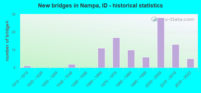
- New bridges - historical statistics
- 11910-1919
- 21940-1949
- 111960-1969
- 171970-1979
- 101980-1989
- 61990-1999
- 282000-2009
- 132010-2019
- 52020-2022

- Reconstructed bridges - Historical Statistics
- 31970-1979
- 11980-1989
- 11990-1999
- 62000-2009


- Bridge Condition - Deck
- 5.3%Excellent
- 3.9%Very good
- 51.3%Good
- 34.2%Satisfactory
- 5.3%Fair

- Bridge Condition - Superstructure
- 3.9%Excellent
- 19.7%Very good
- 34.2%Good
- 34.2%Satisfactory
- 7.9%Fair

- Bridge Condition - Substructure
- 5.3%Excellent
- 31.6%Very good
- 23.7%Good
- 31.6%Satisfactory
- 6.6%Fair
- 1.3%Poor

- Bridge Condition - Channel
- 16.4%Excellent
- 31.1%Very good
- 39.3%Good
- 11.5%Satisfactory
- 1.6%Fair

- Bridge Condition - Culverts
- 50.0%Very good
- 50.0%Good
Find on map >> Show street view
Structure Number: 14729, Location: IN NAMPA (Lat: 43.609750, Lng: -116.596925), Route carried "under" structure: Interstate 84, Year Built: 2006, Structure Length: 0. m, Average Daily Traffic: 75,500 (year 2018), Truck Traffic: 9%, Features Intersected: I 84;KARCHER IC, Facility Carried by Structure: SH 55
Minimum Vertical Clearance: 5.20m (17.06ft), Kilometerpoint: 54.066, Lanes on structure: 4, Lanes under structure: 5, Material/Design: Prestressed concrete, Design/Construction: Stringer/Multi-beam, Length of Maximum Span: 31.7m (104.0ft)
Find on map >> Show street view
Structure Number: 15571, Location: IN NAMPA (Lat: 43.600669, Lng: -116.573608), Route carried "under" structure: City street 8223, Year Built: 2021, Structure Length: 0. m, Average Daily Traffic: 21,000 (year 2021), Truck Traffic: 4%, Features Intersected: NORTHSIDE BLVD IC, Facility Carried by Structure: I 84 EBL WBL
Minimum Vertical Clearance: 5.84m (19.16ft), Kilometerpoint: 2.557, Lanes on structure: 6, Lanes under structure: 8, Material/Design: Steel, Design/Construction: Stringer/Multi-beam, Length of Maximum Span: 67.1m (220.1ft)
Find on map >> Show street view
Structure Number: 15621, Location: AT NAMPA ECL (Lat: 43.599167, Lng: -116.514167), Route carried "under" structure: Business Interstate 84, Year Built: 2011, Structure Length: 0. m, Average Daily Traffic: 27,000 (year 2018), Truck Traffic: 24%, Features Intersected: I 84B ;GARRITY BLVD IC
Minimum Vertical Clearance: 5.18m (16.99ft), Kilometerpoint: 99.343, Lanes on structure: 6, Lanes under structure: 5, Material/Design: Prestressed concrete, Design/Construction: Stringer/Multi-beam, Length of Maximum Span: 39.0m (128.0ft)
Find on map >> Show street view
Structure Number: 19711, Location: 3.2 W. NAMPA WCL (Lat: 43.621500, Lng: -116.613250), Route carried "under" structure: Interstate 84, Year Built: 2021, Structure Length: 0. m, Average Daily Traffic: 60,500 (year 2021), Truck Traffic: 13%, Features Intersected: I 84; MIDDLETON RD. GS, Facility Carried by Structure: NHS 8213;MIDDLETON
Minimum Vertical Clearance: 6.37m (20.90ft), Kilometerpoint: 52.192, Lanes on structure: 2, Lanes under structure: 4, Material/Design: Concrete, Design/Construction: Stringer/Multi-beam, Length of Maximum Span: 34.4m (112.9ft)
Find on map >> Show street view
Structure Number: 21826, Location: IN NAMPA;KARCHER ROAD (Lat: 43.604992, Lng: -116.590542), Route carried "under" structure: Interstate 84, Year Built: 2019, Structure Length: 0. m, Average Daily Traffic: 75,500 (year 2018), Truck Traffic: 9%, Features Intersected: I 84;KARCHER ROAD GS, Facility Carried by Structure: STC 8223;KARCHER R
Minimum Vertical Clearance: 5.89m (19.32ft), Kilometerpoint: 54.821, Lanes on structure: 2, Lanes under structure: 4, Material/Design: Prestressed concrete, Design/Construction: Stringer/Multi-beam, Length of Maximum Span: 41.0m (134.5ft)
Find on map >> Show street view
Structure Number: 21842, Location: IN NAMPA; AMITY AVE (Lat: 43.561417, Lng: -116.533194), Route carried "under" structure: City street , Year Built: 2007, Structure Length: 0. m, Average Daily Traffic: 4,000 (year 2018), Truck Traffic: 8%, Features Intersected: OSRR; AMITY AVE OP, Facility Carried by Structure: STP8423;AMITY AVE
Minimum Vertical Clearance: 5.80m (19.03ft), Kilometerpoint: 3.013, Lanes on structure: 4, Lanes under structure: 2, Material/Design: Steel continuous, Design/Construction: Stringer/Multi-beam, Length of Maximum Span: 74.7m (245.1ft)
Find on map >> Show street view
Structure Number: 21842, Location: IN NAMPA; AMITY AVE (Lat: 43.561417, Lng: -116.533194), Route carried "under" structure: City street , Year Built: 2007, Structure Length: 0. m, Average Daily Traffic: 1,400 (year 2018), Truck Traffic: 30%, Features Intersected: OSRR; AMITY AVE OP, Facility Carried by Structure: STP8423;AMITY AVE
Minimum Vertical Clearance: 6.87m (22.54ft), Kilometerpoint: 12.711, Lanes on structure: 4, Lanes under structure: 2, Material/Design: Steel continuous, Design/Construction: Stringer/Multi-beam, Length of Maximum Span: 74.7m (245.1ft)
Find on map >> Show street view
Structure Number: 21844, Location: IN NAMPA;KINGS RD. (Lat: 43.562583, Lng: -116.534583), Route carried "under" structure: City street , Year Built: 2006, Structure Length: 0. m, Average Daily Traffic: 4,000 (year 2018), Truck Traffic: 8%, Features Intersected: OSRR;KINGS RD OP, Facility Carried by Structure: STC 7819;KINGS RD
Minimum Vertical Clearance: 7.17m (23.52ft), Kilometerpoint: 2.797, Lanes on structure: 4, Lanes under structure: 2, Material/Design: Steel continuous, Design/Construction: Stringer/Multi-beam, Length of Maximum Span: 56.7m (186.0ft)
Find on map >> Show street view
Structure Number: 21844, Location: IN NAMPA;KINGS RD. (Lat: 43.562583, Lng: -116.534583), Route carried "under" structure: City street , Year Built: 2006, Structure Length: 0. m, Average Daily Traffic: 1,400 (year 2018), Truck Traffic: 30%, Features Intersected: OSRR;KINGS RD OP, Facility Carried by Structure: STC 7819;KINGS RD
Minimum Vertical Clearance: 7.73m (25.36ft), Kilometerpoint: 12.398, Lanes on structure: 4, Lanes under structure: 2, Material/Design: Steel continuous, Design/Construction: Stringer/Multi-beam, Length of Maximum Span: 56.7m (186.0ft)
Find on map >> Show street view
Structure Number: 21845, Location: IN NAMPA;16TH AVE (Lat: 43.576333, Lng: -116.555111), Route carried "under" structure: Other road , Year Built: 1969, Structure Length: 0. m, Average Daily Traffic: 1,300 (year 2019), Truck Traffic: 20%, Features Intersected: UPRR;1ST ST N, Facility Carried by Structure: SMA8353;16TH AVE
Minimum Vertical Clearance: 4.14m (13.58ft), Kilometerpoint: 10.140, Lanes on structure: 4, Lanes under structure: 2, Material/Design: Steel, Design/Construction: Stringer/Multi-beam, Length of Maximum Span: 34.1m (111.9ft)
Find on map >> Show street view
Structure Number: 21845, Location: IN NAMPA;16TH AVE (Lat: 43.576333, Lng: -116.555111), Route carried "under" structure: City street , Year Built: 1969, Structure Length: 0. m, Average Daily Traffic: 100 (year 2020), Features Intersected: UPRR;1ST ST N, Facility Carried by Structure: SMA8353;16TH AVE
Minimum Vertical Clearance: 4.27m (14.01ft), Kilometerpoint: 0.117, Lanes on structure: 4, Lanes under structure: 2, Material/Design: Steel, Design/Construction: Stringer/Multi-beam, Length of Maximum Span: 34.1m (111.9ft)
Find on map >> Show street view
Structure Number: 21882, Location: IN NAMPA (Lat: 43.598575, Lng: -116.553144), Route carried "under" structure: Interstate 84, Year Built: 2000, Structure Length: 0. m, Average Daily Traffic: 91,000 (year 2018), Truck Traffic: 8%, Features Intersected: I 84;FRANKLIN BLVD IC, Facility Carried by Structure: STP8393;FRANKLIN B
Minimum Vertical Clearance: 5.66m (18.57ft), Kilometerpoint: 57.935, Lanes on structure: 5, Lanes under structure: 5, Material/Design: Prestressed concrete continuous, Design/Construction: Stringer/Multi-beam, Length of Maximum Span: 23.5m (77.1ft)
Find on map >> Show street view
Structure Number: 21886, Location: IN NAMPA;11th AVE N. (Lat: 43.598000, Lng: -116.537361), Route carried "under" structure: Interstate 84, Year Built: 2010, Structure Length: 0. m, Average Daily Traffic: 91,000 (year 2018), Truck Traffic: 8%, Features Intersected: I 84;11TH AVE N. GS
Minimum Vertical Clearance: 5.61m (18.41ft), Kilometerpoint: 59.230, Lanes on structure: 2, Lanes under structure: 7, Material/Design: Prestressed concrete, Design/Construction: Stringer/Multi-beam, Length of Maximum Span: 35.6m (116.8ft)
Find on map >> Show street view
Structure Number: 27646, Location: 1.5 E. NAMPA ECL (Lat: 43.598917, Lng: -116.493556), Route carried "under" structure: Interstate 84, Year Built: 2009, Structure Length: 0. m, Average Daily Traffic: 106,000 (year 2018), Truck Traffic: 7%, Features Intersected: I 84; ROBINSON RD GS, Facility Carried by Structure: STC 7859;ROBINSON
Minimum Vertical Clearance: 5.49m (18.01ft), Kilometerpoint: 62.759, Lanes on structure: 2, Lanes under structure: 8, Material/Design: Prestressed concrete, Design/Construction: Stringer/Multi-beam, Length of Maximum Span: 29.6m (97.1ft)
Find on map >> Show street view
Structure Number: 27696, Location: IN NAMPA;FRONT ST. (Lat: 43.580278, Lng: -116.560000), Route carried "under" structure: Business Interstate 84, Year Built: 2003, Structure Length: 0. m, Average Daily Traffic: 22,000 (year 2018), Truck Traffic: 5%, Features Intersected: I 84B;NAMPA 11TH AVE UP, Facility Carried by Structure: FRONT STREET
Minimum Vertical Clearance: 5.10m (16.73ft), Kilometerpoint: 94.769, Lanes on structure: 2, Lanes under structure: 4, Material/Design: Prestressed concrete, Design/Construction: Box Beam or Girders - Multiple, Length of Maximum Span: 20.6m (67.6ft)