Bridge Statistics for New Brunswick, New Jersey (NJ)
Condition, Traffic, Stress, Structural Evaluation, Project Costs
- National Bridge Inventory (NBI) Statistics
- 55Number of bridges
- 1,263ft / 385mTotal length
- $5,433,000Total costs
- 1,945,856Total average daily traffic
- 156,348Total average daily truck traffic
- National Bridge Inventory (NBI) Registered Bridges for New Brunswick
- No street view available for this location
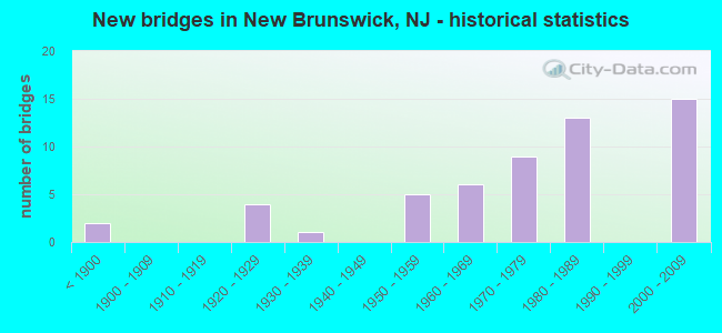
- New bridges - historical statistics
- 2Before 1900
- 41920-1929
- 11930-1939
- 51950-1959
- 61960-1969
- 91970-1979
- 131980-1989
- 152000-2009

- Reconstructed bridges - Historical Statistics
- 21960-1969
- 11970-1979
- 21980-1989
- 21990-1999
- 02000-2009
- 22010-2019


- Bridge Condition - Deck
- 3.2%Very good
- 58.1%Good
- 29.0%Satisfactory
- 6.5%Fair
- 3.2%Poor

- Bridge Condition - Superstructure
- 27.3%Very good
- 21.2%Good
- 33.3%Satisfactory
- 15.2%Fair
- 3.0%Serious

- Bridge Condition - Substructure
- 9.1%Very good
- 33.3%Good
- 39.4%Satisfactory
- 12.1%Fair
- 6.1%Poor

- Bridge Condition - Channel
- 10.5%Excellent
- 26.3%Very good
- 52.6%Good
- 10.5%Satisfactory
Find on map >> Show street view
Structure Number: 1229152, Location: NJ 172 & NJ 18 JCT. (Lat: 40.486681, Lng: -74.432581), Route carried "under" structure: State highway 18, Year Built: 2009, Structure Length: 0. m, Average Daily Traffic: 72,754 (year 2021), Truck Traffic: 4%, Features Intersected: NJ 18, Facility Carried by Structure: NJ 172
Minimum Vertical Clearance: 5.05m (16.57ft), Kilometerpoint: 66.643, Lanes on structure: 3, Lanes under structure: 5, Material/Design: Steel, Design/Construction: Stringer/Multi-beam, Length of Maximum Span: 32.3m (106.0ft)
Find on map >> Show street view
Structure Number: 123715, Location: 1.7 MI NORTH OF US 1 (Lat: 40.497150, Lng: -74.439781), Route carried "under" structure: State highway 27, Year Built: 2007, Structure Length: 0. m, Average Daily Traffic: 18,650 (year 2020), Truck Traffic: 4%, Features Intersected: ALBANY ST (NJ 27), Facility Carried by Structure: NJ 18 (MEMRL PKWY)
Minimum Vertical Clearance: 5.21m (17.09ft), Kilometerpoint: 26.635, Lanes on structure: 7, Lanes under structure: 4, Material/Design: Steel, Design/Construction: Stringer/Multi-beam, Length of Maximum Span: 28.7m (94.2ft)
Find on map >> Show street view
Structure Number: 1237152, Location: 2.3 MILES NORTH OF US 1 (Lat: 40.503711, Lng: -74.446881), Route carried "under" structure: State highway 18, Year Built: 1982, Structure Length: 0. m, Average Daily Traffic: 69,674 (year 2020), Truck Traffic: 5%, Features Intersected: ROUTE NJ-18
Minimum Vertical Clearance: 7.26m (23.82ft), Kilometerpoint: 69.025, Lanes on structure: 1, Lanes under structure: 4, Material/Design: Steel, Design/Construction: Stringer/Multi-beam, Length of Maximum Span: 32.0m (105.0ft)
Find on map >> Show street view
Structure Number: 1237153, Location: 1 MI N OF RT 27 JCT (Lat: 40.506131, Lng: -74.451819), Route carried "under" structure: State highway 18, Year Built: 1982, Structure Length: 0. m, Average Daily Traffic: 39,772 (year 2020), Truck Traffic: 5%, Features Intersected: NJ RT 18 AND RAMP GS
Minimum Vertical Clearance: 7.37m (24.18ft), Kilometerpoint: 69.491, Lanes on structure: 1, Lanes under structure: 4, Material/Design: Steel, Design/Construction: Stringer/Multi-beam, Length of Maximum Span: 22.3m (73.2ft)
Find on map >> Show street view
Structure Number: 1237153, Location: 1 MI N OF RT 27 JCT (Lat: 40.506131, Lng: -74.451819), Route carried "under" structure: Ramp State highway 18, Year Built: 1982, Structure Length: 0. m, Average Daily Traffic: 2,868 (year 2020), Truck Traffic: 5%, Features Intersected: NJ RT 18 AND RAMP GS
Minimum Vertical Clearance: 6.65m (21.82ft), Kilometerpoint: 69.491, Lanes on structure: 1, Lanes under structure: 1, Material/Design: Steel, Design/Construction: Stringer/Multi-beam, Length of Maximum Span: 22.3m (73.2ft)
Find on map >> Show street view
Structure Number: 1237154, Location: 2.7 MILES NORTH OF US 1 (Lat: 40.506311, Lng: -74.453661), Route carried "under" structure: Ramp State highway 18, Year Built: 1982, Structure Length: 0. m, Average Daily Traffic: 1,977 (year 2020), Truck Traffic: 4%, Features Intersected: RAMPG(18SBTOCR672)
Minimum Vertical Clearance: 4.70m (15.42ft), Kilometerpoint: 69.524, Lanes on structure: 1, Lanes under structure: 1, Material/Design: Steel, Design/Construction: Stringer/Multi-beam, Length of Maximum Span: 24.7m (81.0ft)
Find on map >> Show street view
Structure Number: 1237155, Location: 1.13MI W OF NJ18&27 JCT (Lat: 40.507311, Lng: -74.456961), Route carried "under" structure: City street , Year Built: 1980, Structure Length: 0. m, Average Daily Traffic: 224 (year 2020), Truck Traffic: 1%, Features Intersected: RARITAN R,JOHNSON,GEORGE, Facility Carried by Structure: NJ 18
Minimum Vertical Clearance: 7.09m (23.26ft), Kilometerpoint: 0.000, Lanes on structure: 5, Lanes under structure: 2, Material/Design: Steel continuous, Design/Construction: Girder and Floorbeam System, Length of Maximum Span: 74.7m (245.1ft)
Find on map >> Show street view
Structure Number: 1237155, Location: 1.13MI W OF NJ18&27 JCT (Lat: 40.507311, Lng: -74.456961), Route carried "under" structure: Ramp State highway 18, Year Built: 1980, Structure Length: 0. m, Average Daily Traffic: 541 (year 2020), Truck Traffic: 4%, Features Intersected: RARITAN R,JOHNSON,GEORGE
Minimum Vertical Clearance: 4.90m (16.08ft), Kilometerpoint: 70.006, Lanes on structure: 5, Lanes under structure: 1, Material/Design: Steel continuous, Design/Construction: Girder and Floorbeam System, Length of Maximum Span: 74.7m (245.1ft)
Find on map >> Show street view
Structure Number: 1237158, Location: 1.53 MI N OF NJ 27 JCT (Lat: 40.511681, Lng: -74.458861), Route carried "under" structure: County highway 609, Year Built: 2004, Structure Length: 0. m, Average Daily Traffic: 7,168 (year 2021), Truck Traffic: 4%, Features Intersected: RIVER RD, BRK&BIKE PATH, Facility Carried by Structure: NJ 18 NB & RAMP A
Minimum Vertical Clearance: 5.18m (16.99ft), Kilometerpoint: 2.655, Lanes on structure: 2, Lanes under structure: 4, Material/Design: Steel continuous, Design/Construction: Stringer/Multi-beam, Length of Maximum Span: 49.1m (161.1ft)
Find on map >> Show street view
Structure Number: 1237159, Location: 1.5 mi from Rt NJ 27 (Lat: 40.512081, Lng: -74.458669), Route carried "under" structure: County highway 609, Year Built: 2005, Structure Length: 0. m, Average Daily Traffic: 459 (year 2021), Truck Traffic: 4%, Features Intersected: RIVER ROAD(CR.609), Facility Carried by Structure: NJ 18
Minimum Vertical Clearance: 4.98m (16.34ft), Kilometerpoint: 1.191, Lanes on structure: 2, Lanes under structure: 4, Material/Design: Steel continuous, Design/Construction: Stringer/Multi-beam, Length of Maximum Span: 44.8m (147.0ft)
Find on map >> Show street view
Structure Number: M08372, Location: .1 MI N INTERCHANGE 9 (Lat: 40.482083, Lng: -74.403097), Route carried "under" structure: Interstate 95, Year Built: 1973, Structure Length: 0. m, Average Daily Traffic: 55,580 (year 2021), Truck Traffic: 18%, Features Intersected: NJTPK(I-95) NSO ROADWAY, Facility Carried by Structure: NJTPK INT9 RAMPNIT
Minimum Vertical Clearance: 4.70m (15.42ft), Kilometerpoint: 61.799, Lanes on structure: 1, Lanes under structure: 3, Toll: On toll road, Material/Design: Steel, Design/Construction: Stringer/Multi-beam, Length of Maximum Span: 32.9m (107.9ft)
Find on map >> Show street view
Structure Number: M08424N, Location: .7 MI N OF INT 9 (Lat: 40.488333, Lng: -74.396667), Route carried "under" structure: Ramp Other road 95, Year Built: 1973, Structure Length: 0. m, Average Daily Traffic: 107 (year 2020), Truck Traffic: 1%, Features Intersected: RARITAN RIVER&NJTPK UTRN, Facility Carried by Structure: NJTPK SNO-SNI RWYS
Minimum Vertical Clearance: 9.45m (31.00ft), Kilometerpoint: 62.233, Lanes on structure: 6, Lanes under structure: 2, Toll: On toll road, Material/Design: Steel continuous, Design/Construction: Girder and Floorbeam System, Length of Maximum Span: 64.9m (212.9ft)
Find on map >> Show street view
Structure Number: M08424S, Location: .7 MI N INT 9 (Lat: 40.488333, Lng: -74.396667), Route carried "under" structure: Ramp Other road 95, Year Built: 1952, Structure Length: 0. m, Average Daily Traffic: 107 (year 2020), Truck Traffic: 1%, Features Intersected: RARITAN RIVER & NJTP, Facility Carried by Structure: NJ TP NSO-NSI RWYS
Minimum Vertical Clearance: 9.35m (30.68ft), Kilometerpoint: 62.233, Lanes on structure: 6, Lanes under structure: 2, Toll: On toll road, Material/Design: Steel continuous, Design/Construction: Girder and Floorbeam System, Length of Maximum Span: 64.9m (212.9ft)