Bridge Statistics for New Haven, Michigan (MI)
Condition, Traffic, Stress, Structural Evaluation, Project Costs
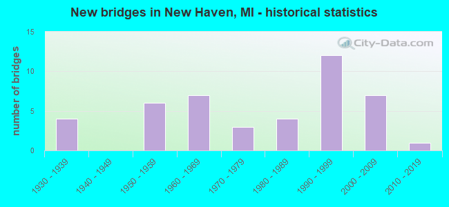
- New bridges - historical statistics
- 41930-1939
- 61950-1959
- 71960-1969
- 31970-1979
- 41980-1989
- 121990-1999
- 72000-2009
- 12010-2019
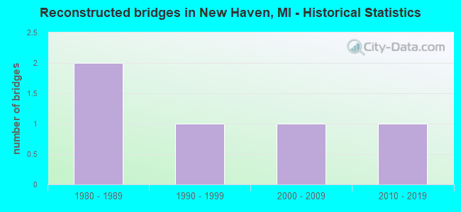
- Reconstructed bridges - Historical Statistics
- 21980-1989
- 11990-1999
- 12000-2009
- 12010-2019
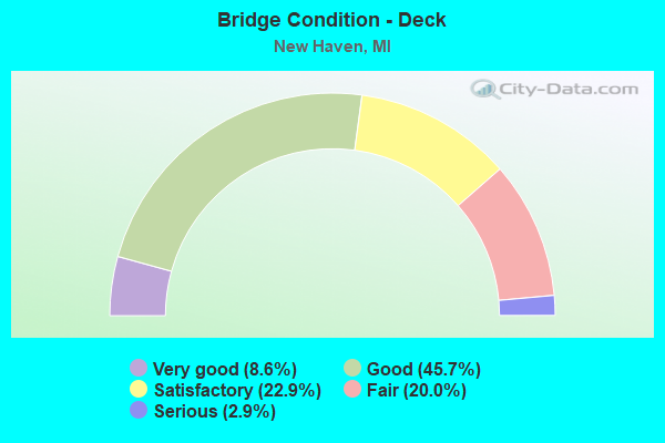
- Bridge Condition - Deck
- 8.6%Very good
- 45.7%Good
- 22.9%Satisfactory
- 20.0%Fair
- 2.9%Serious
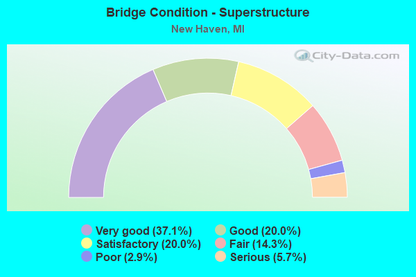
- Bridge Condition - Superstructure
- 37.1%Very good
- 20.0%Good
- 20.0%Satisfactory
- 14.3%Fair
- 2.9%Poor
- 5.7%Serious
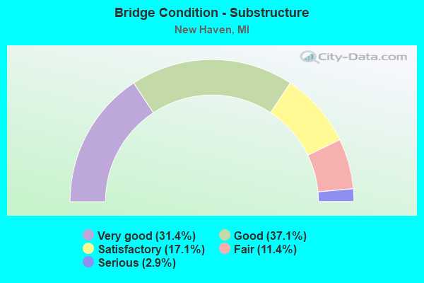
- Bridge Condition - Substructure
- 31.4%Very good
- 37.1%Good
- 17.1%Satisfactory
- 11.4%Fair
- 2.9%Serious
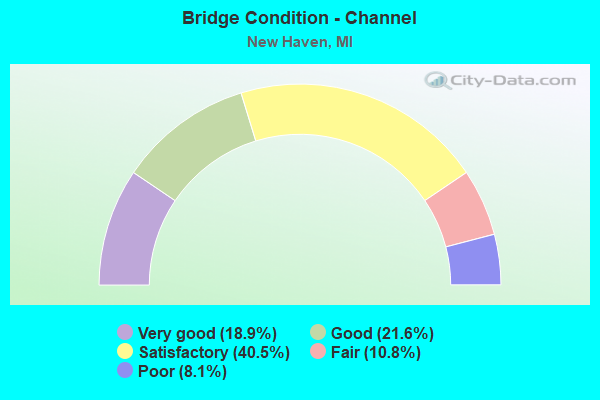
- Bridge Condition - Channel
- 18.9%Very good
- 21.6%Good
- 40.5%Satisfactory
- 10.8%Fair
- 8.1%Poor
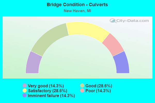
- Bridge Condition - Culverts
- 14.3%Very good
- 28.6%Good
- 28.6%Satisfactory
- 14.3%Poor
- 14.3%Imminent failure
Find on map >> Show street view
Structure Number: 855, Location: 8.6 MI E OF I-196 (Lat: 42.183403, Lng: -86.223011), Route carried "on" structure: County highway , Year Built: 1960, Status: Open, Structure Length: 7.19m (23.59ft), Average Daily Traffic: 265 (year 1984), Truck Traffic: 3%, Average Future Daily Traffic: 300 (year 2014), Design Load: H 15, Features Intersected: I-94, Facility Carried by Structure: COUNTY LINE ROAD
Minimum Vertical Clearance: 30.48m (100.00ft), Kilometerpoint: 12.431, Lanes on structure: 2, Lanes under structure: 4, Owner: State Highway Agency, Approaching Roadway Width: 7.9m (25.9ft), Skew: 1 degrees, Material/Design: Concrete continuous, Design/Construction: Tee Beam, Number Of Spans In Main Unit: 4, Length of Maximum Span: 22.4m (73.5ft), Curb-To-Curb Width: 7.9m (25.9ft), Out-to-Out Width: 10.2m (33.5ft)
Condition: Deck: Good, Superstructure: Satisfactory, Substructure: Satisfactory, Operating Rating: 55.1 metric tons, Method Used To Determine Operating Rating: Load Factor (LF) rating reported by rating factor (RF) method using MS18 loading, Inventory Rating: 34.0 metric tons, Method Used To Determine Inventory Rating: Load Factor (LF) rating reported by rating factor (RF) method using MS18 loading, Structural Evaluation: Equal to present minimum criteria, Deck Geometry: Somewhat better than minimum adequacy, Underclear: Meets minimum limits, Approach Roadway Alignment: Equal to present minimum criteria, Length Of Structure Improvement: 7.20m (23.62ft), Designated Inspection Frequency: Every 24 months, Inspection Date: June 2020, Bridge Improvement Cost: $83,000, Roadway Improvement Cost: $8,000, Total Project Cost: $97,000, Deck Structure Type: Concrete Cast-file-Place, Wearing Surface/Protective System: Wearing Surface: Latex Concrete
Find on map >> Show street view
Structure Number: 1036, Location: 1 MI N OF GALIEN (Lat: 41.814242, Lng: -86.498939), Route carried "on" structure: County highway , Year Built: 1930, Year Reconstructed: 2004, Status: Posted for load, Structure Length: 0.91m (2.99ft), Average Daily Traffic: 36 (year 2007), Average Future Daily Traffic: 50 (year 2027), Design Load: HS 20+Mod, Features Intersected: GALIEN RIVER, Facility Carried by Structure: HESS ROAD
Minimum Vertical Clearance: 30.48m (100.00ft), Kilometerpoint: 0.414, Lanes on structure: 1, Owner: County Highway Agency, Approaching Roadway Width: 6.1m (20.0ft), Skew: 1 degrees, Material/Design: Wood or Timber, Design/Construction: Slab, Number Of Spans In Main Unit: 1, Length of Maximum Span: 8.5m (27.9ft), Curb-To-Curb Width: 6.7m (22.0ft), Out-to-Out Width: 7.1m (23.3ft)
Condition: Deck: Good, Superstructure: Good, Substructure: Serious, Channel: Poor, Operating Rating: 27.1 metric tons, Method Used To Determine Operating Rating: Field evaluation and documented engineering judgment, Inventory Rating: 20.2 metric tons, Method Used To Determine Inventory Rating: Field evaluation and documented engineering judgment, Structural Evaluation: High priority of corrective action, Deck Geometry: Somewhat better than minimum adequacy, Waterway Adequacy: Equal to present desirable criteria, Approach Roadway Alignment: Equal to present desirable criteria, Bridge Posting: Required (Relationship of Operating Rating to Maximum Legal Load: > 39.9% below), Length Of Structure Improvement: 0.76m (2.49ft), Designated Inspection Frequency: Every 12 months, Inspection Date: April 2021, Bridge Improvement Cost: $150,000, Roadway Improvement Cost: $10,000, Total Project Cost: $160,000, Deck Structure Type: Wood or Timber, Wearing Surface/Protective System: Wearing Surface: Bituminous
Find on map >> Show street view
Structure Number: 2802, Location: 0.1 MI. WEST OF FENTON RD (Lat: 42.900544, Lng: -83.691814), Route carried "on" structure: County highway , Year Built: 1930, Status: Posted for load, Structure Length: 0.94m (3.08ft), Average Daily Traffic: 542 (year 2009), Truck Traffic: 2%, Average Future Daily Traffic: 979 (year 2029), Design Load: HS 20+Mod, Features Intersected: SWARTZ CREEK, Facility Carried by Structure: COOK ROAD
Minimum Vertical Clearance: 30.48m (100.00ft), Kilometerpoint: 3.117, Lanes on structure: 2, Owner: County Highway Agency, Approaching Roadway Width: 11.0m (36.1ft), Material/Design: Concrete, Design/Construction: Tee Beam, Number Of Spans In Main Unit: 1, Length of Maximum Span: 8.8m (28.9ft), Curb-To-Curb Width: 11.0m (36.1ft), Out-to-Out Width: 11.5m (37.7ft)
Condition: Deck: Fair, Superstructure: Serious, Substructure: Satisfactory, Channel: Satisfactory, Operating Rating: 34.0 metric tons, Method Used To Determine Operating Rating: Load Factor (LF) rating reported by rating factor (RF) method using MS18 loading, Inventory Rating: 20.4 metric tons, Method Used To Determine Inventory Rating: Load Factor (LF) rating reported by rating factor (RF) method using MS18 loading, Structural Evaluation: High priority of corrective action, Deck Geometry: Better than present minimum criteria, Waterway Adequacy: Equal to present minimum criteria, Approach Roadway Alignment: Equal to present desirable criteria, Bridge Posting: Required (Relationship of Operating Rating to Maximum Legal Load: 20.0 - 29.9% below), Designated Inspection Frequency: Every 12 months, Inspection Date: October 2021, Deck Structure Type: Concrete Cast-file-Place, Wearing Surface/Protective System: Wearing Surface: Bituminous
Find on map >> Show street view
Structure Number: 6134, Location: 1.5 MI W OF I-94 (Lat: 42.723975, Lng: -82.793558), Route carried "on" structure: State highway 19, Year Built: 1985, Status: Open, Structure Length: 0.73m (2.40ft), Average Daily Traffic: 13,180 (year 2007), Truck Traffic: 4%, Average Future Daily Traffic: 12,639 (year 2018), Design Load: HS 25 or greater, Features Intersected: S BR SALT RIVER
Minimum Vertical Clearance: 30.48m (100.00ft), Kilometerpoint: 15.223, Lanes on structure: 3, Base Highway Network: Yes (Inventory Route: 83, Subroute: 10), Owner: State Highway Agency, Approaching Roadway Width: 16.8m (55.1ft), Skew: 1 degrees, Material/Design: Prestressed concrete, Design/Construction: Box Beam or Girders - Multiple, Number Of Spans In Main Unit: 1, Length of Maximum Span: 7.3m (24.0ft), Curb-To-Curb Width: 17.1m (56.1ft), Out-to-Out Width: 18.1m (59.4ft)
Condition: Deck: Fair, Superstructure: Good, Substructure: Good, Channel: Good, Operating Rating: 59.0 metric tons, Method Used To Determine Operating Rating: Load Factor (LF) rating reported by rating factor (RF) method using MS18 loading, Inventory Rating: 35.3 metric tons, Method Used To Determine Inventory Rating: Load Factor (LF) rating reported by rating factor (RF) method using MS18 loading, Structural Evaluation: Better than present minimum criteria, Deck Geometry: Superior to present desirable criteria, Waterway Adequacy: Better than present minimum criteria, Approach Roadway Alignment: Equal to present minimum criteria, Designated Inspection Frequency: Every 24 months, Inspection Date: April 2020, Deck Structure Type: Concrete Cast-file-Place, Wearing Surface/Protective System: Wearing Surface: Monolithic Concrete, Deck Protection: Epoxy Coated Reinforcing
Find on map >> Show street view
Structure Number: 6135, Location: 5.2 MI SW OF ST CLAIR COL (Lat: 42.730425, Lng: -82.788133), Route carried "on" structure: State highway 19, Year Built: 1991, Status: Open, Structure Length: 1.37m (4.49ft), Average Daily Traffic: 13,180 (year 2007), Truck Traffic: 4%, Average Future Daily Traffic: 12,639 (year 2018), Design Load: HS 25 or greater, Features Intersected: SALT RIVER
Minimum Vertical Clearance: 30.48m (100.00ft), Kilometerpoint: 16.067, Lanes on structure: 2, Base Highway Network: Yes (Inventory Route: 83, Subroute: 10), Owner: State Highway Agency, Approaching Roadway Width: 14.6m (47.9ft), Material/Design: Prestressed concrete, Design/Construction: Box Beam or Girders - Multiple, Number Of Spans In Main Unit: 1, Length of Maximum Span: 13.7m (44.9ft), Curb-To-Curb Width: 14.6m (47.9ft), Out-to-Out Width: 15.6m (51.2ft)
Condition: Deck: Satisfactory, Superstructure: Satisfactory, Substructure: Satisfactory, Channel: Satisfactory, Operating Rating: 70.6 metric tons, Method Used To Determine Operating Rating: Load Factor (LF) rating reported by rating factor (RF) method using MS18 loading, Inventory Rating: 42.1 metric tons, Method Used To Determine Inventory Rating: Load Factor (LF) rating reported by rating factor (RF) method using MS18 loading, Structural Evaluation: Equal to present minimum criteria, Deck Geometry: Superior to present desirable criteria, Waterway Adequacy: Equal to present desirable criteria, Approach Roadway Alignment: Equal to present minimum criteria, Designated Inspection Frequency: Every 24 months, Inspection Date: April 2020, Bridge Improvement Cost: $96,000, Deck Structure Type: Concrete Cast-file-Place, Wearing Surface/Protective System: Wearing Surface: Monolithic Concrete, Deck Protection: Epoxy Coated Reinforcing
Find on map >> Show street view
Structure Number: 6136, Location: 3.3 MI SW OF ST CLAIR COL (Lat: 42.752636, Lng: -82.770047), Route carried "on" structure: State highway 19, Year Built: 1991, Status: Open, Structure Length: 1.06m (3.48ft), Average Daily Traffic: 12,497 (year 2007), Truck Traffic: 2%, Average Future Daily Traffic: 23,880 (year 2018), Design Load: HS 25 or greater, Features Intersected: SALT RIVER
Minimum Vertical Clearance: 30.48m (100.00ft), Kilometerpoint: 18.944, Lanes on structure: 2, Base Highway Network: Yes (Inventory Route: 83, Subroute: 10), Owner: State Highway Agency, Approaching Roadway Width: 14.6m (47.9ft), Material/Design: Prestressed concrete, Design/Construction: Box Beam or Girders - Multiple, Number Of Spans In Main Unit: 1, Length of Maximum Span: 10.6m (34.8ft), Curb-To-Curb Width: 14.6m (47.9ft), Out-to-Out Width: 15.6m (51.2ft)
Condition: Deck: Good, Superstructure: Satisfactory, Substructure: Good, Channel: Satisfactory, Operating Rating: 82.6 metric tons, Method Used To Determine Operating Rating: Load Factor (LF) rating reported by rating factor (RF) method using MS18 loading, Inventory Rating: 49.6 metric tons, Method Used To Determine Inventory Rating: Load Factor (LF) rating reported by rating factor (RF) method using MS18 loading, Structural Evaluation: Equal to present minimum criteria, Deck Geometry: Superior to present desirable criteria, Waterway Adequacy: Equal to present desirable criteria, Approach Roadway Alignment: Equal to present minimum criteria, Designated Inspection Frequency: Every 24 months, Inspection Date: April 2020, Bridge Improvement Cost: $75,000, Deck Structure Type: Concrete Cast-file-Place, Wearing Surface/Protective System: Wearing Surface: Bituminous, Deck Protection: Epoxy Coated Reinforcing
Find on map >> Show street view
Structure Number: 6137, Location: 2.7 MI SW OF ST CLAIR COL (Lat: 42.759492, Lng: -82.764564), Route carried "on" structure: State highway 19, Year Built: 1991, Status: Open, Structure Length: 1.06m (3.48ft), Average Daily Traffic: 12,497 (year 2007), Truck Traffic: 2%, Average Future Daily Traffic: 23,880 (year 2018), Design Load: HS 25 or greater, Features Intersected: SALT RIVER
Minimum Vertical Clearance: 30.48m (100.00ft), Kilometerpoint: 19.828, Lanes on structure: 2, Base Highway Network: Yes (Inventory Route: 83, Subroute: 10), Owner: State Highway Agency, Approaching Roadway Width: 14.6m (47.9ft), Material/Design: Prestressed concrete, Design/Construction: Box Beam or Girders - Multiple, Number Of Spans In Main Unit: 1, Length of Maximum Span: 10.6m (34.8ft), Curb-To-Curb Width: 14.6m (47.9ft), Out-to-Out Width: 15.6m (51.2ft)
Condition: Deck: Satisfactory, Superstructure: Good, Substructure: Good, Channel: Good, Operating Rating: 82.6 metric tons, Method Used To Determine Operating Rating: Load Factor (LF) rating reported by rating factor (RF) method using MS18 loading, Inventory Rating: 49.6 metric tons, Method Used To Determine Inventory Rating: Load Factor (LF) rating reported by rating factor (RF) method using MS18 loading, Structural Evaluation: Better than present minimum criteria, Deck Geometry: Superior to present desirable criteria, Waterway Adequacy: Equal to present desirable criteria, Approach Roadway Alignment: Equal to present minimum criteria, Designated Inspection Frequency: Every 24 months, Inspection Date: April 2020, Bridge Improvement Cost: $75,000, Deck Structure Type: Concrete Cast-file-Place, Wearing Surface/Protective System: Wearing Surface: Bituminous, Deck Protection: Epoxy Coated Reinforcing
Find on map >> Show street view
Structure Number: 6176, Location: 1.0 MI S OF M-29 (Lat: 42.663639, Lng: -82.829225), Route carried "on" structure: County highway 2058, Year Built: 1963, Year Reconstructed: 2006, Status: Open, Structure Length: 7.91m (25.95ft), Average Daily Traffic: 4,369 (year 1996), Truck Traffic: 3%, Average Future Daily Traffic: 5,024 (year 2016), Design Load: H 20, Features Intersected: I-94, Facility Carried by Structure: COTTON RD
Minimum Vertical Clearance: 30.48m (100.00ft), Kilometerpoint: 2.528, Lanes on structure: 2, Lanes under structure: 6, Owner: State Highway Agency, Approaching Roadway Width: 12.5m (41.0ft), Material/Design: Steel, Design/Construction: Stringer/Multi-beam, Number Of Spans In Main Unit: 4, Length of Maximum Span: 25.9m (85.0ft), Curb-To-Curb Width: 9.1m (29.9ft), Out-to-Out Width: 10.2m (33.5ft)
Condition: Deck: Fair, Superstructure: Satisfactory, Substructure: Good, Operating Rating: 69.7 metric tons, Method Used To Determine Operating Rating: Load Factor (LF) rating reported by rating factor (RF) method using MS18 loading, Inventory Rating: 41.8 metric tons, Method Used To Determine Inventory Rating: Load Factor (LF) rating reported by rating factor (RF) method using MS18 loading, Structural Evaluation: Equal to present minimum criteria, Deck Geometry: Meets minimum limits, Underclear: Meets minimum limits, Approach Roadway Alignment: Better than present minimum criteria, Designated Inspection Frequency: Every 24 months, Inspection Date: June 2021, Deck Structure Type: Concrete Cast-file-Place, Wearing Surface/Protective System: Wearing Surface: Latex Concrete
Find on map >> Show street view
Structure Number: 6182, Location: @ M-3 & M-29 (Lat: 42.674361, Lng: -82.820375), Route carried "on" structure: State highway 3, Year Built: 1963, Status: Open, Structure Length: 10.61m (34.81ft), Average Daily Traffic: 37,832 (year 2007), Truck Traffic: 1%, Average Future Daily Traffic: 52,819 (year 2018), Design Load: HS 20, Features Intersected: I-94
Minimum Vertical Clearance: 30.48m (100.00ft), Kilometerpoint: 22.715, Lanes on structure: 4, Lanes under structure: 6, Base Highway Network: Yes (Inventory Route: 80, Subroute: 6), Owner: State Highway Agency, Approaching Roadway Width: 27.7m (90.9ft), Skew: 24 degrees, Material/Design: Steel, Design/Construction: Stringer/Multi-beam, Number Of Spans In Main Unit: 4, Length of Maximum Span: 36.8m (120.7ft), Curb or Sidewalk Widths: Left: 0.7m (2.3ft), Right: 0.7m (2.3ft), Curb-To-Curb Width: 20.7m (67.9ft), Out-to-Out Width: 22.9m (75.1ft)
Condition: Deck: Satisfactory, Superstructure: Poor, Substructure: Good, Operating Rating: 80.0 metric tons, Method Used To Determine Operating Rating: Load Factor (LF) rating reported by rating factor (RF) method using MS18 loading, Inventory Rating: 48.0 metric tons, Method Used To Determine Inventory Rating: Load Factor (LF) rating reported by rating factor (RF) method using MS18 loading, Structural Evaluation: Meets minimum limits, Deck Geometry: Superior to present desirable criteria, Underclear: High priority of corrective action, Approach Roadway Alignment: Better than present minimum criteria, Designated Inspection Frequency: Every 12 months, Inspection Date: June 2021, Deck Structure Type: Concrete Cast-file-Place, Wearing Surface/Protective System: Wearing Surface: Integral Concrete
Find on map >> Show street view
Structure Number: 6226, Location: 0.3 MI W OF GRATIOT US-25 (Lat: 42.764614, Lng: -82.765683), Route carried "on" structure: County highway , Year Built: 1987, Status: Open, Structure Length: 0.97m (3.18ft), Average Daily Traffic: 150 (year 2019), Truck Traffic: 2%, Average Future Daily Traffic: 200 (year 2039), Design Load: HS 25 or greater, Features Intersected: SALT RIVER, Facility Carried by Structure: 29 MILE ROAD
Minimum Vertical Clearance: 30.48m (100.00ft), Kilometerpoint: 23.949, Lanes on structure: 2, Owner: County Highway Agency, Approaching Roadway Width: 12.0m (39.4ft), Material/Design: Prestressed concrete, Design/Construction: Stringer/Multi-beam, Number Of Spans In Main Unit: 1, Length of Maximum Span: 9.1m (29.9ft), Curb-To-Curb Width: 12.0m (39.4ft), Out-to-Out Width: 13.2m (43.3ft)
Condition: Deck: Good, Superstructure: Very good, Substructure: Fair, Channel: Satisfactory, Operating Rating: 74.5 metric tons, Method Used To Determine Operating Rating: Load Factor (LF) rating reported by rating factor (RF) method using MS18 loading, Inventory Rating: 44.7 metric tons, Method Used To Determine Inventory Rating: Load Factor (LF) rating reported by rating factor (RF) method using MS18 loading, Structural Evaluation: Somewhat better than minimum adequacy, Deck Geometry: Superior to present desirable criteria, Waterway Adequacy: Superior to present desirable criteria, Approach Roadway Alignment: Equal to present desirable criteria, Designated Inspection Frequency: Every 24 months, Inspection Date: November 2021, Deck Structure Type: Concrete Cast-file-Place, Wearing Surface/Protective System: Wearing Surface: Monolithic Concrete, Deck Protection: Epoxy Coated Reinforcing
Find on map >> Show street view
Structure Number: 6278, Location: 0.1 MILE EAST OF PLACE RD (Lat: 42.744742, Lng: -82.830939), Route carried "on" structure: County highway 5068, Year Built: 2014, Status: Open, Structure Length: 1.98m (6.50ft), Average Daily Traffic: 2,870 (year 2013), Truck Traffic: 5%, Average Future Daily Traffic: 4,616 (year 2033), Design Load: Greater than HL93, Features Intersected: DEER CREEK, Facility Carried by Structure: NEW HAVEN RD
Minimum Vertical Clearance: 30.48m (100.00ft), Kilometerpoint: 10.860, Lanes on structure: 2, Owner: County Highway Agency, Approaching Roadway Width: 12.2m (40.0ft), Skew: 1 degrees, Material/Design: Prestressed concrete, Design/Construction: Box Beam or Girders - Single/Spread, Number Of Spans In Main Unit: 1, Length of Maximum Span: 19.4m (63.6ft), Curb-To-Curb Width: 12.2m (40.0ft), Out-to-Out Width: 12.9m (42.3ft)
Condition: Deck: Good, Superstructure: Very good, Substructure: Very good, Channel: Good, Operating Rating: 64.2 metric tons, Method Used To Determine Operating Rating: Load and Resistance Factor Rating (LRFR) rating reported by rating factor(RF) method using HL-93 loadings, Inventory Rating: 49.6 metric tons, Method Used To Determine Inventory Rating: Load and Resistance Factor Rating (LRFR) rating reported by rating factor(RF) method using HL-93 loadings, Structural Evaluation: Equal to present desirable criteria, Deck Geometry: Equal to present minimum criteria, Waterway Adequacy: Superior to present desirable criteria, Approach Roadway Alignment: Equal to present desirable criteria, Designated Inspection Frequency: Every 24 months, Inspection Date: July 2020, Deck Structure Type: Concrete Cast-file-Place, Wearing Surface/Protective System: Wearing Surface: Monolithic Concrete, Deck Protection: Epoxy Coated Reinforcing
Find on map >> Show street view
Structure Number: 6279, Location: 0.1 MILE WEST OF 28 MILE (Lat: 42.748933, Lng: -82.842733), Route carried "on" structure: County highway 5068, Year Built: 1954, Status: Posted for load, Structure Length: 1.98m (6.50ft), Average Daily Traffic: 3,200 (year 2019), Truck Traffic: 5%, Average Future Daily Traffic: 4,300 (year 2039), Design Load: H 15, Features Intersected: E B COON CREEK, Facility Carried by Structure: NEW HAVEN RD
Minimum Vertical Clearance: 30.48m (100.00ft), Kilometerpoint: 11.934, Lanes on structure: 2, Owner: County Highway Agency, Approaching Roadway Width: 13.1m (43.0ft), Material/Design: Steel, Design/Construction: Stringer/Multi-beam, Number Of Spans In Main Unit: 1, Length of Maximum Span: 19.2m (63.0ft), Curb or Sidewalk Widths: Left: 0.2m (0.7ft), Right: 0.2m (0.7ft), Curb-To-Curb Width: 7.3m (24.0ft), Out-to-Out Width: 8.5m (27.9ft)
Condition: Deck: Serious, Superstructure: Serious, Substructure: Satisfactory, Channel: Satisfactory, Operating Rating: 21.1 metric tons, Method Used To Determine Operating Rating: Load Factor (LF) rating reported by rating factor (RF) method using MS18 loading, Inventory Rating: 12.6 metric tons, Method Used To Determine Inventory Rating: Load Factor (LF) rating reported by rating factor (RF) method using MS18 loading, Structural Evaluation: High priority of corrective action, Deck Geometry: High priority of replacement, Waterway Adequacy: Somewhat better than minimum adequacy, Approach Roadway Alignment: Equal to present desirable criteria, Bridge Posting: Required (Relationship of Operating Rating to Maximum Legal Load: > 39.9% below), Designated Inspection Frequency: Every 12 months, Inspection Date: September 2021, Deck Structure Type: Concrete Cast-file-Place, Wearing Surface/Protective System: Wearing Surface: Bituminous
Find on map >> Show street view
Structure Number: 628, Location: 0.7 MI EAST OF NORTH AVE (Lat: 42.758117, Lng: -82.870289), Route carried "on" structure: County highway 5068, Year Built: 1974, Status: Open, Structure Length: 0.94m (3.08ft), Average Daily Traffic: 2,900 (year 2009), Truck Traffic: 5%, Average Future Daily Traffic: 4,309 (year 2029), Design Load: H 20, Features Intersected: COON CREEK, Facility Carried by Structure: NEW HAVEN RD
Minimum Vertical Clearance: 30.48m (100.00ft), Kilometerpoint: 14.409, Lanes on structure: 2, Owner: County Highway Agency, Approaching Roadway Width: 12.0m (39.4ft), Material/Design: Steel, Design/Construction: Culvert, Number Of Spans In Main Unit: 2, Length of Maximum Span: 4.2m (13.8ft)
Condition: Channel: Fair, Culverts: Satisfactory, Operating Rating: 97.2 metric tons, Method Used To Determine Operating Rating: Load Factor (LF) rating reported by rating factor (RF) method using MS18 loading, Inventory Rating: 97.2 metric tons, Method Used To Determine Inventory Rating: Load Factor (LF) rating reported by rating factor (RF) method using MS18 loading, Structural Evaluation: Equal to present minimum criteria, Waterway Adequacy: Somewhat better than minimum adequacy, Approach Roadway Alignment: Equal to present desirable criteria, Designated Inspection Frequency: Every 24 months, Inspection Date: June 2021
Find on map >> Show street view
Structure Number: 6313, Location: 0.3 MI WEST OF SASS ROAD (Lat: 42.689825, Lng: -82.793400), Route carried "on" structure: County highway , Year Built: 1999, Status: Open, Structure Length: 0.61m (2.00ft), Average Daily Traffic: 2,870 (year 2008), Truck Traffic: 2%, Average Future Daily Traffic: 4,265 (year 2028), Design Load: HS 20, Features Intersected: FISH CREEK, Facility Carried by Structure: 24 MILE ROAD
Minimum Vertical Clearance: 30.48m (100.00ft), Kilometerpoint: 0.188, Lanes on structure: 2, Owner: County Highway Agency, Approaching Roadway Width: 12.0m (39.4ft), Material/Design: Aluminum, Iron, Design/Construction: Culvert, Number Of Spans In Main Unit: 1, Length of Maximum Span: 6.1m (20.0ft), Curb-To-Curb Width: 7.3m (24.0ft), Out-to-Out Width: 12.5m (41.0ft)
Condition: Channel: Satisfactory, Culverts: Good, Operating Rating: 53.5 metric tons, Method Used To Determine Operating Rating: Load Factor (LF) rating reported by rating factor (RF) method using MS18 loading, Inventory Rating: 32.4 metric tons, Method Used To Determine Inventory Rating: Load Factor (LF) rating reported by rating factor (RF) method using MS18 loading, Structural Evaluation: Better than present minimum criteria, Deck Geometry: High priority of replacement, Waterway Adequacy: Superior to present desirable criteria, Approach Roadway Alignment: Equal to present desirable criteria, Designated Inspection Frequency: Every 24 months, Inspection Date: August 2021
Find on map >> Show street view
Structure Number: 6327, Location: 0.2 MI WEST OF PLACE RD. (Lat: 42.733500, Lng: -82.835622), Route carried "on" structure: County highway , Year Built: 1999, Status: Open, Structure Length: 1.76m (5.77ft), Average Daily Traffic: 110 (year 2009), Truck Traffic: 1%, Average Future Daily Traffic: 180 (year 2029), Design Load: HS 20, Features Intersected: DEER CREEK, Facility Carried by Structure: 27 MILE ROAD
Minimum Vertical Clearance: 30.48m (100.00ft), Kilometerpoint: 0.938, Lanes on structure: 2, Owner: County Highway Agency, Approaching Roadway Width: 12.0m (39.4ft), Skew: 1 degrees, Material/Design: Prestressed concrete, Design/Construction: Stringer/Multi-beam, Number Of Spans In Main Unit: 1, Length of Maximum Span: 16.4m (53.8ft), Curb-To-Curb Width: 12.0m (39.4ft), Out-to-Out Width: 13.0m (42.7ft)
Condition: Deck: Good, Superstructure: Very good, Substructure: Very good, Channel: Very good, Operating Rating: 72.9 metric tons, Method Used To Determine Operating Rating: Load Factor (LF) rating reported by rating factor (RF) method using MS18 loading, Inventory Rating: 43.7 metric tons, Method Used To Determine Inventory Rating: Load Factor (LF) rating reported by rating factor (RF) method using MS18 loading, Structural Evaluation: Equal to present desirable criteria, Deck Geometry: Superior to present desirable criteria, Waterway Adequacy: Superior to present desirable criteria, Approach Roadway Alignment: Equal to present desirable criteria, Designated Inspection Frequency: Every 24 months, Inspection Date: August 2020, Deck Structure Type: Concrete Cast-file-Place, Wearing Surface/Protective System: Wearing Surface: Monolithic Concrete, Deck Protection: Epoxy Coated Reinforcing
Find on map >> Show street view
Structure Number: 6328, Location: 0.8 MI EAST OF GRATIOT (Lat: 42.734950, Lng: -82.763222), Route carried "on" structure: County highway , Year Built: 1994, Status: Open, Structure Length: 2.07m (6.79ft), Average Daily Traffic: 290 (year 2009), Truck Traffic: 2%, Average Future Daily Traffic: 475 (year 2029), Design Load: HS 20, Features Intersected: KIRKHAM DRAIN, Facility Carried by Structure: 27 MILE ROAD
Minimum Vertical Clearance: 30.48m (100.00ft), Kilometerpoint: 6.869, Lanes on structure: 2, Owner: County Highway Agency, Approaching Roadway Width: 9.0m (29.5ft), Skew: 3 degrees, Material/Design: Prestressed concrete, Design/Construction: Box Beam or Girders - Multiple, Number Of Spans In Main Unit: 1, Length of Maximum Span: 20.1m (65.9ft), Curb-To-Curb Width: 12.0m (39.4ft), Out-to-Out Width: 13.3m (43.6ft)
Condition: Deck: Good, Superstructure: Good, Substructure: Very good, Channel: Satisfactory, Operating Rating: 61.1 metric tons, Method Used To Determine Operating Rating: Field evaluation and documented engineering judgment, Inventory Rating: 34.2 metric tons, Method Used To Determine Inventory Rating: Field evaluation and documented engineering judgment, Structural Evaluation: Better than present minimum criteria, Deck Geometry: Superior to present desirable criteria, Waterway Adequacy: Equal to present desirable criteria, Approach Roadway Alignment: Equal to present desirable criteria, Designated Inspection Frequency: Every 24 months, Inspection Date: September 2021, Deck Structure Type: Concrete Cast-file-Place, Wearing Surface/Protective System: Wearing Surface: Monolithic Concrete, Deck Protection: Epoxy Coated Reinforcing
Find on map >> Show street view
Structure Number: 6329, Location: 0.4 MI WEST OF GRATIOT (Lat: 42.749542, Lng: -82.778158), Route carried "on" structure: County highway , Year Built: 2003, Status: Open, Structure Length: 1.74m (5.71ft), Average Daily Traffic: 130 (year 2009), Truck Traffic: 2%, Average Future Daily Traffic: 235 (year 2029), Design Load: HS 20, Features Intersected: SALT RIVER, Facility Carried by Structure: 28 MILE ROAD
Minimum Vertical Clearance: 30.48m (100.00ft), Kilometerpoint: 5.116, Lanes on structure: 2, Owner: County Highway Agency, Approaching Roadway Width: 11.6m (38.1ft), Material/Design: Prestressed concrete, Design/Construction: Box Beam or Girders - Multiple, Number Of Spans In Main Unit: 1, Length of Maximum Span: 16.3m (53.5ft), Curb-To-Curb Width: 11.8m (38.7ft), Out-to-Out Width: 12.4m (40.7ft)
Condition: Deck: Good, Superstructure: Very good, Substructure: Very good, Channel: Good, Operating Rating: 70.3 metric tons, Method Used To Determine Operating Rating: Load Factor (LF) rating reported by rating factor (RF) method using MS18 loading, Inventory Rating: 42.1 metric tons, Method Used To Determine Inventory Rating: Load Factor (LF) rating reported by rating factor (RF) method using MS18 loading, Structural Evaluation: Equal to present desirable criteria, Deck Geometry: Superior to present desirable criteria, Waterway Adequacy: Equal to present desirable criteria, Approach Roadway Alignment: Equal to present desirable criteria, Designated Inspection Frequency: Every 24 months, Inspection Date: July 2021, Deck Structure Type: Concrete Cast-file-Place, Wearing Surface/Protective System: Wearing Surface: Monolithic Concrete, Deck Protection: Epoxy Coated Reinforcing
Find on map >> Show street view
Structure Number: 633, Location: 0.8 MI EAST OF GRATIOT (Lat: 42.749894, Lng: -82.756472), Route carried "on" structure: County highway , Year Built: 2003, Status: Open, Structure Length: 1.37m (4.49ft), Average Daily Traffic: 170 (year 2006), Average Future Daily Traffic: 253 (year 2026), Design Load: HS 20, Features Intersected: KIRKHAM DRAIN, Facility Carried by Structure: 28 MILE ROAD
Minimum Vertical Clearance: 30.48m (100.00ft), Kilometerpoint: 6.891, Lanes on structure: 2, Owner: County Highway Agency, Approaching Roadway Width: 12.5m (41.0ft), Material/Design: Prestressed concrete, Design/Construction: Box Beam or Girders - Multiple, Number Of Spans In Main Unit: 1, Length of Maximum Span: 13.3m (43.6ft), Curb-To-Curb Width: 12.8m (42.0ft), Out-to-Out Width: 13.4m (44.0ft)
Condition: Deck: Good, Superstructure: Very good, Substructure: Very good, Channel: Very good, Operating Rating: 83.9 metric tons, Method Used To Determine Operating Rating: Load Factor (LF) rating reported by rating factor (RF) method using MS18 loading, Inventory Rating: 50.2 metric tons, Method Used To Determine Inventory Rating: Load Factor (LF) rating reported by rating factor (RF) method using MS18 loading, Structural Evaluation: Equal to present desirable criteria, Deck Geometry: Superior to present desirable criteria, Waterway Adequacy: Equal to present desirable criteria, Approach Roadway Alignment: Equal to present desirable criteria, Designated Inspection Frequency: Every 24 months, Inspection Date: July 2021, Deck Structure Type: Concrete Cast-file-Place, Wearing Surface/Protective System: Wearing Surface: Monolithic Concrete, Deck Protection: Epoxy Coated Reinforcing
Find on map >> Show street view
Structure Number: 6331, Location: 0.2 MI EAST OF OMO ROAD (Lat: 42.762861, Lng: -82.849544), Route carried "on" structure: County highway , Year Built: 2005, Status: Open, Structure Length: 3.36m (11.02ft), Average Daily Traffic: 210 (year 2009), Truck Traffic: 3%, Average Future Daily Traffic: 312 (year 2029), Design Load: HS 20, Features Intersected: EAST BRANCH COON CREEK, Facility Carried by Structure: 29 MILE ROAD
Minimum Vertical Clearance: 30.48m (100.00ft), Kilometerpoint: 17.082, Lanes on structure: 2, Owner: County Highway Agency, Approaching Roadway Width: 12.2m (40.0ft), Material/Design: Prestressed concrete, Design/Construction: Box Beam or Girders - Multiple, Number Of Spans In Main Unit: 2, Length of Maximum Span: 22.4m (73.5ft), Curb-To-Curb Width: 12.6m (41.3ft), Out-to-Out Width: 13.4m (44.0ft)
Condition: Deck: Very good, Superstructure: Very good, Substructure: Very good, Channel: Good, Operating Rating: 97.2 metric tons, Method Used To Determine Operating Rating: Load Factor (LF) rating reported by rating factor (RF) method using MS18 loading, Inventory Rating: 71.9 metric tons, Method Used To Determine Inventory Rating: Load Factor (LF) rating reported by rating factor (RF) method using MS18 loading, Structural Evaluation: Equal to present desirable criteria, Deck Geometry: Superior to present desirable criteria, Waterway Adequacy: Equal to present desirable criteria, Approach Roadway Alignment: Equal to present desirable criteria, Designated Inspection Frequency: Every 24 months, Inspection Date: July 2021, Deck Structure Type: Concrete Cast-file-Place, Wearing Surface/Protective System: Wearing Surface: Monolithic Concrete, Deck Protection: Epoxy Coated Reinforcing
Find on map >> Show street view
Structure Number: 6333, Location: 0.2 MI EAST OF BATES ROAD (Lat: 42.763583, Lng: -82.818344), Route carried "on" structure: County highway , Year Built: 2003, Status: Open, Structure Length: 1.37m (4.49ft), Average Daily Traffic: 300 (year 2009), Truck Traffic: 3%, Average Future Daily Traffic: 446 (year 2029), Design Load: HS 20, Features Intersected: DEER CREEK, Facility Carried by Structure: 29 MILE ROAD
Minimum Vertical Clearance: 30.48m (100.00ft), Kilometerpoint: 19.638, Lanes on structure: 2, Owner: County Highway Agency, Approaching Roadway Width: 12.5m (41.0ft), Material/Design: Prestressed concrete, Design/Construction: Box Beam or Girders - Multiple, Number Of Spans In Main Unit: 1, Length of Maximum Span: 13.3m (43.6ft), Curb-To-Curb Width: 12.8m (42.0ft), Out-to-Out Width: 13.4m (44.0ft)
Condition: Deck: Good, Superstructure: Very good, Substructure: Very good, Channel: Very good, Operating Rating: 97.2 metric tons, Method Used To Determine Operating Rating: Load Factor (LF) rating reported by rating factor (RF) method using MS18 loading, Inventory Rating: 60.6 metric tons, Method Used To Determine Inventory Rating: Load Factor (LF) rating reported by rating factor (RF) method using MS18 loading, Structural Evaluation: Equal to present desirable criteria, Deck Geometry: Superior to present desirable criteria, Waterway Adequacy: Equal to present desirable criteria, Approach Roadway Alignment: Equal to present desirable criteria, Designated Inspection Frequency: Every 24 months, Inspection Date: July 2021, Deck Structure Type: Concrete Cast-file-Place, Wearing Surface/Protective System: Wearing Surface: Monolithic Concrete, Deck Protection: Epoxy Coated Reinforcing
Find on map >> Show street view
Structure Number: 6334, Location: 0.3 MILES EAST OF OMO RD (Lat: 42.777769, Lng: -82.851372), Route carried "on" structure: County highway , Year Built: 1980, Status: Open, Structure Length: 3.20m (10.50ft), Average Daily Traffic: 120 (year 2009), Truck Traffic: 2%, Average Future Daily Traffic: 178 (year 2029), Design Load: HS 20, Features Intersected: EAST BRANCH COON CREEK, Facility Carried by Structure: 30 MILE ROAD
Minimum Vertical Clearance: 30.48m (100.00ft), Kilometerpoint: 6.702, Lanes on structure: 2, Owner: County Highway Agency, Approaching Roadway Width: 11.0m (36.1ft), Skew: 1 degrees, Material/Design: Prestressed concrete, Design/Construction: Box Beam or Girders - Multiple, Number Of Spans In Main Unit: 3, Length of Maximum Span: 10.3m (33.8ft), Curb or Sidewalk Widths: Left: 0.0m, Right: 1.5m (4.9ft), Curb-To-Curb Width: 8.0m (26.2ft), Out-to-Out Width: 10.5m (34.4ft)
Condition: Deck: Satisfactory, Superstructure: Good, Substructure: Good, Channel: Poor, Operating Rating: 51.8 metric tons, Method Used To Determine Operating Rating: Load Factor (LF) rating reported by rating factor (RF) method using MS18 loading, Inventory Rating: 31.1 metric tons, Method Used To Determine Inventory Rating: Load Factor (LF) rating reported by rating factor (RF) method using MS18 loading, Structural Evaluation: Better than present minimum criteria, Deck Geometry: Somewhat better than minimum adequacy, Waterway Adequacy: Better than present minimum criteria, Approach Roadway Alignment: Equal to present desirable criteria, Designated Inspection Frequency: Every 24 months, Inspection Date: July 2021, Deck Structure Type: Concrete Precast Panels, Wearing Surface/Protective System: Wearing Surface: Bituminous, Membrane: Other
Find on map >> Show street view
Structure Number: 6339, Location: 0.2 MI SOUTH OF 29 MILE (Lat: 42.760247, Lng: -82.823083), Route carried "on" structure: County highway , Year Built: 1964, Status: Open, Structure Length: 1.03m (3.38ft), Average Daily Traffic: 170 (year 2009), Truck Traffic: 2%, Average Future Daily Traffic: 253 (year 2029), Design Load: H 20, Features Intersected: DEER CREEK, Facility Carried by Structure: BATES ROAD
Minimum Vertical Clearance: 30.48m (100.00ft), Kilometerpoint: 4.600, Lanes on structure: 2, Owner: County Highway Agency, Approaching Roadway Width: 10.0m (32.8ft), Material/Design: Steel, Design/Construction: Stringer/Multi-beam, Number Of Spans In Main Unit: 1, Length of Maximum Span: 9.7m (31.8ft), Curb or Sidewalk Widths: Left: 0.4m (1.3ft), Right: 0.4m (1.3ft), Curb-To-Curb Width: 9.0m (29.5ft), Out-to-Out Width: 10.0m (32.8ft)
Condition: Deck: Satisfactory, Superstructure: Satisfactory, Substructure: Good, Channel: Satisfactory, Operating Rating: 51.8 metric tons, Method Used To Determine Operating Rating: Load Factor (LF) rating reported by rating factor (RF) method using MS18 loading, Inventory Rating: 31.1 metric tons, Method Used To Determine Inventory Rating: Load Factor (LF) rating reported by rating factor (RF) method using MS18 loading, Structural Evaluation: Equal to present minimum criteria, Deck Geometry: Equal to present minimum criteria, Waterway Adequacy: Better than present minimum criteria, Approach Roadway Alignment: Equal to present desirable criteria, Designated Inspection Frequency: Every 24 months, Inspection Date: July 2021, Deck Structure Type: Concrete Cast-file-Place, Wearing Surface/Protective System: Wearing Surface: Monolithic Concrete
Find on map >> Show street view
Structure Number: 634, Location: 0.6 MI NORTH OF 29 MILE (Lat: 42.772175, Lng: -82.823664), Route carried "on" structure: County highway , Year Built: 1972, Status: Open, Structure Length: 1.22m (4.00ft), Average Daily Traffic: 90 (year 2009), Average Future Daily Traffic: 163 (year 2029), Design Load: H 20, Features Intersected: DEER CREEK, Facility Carried by Structure: BATES ROAD
Minimum Vertical Clearance: 30.48m (100.00ft), Kilometerpoint: 5.924, Lanes on structure: 2, Owner: County Highway Agency, Approaching Roadway Width: 7.0m (23.0ft), Skew: 3 degrees, Material/Design: Steel, Design/Construction: Culvert, Number Of Spans In Main Unit: 4, Length of Maximum Span: 2.4m (7.9ft)
Condition: Channel: Fair, Culverts: Poor, Operating Rating: 82.0 metric tons, Method Used To Determine Operating Rating: Load Factor (LF) rating reported by rating factor (RF) method using MS18 loading, Inventory Rating: 49.2 metric tons, Method Used To Determine Inventory Rating: Load Factor (LF) rating reported by rating factor (RF) method using MS18 loading, Structural Evaluation: Meets minimum limits, Waterway Adequacy: Meets minimum limits, Approach Roadway Alignment: Equal to present desirable criteria, Length Of Structure Improvement: 1.40m (4.59ft), Designated Inspection Frequency: Every 12 months, Inspection Date: August 2021, Bridge Improvement Cost: $320,000, Roadway Improvement Cost: $180,000
Find on map >> Show street view
Structure Number: 6344, Location: 0.1 MI SOUTH OF 25 MILE (Lat: 42.702681, Lng: -82.863994), Route carried "on" structure: County highway , Year Built: 2002, Status: Open, Structure Length: 0.86m (2.82ft), Average Daily Traffic: 670 (year 2008), Truck Traffic: 2%, Average Future Daily Traffic: 1,098 (year 2028), Design Load: HS 20, Features Intersected: DEER CREEK, Facility Carried by Structure: FAIRCHILD RD
Minimum Vertical Clearance: 30.48m (100.00ft), Kilometerpoint: 8.511, Lanes on structure: 2, Owner: County Highway Agency, Approaching Roadway Width: 12.0m (39.4ft), Skew: 1 degrees, Material/Design: Concrete, Design/Construction: Culvert, Number Of Spans In Main Unit: 1, Length of Maximum Span: 8.6m (28.2ft), Curb-To-Curb Width: 13.3m (43.6ft), Out-to-Out Width: 14.0m (45.9ft)
Condition: Channel: Satisfactory, Culverts: Very good, Operating Rating: 45.4 metric tons, Method Used To Determine Operating Rating: Load Factor (LF) rating reported by rating factor (RF) method using MS18 loading, Inventory Rating: 37.9 metric tons, Method Used To Determine Inventory Rating: Load Factor (LF) rating reported by rating factor (RF) method using MS18 loading, Structural Evaluation: Equal to present desirable criteria, Deck Geometry: Superior to present desirable criteria, Waterway Adequacy: Equal to present desirable criteria, Approach Roadway Alignment: Equal to present desirable criteria, Designated Inspection Frequency: Every 24 months, Inspection Date: May 2021, Deck Structure Type: Concrete Cast-file-Place, Wearing Surface/Protective System: Wearing Surface: Bituminous
Find on map >> Show street view
Structure Number: 6358, Location: 25 MILE RD AND FAIRCHILD (Lat: 42.703325, Lng: -82.863747), Route carried "on" structure: County highway , Year Built: 2002, Status: Open, Structure Length: 0.86m (2.82ft), Average Daily Traffic: 290 (year 2008), Truck Traffic: 2%, Average Future Daily Traffic: 524 (year 2028), Design Load: HS 20, Features Intersected: DEER CREEK, Facility Carried by Structure: 25 MILE ROAD
Minimum Vertical Clearance: 30.48m (100.00ft), Kilometerpoint: 0.021, Lanes on structure: 2, Owner: County Highway Agency, Approaching Roadway Width: 15.6m (51.2ft), Skew: 1 degrees, Material/Design: Concrete, Design/Construction: Culvert, Number Of Spans In Main Unit: 1, Length of Maximum Span: 8.6m (28.2ft), Curb-To-Curb Width: 14.1m (46.3ft), Out-to-Out Width: 15.8m (51.8ft)
Condition: Channel: Good, Culverts: Good, Operating Rating: 45.4 metric tons, Method Used To Determine Operating Rating: Load Factor (LF) rating reported by rating factor (RF) method using MS18 loading, Inventory Rating: 37.9 metric tons, Method Used To Determine Inventory Rating: Load Factor (LF) rating reported by rating factor (RF) method using MS18 loading, Structural Evaluation: Better than present minimum criteria, Deck Geometry: Superior to present desirable criteria, Waterway Adequacy: Better than present minimum criteria, Approach Roadway Alignment: Equal to present desirable criteria, Designated Inspection Frequency: Every 24 months, Inspection Date: May 2021, Deck Structure Type: Concrete Cast-file-Place, Wearing Surface/Protective System: Wearing Surface: Bituminous
Find on map >> Show street view
Structure Number: 6373, Location: 0.6 MI EAST OF NORTH AVE (Lat: 42.762200, Lng: -82.868694), Route carried "on" structure: County highway , Year Built: 1972, Status: Open, Structure Length: 0.94m (3.08ft), Average Daily Traffic: 201 (year 2009), Truck Traffic: 2%, Average Future Daily Traffic: 363 (year 2029), Design Load: H 20, Features Intersected: COON CREEK, Facility Carried by Structure: 29 MILE ROAD
Minimum Vertical Clearance: 30.48m (100.00ft), Kilometerpoint: 15.515, Lanes on structure: 2, Owner: County Highway Agency, Approaching Roadway Width: 6.1m (20.0ft), Material/Design: Prestressed concrete, Design/Construction: Box Beam or Girders - Multiple, Number Of Spans In Main Unit: 1, Length of Maximum Span: 8.8m (28.9ft), Curb-To-Curb Width: 9.1m (29.9ft), Out-to-Out Width: 9.2m (30.2ft)
Condition: Deck: Fair, Superstructure: Fair, Substructure: Fair, Channel: Fair, Operating Rating: 63.5 metric tons, Method Used To Determine Operating Rating: Load Factor (LF) rating reported by rating factor (RF) method using MS18 loading, Inventory Rating: 37.9 metric tons, Method Used To Determine Inventory Rating: Load Factor (LF) rating reported by rating factor (RF) method using MS18 loading, Structural Evaluation: Somewhat better than minimum adequacy, Deck Geometry: Equal to present minimum criteria, Waterway Adequacy: Equal to present desirable criteria, Approach Roadway Alignment: Better than present minimum criteria, Designated Inspection Frequency: Every 24 months, Inspection Date: April 2020, Deck Structure Type: Concrete Precast Panels, Wearing Surface/Protective System: Wearing Surface: Bituminous, Membrane: Built-up
Find on map >> Show street view
Structure Number: 6387, Location: 0.5 MI NORTH OF 26 MILE (Lat: 42.725344, Lng: -82.864881), Route carried "on" structure: County highway , Year Built: 1999, Status: Open, Structure Length: 3.66m (12.01ft), Average Daily Traffic: 240 (year 2009), Truck Traffic: 3%, Average Future Daily Traffic: 433 (year 2029), Design Load: HS 20, Features Intersected: EAST BRANCH COON CREEK, Facility Carried by Structure: OMO ROAD
Minimum Vertical Clearance: 30.48m (100.00ft), Kilometerpoint: 0.814, Lanes on structure: 2, Owner: County Highway Agency, Approaching Roadway Width: 12.0m (39.4ft), Material/Design: Prestressed concrete, Design/Construction: Stringer/Multi-beam, Number Of Spans In Main Unit: 2, Length of Maximum Span: 17.6m (57.7ft), Curb-To-Curb Width: 12.0m (39.4ft), Out-to-Out Width: 13.2m (43.3ft)
Condition: Deck: Very good, Superstructure: Very good, Substructure: Very good, Channel: Very good, Operating Rating: 86.5 metric tons, Method Used To Determine Operating Rating: Load Factor (LF) rating reported by rating factor (RF) method using MS18 loading, Inventory Rating: 48.9 metric tons, Method Used To Determine Inventory Rating: Load Factor (LF) rating reported by rating factor (RF) method using MS18 loading, Structural Evaluation: Equal to present desirable criteria, Deck Geometry: Superior to present desirable criteria, Waterway Adequacy: Superior to present desirable criteria, Approach Roadway Alignment: Equal to present desirable criteria, Designated Inspection Frequency: Every 24 months, Inspection Date: May 2021, Deck Structure Type: Concrete Cast-file-Place, Wearing Surface/Protective System: Wearing Surface: Monolithic Concrete, Deck Protection: Epoxy Coated Reinforcing
Find on map >> Show street view
Structure Number: 6419, Location: 0.15 MI W OF M-19 (Lat: 42.734439, Lng: -82.787267), Route carried "on" structure: City street , Year Built: 2007, Status: Open, Structure Length: 1.31m (4.30ft), Average Daily Traffic: 3,109 (year 2005), Truck Traffic: 2%, Average Future Daily Traffic: 7,000 (year 2025), Design Load: HS 25 or greater, Features Intersected: SALT RIVER, Facility Carried by Structure: CLARK
Minimum Vertical Clearance: 30.48m (100.00ft), Kilometerpoint: 4.899, Lanes on structure: 2, Owner: City or Municipal Highway Agency, Approaching Roadway Width: 10.7m (35.1ft), Skew: 1 degrees, Material/Design: Prestressed concrete, Design/Construction: Box Beam or Girders - Multiple, Number Of Spans In Main Unit: 1, Length of Maximum Span: 11.9m (39.0ft), Curb or Sidewalk Widths: Left: 4.3m (14.1ft), Right: 1.8m (5.9ft), Curb-To-Curb Width: 8.2m (26.9ft), Out-to-Out Width: 15.2m (49.9ft)
Condition: Deck: Very good, Superstructure: Very good, Substructure: Good, Channel: Very good, Operating Rating: 77.8 metric tons, Method Used To Determine Operating Rating: Load Factor (LF) rating reported by rating factor (RF) method using MS18 loading, Inventory Rating: 46.7 metric tons, Method Used To Determine Inventory Rating: Load Factor (LF) rating reported by rating factor (RF) method using MS18 loading, Structural Evaluation: Better than present minimum criteria, Deck Geometry: High priority of corrective action, Waterway Adequacy: Superior to present desirable criteria, Approach Roadway Alignment: Equal to present desirable criteria, Designated Inspection Frequency: Every 24 months, Inspection Date: August 2020, Deck Structure Type: Concrete Cast-file-Place, Wearing Surface/Protective System: Wearing Surface: Monolithic Concrete, Deck Protection: Epoxy Coated Reinforcing
Find on map >> Show street view
Structure Number: 8704, Location: 2.0 MI N OF M-104 (Lat: 43.103167, Lng: -86.209894), Route carried "on" structure: County highway , Year Built: 1958, Status: Open, Structure Length: 5.49m (18.01ft), Average Daily Traffic: 281,500 (year 2013), Truck Traffic: 1%, Average Future Daily Traffic: 3,110 (year 2033), Design Load: H 15, Features Intersected: US-31, Facility Carried by Structure: TAFT RD
Minimum Vertical Clearance: 30.48m (100.00ft), Kilometerpoint: 2.078, Lanes on structure: 2, Lanes under structure: 4, Owner: State Highway Agency, Approaching Roadway Width: 10.3m (33.8ft), Material/Design: Concrete continuous, Design/Construction: Tee Beam, Number Of Spans In Main Unit: 4, Length of Maximum Span: 16.3m (53.5ft), Curb-To-Curb Width: 9.3m (30.5ft), Out-to-Out Width: 10.1m (33.1ft)
Condition: Deck: Good, Superstructure: Good, Substructure: Good, Operating Rating: 53.6 metric tons, Method Used To Determine Operating Rating: Load Factor (LF), Inventory Rating: 32.1 metric tons, Method Used To Determine Inventory Rating: Load Factor (LF), Structural Evaluation: Better than present minimum criteria, Deck Geometry: High priority of corrective action, Underclear: Meets minimum limits, Approach Roadway Alignment: Somewhat better than minimum adequacy, Designated Inspection Frequency: Every 24 months, Inspection Date: April 2020, Deck Structure Type: Concrete Cast-file-Place, Wearing Surface/Protective System: Wearing Surface: Latex Concrete
Find on map >> Show street view
Structure Number: 8705, Location: 1.0 MI E HOLLAND (Lat: 42.796400, Lng: -86.081303), Route carried "on" structure: US 31, Year Built: 1959, Status: Open, Structure Length: 5.84m (19.16ft), Average Daily Traffic: 35,990 (year 2007), Truck Traffic: 6%, Average Future Daily Traffic: 46,202 (year 2018), Design Load: HS 20, Features Intersected: I-196 BL
Minimum Vertical Clearance: 30.48m (100.00ft), Kilometerpoint: 3.211, Lanes on structure: 6, Lanes under structure: 6, Base Highway Network: Yes (Inventory Route: 74, Subroute: 5), Owner: State Highway Agency, Approaching Roadway Width: 36.5m (119.8ft), Skew: 21 degrees, Material/Design: Steel, Design/Construction: Stringer/Multi-beam, Number Of Spans In Main Unit: 4, Length of Maximum Span: 19.4m (63.6ft), Curb or Sidewalk Widths: Left: 0.9m (3.0ft), Right: 0.9m (3.0ft), Curb-To-Curb Width: 34.6m (113.5ft), Out-to-Out Width: 37.5m (123.0ft)
Condition: Deck: Satisfactory, Superstructure: Fair, Substructure: Good, Operating Rating: 61.2 metric tons, Method Used To Determine Operating Rating: Load Factor (LF) rating reported by rating factor (RF) method using MS18 loading, Inventory Rating: 36.6 metric tons, Method Used To Determine Inventory Rating: Load Factor (LF) rating reported by rating factor (RF) method using MS18 loading, Structural Evaluation: Somewhat better than minimum adequacy, Deck Geometry: Superior to present desirable criteria, Underclear: Equal to present minimum criteria, Approach Roadway Alignment: Equal to present desirable criteria, Length Of Structure Improvement: 5.85m (19.19ft), Designated Inspection Frequency: Every 24 months, Inspection Date: August 2021, Bridge Improvement Cost: $582,000, Roadway Improvement Cost: $8,000, Total Project Cost: $98,000, Deck Structure Type: Concrete Cast-file-Place, Wearing Surface/Protective System: Wearing Surface: Latex Concrete
Find on map >> Show street view
Structure Number: 8992, Location: 2 MI N 1 MI W MILLERSBURG (Lat: 45.366486, Lng: -84.076872), Route carried "on" structure: County highway , Year Built: 1998, Status: Open, Structure Length: 1.20m (3.94ft), Average Daily Traffic: 80 (year 2007), Truck Traffic: 2%, Average Future Daily Traffic: 200 (year 2027), Design Load: HS 20, Features Intersected: OCQUEOC RIVER, Facility Carried by Structure: ORCUTT HWY
Minimum Vertical Clearance: 30.48m (100.00ft), Kilometerpoint: 1.883, Lanes on structure: 2, Owner: County Highway Agency, Approaching Roadway Width: 9.8m (32.2ft), Skew: 1 degrees, Material/Design: Prestressed concrete, Design/Construction: Box Beam or Girders - Multiple, Number Of Spans In Main Unit: 1, Length of Maximum Span: 11.6m (38.1ft), Curb-To-Curb Width: 9.8m (32.2ft), Out-to-Out Width: 10.6m (34.8ft)
Condition: Deck: Good, Superstructure: Very good, Substructure: Good, Channel: Satisfactory, Operating Rating: 73.5 metric tons, Method Used To Determine Operating Rating: Load Factor (LF) rating reported by rating factor (RF) method using MS18 loading, Inventory Rating: 44.1 metric tons, Method Used To Determine Inventory Rating: Load Factor (LF) rating reported by rating factor (RF) method using MS18 loading, Structural Evaluation: Better than present minimum criteria, Deck Geometry: Equal to present desirable criteria, Waterway Adequacy: Better than present minimum criteria, Approach Roadway Alignment: Better than present minimum criteria, Designated Inspection Frequency: Every 24 months, Inspection Date: September 2021, Deck Structure Type: Concrete Cast-file-Place, Wearing Surface/Protective System: Wearing Surface: Monolithic Concrete, Deck Protection: Epoxy Coated Reinforcing
Find on map >> Show street view
Structure Number: 8993, Location: 4.0 MI N OF MILLERSBURG (Lat: 45.389056, Lng: -84.059172), Route carried "on" structure: County highway , Year Built: 1935, Status: Open, Structure Length: 1.55m (5.09ft), Average Daily Traffic: 210 (year 2007), Average Future Daily Traffic: 300 (year 2027), Features Intersected: OCQUEOC RIVER, Facility Carried by Structure: RIVERROAD
Minimum Vertical Clearance: 30.48m (100.00ft), Kilometerpoint: 0.285, Lanes on structure: 2, Owner: County Highway Agency, Approaching Roadway Width: 8.5m (27.9ft), Material/Design: Concrete, Design/Construction: Girder and Floorbeam System, Number Of Spans In Main Unit: 1, Length of Maximum Span: 14.0m (45.9ft), Curb-To-Curb Width: 6.1m (20.0ft), Out-to-Out Width: 7.6m (24.9ft)
Condition: Deck: Fair, Superstructure: Fair, Substructure: Fair, Channel: Poor, Operating Rating: 32.7 metric tons, Method Used To Determine Operating Rating: Field evaluation and documented engineering judgment, Inventory Rating: 32.7 metric tons, Method Used To Determine Inventory Rating: Field evaluation and documented engineering judgment, Structural Evaluation: Somewhat better than minimum adequacy, Deck Geometry: Meets minimum limits, Waterway Adequacy: Equal to present desirable criteria, Approach Roadway Alignment: Better than present minimum criteria, Length Of Structure Improvement: 2.29m (7.51ft), Designated Inspection Frequency: Every 24 months, Inspection Date: September 2021, Bridge Improvement Cost: $440,000, Roadway Improvement Cost: $126,000, Total Project Cost: $585,000, Deck Structure Type: Concrete Cast-file-Place, Wearing Surface/Protective System: Wearing Surface: Monolithic Concrete
Find on map >> Show street view
Structure Number: 9092, Location: 1.6 MI E OF M-52 (Lat: 43.415972, Lng: -84.096350), Route carried "on" structure: State highway 46, Year Built: 1958, Year Reconstructed: 2015, Status: Open, Structure Length: 4.72m (15.49ft), Average Daily Traffic: 9,350 (year 2014), Truck Traffic: 4%, Average Future Daily Traffic: 10,325 (year 2034), Design Load: HS 20, Features Intersected: SWAN CREEK
Minimum Vertical Clearance: 30.48m (100.00ft), Kilometerpoint: 22.182, Lanes on structure: 2, Base Highway Network: Yes (Inventory Route: 46, Subroute: 4), Owner: State Highway Agency, Approaching Roadway Width: 11.9m (39.0ft), Skew: 1 degrees, Material/Design: Steel, Design/Construction: Stringer/Multi-beam, Number Of Spans In Main Unit: 3, Length of Maximum Span: 19.8m (65.0ft), Curb-To-Curb Width: 11.0m (36.1ft), Out-to-Out Width: 12.0m (39.4ft)
Condition: Deck: Fair, Superstructure: Fair, Substructure: Good, Channel: Good, Operating Rating: 63.5 metric tons, Method Used To Determine Operating Rating: Load Factor (LF) rating reported by rating factor (RF) method using MS18 loading, Inventory Rating: 37.9 metric tons, Method Used To Determine Inventory Rating: Load Factor (LF) rating reported by rating factor (RF) method using MS18 loading, Structural Evaluation: Somewhat better than minimum adequacy, Deck Geometry: Equal to present minimum criteria, Waterway Adequacy: Equal to present desirable criteria, Approach Roadway Alignment: Equal to present desirable criteria, Designated Inspection Frequency: Every 24 months, Inspection Date: August 2021, Deck Structure Type: Concrete Cast-file-Place, Wearing Surface/Protective System: Wearing Surface: Latex Concrete
Find on map >> Show street view
Structure Number: 9093, Location: 1.6 MI E OF M-52 (Lat: 43.416156, Lng: -84.096275), Route carried "on" structure: State highway 46, Year Built: 1958, Status: Open, Structure Length: 4.72m (15.49ft), Average Daily Traffic: 9,350 (year 2014), Truck Traffic: 4%, Average Future Daily Traffic: 10,325 (year 2034), Design Load: HS 20, Features Intersected: SWAN CREEK
Minimum Vertical Clearance: 30.48m (100.00ft), Kilometerpoint: 3.082, Lanes on structure: 2, Base Highway Network: Yes (Inventory Route: 373, Subroute: 1), Owner: State Highway Agency, Approaching Roadway Width: 11.9m (39.0ft), Skew: 1 degrees, Material/Design: Steel, Design/Construction: Stringer/Multi-beam, Number Of Spans In Main Unit: 3, Length of Maximum Span: 19.8m (65.0ft), Curb-To-Curb Width: 11.0m (36.1ft), Out-to-Out Width: 12.0m (39.4ft)
Condition: Deck: Satisfactory, Superstructure: Fair, Substructure: Satisfactory, Channel: Very good, Operating Rating: 63.5 metric tons, Method Used To Determine Operating Rating: Load Factor (LF) rating reported by rating factor (RF) method using MS18 loading, Inventory Rating: 37.9 metric tons, Method Used To Determine Inventory Rating: Load Factor (LF) rating reported by rating factor (RF) method using MS18 loading, Structural Evaluation: Somewhat better than minimum adequacy, Deck Geometry: Equal to present minimum criteria, Waterway Adequacy: Equal to present desirable criteria, Approach Roadway Alignment: Equal to present minimum criteria, Designated Inspection Frequency: Every 24 months, Inspection Date: August 2021, Deck Structure Type: Concrete Cast-file-Place, Wearing Surface/Protective System: Wearing Surface: Latex Concrete
Find on map >> Show street view
Structure Number: 9094, Location: 0.4 MI W OF M-47 (Lat: 43.415614, Lng: -84.044522), Route carried "on" structure: State highway 46, Year Built: 1954, Year Reconstructed: 1993, Status: Open, Structure Length: 16.00m (52.49ft), Average Daily Traffic: 26,627 (year 2007), Truck Traffic: 3%, Average Future Daily Traffic: 34,829 (year 2018), Design Load: HS 25 or greater, Features Intersected: TITTABAWASSEE RIVER
Minimum Vertical Clearance: 30.48m (100.00ft), Kilometerpoint: 26.380, Lanes on structure: 4, Base Highway Network: Yes (Inventory Route: 46, Subroute: 4), Owner: State Highway Agency, Approaching Roadway Width: 20.7m (67.9ft), Skew: 22 degrees, Navigation Control: Yes ( Vertical Clearance: 0.3m (1.0ft), Horizontal Clearance: 21.6m (70.9ft)), Material/Design: Prestressed concrete, Design/Construction: Stringer/Multi-beam, Number Of Spans In Main Unit: 7, Length of Maximum Span: 22.8m (74.8ft), Curb-To-Curb Width: 18.9m (62.0ft), Out-to-Out Width: 19.9m (65.3ft)
Condition: Deck: Fair, Superstructure: Satisfactory, Substructure: Fair, Channel: Satisfactory, Operating Rating: 73.2 metric tons, Method Used To Determine Operating Rating: Load Factor (LF), Inventory Rating: 43.8 metric tons, Method Used To Determine Inventory Rating: Load Factor (LF), Structural Evaluation: Somewhat better than minimum adequacy, Deck Geometry: Equal to present minimum criteria, Waterway Adequacy: Equal to present minimum criteria, Approach Roadway Alignment: Equal to present minimum criteria, Designated Inspection Frequency: Every 24 months, Underwater Inspection Frequency: Every 60 months, Other Special Inspection Frequency: Every 24 months, Inspection Date: August 2021, Underwater Inspection Date: August 2020, Other Special Inspection Date: August 2021, Bridge Improvement Cost: $710,000, Deck Structure Type: Concrete Cast-file-Place, Wearing Surface/Protective System: Wearing Surface: Epoxy Overlay
Find on map >> Show street view
Structure Number: 9786, Location: 3 MILES NE OF DURAND (Lat: 42.937625, Lng: -83.942475), Route carried "on" structure: County highway 7628, Year Built: 1994, Status: Posted for load, Structure Length: 1.52m (4.99ft), Average Daily Traffic: 6,033 (year 2011), Truck Traffic: 20%, Average Future Daily Traffic: 8,965 (year 2031), Design Load: HS 20, Features Intersected: WEBB CREEK DRAIN, Facility Carried by Structure: LANSING ROAD
Minimum Vertical Clearance: 30.48m (100.00ft), Kilometerpoint: 26.121, Lanes on structure: 2, Owner: County Highway Agency, Approaching Roadway Width: 11.9m (39.0ft), Material/Design: Prestressed concrete, Design/Construction: Box Beam or Girders - Multiple, Number Of Spans In Main Unit: 1, Length of Maximum Span: 14.0m (45.9ft), Curb-To-Curb Width: 12.3m (40.4ft), Out-to-Out Width: 13.1m (43.0ft)
Condition: Deck: Satisfactory, Superstructure: Very good, Substructure: Good, Channel: Good, Operating Rating: 37.3 metric tons, Method Used To Determine Operating Rating: Load Factor (LF) rating reported by rating factor (RF) method using MS18 loading, Inventory Rating: 22.4 metric tons, Method Used To Determine Inventory Rating: Load Factor (LF) rating reported by rating factor (RF) method using MS18 loading, Structural Evaluation: Somewhat better than minimum adequacy, Deck Geometry: Somewhat better than minimum adequacy, Waterway Adequacy: Equal to present desirable criteria, Approach Roadway Alignment: Equal to present desirable criteria, Bridge Posting: Required (Relationship of Operating Rating to Maximum Legal Load: 30.0 - 39.9% below), Designated Inspection Frequency: Every 24 months, Inspection Date: April 2020, Deck Structure Type: Concrete Cast-file-Place, Wearing Surface/Protective System: Wearing Surface: Monolithic Concrete, Deck Protection: Epoxy Coated Reinforcing
Find on map >> Show street view
Structure Number: 9788, Location: 2.2 MI N OF BANCROFT (Lat: 42.909731, Lng: -84.063156), Route carried "on" structure: County highway , Year Built: 1999, Status: Open, Structure Length: 4.80m (15.75ft), Average Daily Traffic: 1,140 (year 2011), Truck Traffic: 5%, Average Future Daily Traffic: 1,694 (year 2031), Design Load: HS 20, Features Intersected: SHIAWASSEE RIVER, Facility Carried by Structure: NEWBURG ROAD
Minimum Vertical Clearance: 30.48m (100.00ft), Kilometerpoint: 4.951, Lanes on structure: 2, Owner: County Highway Agency, Approaching Roadway Width: 11.9m (39.0ft), Skew: 3 degrees, Material/Design: Prestressed concrete, Design/Construction: Box Beam or Girders - Multiple, Number Of Spans In Main Unit: 2, Length of Maximum Span: 24.0m (78.7ft), Curb-To-Curb Width: 11.9m (39.0ft), Out-to-Out Width: 12.4m (40.7ft)
Condition: Deck: Good, Superstructure: Good, Substructure: Very good, Channel: Very good, Operating Rating: 92.3 metric tons, Method Used To Determine Operating Rating: Load Factor (LF) rating reported by rating factor (RF) method using MS18 loading, Inventory Rating: 55.4 metric tons, Method Used To Determine Inventory Rating: Load Factor (LF) rating reported by rating factor (RF) method using MS18 loading, Structural Evaluation: Better than present minimum criteria, Deck Geometry: Equal to present minimum criteria, Waterway Adequacy: Better than present minimum criteria, Approach Roadway Alignment: Equal to present desirable criteria, Designated Inspection Frequency: Every 24 months, Inspection Date: May 2020, Deck Structure Type: Concrete Cast-file-Place, Wearing Surface/Protective System: Wearing Surface: Monolithic Concrete, Deck Protection: Epoxy Coated Reinforcing
Find on map >> Show street view
Structure Number: 9789, Location: 0.5 MILE EAST OF DURAND (Lat: 42.911033, Lng: -83.971639), Route carried "on" structure: County highway 7638, Year Built: 1935, Year Reconstructed: 1988, Status: Open, Structure Length: 1.25m (4.10ft), Average Daily Traffic: 2,548 (year 2011), Truck Traffic: 20%, Average Future Daily Traffic: 3,787 (year 2031), Design Load: HS 20, Features Intersected: THREE MILE CREEK, Facility Carried by Structure: NEWBURG ROAD
Minimum Vertical Clearance: 30.48m (100.00ft), Kilometerpoint: 12.452, Lanes on structure: 2, Owner: County Highway Agency, Approaching Roadway Width: 11.0m (36.1ft), Material/Design: Steel, Design/Construction: Stringer/Multi-beam, Number Of Spans In Main Unit: 1, Length of Maximum Span: 11.5m (37.7ft), Curb-To-Curb Width: 9.1m (29.9ft), Out-to-Out Width: 9.7m (31.8ft)
Condition: Deck: Good, Superstructure: Satisfactory, Substructure: Satisfactory, Channel: Satisfactory, Operating Rating: 66.7 metric tons, Method Used To Determine Operating Rating: Load Factor (LF) rating reported by rating factor (RF) method using MS18 loading, Inventory Rating: 39.9 metric tons, Method Used To Determine Inventory Rating: Load Factor (LF) rating reported by rating factor (RF) method using MS18 loading, Structural Evaluation: Equal to present minimum criteria, Deck Geometry: Meets minimum limits, Waterway Adequacy: Better than present minimum criteria, Approach Roadway Alignment: Better than present minimum criteria, Designated Inspection Frequency: Every 24 months, Inspection Date: April 2020, Deck Structure Type: Concrete Cast-file-Place, Wearing Surface/Protective System: Wearing Surface: Bituminous, Deck Protection: Epoxy Coated Reinforcing