Bridge Statistics for New Haven, Michigan (MI)
Condition, Traffic, Stress, Structural Evaluation, Project Costs
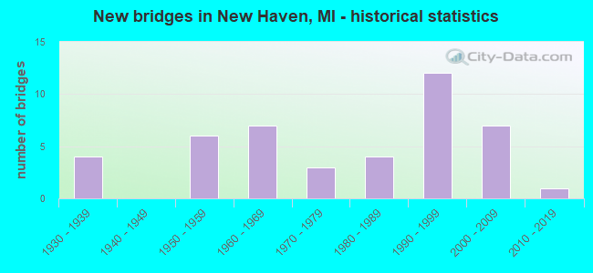
- New bridges - historical statistics
- 41930-1939
- 61950-1959
- 71960-1969
- 31970-1979
- 41980-1989
- 121990-1999
- 72000-2009
- 12010-2019
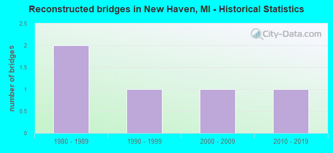
- Reconstructed bridges - Historical Statistics
- 21980-1989
- 11990-1999
- 12000-2009
- 12010-2019
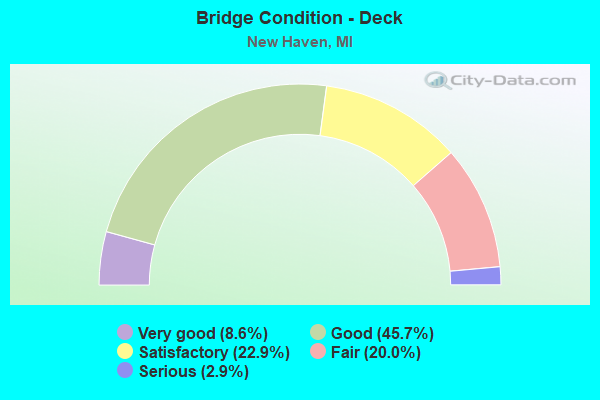
- Bridge Condition - Deck
- 8.6%Very good
- 45.7%Good
- 22.9%Satisfactory
- 20.0%Fair
- 2.9%Serious
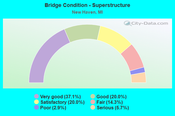
- Bridge Condition - Superstructure
- 37.1%Very good
- 20.0%Good
- 20.0%Satisfactory
- 14.3%Fair
- 2.9%Poor
- 5.7%Serious
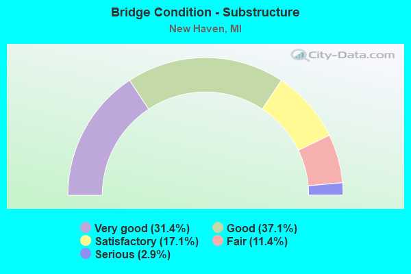
- Bridge Condition - Substructure
- 31.4%Very good
- 37.1%Good
- 17.1%Satisfactory
- 11.4%Fair
- 2.9%Serious
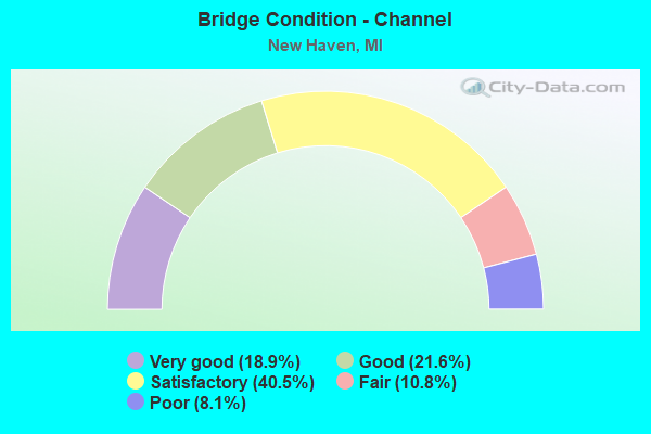
- Bridge Condition - Channel
- 18.9%Very good
- 21.6%Good
- 40.5%Satisfactory
- 10.8%Fair
- 8.1%Poor
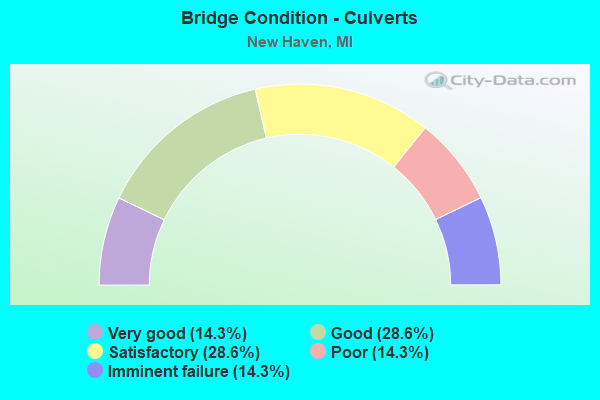
- Bridge Condition - Culverts
- 14.3%Very good
- 28.6%Good
- 28.6%Satisfactory
- 14.3%Poor
- 14.3%Imminent failure
Find on map >> Show street view
Structure Number: 10179, Location: SEC. 14-15 GREENWOOD TWP (Lat: 43.122414, Lng: -82.679756), Route carried "on" structure: County highway , Year Built: 1980, Status: Open, Structure Length: 0.85m (2.79ft), Average Daily Traffic: 66 (year 1994), Average Future Daily Traffic: 202 (year 2014), Design Load: HS 20+Mod, Features Intersected: EVES DRAIN, Facility Carried by Structure: DUCE ROAD
Minimum Vertical Clearance: 30.48m (100.00ft), Kilometerpoint: 8.155, Lanes on structure: 2, Owner: County Highway Agency, Approaching Roadway Width: 6.7m (22.0ft), Material/Design: Steel, Design/Construction: Culvert, Number Of Spans In Main Unit: 2, Length of Maximum Span: 3.9m (12.8ft)
Condition: Channel: Fair, Culverts: Satisfactory, Operating Rating: 31.8 metric tons, Method Used To Determine Operating Rating: Load and Resistance Factor Rating (LRFR) rating reported by rating factor(RF) method using HL-93 loadings, Inventory Rating: 24.3 metric tons, Method Used To Determine Inventory Rating: Load and Resistance Factor Rating (LRFR) rating reported by rating factor(RF) method using HL-93 loadings, Structural Evaluation: Equal to present minimum criteria, Waterway Adequacy: Equal to present minimum criteria, Approach Roadway Alignment: Better than present minimum criteria, Length Of Structure Improvement: 2.29m (7.51ft), Designated Inspection Frequency: Every 24 months, Inspection Date: Febuary 2021, Roadway Improvement Cost: $9,000, Total Project Cost: $10,000
Find on map >> Show street view
Structure Number: 12656, Location: 0.5 MI EAST OF GRATIOT (Lat: 42.704497, Lng: -82.797181), Route carried "on" structure: Alternate County highway , Year Built: 1995, Status: Posted for load, Structure Length: 0.79m (2.59ft), Average Daily Traffic: 480 (year 2008), Truck Traffic: 2%, Average Future Daily Traffic: 647 (year 2028), Design Load: HS 20, Features Intersected: FISH CREEK, Facility Carried by Structure: 25 MILE ROAD
Minimum Vertical Clearance: 30.48m (100.00ft), Kilometerpoint: 5.477, Lanes on structure: 2, Owner: County Highway Agency, Approaching Roadway Width: 6.0m (19.7ft), Material/Design: Wood or Timber, Design/Construction: Slab, Number Of Spans In Main Unit: 1, Length of Maximum Span: 7.6m (24.9ft), Curb or Sidewalk Widths: Left: 1.5m (4.9ft), Right: 1.5m (4.9ft), Curb-To-Curb Width: 12.0m (39.4ft), Out-to-Out Width: 19.8m (65.0ft)
Condition: Deck: Good, Superstructure: Very good, Substructure: Very good, Channel: Satisfactory, Operating Rating: 35.3 metric tons, Method Used To Determine Operating Rating: Allowable Stress (AS) rating reported by rating factor (RF) method using MS18 loading, Inventory Rating: 24.6 metric tons, Method Used To Determine Inventory Rating: Allowable Stress (AS) rating reported by rating factor (RF) method using MS18 loading, Structural Evaluation: Equal to present minimum criteria, Deck Geometry: Better than present minimum criteria, Waterway Adequacy: Better than present minimum criteria, Approach Roadway Alignment: Equal to present desirable criteria, Bridge Posting: Required (Relationship of Operating Rating to Maximum Legal Load: 20.0 - 29.9% below), Designated Inspection Frequency: Every 24 months, Inspection Date: September 2021, Deck Structure Type: Wood or Timber, Wearing Surface/Protective System: Wearing Surface: Bituminous
Find on map >> Show street view
Structure Number: 12865, Location: 0.1 MI SE OF DONNER RD (Lat: 42.658800, Lng: -82.818997), Route carried "on" structure: County highway , Year Built: 1999, Status: Open, Structure Length: 1.65m (5.41ft), Average Daily Traffic: 250 (year 1999), Average Future Daily Traffic: 340 (year 2019), Design Load: HS 20, Features Intersected: SUTHERLAND - OEMIG DRAIN, Facility Carried by Structure: IRIS DRIVE
Minimum Vertical Clearance: 30.48m (100.00ft), Kilometerpoint: 0.179, Lanes on structure: 2, Owner: County Highway Agency, Approaching Roadway Width: 8.0m (26.2ft), Material/Design: Wood or Timber, Design/Construction: Slab, Number Of Spans In Main Unit: 3, Length of Maximum Span: 5.5m (18.0ft), Curb or Sidewalk Widths: Left: 1.8m (5.9ft), Right: 1.8m (5.9ft), Curb-To-Curb Width: 9.0m (29.5ft), Out-to-Out Width: 13.6m (44.6ft)
Condition: Deck: Good, Superstructure: Very good, Substructure: Very good, Channel: Satisfactory, Operating Rating: 43.4 metric tons, Method Used To Determine Operating Rating: Allowable Stress (AS) rating reported by rating factor (RF) method using MS18 loading, Inventory Rating: 31.8 metric tons, Method Used To Determine Inventory Rating: Allowable Stress (AS) rating reported by rating factor (RF) method using MS18 loading, Structural Evaluation: Better than present minimum criteria, Deck Geometry: Equal to present minimum criteria, Waterway Adequacy: Superior to present desirable criteria, Approach Roadway Alignment: Equal to present desirable criteria, Designated Inspection Frequency: Every 24 months, Inspection Date: September 2021, Deck Structure Type: Wood or Timber, Wearing Surface/Protective System: Wearing Surface: Bituminous, Deck Protection: Other
Find on map >> Show street view
Structure Number: 14318, Location: 1000' E OF PLACE RD (Lat: 42.748500, Lng: -82.828700), Route carried "on" structure: County highway , Year Built: 1968, Status: Closed, Structure Length: 0.63m (2.07ft), Average Daily Traffic: 70 (year 2015), Truck Traffic: 2%, Average Future Daily Traffic: 100 (year 2035), Design Load: HS 20, Features Intersected: DEER CREEK, Facility Carried by Structure: 28 MILE RD
Minimum Vertical Clearance: 30.48m (100.00ft), Kilometerpoint: 0.982, Lanes on structure: 2, Owner: County Highway Agency, Approaching Roadway Width: 6.7m (22.0ft), Material/Design: Steel, Design/Construction: Culvert, Number Of Spans In Main Unit: 2, Length of Maximum Span: 3.0m (9.8ft), Curb-To-Curb Width: 6.7m (22.0ft), Out-to-Out Width: 8.5m (27.9ft)
Condition: Channel: Satisfactory, Culverts: Imminent failure, Deck Geometry: Somewhat better than minimum adequacy, Waterway Adequacy: Equal to present minimum criteria, Approach Roadway Alignment: Equal to present minimum criteria, Bridge Posting: Required (Relationship of Operating Rating to Maximum Legal Load: > 39.9% below), Designated Inspection Frequency: Every 24 months, Inspection Date: July 2021, Wearing Surface/Protective System: Wearing Surface: Gravel
Find on map >> Show street view
Structure Number: 6176, Location: 1.0 MI S OF M-29 (Lat: 42.663639, Lng: -82.829225), Route carried "under" structure: Interstate 94, Year Built: 1963, Structure Length: 0. m, Average Daily Traffic: 103,472 (year 2007), Truck Traffic: 7%, Features Intersected: I-94, Facility Carried by Structure: COTTON RD
Minimum Vertical Clearance: 5.08m (16.67ft), Kilometerpoint: 27.155, Lanes on structure: 2, Lanes under structure: 6, Material/Design: Steel, Design/Construction: Stringer/Multi-beam, Length of Maximum Span: 25.9m (85.0ft)
Find on map >> Show street view
Structure Number: 6182, Location: @ M-3 & M-29 (Lat: 42.674361, Lng: -82.820375), Route carried "under" structure: Interstate 94, Year Built: 1963, Structure Length: 0. m, Average Daily Traffic: 103,472 (year 2007), Truck Traffic: 9%, Features Intersected: I-94, Facility Carried by Structure: M-3 & M-29
Minimum Vertical Clearance: 4.90m (16.08ft), Kilometerpoint: 28.570, Lanes on structure: 4, Lanes under structure: 6, Material/Design: Steel, Design/Construction: Stringer/Multi-beam, Length of Maximum Span: 36.8m (120.7ft)