Bridge Statistics for North Little Rock, Arkansas (AR)
Condition, Traffic, Stress, Structural Evaluation, Project Costs
- National Bridge Inventory (NBI) Statistics
- 252Number of bridges
- 3,658ft / 1,115mTotal length
- $39,971,000Total costs
- 5,794,084Total average daily traffic
- 230,641Total average daily truck traffic
- National Bridge Inventory (NBI) Registered Bridges for North Little Rock
- No street view available for this location
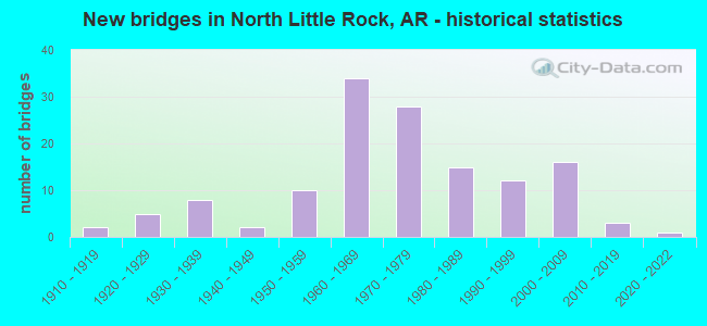
- New bridges - historical statistics
- 21910-1919
- 51920-1929
- 81930-1939
- 21940-1949
- 101950-1959
- 341960-1969
- 281970-1979
- 151980-1989
- 121990-1999
- 162000-2009
- 32010-2019
- 12020-2022
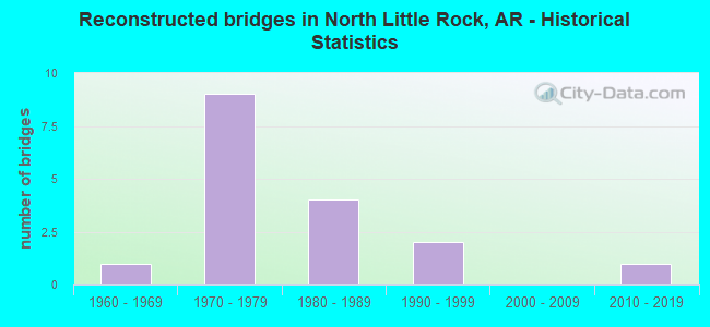
- Reconstructed bridges - Historical Statistics
- 11960-1969
- 91970-1979
- 41980-1989
- 21990-1999
- 02000-2009
- 12010-2019
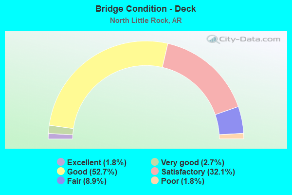
- Bridge Condition - Deck
- 1.8%Excellent
- 2.7%Very good
- 52.7%Good
- 32.1%Satisfactory
- 8.9%Fair
- 1.8%Poor
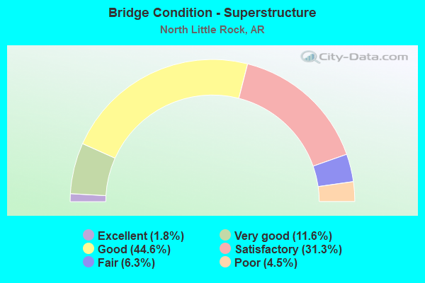
- Bridge Condition - Superstructure
- 1.8%Excellent
- 11.6%Very good
- 44.6%Good
- 31.3%Satisfactory
- 6.3%Fair
- 4.5%Poor
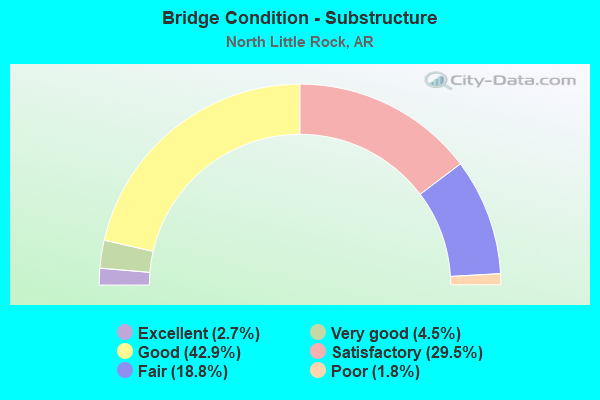
- Bridge Condition - Substructure
- 2.7%Excellent
- 4.5%Very good
- 42.9%Good
- 29.5%Satisfactory
- 18.8%Fair
- 1.8%Poor
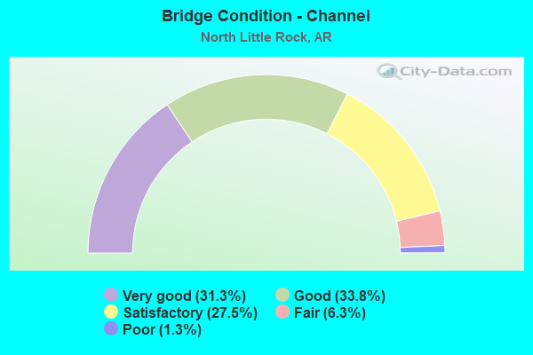
- Bridge Condition - Channel
- 31.3%Very good
- 33.8%Good
- 27.5%Satisfactory
- 6.3%Fair
- 1.3%Poor
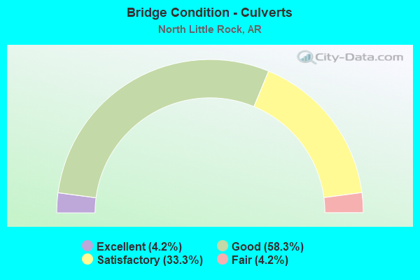
- Bridge Condition - Culverts
- 4.2%Excellent
- 58.3%Good
- 33.3%Satisfactory
- 4.2%Fair
Find on map >> Show street view
Structure Number: G2768, Location: 0.8 MI SO OF I- 40(I-5) (Lat: 34.768089, Lng: -92.261872), Route carried "on" structure: Interstate 30, Year Built: 1961, Year Reconstructed: 1983, Status: Open, Structure Length: 2.68m (8.79ft), Average Daily Traffic: 119,000 (year 2018), Truck Traffic: 1%, Average Future Daily Traffic: 150,355 (year 2028), Design Load: HS 20+Mod, Features Intersected: EAST 15TH ST Sykes
Minimum Vertical Clearance: 30+ m (98+ ft), Kilometerpoint: 228.527, Lanes on structure: 6, Lanes under structure: 2, Base Highway Network: Yes, Owner: State Highway Agency, Approaching Roadway Width: 17.7m (58.1ft), Skew: 30 degrees, Material/Design: Steel, Design/Construction: Stringer/Multi-beam, Number Of Spans In Main Unit: 1, Length of Maximum Span: 26.2m (86.0ft), Curb-To-Curb Width: 35.4m (116.1ft), Out-to-Out Width: 36.9m (121.1ft)
Condition: Deck: Good, Superstructure: Good, Substructure: Satisfactory, Operating Rating: 54.4 metric tons, Method Used To Determine Operating Rating: Load Factor (LF), Inventory Rating: 32.7 metric tons, Method Used To Determine Inventory Rating: Load Factor (LF), Structural Evaluation: Equal to present minimum criteria, Deck Geometry: Superior to present desirable criteria, Underclear: Meets minimum limits, Approach Roadway Alignment: Equal to present desirable criteria, Designated Inspection Frequency: Every 24 months, Critical Feature Inspection Frequency: Every 24 months, Inspection Date: July 2021, Deck Structure Type: Concrete Cast-file-Place, Wearing Surface/Protective System: Wearing Surface: Monolithic Concrete
Find on map >> Show street view
Structure Number: H2768, Location: 0.62 MI SO OF I- 40(I-5) (Lat: 34.771881, Lng: -92.261719), Route carried "on" structure: Interstate 30, Year Built: 1961, Year Reconstructed: 1983, Status: Open, Structure Length: 2.23m (7.32ft), Average Daily Traffic: 121,088 (year 2016), Truck Traffic: 1%, Average Future Daily Traffic: 149,059 (year 2028), Design Load: HS 20+Mod, Features Intersected: EAST 19TH STREET
Minimum Vertical Clearance: 30+ m (98+ ft), Kilometerpoint: 228.978, Lanes on structure: 7, Lanes under structure: 2, Base Highway Network: Yes, Owner: State Highway Agency, Approaching Roadway Width: 17.7m (58.1ft), Skew: 32 degrees, Material/Design: Steel, Design/Construction: Stringer/Multi-beam, Number Of Spans In Main Unit: 1, Length of Maximum Span: 21.6m (70.9ft), Curb-To-Curb Width: 36.5m (119.8ft), Out-to-Out Width: 38.2m (125.3ft)
Condition: Deck: Good, Superstructure: Good, Substructure: Satisfactory, Operating Rating: 54.4 metric tons, Method Used To Determine Operating Rating: Load Factor (LF), Inventory Rating: 32.7 metric tons, Method Used To Determine Inventory Rating: Load Factor (LF), Structural Evaluation: Equal to present minimum criteria, Deck Geometry: Superior to present desirable criteria, Underclear: Equal to present minimum criteria, Approach Roadway Alignment: Equal to present desirable criteria, Designated Inspection Frequency: Every 24 months, Critical Feature Inspection Frequency: Every 24 months, Inspection Date: July 2021, Deck Structure Type: Concrete Cast-file-Place, Wearing Surface/Protective System: Wearing Surface: Monolithic Concrete
Find on map >> Show street view
Structure Number: K2768, Location: 1.8 MI SO OF I- 40(I-8) (Lat: 34.753869, Lng: -92.262450), Route carried "on" structure: Interstate 30, Year Built: 1961, Status: Open, Structure Length: 2.68m (8.79ft), Average Daily Traffic: 125,000 (year 2018), Truck Traffic: 1%, Average Future Daily Traffic: 158,132 (year 2028), Design Load: HS 20+Mod, Features Intersected: WASHINGTON AVE NLR
Minimum Vertical Clearance: 30+ m (98+ ft), Kilometerpoint: 226.966, Lanes on structure: 7, Lanes under structure: 3, Base Highway Network: Yes, Owner: State Highway Agency, Approaching Roadway Width: 40.8m (133.9ft), Skew: 30 degrees, Material/Design: Steel, Design/Construction: Stringer/Multi-beam, Number Of Spans In Main Unit: 1, Length of Maximum Span: 25.6m (84.0ft), Curb-To-Curb Width: 37.1m (121.7ft), Out-to-Out Width: 38.6m (126.6ft)
Condition: Deck: Satisfactory, Superstructure: Good, Substructure: Fair, Operating Rating: 54.4 metric tons, Method Used To Determine Operating Rating: Load Factor (LF), Inventory Rating: 32.7 metric tons, Method Used To Determine Inventory Rating: Load Factor (LF), Structural Evaluation: Somewhat better than minimum adequacy, Deck Geometry: Superior to present desirable criteria, Underclear: Somewhat better than minimum adequacy, Approach Roadway Alignment: Equal to present desirable criteria, Length Of Structure Improvement: 3.47m (11.38ft), Designated Inspection Frequency: Every 24 months, Critical Feature Inspection Frequency: Every 24 months, Inspection Date: Febuary 2022, Roadway Improvement Cost: $603,000, Total Project Cost: $1,511,000, Deck Structure Type: Concrete Cast-file-Place, Wearing Surface/Protective System: Wearing Surface: Monolithic Concrete
Find on map >> Show street view
Structure Number: M2967, Location: 6.3MI SO FAULKNER CO/I-2 (Lat: 34.884339, Lng: -92.352578), Route carried "on" structure: State highway 365, Year Built: 1919, Status: Posted for load, Structure Length: 1.28m (4.20ft), Average Daily Traffic: 5,085 (year 2018), Truck Traffic: 4%, Average Future Daily Traffic: 7,907 (year 2028), Features Intersected: BR WHITE OAK BAYOU
Minimum Vertical Clearance: 30+ m (98+ ft), Kilometerpoint: 10.137, Lanes on structure: 2, Base Highway Network: Yes, Owner: State Highway Agency, Approaching Roadway Width: 7.9m (25.9ft), Material/Design: Steel, Design/Construction: Stringer/Multi-beam, Number Of Spans In Main Unit: 1, Length of Maximum Span: 12.1m (39.7ft), Curb or Sidewalk Widths: Left: 0.4m (1.3ft), Right: 0.4m (1.3ft), Curb-To-Curb Width: 7.9m (25.9ft), Out-to-Out Width: 8.7m (28.5ft)
Condition: Deck: Good, Superstructure: Satisfactory, Substructure: Good, Channel: Satisfactory, Operating Rating: 34.5 metric tons, Method Used To Determine Operating Rating: Load Factor (LF), Inventory Rating: 20.9 metric tons, Method Used To Determine Inventory Rating: Load Factor (LF), Structural Evaluation: Somewhat better than minimum adequacy, Deck Geometry: High priority of replacement, Waterway Adequacy: Equal to present desirable criteria, Approach Roadway Alignment: Equal to present desirable criteria, Bridge Posting: Required (Relationship of Operating Rating to Maximum Legal Load: 10.0 - 19.9% below), Length Of Structure Improvement: 2.04m (6.69ft), Designated Inspection Frequency: Every 24 months, Critical Feature Inspection Frequency: Every 24 months, Inspection Date: Febuary 2022, Roadway Improvement Cost: $265,000, Total Project Cost: $565,000, Deck Structure Type: Concrete Cast-file-Place, Wearing Surface/Protective System: Wearing Surface: Bituminous
Find on map >> Show street view
Structure Number: M2968, Location: 8.5 MI N OF I-40 (Lat: 34.883050, Lng: -92.351850), Route carried "on" structure: State highway 365, Year Built: 1919, Status: Open, Structure Length: 1.31m (4.30ft), Average Daily Traffic: 5,085 (year 2018), Truck Traffic: 4%, Average Future Daily Traffic: 7,907 (year 2028), Design Load: H 15, Features Intersected: WHITE OAK BAYOU
Minimum Vertical Clearance: 30+ m (98+ ft), Kilometerpoint: 10.284, Lanes on structure: 2, Base Highway Network: Yes, Owner: State Highway Agency, Approaching Roadway Width: 8.5m (27.9ft), Material/Design: Steel, Design/Construction: Stringer/Multi-beam, Number Of Spans In Main Unit: 1, Length of Maximum Span: 12.1m (39.7ft), Curb or Sidewalk Widths: Left: 0.4m (1.3ft), Right: 0.4m (1.3ft), Curb-To-Curb Width: 7.9m (25.9ft), Out-to-Out Width: 8.7m (28.5ft)
Condition: Deck: Good, Superstructure: Satisfactory, Substructure: Satisfactory, Channel: Satisfactory, Operating Rating: 39.0 metric tons, Method Used To Determine Operating Rating: Load Factor (LF), Inventory Rating: 23.6 metric tons, Method Used To Determine Inventory Rating: Load Factor (LF), Structural Evaluation: Somewhat better than minimum adequacy, Deck Geometry: High priority of replacement, Waterway Adequacy: Equal to present desirable criteria, Approach Roadway Alignment: Equal to present desirable criteria, Length Of Structure Improvement: 2.04m (6.69ft), Designated Inspection Frequency: Every 24 months, Critical Feature Inspection Frequency: Every 24 months, Inspection Date: Febuary 2022, Roadway Improvement Cost: $265,000, Total Project Cost: $565,000, Deck Structure Type: Concrete Cast-file-Place, Wearing Surface/Protective System: Wearing Surface: Bituminous
Find on map >> Show street view
Structure Number: M2971, Location: 4.78 MI N OF I40/I-2 (Lat: 34.833219, Lng: -92.332011), Route carried "on" structure: State highway 365, Year Built: 1930, Status: Open, Structure Length: 0.66m (2.17ft), Average Daily Traffic: 7,181 (year 2018), Truck Traffic: 1%, Average Future Daily Traffic: 10,499 (year 2028), Design Load: H 15, Features Intersected: BRANCH
Minimum Vertical Clearance: 30+ m (98+ ft), Kilometerpoint: 16.332, Lanes on structure: 2, Base Highway Network: Yes, Owner: State Highway Agency, Approaching Roadway Width: 12.2m (40.0ft), Material/Design: Concrete, Design/Construction: Slab, Number Of Spans In Main Unit: 1, Length of Maximum Span: 6.2m (20.3ft), Curb-To-Curb Width: 11.7m (38.4ft), Out-to-Out Width: 12.2m (40.0ft)
Condition: Deck: Good, Superstructure: Good, Substructure: Good, Channel: Fair, Operating Rating: 33.6 metric tons, Method Used To Determine Operating Rating: Load Factor (LF), Inventory Rating: 20.0 metric tons, Method Used To Determine Inventory Rating: Load Factor (LF), Structural Evaluation: Somewhat better than minimum adequacy, Deck Geometry: Somewhat better than minimum adequacy, Waterway Adequacy: Equal to present desirable criteria, Approach Roadway Alignment: Equal to present desirable criteria, Designated Inspection Frequency: Every 24 months, Critical Feature Inspection Frequency: Every 24 months, Inspection Date: January 2022, Deck Structure Type: Concrete Cast-file-Place, Wearing Surface/Protective System: Wearing Surface: Bituminous
Find on map >> Show street view
Structure Number: M2972, Location: 3.29 MI N OF I - 40 (Lat: 34.817261, Lng: -92.315039), Route carried "on" structure: State highway 365, Year Built: 1930, Status: Open, Structure Length: 0.70m (2.30ft), Average Daily Traffic: 7,181 (year 2018), Truck Traffic: 1%, Average Future Daily Traffic: 12,962 (year 2028), Design Load: H 15, Features Intersected: CREEK
Minimum Vertical Clearance: 30+ m (98+ ft), Kilometerpoint: 18.730, Lanes on structure: 2, Base Highway Network: Yes, Owner: State Highway Agency, Approaching Roadway Width: 12.2m (40.0ft), Material/Design: Concrete, Design/Construction: Slab, Number Of Spans In Main Unit: 1, Length of Maximum Span: 6.1m (20.0ft), Curb-To-Curb Width: 11.7m (38.4ft), Out-to-Out Width: 12.2m (40.0ft)
Condition: Deck: Good, Superstructure: Good, Substructure: Good, Channel: Satisfactory, Operating Rating: 33.6 metric tons, Method Used To Determine Operating Rating: Load Factor (LF), Inventory Rating: 20.0 metric tons, Method Used To Determine Inventory Rating: Load Factor (LF), Structural Evaluation: Somewhat better than minimum adequacy, Deck Geometry: Somewhat better than minimum adequacy, Waterway Adequacy: Equal to present desirable criteria, Approach Roadway Alignment: Equal to present desirable criteria, Designated Inspection Frequency: Every 24 months, Critical Feature Inspection Frequency: Every 24 months, Inspection Date: January 2022, Deck Structure Type: Concrete Cast-file-Place, Wearing Surface/Protective System: Wearing Surface: Bituminous
Find on map >> Show street view
Structure Number: M2973, Location: 3.02 MI N OF I 40 (Lat: 34.814169, Lng: -92.312111), Route carried "on" structure: State highway 365, Year Built: 1930, Status: Open, Structure Length: 0.78m (2.56ft), Average Daily Traffic: 7,181 (year 2018), Truck Traffic: 1%, Average Future Daily Traffic: 12,962 (year 2028), Design Load: H 15, Features Intersected: CREEK
Minimum Vertical Clearance: 30+ m (98+ ft), Kilometerpoint: 19.119, Lanes on structure: 2, Base Highway Network: Yes, Owner: State Highway Agency, Approaching Roadway Width: 12.2m (40.0ft), Material/Design: Concrete, Design/Construction: Slab, Number Of Spans In Main Unit: 1, Length of Maximum Span: 6.1m (20.0ft), Curb-To-Curb Width: 11.8m (38.7ft), Out-to-Out Width: 12.3m (40.4ft)
Condition: Deck: Good, Superstructure: Good, Substructure: Good, Channel: Satisfactory, Operating Rating: 37.2 metric tons, Method Used To Determine Operating Rating: Load Factor (LF), Inventory Rating: 22.7 metric tons, Method Used To Determine Inventory Rating: Load Factor (LF), Structural Evaluation: Somewhat better than minimum adequacy, Deck Geometry: Somewhat better than minimum adequacy, Waterway Adequacy: Better than present minimum criteria, Approach Roadway Alignment: Better than present minimum criteria, Designated Inspection Frequency: Every 24 months, Critical Feature Inspection Frequency: Every 24 months, Inspection Date: January 2022, Deck Structure Type: Concrete Cast-file-Place, Wearing Surface/Protective System: Wearing Surface: Bituminous
Find on map >> Show street view
Structure Number: M2974, Location: 0.79 MI N I-40 (I-5) (Lat: 34.794581, Lng: -92.288731), Route carried "on" structure: State highway 365, Year Built: 1941, Status: Open, Structure Length: 1.01m (3.31ft), Average Daily Traffic: 9,367 (year 2018), Truck Traffic: 1%, Average Future Daily Traffic: 14,258 (year 2028), Features Intersected: DITCH
Minimum Vertical Clearance: 30+ m (98+ ft), Kilometerpoint: 22.751, Lanes on structure: 3, Base Highway Network: Yes, Owner: State Highway Agency, Approaching Roadway Width: 13.4m (44.0ft), Material/Design: Concrete, Design/Construction: Culvert, Number Of Spans In Main Unit: 3, Length of Maximum Span: 3.0m (9.8ft), Curb or Sidewalk Widths: Left: 1.1m (3.6ft), Right: 0.0m, Curb-To-Curb Width: 13.5m (44.3ft), Out-to-Out Width: 14.9m (48.9ft)
Condition: Channel: Satisfactory, Culverts: Satisfactory, Operating Rating: 29.9 metric tons, Method Used To Determine Operating Rating: Load Factor (LF), Inventory Rating: 18.1 metric tons, Method Used To Determine Inventory Rating: Load Factor (LF), Structural Evaluation: Meets minimum limits, Deck Geometry: Somewhat better than minimum adequacy, Waterway Adequacy: Equal to present desirable criteria, Approach Roadway Alignment: Equal to present desirable criteria, Length Of Structure Improvement: 1.71m (5.61ft), Designated Inspection Frequency: Every 24 months, Critical Feature Inspection Frequency: Every 24 months, Inspection Date: January 2022, Roadway Improvement Cost: $305,000, Total Project Cost: $595,000
Find on map >> Show street view
Structure Number: M2975, Location: 0.28 MI N OF I-40 (Lat: 34.789319, Lng: -92.282889), Route carried "on" structure: State highway 365, Year Built: 1941, Status: Open, Structure Length: 0.70m (2.30ft), Average Daily Traffic: 9,367 (year 2018), Truck Traffic: 1%, Average Future Daily Traffic: 14,258 (year 2028), Features Intersected: Shilcotts Bayou
Minimum Vertical Clearance: 30+ m (98+ ft), Kilometerpoint: 23.556, Lanes on structure: 3, Base Highway Network: Yes, Owner: State Highway Agency, Approaching Roadway Width: 13.7m (44.9ft), Material/Design: Concrete, Design/Construction: Culvert, Number Of Spans In Main Unit: 2, Length of Maximum Span: 3.0m (9.8ft), Curb-To-Curb Width: 19.2m (63.0ft), Out-to-Out Width: 19.8m (65.0ft)
Condition: Channel: Good, Culverts: Satisfactory, Operating Rating: 30.8 metric tons, Method Used To Determine Operating Rating: Load Factor (LF), Inventory Rating: 18.1 metric tons, Method Used To Determine Inventory Rating: Load Factor (LF), Structural Evaluation: Meets minimum limits, Deck Geometry: Superior to present desirable criteria, Waterway Adequacy: Equal to present desirable criteria, Approach Roadway Alignment: Equal to present desirable criteria, Designated Inspection Frequency: Every 24 months, Critical Feature Inspection Frequency: Every 24 months, Inspection Date: January 2022
Find on map >> Show street view
Structure Number: M3034, Location: 1.4 MI N SH 70 (I-5) (Lat: 34.775678, Lng: -92.259339), Route carried "on" structure: Interstate 30, Year Built: 1961, Status: Open, Structure Length: 0.94m (3.08ft), Average Daily Traffic: 60,544 (year 2016), Truck Traffic: 1%, Average Future Daily Traffic: 149,059 (year 2028), Design Load: HS 20+Mod, Features Intersected: CREEK
Minimum Vertical Clearance: 30+ m (98+ ft), Kilometerpoint: 229.460, Lanes on structure: 2, Base Highway Network: Yes, Owner: State Highway Agency, Approaching Roadway Width: 11.0m (36.1ft), Material/Design: Concrete, Design/Construction: Culvert, Number Of Spans In Main Unit: 2, Length of Maximum Span: 4.9m (16.1ft), Curb-To-Curb Width: 11.7m (38.4ft), Out-to-Out Width: 12.3m (40.4ft)
Condition: Channel: Very good, Culverts: Good, Operating Rating: 54.4 metric tons, Method Used To Determine Operating Rating: Load Factor (LF), Inventory Rating: 34.5 metric tons, Method Used To Determine Inventory Rating: Load Factor (LF), Structural Evaluation: Better than present minimum criteria, Deck Geometry: Equal to present minimum criteria, Waterway Adequacy: Equal to present desirable criteria, Approach Roadway Alignment: Equal to present desirable criteria, Designated Inspection Frequency: Every 24 months, Critical Feature Inspection Frequency: Every 24 months, Inspection Date: December 2020
Find on map >> Show street view
Structure Number: M3035, Location: 1.4MI NO OF US 70 (Lat: 34.776239, Lng: -92.260197), Route carried "on" structure: Ramp Interstate 30, Year Built: 1960, Status: Open, Structure Length: 1.04m (3.41ft), Average Daily Traffic: 38,000 (year 2018), Truck Traffic: 1%, Average Future Daily Traffic: 38,885 (year 2024), Design Load: HS 20+Mod, Features Intersected: CREEK
Minimum Vertical Clearance: 30+ m (98+ ft), Kilometerpoint: 229.637, Lanes on structure: 4, Base Highway Network: Yes, Owner: State Highway Agency, Approaching Roadway Width: 11.6m (38.1ft), Skew: 11 degrees, Material/Design: Concrete, Design/Construction: Culvert, Number Of Spans In Main Unit: 2, Length of Maximum Span: 4.7m (15.4ft)
Condition: Channel: Very good, Culverts: Satisfactory, Operating Rating: 54.4 metric tons, Method Used To Determine Operating Rating: Load Factor (LF), Inventory Rating: 32.7 metric tons, Method Used To Determine Inventory Rating: Load Factor (LF), Structural Evaluation: Equal to present minimum criteria, Waterway Adequacy: Equal to present desirable criteria, Approach Roadway Alignment: Equal to present desirable criteria, Designated Inspection Frequency: Every 24 months, Critical Feature Inspection Frequency: Every 24 months, Inspection Date: December 2020
Find on map >> Show street view
Structure Number: M3038, Location: 1.3 MI SE OF I-430 (I-5) (Lat: 34.809831, Lng: -92.318650), Route carried "on" structure: Interstate 40, Year Built: 1963, Status: Open, Structure Length: 0.70m (2.30ft), Average Daily Traffic: 84,000 (year 2018), Truck Traffic: 1%, Average Future Daily Traffic: 95,916 (year 2028), Design Load: H 20, Features Intersected: CREEK
Minimum Vertical Clearance: 30+ m (98+ ft), Kilometerpoint: 239.821, Lanes on structure: 6, Base Highway Network: Yes, Owner: State Highway Agency, Approaching Roadway Width: 23.2m (76.1ft), Material/Design: Concrete, Design/Construction: Culvert, Number Of Spans In Main Unit: 2, Length of Maximum Span: 3.0m (9.8ft)
Condition: Channel: Satisfactory, Culverts: Fair, Operating Rating: 39.9 metric tons, Method Used To Determine Operating Rating: Load Factor (LF), Inventory Rating: 23.6 metric tons, Method Used To Determine Inventory Rating: Load Factor (LF), Structural Evaluation: Somewhat better than minimum adequacy, Waterway Adequacy: Equal to present desirable criteria, Approach Roadway Alignment: Equal to present desirable criteria, Designated Inspection Frequency: Every 24 months, Critical Feature Inspection Frequency: Every 24 months, Inspection Date: March 2021
Find on map >> Show street view
Structure Number: M3039, Location: 0.1 MI W JCT US67 & I40 (Lat: 34.777219, Lng: -92.239050), Route carried "on" structure: Interstate 40, Year Built: 1963, Status: Open, Structure Length: 1.19m (3.90ft), Average Daily Traffic: 115,477 (year 2018), Truck Traffic: 1%, Average Future Daily Traffic: 138,690 (year 2028), Design Load: H 20, Features Intersected: Dark Hollow Drain
Minimum Vertical Clearance: 30+ m (98+ ft), Kilometerpoint: 248.574, Lanes on structure: 8, Base Highway Network: Yes, Owner: State Highway Agency, Approaching Roadway Width: 29.3m (96.1ft), Skew: 30 degrees, Material/Design: Concrete, Design/Construction: Culvert, Number Of Spans In Main Unit: 3, Length of Maximum Span: 3.7m (12.1ft)
Condition: Channel: Satisfactory, Culverts: Satisfactory, Operating Rating: 31.8 metric tons, Method Used To Determine Operating Rating: Load Factor (LF), Inventory Rating: 19.1 metric tons, Method Used To Determine Inventory Rating: Load Factor (LF), Structural Evaluation: Meets minimum limits, Waterway Adequacy: Better than present minimum criteria, Approach Roadway Alignment: Equal to present desirable criteria, Designated Inspection Frequency: Every 24 months, Critical Feature Inspection Frequency: Every 24 months, Inspection Date: December 2020
Find on map >> Show street view
Structure Number: X0202, Location: 1.4 MI N SH 70 (Lat: 34.775489, Lng: -92.259128), Route carried "on" structure: ServiceInterstate 30, Year Built: 1961, Status: Open, Structure Length: 1.01m (3.31ft), Average Daily Traffic: 1,464 (year 2014), Truck Traffic: 1%, Average Future Daily Traffic: 170 (year 2028), Design Load: H 20, Features Intersected: DITCH
Minimum Vertical Clearance: 30+ m (98+ ft), Kilometerpoint: 229.460, Lanes on structure: 2, Owner: State Highway Agency, Approaching Roadway Width: 7.0m (23.0ft), Material/Design: Concrete, Design/Construction: Culvert, Number Of Spans In Main Unit: 2, Length of Maximum Span: 4.9m (16.1ft), Curb-To-Curb Width: 10.1m (33.1ft), Out-to-Out Width: 12.2m (40.0ft)
Condition: Channel: Very good, Culverts: Good, Operating Rating: 54.4 metric tons, Method Used To Determine Operating Rating: Load Factor (LF), Inventory Rating: 32.7 metric tons, Method Used To Determine Inventory Rating: Load Factor (LF), Structural Evaluation: Better than present minimum criteria, Deck Geometry: Somewhat better than minimum adequacy, Waterway Adequacy: Better than present minimum criteria, Approach Roadway Alignment: Equal to present desirable criteria, Designated Inspection Frequency: Every 24 months, Critical Feature Inspection Frequency: Every 24 months, Inspection Date: December 2020
Find on map >> Show street view
Structure Number: X0203, Location: RAMP I40 E TO I30 W/I-5 (Lat: 34.776678, Lng: -92.261819), Route carried "on" structure: Ramp Interstate 40, Year Built: 1961, Status: Open, Structure Length: 0.76m (2.49ft), Average Daily Traffic: 81,000 (year 2018), Truck Traffic: 1%, Average Future Daily Traffic: 38,885 (year 2024), Design Load: H 20, Features Intersected: DITCH
Minimum Vertical Clearance: 30+ m (98+ ft), Kilometerpoint: 246.579, Lanes on structure: 2, Base Highway Network: Yes, Owner: State Highway Agency, Approaching Roadway Width: 11.0m (36.1ft), Material/Design: Concrete, Design/Construction: Culvert, Number Of Spans In Main Unit: 2, Length of Maximum Span: 3.7m (12.1ft), Curb-To-Curb Width: 11.4m (37.4ft), Out-to-Out Width: 12.2m (40.0ft)
Condition: Channel: Good, Culverts: Good, Operating Rating: 54.4 metric tons, Method Used To Determine Operating Rating: Load Factor (LF), Inventory Rating: 32.7 metric tons, Method Used To Determine Inventory Rating: Load Factor (LF), Structural Evaluation: Better than present minimum criteria, Deck Geometry: Superior to present desirable criteria, Waterway Adequacy: Equal to present desirable criteria, Approach Roadway Alignment: Equal to present desirable criteria, Designated Inspection Frequency: Every 24 months, Critical Feature Inspection Frequency: Every 24 months, Inspection Date: December 2020, Deck Structure Type: Concrete Cast-file-Place, Wearing Surface/Protective System: Wearing Surface: Monolithic Concrete
Find on map >> Show street view
Structure Number: X0407, Location: 2 MI N OF I-40 (I-6) (Lat: 34.798939, Lng: -92.216269), Route carried "on" structure: ServiceUS 67, Year Built: 1957, Status: Open, Structure Length: 0.77m (2.53ft), Average Daily Traffic: 5,490 (year 2018), Truck Traffic: 1%, Average Future Daily Traffic: 8,425 (year 2026), Design Load: H 20, Features Intersected: CREEK
Minimum Vertical Clearance: 30+ m (98+ ft), Kilometerpoint: 3.058, Lanes on structure: 2, Base Highway Network: Yes, Owner: State Highway Agency, Approaching Roadway Width: 7.9m (25.9ft), Skew: 4 degrees, Material/Design: Concrete, Design/Construction: Culvert, Number Of Spans In Main Unit: 3, Length of Maximum Span: 2.7m (8.9ft)
Condition: Channel: Good, Culverts: Good, Operating Rating: 49.9 metric tons, Method Used To Determine Operating Rating: Load Factor (LF), Inventory Rating: 29.9 metric tons, Method Used To Determine Inventory Rating: Load Factor (LF), Structural Evaluation: Better than present minimum criteria, Waterway Adequacy: Equal to present desirable criteria, Approach Roadway Alignment: Equal to present desirable criteria, Designated Inspection Frequency: Every 24 months, Critical Feature Inspection Frequency: Every 24 months, Inspection Date: July 2021
Find on map >> Show street view
Structure Number: X0418, Location: .2 E OF SH 107 (Lat: 34.832989, Lng: -92.227369), Route carried "on" structure: State highway 176, Year Built: 1981, Status: Open, Structure Length: 1.61m (5.28ft), Average Daily Traffic: 15,000 (year 2018), Truck Traffic: 1%, Average Future Daily Traffic: 19,443 (year 2028), Design Load: H 20, Features Intersected: WOODRUFF CREEK
Minimum Vertical Clearance: 30+ m (98+ ft), Kilometerpoint: 0.402, Lanes on structure: 5, Owner: State Highway Agency, Approaching Roadway Width: 18.3m (60.0ft), Skew: 3 degrees, Material/Design: Concrete, Design/Construction: Culvert, Number Of Spans In Main Unit: 5, Length of Maximum Span: 2.7m (8.9ft), Curb or Sidewalk Widths: Left: 1.5m (4.9ft), Right: 0.2m (0.7ft)
Condition: Channel: Satisfactory, Culverts: Satisfactory, Operating Rating: 54.4 metric tons, Method Used To Determine Operating Rating: Load Factor (LF), Inventory Rating: 32.7 metric tons, Method Used To Determine Inventory Rating: Load Factor (LF), Structural Evaluation: Equal to present minimum criteria, Waterway Adequacy: Equal to present desirable criteria, Approach Roadway Alignment: Equal to present desirable criteria, Length Of Structure Improvement: 2.29m (7.51ft), Designated Inspection Frequency: Every 24 months, Critical Feature Inspection Frequency: Every 24 months, Inspection Date: March 2022, Roadway Improvement Cost: $374,000, Total Project Cost: $868,000
Find on map >> Show street view
Structure Number: X0747, Location: 3.96 MI N JCT I-40 (Lat: 34.823981, Lng: -92.231339), Route carried "on" structure: State highway 107, Year Built: 1988, Status: Open, Structure Length: 0.91m (2.99ft), Average Daily Traffic: 28,751 (year 2018), Truck Traffic: 1%, Average Future Daily Traffic: 32,404 (year 2028), Design Load: H 20, Features Intersected: CREEK
Minimum Vertical Clearance: 30+ m (98+ ft), Kilometerpoint: 6.371, Lanes on structure: 5, Base Highway Network: Yes, Owner: State Highway Agency, Approaching Roadway Width: 15.8m (51.8ft), Skew: 5 degrees, Material/Design: Concrete, Design/Construction: Culvert, Number Of Spans In Main Unit: 3, Length of Maximum Span: 2.7m (8.9ft), Curb-To-Curb Width: 15.8m (51.8ft), Out-to-Out Width: 21.6m (70.9ft)
Condition: Channel: Very good, Culverts: Good, Operating Rating: 33.6 metric tons, Method Used To Determine Operating Rating: Load Factor (LF), Inventory Rating: 20.0 metric tons, Method Used To Determine Inventory Rating: Load Factor (LF), Structural Evaluation: Somewhat better than minimum adequacy, Deck Geometry: High priority of replacement, Waterway Adequacy: Equal to present desirable criteria, Approach Roadway Alignment: Equal to present desirable criteria, Length Of Structure Improvement: 0.91m (2.99ft), Designated Inspection Frequency: Every 24 months, Critical Feature Inspection Frequency: Every 24 months, Inspection Date: October 2021, Roadway Improvement Cost: $339,000, Total Project Cost: $519,000
Find on map >> Show street view
Structure Number: X1587, Location: 1.7M N of I40 (Lat: 34.804769, Lng: -92.265919), Route carried "on" structure: State highway 176, Year Built: 2020, Status: Open, Structure Length: 1.18m (3.87ft), Average Daily Traffic: 11,000 (year 2018), Truck Traffic: 2%, Average Future Daily Traffic: 15,000 (year 2040), Design Load: HL 93, Features Intersected: Shilcotts Bayou
Minimum Vertical Clearance: 30+ m (98+ ft), Kilometerpoint: 2.494, Lanes on structure: 3, Owner: State Highway Agency, Approaching Roadway Width: 11.6m (38.1ft), Skew: 3 degrees, Material/Design: Concrete, Design/Construction: Culvert, Number Of Spans In Main Unit: 5, Length of Maximum Span: 1.8m (5.9ft), Curb or Sidewalk Widths: Left: 2.6m (8.5ft), Right: 2.6m (8.5ft), Curb-To-Curb Width: 13.3m (43.6ft), Out-to-Out Width: 30.2m (99.1ft)
Condition: Channel: Very good, Culverts: Excellent, Operating Rating: 39.9 metric tons, Method Used To Determine Operating Rating: Load and Resistance Factor (LRFR), Inventory Rating: 30.8 metric tons, Method Used To Determine Inventory Rating: Load and Resistance Factor (LRFR), Structural Evaluation: Better than present minimum criteria, Deck Geometry: Somewhat better than minimum adequacy, Waterway Adequacy: Equal to present desirable criteria, Approach Roadway Alignment: Equal to present desirable criteria, Designated Inspection Frequency: Every 24 months, Critical Feature Inspection Frequency: Every 24 months, Inspection Date: November 2020
Find on map >> Show street view
Structure Number: 1981, Location: .10 MI N JCT US 70 (I-6) (Lat: 34.768514, Lng: -92.199433), Route carried "under" structure: State highway 161, Structure Length: 0. m, Average Daily Traffic: 12,000 (year 2014), Truck Traffic: 1%, Features Intersected: SH 161-SEC 3, Facility Carried by Structure: Ark. Midland R/R
Minimum Vertical Clearance: 4.20m (13.78ft), Kilometerpoint: 17.880, Length of Maximum Span: 0.0m
Find on map >> Show street view
Structure Number: 2132, Location: Main and 9th Street (Lat: 34.764806, Lng: -92.267472), Route carried "under" structure: City street 64590, Structure Length: 0. m, Average Daily Traffic: 325 (year 1983), Truck Traffic: 1%, Features Intersected: W 9TH ST & UPRR, Facility Carried by Structure: N MAIN STREET
Minimum Vertical Clearance: 4.81m (15.78ft), Kilometerpoint: 0.002, Length of Maximum Span: 0.0m
Find on map >> Show street view
Structure Number: 2572, Location: 0.4 MI W US 70 (I-8) (Lat: 34.758172, Lng: -92.279214), Route carried "under" structure: State highway 365, Structure Length: 0. m, Average Daily Traffic: 14,000 (year 2014), Truck Traffic: 1%, Features Intersected: SH 365-SEC 11, Facility Carried by Structure: UPRR
Minimum Vertical Clearance: 3.87m (12.70ft), Kilometerpoint: 27.320, Length of Maximum Span: 0.0m
Find on map >> Show street view
Structure Number: 3054, Location: 1.16 MI N I-40 (Lat: 34.789931, Lng: -92.225550), Route carried "under" structure: US 67, Structure Length: 0. m, Average Daily Traffic: 41,500 (year 2014), Truck Traffic: 1%, Features Intersected: US 67 NB Lns, Facility Carried by Structure: McCain Blvd Ovrp
Minimum Vertical Clearance: 5.45m (17.88ft), Kilometerpoint: 1.851, Length of Maximum Span: 0.0m
Find on map >> Show street view
Structure Number: 3054, Location: 1.16 MI N I-40 (Lat: 34.789931, Lng: -92.225550), Route carried "under" structure: US 67, Structure Length: 0. m, Average Daily Traffic: 41,500 (year 2014), Truck Traffic: 1%, Features Intersected: US 67 SB Lns, Facility Carried by Structure: McCain Blvd Ovrp
Minimum Vertical Clearance: 5.48m (17.98ft), Kilometerpoint: 1.851, Length of Maximum Span: 0.0m
Find on map >> Show street view
Structure Number: 3157, Location: 1MI E OF 30 & 40 (I-6) (Lat: 34.777200, Lng: -92.242561), Route carried "under" structure: ServiceInterstate 40, Structure Length: 0. m, Average Daily Traffic: 60,500 (year 2014), Truck Traffic: 1%, Features Intersected: I-40 LOG 154.28, Facility Carried by Structure: N HILLS BLVD
Minimum Vertical Clearance: 4.96m (16.27ft), Kilometerpoint: 248.285, Length of Maximum Span: 0.0m
Find on map >> Show street view
Structure Number: 3157, Location: 1MI E OF 30 & 40 (I-6) (Lat: 34.777200, Lng: -92.242561), Route carried "under" structure: Interstate 40, Structure Length: 0. m, Average Daily Traffic: 60,500 (year 2014), Truck Traffic: 1%, Features Intersected: I-40 LOG 154.28, Facility Carried by Structure: N HILLS BLVD
Minimum Vertical Clearance: 4.87m (15.98ft), Kilometerpoint: 248.285, Length of Maximum Span: 0.0m
Find on map >> Show street view
Structure Number: 3157, Location: 1MI E OF 30 & 40 (I-6) (Lat: 34.777200, Lng: -92.242561), Route carried "under" structure: Interstate 40, Structure Length: 0. m, Average Daily Traffic: 60,500 (year 2014), Truck Traffic: 1%, Features Intersected: I-40 LOG 154.28, Facility Carried by Structure: N HILLS BLVD
Minimum Vertical Clearance: 4.93m (16.17ft), Kilometerpoint: 248.285, Length of Maximum Span: 0.0m
Find on map >> Show street view
Structure Number: 3158, Location: 1.5 MI W OF SH 161/I-6 (Lat: 34.777850, Lng: -92.232450), Route carried "under" structure: Interstate 40, Structure Length: 0. m, Average Daily Traffic: 110,000 (year 2013), Truck Traffic: 1%, Features Intersected: I40-SEC 33 LOG 154.85, Facility Carried by Structure: US 67-SEC 10 NB
Minimum Vertical Clearance: 5.33m (17.49ft), Kilometerpoint: 249.202, Length of Maximum Span: 0.0m
Find on map >> Show street view
Structure Number: 3195, Location: Eureka Gar. RD&I-40/I-6 (Lat: 34.777889, Lng: -92.190281), Route carried "under" structure: Interstate 40, Structure Length: 0. m, Average Daily Traffic: 16,500 (year 2014), Truck Traffic: 1%, Features Intersected: I-40 LOG 157.29, Facility Carried by Structure: EUREKA GARDEN RD
Minimum Vertical Clearance: 4.81m (15.78ft), Kilometerpoint: 253.134, Length of Maximum Span: 0.0m
Find on map >> Show street view
Structure Number: 3195, Location: Eureka Gar. RD&I-40/I-6 (Lat: 34.777889, Lng: -92.190281), Route carried "under" structure: Interstate 40, Structure Length: 0. m, Average Daily Traffic: 16,500 (year 2014), Truck Traffic: 1%, Features Intersected: I-40 LOG 157.29, Facility Carried by Structure: EUREKA GARDEN RD
Minimum Vertical Clearance: 4.84m (15.88ft), Kilometerpoint: 253.134, Length of Maximum Span: 0.0m
Find on map >> Show street view
Structure Number: 3197, Location: I-40 & SH 391 (Lat: 34.784550, Lng: -92.128789), Route carried "under" structure: Interstate 40, Structure Length: 0. m, Average Daily Traffic: 21,500 (year 2014), Truck Traffic: 1%, Features Intersected: I 40 LOG 160.81, Facility Carried by Structure: SH 391 GALLOWAY
Minimum Vertical Clearance: 4.92m (16.14ft), Kilometerpoint: 258.799, Length of Maximum Span: 0.0m
Find on map >> Show street view
Structure Number: 3198, Location: I-40 Log 162.39 (Lat: 34.787500, Lng: -92.101561), Route carried "under" structure: Interstate 40, Structure Length: 0. m, Average Daily Traffic: 18,000 (year 2014), Truck Traffic: 1%, Features Intersected: I-40 Log 162.39, Facility Carried by Structure: CR 79, Valentine
Minimum Vertical Clearance: 4.93m (16.17ft), Kilometerpoint: 261.295, Length of Maximum Span: 0.0m
Find on map >> Show street view
Structure Number: 3198, Location: I-40 Log 162.39 (Lat: 34.787500, Lng: -92.101561), Route carried "under" structure: Interstate 40, Structure Length: 0. m, Average Daily Traffic: 18,000 (year 2014), Truck Traffic: 1%, Features Intersected: I-40 Log 162.39, Facility Carried by Structure: CR 79, Valentine
Minimum Vertical Clearance: 4.96m (16.27ft), Kilometerpoint: 261.342, Length of Maximum Span: 0.0m
Find on map >> Show street view
Structure Number: 3222, Location: I-40 Log 164.81 (Lat: 34.791281, Lng: -92.059081), Route carried "under" structure: Interstate 40, Structure Length: 0. m, Average Daily Traffic: 19,000 (year 2014), Truck Traffic: 1%, Features Intersected: I-40 LOG 164.81, Facility Carried by Structure: CR 61 KERR RD
Minimum Vertical Clearance: 5.02m (16.47ft), Kilometerpoint: 265.236, Length of Maximum Span: 0.0m
Find on map >> Show street view
Structure Number: 3236, Location: .55 MI E CRYSTAL HILL (Lat: 34.813100, Lng: -92.322472), Route carried "under" structure: Interstate 40, Structure Length: 0. m, Average Daily Traffic: 40,500 (year 2014), Truck Traffic: 1%, Features Intersected: I-40 LOG 148.75, Facility Carried by Structure: Young Rd.
Minimum Vertical Clearance: 5.15m (16.90ft), Kilometerpoint: 239.390, Length of Maximum Span: 0.0m
Find on map >> Show street view
Structure Number: 3236, Location: .55 MI E CRYSTAL HILL (Lat: 34.813100, Lng: -92.322472), Route carried "under" structure: Interstate 40, Structure Length: 0. m, Average Daily Traffic: 40,500 (year 2014), Truck Traffic: 1%, Features Intersected: I-40 LOG 148.75, Facility Carried by Structure: Young Rd.
Minimum Vertical Clearance: 5.21m (17.09ft), Kilometerpoint: 239.390, Length of Maximum Span: 0.0m
Find on map >> Show street view
Structure Number: 3237, Location: 1.6 MI SE OF I-430/I-5 (Lat: 34.804431, Lng: -92.314969), Route carried "under" structure: Interstate 40, Structure Length: 0. m, Average Daily Traffic: 40,500 (year 2014), Truck Traffic: 1%, Features Intersected: I 40 LOG 149.50, Facility Carried by Structure: Burns Park Dr.
Minimum Vertical Clearance: 5.39m (17.68ft), Kilometerpoint: 240.597, Length of Maximum Span: 0.0m
Find on map >> Show street view
Structure Number: 3237, Location: 1.6 MI SE OF I-430/I-5 (Lat: 34.804431, Lng: -92.314969), Route carried "under" structure: Interstate 40, Structure Length: 0. m, Average Daily Traffic: 40,500 (year 2014), Truck Traffic: 1%, Features Intersected: I 40 LOG 149.50, Facility Carried by Structure: Burns Park Dr.
Minimum Vertical Clearance: 5.57m (18.27ft), Kilometerpoint: 240.597, Length of Maximum Span: 0.0m
Find on map >> Show street view
Structure Number: 3238, Location: 0.72 W SH365 JCT (Lat: 34.797181, Lng: -92.302811), Route carried "under" structure: Interstate 40, Structure Length: 0. m, Average Daily Traffic: 40,500 (year 2014), Truck Traffic: 1%, Features Intersected: I-40 (BURNS PARK), Facility Carried by Structure: Military Road
Minimum Vertical Clearance: 5.73m (18.80ft), Kilometerpoint: 241.901, Length of Maximum Span: 0.0m
Find on map >> Show street view
Structure Number: 3238, Location: 0.72 W SH365 JCT (Lat: 34.797181, Lng: -92.302811), Route carried "under" structure: Interstate 40, Structure Length: 0. m, Average Daily Traffic: 40,500 (year 2014), Truck Traffic: 1%, Features Intersected: I-40 (BURNS PARK), Facility Carried by Structure: Military Road
Minimum Vertical Clearance: 4.93m (16.17ft), Kilometerpoint: 241.901, Length of Maximum Span: 0.0m
Find on map >> Show street view
Structure Number: 3269, Location: 1 MI E OF SH 161 (I-6) (Lat: 34.779261, Lng: -92.177561), Route carried "under" structure: Interstate 40, Structure Length: 0. m, Average Daily Traffic: 16,500 (year 2014), Truck Traffic: 99%, Features Intersected: I-40 LOG 158.02, Facility Carried by Structure: Central Airport Rd
Minimum Vertical Clearance: 4.93m (16.17ft), Kilometerpoint: 254.309, Length of Maximum Span: 0.0m
Find on map >> Show street view
Structure Number: 3269, Location: 1 MI E OF SH 161 (I-6) (Lat: 34.779261, Lng: -92.177561), Route carried "under" structure: Interstate 40, Structure Length: 0. m, Average Daily Traffic: 16,500 (year 2014), Truck Traffic: 99%, Features Intersected: I-40 LOG 158.02, Facility Carried by Structure: Central Airport Rd
Minimum Vertical Clearance: 4.96m (16.27ft), Kilometerpoint: 254.309, Length of Maximum Span: 0.0m
Find on map >> Show street view
Structure Number: 3379, Location: 1.4 MI N SH 70/I-5 (Lat: 34.775611, Lng: -92.260631), Route carried "under" structure: Interstate 30, Structure Length: 0. m, Average Daily Traffic: 111,000 (year 2014), Truck Traffic: 1%, Features Intersected: I-30 WEST from 40
Minimum Vertical Clearance: 4.54m (14.90ft), Kilometerpoint: 229.396, Length of Maximum Span: 0.0m
Find on map >> Show street view
Structure Number: 338, Location: 1.6 MI N SH 70 (Lat: 34.777350, Lng: -92.260781), Route carried "under" structure: Interstate 40, Structure Length: 0. m, Average Daily Traffic: 81,000 (year 2014), Truck Traffic: 1%, Features Intersected: I 40-SEC 33 LOG 153.22
Minimum Vertical Clearance: 5.05m (16.57ft), Kilometerpoint: 246.579, Length of Maximum Span: 0.0m
Find on map >> Show street view
Structure Number: 3381, Location: 0.2 MI E SH 107/I-5 (Lat: 34.777181, Lng: -92.258750), Route carried "under" structure: Interstate 40, Structure Length: 0. m, Average Daily Traffic: 121,000 (year 2014), Truck Traffic: 1%, Features Intersected: I-40 EB 153.37, Facility Carried by Structure: I-30 WB 142.69
Minimum Vertical Clearance: 5.12m (16.80ft), Kilometerpoint: 246.820, Length of Maximum Span: 0.0m
Find on map >> Show street view
Structure Number: 3382, Location: 0.07 MI N JCT I 40/I-5 (Lat: 34.778811, Lng: -92.261211), Route carried "under" structure: Interstate 40, Structure Length: 0. m, Average Daily Traffic: 81,000 (year 2014), Truck Traffic: 1%, Features Intersected: I 40-SEC 33 LOG 153.22, Facility Carried by Structure: SH 107 Rmp off I30
Minimum Vertical Clearance: 5.10m (16.73ft), Kilometerpoint: 246.579, Length of Maximum Span: 0.0m
Find on map >> Show street view
Structure Number: 4718, Location: .3 E OF CAMP ROBINSON RD (Lat: 34.797483, Lng: -92.264861), Route carried "under" structure: City street 64990, Structure Length: 0. m, Average Daily Traffic: 6,560 (year 1994), Truck Traffic: 1%, Features Intersected: 47TH STREET, Facility Carried by Structure: PED WALKWAY
Minimum Vertical Clearance: 4.48m (14.70ft), Kilometerpoint: 0.483, Length of Maximum Span: 0.0m
Find on map >> Show street view
Structure Number: 4741, Location: MAIN ST & RIVER FRONT DR (Lat: 34.753408, Lng: -92.268875), Route carried "under" structure: City street 49137, Structure Length: 0. m, Average Daily Traffic: 4,000 (year 2014), Truck Traffic: 1%, Features Intersected: Riverfront Dr., Facility Carried by Structure: PEDESTRIAN OVRPASS
Minimum Vertical Clearance: 5.21m (17.09ft), Kilometerpoint: 1.271, Length of Maximum Span: 0.0m
Find on map >> Show street view
Structure Number: 5321, Location: JCT I-430 & CRYSTAL HILL (Lat: 34.810681, Lng: -92.357411), Route carried "under" structure: Interstate 430, Structure Length: 0. m, Average Daily Traffic: 43,500 (year 2014), Truck Traffic: 3%, Features Intersected: I-430 LOG 11.62, Facility Carried by Structure: SH 100 Log 6.90
Minimum Vertical Clearance: 5.09m (16.70ft), Kilometerpoint: 18.697, Length of Maximum Span: 0.0m
Find on map >> Show street view
Structure Number: 5321, Location: JCT I-430 & CRYSTAL HILL (Lat: 34.810681, Lng: -92.357411), Route carried "under" structure: Interstate 430, Structure Length: 0. m, Average Daily Traffic: 43,500 (year 2014), Truck Traffic: 3%, Features Intersected: I-430 LOG 11.62, Facility Carried by Structure: SH 100 Log 6.90
Minimum Vertical Clearance: 5.27m (17.29ft), Kilometerpoint: 18.697, Length of Maximum Span: 0.0m
Find on map >> Show street view
Structure Number: 5323, Location: .74 MI S OF I-40 (Lat: 34.814761, Lng: -92.350919), Route carried "under" structure: Interstate 430, Structure Length: 0. m, Average Daily Traffic: 35,500 (year 2014), Truck Traffic: 1%, Features Intersected: I-430 LOG 12.08, Facility Carried by Structure: CR 756, Bridgeway
Minimum Vertical Clearance: 5.23m (17.16ft), Kilometerpoint: 19.438, Length of Maximum Span: 0.0m
Find on map >> Show street view
Structure Number: 5323, Location: .74 MI S OF I-40 (Lat: 34.814761, Lng: -92.350919), Route carried "under" structure: Interstate 430, Structure Length: 0. m, Average Daily Traffic: 35,500 (year 2014), Truck Traffic: 1%, Features Intersected: I-430 LOG 12.08, Facility Carried by Structure: CR 756, Bridgeway
Minimum Vertical Clearance: 5.30m (17.39ft), Kilometerpoint: 19.438, Length of Maximum Span: 0.0m
Find on map >> Show street view
Structure Number: 5324, Location: I-430 & I-40 INTERCHANGE (Lat: 34.820619, Lng: -92.339989), Route carried "under" structure: Ramp Interstate 40, Structure Length: 0. m, Average Daily Traffic: 30,000 (year 2014), Truck Traffic: 1%, Features Intersected: I-40 Log 147.57
Minimum Vertical Clearance: 5.85m (19.19ft), Kilometerpoint: 237.507, Length of Maximum Span: 0.0m
Find on map >> Show street view
Structure Number: 5324, Location: I-430 & I-40 INTERCHANGE (Lat: 34.820619, Lng: -92.339989), Route carried "under" structure: Ramp Interstate 430, Structure Length: 0. m, Average Daily Traffic: 11,000 (year 2014), Truck Traffic: 1%, Features Intersected: I-40 Log 147.57
Minimum Vertical Clearance: 5.15m (16.90ft), Kilometerpoint: 20.809, Length of Maximum Span: 0.0m
Find on map >> Show street view
Structure Number: 5324, Location: I-430 & I-40 INTERCHANGE (Lat: 34.820619, Lng: -92.339989), Route carried "under" structure: Interstate 40, Structure Length: 0. m, Average Daily Traffic: 30,000 (year 2014), Truck Traffic: 20%, Features Intersected: I-40 Log 147.57
Minimum Vertical Clearance: 9.02m (29.59ft), Kilometerpoint: 237.504, Length of Maximum Span: 0.0m
Find on map >> Show street view
Structure Number: 5324, Location: I-430 & I-40 INTERCHANGE (Lat: 34.820619, Lng: -92.339989), Route carried "under" structure: Interstate 40, Structure Length: 0. m, Average Daily Traffic: 30,000 (year 2014), Truck Traffic: 20%, Features Intersected: I-40 Log 147.57
Minimum Vertical Clearance: 5.36m (17.59ft), Kilometerpoint: 237.555, Length of Maximum Span: 0.0m
Find on map >> Show street view
Structure Number: 5325, Location: I-430 & I-40 INTERCHANGE (Lat: 34.822789, Lng: -92.343969), Route carried "under" structure: Interstate 40, Structure Length: 0. m, Average Daily Traffic: 30,000 (year 2014), Truck Traffic: 20%, Features Intersected: I-40 LOG 147.34, Facility Carried by Structure: I-430 SB
Minimum Vertical Clearance: 5.23m (17.16ft), Kilometerpoint: 237.118, Length of Maximum Span: 0.0m
Find on map >> Show street view
Structure Number: 5325, Location: I-430 & I-40 INTERCHANGE (Lat: 34.822789, Lng: -92.343969), Route carried "under" structure: Interstate 40, Structure Length: 0. m, Average Daily Traffic: 30,000 (year 2014), Truck Traffic: 20%, Features Intersected: I-40 LOG 147.34, Facility Carried by Structure: I-430 SB
Minimum Vertical Clearance: 6.33m (20.77ft), Kilometerpoint: 237.118, Length of Maximum Span: 0.0m
Find on map >> Show street view
Structure Number: 5709, Location: 1.8 W OF GALLOWAY (I-6) (Lat: 34.770919, Lng: -92.162350), Route carried "under" structure: Interstate 440, Structure Length: 0. m, Average Daily Traffic: 24,000 (year 2014), Truck Traffic: 1%, Features Intersected: I 440 Log 9.69
Minimum Vertical Clearance: 5.10m (16.73ft), Kilometerpoint: 15.595, Length of Maximum Span: 0.0m
Find on map >> Show street view
Structure Number: 5711, Location: 1.9MI W OF GALLOWAY (Lat: 34.780389, Lng: -92.164211), Route carried "under" structure: Ramp Interstate 40, Structure Length: 0. m, Average Daily Traffic: 16,500 (year 2014), Truck Traffic: 1%, Features Intersected: I-40 LOG 158.77
Minimum Vertical Clearance: 5.12m (16.80ft), Kilometerpoint: 255.564, Length of Maximum Span: 0.0m
Find on map >> Show street view
Structure Number: 5711, Location: 1.9MI W OF GALLOWAY (Lat: 34.780389, Lng: -92.164211), Route carried "under" structure: Interstate 40, Structure Length: 0. m, Average Daily Traffic: 16,500 (year 2014), Truck Traffic: 1%, Features Intersected: I-40 LOG 158.77
Minimum Vertical Clearance: 4.78m (15.68ft), Kilometerpoint: 255.509, Length of Maximum Span: 0.0m
Find on map >> Show street view
Structure Number: 5711, Location: 1.9MI W OF GALLOWAY (Lat: 34.780389, Lng: -92.164211), Route carried "under" structure: Interstate 40, Structure Length: 0. m, Average Daily Traffic: 16,500 (year 2014), Truck Traffic: 1%, Features Intersected: I-40 LOG 158.77
Minimum Vertical Clearance: 4.81m (15.78ft), Kilometerpoint: 255.509, Length of Maximum Span: 0.0m
Find on map >> Show street view
Structure Number: 5712, Location: 1.7 W OF GALLOWAY (I-6) (Lat: 34.780939, Lng: -92.159031), Route carried "under" structure: Interstate 40, Structure Length: 0. m, Average Daily Traffic: 21,500 (year 2014), Truck Traffic: 1%, Features Intersected: I 40 Log 159.07
Minimum Vertical Clearance: 5.27m (17.29ft), Kilometerpoint: 255.998, Length of Maximum Span: 0.0m
Find on map >> Show street view
Structure Number: 5712, Location: 1.7 W OF GALLOWAY (I-6) (Lat: 34.780939, Lng: -92.159031), Route carried "under" structure: Ramp Interstate 40, Structure Length: 0. m, Average Daily Traffic: 21,500 (year 2014), Truck Traffic: 1%, Features Intersected: I 40 Log 159.07
Minimum Vertical Clearance: 5.21m (17.09ft), Kilometerpoint: 255.998, Length of Maximum Span: 0.0m
Find on map >> Show street view
Structure Number: 5712, Location: 1.7 W OF GALLOWAY (I-6) (Lat: 34.780939, Lng: -92.159031), Route carried "under" structure: Ramp Interstate 40, Structure Length: 0. m, Average Daily Traffic: 21,500 (year 2014), Truck Traffic: 1%, Features Intersected: I 40 Log 159.07
Minimum Vertical Clearance: 5.15m (16.90ft), Kilometerpoint: 255.998, Length of Maximum Span: 0.0m
Find on map >> Show street view
Structure Number: 5712, Location: 1.7 W OF GALLOWAY (I-6) (Lat: 34.780939, Lng: -92.159031), Route carried "under" structure: Interstate 40, Structure Length: 0. m, Average Daily Traffic: 21,500 (year 2014), Truck Traffic: 1%, Features Intersected: I 40 Log 159.07
Minimum Vertical Clearance: 5.33m (17.49ft), Kilometerpoint: 255.998, Length of Maximum Span: 0.0m
Find on map >> Show street view
Structure Number: 5816, Location: .08 MI E OF JCT 365(I-5) (Lat: 34.779419, Lng: -92.275375), Route carried "under" structure: City street 44950, Structure Length: 0. m, Average Daily Traffic: 22,000 (year 1998), Truck Traffic: 1%, Features Intersected: PERSHING BLVD, Facility Carried by Structure: UPRR Pershing
Minimum Vertical Clearance: 4.84m (15.88ft), Kilometerpoint: 0.129, Length of Maximum Span: 0.0m
Find on map >> Show street view
Structure Number: 5915, Location: .08 MI E JCT SH 365 RIDR (Lat: 34.757644, Lng: -92.279617), Route carried "under" structure: City street 49137, Structure Length: 0. m, Average Daily Traffic: 2,750 (year 2014), Features Intersected: Riverfront Dr., Facility Carried by Structure: UPRR
Minimum Vertical Clearance: 5.02m (16.47ft), Kilometerpoint: 0.129, Length of Maximum Span: 0.0m
Find on map >> Show street view
Structure Number: 5915, Location: .08 MI E JCT SH 365 RIDR (Lat: 34.757644, Lng: -92.279617), Route carried "under" structure: City street 49137, Structure Length: 0. m, Average Daily Traffic: 2,750 (year 2014), Features Intersected: Riverfront Dr, Facility Carried by Structure: UPRR
Minimum Vertical Clearance: 5.02m (16.47ft), Kilometerpoint: 0.129, Length of Maximum Span: 0.0m
Find on map >> Show street view
Structure Number: 5986, Location: .25 MI N JCT I40 & SH440 (Lat: 34.785319, Lng: -92.161911), Route carried "under" structure: State highway 440, Structure Length: 0. m, Average Daily Traffic: 11,000 (year 2013), Truck Traffic: 1%, Features Intersected: SH 440 LOG 10.55
Minimum Vertical Clearance: 5.09m (16.70ft), Kilometerpoint: 17.188, Length of Maximum Span: 0.0m
Find on map >> Show street view
Structure Number: 5986, Location: .25 MI N JCT I40 & SH440 (Lat: 34.785319, Lng: -92.161911), Route carried "under" structure: State highway 440, Structure Length: 0. m, Average Daily Traffic: 11,000 (year 2013), Truck Traffic: 1%, Features Intersected: SH 440 LOG 10.55
Minimum Vertical Clearance: 5.12m (16.80ft), Kilometerpoint: 17.188, Length of Maximum Span: 0.0m
Find on map >> Show street view
Structure Number: 5986, Location: .25 MI N JCT I40 & SH440 (Lat: 34.785319, Lng: -92.161911), Route carried "under" structure: State highway 440, Structure Length: 0. m, Average Daily Traffic: 11,000 (year 2013), Truck Traffic: 1%, Features Intersected: SH 440 LOG 10.55
Minimum Vertical Clearance: 5.88m (19.29ft), Kilometerpoint: 17.188, Length of Maximum Span: 0.0m
Find on map >> Show street view
Structure Number: 6641, Location: SPRINGHILL DR/I-40JCT/I-6 (Lat: 34.779311, Lng: -92.217050), Route carried "under" structure: Interstate 40, Structure Length: 0. m, Average Daily Traffic: 23,000 (year 2014), Truck Traffic: 20%, Features Intersected: EB I-40 Log 155.93, Facility Carried by Structure: Spring Hill O.P.
Minimum Vertical Clearance: 5.30m (17.39ft), Kilometerpoint: 250.945, Length of Maximum Span: 0.0m
Find on map >> Show street view
Structure Number: 6641, Location: SPRINGHILL DR/I-40JCT/I-6 (Lat: 34.779311, Lng: -92.217050), Route carried "under" structure: Interstate 40, Structure Length: 0. m, Average Daily Traffic: 23,000 (year 2014), Truck Traffic: 20%, Features Intersected: WB I-40 Log 155.93, Facility Carried by Structure: Spring Hill O.P.
Minimum Vertical Clearance: 5.27m (17.29ft), Kilometerpoint: 250.945, Length of Maximum Span: 0.0m
Find on map >> Show street view
Structure Number: 6658, Location: .3 MI SO MCCAIN BLVD (Lat: 34.778739, Lng: -92.234319), Route carried "under" structure: US 67, Structure Length: 0. m, Average Daily Traffic: 41,500 (year 2014), Truck Traffic: 10%, Features Intersected: US67 NB Lns
Minimum Vertical Clearance: 5.48m (17.98ft), Kilometerpoint: 0.225, Length of Maximum Span: 0.0m
Find on map >> Show street view
Structure Number: 6658, Location: .3 MI SO MCCAIN BLVD (Lat: 34.778739, Lng: -92.234319), Route carried "under" structure: Interstate 40, Structure Length: 0. m, Average Daily Traffic: 55,000 (year 2013), Truck Traffic: 10%, Features Intersected: I-40 WB Lns
Minimum Vertical Clearance: 7.68m (25.20ft), Kilometerpoint: 248.993, Length of Maximum Span: 0.0m
Find on map >> Show street view
Structure Number: 6658, Location: .3 MI SO MCCAIN BLVD (Lat: 34.778739, Lng: -92.234319), Route carried "under" structure: Interstate 40, Structure Length: 0. m, Average Daily Traffic: 55,000 (year 2013), Truck Traffic: 10%, Features Intersected: I-40 EB Lns
Minimum Vertical Clearance: 5.42m (17.78ft), Kilometerpoint: 248.993, Length of Maximum Span: 0.0m