Bridge Statistics for North Little Rock, Arkansas (AR)
Condition, Traffic, Stress, Structural Evaluation, Project Costs
- National Bridge Inventory (NBI) Statistics
- 252Number of bridges
- 3,658ft / 1,115mTotal length
- $39,971,000Total costs
- 5,794,084Total average daily traffic
- 230,641Total average daily truck traffic
- National Bridge Inventory (NBI) Registered Bridges for North Little Rock
- No street view available for this location
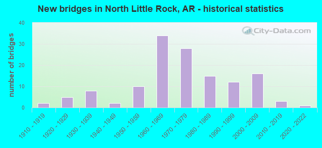
- New bridges - historical statistics
- 21910-1919
- 51920-1929
- 81930-1939
- 21940-1949
- 101950-1959
- 341960-1969
- 281970-1979
- 151980-1989
- 121990-1999
- 162000-2009
- 32010-2019
- 12020-2022
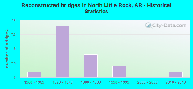
- Reconstructed bridges - Historical Statistics
- 11960-1969
- 91970-1979
- 41980-1989
- 21990-1999
- 02000-2009
- 12010-2019
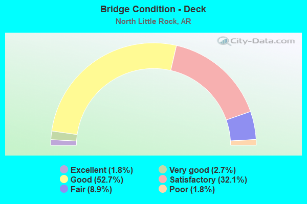
- Bridge Condition - Deck
- 1.8%Excellent
- 2.7%Very good
- 52.7%Good
- 32.1%Satisfactory
- 8.9%Fair
- 1.8%Poor
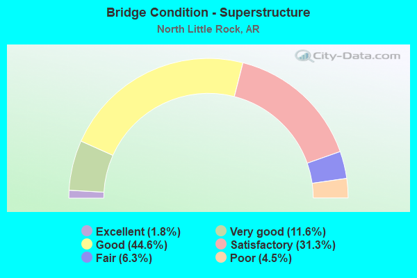
- Bridge Condition - Superstructure
- 1.8%Excellent
- 11.6%Very good
- 44.6%Good
- 31.3%Satisfactory
- 6.3%Fair
- 4.5%Poor
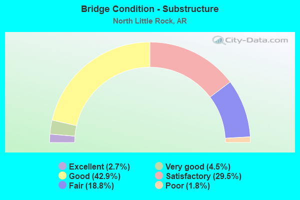
- Bridge Condition - Substructure
- 2.7%Excellent
- 4.5%Very good
- 42.9%Good
- 29.5%Satisfactory
- 18.8%Fair
- 1.8%Poor
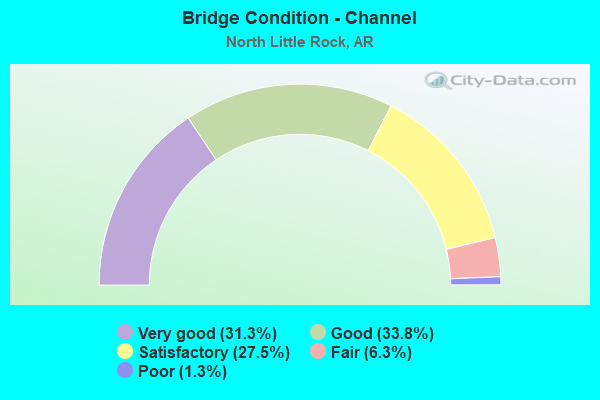
- Bridge Condition - Channel
- 31.3%Very good
- 33.8%Good
- 27.5%Satisfactory
- 6.3%Fair
- 1.3%Poor
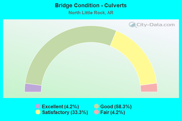
- Bridge Condition - Culverts
- 4.2%Excellent
- 58.3%Good
- 33.3%Satisfactory
- 4.2%Fair
Find on map >> Show street view
Structure Number: 6658, Location: .3 MI SO MCCAIN BLVD (Lat: 34.778739, Lng: -92.234319), Route carried "under" structure: US 67, Structure Length: 0. m, Average Daily Traffic: 41,500 (year 2014), Truck Traffic: 10%, Features Intersected: US67 SB lns
Minimum Vertical Clearance: 5.24m (17.19ft), Kilometerpoint: 0.225, Length of Maximum Span: 0.0m
Find on map >> Show street view
Structure Number: 6704, Location: I-40 LOG 142.37 (I-3) (Lat: 34.885389, Lng: -92.380250), Route carried "under" structure: Interstate 40, Structure Length: 0. m, Average Daily Traffic: 30,000 (year 2014), Truck Traffic: 1%, Features Intersected: I-40 LOG 142.37, Facility Carried by Structure: SH 365 Morgan
Minimum Vertical Clearance: 4.92m (16.14ft), Kilometerpoint: 229.122, Length of Maximum Span: 0.0m
Find on map >> Show street view
Structure Number: 6704, Location: I-40 LOG 142.37 (I-3) (Lat: 34.885389, Lng: -92.380250), Route carried "under" structure: Interstate 40, Structure Length: 0. m, Average Daily Traffic: 30,000 (year 2014), Truck Traffic: 1%, Features Intersected: I-40 LOG 142.37, Facility Carried by Structure: SH 365 Morgan
Minimum Vertical Clearance: 5.08m (16.67ft), Kilometerpoint: 229.122, Length of Maximum Span: 0.0m
Find on map >> Show street view
Structure Number: 6905, Location: I-40 Log 148.20 (Lat: 34.817050, Lng: -92.331231), Route carried "under" structure: Interstate 40, Structure Length: 0. m, Average Daily Traffic: 40,500 (year 2014), Truck Traffic: 10%, Features Intersected: I-40 Log 148.20, Facility Carried by Structure: SH 100 Log 8.67
Minimum Vertical Clearance: 5.51m (18.08ft), Kilometerpoint: 238.505, Length of Maximum Span: 0.0m
Find on map >> Show street view
Structure Number: 6905, Location: I-40 Log 148.20 (Lat: 34.817050, Lng: -92.331231), Route carried "under" structure: Interstate 40, Structure Length: 0. m, Average Daily Traffic: 40,500 (year 2014), Truck Traffic: 10%, Features Intersected: I-40 Log 148.20, Facility Carried by Structure: SH 100 Log 8.67
Minimum Vertical Clearance: 5.27m (17.29ft), Kilometerpoint: 238.505, Length of Maximum Span: 0.0m
Find on map >> Show street view
Structure Number: 6909, Location: Jct of I-40 and SH 107 (Lat: 34.780539, Lng: -92.266150), Route carried "under" structure: Interstate 40, Structure Length: 0. m, Average Daily Traffic: 43,500 (year 2014), Truck Traffic: 1%, Features Intersected: I-40 LOG 152.89, Facility Carried by Structure: SH 107, JFK Blvd.
Minimum Vertical Clearance: 5.60m (18.37ft), Kilometerpoint: 246.053, Length of Maximum Span: 0.0m
Find on map >> Show street view
Structure Number: 6909, Location: Jct of I-40 and SH 107 (Lat: 34.780539, Lng: -92.266150), Route carried "under" structure: Interstate 40, Structure Length: 0. m, Average Daily Traffic: 43,500 (year 2014), Truck Traffic: 1%, Features Intersected: I-40 LOG 152.89, Facility Carried by Structure: SH 107, JFK Blvd.
Minimum Vertical Clearance: 5.69m (18.67ft), Kilometerpoint: 246.053, Length of Maximum Span: 0.0m
Find on map >> Show street view
Structure Number: 6941, Location: 1 Mi N of I-40 (Lat: 34.790511, Lng: -92.225011), Route carried "under" structure: US 67, Structure Length: 0. m, Average Daily Traffic: 41,500 (year 2014), Truck Traffic: 1%, Features Intersected: US 67 LOG 1.20, Facility Carried by Structure: McCain Crossover
Minimum Vertical Clearance: 6.61m (21.69ft), Kilometerpoint: 1.931, Length of Maximum Span: 0.0m
Find on map >> Show street view
Structure Number: 6941, Location: 1 Mi N of I-40 (Lat: 34.790511, Lng: -92.225011), Route carried "under" structure: Ramp US 67, Structure Length: 0. m, Average Daily Traffic: 41,500 (year 2014), Truck Traffic: 1%, Features Intersected: US 67 LOG 1.20, Facility Carried by Structure: McCain Crossover
Minimum Vertical Clearance: 5.24m (17.19ft), Kilometerpoint: 1.883, Length of Maximum Span: 0.0m
Find on map >> Show street view
Structure Number: 6941, Location: 1 Mi N of I-40 (Lat: 34.790511, Lng: -92.225011), Route carried "under" structure: US 67, Structure Length: 0. m, Average Daily Traffic: 41,500 (year 2014), Truck Traffic: 1%, Features Intersected: US 67 LOG 1.20, Facility Carried by Structure: McCain Crossover
Minimum Vertical Clearance: 6.09m (19.98ft), Kilometerpoint: 1.931, Length of Maximum Span: 0.0m
Find on map >> Show street view
Structure Number: 7288, Location: 3 M E SH 107 (Lat: 34.788831, Lng: -92.204769), Route carried "under" structure: City street 737, Structure Length: 0. m, Features Intersected: Round Top Dr., Facility Carried by Structure: E. McCain Blvd
Minimum Vertical Clearance: 8.16m (26.77ft), Kilometerpoint: 0.161, Length of Maximum Span: 0.0m
Find on map >> Show street view
Structure Number: 7317, Location: 1.9 M NW SH 365 (Lat: 34.866858, Lng: -92.361314), Route carried "under" structure: Interstate 40, Structure Length: 0. m, Average Daily Traffic: 31,500 (year 2014), Truck Traffic: 10%, Features Intersected: I-40 Log 144.02, Facility Carried by Structure: CR 54 Marche Rd
Minimum Vertical Clearance: 5.10m (16.73ft), Kilometerpoint: 231.778, Length of Maximum Span: 0.0m
Find on map >> Show street view
Structure Number: 7317, Location: 1.9 M NW SH 365 (Lat: 34.866858, Lng: -92.361314), Route carried "under" structure: Interstate 40, Structure Length: 0. m, Average Daily Traffic: 31,500 (year 2014), Truck Traffic: 10%, Features Intersected: I-40 Log 144.02, Facility Carried by Structure: CR 54 Marche Rd
Minimum Vertical Clearance: 5.15m (16.90ft), Kilometerpoint: 231.778, Length of Maximum Span: 0.0m
Find on map >> Show street view
Structure Number: 7334, Location: 1.39 Mi N I-40 (Lat: 34.802139, Lng: -92.291489), Route carried "under" structure: City street 44070, Structure Length: 0. m, Features Intersected: Parkway Drive, UPPR, Facility Carried by Structure: SH 365
Minimum Vertical Clearance: 7.40m (24.28ft), Kilometerpoint: 1.722, Length of Maximum Span: 0.0m
Find on map >> Show street view
Structure Number: 19429, Location: .25 MI W I-30 (I-8) (Lat: 34.753047, Lng: -92.266075), Route carried "under" structure: City street 49137, Structure Length: 0. m, Average Daily Traffic: 2,000 (year 2014), Truck Traffic: 1%, Features Intersected: Riverfront Dr., Facility Carried by Structure: Junction Bridge
Minimum Vertical Clearance: 4.96m (16.27ft), Kilometerpoint: 1.545, Length of Maximum Span: 0.0m
Find on map >> Show street view
Structure Number: 19429, Location: .25 MI W I-30 (I-8) (Lat: 34.753047, Lng: -92.266075), Route carried "under" structure: City street 49137, Structure Length: 0. m, Average Daily Traffic: 2,000 (year 2014), Truck Traffic: 1%, Features Intersected: Riverfront Dr., Facility Carried by Structure: Junction Bridge
Minimum Vertical Clearance: 5.12m (16.80ft), Kilometerpoint: 1.545, Length of Maximum Span: 0.0m
Find on map >> Show street view
Structure Number: 19429, Location: .25 MI W I-30 (I-8) (Lat: 34.753047, Lng: -92.266075), Route carried "under" structure: Ramp City street 49137, Structure Length: 0. m, Average Daily Traffic: 2,000 (year 2014), Truck Traffic: 1%, Features Intersected: Riverfront Dr., Facility Carried by Structure: Junction Bridge
Minimum Vertical Clearance: 4.63m (15.19ft), Kilometerpoint: 1.545, Length of Maximum Span: 0.0m
Find on map >> Show street view
Structure Number: 19429, Location: .25 MI W I-30 (I-8) (Lat: 34.753047, Lng: -92.266075), Route carried "under" structure: ServiceCity street 49137, Structure Length: 0. m, Average Daily Traffic: 2,000 (year 2014), Truck Traffic: 1%, Features Intersected: Riverfront Dr., Facility Carried by Structure: Junction Bridge
Minimum Vertical Clearance: 4.75m (15.58ft), Kilometerpoint: 1.545, Length of Maximum Span: 0.0m
Find on map >> Show street view
Structure Number: A2768, Location: 1.63 MI S OF I-40/I-8 (Lat: 34.755789, Lng: -92.262350), Route carried "under" structure: US 70, Structure Length: 0. m, Average Daily Traffic: 12,000 (year 2014), Truck Traffic: 1%, Features Intersected: US 70 Broadway, Facility Carried by Structure: I-30 Log 141.17
Minimum Vertical Clearance: 7.19m (23.59ft), Kilometerpoint: 1.014, Length of Maximum Span: 0.0m
Find on map >> Show street view
Structure Number: A5706, Location: 2.6MI SO OFUS 70-(I-7) (Lat: 34.735150, Lng: -92.170300), Route carried "under" structure: US 165, Structure Length: 0. m, Average Daily Traffic: 13,000 (year 2014), Truck Traffic: 1%, Features Intersected: US 165-SEC 9, RR, Facility Carried by Structure: I 440 WB Log 7.11
Minimum Vertical Clearance: 7.34m (24.08ft), Kilometerpoint: 8.560, Length of Maximum Span: 0.0m
Find on map >> Show street view
Structure Number: A5707, Location: 2.35 SO OF I-40 (I-7) (Lat: 34.747289, Lng: -92.163050), Route carried "under" structure: County highway 82, Structure Length: 0. m, Average Daily Traffic: 664 (year 1983), Truck Traffic: 1%, Features Intersected: CR 82-FAULKNER LAKE RD, Facility Carried by Structure: I 440 WB Log 8.06
Minimum Vertical Clearance: 4.99m (16.37ft), Kilometerpoint: 2.704, Length of Maximum Span: 0.0m
Find on map >> Show street view
Structure Number: A5985, Location: Jct I-440 & I-40 (Lat: 34.780700, Lng: -92.161600), Route carried "under" structure: Ramp Interstate 40, Structure Length: 0. m, Average Daily Traffic: 16,500 (year 2014), Truck Traffic: 1%, Features Intersected: I 40-SEC 33 LOG 158.94
Minimum Vertical Clearance: 5.27m (17.29ft), Kilometerpoint: 255.805, Length of Maximum Span: 0.0m
Find on map >> Show street view
Structure Number: A5985, Location: Jct I-440 & I-40 (Lat: 34.780700, Lng: -92.161600), Route carried "under" structure: Ramp Interstate 40, Structure Length: 0. m, Average Daily Traffic: 16,500 (year 2014), Truck Traffic: 1%, Features Intersected: I 40-SEC 33 LOG 158.94
Minimum Vertical Clearance: 5.15m (16.90ft), Kilometerpoint: 255.789, Length of Maximum Span: 0.0m
Find on map >> Show street view
Structure Number: A5985, Location: Jct I-440 & I-40 (Lat: 34.780700, Lng: -92.161600), Route carried "under" structure: Interstate 40, Structure Length: 0. m, Average Daily Traffic: 16,500 (year 2014), Truck Traffic: 1%, Features Intersected: I 40-SEC 33 LOG 158.94
Minimum Vertical Clearance: 5.57m (18.27ft), Kilometerpoint: 255.789, Length of Maximum Span: 0.0m
Find on map >> Show street view
Structure Number: A5985, Location: Jct I-440 & I-40 (Lat: 34.780700, Lng: -92.161600), Route carried "under" structure: Ramp Interstate 40, Structure Length: 0. m, Average Daily Traffic: 16,500 (year 2014), Truck Traffic: 1%, Features Intersected: I 40-SEC 33 LOG 158.94
Minimum Vertical Clearance: 5.73m (18.80ft), Kilometerpoint: 255.805, Length of Maximum Span: 0.0m
Find on map >> Show street view
Structure Number: A5985, Location: Jct I-440 & I-40 (Lat: 34.780700, Lng: -92.161600), Route carried "under" structure: Interstate 40, Structure Length: 0. m, Average Daily Traffic: 16,500 (year 2014), Truck Traffic: 1%, Features Intersected: I 40-SEC 33 LOG 158.94
Minimum Vertical Clearance: 5.18m (16.99ft), Kilometerpoint: 255.789, Length of Maximum Span: 0.0m
Find on map >> Show street view
Structure Number: A6821, Location: 1.5 Mi E of SH 67 (Lat: 34.778961, Lng: -92.203981), Route carried "under" structure: State highway 161, Structure Length: 0. m, Average Daily Traffic: 4,500 (year 2014), Truck Traffic: 35%, Features Intersected: SH 161, Facility Carried by Structure: I-40 WB Log 156.50
Minimum Vertical Clearance: 5.09m (16.70ft), Kilometerpoint: 16.560, Length of Maximum Span: 0.0m
Find on map >> Show street view
Structure Number: A6821, Location: 1.5 Mi E of SH 67 (Lat: 34.778961, Lng: -92.203981), Route carried "under" structure: State highway 161, Structure Length: 0. m, Average Daily Traffic: 4,500 (year 2014), Truck Traffic: 35%, Features Intersected: SH 161, Facility Carried by Structure: I-40 WB Log 156.50
Minimum Vertical Clearance: 5.02m (16.47ft), Kilometerpoint: 16.560, Length of Maximum Span: 0.0m
Find on map >> Show street view
Structure Number: A6907, Location: 4.3 Mi S of I-430 (Lat: 34.786761, Lng: -92.288050), Route carried "under" structure: City street 59220, Structure Length: 0. m, Average Daily Traffic: 500 (year 2005), Truck Traffic: 1%, Features Intersected: Valley View Drive, Facility Carried by Structure: I-40 WB Log 151.54
Minimum Vertical Clearance: 6.55m (21.49ft), Kilometerpoint: 0.435, Length of Maximum Span: 0.0m
Find on map >> Show street view
Structure Number: A6908, Location: I-40 Log 152.02 (Lat: 34.786350, Lng: -92.279961), Route carried "under" structure: State highway 365, Structure Length: 0. m, Average Daily Traffic: 18,000 (year 2014), Truck Traffic: 4%, Features Intersected: SH 365, Pike Ave & UPRR, Facility Carried by Structure: I-40 WB 152.02 Lev
Minimum Vertical Clearance: 5.33m (17.49ft), Kilometerpoint: 24.028, Length of Maximum Span: 0.0m
Find on map >> Show street view
Structure Number: A6908, Location: I-40 Log 152.02 (Lat: 34.786350, Lng: -92.279961), Route carried "under" structure: City street 45290, Structure Length: 0. m, Average Daily Traffic: 8,200 (year 2005), Truck Traffic: 1%, Features Intersected: SH 365, Pike Ave & UPRR, Facility Carried by Structure: I-40 WB 152.02 Lev
Minimum Vertical Clearance: 15.91m (52.20ft), Kilometerpoint: 0.966, Length of Maximum Span: 0.0m
Find on map >> Show street view
Structure Number: A6908, Location: I-40 Log 152.02 (Lat: 34.786350, Lng: -92.279961), Route carried "under" structure: Ramp City street 45290, Structure Length: 0. m, Average Daily Traffic: 500 (year 2007), Truck Traffic: 1%, Features Intersected: SH 365, Pike Ave & UPRR, Facility Carried by Structure: I-40 WB 152.02 Lev
Minimum Vertical Clearance: 16.36m (53.67ft), Kilometerpoint: 0.982, Length of Maximum Span: 0.0m
Find on map >> Show street view
Structure Number: A6908, Location: I-40 Log 152.02 (Lat: 34.786350, Lng: -92.279961), Route carried "under" structure: City street 7880, Structure Length: 0. m, Average Daily Traffic: 250 (year 2007), Truck Traffic: 1%, Features Intersected: SH 365, Pike Ave & UPRR, Facility Carried by Structure: I-40 WB 152.02 Lev
Minimum Vertical Clearance: 15.84m (51.97ft), Kilometerpoint: 0.000, Length of Maximum Span: 0.0m
Find on map >> Show street view
Structure Number: B5706, Location: 2.6MI SO OF US 70(I-7) (Lat: 34.735081, Lng: -92.170119), Route carried "under" structure: US 165, Structure Length: 0. m, Average Daily Traffic: 13,000 (year 2014), Truck Traffic: 1%, Features Intersected: US 165-SEC 9,RR, Facility Carried by Structure: I 440 EB log 7.11
Minimum Vertical Clearance: 7.37m (24.18ft), Kilometerpoint: 8.544, Length of Maximum Span: 0.0m
Find on map >> Show street view
Structure Number: B5707, Location: 2.35 SO OF I 40 (I-7) (Lat: 34.747269, Lng: -92.162861), Route carried "under" structure: County highway 82, Structure Length: 0. m, Average Daily Traffic: 498 (year 1983), Truck Traffic: 1%, Features Intersected: CR 82-FAULKNER LAKE RD, Facility Carried by Structure: I-440 EB Log 8.06
Minimum Vertical Clearance: 5.48m (17.98ft), Kilometerpoint: 2.720, Length of Maximum Span: 0.0m
Find on map >> Show street view
Structure Number: B5985, Location: JCT SH440 AND I40 (I-6) (Lat: 34.780719, Lng: -92.161411), Route carried "under" structure: Ramp Interstate 40, Structure Length: 0. m, Average Daily Traffic: 16,500 (year 2014), Truck Traffic: 1%, Features Intersected: I 40 SEC 33 Log 158.94
Minimum Vertical Clearance: 5.24m (17.19ft), Kilometerpoint: 255.805, Length of Maximum Span: 0.0m
Find on map >> Show street view
Structure Number: B5985, Location: JCT SH440 AND I40 (I-6) (Lat: 34.780719, Lng: -92.161411), Route carried "under" structure: Ramp Interstate 40, Structure Length: 0. m, Average Daily Traffic: 16,500 (year 2014), Truck Traffic: 1%, Features Intersected: I 40 SEC 33 Log 158.94
Minimum Vertical Clearance: 5.94m (19.49ft), Kilometerpoint: 255.805, Length of Maximum Span: 0.0m
Find on map >> Show street view
Structure Number: B5985, Location: JCT SH440 AND I40 (I-6) (Lat: 34.780719, Lng: -92.161411), Route carried "under" structure: Interstate 40, Structure Length: 0. m, Average Daily Traffic: 16,500 (year 2014), Truck Traffic: 1%, Features Intersected: I 40 SEC 33 Log 158.94
Minimum Vertical Clearance: 5.76m (18.90ft), Kilometerpoint: 255.805, Length of Maximum Span: 0.0m
Find on map >> Show street view
Structure Number: B5985, Location: JCT SH440 AND I40 (I-6) (Lat: 34.780719, Lng: -92.161411), Route carried "under" structure: Interstate 40, Structure Length: 0. m, Average Daily Traffic: 16,500 (year 2014), Truck Traffic: 1%, Features Intersected: I 40 SEC 33 Log 158.94
Minimum Vertical Clearance: 5.33m (17.49ft), Kilometerpoint: 255.805, Length of Maximum Span: 0.0m
Find on map >> Show street view
Structure Number: B5985, Location: JCT SH440 AND I40 (I-6) (Lat: 34.780719, Lng: -92.161411), Route carried "under" structure: Ramp Interstate 40, Structure Length: 0. m, Average Daily Traffic: 16,500 (year 2014), Truck Traffic: 1%, Features Intersected: I 40 SEC 33 Log 158.94
Minimum Vertical Clearance: 5.33m (17.49ft), Kilometerpoint: 255.805, Length of Maximum Span: 0.0m
Find on map >> Show street view
Structure Number: B6821, Location: 1.5 Mi E of SH 67 (Lat: 34.778781, Lng: -92.203811), Route carried "under" structure: State highway 161, Structure Length: 0. m, Average Daily Traffic: 4,500 (year 2014), Truck Traffic: 1%, Features Intersected: SH 161, Facility Carried by Structure: I-40 EB Log 156.52
Minimum Vertical Clearance: 5.02m (16.47ft), Kilometerpoint: 16.544, Length of Maximum Span: 0.0m
Find on map >> Show street view
Structure Number: B6821, Location: 1.5 Mi E of SH 67 (Lat: 34.778781, Lng: -92.203811), Route carried "under" structure: State highway 161, Structure Length: 0. m, Average Daily Traffic: 4,500 (year 2014), Truck Traffic: 1%, Features Intersected: SH 161, Facility Carried by Structure: I-40 EB Log 156.52
Minimum Vertical Clearance: 4.99m (16.37ft), Kilometerpoint: 16.544, Length of Maximum Span: 0.0m
Find on map >> Show street view
Structure Number: B6907, Location: 4.3 Mi SE of I-430 (Lat: 34.786589, Lng: -92.288061), Route carried "under" structure: City street 59220, Structure Length: 0. m, Average Daily Traffic: 750 (year 2004), Truck Traffic: 1%, Features Intersected: Valley View Drive, Facility Carried by Structure: I-40 EB Log 151.54
Minimum Vertical Clearance: 5.30m (17.39ft), Kilometerpoint: 0.435, Length of Maximum Span: 0.0m
Find on map >> Show street view
Structure Number: B6908, Location: Jct of I-40&SH 365 @ Levy (Lat: 34.786081, Lng: -92.279689), Route carried "under" structure: State highway 365, Structure Length: 0. m, Average Daily Traffic: 18,000 (year 2014), Truck Traffic: 1%, Features Intersected: SH; 365, Pike Ave&UPRR, Facility Carried by Structure: I-40 EB Log 152.02
Minimum Vertical Clearance: 4.90m (16.08ft), Kilometerpoint: 24.044, Length of Maximum Span: 0.0m
Find on map >> Show street view
Structure Number: B6908, Location: Jct of I-40&SH 365 @ Levy (Lat: 34.786081, Lng: -92.279689), Route carried "under" structure: City street 45290, Structure Length: 0. m, Average Daily Traffic: 8,200 (year 2005), Truck Traffic: 1%, Features Intersected: SH; 365, Pike Ave&UPRR, Facility Carried by Structure: I-40 EB Log 152.02
Minimum Vertical Clearance: 16.24m (53.28ft), Kilometerpoint: 0.982, Length of Maximum Span: 0.0m
Find on map >> Show street view
Structure Number: C2768, Location: 1.4 MI SO OF I-40(I-8) (Lat: 34.759750, Lng: -92.262200), Route carried "under" structure: City street 64550, Structure Length: 0. m, Average Daily Traffic: 3,591 (year 1983), Truck Traffic: 1%, Features Intersected: Lindsey Ave. (7TH St), Facility Carried by Structure: I-30 Log 141.44
Minimum Vertical Clearance: 4.45m (14.60ft), Kilometerpoint: 0.499, Length of Maximum Span: 0.0m
Find on map >> Show street view
Structure Number: C2768, Location: 1.4 MI SO OF I-40(I-8) (Lat: 34.759750, Lng: -92.262200), Route carried "under" structure: US 70, Structure Length: 0. m, Average Daily Traffic: 12,000 (year 2014), Truck Traffic: 1%, Features Intersected: US 70 Broadway, Facility Carried by Structure: I-30 Log 141.44
Minimum Vertical Clearance: 4.60m (15.09ft), Kilometerpoint: 1.014, Length of Maximum Span: 0.0m
Find on map >> Show street view
Structure Number: D2768, Location: 1.2 MI SO OF I-40 I-8 (Lat: 34.761781, Lng: -92.262111), Route carried "under" structure: City street 64590, Structure Length: 0. m, Average Daily Traffic: 2,023 (year 1983), Truck Traffic: 1%, Features Intersected: Jones St (9TH St), Facility Carried by Structure: I-30 Log 141.58
Minimum Vertical Clearance: 4.38m (14.37ft), Kilometerpoint: 0.499, Length of Maximum Span: 0.0m
Find on map >> Show street view
Structure Number: D2768, Location: 1.2 MI SO OF I-40 I-8 (Lat: 34.761781, Lng: -92.262111), Route carried "under" structure: City street 64590, Structure Length: 0. m, Average Daily Traffic: 2,023 (year 1983), Truck Traffic: 1%, Features Intersected: Jones St (9TH St), Facility Carried by Structure: I-30 Log 141.58
Minimum Vertical Clearance: 4.54m (14.90ft), Kilometerpoint: 0.499, Length of Maximum Span: 0.0m
Find on map >> Show street view
Structure Number: F2768, Location: 1 MI SO OF I-40 (Lat: 34.765881, Lng: -92.261950), Route carried "under" structure: City street 64650, Structure Length: 0. m, Average Daily Traffic: 8,907 (year 1992), Truck Traffic: 1%, Features Intersected: E 13 STREET, Facility Carried by Structure: I-30 Log 141.86
Minimum Vertical Clearance: 4.38m (14.37ft), Kilometerpoint: 0.483, Length of Maximum Span: 0.0m
Find on map >> Show street view
Structure Number: F2768, Location: 1 MI SO OF I-40 (Lat: 34.765881, Lng: -92.261950), Route carried "under" structure: City street 64650, Structure Length: 0. m, Average Daily Traffic: 8,907 (year 1992), Truck Traffic: 1%, Features Intersected: E 13 STREET, Facility Carried by Structure: I-30 Log 141.86
Minimum Vertical Clearance: 4.57m (14.99ft), Kilometerpoint: 0.483, Length of Maximum Span: 0.0m
Find on map >> Show street view
Structure Number: G2768, Location: 0.8 MI SO OF I- 40(I-5) (Lat: 34.768089, Lng: -92.261872), Route carried "under" structure: City street 64670, Structure Length: 0. m, Average Daily Traffic: 4,948 (year 1983), Truck Traffic: 1%, Features Intersected: EAST 15TH ST Sykes, Facility Carried by Structure: I-30 Log 142.00
Minimum Vertical Clearance: 4.48m (14.70ft), Kilometerpoint: 0.499, Length of Maximum Span: 0.0m
Find on map >> Show street view
Structure Number: H2768, Location: 0.62 MI SO OF I- 40(I-5) (Lat: 34.771881, Lng: -92.261719), Route carried "under" structure: City street 64710, Structure Length: 0. m, Average Daily Traffic: 191 (year 1983), Truck Traffic: 1%, Features Intersected: EAST 19TH STREET, Facility Carried by Structure: I-30 Log 142.28
Minimum Vertical Clearance: 4.51m (14.80ft), Kilometerpoint: 0.499, Length of Maximum Span: 0.0m
Find on map >> Show street view
Structure Number: K2768, Location: 1.8 MI SO OF I- 40(I-8) (Lat: 34.753869, Lng: -92.262450), Route carried "under" structure: City street 60841, Structure Length: 0. m, Average Daily Traffic: 1,147 (year 1983), Truck Traffic: 1%, Features Intersected: WASHINGTON AVE NLR, Facility Carried by Structure: I-30 Log 141.03
Minimum Vertical Clearance: 4.48m (14.70ft), Kilometerpoint: 0.515, Length of Maximum Span: 0.0m