Bridge Statistics for Philadelphia, Pennsylvania (PA)
Condition, Traffic, Stress, Structural Evaluation, Project Costs
- National Bridge Inventory (NBI) Statistics
- 1,227Number of bridges
- 25,561ft / 7,791mTotal length
- $1,156,795,000Total costs
- 32,975,097Total average daily traffic
- 2,105,575Total average daily truck traffic
- National Bridge Inventory (NBI) Registered Bridges for Philadelphia
- No street view available for this location
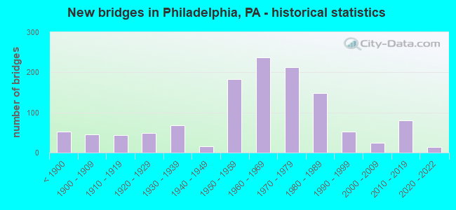
- New bridges - historical statistics
- 53Before 1900
- 451900-1909
- 431910-1919
- 481920-1929
- 681930-1939
- 151940-1949
- 1831950-1959
- 2381960-1969
- 2131970-1979
- 1491980-1989
- 531990-1999
- 252000-2009
- 802010-2019
- 142020-2022
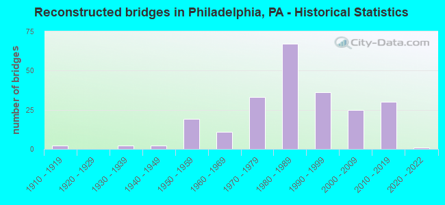
- Reconstructed bridges - Historical Statistics
- 21910-1919
- 01920-1929
- 21930-1939
- 21940-1949
- 191950-1959
- 111960-1969
- 331970-1979
- 671980-1989
- 361990-1999
- 252000-2009
- 302010-2019
- 12020-2022
- Bridge Condition - Deck
- 1.0%Excellent
- 11.5%Very good
- 24.4%Good
- 34.4%Satisfactory
- 21.9%Fair
- 6.0%Poor
- 0.9%Serious
- Bridge Condition - Superstructure
- 1.5%Excellent
- 11.3%Very good
- 18.7%Good
- 32.9%Satisfactory
- 26.6%Fair
- 7.5%Poor
- 1.2%Serious
- 0.3%Imminent failure
- 0.2%Failed
- Bridge Condition - Substructure
- 6.5%Excellent
- 18.9%Very good
- 34.6%Good
- 30.3%Satisfactory
- 7.9%Fair
- 1.1%Poor
- 0.8%Serious
- 0.2%Critical
- Bridge Condition - Channel
- 1.5%Excellent
- 4.0%Very good
- 16.1%Good
- 23.6%Satisfactory
- 34.2%Fair
- 19.6%Poor
- 1.0%Serious
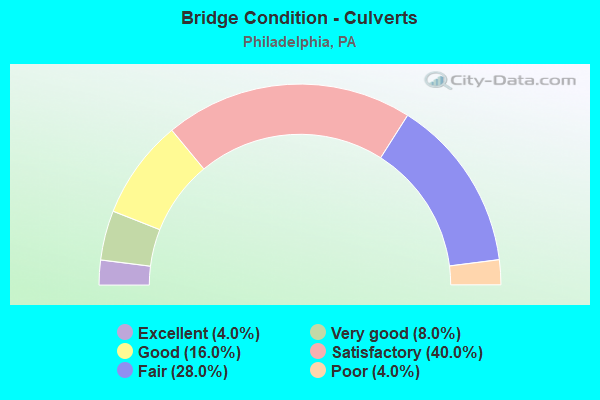
- Bridge Condition - Culverts
- 3.3%Excellent
- 6.7%Very good
- 20.0%Good
- 43.3%Satisfactory
- 23.3%Fair
- 3.3%Poor
Find on map >> Show street view
Structure Number: 38999, Location: .5MI.W.OF I-676 3589H10 (Lat: 39.941111, Lng: -75.205833), Route carried "on" structure: State highway , Year Built: 1976, Status: Open, Structure Length: 45.17m (148.20ft), Average Daily Traffic: 20,954 (year 2022), Truck Traffic: 12%, Average Future Daily Traffic: 24,233 (year 2032), Design Load: HS 20, Features Intersected: SCHUYLKILL RIV;AMTRAK, Facility Carried by Structure: GRAYS FERRY AVENUE
Minimum Vertical Clearance: 30+ m (98+ ft), Kilometerpoint: 4.543, Lanes on structure: 4, Owner: State Highway Agency, Approaching Roadway Width: 19.2m (63.0ft), Skew: 39 degrees, Navigation Control: Yes ( Vertical Clearance: 999.7m (3,279.9ft), Horizontal Clearance: 9999.9m (32,808.1ft)), Material/Design: Steel continuous, Design/Construction: Stringer/Multi-beam, Number Of Spans In Main Unit: 12, Length of Maximum Span: 56.4m (185.0ft), Curb or Sidewalk Widths: Left: 1.5m (4.9ft), Right: 0.2m (0.7ft), Curb-To-Curb Width: 23.0m (75.5ft), Out-to-Out Width: 26.5m (86.9ft)
Condition: Deck: Satisfactory, Superstructure: Satisfactory, Substructure: Fair, Channel: Satisfactory, Operating Rating: 60.8 metric tons, Method Used To Determine Operating Rating: Load Factor (LF), Inventory Rating: 36.3 metric tons, Method Used To Determine Inventory Rating: Load Factor (LF), Structural Evaluation: Somewhat better than minimum adequacy, Deck Geometry: Superior to present desirable criteria, Underclear: High priority of corrective action, Waterway Adequacy: Superior to present desirable criteria, Approach Roadway Alignment: Better than present minimum criteria, Length Of Structure Improvement: 49.30m (161.75ft), Designated Inspection Frequency: Every 24 months, Critical Feature Inspection Frequency: Every 24 months, Underwater Inspection Frequency: Every 60 months, Inspection Date: July 2020, Critical Feature Inspection Date: July 2020, Underwater Inspection Date: June 2019, Bridge Improvement Cost: $1,511,000, Roadway Improvement Cost: $4,449,000, Total Project Cost: $20,393,000, Deck Structure Type: Concrete Cast-file-Place, Wearing Surface/Protective System: Wearing Surface: Monolithic Concrete
Find on map >> Show street view
Structure Number: 39, Location: SW.PHILA 3699A2 (Lat: 39.929606, Lng: -75.243925), Route carried "on" structure: State highway , Year Built: 1906, Status: Open, Structure Length: 1.40m (4.59ft), Average Daily Traffic: 5,527 (year 2022), Truck Traffic: 5%, Average Future Daily Traffic: 8,794 (year 2032), Design Load: H 20, Features Intersected: COBBS CREEK, Facility Carried by Structure: 65TH STREET
Minimum Vertical Clearance: 30+ m (98+ ft), Kilometerpoint: 0.000, Lanes on structure: 2, Owner: State Highway Agency, Approaching Roadway Width: 11.0m (36.1ft), Skew: 1 degrees, Material/Design: Concrete, Design/Construction: Arch - Deck, Number Of Spans In Main Unit: 1, Length of Maximum Span: 14.0m (45.9ft), Curb-To-Curb Width: 10.9m (35.8ft), Out-to-Out Width: 11.6m (38.1ft)
Condition: Superstructure: Poor, Substructure: Poor, Channel: Poor, Operating Rating: 49.9 metric tons, Method Used To Determine Operating Rating: Field evaluation and documented engineering judgment, Inventory Rating: 24.5 metric tons, Method Used To Determine Inventory Rating: Field evaluation and documented engineering judgment, Structural Evaluation: Meets minimum limits, Deck Geometry: Meets minimum limits, Waterway Adequacy: Superior to present desirable criteria, Approach Roadway Alignment: Equal to present desirable criteria, Length Of Structure Improvement: 2.20m (7.22ft), Designated Inspection Frequency: Every 24 months, Underwater Inspection Frequency: Every 24 months, Inspection Date: May 2020, Underwater Inspection Date: May 2020, Bridge Improvement Cost: $11,000, Roadway Improvement Cost: $34,000, Total Project Cost: $153,000
Find on map >> Show street view
Structure Number: 39001, Location: SW.PHILADELPHIA 3699A02 (Lat: 39.929508, Lng: -75.243383), Route carried "on" structure: State highway , Year Built: 1926, Status: Open, Structure Length: 3.23m (10.60ft), Average Daily Traffic: 5,527 (year 2022), Truck Traffic: 5%, Average Future Daily Traffic: 8,794 (year 2032), Design Load: H 20, Features Intersected: COBBS CREEK PARKWAY, Facility Carried by Structure: 65TH STREET
Minimum Vertical Clearance: 30+ m (98+ ft), Kilometerpoint: 0.000, Lanes on structure: 2, Lanes under structure: 2, Owner: State Highway Agency, Approaching Roadway Width: 11.0m (36.1ft), Skew: 1 degrees, Material/Design: Concrete continuous, Design/Construction: Stringer/Multi-beam, Number Of Spans In Main Unit: 2, Length of Maximum Span: 15.8m (51.8ft), Curb or Sidewalk Widths: Left: 3.0m (9.8ft), Right: 3.0m (9.8ft), Curb-To-Curb Width: 11.0m (36.1ft), Out-to-Out Width: 18.3m (60.0ft)
Condition: Deck: Fair, Superstructure: Fair, Substructure: Fair, Operating Rating: 80.7 metric tons, Method Used To Determine Operating Rating: Load Factor (LF), Inventory Rating: 48.1 metric tons, Method Used To Determine Inventory Rating: Load Factor (LF), Structural Evaluation: Somewhat better than minimum adequacy, Deck Geometry: Meets minimum limits, Underclear: Equal to present minimum criteria, Approach Roadway Alignment: Equal to present desirable criteria, Length Of Structure Improvement: 3.90m (12.80ft), Designated Inspection Frequency: Every 24 months, Inspection Date: April 2020, Bridge Improvement Cost: $77,000, Roadway Improvement Cost: $228,000, Total Project Cost: $1,044,000, Wearing Surface/Protective System: Wearing Surface: Bituminous
Find on map >> Show street view
Structure Number: 39003, Location: NEAR 58TH STREET 3699E02 (Lat: 39.925711, Lng: -75.220861), Route carried "on" structure: State highway , Year Built: 1983, Status: Open, Structure Length: 1.22m (4.00ft), Average Daily Traffic: 15,756 (year 2022), Truck Traffic: 7%, Average Future Daily Traffic: 23,034 (year 2032), Design Load: HS 20, Features Intersected: SEPTA AIRPORT H S LINE, Facility Carried by Structure: LINDBERGH BLVD.
Minimum Vertical Clearance: 30+ m (98+ ft), Kilometerpoint: 0.584, Lanes on structure: 4, Owner: State Highway Agency, Approaching Roadway Width: 20.4m (66.9ft), Skew: 30 degrees, Material/Design: Prestressed concrete, Design/Construction: Box Beam or Girders - Multiple, Number Of Spans In Main Unit: 1, Length of Maximum Span: 12.2m (40.0ft), Curb or Sidewalk Widths: Left: 3.4m (11.2ft), Right: 3.4m (11.2ft), Curb-To-Curb Width: 20.4m (66.9ft), Out-to-Out Width: 40.2m (131.9ft)
Condition: Deck: Good, Superstructure: Good, Substructure: Good, Operating Rating: 95.3 metric tons, Method Used To Determine Operating Rating: Load Factor (LF), Inventory Rating: 49.0 metric tons, Method Used To Determine Inventory Rating: Load Factor (LF), Structural Evaluation: Better than present minimum criteria, Deck Geometry: Superior to present desirable criteria, Underclear: High priority of corrective action, Approach Roadway Alignment: Equal to present desirable criteria, Length Of Structure Improvement: 2.00m (6.56ft), Designated Inspection Frequency: Every 24 months, Inspection Date: June 2020, Deck Structure Type: Concrete Cast-file-Place, Wearing Surface/Protective System: Wearing Surface: Monolithic Concrete, Deck Protection: Epoxy Coated Reinforcing
Find on map >> Show street view
Structure Number: 39004, Location: 30TH STR.STATION W3590A08 (Lat: 39.954444, Lng: -75.181111), Route carried "on" structure: State highway , Year Built: 1930, Status: Open, Structure Length: 6.13m (20.11ft), Average Daily Traffic: 20,159 (year 2022), Truck Traffic: 5%, Average Future Daily Traffic: 32,975 (year 2032), Design Load: H 20, Features Intersected: AMTRAK, Facility Carried by Structure: 30TH STREET
Minimum Vertical Clearance: 30+ m (98+ ft), Kilometerpoint: 0.000, Lanes on structure: 3, Base Highway Network: Yes, Owner: State Highway Agency, Approaching Roadway Width: 12.5m (41.0ft), Skew: 9 degrees, Material/Design: Steel, Design/Construction: Girder and Floorbeam System, Number Of Spans In Main Unit: 9, Length of Maximum Span: 9.4m (30.8ft), Curb or Sidewalk Widths: Left: 1.5m (4.9ft), Right: 5.2m (17.1ft), Curb-To-Curb Width: 12.5m (41.0ft), Out-to-Out Width: 22.9m (75.1ft)
Condition: Deck: Fair, Superstructure: Satisfactory, Substructure: Fair, Operating Rating: 63.5 metric tons, Method Used To Determine Operating Rating: Load Factor (LF), Inventory Rating: 38.1 metric tons, Method Used To Determine Inventory Rating: Load Factor (LF), Structural Evaluation: Somewhat better than minimum adequacy, Deck Geometry: Meets minimum limits, Underclear: High priority of corrective action, Approach Roadway Alignment: Equal to present desirable criteria, Length Of Structure Improvement: 7.00m (22.97ft), Designated Inspection Frequency: Every 24 months, Critical Feature Inspection Frequency: Every 24 months, Other Special Inspection Frequency: Every 12 months, Inspection Date: August 2020, Critical Feature Inspection Date: August 2020, Other Special Inspection Date: August 2020, Bridge Improvement Cost: $189,000, Roadway Improvement Cost: $555,000, Total Project Cost: $2,546,000, Deck Structure Type: Concrete Cast-file-Place, Wearing Surface/Protective System: Wearing Surface: Bituminous, Membrane: Other
Find on map >> Show street view
Structure Number: 39005, Location: 30TH;MARKET ST 3590A08 (Lat: 39.955000, Lng: -75.183333), Route carried "on" structure: State highway , Year Built: 1932, Status: Open, Structure Length: 19.29m (63.29ft), Average Daily Traffic: 19,254 (year 2022), Truck Traffic: 4%, Average Future Daily Traffic: 21,731 (year 2032), Design Load: H 20, Features Intersected: AMTRAK, Facility Carried by Structure: LITTLE MARKET ST
Minimum Vertical Clearance: 30+ m (98+ ft), Kilometerpoint: 0.000, Lanes on structure: 2, Base Highway Network: Yes, Owner: State Highway Agency, Approaching Roadway Width: 18.3m (60.0ft), Skew: 30 degrees, Material/Design: Steel, Design/Construction: Girder and Floorbeam System, Number Of Spans In Main Unit: 23, Length of Maximum Span: 8.5m (27.9ft), Curb or Sidewalk Widths: Left: 4.4m (14.4ft), Right: 0.2m (0.7ft), Curb-To-Curb Width: 19.5m (64.0ft), Out-to-Out Width: 28.3m (92.8ft)
Condition: Deck: Satisfactory, Superstructure: Satisfactory, Substructure: Fair, Operating Rating: 66.2 metric tons, Method Used To Determine Operating Rating: Field evaluation and documented engineering judgment, Inventory Rating: 39.9 metric tons, Method Used To Determine Inventory Rating: Field evaluation and documented engineering judgment, Structural Evaluation: Somewhat better than minimum adequacy, Deck Geometry: Superior to present desirable criteria, Underclear: High priority of corrective action, Approach Roadway Alignment: Better than present minimum criteria, Length Of Structure Improvement: 19.10m (62.66ft), Designated Inspection Frequency: Every 24 months, Critical Feature Inspection Frequency: Every 24 months, Inspection Date: August 2020, Critical Feature Inspection Date: August 2020, Bridge Improvement Cost: $58,000, Roadway Improvement Cost: $170,000, Total Project Cost: $780,000, Deck Structure Type: Concrete Cast-file-Place, Wearing Surface/Protective System: Wearing Surface: Bituminous
Find on map >> Show street view
Structure Number: 39006, Location: VINE STR.EXPWAY. 3590D07 (Lat: 39.958056, Lng: -75.165556), Route carried "on" structure: State highway , Year Built: 1989, Status: Open, Structure Length: 1.74m (5.71ft), Average Daily Traffic: 11,262 (year 2022), Truck Traffic: 3%, Average Future Daily Traffic: 20,725 (year 2032), Design Load: HS 25 or greater, Features Intersected: RAMP EB-15 OFF, Facility Carried by Structure: 16TH STREET
Minimum Vertical Clearance: 30+ m (98+ ft), Kilometerpoint: 0.000, Lanes on structure: 4, Lanes under structure: 2, Owner: State Highway Agency, Approaching Roadway Width: 14.0m (45.9ft), Material/Design: Steel, Design/Construction: Stringer/Multi-beam, Number Of Spans In Main Unit: 1, Length of Maximum Span: 16.8m (55.1ft), Curb or Sidewalk Widths: Left: 5.5m (18.0ft), Right: 3.7m (12.1ft), Curb-To-Curb Width: 14.0m (45.9ft), Out-to-Out Width: 23.5m (77.1ft)
Condition: Deck: Good, Superstructure: Good, Substructure: Good, Operating Rating: 61.7 metric tons, Method Used To Determine Operating Rating: Load Factor (LF), Inventory Rating: 37.2 metric tons, Method Used To Determine Inventory Rating: Load Factor (LF), Structural Evaluation: Better than present minimum criteria, Deck Geometry: High priority of replacement, Underclear: High priority of corrective action, Approach Roadway Alignment: Equal to present desirable criteria, Length Of Structure Improvement: 2.70m (8.86ft), Designated Inspection Frequency: Every 24 months, Inspection Date: May 2020, Deck Structure Type: Concrete Cast-file-Place, Wearing Surface/Protective System: Wearing Surface: Bituminous, Deck Protection: Epoxy Coated Reinforcing
Find on map >> Show street view
Structure Number: 39007, Location: VINE STREET EXWY. 3590D07 (Lat: 39.958333, Lng: -75.166667), Route carried "on" structure: State highway , Year Built: 1990, Status: Open, Structure Length: 3.78m (12.40ft), Average Daily Traffic: 11,262 (year 2022), Truck Traffic: 3%, Average Future Daily Traffic: 20,725 (year 2032), Design Load: HS 25 or greater, Features Intersected: VINE STR;RAMP 16V, Facility Carried by Structure: 16TH STREET
Minimum Vertical Clearance: 30+ m (98+ ft), Kilometerpoint: 0.000, Lanes on structure: 3, Lanes under structure: 6, Owner: State Highway Agency, Approaching Roadway Width: 10.7m (35.1ft), Material/Design: Steel, Design/Construction: Stringer/Multi-beam, Number Of Spans In Main Unit: 1, Length of Maximum Span: 36.6m (120.1ft), Curb or Sidewalk Widths: Left: 3.7m (12.1ft), Right: 3.7m (12.1ft), Curb-To-Curb Width: 10.7m (35.1ft), Out-to-Out Width: 23.6m (77.4ft)
Condition: Deck: Good, Superstructure: Satisfactory, Substructure: Good, Operating Rating: 94.3 metric tons, Method Used To Determine Operating Rating: Load Factor (LF), Inventory Rating: 56.2 metric tons, Method Used To Determine Inventory Rating: Load Factor (LF), Structural Evaluation: Equal to present minimum criteria, Deck Geometry: High priority of replacement, Underclear: High priority of corrective action, Approach Roadway Alignment: Equal to present desirable criteria, Length Of Structure Improvement: 4.70m (15.42ft), Designated Inspection Frequency: Every 24 months, Inspection Date: May 2020, Deck Structure Type: Concrete Cast-file-Place, Wearing Surface/Protective System: Wearing Surface: Bituminous, Deck Protection: Epoxy Coated Reinforcing
Find on map >> Show street view
Structure Number: 39009, Location: NR.30TH STR.STA. 3590A08 (Lat: 39.955556, Lng: -75.186944), Route carried "on" structure: State highway , Year Built: 1955, Status: Open, Structure Length: 4.42m (14.50ft), Average Daily Traffic: 9,561 (year 2022), Truck Traffic: 14%, Average Future Daily Traffic: 9,431 (year 2032), Design Load: HS 20, Features Intersected: AMTRAK(NY BRANCH);ROAD, Facility Carried by Structure: JFK BLVD.AT 30TH
Minimum Vertical Clearance: 30+ m (98+ ft), Kilometerpoint: 0.000, Lanes on structure: 2, Lanes under structure: 2, Base Highway Network: Yes, Owner: State Highway Agency, Approaching Roadway Width: 17.1m (56.1ft), Skew: 22 degrees, Material/Design: Steel, Design/Construction: Stringer/Multi-beam, Number Of Spans In Main Unit: 5, Length of Maximum Span: 18.9m (62.0ft), Curb or Sidewalk Widths: Left: 6.2m (20.3ft), Right: 6.8m (22.3ft), Curb-To-Curb Width: 16.5m (54.1ft), Out-to-Out Width: 29.7m (97.4ft)
Condition: Deck: Satisfactory, Superstructure: Fair, Substructure: Fair, Operating Rating: 58.1 metric tons, Method Used To Determine Operating Rating: Load Factor (LF), Inventory Rating: 34.5 metric tons, Method Used To Determine Inventory Rating: Load Factor (LF), Structural Evaluation: Somewhat better than minimum adequacy, Deck Geometry: Superior to present desirable criteria, Underclear: Meets minimum limits, Approach Roadway Alignment: Equal to present minimum criteria, Length Of Structure Improvement: 16.00m (52.49ft), Designated Inspection Frequency: Every 24 months, Critical Feature Inspection Frequency: Every 24 months, Inspection Date: October 2020, Critical Feature Inspection Date: October 2020, Bridge Improvement Cost: $113,000, Roadway Improvement Cost: $334,000, Total Project Cost: $1,529,000, Deck Structure Type: Concrete Cast-file-Place, Wearing Surface/Protective System: Wearing Surface: Bituminous
Find on map >> Show street view
Structure Number: 39011, Location: W.OF 30TH ST.STA. 3590A07 (Lat: 39.955556, Lng: -75.186944), Route carried "on" structure: State highway , Year Built: 1955, Year Reconstructed: 2021, Status: Open, Structure Length: 1.34m (4.40ft), Average Daily Traffic: 9,561 (year 2022), Truck Traffic: 14%, Average Future Daily Traffic: 9,431 (year 2032), Design Load: HS 20, Features Intersected: SEPTA (WEST BRANCH), Facility Carried by Structure: KENNEDY BLVD AT 32
Minimum Vertical Clearance: 30+ m (98+ ft), Kilometerpoint: 0.000, Lanes on structure: 4, Base Highway Network: Yes, Owner: State Highway Agency, Approaching Roadway Width: 16.5m (54.1ft), Skew: 22 degrees, Material/Design: Steel, Design/Construction: Stringer/Multi-beam, Number Of Spans In Main Unit: 2, Length of Maximum Span: 10.7m (35.1ft), Curb or Sidewalk Widths: Left: 6.4m (21.0ft), Right: 5.5m (18.0ft), Curb-To-Curb Width: 16.5m (54.1ft), Out-to-Out Width: 28.9m (94.8ft)
Condition: Deck: Satisfactory, Superstructure: Satisfactory, Substructure: Satisfactory, Operating Rating: 44.5 metric tons, Method Used To Determine Operating Rating: Assigned ratings based on Load and Resistance Factor Design (LRFD) reported in metric tons, Inventory Rating: 26.3 metric tons, Method Used To Determine Inventory Rating: Assigned ratings based on Load and Resistance Factor Design (LRFD) reported in metric tons, Structural Evaluation: Equal to present minimum criteria, Deck Geometry: Meets minimum limits, Underclear: High priority of corrective action, Approach Roadway Alignment: Equal to present minimum criteria, Length Of Structure Improvement: 2.00m (6.56ft), Designated Inspection Frequency: Every 24 months, Critical Feature Inspection Frequency: Every 24 months, Inspection Date: August 2020, Critical Feature Inspection Date: August 2021, Bridge Improvement Cost: $14,000, Roadway Improvement Cost: $40,000, Total Project Cost: $186,000, Deck Structure Type: Concrete Cast-file-Place, Wearing Surface/Protective System: Wearing Surface: Bituminous
Find on map >> Show street view
Structure Number: 39012, Location: VINE ST.EXPRESSWAY3590D07 (Lat: 39.958094, Lng: -75.164106), Route carried "on" structure: State highway , Year Built: 1989, Status: Open, Structure Length: 3.75m (12.30ft), Average Daily Traffic: 33,991 (year 2022), Truck Traffic: 5%, Average Future Daily Traffic: 46,265 (year 2032), Design Load: HS 25 or greater, Features Intersected: VINE STR;RAMP V-15-W, Facility Carried by Structure: 15TH STREET
Minimum Vertical Clearance: 30+ m (98+ ft), Kilometerpoint: 0.000, Lanes on structure: 3, Lanes under structure: 5, Owner: State Highway Agency, Approaching Roadway Width: 14.0m (45.9ft), Material/Design: Steel, Design/Construction: Stringer/Multi-beam, Number Of Spans In Main Unit: 1, Length of Maximum Span: 36.0m (118.1ft), Curb or Sidewalk Widths: Left: 3.7m (12.1ft), Right: 3.7m (12.1ft), Curb-To-Curb Width: 14.0m (45.9ft), Out-to-Out Width: 27.0m (88.6ft)
Condition: Deck: Satisfactory, Superstructure: Good, Substructure: Good, Operating Rating: 73.5 metric tons, Method Used To Determine Operating Rating: Load Factor (LF), Inventory Rating: 44.5 metric tons, Method Used To Determine Inventory Rating: Load Factor (LF), Structural Evaluation: Better than present minimum criteria, Deck Geometry: Somewhat better than minimum adequacy, Underclear: High priority of corrective action, Approach Roadway Alignment: Equal to present desirable criteria, Length Of Structure Improvement: 4.70m (15.42ft), Designated Inspection Frequency: Every 24 months, Critical Feature Inspection Frequency: Every 24 months, Inspection Date: May 2020, Critical Feature Inspection Date: May 2020, Deck Structure Type: Concrete Cast-file-Place, Wearing Surface/Protective System: Wearing Surface: Bituminous, Deck Protection: Epoxy Coated Reinforcing
Find on map >> Show street view
Structure Number: 39014, Location: IN CENTER CITY 3590 B08 (Lat: 39.954772, Lng: -75.174856), Route carried "on" structure: State highway , Year Built: 1957, Year Reconstructed: 2018, Status: Open, Structure Length: 1.65m (5.41ft), Average Daily Traffic: 12,812 (year 2022), Truck Traffic: 2%, Average Future Daily Traffic: 13,961 (year 2032), Design Load: HL 93, Features Intersected: 21ST STREET, Facility Carried by Structure: JFK BLVD.
Minimum Vertical Clearance: 30+ m (98+ ft), Kilometerpoint: 0.000, Lanes on structure: 3, Lanes under structure: 2, Base Highway Network: Yes, Owner: State Highway Agency, Approaching Roadway Width: 12.2m (40.0ft), Skew: 30 degrees, Material/Design: Prestressed concrete, Design/Construction: Stringer/Multi-beam, Number Of Spans In Main Unit: 1, Length of Maximum Span: 15.8m (51.8ft), Curb or Sidewalk Widths: Left: 4.8m (15.7ft), Right: 6.6m (21.7ft), Curb-To-Curb Width: 11.6m (38.1ft), Out-to-Out Width: 24.5m (80.4ft)
Condition: Deck: Very good, Superstructure: Excellent, Substructure: Good, Operating Rating: 49.2 metric tons, Method Used To Determine Operating Rating: Assigned ratings based on Load and Resistance Factor Design (LRFD) reported by rating factor (RF) using HL93 loadings, Inventory Rating: 38.2 metric tons, Method Used To Determine Inventory Rating: Assigned ratings based on Load and Resistance Factor Design (LRFD) reported by rating factor (RF) using HL93 loadings, Structural Evaluation: Better than present minimum criteria, Deck Geometry: High priority of replacement, Underclear: Superior to present desirable criteria, Approach Roadway Alignment: Equal to present desirable criteria, Length Of Structure Improvement: 2.30m (7.55ft), Designated Inspection Frequency: Every 24 months, Inspection Date: November 2020, Bridge Improvement Cost: $54,000, Roadway Improvement Cost: $159,000, Total Project Cost: $729,000, Deck Structure Type: Concrete Cast-file-Place, Wearing Surface/Protective System: Wearing Surface: Monolithic Concrete, Deck Protection: Epoxy Coated Reinforcing
Find on map >> Show street view
Structure Number: 39015, Location: IN CENTER CITY 3590B08 (Lat: 39.954969, Lng: -75.176433), Route carried "on" structure: State highway , Year Built: 1957, Year Reconstructed: 2018, Status: Open, Structure Length: 1.95m (6.40ft), Average Daily Traffic: 12,812 (year 2022), Truck Traffic: 2%, Average Future Daily Traffic: 13,961 (year 2032), Design Load: HL 93, Features Intersected: 22ND STREET, Facility Carried by Structure: JFK BLVD.
Minimum Vertical Clearance: 30+ m (98+ ft), Kilometerpoint: 0.000, Lanes on structure: 3, Lanes under structure: 2, Base Highway Network: Yes, Owner: State Highway Agency, Approaching Roadway Width: 12.2m (40.0ft), Skew: 30 degrees, Material/Design: Prestressed concrete, Design/Construction: Stringer/Multi-beam, Number Of Spans In Main Unit: 1, Length of Maximum Span: 18.9m (62.0ft), Curb or Sidewalk Widths: Left: 4.8m (15.7ft), Right: 6.6m (21.7ft), Curb-To-Curb Width: 11.6m (38.1ft), Out-to-Out Width: 24.5m (80.4ft)
Condition: Deck: Very good, Superstructure: Excellent, Substructure: Good, Operating Rating: 50.2 metric tons, Method Used To Determine Operating Rating: Assigned ratings based on Load and Resistance Factor Design (LRFD) reported by rating factor (RF) using HL93 loadings, Inventory Rating: 38.9 metric tons, Method Used To Determine Inventory Rating: Assigned ratings based on Load and Resistance Factor Design (LRFD) reported by rating factor (RF) using HL93 loadings, Structural Evaluation: Better than present minimum criteria, Deck Geometry: High priority of replacement, Underclear: Superior to present desirable criteria, Approach Roadway Alignment: Equal to present desirable criteria, Length Of Structure Improvement: 2.50m (8.20ft), Designated Inspection Frequency: Every 24 months, Inspection Date: November 2020, Bridge Improvement Cost: $54,000, Roadway Improvement Cost: $159,000, Total Project Cost: $729,000, Deck Structure Type: Concrete Cast-file-Place, Wearing Surface/Protective System: Wearing Surface: Monolithic Concrete, Deck Protection: Epoxy Coated Reinforcing
Find on map >> Show street view
Structure Number: 39016, Location: IN CENTER CITY 3590B08 (Lat: 39.955117, Lng: -75.177586), Route carried "on" structure: State highway , Year Built: 1957, Year Reconstructed: 2018, Status: Open, Structure Length: 1.65m (5.41ft), Average Daily Traffic: 12,812 (year 2022), Truck Traffic: 2%, Average Future Daily Traffic: 13,961 (year 2032), Design Load: HL 93, Features Intersected: 23RD STREET, Facility Carried by Structure: JFK BLVD.
Minimum Vertical Clearance: 30+ m (98+ ft), Kilometerpoint: 0.000, Lanes on structure: 3, Lanes under structure: 2, Base Highway Network: Yes, Owner: State Highway Agency, Approaching Roadway Width: 15.2m (49.9ft), Skew: 30 degrees, Material/Design: Prestressed concrete, Design/Construction: Stringer/Multi-beam, Number Of Spans In Main Unit: 1, Length of Maximum Span: 15.8m (51.8ft), Curb or Sidewalk Widths: Left: 4.8m (15.7ft), Right: 6.6m (21.7ft), Curb-To-Curb Width: 11.6m (38.1ft), Out-to-Out Width: 24.5m (80.4ft)
Condition: Deck: Very good, Superstructure: Excellent, Substructure: Good, Operating Rating: 49.2 metric tons, Method Used To Determine Operating Rating: Assigned ratings based on Load and Resistance Factor Design (LRFD) reported by rating factor (RF) using HL93 loadings, Inventory Rating: 38.2 metric tons, Method Used To Determine Inventory Rating: Assigned ratings based on Load and Resistance Factor Design (LRFD) reported by rating factor (RF) using HL93 loadings, Structural Evaluation: Better than present minimum criteria, Deck Geometry: High priority of replacement, Underclear: Superior to present desirable criteria, Approach Roadway Alignment: Equal to present desirable criteria, Length Of Structure Improvement: 2.30m (7.55ft), Designated Inspection Frequency: Every 24 months, Inspection Date: November 2020, Bridge Improvement Cost: $49,000, Roadway Improvement Cost: $143,000, Total Project Cost: $657,000, Deck Structure Type: Concrete Cast-file-Place, Wearing Surface/Protective System: Wearing Surface: Monolithic Concrete, Deck Protection: Epoxy Coated Reinforcing
Find on map >> Show street view
Structure Number: 39017, Location: 30TH STREET STA. 3590B08 (Lat: 39.955408, Lng: -75.179928), Route carried "on" structure: State highway , Year Built: 1959, Year Reconstructed: 2009, Status: Open, Structure Length: 14.87m (48.79ft), Average Daily Traffic: 12,812 (year 2022), Truck Traffic: 2%, Average Future Daily Traffic: 13,961 (year 2032), Design Load: HS 20, Features Intersected: SCHUYLKILL RIVER;CSX RR, Facility Carried by Structure: JFK BLVD.
Minimum Vertical Clearance: 30+ m (98+ ft), Kilometerpoint: 0.000, Lanes on structure: 4, Base Highway Network: Yes, Owner: State Highway Agency, Approaching Roadway Width: 16.8m (55.1ft), Skew: 30 degrees, Material/Design: Steel continuous, Design/Construction: Girder and Floorbeam System, Number Of Spans In Main Unit: 2, Number Of Approach Spans: 1, Length of Maximum Span: 56.4m (185.0ft), Curb or Sidewalk Widths: Left: 3.7m (12.1ft), Right: 6.4m (21.0ft), Curb-To-Curb Width: 14.6m (47.9ft), Out-to-Out Width: 24.4m (80.1ft)
Condition: Deck: Good, Superstructure: Satisfactory, Substructure: Satisfactory, Channel: Satisfactory, Operating Rating: 67.1 metric tons, Method Used To Determine Operating Rating: Load Factor (LF), Inventory Rating: 39.9 metric tons, Method Used To Determine Inventory Rating: Load Factor (LF), Structural Evaluation: Equal to present minimum criteria, Deck Geometry: High priority of replacement, Underclear: High priority of corrective action, Waterway Adequacy: Superior to present desirable criteria, Approach Roadway Alignment: Equal to present desirable criteria, Length Of Structure Improvement: 15.80m (51.84ft), Designated Inspection Frequency: Every 24 months, Critical Feature Inspection Frequency: Every 24 months, Underwater Inspection Frequency: Every 60 months, Inspection Date: September 2021, Critical Feature Inspection Date: September 2021, Underwater Inspection Date: April 2020, Bridge Improvement Cost: $363,000, Roadway Improvement Cost: $1,069,000, Total Project Cost: $4,901,000, Deck Structure Type: Concrete Cast-file-Place, Wearing Surface/Protective System: Wearing Surface: Monolithic Concrete, Deck Protection: Epoxy Coated Reinforcing
Find on map >> Show street view
Structure Number: 39018, Location: E.SIDE OF 30TH ST.3590A08 (Lat: 39.955867, Lng: -75.180647), Route carried "on" structure: State highway , Year Built: 1933, Year Reconstructed: 1956, Status: Open, Structure Length: 8.23m (27.00ft), Average Daily Traffic: 13,490 (year 2022), Truck Traffic: 5%, Average Future Daily Traffic: 33,511 (year 2032), Design Load: HL 93, Features Intersected: SCHUYLKILL EXPRESSWAY, Facility Carried by Structure: SCHUYLKILL AV WEST
Minimum Vertical Clearance: 30+ m (98+ ft), Kilometerpoint: 0.000, Lanes on structure: 3, Lanes under structure: 4, Base Highway Network: Yes, Owner: State Highway Agency, Approaching Roadway Width: 12.8m (42.0ft), Skew: 9 degrees, Material/Design: Steel, Design/Construction: Girder and Floorbeam System, Number Of Spans In Main Unit: 8, Length of Maximum Span: 14.9m (48.9ft), Curb or Sidewalk Widths: Left: 1.5m (4.9ft), Right: 5.5m (18.0ft), Curb-To-Curb Width: 14.3m (46.9ft), Out-to-Out Width: 18.3m (60.0ft)
Condition: Deck: Good, Superstructure: Fair, Substructure: Satisfactory, Operating Rating: 68.9 metric tons, Method Used To Determine Operating Rating: Load Factor (LF), Inventory Rating: 41.7 metric tons, Method Used To Determine Inventory Rating: Load Factor (LF), Structural Evaluation: Somewhat better than minimum adequacy, Deck Geometry: Somewhat better than minimum adequacy, Underclear: High priority of corrective action, Approach Roadway Alignment: Equal to present desirable criteria, Length Of Structure Improvement: 17.00m (55.77ft), Designated Inspection Frequency: Every 24 months, Critical Feature Inspection Frequency: Every 24 months, Inspection Date: June 2020, Critical Feature Inspection Date: June 2020, Bridge Improvement Cost: $294,000, Roadway Improvement Cost: $865,000, Total Project Cost: $3,966,000, Deck Structure Type: Concrete Cast-file-Place, Wearing Surface/Protective System: Wearing Surface: Bituminous
Find on map >> Show street view
Structure Number: 39022, Location: NE.CORNER 30TH ST.3590A08 (Lat: 39.956275, Lng: -75.180511), Route carried "on" structure: State highway , Year Built: 1932, Year Reconstructed: 1958, Status: Open, Structure Length: 5.03m (16.50ft), Average Daily Traffic: 13,490 (year 2022), Truck Traffic: 5%, Average Future Daily Traffic: 33,511 (year 2032), Design Load: H 20, Features Intersected: SCHUYLKILL EXPWY, RAMP J, Facility Carried by Structure: SCHUYLKILL AV WEST
Minimum Vertical Clearance: 4.24m (13.91ft), Kilometerpoint: 0.000, Lanes on structure: 3, Lanes under structure: 5, Base Highway Network: Yes, Owner: State Highway Agency, Approaching Roadway Width: 14.0m (45.9ft), Material/Design: Steel, Design/Construction: Girder and Floorbeam System, Number Of Spans In Main Unit: 1, Length of Maximum Span: 45.7m (149.9ft), Curb or Sidewalk Widths: Left: 1.4m (4.6ft), Right: 3.4m (11.2ft), Curb-To-Curb Width: 14.3m (46.9ft), Out-to-Out Width: 18.6m (61.0ft)
Condition: Deck: Satisfactory, Superstructure: Fair, Substructure: Fair, Operating Rating: 57.2 metric tons, Method Used To Determine Operating Rating: Load Factor (LF), Inventory Rating: 33.6 metric tons, Method Used To Determine Inventory Rating: Load Factor (LF), Structural Evaluation: Somewhat better than minimum adequacy, Deck Geometry: High priority of corrective action, Underclear: High priority of corrective action, Approach Roadway Alignment: Equal to present desirable criteria, Length Of Structure Improvement: 4.40m (14.44ft), Designated Inspection Frequency: Every 24 months, Critical Feature Inspection Frequency: Every 24 months, Inspection Date: June 2020, Critical Feature Inspection Date: June 2020, Deck Structure Type: Concrete Cast-file-Place, Wearing Surface/Protective System: Wearing Surface: Bituminous
Find on map >> Show street view
Structure Number: 39023, Location: N.SIDE 30TH ST.STA3590A07 (Lat: 39.956944, Lng: -75.181667), Route carried "on" structure: State highway , Year Built: 1927, Year Reconstructed: 2013, Status: Open, Structure Length: 20.36m (66.80ft), Average Daily Traffic: 20,159 (year 2022), Truck Traffic: 5%, Average Future Daily Traffic: 19,232 (year 2032), Design Load: HS 20, Features Intersected: AMTRAK;ACCESS ROAD, Facility Carried by Structure: ARCH STREET
Minimum Vertical Clearance: 30+ m (98+ ft), Kilometerpoint: 0.000, Lanes on structure: 4, Lanes under structure: 2, Base Highway Network: Yes, Owner: State Highway Agency, Approaching Roadway Width: 16.5m (54.1ft), Skew: 30 degrees, Material/Design: Steel, Design/Construction: Stringer/Multi-beam, Number Of Spans In Main Unit: 16, Length of Maximum Span: 15.2m (49.9ft), Curb or Sidewalk Widths: Left: 1.7m (5.6ft), Right: 2.0m (6.6ft), Curb-To-Curb Width: 21.6m (70.9ft), Out-to-Out Width: 29.9m (98.1ft)
Condition: Deck: Fair, Superstructure: Fair, Substructure: Fair, Inventory Rating: 75.3 metric tons, Method Used To Determine Inventory Rating: Load Factor (LF), Structural Evaluation: Somewhat better than minimum adequacy, Deck Geometry: Superior to present desirable criteria, Underclear: High priority of replacement, Approach Roadway Alignment: Equal to present minimum criteria, Length Of Structure Improvement: 23.30m (76.44ft), Designated Inspection Frequency: Every 24 months, Critical Feature Inspection Frequency: Every 24 months, Inspection Date: August 2020, Critical Feature Inspection Date: August 2020, Bridge Improvement Cost: $1,275,000, Roadway Improvement Cost: $3,756,000, Total Project Cost: $17,216,000, Wearing Surface/Protective System: Wearing Surface: Bituminous, Membrane: Other
Find on map >> Show street view
Structure Number: 39025, Location: W.SIDE 30TH ST.STA3590A07 (Lat: 39.956667, Lng: -75.183333), Route carried "on" structure: State highway , Year Built: 1933, Status: Open, Structure Length: 13.29m (43.60ft), Average Daily Traffic: 20,159 (year 2022), Truck Traffic: 5%, Average Future Daily Traffic: 32,975 (year 2032), Design Load: H 20, Features Intersected: AMTRAK & CONRAIL LINES, Facility Carried by Structure: 30TH STREET
Minimum Vertical Clearance: 30+ m (98+ ft), Kilometerpoint: 0.000, Lanes on structure: 3, Base Highway Network: Yes, Owner: State Highway Agency, Approaching Roadway Width: 12.5m (41.0ft), Material/Design: Steel, Design/Construction: Girder and Floorbeam System, Number Of Spans In Main Unit: 17, Length of Maximum Span: 11.9m (39.0ft), Curb or Sidewalk Widths: Left: 1.5m (4.9ft), Right: 5.2m (17.1ft), Curb-To-Curb Width: 11.0m (36.1ft), Out-to-Out Width: 22.9m (75.1ft)
Condition: Deck: Fair, Superstructure: Satisfactory, Substructure: Satisfactory, Operating Rating: 52.6 metric tons, Method Used To Determine Operating Rating: Load Factor (LF), Inventory Rating: 31.8 metric tons, Method Used To Determine Inventory Rating: Load Factor (LF), Structural Evaluation: Equal to present minimum criteria, Deck Geometry: High priority of replacement, Underclear: High priority of replacement, Approach Roadway Alignment: Equal to present minimum criteria, Length Of Structure Improvement: 15.90m (52.17ft), Designated Inspection Frequency: Every 24 months, Critical Feature Inspection Frequency: Every 24 months, Inspection Date: August 2020, Critical Feature Inspection Date: August 2020, Bridge Improvement Cost: $830,000, Roadway Improvement Cost: $2,444,000, Total Project Cost: $11,202,000, Deck Structure Type: Concrete Cast-file-Place, Wearing Surface/Protective System: Wearing Surface: Bituminous
Find on map >> Show street view
Structure Number: 39028, Location: SCHYKL;JFK BLVD. 3590A08 (Lat: 39.955144, Lng: -75.180925), Route carried "on" structure: State highway , Year Built: 1931, Year Reconstructed: 1996, Status: Open, Structure Length: 7.96m (26.12ft), Average Daily Traffic: 13,490 (year 2022), Truck Traffic: 5%, Average Future Daily Traffic: 15,546 (year 2032), Design Load: HL 93, Features Intersected: SCHUYLKILL EXPRESSWAY, Facility Carried by Structure: SCHUYLKILL AV.WEST
Minimum Vertical Clearance: 30+ m (98+ ft), Kilometerpoint: 0.000, Lanes on structure: 4, Lanes under structure: 4, Base Highway Network: Yes, Owner: State Highway Agency, Approaching Roadway Width: 15.2m (49.9ft), Skew: 9 degrees, Material/Design: Steel continuous, Design/Construction: Girder and Floorbeam System, Number Of Spans In Main Unit: 10, Length of Maximum Span: 14.9m (48.9ft), Curb or Sidewalk Widths: Left: 1.6m (5.2ft), Right: 5.9m (19.4ft), Curb-To-Curb Width: 15.4m (50.5ft), Out-to-Out Width: 21.8m (71.5ft)
Condition: Deck: Good, Superstructure: Fair, Substructure: Fair, Operating Rating: 62.6 metric tons, Method Used To Determine Operating Rating: Load Factor (LF), Inventory Rating: 37.2 metric tons, Method Used To Determine Inventory Rating: Load Factor (LF), Structural Evaluation: Somewhat better than minimum adequacy, Deck Geometry: Meets minimum limits, Underclear: High priority of corrective action, Approach Roadway Alignment: Equal to present desirable criteria, Length Of Structure Improvement: 15.10m (49.54ft), Designated Inspection Frequency: Every 24 months, Critical Feature Inspection Frequency: Every 24 months, Other Special Inspection Frequency: Every 3 months, Inspection Date: June 2020, Critical Feature Inspection Date: June 2020, Other Special Inspection Date: September 2021, Bridge Improvement Cost: $584,000, Roadway Improvement Cost: $1,719,000, Total Project Cost: $7,879,000, Deck Structure Type: Concrete Cast-file-Place, Wearing Surface/Protective System: Wearing Surface: Monolithic Concrete, Deck Protection: Epoxy Coated Reinforcing
Find on map >> Show street view
Structure Number: 3903, Location: N.HUNTING PARK AVE3480B09 (Lat: 40.007325, Lng: -75.179394), Route carried "on" structure: State highway , Year Built: 1930, Year Reconstructed: 2011, Status: Open, Structure Length: 17.34m (56.89ft), Average Daily Traffic: 19,341 (year 2021), Truck Traffic: 3%, Average Future Daily Traffic: 18,413 (year 2032), Design Load: H 20, Features Intersected: SEPTA;CSX AND CREEK, Facility Carried by Structure: HENRY AVENUE
Minimum Vertical Clearance: 30+ m (98+ ft), Kilometerpoint: 0.000, Lanes on structure: 4, Base Highway Network: Yes, Owner: State Highway Agency, Approaching Roadway Width: 23.2m (76.1ft), Skew: 29 degrees, Material/Design: Steel, Design/Construction: Girder and Floorbeam System, Number Of Spans In Main Unit: 5, Number Of Approach Spans: 4, Length of Maximum Span: 28.3m (92.8ft), Curb or Sidewalk Widths: Left: 3.0m (9.8ft), Right: 3.0m (9.8ft), Curb-To-Curb Width: 23.2m (76.1ft), Out-to-Out Width: 30.6m (100.4ft)
Condition: Deck: Fair, Superstructure: Fair, Substructure: Satisfactory, Channel: Satisfactory, Operating Rating: 44.5 metric tons, Method Used To Determine Operating Rating: Load Factor (LF), Inventory Rating: 26.3 metric tons, Method Used To Determine Inventory Rating: Load Factor (LF), Structural Evaluation: Somewhat better than minimum adequacy, Deck Geometry: Superior to present desirable criteria, Underclear: High priority of corrective action, Waterway Adequacy: Superior to present desirable criteria, Approach Roadway Alignment: Equal to present desirable criteria, Length Of Structure Improvement: 16.90m (55.45ft), Designated Inspection Frequency: Every 24 months, Inspection Date: August 2020, Bridge Improvement Cost: $313,000, Roadway Improvement Cost: $921,000, Total Project Cost: $4,222,000, Deck Structure Type: Concrete Cast-file-Place, Wearing Surface/Protective System: Wearing Surface: Monolithic Concrete, Deck Protection: Epoxy Coated Reinforcing
Find on map >> Show street view
Structure Number: 39032, Location: ROOSEVELT BLVD. 3480A09 (Lat: 40.011739, Lng: -75.182211), Route carried "on" structure: State highway , Year Built: 1960, Year Reconstructed: 2011, Status: Open, Structure Length: 3.17m (10.40ft), Average Daily Traffic: 21,499 (year 2021), Truck Traffic: 3%, Average Future Daily Traffic: 18,606 (year 2032), Design Load: HS 20, Features Intersected: US 1: ROOSEVELT BLVD.EXT, Facility Carried by Structure: HENRY AVENUE
Minimum Vertical Clearance: 30+ m (98+ ft), Kilometerpoint: 0.805, Lanes on structure: 2, Lanes under structure: 6, Base Highway Network: Yes, Owner: State Highway Agency, Approaching Roadway Width: 23.2m (76.1ft), Material/Design: Steel, Design/Construction: Stringer/Multi-beam, Number Of Spans In Main Unit: 1, Length of Maximum Span: 30.2m (99.1ft), Curb or Sidewalk Widths: Left: 3.2m (10.5ft), Right: 3.2m (10.5ft), Curb-To-Curb Width: 23.2m (76.1ft), Out-to-Out Width: 30.6m (100.4ft)
Condition: Deck: Fair, Superstructure: Fair, Substructure: Satisfactory, Operating Rating: 68.9 metric tons, Method Used To Determine Operating Rating: Load Factor (LF), Inventory Rating: 40.8 metric tons, Method Used To Determine Inventory Rating: Load Factor (LF), Structural Evaluation: Somewhat better than minimum adequacy, Deck Geometry: Superior to present desirable criteria, Underclear: Somewhat better than minimum adequacy, Approach Roadway Alignment: Equal to present desirable criteria, Length Of Structure Improvement: 4.00m (13.12ft), Designated Inspection Frequency: Every 24 months, Inspection Date: March 2020, Bridge Improvement Cost: $58,000, Roadway Improvement Cost: $169,000, Total Project Cost: $777,000, Deck Structure Type: Concrete Cast-file-Place, Wearing Surface/Protective System: Wearing Surface: Bituminous
Find on map >> Show street view
Structure Number: 39033, Location: FAIRMOUNT PARK 3479J07 (Lat: 40.024333, Lng: -75.196103), Route carried "on" structure: State highway , Year Built: 1931, Year Reconstructed: 2011, Status: Open, Structure Length: 25.30m (83.01ft), Average Daily Traffic: 24,838 (year 2021), Truck Traffic: 2%, Average Future Daily Traffic: 30,224 (year 2032), Design Load: H 20, Features Intersected: WISSAHICKON CR;LINCOLN D, Facility Carried by Structure: HENRY AVENUE
Minimum Vertical Clearance: 30+ m (98+ ft), Kilometerpoint: 2.129, Lanes on structure: 2, Lanes under structure: 4, Base Highway Network: Yes, Owner: State Highway Agency, Approaching Roadway Width: 18.3m (60.0ft), Material/Design: Concrete, Design/Construction: Arch - Deck, Number Of Spans In Main Unit: 1, Number Of Approach Spans: 18, Length of Maximum Span: 87.8m (288.1ft), Curb or Sidewalk Widths: Left: 3.7m (12.1ft), Right: 3.7m (12.1ft), Curb-To-Curb Width: 18.3m (60.0ft), Out-to-Out Width: 26.8m (87.9ft)
Condition: Deck: Satisfactory, Superstructure: Satisfactory, Substructure: Satisfactory, Channel: Good, Operating Rating: 47.2 metric tons, Method Used To Determine Operating Rating: Load Factor (LF), Inventory Rating: 28.1 metric tons, Method Used To Determine Inventory Rating: Load Factor (LF), Structural Evaluation: Equal to present minimum criteria, Deck Geometry: Superior to present desirable criteria, Underclear: Superior to present desirable criteria, Waterway Adequacy: Superior to present desirable criteria, Approach Roadway Alignment: Better than present minimum criteria, Length Of Structure Improvement: 21.60m (70.87ft), Designated Inspection Frequency: Every 24 months, Critical Feature Inspection Frequency: Every 24 months, Inspection Date: January 2020, Critical Feature Inspection Date: January 2020, Bridge Improvement Cost: $93,000, Roadway Improvement Cost: $273,000, Total Project Cost: $1,251,000, Wearing Surface/Protective System: Wearing Surface: Latex Concrete
Find on map >> Show street view
Structure Number: 39034, Location: WEST RIDGE AVE. 3479 G05 (Lat: 40.035356, Lng: -75.208878), Route carried "on" structure: State highway , Year Built: 1957, Year Reconstructed: 2012, Status: Open, Structure Length: 11.52m (37.80ft), Average Daily Traffic: 32,911 (year 2022), Truck Traffic: 5%, Average Future Daily Traffic: 36,018 (year 2032), Design Load: HS 20, Features Intersected: BIKE PATH,TRIB.WISSAHIC, Facility Carried by Structure: HENRY AVENUE
Minimum Vertical Clearance: 30+ m (98+ ft), Kilometerpoint: 4.464, Lanes on structure: 2, Base Highway Network: Yes, Owner: State Highway Agency, Maintenance Responsibility: City or Municipal Highway Agency, Approaching Roadway Width: 15.8m (51.8ft), Skew: 30 degrees, Material/Design: Concrete, Design/Construction: Arch - Deck, Number Of Spans In Main Unit: 1, Number Of Approach Spans: 8, Length of Maximum Span: 55.5m (182.1ft), Curb or Sidewalk Widths: Left: 1.5m (4.9ft), Right: 1.5m (4.9ft), Curb-To-Curb Width: 15.8m (51.8ft), Out-to-Out Width: 20.7m (67.9ft)
Condition: Deck: Satisfactory, Superstructure: Satisfactory, Substructure: Satisfactory, Operating Rating: 52.6 metric tons, Method Used To Determine Operating Rating: Load Factor (LF), Inventory Rating: 30.8 metric tons, Method Used To Determine Inventory Rating: Load Factor (LF), Structural Evaluation: Equal to present minimum criteria, Deck Geometry: Superior to present desirable criteria, Approach Roadway Alignment: Better than present minimum criteria, Length Of Structure Improvement: 12.40m (40.68ft), Designated Inspection Frequency: Every 24 months, Inspection Date: October 2020, Bridge Improvement Cost: $95,000, Roadway Improvement Cost: $280,000, Total Project Cost: $1,285,000, Deck Structure Type: Concrete Cast-file-Place, Wearing Surface/Protective System: Wearing Surface: Monolithic Concrete
Find on map >> Show street view
Structure Number: 39035, Location: WEST VALLEY AVE. 3479 F04 (Lat: 40.043408, Lng: -75.217486), Route carried "on" structure: State highway , Year Built: 1958, Status: Open, Structure Length: 22.80m (74.80ft), Average Daily Traffic: 32,911 (year 2022), Truck Traffic: 5%, Average Future Daily Traffic: 36,018 (year 2032), Design Load: HS 20, Features Intersected: BIKE PATH,WISSAHICKON, Facility Carried by Structure: HENRY AVENUE
Minimum Vertical Clearance: 30+ m (98+ ft), Kilometerpoint: 5.575, Lanes on structure: 2, Lanes under structure: 2, Base Highway Network: Yes, Owner: State Highway Agency, Maintenance Responsibility: Town or Township Highway Agency, Approaching Roadway Width: 15.8m (51.8ft), Skew: 30 degrees, Material/Design: Concrete, Design/Construction: Tee Beam, Number Of Spans In Main Unit: 7, Length of Maximum Span: 36.0m (118.1ft), Curb or Sidewalk Widths: Left: 1.5m (4.9ft), Right: 1.5m (4.9ft), Curb-To-Curb Width: 15.2m (49.9ft), Out-to-Out Width: 20.7m (67.9ft)
Condition: Deck: Satisfactory, Superstructure: Fair, Substructure: Fair, Channel: Good, Operating Rating: 76.2 metric tons, Method Used To Determine Operating Rating: Load Factor (LF), Inventory Rating: 23.6 metric tons, Method Used To Determine Inventory Rating: Load Factor (LF), Structural Evaluation: Somewhat better than minimum adequacy, Deck Geometry: Superior to present desirable criteria, Underclear: Superior to present desirable criteria, Waterway Adequacy: Superior to present desirable criteria, Approach Roadway Alignment: Better than present minimum criteria, Length Of Structure Improvement: 23.30m (76.44ft), Designated Inspection Frequency: Every 24 months, Inspection Date: September 2020, Bridge Improvement Cost: $504,000, Roadway Improvement Cost: $1,484,000, Total Project Cost: $6,803,000, Deck Structure Type: Concrete Cast-file-Place, Wearing Surface/Protective System: Wearing Surface: Monolithic Concrete
Find on map >> Show street view
Structure Number: 39039, Location: .1MI.NW.HUNTING PK.3480D9 (Lat: 40.008333, Lng: -75.172778), Route carried "on" structure: State highway , Year Built: 1957, Status: Open, Structure Length: 1.83m (6.00ft), Average Daily Traffic: 15,191 (year 2022), Truck Traffic: 6%, Average Future Daily Traffic: 20,838 (year 2032), Design Load: H 20, Features Intersected: CSX TRENTON LINE, Facility Carried by Structure: WISSAHICKON AVENUE
Minimum Vertical Clearance: 30+ m (98+ ft), Kilometerpoint: 0.000, Lanes on structure: 4, Owner: State Highway Agency, Approaching Roadway Width: 17.1m (56.1ft), Material/Design: Prestressed concrete, Design/Construction: Box Beam or Girders - Multiple, Number Of Spans In Main Unit: 1, Length of Maximum Span: 18.0m (59.1ft), Curb or Sidewalk Widths: Left: 1.8m (5.9ft), Right: 1.8m (5.9ft), Curb-To-Curb Width: 17.1m (56.1ft), Out-to-Out Width: 21.3m (69.9ft)
Condition: Deck: Fair, Superstructure: Fair, Substructure: Fair, Operating Rating: 99.8 metric tons, Method Used To Determine Operating Rating: Load Factor (LF), Inventory Rating: 49.0 metric tons, Method Used To Determine Inventory Rating: Load Factor (LF), Structural Evaluation: Somewhat better than minimum adequacy, Deck Geometry: Somewhat better than minimum adequacy, Underclear: High priority of corrective action, Approach Roadway Alignment: Equal to present desirable criteria, Length Of Structure Improvement: 2.50m (8.20ft), Designated Inspection Frequency: Every 24 months, Inspection Date: July 2020, Bridge Improvement Cost: $13,000, Roadway Improvement Cost: $37,000, Total Project Cost: $172,000, Deck Structure Type: Other, Wearing Surface/Protective System: Wearing Surface: Bituminous
Find on map >> Show street view
Structure Number: 39042, Location: ROOSEVELT BLVD. 3480C08 (Lat: 40.017706, Lng: -75.172400), Route carried "on" structure: State highway , Year Built: 1960, Status: Open, Structure Length: 3.87m (12.70ft), Average Daily Traffic: 10,778 (year 2020), Truck Traffic: 4%, Average Future Daily Traffic: 14,523 (year 2032), Design Load: HS 20, Features Intersected: ROOSEVELT BLVD.EXTEN., Facility Carried by Structure: WISSAHICKON AVENUE
Minimum Vertical Clearance: 30+ m (98+ ft), Kilometerpoint: 0.983, Lanes on structure: 4, Lanes under structure: 7, Owner: State Highway Agency, Approaching Roadway Width: 17.4m (57.1ft), Skew: 22 degrees, Material/Design: Steel, Design/Construction: Stringer/Multi-beam, Number Of Spans In Main Unit: 1, Length of Maximum Span: 37.2m (122.0ft), Curb or Sidewalk Widths: Left: 3.7m (12.1ft), Right: 3.7m (12.1ft), Curb-To-Curb Width: 17.2m (56.4ft), Out-to-Out Width: 25.2m (82.7ft)
Condition: Deck: Fair, Superstructure: Fair, Substructure: Satisfactory, Inventory Rating: 60.8 metric tons, Method Used To Determine Inventory Rating: Load Factor (LF), Structural Evaluation: Somewhat better than minimum adequacy, Deck Geometry: Somewhat better than minimum adequacy, Underclear: High priority of corrective action, Approach Roadway Alignment: Equal to present desirable criteria, Length Of Structure Improvement: 4.70m (15.42ft), Designated Inspection Frequency: Every 24 months, Inspection Date: March 2020, Bridge Improvement Cost: $28,000, Roadway Improvement Cost: $83,000, Total Project Cost: $381,000, Deck Structure Type: Concrete Cast-file-Place, Wearing Surface/Protective System: Wearing Surface: Bituminous
Find on map >> Show street view
Structure Number: 39043, Location: NEAR QUEEN LANE 3480B07 (Lat: 40.022572, Lng: -75.178150), Route carried "on" structure: State highway , Year Built: 1916, Year Reconstructed: 1985, Status: Open, Structure Length: 1.40m (4.59ft), Average Daily Traffic: 10,778 (year 2020), Truck Traffic: 4%, Average Future Daily Traffic: 14,523 (year 2032), Design Load: HS 20, Features Intersected: SEPTA (CHESTNUT HILL W), Facility Carried by Structure: WISSAHICKON AVENUE
Minimum Vertical Clearance: 30+ m (98+ ft), Kilometerpoint: 1.577, Lanes on structure: 2, Owner: State Highway Agency, Approaching Roadway Width: 9.1m (29.9ft), Skew: 4 degrees, Material/Design: Steel, Design/Construction: Stringer/Multi-beam, Number Of Spans In Main Unit: 1, Length of Maximum Span: 13.1m (43.0ft), Curb or Sidewalk Widths: Left: 2.4m (7.9ft), Right: 3.0m (9.8ft), Curb-To-Curb Width: 9.3m (30.5ft), Out-to-Out Width: 16.8m (55.1ft)
Condition: Deck: Good, Superstructure: Good, Substructure: Satisfactory, Inventory Rating: 71.7 metric tons, Method Used To Determine Inventory Rating: Load Factor (LF), Structural Evaluation: Equal to present minimum criteria, Deck Geometry: High priority of corrective action, Underclear: High priority of corrective action, Approach Roadway Alignment: Equal to present desirable criteria, Length Of Structure Improvement: 1.60m (5.25ft), Designated Inspection Frequency: Every 24 months, Inspection Date: August 2020, Deck Structure Type: Concrete Cast-file-Place, Wearing Surface/Protective System: Wearing Surface: Monolithic Concrete, Deck Protection: Epoxy Coated Reinforcing
Find on map >> Show street view
Structure Number: 39049, Location: .3MI W.RISING SUN 3481A05 (Lat: 40.035100, Lng: -75.120072), Route carried "on" structure: State highway , Year Built: 1929, Status: Open, Structure Length: 3.96m (12.99ft), Average Daily Traffic: 11,972 (year 2022), Truck Traffic: 6%, Average Future Daily Traffic: 15,134 (year 2032), Design Load: HS 20, Features Intersected: SEPTA, Facility Carried by Structure: OLNEY AVENUE
Minimum Vertical Clearance: 30+ m (98+ ft), Kilometerpoint: 6.537, Lanes on structure: 2, Base Highway Network: Yes, Owner: State Highway Agency, Approaching Roadway Width: 11.0m (36.1ft), Skew: 3 degrees, Material/Design: Steel, Design/Construction: Girder and Floorbeam System, Number Of Spans In Main Unit: 1, Length of Maximum Span: 39.3m (128.9ft), Curb or Sidewalk Widths: Left: 2.6m (8.5ft), Right: 2.7m (8.9ft), Curb-To-Curb Width: 11.0m (36.1ft), Out-to-Out Width: 17.1m (56.1ft)
Condition: Deck: Fair, Superstructure: Fair, Substructure: Poor, Operating Rating: 68.9 metric tons, Method Used To Determine Operating Rating: Load Factor (LF), Inventory Rating: 41.7 metric tons, Method Used To Determine Inventory Rating: Load Factor (LF), Structural Evaluation: Meets minimum limits, Deck Geometry: Meets minimum limits, Underclear: High priority of replacement, Approach Roadway Alignment: Better than present minimum criteria, Length Of Structure Improvement: 4.90m (16.08ft), Designated Inspection Frequency: Every 24 months, Critical Feature Inspection Frequency: Every 24 months, Inspection Date: August 2020, Critical Feature Inspection Date: August 2020, Bridge Improvement Cost: $243,000, Roadway Improvement Cost: $715,000, Total Project Cost: $3,277,000, Wearing Surface/Protective System: Wearing Surface: Bituminous
Find on map >> Show street view
Structure Number: 3905, Location: HUNTING PARK AVE.3480E07 (Lat: 40.016197, Lng: -75.154497), Route carried "on" structure: State highway , Year Built: 1960, Status: Open, Structure Length: 2.13m (6.99ft), Average Daily Traffic: 8,562 (year 2022), Truck Traffic: 5%, Average Future Daily Traffic: 12,892 (year 2032), Design Load: HS 20, Features Intersected: CONRAIL;RICHMOND BRANCH, Facility Carried by Structure: GERMANTOWN AVENUE
Minimum Vertical Clearance: 30+ m (98+ ft), Kilometerpoint: 0.790, Lanes on structure: 2, Base Highway Network: Yes, Owner: Railroad, Approaching Roadway Width: 12.5m (41.0ft), Skew: 3 degrees, Material/Design: Prestressed concrete, Design/Construction: Box Beam or Girders - Multiple, Number Of Spans In Main Unit: 1, Length of Maximum Span: 11.0m (36.1ft), Curb or Sidewalk Widths: Left: 4.3m (14.1ft), Right: 4.3m (14.1ft), Curb-To-Curb Width: 12.3m (40.4ft), Out-to-Out Width: 21.8m (71.5ft)
Condition: Deck: Fair, Superstructure: Fair, Substructure: Poor, Operating Rating: 92.5 metric tons, Method Used To Determine Operating Rating: Load Factor (LF), Inventory Rating: 48.1 metric tons, Method Used To Determine Inventory Rating: Load Factor (LF), Structural Evaluation: Meets minimum limits, Deck Geometry: Somewhat better than minimum adequacy, Underclear: High priority of corrective action, Approach Roadway Alignment: Equal to present desirable criteria, Length Of Structure Improvement: 2.80m (9.19ft), Designated Inspection Frequency: Every 24 months, Inspection Date: June 2020, Bridge Improvement Cost: $29,000, Roadway Improvement Cost: $86,000, Total Project Cost: $394,000, Deck Structure Type: Concrete Cast-file-Place, Wearing Surface/Protective System: Wearing Surface: Bituminous
Find on map >> Show street view
Structure Number: 39051, Location: AT WINDRIM AVE. 3480E07 (Lat: 40.023297, Lng: -75.161697), Route carried "on" structure: State highway , Year Built: 1914, Status: Open, Structure Length: 1.07m (3.51ft), Average Daily Traffic: 6,736 (year 2022), Truck Traffic: 5%, Average Future Daily Traffic: 12,312 (year 2032), Design Load: H 20, Features Intersected: CSX (LOW FREIGHT LINE), Facility Carried by Structure: GERMANTOWN AVENUE
Minimum Vertical Clearance: 30+ m (98+ ft), Kilometerpoint: 1.680, Lanes on structure: 2, Base Highway Network: Yes, Owner: Railroad, Approaching Roadway Width: 10.7m (35.1ft), Skew: 1 degrees, Material/Design: Steel, Design/Construction: Stringer/Multi-beam, Number Of Spans In Main Unit: 1, Length of Maximum Span: 9.8m (32.2ft), Curb or Sidewalk Widths: Left: 3.7m (12.1ft), Right: 3.7m (12.1ft), Curb-To-Curb Width: 11.3m (37.1ft), Out-to-Out Width: 18.6m (61.0ft)
Condition: Deck: Fair, Superstructure: Fair, Substructure: Fair, Operating Rating: 73.5 metric tons, Method Used To Determine Operating Rating: Field evaluation and documented engineering judgment, Inventory Rating: 36.3 metric tons, Method Used To Determine Inventory Rating: Field evaluation and documented engineering judgment, Structural Evaluation: Somewhat better than minimum adequacy, Deck Geometry: Meets minimum limits, Underclear: High priority of corrective action, Approach Roadway Alignment: Equal to present desirable criteria, Length Of Structure Improvement: 1.80m (5.91ft), Designated Inspection Frequency: Every 24 months, Inspection Date: December 2018, Bridge Improvement Cost: $21,000, Roadway Improvement Cost: $61,000, Total Project Cost: $281,000, Wearing Surface/Protective System: Wearing Surface: Bituminous
Find on map >> Show street view
Structure Number: 39055, Location: INT.WEST OF I-76 3479H09 (Lat: 40.011783, Lng: -75.205103), Route carried "on" structure: State highway , Year Built: 1955, Year Reconstructed: 1990, Status: Open, Structure Length: 21.46m (70.41ft), Average Daily Traffic: 6,374 (year 2020), Truck Traffic: 16%, Average Future Daily Traffic: 30,485 (year 2040), Design Load: HS 25 or greater, Features Intersected: SCHUYLKILL RIVER; NSRC, Facility Carried by Structure: CITY LINE AVE.N.B.
Minimum Vertical Clearance: 30+ m (98+ ft), Kilometerpoint: 0.000, Lanes on structure: 3, Lanes under structure: 3, Base Highway Network: Yes, Owner: State Highway Agency, Approaching Roadway Width: 12.5m (41.0ft), Material/Design: Steel continuous, Design/Construction: Stringer/Multi-beam, Number Of Spans In Main Unit: 4, Number Of Approach Spans: 1, Length of Maximum Span: 51.8m (169.9ft), Curb or Sidewalk Widths: Left: 0.2m (0.7ft), Right: 1.4m (4.6ft), Curb-To-Curb Width: 12.4m (40.7ft), Out-to-Out Width: 14.2m (46.6ft)
Condition: Deck: Satisfactory, Superstructure: Satisfactory, Substructure: Fair, Channel: Fair, Operating Rating: 62.6 metric tons, Method Used To Determine Operating Rating: Load Factor (LF), Inventory Rating: 37.2 metric tons, Method Used To Determine Inventory Rating: Load Factor (LF), Structural Evaluation: Somewhat better than minimum adequacy, Deck Geometry: Meets minimum limits, Underclear: Superior to present desirable criteria, Waterway Adequacy: Superior to present desirable criteria, Approach Roadway Alignment: Better than present minimum criteria, Length Of Structure Improvement: 21.70m (71.19ft), Designated Inspection Frequency: Every 24 months, Critical Feature Inspection Frequency: Every 24 months, Underwater Inspection Frequency: Every 24 months, Inspection Date: July 2020, Critical Feature Inspection Date: July 2020, Underwater Inspection Date: September 2021, Bridge Improvement Cost: $129,000, Roadway Improvement Cost: $379,000, Total Project Cost: $1,738,000, Deck Structure Type: Concrete Cast-file-Place, Wearing Surface/Protective System: Wearing Surface: Integral Concrete, Deck Protection: Epoxy Coated Reinforcing
Find on map >> Show street view
Structure Number: 3906, Location: EAST OF I-76 3479 G09 (Lat: 40.011800, Lng: -75.205869), Route carried "on" structure: State highway , Year Built: 1955, Year Reconstructed: 2002, Status: Open, Structure Length: 25.73m (84.42ft), Average Daily Traffic: 6,919 (year 2020), Truck Traffic: 10%, Average Future Daily Traffic: 30,826 (year 2032), Design Load: HS 25 or greater, Features Intersected: SCHUYLKILL R;RD; NSRC, Facility Carried by Structure: CITY LINE AVE.S.B.
Minimum Vertical Clearance: 30+ m (98+ ft), Kilometerpoint: 0.000, Lanes on structure: 3, Lanes under structure: 3, Base Highway Network: Yes, Owner: State Highway Agency, Approaching Roadway Width: 12.5m (41.0ft), Material/Design: Steel continuous, Design/Construction: Stringer/Multi-beam, Number Of Spans In Main Unit: 5, Number Of Approach Spans: 2, Length of Maximum Span: 56.1m (184.1ft), Curb or Sidewalk Widths: Left: 1.7m (5.6ft), Right: 0.1m (0.3ft), Curb-To-Curb Width: 12.6m (41.3ft), Out-to-Out Width: 13.8m (45.3ft)
Condition: Deck: Good, Superstructure: Satisfactory, Substructure: Satisfactory, Channel: Fair, Operating Rating: 93.4 metric tons, Method Used To Determine Operating Rating: Load Factor (LF), Inventory Rating: 56.2 metric tons, Method Used To Determine Inventory Rating: Load Factor (LF), Structural Evaluation: Equal to present minimum criteria, Deck Geometry: Meets minimum limits, Underclear: Superior to present desirable criteria, Waterway Adequacy: Superior to present desirable criteria, Approach Roadway Alignment: Better than present minimum criteria, Length Of Structure Improvement: 26.00m (85.30ft), Designated Inspection Frequency: Every 24 months, Underwater Inspection Frequency: Every 60 months, Inspection Date: November 2020, Underwater Inspection Date: October 2016, Bridge Improvement Cost: $157,000, Roadway Improvement Cost: $463,000, Total Project Cost: $2,121,000, Deck Structure Type: Concrete Cast-file-Place, Wearing Surface/Protective System: Wearing Surface: Monolithic Concrete, Deck Protection: Epoxy Coated Reinforcing
Find on map >> Show street view
Structure Number: 39064, Location: NEAR ROBERTS AVE. 3480E07 (Lat: 40.021297, Lng: -75.160700), Route carried "on" structure: State highway , Year Built: 1914, Status: Open, Structure Length: 1.04m (3.41ft), Average Daily Traffic: 10,450 (year 2020), Truck Traffic: 5%, Average Future Daily Traffic: 19,720 (year 2032), Design Load: H 10, Features Intersected: CSX (LOW FREIGHT LINE), Facility Carried by Structure: WAYNE AVENUE
Minimum Vertical Clearance: 30+ m (98+ ft), Kilometerpoint: 0.837, Lanes on structure: 4, Owner: Railroad, Approaching Roadway Width: 15.2m (49.9ft), Skew: 1 degrees, Material/Design: Concrete continuous, Design/Construction: Stringer/Multi-beam, Number Of Spans In Main Unit: 1, Length of Maximum Span: 9.8m (32.2ft), Curb or Sidewalk Widths: Left: 4.6m (15.1ft), Right: 4.6m (15.1ft), Curb-To-Curb Width: 15.8m (51.8ft), Out-to-Out Width: 24.7m (81.0ft)
Condition: Deck: Fair, Superstructure: Fair, Substructure: Fair, Operating Rating: 77.1 metric tons, Method Used To Determine Operating Rating: Load Factor (LF), Inventory Rating: 46.3 metric tons, Method Used To Determine Inventory Rating: Load Factor (LF), Structural Evaluation: Somewhat better than minimum adequacy, Deck Geometry: Meets minimum limits, Underclear: High priority of corrective action, Approach Roadway Alignment: Equal to present desirable criteria, Length Of Structure Improvement: 1.70m (5.58ft), Designated Inspection Frequency: Every 24 months, Inspection Date: December 2018, Bridge Improvement Cost: $71,000, Roadway Improvement Cost: $208,000, Total Project Cost: $953,000, Deck Structure Type: Concrete Cast-file-Place, Wearing Surface/Protective System: Wearing Surface: Bituminous