Bridge Statistics for Philadelphia, Pennsylvania (PA)
Condition, Traffic, Stress, Structural Evaluation, Project Costs
- National Bridge Inventory (NBI) Statistics
- 1,227Number of bridges
- 25,561ft / 7,791mTotal length
- $1,156,795,000Total costs
- 32,975,097Total average daily traffic
- 2,105,575Total average daily truck traffic
- National Bridge Inventory (NBI) Registered Bridges for Philadelphia
- No street view available for this location
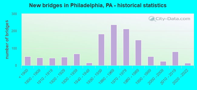
- New bridges - historical statistics
- 53Before 1900
- 451900-1909
- 431910-1919
- 481920-1929
- 681930-1939
- 151940-1949
- 1831950-1959
- 2381960-1969
- 2131970-1979
- 1491980-1989
- 531990-1999
- 252000-2009
- 802010-2019
- 142020-2022
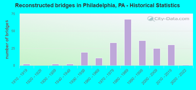
- Reconstructed bridges - Historical Statistics
- 21910-1919
- 01920-1929
- 21930-1939
- 21940-1949
- 191950-1959
- 111960-1969
- 331970-1979
- 671980-1989
- 361990-1999
- 252000-2009
- 302010-2019
- 12020-2022
- Bridge Condition - Deck
- 1.0%Excellent
- 11.5%Very good
- 24.4%Good
- 34.4%Satisfactory
- 21.9%Fair
- 6.0%Poor
- 0.9%Serious
- Bridge Condition - Superstructure
- 1.5%Excellent
- 11.3%Very good
- 18.7%Good
- 32.9%Satisfactory
- 26.6%Fair
- 7.5%Poor
- 1.2%Serious
- 0.3%Imminent failure
- 0.2%Failed
- Bridge Condition - Substructure
- 6.5%Excellent
- 18.9%Very good
- 34.6%Good
- 30.3%Satisfactory
- 7.9%Fair
- 1.1%Poor
- 0.8%Serious
- 0.2%Critical
- Bridge Condition - Channel
- 1.5%Excellent
- 4.0%Very good
- 16.1%Good
- 23.6%Satisfactory
- 34.2%Fair
- 19.6%Poor
- 1.0%Serious
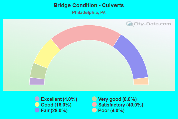
- Bridge Condition - Culverts
- 3.3%Excellent
- 6.7%Very good
- 20.0%Good
- 43.3%Satisfactory
- 23.3%Fair
- 3.3%Poor
Find on map >> Show street view
Structure Number: 39068, Location: CHESTNUT HILL 3369J10 (Lat: 40.066189, Lng: -75.196258), Route carried "on" structure: State highway , Year Built: 1885, Year Reconstructed: 2008, Status: Open, Structure Length: 0.76m (2.49ft), Average Daily Traffic: 9,516 (year 2022), Truck Traffic: 7%, Average Future Daily Traffic: 12,495 (year 2032), Design Load: HL 93, Features Intersected: CRESHEIM CREEK, Facility Carried by Structure: GERMANTOWN AVENUE
Minimum Vertical Clearance: 30+ m (98+ ft), Kilometerpoint: 7.527, Lanes on structure: 2, Base Highway Network: Yes, Owner: State Highway Agency, Maintenance Responsibility: Town or Township Highway Agency, Approaching Roadway Width: 11.0m (36.1ft), Skew: 2 degrees, Material/Design: Masonry, Design/Construction: Arch - Deck, Number Of Spans In Main Unit: 1, Length of Maximum Span: 7.6m (24.9ft), Curb or Sidewalk Widths: Left: 3.0m (9.8ft), Right: 3.0m (9.8ft), Curb-To-Curb Width: 11.0m (36.1ft), Out-to-Out Width: 18.2m (59.7ft)
Condition: Superstructure: Satisfactory, Substructure: Satisfactory, Channel: Satisfactory, Operating Rating: 68.9 metric tons, Method Used To Determine Operating Rating: Field evaluation and documented engineering judgment, Inventory Rating: 50.8 metric tons, Method Used To Determine Inventory Rating: Field evaluation and documented engineering judgment, Structural Evaluation: Equal to present minimum criteria, Deck Geometry: Meets minimum limits, Waterway Adequacy: Somewhat better than minimum adequacy, Approach Roadway Alignment: Equal to present desirable criteria, Length Of Structure Improvement: 1.50m (4.92ft), Designated Inspection Frequency: Every 24 months, Inspection Date: March 2020, Bridge Improvement Cost: $73,000, Roadway Improvement Cost: $214,000, Total Project Cost: $981,000, Deck Structure Type: Concrete Cast-file-Place, Wearing Surface/Protective System: Wearing Surface: Monolithic Concrete, Deck Protection: Epoxy Coated Reinforcing
Find on map >> Show street view
Structure Number: 39071, Location: AT ROOSEVELT BLVD 3480D08 (Lat: 40.017869, Lng: -75.166350), Route carried "on" structure: State highway , Year Built: 1959, Year Reconstructed: 1987, Status: Open, Structure Length: 4.63m (15.19ft), Average Daily Traffic: 7,474 (year 2022), Truck Traffic: 5%, Average Future Daily Traffic: 12,512 (year 2032), Design Load: HS 25 or greater, Features Intersected: ROOSEVELT BLVD.RAMP M NB, Facility Carried by Structure: ROBERTS AVE.W.B.
Minimum Vertical Clearance: 30+ m (98+ ft), Kilometerpoint: 1.093, Lanes on structure: 1, Lanes under structure: 1, Owner: State Highway Agency, Approaching Roadway Width: 7.3m (24.0ft), Skew: 4 degrees, Material/Design: Steel continuous, Design/Construction: Stringer/Multi-beam, Number Of Spans In Main Unit: 3, Length of Maximum Span: 16.5m (54.1ft), Curb or Sidewalk Widths: Left: 0.2m (0.7ft), Right: 0.2m (0.7ft), Curb-To-Curb Width: 8.5m (27.9ft), Out-to-Out Width: 9.3m (30.5ft)
Condition: Deck: Good, Superstructure: Satisfactory, Substructure: Fair, Operating Rating: 64.4 metric tons, Method Used To Determine Operating Rating: Load Factor (LF), Inventory Rating: 38.1 metric tons, Method Used To Determine Inventory Rating: Load Factor (LF), Structural Evaluation: Somewhat better than minimum adequacy, Deck Geometry: High priority of replacement, Underclear: High priority of corrective action, Approach Roadway Alignment: Equal to present minimum criteria, Length Of Structure Improvement: 5.50m (18.04ft), Designated Inspection Frequency: Every 24 months, Inspection Date: March 2020, Deck Structure Type: Concrete Cast-file-Place, Wearing Surface/Protective System: Wearing Surface: Latex Concrete, Deck Protection: Epoxy Coated Reinforcing
Find on map >> Show street view
Structure Number: 39073, Location: .5MI. S.WAYNE AVE.3480B06 (Lat: 40.026222, Lng: -75.177722), Route carried "on" structure: State highway , Year Built: 1901, Status: Closed, Structure Length: 1.74m (5.71ft), Average Daily Traffic: 5,035 (year 2022), Truck Traffic: 5%, Average Future Daily Traffic: 6,984 (year 2032), Design Load: H 15, Features Intersected: SEPTA;CHESTNUT HI. W.BR., Facility Carried by Structure: W. COULTER STREET
Minimum Vertical Clearance: 30+ m (98+ ft), Kilometerpoint: 2.129, Lanes on structure: 2, Owner: State Highway Agency, Approaching Roadway Width: 9.1m (29.9ft), Skew: 5 degrees, Material/Design: Steel, Design/Construction: Girder and Floorbeam System, Number Of Spans In Main Unit: 1, Length of Maximum Span: 16.2m (53.1ft), Curb or Sidewalk Widths: Left: 2.3m (7.5ft), Right: 2.3m (7.5ft), Curb-To-Curb Width: 9.1m (29.9ft), Out-to-Out Width: 14.9m (48.9ft)
Condition: Deck: Serious, Superstructure: Serious, Substructure: Fair, Operating Rating: 3.6 metric tons, Method Used To Determine Operating Rating: Load Factor (LF), Inventory Rating: 1.8 metric tons, Method Used To Determine Inventory Rating: Load Factor (LF), Deck Geometry: High priority of corrective action, Approach Roadway Alignment: Equal to present desirable criteria, Bridge Posting: Required (Relationship of Operating Rating to Maximum Legal Load: > 39.9% below), Length Of Structure Improvement: 2.40m (7.87ft), Designated Inspection Frequency: Every 24 months, Critical Feature Inspection Frequency: Every 6 months, Other Special Inspection Frequency: Every 6 months, Inspection Date: August 2020, Critical Feature Inspection Date: August 2021, Other Special Inspection Date: August 2021, Bridge Improvement Cost: $76,000, Roadway Improvement Cost: $225,000, Total Project Cost: $1,031,000, Deck Structure Type: Steel plate, Wearing Surface/Protective System: Wearing Surface: Bituminous
Find on map >> Show street view
Structure Number: 39074, Location: CHESTNUT HILL 3479 H05 (Lat: 40.031694, Lng: -75.200336), Route carried "on" structure: State highway , Year Built: 1907, Status: Open, Structure Length: 17.22m (56.50ft), Average Daily Traffic: 16,229 (year 2022), Truck Traffic: 5%, Average Future Daily Traffic: 20,861 (year 2032), Design Load: H 20, Features Intersected: WISSAHICKON CREEK, Facility Carried by Structure: WALNUT LANE
Minimum Vertical Clearance: 30+ m (98+ ft), Kilometerpoint: 0.377, Lanes on structure: 2, Base Highway Network: Yes, Owner: State Highway Agency, Maintenance Responsibility: Town or Township Highway Agency, Approaching Roadway Width: 12.8m (42.0ft), Skew: 20 degrees, Material/Design: Concrete, Design/Construction: Arch - Deck, Number Of Spans In Main Unit: 1, Number Of Approach Spans: 5, Length of Maximum Span: 70.7m (232.0ft), Curb or Sidewalk Widths: Left: 1.9m (6.2ft), Right: 1.9m (6.2ft), Curb-To-Curb Width: 12.2m (40.0ft), Out-to-Out Width: 18.3m (60.0ft)
Condition: Deck: Good, Superstructure: Satisfactory, Substructure: Fair, Channel: Very good, Operating Rating: 34.5 metric tons, Method Used To Determine Operating Rating: Load Factor (LF), Inventory Rating: 20.9 metric tons, Method Used To Determine Inventory Rating: Load Factor (LF), Structural Evaluation: Somewhat better than minimum adequacy, Deck Geometry: Somewhat better than minimum adequacy, Waterway Adequacy: Superior to present desirable criteria, Approach Roadway Alignment: Equal to present minimum criteria, Length Of Structure Improvement: 18.50m (60.70ft), Designated Inspection Frequency: Every 24 months, Inspection Date: August 2020, Bridge Improvement Cost: $34,000, Roadway Improvement Cost: $101,000, Total Project Cost: $464,000, Wearing Surface/Protective System: Wearing Surface: Bituminous
Find on map >> Show street view
Structure Number: 39075, Location: FAIRMOUNT PARK E. 3479K05 (Lat: 40.032939, Lng: -75.187853), Route carried "on" structure: State highway , Year Built: 1949, Year Reconstructed: 1990, Status: Open, Structure Length: 9.42m (30.91ft), Average Daily Traffic: 7,959 (year 2020), Truck Traffic: 6%, Average Future Daily Traffic: 8,603 (year 2032), Design Load: HS 25 or greater, Features Intersected: LINCOLN DR,MONOSHONE CK., Facility Carried by Structure: WALNUT LANE
Minimum Vertical Clearance: 30+ m (98+ ft), Kilometerpoint: 0.805, Lanes on structure: 2, Lanes under structure: 4, Base Highway Network: Yes, Owner: State Highway Agency, Approaching Roadway Width: 13.4m (44.0ft), Material/Design: Prestressed concrete continuous, Design/Construction: Stringer/Multi-beam, Number Of Spans In Main Unit: 3, Length of Maximum Span: 48.2m (158.1ft), Curb or Sidewalk Widths: Left: 2.3m (7.5ft), Right: 2.3m (7.5ft), Curb-To-Curb Width: 13.4m (44.0ft), Out-to-Out Width: 19.4m (63.6ft)
Condition: Deck: Satisfactory, Superstructure: Good, Substructure: Good, Channel: Good, Operating Rating: 97.1 metric tons, Method Used To Determine Operating Rating: Load Factor (LF), Inventory Rating: 29.9 metric tons, Method Used To Determine Inventory Rating: Load Factor (LF), Structural Evaluation: Better than present minimum criteria, Deck Geometry: Equal to present minimum criteria, Underclear: Superior to present desirable criteria, Waterway Adequacy: Superior to present desirable criteria, Approach Roadway Alignment: Equal to present desirable criteria, Length Of Structure Improvement: 10.50m (34.45ft), Designated Inspection Frequency: Every 24 months, Inspection Date: Febuary 2020, Deck Structure Type: Concrete Cast-file-Place, Wearing Surface/Protective System: Wearing Surface: Monolithic Concrete, Deck Protection: Epoxy Coated Reinforcing
Find on map >> Show street view
Structure Number: 39076, Location: SOUTH WAYNE AVE. 3480A05 (Lat: 40.033581, Lng: -75.185650), Route carried "on" structure: State highway , Year Built: 1900, Year Reconstructed: 1992, Status: Posted for load, Structure Length: 1.10m (3.61ft), Average Daily Traffic: 7,959 (year 2020), Truck Traffic: 6%, Average Future Daily Traffic: 8,603 (year 2032), Design Load: HS 25 or greater, Features Intersected: SEPTA;CHESTNUTHILL W.BR., Facility Carried by Structure: WALNUT LANE
Minimum Vertical Clearance: 30+ m (98+ ft), Kilometerpoint: 0.805, Lanes on structure: 2, Base Highway Network: Yes, Owner: State Highway Agency, Approaching Roadway Width: 13.4m (44.0ft), Skew: 1 degrees, Material/Design: Prestressed concrete, Design/Construction: Box Beam or Girders - Multiple, Number Of Spans In Main Unit: 1, Length of Maximum Span: 9.4m (30.8ft), Curb or Sidewalk Widths: Left: 2.7m (8.9ft), Right: 2.7m (8.9ft), Curb-To-Curb Width: 13.4m (44.0ft), Out-to-Out Width: 19.6m (64.3ft)
Condition: Deck: Fair, Superstructure: Poor, Substructure: Satisfactory, Operating Rating: 40.8 metric tons, Method Used To Determine Operating Rating: Load Factor (LF), Inventory Rating: 20.9 metric tons, Method Used To Determine Inventory Rating: Load Factor (LF), Structural Evaluation: Meets minimum limits, Deck Geometry: Equal to present minimum criteria, Underclear: High priority of corrective action, Approach Roadway Alignment: Equal to present minimum criteria, Bridge Posting: Required (Relationship of Operating Rating to Maximum Legal Load: 10.0 - 19.9% below), Length Of Structure Improvement: 1.60m (5.25ft), Designated Inspection Frequency: Every 24 months, Other Special Inspection Frequency: Every 12 months, Inspection Date: August 2020, Other Special Inspection Date: August 2021, Deck Structure Type: Concrete Cast-file-Place, Wearing Surface/Protective System: Wearing Surface: Monolithic Concrete, Deck Protection: Epoxy Coated Reinforcing
Find on map >> Show street view
Structure Number: 39077, Location: WAYNE;WASHINGTON 3479K05 (Lat: 40.036700, Lng: -75.188297), Route carried "on" structure: State highway , Year Built: 1894, Year Reconstructed: 1983, Status: Open, Structure Length: 10.85m (35.60ft), Average Daily Traffic: 5,663 (year 2022), Truck Traffic: 4%, Average Future Daily Traffic: 7,414 (year 2032), Design Load: HS 20, Features Intersected: SEPTA (CHESTNUT HILL), Facility Carried by Structure: WAYNE AVENUE
Minimum Vertical Clearance: 30+ m (98+ ft), Kilometerpoint: 1.247, Lanes on structure: 2, Owner: Railroad, Maintenance Responsibility: State Highway Agency, Approaching Roadway Width: 12.8m (42.0ft), Skew: 20 degrees, Material/Design: Steel, Design/Construction: Stringer/Multi-beam, Number Of Spans In Main Unit: 3, Number Of Approach Spans: 2, Length of Maximum Span: 27.1m (88.9ft), Curb or Sidewalk Widths: Left: 1.5m (4.9ft), Right: 1.5m (4.9ft), Curb-To-Curb Width: 14.0m (45.9ft), Out-to-Out Width: 18.9m (62.0ft)
Condition: Deck: Satisfactory, Superstructure: Fair, Substructure: Fair, Operating Rating: 82.6 metric tons, Method Used To Determine Operating Rating: Load Factor (LF), Inventory Rating: 49.0 metric tons, Method Used To Determine Inventory Rating: Load Factor (LF), Structural Evaluation: Somewhat better than minimum adequacy, Deck Geometry: Superior to present desirable criteria, Underclear: High priority of corrective action, Approach Roadway Alignment: Better than present minimum criteria, Length Of Structure Improvement: 11.80m (38.71ft), Designated Inspection Frequency: Every 24 months, Critical Feature Inspection Frequency: Every 24 months, Inspection Date: August 2020, Critical Feature Inspection Date: August 2020, Bridge Improvement Cost: $79,000, Roadway Improvement Cost: $231,000, Total Project Cost: $1,061,000, Deck Structure Type: Concrete Cast-file-Place, Wearing Surface/Protective System: Wearing Surface: Monolithic Concrete, Deck Protection: Epoxy Coated Reinforcing
Find on map >> Show street view
Structure Number: 3908, Location: .3MI.NE.GERMANTOWN3369K10 (Lat: 40.063608, Lng: -75.187394), Route carried "on" structure: State highway , Year Built: 1939, Year Reconstructed: 1976, Status: Open, Structure Length: 1.62m (5.31ft), Average Daily Traffic: 5,901 (year 2021), Truck Traffic: 4%, Average Future Daily Traffic: 8,339 (year 2032), Design Load: H 20, Features Intersected: SEPTA;CHESTNUT HILL BR., Facility Carried by Structure: MOUNT AIRY AVENUE
Minimum Vertical Clearance: 30+ m (98+ ft), Kilometerpoint: 0.000, Lanes on structure: 2, Base Highway Network: Yes, Owner: State Highway Agency, Approaching Roadway Width: 9.1m (29.9ft), Skew: 1 degrees, Material/Design: Steel, Design/Construction: Stringer/Multi-beam, Number Of Spans In Main Unit: 1, Length of Maximum Span: 15.2m (49.9ft), Curb or Sidewalk Widths: Left: 1.9m (6.2ft), Right: 1.9m (6.2ft), Curb-To-Curb Width: 9.1m (29.9ft), Out-to-Out Width: 13.9m (45.6ft)
Condition: Deck: Satisfactory, Superstructure: Fair, Substructure: Fair, Operating Rating: 74.4 metric tons, Method Used To Determine Operating Rating: Load Factor (LF), Inventory Rating: 44.5 metric tons, Method Used To Determine Inventory Rating: Load Factor (LF), Structural Evaluation: Somewhat better than minimum adequacy, Deck Geometry: High priority of corrective action, Underclear: High priority of corrective action, Approach Roadway Alignment: Equal to present desirable criteria, Length Of Structure Improvement: 1.60m (5.25ft), Designated Inspection Frequency: Every 24 months, Inspection Date: August 2020, Bridge Improvement Cost: $51,000, Roadway Improvement Cost: $474,000, Total Project Cost: $690,000, Deck Structure Type: Concrete Cast-file-Place, Wearing Surface/Protective System: Wearing Surface: Monolithic Concrete, Deck Protection: Galvanized Reinforcing
Find on map >> Show street view
Structure Number: 39081, Location: .3MI.NE.GERMANTOWN3370A10 (Lat: 40.063928, Lng: -75.187053), Route carried "on" structure: State highway , Year Built: 1939, Year Reconstructed: 1976, Status: Open, Structure Length: 1.68m (5.51ft), Average Daily Traffic: 5,901 (year 2021), Truck Traffic: 4%, Average Future Daily Traffic: 8,339 (year 2032), Design Load: H 20, Features Intersected: SPRAGUE STREET(ONE WAY), Facility Carried by Structure: MOUNT AIRY AVENUE
Minimum Vertical Clearance: 30+ m (98+ ft), Kilometerpoint: 0.000, Lanes on structure: 2, Lanes under structure: 1, Base Highway Network: Yes, Owner: State Highway Agency, Approaching Roadway Width: 9.1m (29.9ft), Material/Design: Concrete continuous, Design/Construction: Stringer/Multi-beam, Number Of Spans In Main Unit: 1, Length of Maximum Span: 15.8m (51.8ft), Curb or Sidewalk Widths: Left: 1.9m (6.2ft), Right: 1.9m (6.2ft), Curb-To-Curb Width: 9.1m (29.9ft), Out-to-Out Width: 13.9m (45.6ft)
Condition: Deck: Satisfactory, Superstructure: Satisfactory, Substructure: Fair, Operating Rating: 66.2 metric tons, Method Used To Determine Operating Rating: Load Factor (LF), Inventory Rating: 39.9 metric tons, Method Used To Determine Inventory Rating: Load Factor (LF), Structural Evaluation: Somewhat better than minimum adequacy, Deck Geometry: High priority of corrective action, Underclear: High priority of corrective action, Approach Roadway Alignment: Better than present minimum criteria, Length Of Structure Improvement: 2.40m (7.87ft), Designated Inspection Frequency: Every 24 months, Inspection Date: August 2020, Bridge Improvement Cost: $8,000, Roadway Improvement Cost: $23,000, Total Project Cost: $106,000, Deck Structure Type: Concrete Cast-file-Place, Wearing Surface/Protective System: Wearing Surface: Monolithic Concrete, Deck Protection: Galvanized Reinforcing
Find on map >> Show street view
Structure Number: 39092, Location: N.PLATT BRIDGE 3699D08 (Lat: 39.891083, Lng: -75.228969), Route carried "on" structure: State highway 291, Year Built: 1985, Status: Open, Structure Length: 5.12m (16.80ft), Average Daily Traffic: 34,695 (year 2022), Truck Traffic: 3%, Average Future Daily Traffic: 33,386 (year 2032), Design Load: HS 20, Features Intersected: RAMP V OFF TO PLATT BRDG, Facility Carried by Structure: RELOCATED PENROSE
Minimum Vertical Clearance: 30+ m (98+ ft), Kilometerpoint: 3.582, Lanes on structure: 1, Lanes under structure: 1, Base Highway Network: Yes, Owner: State Highway Agency, Approaching Roadway Width: 9.4m (30.8ft), Skew: 2 degrees, Material/Design: Prestressed concrete, Design/Construction: Stringer/Multi-beam, Number Of Spans In Main Unit: 1, Number Of Approach Spans: 2, Length of Maximum Span: 30.5m (100.1ft), Curb or Sidewalk Widths: Left: 0.2m (0.7ft), Right: 0.2m (0.7ft), Curb-To-Curb Width: 9.1m (29.9ft), Out-to-Out Width: 10.5m (34.4ft)
Condition: Deck: Good, Superstructure: Satisfactory, Substructure: Satisfactory, Operating Rating: 64.4 metric tons, Method Used To Determine Operating Rating: Load Factor (LF), Inventory Rating: 29.0 metric tons, Method Used To Determine Inventory Rating: Load Factor (LF), Structural Evaluation: Equal to present minimum criteria, Deck Geometry: High priority of corrective action, Underclear: Equal to present minimum criteria, Approach Roadway Alignment: Better than present minimum criteria, Length Of Structure Improvement: 6.10m (20.01ft), Designated Inspection Frequency: Every 24 months, Inspection Date: April 2020, Deck Structure Type: Concrete Cast-file-Place, Wearing Surface/Protective System: Wearing Surface: Monolithic Concrete, Deck Protection: Epoxy Coated Reinforcing
Find on map >> Show street view
Structure Number: 39093, Location: N of Venango Street 29A02 (Lat: 40.005200, Lng: -75.131900), Route carried "on" structure: City street , Year Built: 1926, Status: Open, Structure Length: 2.65m (8.69ft), Average Daily Traffic: 14,600 (year 1980), Average Future Daily Traffic: 14,600 (year 1982), Features Intersected: AMTRAK (NE CORRIDOR), Facility Carried by Structure: 2nd Street
Minimum Vertical Clearance: 30+ m (98+ ft), Kilometerpoint: 0.000, Lanes on structure: 2, Owner: City or Municipal Highway Agency, Approaching Roadway Width: 11.6m (38.1ft), Skew: 1 degrees, Material/Design: Steel, Design/Construction: Stringer/Multi-beam, Number Of Spans In Main Unit: 1, Length of Maximum Span: 25.9m (85.0ft), Curb or Sidewalk Widths: Left: 3.0m (9.8ft), Right: 3.0m (9.8ft), Curb-To-Curb Width: 11.6m (38.1ft), Out-to-Out Width: 18.3m (60.0ft)
Condition: Deck: Poor, Superstructure: Poor, Substructure: Serious, Operating Rating: 85.3 metric tons, Method Used To Determine Operating Rating: Allowable Stress (AS), Inventory Rating: 34.5 metric tons, Method Used To Determine Inventory Rating: Allowable Stress (AS), Structural Evaluation: High priority of corrective action, Deck Geometry: Somewhat better than minimum adequacy, Underclear: High priority of corrective action, Approach Roadway Alignment: Somewhat better than minimum adequacy, Length Of Structure Improvement: 2.70m (8.86ft), Designated Inspection Frequency: Every 24 months, Other Special Inspection Frequency: Every 12 months, Inspection Date: July 2021, Other Special Inspection Date: July 2021, Bridge Improvement Cost: $78,000, Roadway Improvement Cost: $229,000, Total Project Cost: $1,051,000, Wearing Surface/Protective System: Wearing Surface: Bituminous
Find on map >> Show street view
Structure Number: 39094, Location: S.CLEARFIELD ST. 29A04 (Lat: 39.996833, Lng: -75.133703), Route carried "on" structure: City street , Year Built: 1964, Status: Open, Structure Length: 6.61m (21.69ft), Average Daily Traffic: 11,400 (year 1977), Average Future Daily Traffic: 15,960 (year 1997), Design Load: HS 20, Features Intersected: CONRAIL (RICHMOND BRANCH, Facility Carried by Structure: 2nd Street
Minimum Vertical Clearance: 30+ m (98+ ft), Kilometerpoint: 0.000, Lanes on structure: 2, Owner: City or Municipal Highway Agency, Approaching Roadway Width: 10.4m (34.1ft), Skew: 2 degrees, Material/Design: Steel continuous, Design/Construction: Girder and Floorbeam System, Number Of Spans In Main Unit: 3, Length of Maximum Span: 24.7m (81.0ft), Curb or Sidewalk Widths: Left: 3.1m (10.2ft), Right: 3.1m (10.2ft), Curb-To-Curb Width: 9.3m (30.5ft), Out-to-Out Width: 9.7m (31.8ft)
Condition: Deck: Satisfactory, Superstructure: Satisfactory, Substructure: Good, Operating Rating: 49.9 metric tons, Method Used To Determine Operating Rating: Allowable Stress (AS), Inventory Rating: 26.3 metric tons, Method Used To Determine Inventory Rating: Allowable Stress (AS), Structural Evaluation: Equal to present minimum criteria, Deck Geometry: Meets minimum limits, Underclear: High priority of corrective action, Approach Roadway Alignment: Equal to present minimum criteria, Length Of Structure Improvement: 7.60m (24.93ft), Designated Inspection Frequency: Every 24 months, Critical Feature Inspection Frequency: Every 24 months, Inspection Date: March 2021, Critical Feature Inspection Date: March 2021, Bridge Improvement Cost: $18,000, Roadway Improvement Cost: $52,000, Total Project Cost: $238,000, Deck Structure Type: Concrete Cast-file-Place, Wearing Surface/Protective System: Wearing Surface: Bituminous
Find on map >> Show street view
Structure Number: 39095, Location: at Luzerne Steet 29A01 (Lat: 40.011356, Lng: -75.130564), Route carried "on" structure: City street , Year Built: 1926, Status: Open, Structure Length: 2.32m (7.61ft), Average Daily Traffic: 8,800 (year 1977), Average Future Daily Traffic: 12,320 (year 1997), Features Intersected: Luzerne Street, Facility Carried by Structure: 2nd Street
Minimum Vertical Clearance: 30+ m (98+ ft), Kilometerpoint: 0.000, Lanes on structure: 2, Lanes under structure: 2, Base Highway Network: Yes, Owner: City or Municipal Highway Agency, Approaching Roadway Width: 6.7m (22.0ft), Material/Design: Steel, Design/Construction: Stringer/Multi-beam, Number Of Spans In Main Unit: 3, Length of Maximum Span: 13.7m (44.9ft), Curb or Sidewalk Widths: Left: 2.2m (7.2ft), Right: 2.2m (7.2ft), Curb-To-Curb Width: 6.7m (22.0ft), Out-to-Out Width: 15.5m (50.9ft)
Condition: Deck: Fair, Superstructure: Fair, Substructure: Fair, Operating Rating: 88.9 metric tons, Method Used To Determine Operating Rating: Allowable Stress (AS), Inventory Rating: 57.2 metric tons, Method Used To Determine Inventory Rating: Allowable Stress (AS), Structural Evaluation: Somewhat better than minimum adequacy, Deck Geometry: High priority of replacement, Underclear: High priority of corrective action, Approach Roadway Alignment: Equal to present desirable criteria, Length Of Structure Improvement: 3.00m (9.84ft), Designated Inspection Frequency: Every 24 months, Inspection Date: June 2021, Bridge Improvement Cost: $62,000, Roadway Improvement Cost: $182,000, Total Project Cost: $835,000, Deck Structure Type: Other, Wearing Surface/Protective System: Wearing Surface: Integral Concrete
Find on map >> Show street view
Structure Number: 39097, Location: Cambria & "A" Sts - 29A05 (Lat: 39.993583, Lng: -75.128536), Route carried "on" structure: City street , Year Built: 1916, Status: Posted for load, Structure Length: 5.61m (18.41ft), Average Daily Traffic: 3,200 (year 1980), Average Future Daily Traffic: 4,480 (year 2000), Features Intersected: CONRAIL, Facility Carried by Structure: Cambria & "A" Sts
Minimum Vertical Clearance: 30+ m (98+ ft), Kilometerpoint: 0.000, Lanes on structure: 2, Owner: City or Municipal Highway Agency, Approaching Roadway Width: 7.9m (25.9ft), Material/Design: Steel, Design/Construction: Girder and Floorbeam System, Number Of Spans In Main Unit: 1, Number Of Approach Spans: 2, Length of Maximum Span: 24.7m (81.0ft), Curb or Sidewalk Widths: Left: 2.1m (6.9ft), Right: 2.1m (6.9ft), Curb-To-Curb Width: 11.0m (36.1ft), Out-to-Out Width: 15.3m (50.2ft)
Condition: Deck: Poor, Superstructure: Fair, Substructure: Fair, Operating Rating: 51.7 metric tons, Method Used To Determine Operating Rating: Allowable Stress (AS), Inventory Rating: 22.7 metric tons, Method Used To Determine Inventory Rating: Allowable Stress (AS), Structural Evaluation: Somewhat better than minimum adequacy, Deck Geometry: Somewhat better than minimum adequacy, Underclear: High priority of corrective action, Approach Roadway Alignment: Meets minimum limits, Length Of Structure Improvement: 6.50m (21.33ft), Designated Inspection Frequency: Every 24 months, Critical Feature Inspection Frequency: Every 12 months, Other Special Inspection Frequency: Every 12 months, Inspection Date: March 2021, Critical Feature Inspection Date: March 2021, Other Special Inspection Date: March 2021, Bridge Improvement Cost: $23,000, Roadway Improvement Cost: $66,000, Total Project Cost: $305,000, Wearing Surface/Protective System: Wearing Surface: Bituminous
Find on map >> Show street view
Structure Number: 39098, Location: W of 5th Street 18A13 (Lat: 40.018314, Lng: -75.135867), Route carried "on" structure: City street , Year Built: 1930, Status: Open, Structure Length: 2.10m (6.89ft), Average Daily Traffic: 1,500 (year 1980), Average Future Daily Traffic: 1,500 (year 1980), Features Intersected: Abandoned CONRAIL, Facility Carried by Structure: Cayuga Street
Minimum Vertical Clearance: 30+ m (98+ ft), Kilometerpoint: 0.000, Lanes on structure: 2, Owner: City or Municipal Highway Agency, Approaching Roadway Width: 11.0m (36.1ft), Skew: 2 degrees, Material/Design: Steel, Design/Construction: Stringer/Multi-beam, Number Of Spans In Main Unit: 1, Length of Maximum Span: 20.1m (65.9ft), Curb or Sidewalk Widths: Left: 3.0m (9.8ft), Right: 3.0m (9.8ft), Curb-To-Curb Width: 11.0m (36.1ft), Out-to-Out Width: 11.4m (37.4ft)
Condition: Deck: Poor, Superstructure: Poor, Substructure: Poor, Operating Rating: 82.6 metric tons, Method Used To Determine Operating Rating: Allowable Stress (AS), Inventory Rating: 36.3 metric tons, Method Used To Determine Inventory Rating: Allowable Stress (AS), Structural Evaluation: Meets minimum limits, Deck Geometry: Equal to present minimum criteria, Approach Roadway Alignment: Meets minimum limits, Length Of Structure Improvement: 2.10m (6.89ft), Designated Inspection Frequency: Every 24 months, Inspection Date: June 2021, Bridge Improvement Cost: $10,000, Roadway Improvement Cost: $28,000, Total Project Cost: $129,000, Wearing Surface/Protective System: Wearing Surface: Bituminous
Find on map >> Show street view
Structure Number: 39099, Location: East of Henry Ave 3480-B8 (Lat: 40.014492, Lng: -75.178256), Route carried "on" structure: Alternate City street , Year Built: 1960, Status: Open, Structure Length: 3.17m (10.40ft), Average Daily Traffic: 10,000 (year 1981), Truck Traffic: 3%, Average Future Daily Traffic: 14,000 (year 2001), Design Load: HS 20, Features Intersected: Roosevelt Blvd Ext (US1), Facility Carried by Structure: Fox Street
Minimum Vertical Clearance: 30+ m (98+ ft), Kilometerpoint: 0.000, Lanes on structure: 4, Lanes under structure: 6, Owner: City or Municipal Highway Agency, Approaching Roadway Width: 13.4m (44.0ft), Material/Design: Steel, Design/Construction: Stringer/Multi-beam, Number Of Spans In Main Unit: 1, Length of Maximum Span: 30.2m (99.1ft), Curb or Sidewalk Widths: Left: 3.0m (9.8ft), Right: 3.0m (9.8ft), Curb-To-Curb Width: 13.4m (44.0ft), Out-to-Out Width: 20.3m (66.6ft)
Condition: Deck: Satisfactory, Superstructure: Poor, Substructure: Poor, Operating Rating: 82.6 metric tons, Method Used To Determine Operating Rating: Load Factor (LF), Inventory Rating: 49.0 metric tons, Method Used To Determine Inventory Rating: Load Factor (LF), Structural Evaluation: Meets minimum limits, Deck Geometry: High priority of replacement, Underclear: High priority of corrective action, Approach Roadway Alignment: Better than present minimum criteria, Length Of Structure Improvement: 4.00m (13.12ft), Designated Inspection Frequency: Every 24 months, Other Special Inspection Frequency: Every 6 months, Inspection Date: March 2021, Other Special Inspection Date: September 2021, Bridge Improvement Cost: $70,000, Roadway Improvement Cost: $207,000, Total Project Cost: $947,000, Deck Structure Type: Concrete Cast-file-Place, Wearing Surface/Protective System: Wearing Surface: Bituminous
Find on map >> Show street view
Structure Number: 391, Location: N of Cambria Street 29A04 (Lat: 39.994800, Lng: -75.130067), Route carried "on" structure: City street , Year Built: 1985, Status: Open, Structure Length: 3.11m (10.20ft), Average Daily Traffic: 8,000 (year 2012), Average Future Daily Traffic: 10,250 (year 2032), Design Load: HS 20, Features Intersected: CONRAIL (Richmond Br), Facility Carried by Structure: Front Street
Minimum Vertical Clearance: 30+ m (98+ ft), Kilometerpoint: 0.000, Lanes on structure: 2, Owner: City or Municipal Highway Agency, Approaching Roadway Width: 11.6m (38.1ft), Skew: 3 degrees, Material/Design: Steel, Design/Construction: Girder and Floorbeam System, Number Of Spans In Main Unit: 1, Length of Maximum Span: 29.6m (97.1ft), Curb or Sidewalk Widths: Left: 1.7m (5.6ft), Right: 1.7m (5.6ft), Curb-To-Curb Width: 11.6m (38.1ft), Out-to-Out Width: 16.0m (52.5ft)
Condition: Deck: Good, Superstructure: Satisfactory, Substructure: Satisfactory, Operating Rating: 68.0 metric tons, Method Used To Determine Operating Rating: Allowable Stress (AS), Inventory Rating: 40.8 metric tons, Method Used To Determine Inventory Rating: Allowable Stress (AS), Structural Evaluation: Equal to present minimum criteria, Deck Geometry: Better than present minimum criteria, Underclear: High priority of replacement, Approach Roadway Alignment: Equal to present minimum criteria, Length Of Structure Improvement: 3.70m (12.14ft), Designated Inspection Frequency: Every 24 months, Critical Feature Inspection Frequency: Every 24 months, Inspection Date: March 2021, Critical Feature Inspection Date: March 2021, Bridge Improvement Cost: $184,000, Roadway Improvement Cost: $542,000, Total Project Cost: $2,485,000, Deck Structure Type: Concrete Cast-file-Place, Wearing Surface/Protective System: Wearing Surface: Monolithic Concrete, Deck Protection: Epoxy Coated Reinforcing
Find on map >> Show street view
Structure Number: 39101, Location: N of Venango Street 29A02 (Lat: 40.005144, Lng: -75.127836), Route carried "on" structure: City street , Year Built: 1908, Year Reconstructed: 1988, Status: Open, Structure Length: 7.44m (24.41ft), Average Daily Traffic: 11,500 (year 1986), Average Future Daily Traffic: 16,100 (year 2006), Design Load: HS 20, Features Intersected: AMTRAK ; CONRAIL, Facility Carried by Structure: Front Street
Minimum Vertical Clearance: 9.14m (29.99ft), Kilometerpoint: 0.000, Lanes on structure: 2, Owner: City or Municipal Highway Agency, Approaching Roadway Width: 15.2m (49.9ft), Material/Design: Steel, Design/Construction: Stringer/Multi-beam, Number Of Spans In Main Unit: 1, Number Of Approach Spans: 2, Length of Maximum Span: 29.9m (98.1ft), Curb or Sidewalk Widths: Left: 3.5m (11.5ft), Right: 3.5m (11.5ft), Curb-To-Curb Width: 15.3m (50.2ft), Out-to-Out Width: 22.9m (75.1ft)
Condition: Deck: Good, Superstructure: Good, Substructure: Good, Operating Rating: 69.9 metric tons, Method Used To Determine Operating Rating: Allowable Stress (AS), Inventory Rating: 29.0 metric tons, Method Used To Determine Inventory Rating: Allowable Stress (AS), Structural Evaluation: Better than present minimum criteria, Deck Geometry: Superior to present desirable criteria, Underclear: High priority of corrective action, Approach Roadway Alignment: Equal to present desirable criteria, Length Of Structure Improvement: 8.40m (27.56ft), Designated Inspection Frequency: Every 24 months, Inspection Date: July 2019, Deck Structure Type: Concrete Cast-file-Place, Wearing Surface/Protective System: Wearing Surface: Latex Concrete, Deck Protection: Epoxy Coated Reinforcing
Find on map >> Show street view
Structure Number: 39103, Location: E of Morris Street 17D11 (Lat: 40.028494, Lng: -75.178772), Route carried "on" structure: City street , Year Built: 1883, Year Reconstructed: 1983, Status: Open, Structure Length: 1.01m (3.31ft), Average Daily Traffic: 6,500 (year 1981), Average Future Daily Traffic: 9,100 (year 2001), Design Load: HS 20, Features Intersected: SEPTA (Chestnut Hill W.), Facility Carried by Structure: School House Lane
Minimum Vertical Clearance: 7.62m (25.00ft), Kilometerpoint: 0.000, Lanes on structure: 2, Owner: City or Municipal Highway Agency, Approaching Roadway Width: 9.1m (29.9ft), Skew: 1 degrees, Material/Design: Prestressed concrete, Design/Construction: Box Beam or Girders - Multiple, Number Of Spans In Main Unit: 1, Length of Maximum Span: 10.1m (33.1ft), Curb or Sidewalk Widths: Left: 2.2m (7.2ft), Right: 2.2m (7.2ft), Curb-To-Curb Width: 9.2m (30.2ft), Out-to-Out Width: 14.3m (46.9ft)
Condition: Deck: Good, Superstructure: Very good, Substructure: Good, Operating Rating: 65.3 metric tons, Method Used To Determine Operating Rating: Load Factor (LF), Inventory Rating: 46.3 metric tons, Method Used To Determine Inventory Rating: Load Factor (LF), Structural Evaluation: Better than present minimum criteria, Deck Geometry: High priority of corrective action, Underclear: High priority of corrective action, Approach Roadway Alignment: Better than present minimum criteria, Length Of Structure Improvement: 1.60m (5.25ft), Designated Inspection Frequency: Every 24 months, Inspection Date: August 2019, Deck Structure Type: Concrete Cast-file-Place, Wearing Surface/Protective System: Wearing Surface: Monolithic Concrete, Deck Protection: Epoxy Coated Reinforcing
Find on map >> Show street view
Structure Number: 39104, Location: AT 2ND STREET (Lat: 40.022017, Lng: -75.128017), Route carried "on" structure: City street , Year Built: 1907, Status: Open, Structure Length: 2.19m (7.19ft), Average Daily Traffic: 6,700 (year 1980), Average Future Daily Traffic: 9,380 (year 2000), Features Intersected: CONRAIL (Abolished), Facility Carried by Structure: Wyoming Avenue
Minimum Vertical Clearance: 4.57m (14.99ft), Kilometerpoint: 0.000, Lanes on structure: 2, Owner: City or Municipal Highway Agency, Approaching Roadway Width: 15.2m (49.9ft), Material/Design: Concrete, Design/Construction: Arch - Deck, Number Of Spans In Main Unit: 1, Length of Maximum Span: 18.3m (60.0ft), Curb or Sidewalk Widths: Left: 3.9m (12.8ft), Right: 3.9m (12.8ft), Curb-To-Curb Width: 15.3m (50.2ft), Out-to-Out Width: 24.3m (79.7ft)
Condition: Superstructure: Satisfactory, Substructure: Satisfactory, Operating Rating: 52.6 metric tons, Method Used To Determine Operating Rating: Allowable Stress (AS), Inventory Rating: 39.0 metric tons, Method Used To Determine Inventory Rating: Allowable Stress (AS), Structural Evaluation: Equal to present minimum criteria, Deck Geometry: Equal to present minimum criteria, Approach Roadway Alignment: Equal to present desirable criteria, Length Of Structure Improvement: 2.90m (9.51ft), Designated Inspection Frequency: Every 24 months, Inspection Date: June 2021, Bridge Improvement Cost: $33,000, Roadway Improvement Cost: $97,000, Total Project Cost: $446,000
Find on map >> Show street view
Structure Number: 39105, Location: W of Wissahickon 17D13 (Lat: 40.015897, Lng: -75.175500), Route carried "on" structure: City street , Year Built: 1929, Status: Open, Structure Length: 2.04m (6.69ft), Average Daily Traffic: 13,600 (year 1980), Average Future Daily Traffic: 13,600 (year 1980), Features Intersected: CONRAIL and SEPTA, Facility Carried by Structure: Abbottsford Avenue
Minimum Vertical Clearance: 30+ m (98+ ft), Kilometerpoint: 0.000, Lanes on structure: 2, Owner: City or Municipal Highway Agency, Approaching Roadway Width: 12.2m (40.0ft), Material/Design: Steel, Design/Construction: Stringer/Multi-beam, Number Of Spans In Main Unit: 1, Length of Maximum Span: 19.2m (63.0ft), Curb or Sidewalk Widths: Left: 3.5m (11.5ft), Right: 3.5m (11.5ft), Curb-To-Curb Width: 14.9m (48.9ft), Out-to-Out Width: 24.4m (80.1ft)
Condition: Deck: Serious, Superstructure: Poor, Substructure: Poor, Operating Rating: 99.8 metric tons, Method Used To Determine Operating Rating: Allowable Stress (AS), Inventory Rating: 26.3 metric tons, Method Used To Determine Inventory Rating: Allowable Stress (AS), Structural Evaluation: Meets minimum limits, Deck Geometry: Superior to present desirable criteria, Underclear: High priority of corrective action, Approach Roadway Alignment: Equal to present desirable criteria, Length Of Structure Improvement: 2.00m (6.56ft), Designated Inspection Frequency: Every 24 months, Inspection Date: September 2019, Bridge Improvement Cost: $80,000, Roadway Improvement Cost: $236,000, Total Project Cost: $1,080,000, Deck Structure Type: Concrete Cast-file-Place, Wearing Surface/Protective System: Wearing Surface: Bituminous
Find on map >> Show street view
Structure Number: 39106, Location: N. of Callowhill 28F11 (Lat: 39.960606, Lng: -75.163564), Route carried "on" structure: City street , Year Built: 1898, Year Reconstructed: 1964, Status: Closed, Structure Length: 7.80m (25.59ft), Average Daily Traffic: 7,800 (year 2012), Average Future Daily Traffic: 9,985 (year 2032), Design Load: HS 20, Features Intersected: Abolished Conrail, Facility Carried by Structure: 15th Street
Minimum Vertical Clearance: 30+ m (98+ ft), Kilometerpoint: 0.000, Lanes on structure: 2, Owner: City or Municipal Highway Agency, Approaching Roadway Width: 7.9m (25.9ft), Material/Design: Steel, Design/Construction: Stringer/Multi-beam, Number Of Spans In Main Unit: 4, Number Of Approach Spans: 2, Length of Maximum Span: 20.4m (66.9ft), Curb or Sidewalk Widths: Left: 3.0m (9.8ft), Right: 3.7m (12.1ft), Curb-To-Curb Width: 8.0m (26.2ft), Out-to-Out Width: 15.3m (50.2ft)
Condition: Deck: Serious, Superstructure: Serious, Substructure: Serious, Operating Rating: 87.1 metric tons, Method Used To Determine Operating Rating: Allowable Stress (AS), Inventory Rating: 50.8 metric tons, Method Used To Determine Inventory Rating: Allowable Stress (AS), Structural Evaluation: High priority of corrective action, Approach Roadway Alignment: High priority of corrective action, Length Of Structure Improvement: 7.80m (25.59ft), Designated Inspection Frequency: Every 24 months, Other Special Inspection Frequency: Every 12 months, Inspection Date: January 2019, Other Special Inspection Date: January 2019, Bridge Improvement Cost: $67,000, Roadway Improvement Cost: $196,000, Total Project Cost: $900,000, Deck Structure Type: Concrete Cast-file-Place, Wearing Surface/Protective System: Wearing Surface: Bituminous
Find on map >> Show street view
Structure Number: 39107, Location: N.CALLOWHILL ST. 28F11 (Lat: 39.960769, Lng: -75.165100), Route carried "on" structure: City street , Year Built: 1968, Status: Open, Structure Length: 1.95m (6.40ft), Average Daily Traffic: 5,300 (year 1980), Average Future Daily Traffic: 7,420 (year 2000), Design Load: HS 20, Features Intersected: Abolished Conrail, Facility Carried by Structure: 16th Street
Minimum Vertical Clearance: 30+ m (98+ ft), Kilometerpoint: 0.000, Lanes on structure: 2, Owner: City or Municipal Highway Agency, Approaching Roadway Width: 7.9m (25.9ft), Material/Design: Steel, Design/Construction: Stringer/Multi-beam, Number Of Spans In Main Unit: 1, Length of Maximum Span: 17.1m (56.1ft), Curb or Sidewalk Widths: Left: 3.3m (10.8ft), Right: 3.3m (10.8ft), Curb-To-Curb Width: 8.0m (26.2ft), Out-to-Out Width: 15.5m (50.9ft)
Condition: Deck: Satisfactory, Superstructure: Good, Substructure: Satisfactory, Operating Rating: 80.7 metric tons, Method Used To Determine Operating Rating: Load Factor (LF), Inventory Rating: 48.1 metric tons, Method Used To Determine Inventory Rating: Load Factor (LF), Structural Evaluation: Equal to present minimum criteria, Deck Geometry: High priority of replacement, Approach Roadway Alignment: Equal to present desirable criteria, Length Of Structure Improvement: 2.70m (8.86ft), Designated Inspection Frequency: Every 24 months, Inspection Date: January 2021, Deck Structure Type: Concrete Cast-file-Place, Wearing Surface/Protective System: Wearing Surface: Bituminous
Find on map >> Show street view
Structure Number: 39108, Location: N of Market Street 28F12 (Lat: 39.954011, Lng: -75.166553), Route carried "on" structure: Business City street , Year Built: 1957, Status: Open, Structure Length: 2.13m (6.99ft), Average Daily Traffic: 17,600 (year 1985), Average Future Daily Traffic: 24,640 (year 2005), Design Load: HS 20, Features Intersected: Penn Ctr Undgrd St Sys, Facility Carried by Structure: 16th Street
Minimum Vertical Clearance: 30+ m (98+ ft), Kilometerpoint: 0.000, Lanes on structure: 4, Owner: City or Municipal Highway Agency, Approaching Roadway Width: 11.3m (37.1ft), Material/Design: Steel, Design/Construction: Girder and Floorbeam System, Number Of Spans In Main Unit: 4, Length of Maximum Span: 5.2m (17.1ft), Curb or Sidewalk Widths: Left: 3.7m (12.1ft), Right: 6.4m (21.0ft), Curb-To-Curb Width: 11.3m (37.1ft), Out-to-Out Width: 21.3m (69.9ft)
Condition: Superstructure: Good, Substructure: Satisfactory, Operating Rating: 66.2 metric tons, Method Used To Determine Operating Rating: Allowable Stress (AS), Inventory Rating: 26.3 metric tons, Method Used To Determine Inventory Rating: Allowable Stress (AS), Structural Evaluation: Equal to present minimum criteria, Deck Geometry: High priority of replacement, Approach Roadway Alignment: Equal to present desirable criteria, Length Of Structure Improvement: 9.20m (30.18ft), Designated Inspection Frequency: Every 24 months, Critical Feature Inspection Frequency: Every 24 months, Inspection Date: Febuary 2021, Critical Feature Inspection Date: Febuary 2021, Bridge Improvement Cost: $46,000, Roadway Improvement Cost: $136,000, Total Project Cost: $624,000, Deck Structure Type: Concrete Cast-file-Place, Wearing Surface/Protective System: Wearing Surface: Bituminous
Find on map >> Show street view
Structure Number: 39109, Location: 28F11 (Lat: 39.960936, Lng: -75.166678), Route carried "on" structure: City street , Year Built: 1898, Year Reconstructed: 1970, Status: Open, Structure Length: 2.50m (8.20ft), Average Daily Traffic: 2,100 (year 1980), Average Future Daily Traffic: 2,100 (year 1980), Design Load: HS 20, Features Intersected: Abolished Conrail, Facility Carried by Structure: 17th Street
Minimum Vertical Clearance: 30+ m (98+ ft), Kilometerpoint: 0.000, Lanes on structure: 1, Owner: City or Municipal Highway Agency, Approaching Roadway Width: 7.9m (25.9ft), Material/Design: Steel, Design/Construction: Stringer/Multi-beam, Number Of Spans In Main Unit: 1, Number Of Approach Spans: 1, Length of Maximum Span: 19.2m (63.0ft), Curb or Sidewalk Widths: Left: 3.1m (10.2ft), Right: 3.1m (10.2ft), Curb-To-Curb Width: 8.0m (26.2ft), Out-to-Out Width: 15.1m (49.5ft)
Condition: Deck: Good, Superstructure: Good, Substructure: Satisfactory, Operating Rating: 79.8 metric tons, Method Used To Determine Operating Rating: Load Factor (LF), Inventory Rating: 48.1 metric tons, Method Used To Determine Inventory Rating: Load Factor (LF), Structural Evaluation: Equal to present minimum criteria, Deck Geometry: High priority of corrective action, Approach Roadway Alignment: Meets minimum limits, Length Of Structure Improvement: 2.50m (8.20ft), Designated Inspection Frequency: Every 24 months, Inspection Date: January 2021, Bridge Improvement Cost: $14,000, Roadway Improvement Cost: $42,000, Total Project Cost: $192,000, Deck Structure Type: Concrete Cast-file-Place, Wearing Surface/Protective System: Wearing Surface: Bituminous
Find on map >> Show street view
Structure Number: 3911, Location: at Indiana Avenue 3590E1 (Lat: 39.999058, Lng: -75.158578), Route carried "on" structure: City street , Year Built: 1988, Status: Open, Structure Length: 4.24m (13.91ft), Average Daily Traffic: 9,700 (year 2018), Truck Traffic: 5%, Average Future Daily Traffic: 12,400 (year 2038), Design Load: HS 20, Features Intersected: SEPTA, Facility Carried by Structure: Seventeenth Street
Minimum Vertical Clearance: 30+ m (98+ ft), Kilometerpoint: 0.000, Lanes on structure: 2, Owner: City or Municipal Highway Agency, Approaching Roadway Width: 10.4m (34.1ft), Material/Design: Steel, Design/Construction: Girder and Floorbeam System, Number Of Spans In Main Unit: 1, Length of Maximum Span: 41.1m (134.8ft), Curb or Sidewalk Widths: Left: 1.5m (4.9ft), Right: 1.5m (4.9ft), Curb-To-Curb Width: 12.2m (40.0ft), Out-to-Out Width: 20.8m (68.2ft)
Condition: Deck: Good, Superstructure: Satisfactory, Substructure: Good, Operating Rating: 62.6 metric tons, Method Used To Determine Operating Rating: Allowable Stress (AS), Inventory Rating: 48.1 metric tons, Method Used To Determine Inventory Rating: Allowable Stress (AS), Structural Evaluation: Equal to present minimum criteria, Deck Geometry: Somewhat better than minimum adequacy, Underclear: High priority of replacement, Approach Roadway Alignment: Somewhat better than minimum adequacy, Length Of Structure Improvement: 4.20m (13.78ft), Designated Inspection Frequency: Every 24 months, Critical Feature Inspection Frequency: Every 24 months, Inspection Date: Febuary 2021, Critical Feature Inspection Date: Febuary 2021, Bridge Improvement Cost: $140,000, Roadway Improvement Cost: $412,000, Total Project Cost: $1,890,000, Deck Structure Type: Concrete Cast-file-Place, Wearing Surface/Protective System: Wearing Surface: Monolithic Concrete, Deck Protection: Epoxy Coated Reinforcing
Find on map >> Show street view
Structure Number: 39111, Location: N of Market Street 28E12 (Lat: 39.954269, Lng: -75.168147), Route carried "on" structure: Business City street , Year Built: 1957, Status: Open, Structure Length: 1.52m (4.99ft), Average Daily Traffic: 10,100 (year 1985), Average Future Daily Traffic: 14,140 (year 2005), Design Load: HS 20, Features Intersected: Penn Ctr Undgrd St Sys, Facility Carried by Structure: 17th Street
Minimum Vertical Clearance: 30+ m (98+ ft), Kilometerpoint: 0.000, Lanes on structure: 2, Owner: City or Municipal Highway Agency, Approaching Roadway Width: 7.9m (25.9ft), Material/Design: Steel, Design/Construction: Girder and Floorbeam System, Number Of Spans In Main Unit: 1, Length of Maximum Span: 15.2m (49.9ft), Curb or Sidewalk Widths: Left: 3.7m (12.1ft), Right: 3.7m (12.1ft), Curb-To-Curb Width: 7.9m (25.9ft), Out-to-Out Width: 15.2m (49.9ft)
Condition: Superstructure: Satisfactory, Substructure: Satisfactory, Operating Rating: 44.5 metric tons, Method Used To Determine Operating Rating: Allowable Stress (AS), Inventory Rating: 13.6 metric tons, Method Used To Determine Inventory Rating: Allowable Stress (AS), Structural Evaluation: High priority of corrective action, Deck Geometry: High priority of replacement, Approach Roadway Alignment: Equal to present desirable criteria, Length Of Structure Improvement: 12.40m (40.68ft), Designated Inspection Frequency: Every 24 months, Critical Feature Inspection Frequency: Every 24 months, Inspection Date: Febuary 2021, Critical Feature Inspection Date: Febuary 2021, Deck Structure Type: Concrete Cast-file-Place, Wearing Surface/Protective System: Wearing Surface: Bituminous
Find on map >> Show street view
Structure Number: 39112, Location: N.CALLOWHILL ST. 28F10 (Lat: 39.961133, Lng: -75.168286), Route carried "on" structure: City street , Year Built: 1898, Year Reconstructed: 1974, Status: Open, Structure Length: 2.62m (8.60ft), Average Daily Traffic: 3,300 (year 1980), Average Future Daily Traffic: 3,300 (year 1977), Design Load: HS 20, Features Intersected: Abandoned Conrail, Facility Carried by Structure: 18th Street
Minimum Vertical Clearance: 30+ m (98+ ft), Kilometerpoint: 0.000, Lanes on structure: 1, Owner: City or Municipal Highway Agency, Approaching Roadway Width: 7.9m (25.9ft), Material/Design: Steel, Design/Construction: Stringer/Multi-beam, Number Of Spans In Main Unit: 2, Length of Maximum Span: 20.4m (66.9ft), Curb or Sidewalk Widths: Left: 3.3m (10.8ft), Right: 3.3m (10.8ft), Curb-To-Curb Width: 8.0m (26.2ft), Out-to-Out Width: 15.3m (50.2ft)
Condition: Deck: Fair, Superstructure: Good, Substructure: Fair, Operating Rating: 64.4 metric tons, Method Used To Determine Operating Rating: Load Factor (LF), Inventory Rating: 38.1 metric tons, Method Used To Determine Inventory Rating: Load Factor (LF), Structural Evaluation: Somewhat better than minimum adequacy, Deck Geometry: High priority of corrective action, Underclear: High priority of corrective action, Approach Roadway Alignment: Meets minimum limits, Length Of Structure Improvement: 2.60m (8.53ft), Designated Inspection Frequency: Every 24 months, Inspection Date: January 2021, Bridge Improvement Cost: $35,000, Roadway Improvement Cost: $103,000, Total Project Cost: $473,000, Deck Structure Type: Concrete Cast-file-Place, Wearing Surface/Protective System: Wearing Surface: Bituminous
Find on map >> Show street view
Structure Number: 39113, Location: N of Market Street 28E12 (Lat: 39.954467, Lng: -75.169736), Route carried "on" structure: Business City street , Year Built: 1957, Status: Open, Structure Length: 1.52m (4.99ft), Average Daily Traffic: 11,000 (year 1985), Average Future Daily Traffic: 15,400 (year 2005), Design Load: HS 20, Features Intersected: Penn Ctr Undrgrnd St Sys, Facility Carried by Structure: 18th Street
Minimum Vertical Clearance: 30+ m (98+ ft), Kilometerpoint: 0.000, Lanes on structure: 2, Lanes under structure: 2, Owner: City or Municipal Highway Agency, Approaching Roadway Width: 7.9m (25.9ft), Material/Design: Steel, Design/Construction: Girder and Floorbeam System, Number Of Spans In Main Unit: 1, Length of Maximum Span: 15.2m (49.9ft), Curb or Sidewalk Widths: Left: 3.7m (12.1ft), Right: 3.7m (12.1ft)
Condition: Superstructure: Satisfactory, Substructure: Satisfactory, Operating Rating: 67.1 metric tons, Method Used To Determine Operating Rating: Allowable Stress (AS), Inventory Rating: 27.2 metric tons, Method Used To Determine Inventory Rating: Allowable Stress (AS), Structural Evaluation: Equal to present minimum criteria, Underclear: High priority of corrective action, Approach Roadway Alignment: Equal to present desirable criteria, Length Of Structure Improvement: 11.30m (37.07ft), Designated Inspection Frequency: Every 24 months, Critical Feature Inspection Frequency: Every 24 months, Inspection Date: Febuary 2021, Critical Feature Inspection Date: Febuary 2021, Bridge Improvement Cost: $81,000, Roadway Improvement Cost: $239,000, Total Project Cost: $1,096,000
Find on map >> Show street view
Structure Number: 39114, Location: N.CALLOWHILL ST. 28E10 (Lat: 39.961322, Lng: -75.169861), Route carried "on" structure: City street , Year Built: 1898, Year Reconstructed: 1967, Status: Open, Structure Length: 2.23m (7.32ft), Average Daily Traffic: 3,500 (year 1980), Average Future Daily Traffic: 35,001, Design Load: HS 20, Features Intersected: Abolished Conrail, Facility Carried by Structure: 19th Street
Minimum Vertical Clearance: 30+ m (98+ ft), Kilometerpoint: 0.000, Lanes on structure: 1, Owner: City or Municipal Highway Agency, Approaching Roadway Width: 7.9m (25.9ft), Material/Design: Steel, Design/Construction: Stringer/Multi-beam, Number Of Spans In Main Unit: 1, Number Of Approach Spans: 1, Length of Maximum Span: 16.2m (53.1ft), Curb or Sidewalk Widths: Left: 3.3m (10.8ft), Right: 3.3m (10.8ft), Curb-To-Curb Width: 8.0m (26.2ft), Out-to-Out Width: 15.3m (50.2ft)
Condition: Deck: Fair, Superstructure: Fair, Substructure: Satisfactory, Operating Rating: 69.9 metric tons, Method Used To Determine Operating Rating: Load Factor (LF), Inventory Rating: 41.7 metric tons, Method Used To Determine Inventory Rating: Load Factor (LF), Structural Evaluation: Somewhat better than minimum adequacy, Deck Geometry: High priority of corrective action, Underclear: High priority of corrective action, Approach Roadway Alignment: Equal to present desirable criteria, Length Of Structure Improvement: 2.20m (7.22ft), Designated Inspection Frequency: Every 24 months, Inspection Date: January 2021, Bridge Improvement Cost: $18,000, Roadway Improvement Cost: $52,000, Total Project Cost: $240,000, Deck Structure Type: Concrete Cast-file-Place, Wearing Surface/Protective System: Wearing Surface: Bituminous
Find on map >> Show street view
Structure Number: 39117, Location: W. of Cresson St 3479-J9 (Lat: 40.012097, Lng: -75.194297), Route carried "on" structure: City street , Year Built: 1925, Year Reconstructed: 1993, Status: Posted for load, Structure Length: 2.10m (6.89ft), Average Daily Traffic: 1,000 (year 2018), Truck Traffic: 3%, Average Future Daily Traffic: 1,200 (year 2038), Features Intersected: SEPTA (Norristown Br), Facility Carried by Structure: Calumet Street
Minimum Vertical Clearance: 30+ m (98+ ft), Kilometerpoint: 0.000, Lanes on structure: 1, Owner: City or Municipal Highway Agency, Approaching Roadway Width: 7.9m (25.9ft), Material/Design: Steel, Design/Construction: Girder and Floorbeam System, Number Of Spans In Main Unit: 1, Length of Maximum Span: 20.1m (65.9ft), Curb or Sidewalk Widths: Left: 2.3m (7.5ft), Right: 2.3m (7.5ft), Curb-To-Curb Width: 5.8m (19.0ft), Out-to-Out Width: 13.9m (45.6ft)
Condition: Deck: Fair, Superstructure: Fair, Substructure: Poor, Operating Rating: 63.5 metric tons, Method Used To Determine Operating Rating: Allowable Stress (AS), Inventory Rating: 22.7 metric tons, Method Used To Determine Inventory Rating: Allowable Stress (AS), Structural Evaluation: Meets minimum limits, Deck Geometry: High priority of replacement, Underclear: High priority of corrective action, Approach Roadway Alignment: Meets minimum limits, Length Of Structure Improvement: 2.80m (9.19ft), Designated Inspection Frequency: Every 24 months, Critical Feature Inspection Frequency: Every 12 months, Other Special Inspection Frequency: Every 12 months, Inspection Date: Febuary 2021, Critical Feature Inspection Date: Febuary 2021, Other Special Inspection Date: Febuary 2021, Bridge Improvement Cost: $65,000, Roadway Improvement Cost: $192,000, Total Project Cost: $879,000, Deck Structure Type: Corrugated Steel, Wearing Surface/Protective System: Wearing Surface: Monolithic Concrete, Membrane: Other, Deck Protection: Epoxy Coated Reinforcing
Find on map >> Show street view
Structure Number: 39118, Location: CEMETERY AVENUE 3699-C2 (Lat: 39.928697, Lng: -75.234097), Route carried "on" structure: City street , Year Built: 1886, Year Reconstructed: 1961, Status: Posted for load, Structure Length: 2.99m (9.81ft), Average Daily Traffic: 2,529 (year 2015), Truck Traffic: 5%, Average Future Daily Traffic: 2,529 (year 2019), Design Load: H 20, Features Intersected: CSX TRANSPORTATION, Facility Carried by Structure: CEMETERY AVENUE
Minimum Vertical Clearance: 30+ m (98+ ft), Kilometerpoint: 0.000, Lanes on structure: 2, Owner: Railroad, Approaching Roadway Width: 9.1m (29.9ft), Skew: 5 degrees, Material/Design: Steel, Design/Construction: Girder and Floorbeam System, Number Of Spans In Main Unit: 1, Length of Maximum Span: 26.8m (87.9ft), Curb or Sidewalk Widths: Left: 1.5m (4.9ft), Right: 1.5m (4.9ft), Curb-To-Curb Width: 9.1m (29.9ft), Out-to-Out Width: 10.1m (33.1ft)
Condition: Deck: Fair, Superstructure: Poor, Substructure: Satisfactory, Operating Rating: 58.1 metric tons, Method Used To Determine Operating Rating: Load Factor (LF), Inventory Rating: 34.5 metric tons, Method Used To Determine Inventory Rating: Load Factor (LF), Structural Evaluation: Meets minimum limits, Deck Geometry: Meets minimum limits, Underclear: High priority of corrective action, Approach Roadway Alignment: Equal to present minimum criteria, Length Of Structure Improvement: 3.70m (12.14ft), Designated Inspection Frequency: Every 24 months, Critical Feature Inspection Frequency: Every 12 months, Other Special Inspection Frequency: Every 12 months, Inspection Date: March 2021, Critical Feature Inspection Date: March 2021, Other Special Inspection Date: March 2021, Bridge Improvement Cost: $9,000, Roadway Improvement Cost: $25,000, Total Project Cost: $117,000, Deck Structure Type: Concrete Cast-file-Place, Wearing Surface/Protective System: Wearing Surface: Monolithic Concrete
Find on map >> Show street view
Structure Number: 39119, Location: BTWN.18TH & 19TH 28E12 (Lat: 39.954700, Lng: -75.171300), Route carried "on" structure: ServiceCity street , Year Built: 1957, Status: Open, Structure Length: 0.82m (2.69ft), Average Daily Traffic: 2,000 (year 1985), Average Future Daily Traffic: 2,800 (year 2005), Design Load: HS 20, Features Intersected: Penn Ctr Undergr'nd Ramp, Facility Carried by Structure: Commerce Street
Minimum Vertical Clearance: 30+ m (98+ ft), Kilometerpoint: 0.000, Lanes on structure: 2, Lanes under structure: 2, Owner: City or Municipal Highway Agency, Approaching Roadway Width: 6.7m (22.0ft), Material/Design: Concrete, Design/Construction: Tee Beam, Number Of Spans In Main Unit: 1, Length of Maximum Span: 8.2m (26.9ft), Curb or Sidewalk Widths: Left: 1.4m (4.6ft), Right: 1.7m (5.6ft), Curb-To-Curb Width: 6.7m (22.0ft), Out-to-Out Width: 67.8m (222.4ft)
Condition: Deck: Good, Superstructure: Good, Substructure: Good, Operating Rating: 89.8 metric tons, Method Used To Determine Operating Rating: Allowable Stress (AS), Inventory Rating: 88.0 metric tons, Method Used To Determine Inventory Rating: Allowable Stress (AS), Structural Evaluation: Better than present minimum criteria, Deck Geometry: High priority of corrective action, Underclear: High priority of corrective action, Approach Roadway Alignment: Meets minimum limits, Length Of Structure Improvement: 7.80m (25.59ft), Designated Inspection Frequency: Every 24 months, Inspection Date: Febuary 2021, Deck Structure Type: Concrete Cast-file-Place, Wearing Surface/Protective System: Wearing Surface: Bituminous, Membrane: Preformed Fabric
Find on map >> Show street view
Structure Number: 3912, Location: S of Stenton Avenue 16K02 (Lat: 40.079639, Lng: -75.204033), Route carried "on" structure: City street , Year Built: 1922, Year Reconstructed: 1988, Status: Open, Structure Length: 1.10m (3.61ft), Average Daily Traffic: 2,500 (year 1980), Average Future Daily Traffic: 3,500 (year 2000), Design Load: HS 20, Features Intersected: SEPTA, Facility Carried by Structure: Evergreen Avenue
Minimum Vertical Clearance: 9.14m (29.99ft), Kilometerpoint: 0.000, Lanes on structure: 2, Owner: City or Municipal Highway Agency, Approaching Roadway Width: 7.3m (24.0ft), Material/Design: Prestressed concrete, Design/Construction: Box Beam or Girders - Single/Spread, Number Of Spans In Main Unit: 1, Length of Maximum Span: 10.7m (35.1ft), Curb or Sidewalk Widths: Left: 1.5m (4.9ft), Right: 1.5m (4.9ft), Curb-To-Curb Width: 7.3m (24.0ft), Out-to-Out Width: 11.0m (36.1ft)
Condition: Deck: Good, Superstructure: Good, Substructure: Good, Operating Rating: 88.9 metric tons, Method Used To Determine Operating Rating: Load Factor (LF), Inventory Rating: 62.6 metric tons, Method Used To Determine Inventory Rating: Load Factor (LF), Structural Evaluation: Better than present minimum criteria, Deck Geometry: High priority of replacement, Underclear: High priority of corrective action, Approach Roadway Alignment: Equal to present minimum criteria, Length Of Structure Improvement: 1.70m (5.58ft), Designated Inspection Frequency: Every 24 months, Inspection Date: August 2019, Deck Structure Type: Concrete Cast-file-Place, Wearing Surface/Protective System: Wearing Surface: Integral Concrete
Find on map >> Show street view
Structure Number: 39121, Location: N of Allegheny Ave 28E02 (Lat: 40.005219, Lng: -75.170078), Route carried "on" structure: City street , Year Built: 1993, Status: Open, Structure Length: 2.16m (7.09ft), Average Daily Traffic: 11,600 (year 1989), Average Future Daily Traffic: 10,000 (year 1988), Design Load: HS 20, Features Intersected: SEPTA, Facility Carried by Structure: Fox Street
Minimum Vertical Clearance: 9.14m (29.99ft), Kilometerpoint: 0.000, Lanes on structure: 2, Owner: City or Municipal Highway Agency, Approaching Roadway Width: 10.7m (35.1ft), Skew: 5 degrees, Material/Design: Steel, Design/Construction: Stringer/Multi-beam, Number Of Spans In Main Unit: 1, Length of Maximum Span: 20.7m (67.9ft), Curb or Sidewalk Widths: Left: 2.5m (8.2ft), Right: 2.5m (8.2ft), Curb-To-Curb Width: 10.9m (35.8ft), Out-to-Out Width: 18.3m (60.0ft)
Condition: Deck: Good, Superstructure: Very good, Substructure: Good, Operating Rating: 66.2 metric tons, Method Used To Determine Operating Rating: Allowable Stress (AS), Inventory Rating: 34.5 metric tons, Method Used To Determine Inventory Rating: Allowable Stress (AS), Structural Evaluation: Better than present minimum criteria, Deck Geometry: Meets minimum limits, Underclear: High priority of corrective action, Approach Roadway Alignment: Equal to present desirable criteria, Length Of Structure Improvement: 2.70m (8.86ft), Designated Inspection Frequency: Every 24 months, Inspection Date: September 2019, Deck Structure Type: Concrete Cast-file-Place, Wearing Surface/Protective System: Wearing Surface: Monolithic Concrete, Deck Protection: Epoxy Coated Reinforcing
Find on map >> Show street view
Structure Number: 39122, Location: W of "G" Street 29C01 (Lat: 40.012800, Lng: -75.117697), Route carried "on" structure: City street , Year Built: 1930, Status: Posted for load, Structure Length: 1.40m (4.59ft), Average Daily Traffic: 21,000 (year 1980), Average Future Daily Traffic: 21,000 (year 1980), Features Intersected: CONRAIL (Fairhill Br.), Facility Carried by Structure: Hunting Park Ave.
Minimum Vertical Clearance: 30+ m (98+ ft), Kilometerpoint: 0.000, Lanes on structure: 4, Owner: City or Municipal Highway Agency, Approaching Roadway Width: 18.3m (60.0ft), Skew: 1 degrees, Material/Design: Steel, Design/Construction: Stringer/Multi-beam, Number Of Spans In Main Unit: 1, Length of Maximum Span: 11.6m (38.1ft), Curb or Sidewalk Widths: Left: 5.0m (16.4ft), Right: 5.0m (16.4ft), Curb-To-Curb Width: 18.3m (60.0ft), Out-to-Out Width: 30.0m (98.4ft)
Condition: Deck: Poor, Superstructure: Fair, Substructure: Fair, Operating Rating: 47.2 metric tons, Method Used To Determine Operating Rating: Allowable Stress (AS), Inventory Rating: 26.3 metric tons, Method Used To Determine Inventory Rating: Allowable Stress (AS), Structural Evaluation: Somewhat better than minimum adequacy, Deck Geometry: Somewhat better than minimum adequacy, Approach Roadway Alignment: Somewhat better than minimum adequacy, Length Of Structure Improvement: 1.40m (4.59ft), Designated Inspection Frequency: Every 24 months, Other Special Inspection Frequency: Every 12 months, Inspection Date: Febuary 2021, Other Special Inspection Date: Febuary 2021, Bridge Improvement Cost: $26,000, Roadway Improvement Cost: $76,000, Total Project Cost: $348,000, Wearing Surface/Protective System: Wearing Surface: Bituminous