Bridge Statistics for Richmond, California (CA)
Condition, Traffic, Stress, Structural Evaluation, Project Costs
- National Bridge Inventory (NBI) Statistics
- 115Number of bridges
- 4,278ft / 1,304mTotal length
- $15,237,000Total costs
- 5,035,966Total average daily traffic
- 180,664Total average daily truck traffic
- National Bridge Inventory (NBI) Registered Bridges for Richmond
- No street view available for this location
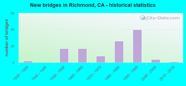
- New bridges - historical statistics
- 21930-1939
- 171950-1959
- 171960-1969
- 81970-1979
- 261980-1989
- 401990-1999
- 42000-2009
- 12010-2019

- Reconstructed bridges - Historical Statistics
- 11960-1969
- 11970-1979
- 41980-1989
- 51990-1999
- 12000-2009


- Bridge Condition - Deck
- 57.4%Good
- 14.8%Satisfactory
- 24.1%Fair
- 3.7%Poor

- Bridge Condition - Superstructure
- 64.8%Good
- 9.3%Satisfactory
- 25.9%Fair

- Bridge Condition - Substructure
- 74.1%Good
- 9.3%Satisfactory
- 16.7%Fair

- Bridge Condition - Channel
- 41.7%Excellent
- 33.3%Very good
- 16.7%Good
- 8.3%Poor

- Bridge Condition - Culverts
- 60.0%Good
- 40.0%Satisfactory
Find on map >> Show street view
Structure Number: 28 0281R, Location: 04-CC-080-5.99-RCH (Lat: 37.976228, Lng: -122.318922), Route carried "on" structure: City street , Year Built: 2009, Status: Open, Structure Length: 8.99m (29.49ft), Average Daily Traffic: 32,500 (year 2017), Truck Traffic: 1%, Average Future Daily Traffic: 32,712 (year 2041), Design Load: HL 93, Features Intersected: INTERSTATE 80, Facility Carried by Structure: HILLTOP DRIVE EB
Minimum Vertical Clearance: 30+ m (98+ ft), Kilometerpoint: 0.000, Lanes on structure: 2, Lanes under structure: 10, Owner: State Highway Agency, Approaching Roadway Width: 11.0m (36.1ft), Material/Design: Prestressed concrete continuous, Design/Construction: Box Beam or Girders - Multiple, Number Of Spans In Main Unit: 2, Length of Maximum Span: 46.9m (153.9ft), Curb or Sidewalk Widths: Left: 0.0m, Right: 1.5m (4.9ft), Curb-To-Curb Width: 11.0m (36.1ft), Out-to-Out Width: 13.3m (43.6ft)
Condition: Deck: Good, Superstructure: Fair, Substructure: Fair, Operating Rating: 42.1 metric tons, Method Used To Determine Operating Rating: Assigned ratings based on Load and Resistance Factor Design (LRFD) reported by rating factor (RF) using HL93 loadings, Inventory Rating: 32.4 metric tons, Method Used To Determine Inventory Rating: Assigned ratings based on Load and Resistance Factor Design (LRFD) reported by rating factor (RF) using HL93 loadings, Structural Evaluation: Somewhat better than minimum adequacy, Deck Geometry: Equal to present minimum criteria, Underclear: High priority of corrective action, Approach Roadway Alignment: Equal to present desirable criteria, Designated Inspection Frequency: Every 24 months, Inspection Date: July 2021, Deck Structure Type: Concrete Cast-file-Place
Find on map >> Show street view
Structure Number: 28 0287, Location: 04-CC-580-R2.09-RCH (Lat: 37.919933, Lng: -122.333178), Route carried "on" structure: City street , Year Built: 1988, Status: Open, Structure Length: 10.67m (35.01ft), Average Daily Traffic: 3,000 (year 2016), Truck Traffic: 10%, Average Future Daily Traffic: 10,760 (year 2042), Design Load: HS 20+Mod, Features Intersected: INTERSTATE ROUTE 580, Facility Carried by Structure: ERLANDSON ST
Minimum Vertical Clearance: 30+ m (98+ ft), Kilometerpoint: 0.000, Lanes on structure: 2, Lanes under structure: 8, Owner: State Highway Agency, Approaching Roadway Width: 14.6m (47.9ft), Skew: 9 degrees, Material/Design: Prestressed concrete continuous, Design/Construction: Box Beam or Girders - Multiple, Number Of Spans In Main Unit: 3, Length of Maximum Span: 39.5m (129.6ft), Curb or Sidewalk Widths: Left: 0.0m, Right: 2.4m (7.9ft), Curb-To-Curb Width: 12.2m (40.0ft), Out-to-Out Width: 15.5m (50.9ft)
Condition: Deck: Good, Superstructure: Fair, Substructure: Good, Operating Rating: 54.1 metric tons, Method Used To Determine Operating Rating: Assigned rating based on Load Factor Design (LFD) reported in metric tons, Inventory Rating: 32.4 metric tons, Method Used To Determine Inventory Rating: Assigned rating based on Load Factor Design (LFD) reported in metric tons, Structural Evaluation: Somewhat better than minimum adequacy, Deck Geometry: Equal to present minimum criteria, Underclear: Equal to present minimum criteria, Approach Roadway Alignment: Equal to present minimum criteria, Designated Inspection Frequency: Every 24 months, Inspection Date: March 2020, Deck Structure Type: Concrete Cast-file-Place
Find on map >> Show street view
Structure Number: 28 0290L, Location: 04-CC-580-R5.11-RCH (Lat: 37.929025, Lng: -122.386119), Route carried "on" structure: Interstate 580, Year Built: 1988, Status: Open, Structure Length: 11.19m (36.71ft), Average Daily Traffic: 27,500 (year 2009), Truck Traffic: 5%, Average Future Daily Traffic: 51,114 (year 2040), Design Load: HS 20+Mod, Features Intersected: CASTRO STREET
Minimum Vertical Clearance: 30+ m (98+ ft), Kilometerpoint: 5.110, Lanes on structure: 4, Lanes under structure: 5, Base Highway Network: Yes (Inventory Route: 5, Subroute: 1), Owner: State Highway Agency, Approaching Roadway Width: 19.2m (63.0ft), Skew: 9 degrees, Material/Design: Prestressed concrete continuous, Design/Construction: Box Beam or Girders - Multiple, Number Of Spans In Main Unit: 3, Length of Maximum Span: 53.6m (175.9ft), Curb-To-Curb Width: 19.2m (63.0ft), Out-to-Out Width: 20.3m (66.6ft)
Condition: Deck: Satisfactory, Superstructure: Good, Substructure: Good, Operating Rating: 54.1 metric tons, Method Used To Determine Operating Rating: Assigned rating based on Load Factor Design (LFD) reported in metric tons, Inventory Rating: 32.4 metric tons, Method Used To Determine Inventory Rating: Assigned rating based on Load Factor Design (LFD) reported in metric tons, Structural Evaluation: Better than present minimum criteria, Deck Geometry: Somewhat better than minimum adequacy, Underclear: High priority of corrective action, Approach Roadway Alignment: Equal to present desirable criteria, Designated Inspection Frequency: Every 24 months, Inspection Date: March 2020, Deck Structure Type: Concrete Cast-file-Place
Find on map >> Show street view
Structure Number: 28 0290R, Location: 04-CC-580-R5.11-RCH (Lat: 37.929147, Lng: -122.385833), Route carried "on" structure: Interstate 580, Year Built: 1990, Status: Open, Structure Length: 8.63m (28.31ft), Average Daily Traffic: 27,500 (year 2009), Truck Traffic: 5%, Average Future Daily Traffic: 51,114 (year 2040), Design Load: HS 20+Mod, Features Intersected: CASTRO STREET
Minimum Vertical Clearance: 30+ m (98+ ft), Kilometerpoint: 5.110, Lanes on structure: 3, Lanes under structure: 5, Base Highway Network: Yes (Inventory Route: 5, Subroute: 1), Owner: State Highway Agency, Approaching Roadway Width: 15.5m (50.9ft), Skew: 9 degrees, Material/Design: Prestressed concrete continuous, Design/Construction: Box Beam or Girders - Multiple, Number Of Spans In Main Unit: 4, Length of Maximum Span: 31.4m (103.0ft), Curb-To-Curb Width: 15.5m (50.9ft), Out-to-Out Width: 16.6m (54.5ft)
Condition: Deck: Satisfactory, Superstructure: Good, Substructure: Good, Operating Rating: 54.1 metric tons, Method Used To Determine Operating Rating: Assigned rating based on Load Factor Design (LFD) reported in metric tons, Inventory Rating: 32.4 metric tons, Method Used To Determine Inventory Rating: Assigned rating based on Load Factor Design (LFD) reported in metric tons, Structural Evaluation: Better than present minimum criteria, Deck Geometry: Somewhat better than minimum adequacy, Underclear: High priority of corrective action, Approach Roadway Alignment: Equal to present desirable criteria, Designated Inspection Frequency: Every 24 months, Inspection Date: March 2020, Deck Structure Type: Concrete Cast-file-Place
Find on map >> Show street view
Structure Number: 28 0290S, Location: 04-CC-580-R5.11-RCH (Lat: 37.929267, Lng: -122.385681), Route carried "on" structure: Ramp Interstate 580, Year Built: 1990, Status: Open, Structure Length: 8.62m (28.28ft), Average Daily Traffic: 500 (year 2009), Truck Traffic: 5%, Average Future Daily Traffic: 1,421 (year 2040), Design Load: HS 20+Mod, Features Intersected: CASTRO STREET
Minimum Vertical Clearance: 30+ m (98+ ft), Kilometerpoint: 5.110, Lanes on structure: 1, Lanes under structure: 4, Owner: State Highway Agency, Approaching Roadway Width: 11.1m (36.4ft), Skew: 9 degrees, Material/Design: Prestressed concrete continuous, Design/Construction: Box Beam or Girders - Multiple, Number Of Spans In Main Unit: 4, Length of Maximum Span: 32.3m (106.0ft), Curb-To-Curb Width: 11.1m (36.4ft), Out-to-Out Width: 12.2m (40.0ft)
Condition: Deck: Satisfactory, Superstructure: Good, Substructure: Good, Operating Rating: 54.1 metric tons, Method Used To Determine Operating Rating: Assigned rating based on Load Factor Design (LFD) reported in metric tons, Inventory Rating: 32.4 metric tons, Method Used To Determine Inventory Rating: Assigned rating based on Load Factor Design (LFD) reported in metric tons, Structural Evaluation: Better than present minimum criteria, Deck Geometry: Superior to present desirable criteria, Underclear: Meets minimum limits, Approach Roadway Alignment: Equal to present desirable criteria, Designated Inspection Frequency: Every 24 months, Inspection Date: March 2020, Deck Structure Type: Concrete Cast-file-Place
Find on map >> Show street view
Structure Number: 28 0292, Location: 04-CC-580-R3.60-RCH (Lat: 37.923094, Lng: -122.359919), Route carried "on" structure: City street , Year Built: 1989, Status: Open, Structure Length: 9.66m (31.69ft), Average Daily Traffic: 4,000 (year 2016), Truck Traffic: 10%, Average Future Daily Traffic: 16,139 (year 2042), Design Load: HS 20+Mod, Features Intersected: INTERSTATE 580, Facility Carried by Structure: HARBOUR WAY
Minimum Vertical Clearance: 30+ m (98+ ft), Kilometerpoint: 0.000, Lanes on structure: 5, Lanes under structure: 8, Owner: State Highway Agency, Approaching Roadway Width: 24.7m (81.0ft), Skew: 39 degrees, Material/Design: Prestressed concrete continuous, Design/Construction: Box Beam or Girders - Multiple, Number Of Spans In Main Unit: 2, Length of Maximum Span: 51.8m (169.9ft), Curb or Sidewalk Widths: Left: 1.5m (4.9ft), Right: 1.5m (4.9ft), Curb-To-Curb Width: 23.2m (76.1ft), Out-to-Out Width: 28.3m (92.8ft)
Condition: Deck: Good, Superstructure: Fair, Substructure: Good, Operating Rating: 54.1 metric tons, Method Used To Determine Operating Rating: Assigned rating based on Load Factor Design (LFD) reported in metric tons, Inventory Rating: 32.4 metric tons, Method Used To Determine Inventory Rating: Assigned rating based on Load Factor Design (LFD) reported in metric tons, Structural Evaluation: Somewhat better than minimum adequacy, Deck Geometry: Better than present minimum criteria, Underclear: Equal to present minimum criteria, Approach Roadway Alignment: Better than present minimum criteria, Designated Inspection Frequency: Every 24 months, Inspection Date: March 2020, Deck Structure Type: Concrete Cast-file-Place
Find on map >> Show street view
Structure Number: 28 0293R, Location: 04-CC-580-R5.60-RCH (Lat: 37.932328, Lng: -122.393686), Route carried "on" structure: Interstate 580, Year Built: 1985, Status: Open, Structure Length: 7.92m (25.98ft), Average Daily Traffic: 34,000 (year 2009), Truck Traffic: 5%, Average Future Daily Traffic: 59,416 (year 2040), Design Load: HS 20+Mod, Features Intersected: HILLSIDE
Minimum Vertical Clearance: 30+ m (98+ ft), Kilometerpoint: 5.600, Lanes on structure: 1, Base Highway Network: Yes (Inventory Route: 5, Subroute: 1), Owner: State Highway Agency, Approaching Roadway Width: 1.8m (5.9ft), Material/Design: Concrete continuous, Design/Construction: Slab, Number Of Spans In Main Unit: 9, Length of Maximum Span: 9.2m (30.2ft), Curb-To-Curb Width: 1.8m (5.9ft), Out-to-Out Width: 2.4m (7.9ft)
Condition: Deck: Satisfactory, Superstructure: Satisfactory, Substructure: Good, Operating Rating: 33.4 metric tons, Method Used To Determine Operating Rating: Load and Resistance Factor Rating (LRFR) rating reported by rating factor(RF) method using HL-93 loadings, Inventory Rating: 23.3 metric tons, Method Used To Determine Inventory Rating: Load and Resistance Factor Rating (LRFR) rating reported by rating factor(RF) method using HL-93 loadings, Structural Evaluation: Somewhat better than minimum adequacy, Deck Geometry: High priority of replacement, Approach Roadway Alignment: Better than present minimum criteria, Designated Inspection Frequency: Every 24 months, Inspection Date: March 2020, Deck Structure Type: Concrete Cast-file-Place
Find on map >> Show street view
Structure Number: 28 0367, Location: 04-CC-580-5.78-RCH (Lat: 37.932786, Lng: -122.396642), Route carried "on" structure: Interstate 580, Year Built: 1989, Status: Open, Structure Length: 3.20m (10.50ft), Average Daily Traffic: 68,000 (year 2009), Truck Traffic: 5%, Average Future Daily Traffic: 118,831 (year 2040), Design Load: HS 20+Mod, Features Intersected: HILLSIDE
Minimum Vertical Clearance: 30+ m (98+ ft), Kilometerpoint: 5.780, Lanes on structure: 1, Base Highway Network: Yes (Inventory Route: 5, Subroute: 1), Owner: State Highway Agency, Approaching Roadway Width: 2.4m (7.9ft), Material/Design: Concrete continuous, Design/Construction: Slab, Number Of Spans In Main Unit: 4, Length of Maximum Span: 9.1m (29.9ft), Curb-To-Curb Width: 2.4m (7.9ft), Out-to-Out Width: 2.7m (8.9ft)
Condition: Deck: Good, Superstructure: Good, Substructure: Good, Operating Rating: 54.1 metric tons, Method Used To Determine Operating Rating: Assigned rating based on Load Factor Design (LFD) reported in metric tons, Inventory Rating: 32.4 metric tons, Method Used To Determine Inventory Rating: Assigned rating based on Load Factor Design (LFD) reported in metric tons, Structural Evaluation: Better than present minimum criteria, Deck Geometry: High priority of replacement, Approach Roadway Alignment: Equal to present desirable criteria, Designated Inspection Frequency: Every 24 months, Inspection Date: March 2020, Deck Structure Type: Concrete Cast-file-Place, Wearing Surface/Protective System: Wearing Surface: Bituminous
Find on map >> Show street view
Structure Number: 28C015, Location: 0.4 MI E I-680 (Lat: 38.025811, Lng: -122.105597), Route carried "on" structure: County highway , Year Built: 1955, Status: Open, Structure Length: 1.40m (4.59ft), Average Daily Traffic: 4,185 (year 2013), Truck Traffic: 20%, Average Future Daily Traffic: 9,702 (year 2037), Design Load: HS 20, Features Intersected: PEYTON SLOUGH, Facility Carried by Structure: WATERFRONT RD
Minimum Vertical Clearance: 30+ m (98+ ft), Kilometerpoint: 0.000, Lanes on structure: 2, Owner: County Highway Agency, Approaching Roadway Width: 8.5m (27.9ft), Material/Design: Concrete continuous, Design/Construction: Slab, Number Of Spans In Main Unit: 3, Length of Maximum Span: 4.6m (15.1ft), Curb or Sidewalk Widths: Left: 0.3m (1.0ft), Right: 0.3m (1.0ft), Curb-To-Curb Width: 8.5m (27.9ft), Out-to-Out Width: 9.1m (29.9ft)
Condition: Deck: Good, Superstructure: Good, Substructure: Good, Channel: Excellent, Operating Rating: 28.8 metric tons, Method Used To Determine Operating Rating: Load Factor (LF), Inventory Rating: 17.2 metric tons, Method Used To Determine Inventory Rating: Load Factor (LF), Structural Evaluation: Meets minimum limits, Deck Geometry: Meets minimum limits, Waterway Adequacy: Better than present minimum criteria, Approach Roadway Alignment: Better than present minimum criteria, Designated Inspection Frequency: Every 24 months, Inspection Date: September 2020, Deck Structure Type: Concrete Cast-file-Place, Wearing Surface/Protective System: Wearing Surface: Bituminous
Find on map >> Show street view
Structure Number: 28C0317, Location: JUST S/O LINCOLN AVE (Lat: 37.942908, Lng: -122.358964), Route carried "on" structure: City street , Year Built: 1967, Status: Open, Structure Length: 20.48m (67.19ft), Average Daily Traffic: 5,600 (year 2012), Truck Traffic: 2%, Average Future Daily Traffic: 16,818 (year 2042), Design Load: HS 20, Features Intersected: UP RR,BNSF,AMTRAK,BARTD, Facility Carried by Structure: 13TH ST
Minimum Vertical Clearance: 30+ m (98+ ft), Kilometerpoint: 0.000, Lanes on structure: 4, Lanes under structure: 1, Owner: City or Municipal Highway Agency, Approaching Roadway Width: 19.5m (64.0ft), Skew: 24 degrees, Material/Design: Steel, Design/Construction: Stringer/Multi-beam, Number Of Spans In Main Unit: 9, Length of Maximum Span: 25.9m (85.0ft), Curb or Sidewalk Widths: Left: 0.6m (2.0ft), Right: 1.4m (4.6ft), Curb-To-Curb Width: 16.8m (55.1ft), Out-to-Out Width: 19.8m (65.0ft)
Condition: Deck: Satisfactory, Superstructure: Good, Substructure: Good, Operating Rating: 40.5 metric tons, Method Used To Determine Operating Rating: Load and Resistance Factor Rating (LRFR) rating reported by rating factor(RF) method using HL-93 loadings, Inventory Rating: 31.4 metric tons, Method Used To Determine Inventory Rating: Load and Resistance Factor Rating (LRFR) rating reported by rating factor(RF) method using HL-93 loadings, Structural Evaluation: Better than present minimum criteria, Deck Geometry: Somewhat better than minimum adequacy, Underclear: High priority of corrective action, Approach Roadway Alignment: Equal to present minimum criteria, Designated Inspection Frequency: Every 24 months, Inspection Date: December 2020, Deck Structure Type: Concrete Cast-file-Place
Find on map >> Show street view
Structure Number: 28C0321, Location: 0.2 MI S SAN PABLO AVE (Lat: 37.953186, Lng: -122.338333), Route carried "on" structure: City street , Year Built: 1960, Status: Open, Structure Length: 0.95m (3.12ft), Average Daily Traffic: 5,000 (year 2007), Truck Traffic: 2%, Average Future Daily Traffic: 8,234 (year 2042), Design Load: HS 20, Features Intersected: WILDCAT CREEK, Facility Carried by Structure: VALE RD
Minimum Vertical Clearance: 30+ m (98+ ft), Kilometerpoint: 0.000, Lanes on structure: 2, Owner: City or Municipal Highway Agency, Approaching Roadway Width: 12.2m (40.0ft), Skew: 2 degrees, Material/Design: Steel, Design/Construction: Stringer/Multi-beam, Number Of Spans In Main Unit: 1, Length of Maximum Span: 8.1m (26.6ft), Curb or Sidewalk Widths: Left: 1.8m (5.9ft), Right: 1.8m (5.9ft), Curb-To-Curb Width: 12.2m (40.0ft), Out-to-Out Width: 16.5m (54.1ft)
Condition: Deck: Fair, Superstructure: Fair, Substructure: Satisfactory, Channel: Poor, Operating Rating: 57.3 metric tons, Method Used To Determine Operating Rating: Load Factor (LF), Inventory Rating: 34.3 metric tons, Method Used To Determine Inventory Rating: Load Factor (LF), Structural Evaluation: Somewhat better than minimum adequacy, Deck Geometry: Equal to present minimum criteria, Waterway Adequacy: Better than present minimum criteria, Approach Roadway Alignment: Equal to present minimum criteria, Designated Inspection Frequency: Every 24 months, Inspection Date: December 2020, Deck Structure Type: Concrete Cast-file-Place
Find on map >> Show street view
Structure Number: 28C0419, Location: AT SAN PABLO DAM RD (Lat: 37.964869, Lng: -122.296678), Route carried "on" structure: County highway , Year Built: 1963, Status: Open, Structure Length: 0.78m (2.56ft), Average Daily Traffic: 8,468 (year 2013), Truck Traffic: 5%, Average Future Daily Traffic: 16,086 (year 2037), Features Intersected: SAN PABLO CREEK, Facility Carried by Structure: MAY ROAD
Minimum Vertical Clearance: 30+ m (98+ ft), Kilometerpoint: 0.000, Lanes on structure: 3, Owner: County Highway Agency, Approaching Roadway Width: 19.5m (64.0ft), Skew: 1 degrees, Material/Design: Concrete continuous, Design/Construction: Culvert, Number Of Spans In Main Unit: 2, Length of Maximum Span: 3.7m (12.1ft)
Condition: Channel: Excellent, Culverts: Satisfactory, Operating Rating: 40.5 metric tons, Method Used To Determine Operating Rating: Field evaluation and documented engineering judgment, Inventory Rating: 24.3 metric tons, Method Used To Determine Inventory Rating: Field evaluation and documented engineering judgment, Structural Evaluation: Equal to present minimum criteria, Waterway Adequacy: Better than present minimum criteria, Approach Roadway Alignment: Somewhat better than minimum adequacy, Designated Inspection Frequency: Every 24 months, Inspection Date: September 2020
Find on map >> Show street view
Structure Number: 28C0471, Location: 1/2 MI S OF GETRUDE AVE (Lat: 37.948533, Lng: -122.368922), Route carried "on" structure: Ramp City street , Year Built: 1995, Status: Open, Structure Length: 12.74m (41.80ft), Average Daily Traffic: 27,000 (year 2012), Truck Traffic: 5%, Average Future Daily Traffic: 29,141 (year 2042), Design Load: HS 20+Mod, Features Intersected: CASTRO ST, Facility Carried by Structure: RICHMOND PARKWAY
Minimum Vertical Clearance: 30+ m (98+ ft), Kilometerpoint: 0.000, Lanes on structure: 4, Lanes under structure: 2, Base Highway Network: Yes, Owner: City or Municipal Highway Agency, Approaching Roadway Width: 20.7m (67.9ft), Skew: 34 degrees, Material/Design: Prestressed concrete continuous, Design/Construction: Box Beam or Girders - Multiple, Number Of Spans In Main Unit: 5, Length of Maximum Span: 34.1m (111.9ft), Curb-To-Curb Width: 20.7m (67.9ft), Out-to-Out Width: 26.1m (85.6ft)
Condition: Deck: Fair, Superstructure: Fair, Substructure: Good, Operating Rating: 54.1 metric tons, Method Used To Determine Operating Rating: Assigned rating based on Load Factor Design (LFD) reported in metric tons, Inventory Rating: 32.4 metric tons, Method Used To Determine Inventory Rating: Assigned rating based on Load Factor Design (LFD) reported in metric tons, Structural Evaluation: Somewhat better than minimum adequacy, Deck Geometry: Superior to present desirable criteria, Underclear: Superior to present desirable criteria, Approach Roadway Alignment: Equal to present desirable criteria, Designated Inspection Frequency: Every 24 months, Inspection Date: December 2020, Deck Structure Type: Concrete Cast-file-Place
Find on map >> Show street view
Structure Number: 28C0472, Location: INTCHG RICHMOND/GIANT RD (Lat: 37.981758, Lng: -122.348889), Route carried "on" structure: County highway , Year Built: 1995, Status: Open, Structure Length: 3.96m (12.99ft), Average Daily Traffic: 22,244 (year 2012), Truck Traffic: 5%, Average Future Daily Traffic: 33,040 (year 2042), Design Load: HS 20+Mod, Features Intersected: GIANT HIGHWAY, Facility Carried by Structure: RICHMOND PARKWAY
Minimum Vertical Clearance: 30+ m (98+ ft), Kilometerpoint: 0.000, Lanes on structure: 8, Lanes under structure: 2, Base Highway Network: Yes, Owner: City or Municipal Highway Agency, Approaching Roadway Width: 37.2m (122.0ft), Skew: 30 degrees, Material/Design: Prestressed concrete, Design/Construction: Box Beam or Girders - Multiple, Number Of Spans In Main Unit: 1, Length of Maximum Span: 38.3m (125.7ft), Curb-To-Curb Width: 37.2m (122.0ft), Out-to-Out Width: 41.9m (137.5ft)
Condition: Deck: Fair, Superstructure: Good, Substructure: Good, Operating Rating: 54.1 metric tons, Method Used To Determine Operating Rating: Assigned rating based on Load Factor Design (LFD) reported in metric tons, Inventory Rating: 32.4 metric tons, Method Used To Determine Inventory Rating: Assigned rating based on Load Factor Design (LFD) reported in metric tons, Structural Evaluation: Better than present minimum criteria, Deck Geometry: Superior to present desirable criteria, Underclear: Meets minimum limits, Approach Roadway Alignment: Equal to present desirable criteria, Designated Inspection Frequency: Every 24 months, Inspection Date: December 2020, Deck Structure Type: Concrete Cast-file-Place
Find on map >> Show street view
Structure Number: 28C0473, Location: 1 MI S OF RICHMOND PKWY (Lat: 37.937142, Lng: -122.378558), Route carried "on" structure: City street , Year Built: 1995, Status: Open, Structure Length: 6.52m (21.39ft), Average Daily Traffic: 27,000 (year 2012), Truck Traffic: 5%, Average Future Daily Traffic: 28,565 (year 2036), Design Load: HS 20+Mod, Features Intersected: CHEVRON RAILROAD TRACKS, Facility Carried by Structure: CASTRO STREET
Minimum Vertical Clearance: 30+ m (98+ ft), Kilometerpoint: 0.000, Lanes on structure: 4, Base Highway Network: Yes, Owner: City or Municipal Highway Agency, Approaching Roadway Width: 20.7m (67.9ft), Skew: 33 degrees, Material/Design: Prestressed concrete continuous, Design/Construction: Box Beam or Girders - Multiple, Number Of Spans In Main Unit: 3, Length of Maximum Span: 29.7m (97.4ft), Curb or Sidewalk Widths: Left: 1.5m (4.9ft), Right: 0.0m, Curb-To-Curb Width: 20.7m (67.9ft), Out-to-Out Width: 23.7m (77.8ft)
Condition: Deck: Good, Superstructure: Good, Substructure: Good, Operating Rating: 54.1 metric tons, Method Used To Determine Operating Rating: Assigned rating based on Load Factor Design (LFD) reported in metric tons, Inventory Rating: 32.4 metric tons, Method Used To Determine Inventory Rating: Assigned rating based on Load Factor Design (LFD) reported in metric tons, Structural Evaluation: Better than present minimum criteria, Deck Geometry: Equal to present minimum criteria, Underclear: Equal to present minimum criteria, Approach Roadway Alignment: Equal to present desirable criteria, Designated Inspection Frequency: Every 48 months, Inspection Date: December 2018, Deck Structure Type: Concrete Cast-file-Place
Find on map >> Show street view
Structure Number: 28C0474L, Location: 3 MI SW OF I-80 (Lat: 37.976603, Lng: -122.358803), Route carried "on" structure: County highway , Year Built: 1995, Status: Open, Structure Length: 71.75m (235.40ft), Average Daily Traffic: 27,000 (year 2012), Truck Traffic: 5%, Average Future Daily Traffic: 29,141 (year 2042), Design Load: HS 20+Mod, Features Intersected: GIANT,UP RR,BNSF,AMTRAK, Facility Carried by Structure: RICHMOND PKWY SB
Minimum Vertical Clearance: 30+ m (98+ ft), Kilometerpoint: 0.000, Lanes on structure: 2, Lanes under structure: 5, Base Highway Network: Yes, Owner: City or Municipal Highway Agency, Approaching Roadway Width: 11.3m (37.1ft), Skew: 9 degrees, Material/Design: Prestressed concrete continuous, Design/Construction: Box Beam or Girders - Multiple, Number Of Spans In Main Unit: 24, Length of Maximum Span: 43.3m (142.1ft), Curb-To-Curb Width: 11.3m (37.1ft), Out-to-Out Width: 12.3m (40.4ft)
Condition: Deck: Poor, Superstructure: Good, Substructure: Good, Channel: Excellent, Operating Rating: 54.1 metric tons, Method Used To Determine Operating Rating: Assigned rating based on Load Factor Design (LFD) reported in metric tons, Inventory Rating: 32.4 metric tons, Method Used To Determine Inventory Rating: Assigned rating based on Load Factor Design (LFD) reported in metric tons, Structural Evaluation: Better than present minimum criteria, Deck Geometry: Somewhat better than minimum adequacy, Underclear: High priority of corrective action, Waterway Adequacy: Equal to present desirable criteria, Approach Roadway Alignment: Equal to present desirable criteria, Designated Inspection Frequency: Every 24 months, Inspection Date: December 2020, Deck Structure Type: Concrete Cast-file-Place
Find on map >> Show street view
Structure Number: 28C0474R, Location: 3 MI SW OF I-80 (Lat: 37.976336, Lng: -122.358831), Route carried "on" structure: County highway , Year Built: 1995, Status: Open, Structure Length: 71.75m (235.40ft), Average Daily Traffic: 27,000 (year 2012), Truck Traffic: 5%, Average Future Daily Traffic: 29,141 (year 2042), Design Load: HS 20+Mod, Features Intersected: GIANT,UP RR,BNSF,AMTRAK, Facility Carried by Structure: RICHMOND PKWY NB
Minimum Vertical Clearance: 30+ m (98+ ft), Kilometerpoint: 0.000, Lanes on structure: 2, Lanes under structure: 5, Base Highway Network: Yes, Owner: City or Municipal Highway Agency, Approaching Roadway Width: 11.3m (37.1ft), Skew: 9 degrees, Material/Design: Prestressed concrete continuous, Design/Construction: Box Beam or Girders - Multiple, Number Of Spans In Main Unit: 24, Length of Maximum Span: 43.3m (142.1ft), Curb-To-Curb Width: 11.3m (37.1ft), Out-to-Out Width: 12.3m (40.4ft)
Condition: Deck: Poor, Superstructure: Fair, Substructure: Good, Channel: Excellent, Operating Rating: 54.1 metric tons, Method Used To Determine Operating Rating: Assigned rating based on Load Factor Design (LFD) reported in metric tons, Inventory Rating: 32.4 metric tons, Method Used To Determine Inventory Rating: Assigned rating based on Load Factor Design (LFD) reported in metric tons, Structural Evaluation: Somewhat better than minimum adequacy, Deck Geometry: Somewhat better than minimum adequacy, Underclear: High priority of corrective action, Waterway Adequacy: Equal to present desirable criteria, Approach Roadway Alignment: Equal to present desirable criteria, Length Of Structure Improvement: 71.75m (235.40ft), Designated Inspection Frequency: Every 24 months, Inspection Date: December 2020, Bridge Improvement Cost: $9,070,000, Roadway Improvement Cost: $1,814,000, Total Project Cost: $15,237,000 ( Estimate for 2021), Deck Structure Type: Concrete Cast-file-Place
Find on map >> Show street view
Structure Number: 28C0475, Location: 3.6 MI SW OF I-80 (Lat: 37.972606, Lng: -122.369289), Route carried "on" structure: County highway , Year Built: 1995, Status: Open, Structure Length: 0.75m (2.46ft), Average Daily Traffic: 27,000 (year 2012), Truck Traffic: 5%, Average Future Daily Traffic: 28,851 (year 2038), Features Intersected: PARKWAY WETLANDS, Facility Carried by Structure: RICHMOND PARKWAY
Minimum Vertical Clearance: 30+ m (98+ ft), Kilometerpoint: 0.000, Lanes on structure: 4, Base Highway Network: Yes, Owner: City or Municipal Highway Agency, Approaching Roadway Width: 30.5m (100.1ft), Skew: 24 degrees, Material/Design: Concrete continuous, Design/Construction: Culvert, Number Of Spans In Main Unit: 3, Length of Maximum Span: 2.5m (8.2ft), Curb or Sidewalk Widths: Left: 0.8m (2.6ft), Right: 0.8m (2.6ft), Curb-To-Curb Width: 22.6m (74.1ft), Out-to-Out Width: 37.5m (123.0ft)
Condition: Channel: Very good, Culverts: Good, Operating Rating: 54.1 metric tons, Method Used To Determine Operating Rating: Field evaluation and documented engineering judgment, Inventory Rating: 32.4 metric tons, Method Used To Determine Inventory Rating: Field evaluation and documented engineering judgment, Structural Evaluation: Better than present minimum criteria, Deck Geometry: Superior to present desirable criteria, Waterway Adequacy: Equal to present desirable criteria, Approach Roadway Alignment: Equal to present desirable criteria, Designated Inspection Frequency: Every 48 months, Inspection Date: December 2020
Find on map >> Show street view
Structure Number: 28C0491, Location: 0.1 MI EAST OF I-80 (Lat: 37.965742, Lng: -122.320553), Route carried "on" structure: City street , Year Built: 2013, Status: Open, Structure Length: 0.61m (2.00ft), Average Daily Traffic: 10,500 (year 2010), Truck Traffic: 6%, Average Future Daily Traffic: 24,069 (year 2040), Features Intersected: SAN PABLO CREEK, Facility Carried by Structure: EL PORTAL DRIVE
Minimum Vertical Clearance: 30+ m (98+ ft), Kilometerpoint: 0.000, Lanes on structure: 4, Owner: City or Municipal Highway Agency, Approaching Roadway Width: 17.7m (58.1ft), Skew: 9 degrees, Material/Design: Concrete, Design/Construction: Culvert, Number Of Spans In Main Unit: 1, Length of Maximum Span: 6.1m (20.0ft), Curb or Sidewalk Widths: Left: 1.5m (4.9ft), Right: 1.5m (4.9ft)
Condition: Channel: Good, Culverts: Good, Operating Rating: 54.1 metric tons, Method Used To Determine Operating Rating: Field evaluation and documented engineering judgment, Inventory Rating: 32.4 metric tons, Method Used To Determine Inventory Rating: Field evaluation and documented engineering judgment, Structural Evaluation: Better than present minimum criteria, Waterway Adequacy: Better than present minimum criteria, Approach Roadway Alignment: Equal to present desirable criteria, Designated Inspection Frequency: Every 48 months, Inspection Date: December 2018
Find on map >> Show street view
Structure Number: 28 0056J, Location: 04-CC-580-R4.82-RCH (Lat: 37.927250, Lng: -122.381161), Route carried "under" structure: City street , Year Built: 1991, Structure Length: 0. m, Average Daily Traffic: 3,000 (year 2009), Truck Traffic: 5%, Features Intersected: BNSF RY & GARRARD BLVD, Facility Carried by Structure: I 580 EB OFF RAMP
Minimum Vertical Clearance: 5.70m (18.70ft), Kilometerpoint: 0.000, Lanes on structure: 1, Lanes under structure: 4, Material/Design: Prestressed concrete continuous, Design/Construction: Box Beam or Girders - Multiple, Length of Maximum Span: 33.5m (109.9ft)
Find on map >> Show street view
Structure Number: 28 0056K, Location: 04-CC-580-R4.82-RCH (Lat: 37.927183, Lng: -122.381306), Route carried "under" structure: City street , Year Built: 1980, Structure Length: 0. m, Average Daily Traffic: 3,000 (year 2009), Truck Traffic: 5%, Features Intersected: BNSF RY & GARRARD BLVD, Facility Carried by Structure: EB ONRAMP
Minimum Vertical Clearance: 5.10m (16.73ft), Kilometerpoint: 0.000, Lanes on structure: 1, Lanes under structure: 4, Material/Design: Prestressed concrete continuous, Design/Construction: Box Beam or Girders - Multiple, Length of Maximum Span: 39.6m (129.9ft)
Find on map >> Show street view
Structure Number: 28 0056L, Location: 04-CC-580-R4.82-RCH (Lat: 37.927475, Lng: -122.380953), Route carried "under" structure: City street , Year Built: 1980, Structure Length: 0. m, Average Daily Traffic: 3,000 (year 2016), Truck Traffic: 5%, Features Intersected: BNSF RY & GARRARD BLVD, Facility Carried by Structure: I 580 EB
Minimum Vertical Clearance: 7.59m (24.90ft), Kilometerpoint: 0.000, Lanes on structure: 4, Lanes under structure: 4, Material/Design: Prestressed concrete continuous, Design/Construction: Box Beam or Girders - Multiple, Length of Maximum Span: 41.1m (134.8ft)
Find on map >> Show street view
Structure Number: 28 0056R, Location: 04-CC-580-R4.81-RCH (Lat: 37.927658, Lng: -122.380800), Route carried "under" structure: City street , Year Built: 1991, Structure Length: 0. m, Average Daily Traffic: 3,000 (year 2016), Truck Traffic: 5%, Features Intersected: BNSF RY & GARRARD BLVD, Facility Carried by Structure: I 580 WB
Minimum Vertical Clearance: 6.89m (22.60ft), Kilometerpoint: 0.000, Lanes on structure: 3, Lanes under structure: 4, Material/Design: Prestressed concrete continuous, Design/Construction: Box Beam or Girders - Multiple, Length of Maximum Span: 41.1m (134.8ft)
Find on map >> Show street view
Structure Number: 28 0056S, Location: 04-CC-580-R4.81-RCH (Lat: 37.927869, Lng: -122.380714), Route carried "under" structure: City street , Year Built: 1980, Structure Length: 0. m, Average Daily Traffic: 3,000 (year 2016), Truck Traffic: 5%, Features Intersected: BNSF RY & GARRARD BLVD, Facility Carried by Structure: CANAL BL-W580 ONRP
Minimum Vertical Clearance: 5.63m (18.47ft), Kilometerpoint: 0.000, Lanes on structure: 2, Lanes under structure: 4, Material/Design: Prestressed concrete continuous, Design/Construction: Box Beam or Girders - Multiple, Length of Maximum Span: 45.7m (149.9ft)
Find on map >> Show street view
Structure Number: 28 0080L, Location: 04-CC-080-2.04-RCH (Lat: 37.925183, Lng: -122.320786), Route carried "under" structure: City street , Year Built: 1997, Structure Length: 0. m, Average Daily Traffic: 17,799 (year 1999), Truck Traffic: 5%, Features Intersected: CUTTING BLVD, Facility Carried by Structure: INTERSTATE 80 WB
Minimum Vertical Clearance: 4.70m (15.42ft), Kilometerpoint: 0.000, Lanes on structure: 4, Lanes under structure: 4, Material/Design: Concrete, Design/Construction: Stringer/Multi-beam, Length of Maximum Span: 31.6m (103.7ft)
Find on map >> Show street view
Structure Number: 28 0080R, Location: 04-CC-080-2.04-RCH (Lat: 37.925150, Lng: -122.320219), Route carried "under" structure: City street , Year Built: 1997, Structure Length: 0. m, Average Daily Traffic: 17,799 (year 1999), Truck Traffic: 5%, Features Intersected: CUTTING BLVD, Facility Carried by Structure: INTERSTATE 80 EB
Minimum Vertical Clearance: 4.69m (15.39ft), Kilometerpoint: 0.000, Lanes on structure: 5, Lanes under structure: 4, Material/Design: Concrete, Design/Construction: Stringer/Multi-beam, Length of Maximum Span: 31.4m (103.0ft)
Find on map >> Show street view
Structure Number: 28 0082, Location: 04-CC-080-2.62-RCH (Lat: 37.932489, Lng: -122.325556), Route carried "under" structure: Ramp Interstate 80, Year Built: 1956, Structure Length: 0. m, Average Daily Traffic: 16,300 (year 2000), Truck Traffic: 5%, Features Intersected: MACDONALD AVE & E80 OFF
Minimum Vertical Clearance: 4.55m (14.93ft), Kilometerpoint: 2.620, Lanes on structure: 10, Lanes under structure: 1, Material/Design: Concrete, Design/Construction: Box Beam or Girders - Multiple, Length of Maximum Span: 37.4m (122.7ft)
Find on map >> Show street view
Structure Number: 28 0082, Location: 04-CC-080-2.62-RCH (Lat: 37.932489, Lng: -122.325556), Route carried "under" structure: City street , Year Built: 1956, Structure Length: 0. m, Average Daily Traffic: 16,300 (year 1998), Truck Traffic: 5%, Features Intersected: MACDONALD AVE & E80 OFF, Facility Carried by Structure: INTERSTATE 80
Minimum Vertical Clearance: 4.55m (14.93ft), Kilometerpoint: 0.000, Lanes on structure: 10, Lanes under structure: 4, Material/Design: Concrete, Design/Construction: Box Beam or Girders - Multiple, Length of Maximum Span: 37.4m (122.7ft)
Find on map >> Show street view
Structure Number: 28 0082S, Location: 04-CC-080-2.59-RCH (Lat: 37.932264, Lng: -122.325283), Route carried "under" structure: City street , Year Built: 1979, Structure Length: 0. m, Average Daily Traffic: 16,300 (year 1998), Truck Traffic: 3%, Features Intersected: MACDONALD AVE & E80 OFF, Facility Carried by Structure: E80-MACDONALD OFF
Minimum Vertical Clearance: 4.98m (16.34ft), Kilometerpoint: 0.000, Lanes on structure: 1, Lanes under structure: 4, Material/Design: Prestressed concrete continuous, Design/Construction: Box Beam or Girders - Multiple, Length of Maximum Span: 33.5m (109.9ft)
Find on map >> Show street view
Structure Number: 28 0082S, Location: 04-CC-080-2.59-RCH (Lat: 37.932264, Lng: -122.325283), Route carried "under" structure: Ramp Interstate 80, Year Built: 1979, Structure Length: 0. m, Average Daily Traffic: 16,300 (year 2000), Truck Traffic: 3%, Features Intersected: MACDONALD AVE & E80 OFF
Minimum Vertical Clearance: 5.02m (16.47ft), Kilometerpoint: 2.590, Lanes on structure: 1, Lanes under structure: 1, Material/Design: Prestressed concrete continuous, Design/Construction: Box Beam or Girders - Multiple, Length of Maximum Span: 33.5m (109.9ft)
Find on map >> Show street view
Structure Number: 28 0083, Location: 04-CC-080-2.82-RCH (Lat: 37.935294, Lng: -122.326625), Route carried "under" structure: City street , Year Built: 1956, Structure Length: 0. m, Average Daily Traffic: 14,266 (year 1998), Truck Traffic: 3%, Features Intersected: BARRETT AVENUE, Facility Carried by Structure: INTERSTATE 80
Minimum Vertical Clearance: 4.67m (15.32ft), Kilometerpoint: 0.000, Lanes on structure: 8, Lanes under structure: 5, Material/Design: Concrete continuous, Design/Construction: Box Beam or Girders - Multiple, Length of Maximum Span: 21.5m (70.5ft)
Find on map >> Show street view
Structure Number: 28 0083S, Location: 04-CC-080-2.82-RCH (Lat: 37.935333, Lng: -122.326439), Route carried "under" structure: City street , Year Built: 1997, Structure Length: 0. m, Average Daily Traffic: 14,266 (year 1998), Truck Traffic: 3%, Features Intersected: BARRETT AVENUE, Facility Carried by Structure: E80-SAN PABLO OFF
Minimum Vertical Clearance: 4.55m (14.93ft), Kilometerpoint: 0.000, Lanes on structure: 1, Lanes under structure: 5, Material/Design: Prestressed concrete, Design/Construction: Stringer/Multi-beam, Length of Maximum Span: 35.1m (115.2ft)
Find on map >> Show street view
Structure Number: 28 0084, Location: 04-CC-080-2.96-RCH (Lat: 37.937008, Lng: -122.326019), Route carried "under" structure: City street , Year Built: 1956, Structure Length: 0. m, Average Daily Traffic: 14,700 (year 1998), Truck Traffic: 3%, Features Intersected: SAN PABLO AVENUE, Facility Carried by Structure: INTERSTATE 80
Minimum Vertical Clearance: 4.49m (14.73ft), Kilometerpoint: 0.000, Lanes on structure: 8, Lanes under structure: 5, Material/Design: Concrete, Design/Construction: Box Beam or Girders - Multiple, Length of Maximum Span: 39.5m (129.6ft)
Find on map >> Show street view
Structure Number: 28 0084K, Location: 04-CC-080-2.97-RCH (Lat: 37.937647, Lng: -122.326428), Route carried "under" structure: City street , Year Built: 1964, Structure Length: 0. m, Average Daily Traffic: 14,700 (year 1998), Truck Traffic: 3%, Features Intersected: SAN PABLO AVENUE, Facility Carried by Structure: W80-BARRETT OFFRMP
Minimum Vertical Clearance: 4.90m (16.08ft), Kilometerpoint: 0.000, Lanes on structure: 1, Lanes under structure: 5, Material/Design: Concrete, Design/Construction: Box Beam or Girders - Multiple, Length of Maximum Span: 42.4m (139.1ft)
Find on map >> Show street view
Structure Number: 28 0085, Location: 04-CC-080-3.40-RCH (Lat: 37.943269, Lng: -122.324083), Route carried "under" structure: Interstate 80, Year Built: 1997, Structure Length: 0. m, Average Daily Traffic: 179,000 (year 2009), Truck Traffic: 3%, Features Intersected: INTERSTATE 80, Facility Carried by Structure: SOLANO AVENUE
Minimum Vertical Clearance: 5.66m (18.57ft), Kilometerpoint: 3.400, Lanes on structure: 2, Lanes under structure: 8, Material/Design: Prestressed concrete continuous, Design/Construction: Box Beam or Girders - Multiple, Length of Maximum Span: 32.9m (107.9ft)
Find on map >> Show street view
Structure Number: 28 0087, Location: 04-CC-080-3.80-RCH (Lat: 37.948492, Lng: -122.326322), Route carried "under" structure: Interstate 80, Year Built: 1997, Structure Length: 0. m, Average Daily Traffic: 179,000 (year 2009), Truck Traffic: 3%, Features Intersected: INTERSTATE 80, Facility Carried by Structure: MCBRYDE AVENUE
Minimum Vertical Clearance: 5.21m (17.09ft), Kilometerpoint: 3.800, Lanes on structure: 4, Lanes under structure: 8, Material/Design: Prestressed concrete continuous, Design/Construction: Box Beam or Girders - Multiple, Length of Maximum Span: 30.2m (99.1ft)
Find on map >> Show street view
Structure Number: 28 0114, Location: 04-CC-080-0.22-RCH (Lat: 37.900708, Lng: -122.310389), Route carried "under" structure: City street , Year Built: 1958, Structure Length: 0. m, Average Daily Traffic: 21,808 (year 1998), Truck Traffic: 5%, Features Intersected: CENTRAL AVENUE, Facility Carried by Structure: INTERSTATE 80
Minimum Vertical Clearance: 4.52m (14.83ft), Kilometerpoint: 0.000, Lanes on structure: 8, Lanes under structure: 5, Material/Design: Prestressed concrete, Design/Construction: Tee Beam, Length of Maximum Span: 20.1m (65.9ft)
Find on map >> Show street view
Structure Number: 28 0123, Location: 04-CC-080-1.00-RCH (Lat: 37.910600, Lng: -122.316925), Route carried "under" structure: City street , Year Built: 1960, Structure Length: 0. m, Average Daily Traffic: 11,475 (year 1999), Truck Traffic: 5%, Features Intersected: CARLSON BLVD, Facility Carried by Structure: INTERSTATE 80
Minimum Vertical Clearance: 4.57m (14.99ft), Kilometerpoint: 0.000, Lanes on structure: 8, Lanes under structure: 4, Material/Design: Concrete continuous, Design/Construction: Box Beam or Girders - Multiple, Length of Maximum Span: 19.4m (63.6ft)
Find on map >> Show street view
Structure Number: 28 0141R, Location: 04-CC-580-6.01-RCH (Lat: 37.932206, Lng: -122.401203), Route carried "under" structure: Ramp Interstate 580, Year Built: 1956, Structure Length: 0. m, Average Daily Traffic: 3,000 (year 2009), Truck Traffic: 5%, Features Intersected: STENMARK DR SB ON-RAMP
Minimum Vertical Clearance: 4.29m (14.07ft), Kilometerpoint: 6.010, Lanes on structure: 3, Lanes under structure: 1, Material/Design: Steel continuous, Design/Construction: Stringer/Multi-beam, Length of Maximum Span: 18.3m (60.0ft)
Find on map >> Show street view
Structure Number: 28 0156, Location: 04-CC-080-0.50-RCH (Lat: 37.904092, Lng: -122.313336), Route carried "under" structure: Interstate 80, Year Built: 1996, Structure Length: 0. m, Average Daily Traffic: 179,000 (year 2009), Truck Traffic: 3%, Features Intersected: INTERSTATE 80, Facility Carried by Structure: PEDESTRIAN WALKWAY
Minimum Vertical Clearance: 5.64m (18.50ft), Kilometerpoint: 0.500, Lanes under structure: 8, Material/Design: Concrete continuous, Design/Construction: Box Beam or Girders - Single/Spread, Length of Maximum Span: 29.4m (96.5ft)
Find on map >> Show street view
Structure Number: 28 0231, Location: 04-CC-580-0.24-RCH (Lat: 37.899875, Lng: -122.314397), Route carried "under" structure: Interstate 580, Year Built: 1991, Structure Length: 0. m, Average Daily Traffic: 84,500 (year 2009), Features Intersected: INTERSTATE 580, Facility Carried by Structure: CENTRAL AVENUE
Minimum Vertical Clearance: 6.43m (21.10ft), Kilometerpoint: 0.240, Lanes on structure: 4, Lanes under structure: 6, Material/Design: Prestressed concrete continuous, Design/Construction: Box Beam or Girders - Multiple, Length of Maximum Span: 29.1m (95.5ft)
Find on map >> Show street view
Structure Number: 28 0271, Location: 04-CC-580-1.21 (Lat: 37.911189, Lng: -122.325050), Route carried "under" structure: Interstate 580, Year Built: 1987, Structure Length: 0. m, Average Daily Traffic: 84,500 (year 2009), Features Intersected: INTERSTATE 580, Facility Carried by Structure: BAYVIEW AVENUE OC
Minimum Vertical Clearance: 10.06m (33.01ft), Kilometerpoint: 1.210, Lanes on structure: 4, Lanes under structure: 6, Material/Design: Prestressed concrete continuous, Design/Construction: Box Beam or Girders - Multiple, Length of Maximum Span: 38.4m (126.0ft)
Find on map >> Show street view
Structure Number: 28 0273, Location: 04-CC-580-R2.89-RCH (Lat: 37.921544, Lng: -122.347317), Route carried "under" structure: Interstate 580, Year Built: 1987, Structure Length: 0. m, Average Daily Traffic: 87,000 (year 2009), Truck Traffic: 5%, Features Intersected: INTERSTATE 580, Facility Carried by Structure: SOUTH 23RD ST
Minimum Vertical Clearance: 5.26m (17.26ft), Kilometerpoint: 2.890, Lanes on structure: 6, Lanes under structure: 8, Material/Design: Prestressed concrete continuous, Design/Construction: Box Beam or Girders - Multiple, Length of Maximum Span: 36.6m (120.1ft)
Find on map >> Show street view
Structure Number: 28 0274, Location: 04-CC-580-R3.35-RCH (Lat: 37.921678, Lng: -122.355772), Route carried "under" structure: Interstate 580, Year Built: 1989, Structure Length: 0. m, Average Daily Traffic: 87,000 (year 2009), Truck Traffic: 5%, Features Intersected: INTERSTATE 580, Facility Carried by Structure: MARINA WAY OC
Minimum Vertical Clearance: 5.13m (16.83ft), Kilometerpoint: 3.350, Lanes on structure: 4, Lanes under structure: 8, Material/Design: Prestressed concrete continuous, Design/Construction: Box Beam or Girders - Multiple, Length of Maximum Span: 37.5m (123.0ft)
Find on map >> Show street view
Structure Number: 28 0276, Location: 04-CC-580-R3.79-RCH (Lat: 37.925133, Lng: -122.363119), Route carried "under" structure: Interstate 580, Year Built: 1989, Structure Length: 0. m, Average Daily Traffic: 69,000 (year 2009), Features Intersected: INTERSTATE 580, Facility Carried by Structure: CUTTING BLVD
Minimum Vertical Clearance: 5.33m (17.49ft), Kilometerpoint: 3.790, Lanes on structure: 5, Lanes under structure: 6, Material/Design: Prestressed concrete continuous, Design/Construction: Box Beam or Girders - Multiple, Length of Maximum Span: 47.2m (154.9ft)
Find on map >> Show street view
Structure Number: 28 0277, Location: 04-CC-580-R4.09-RCH (Lat: 37.927206, Lng: -122.367744), Route carried "under" structure: City street , Year Built: 1990, Structure Length: 0. m, Average Daily Traffic: 3,000 (year 2016), Truck Traffic: 5%, Features Intersected: BNSF RY, SOUTH SECOND ST, Facility Carried by Structure: INTERSTATE 580
Minimum Vertical Clearance: 6.10m (20.01ft), Kilometerpoint: 0.000, Lanes on structure: 8, Lanes under structure: 2, Material/Design: Prestressed concrete continuous, Design/Construction: Box Beam or Girders - Multiple, Length of Maximum Span: 35.4m (116.1ft)
Find on map >> Show street view
Structure Number: 28 0278, Location: 04-CC-580-R4.64-RCH (Lat: 37.927300, Lng: -122.377889), Route carried "under" structure: City street , Year Built: 1991, Structure Length: 0. m, Average Daily Traffic: 1,200 (year 2016), Truck Traffic: 5%, Features Intersected: CANAL BOULEVARD, Facility Carried by Structure: INTERSTATE 580
Minimum Vertical Clearance: 5.51m (18.08ft), Kilometerpoint: 0.000, Lanes on structure: 7, Lanes under structure: 5, Material/Design: Prestressed concrete continuous, Design/Construction: Box Beam or Girders - Multiple, Length of Maximum Span: 32.1m (105.3ft)
Find on map >> Show street view
Structure Number: 28 0281L, Location: 04-CC-080-5.99-RCH (Lat: 37.976353, Lng: -122.318872), Route carried "under" structure: Interstate 80, Year Built: 1977, Structure Length: 0. m, Average Daily Traffic: 179,000 (year 2019), Truck Traffic: 3%, Features Intersected: INTERSTATE 80, Facility Carried by Structure: HILLTOP DRIVE WB
Minimum Vertical Clearance: 7.09m (23.26ft), Kilometerpoint: 5.990, Lanes on structure: 2, Lanes under structure: 8, Material/Design: Prestressed concrete continuous, Design/Construction: Box Beam or Girders - Multiple, Length of Maximum Span: 45.7m (149.9ft)
Find on map >> Show street view
Structure Number: 28 0281L, Location: 04-CC-080-5.99-RCH (Lat: 37.976353, Lng: -122.318872), Route carried "under" structure: Ramp Other road , Year Built: 1977, Structure Length: 0. m, Average Daily Traffic: 2,850 (year 2019), Truck Traffic: 8%, Features Intersected: INTERSTATE 80, Facility Carried by Structure: HILLTOP DRIVE WB
Minimum Vertical Clearance: 7.11m (23.33ft), Kilometerpoint: 0.000, Lanes on structure: 2, Lanes under structure: 1, Material/Design: Prestressed concrete continuous, Design/Construction: Box Beam or Girders - Multiple, Length of Maximum Span: 45.7m (149.9ft)
Find on map >> Show street view
Structure Number: 28 0281L, Location: 04-CC-080-5.99-RCH (Lat: 37.976353, Lng: -122.318872), Route carried "under" structure: Ramp Other road , Year Built: 1977, Structure Length: 0. m, Average Daily Traffic: 3,000 (year 2019), Truck Traffic: 8%, Features Intersected: INTERSTATE 80, Facility Carried by Structure: HILLTOP DRIVE WB
Minimum Vertical Clearance: 7.92m (25.98ft), Kilometerpoint: 0.000, Lanes on structure: 2, Lanes under structure: 1, Material/Design: Prestressed concrete continuous, Design/Construction: Box Beam or Girders - Multiple, Length of Maximum Span: 45.7m (149.9ft)
Find on map >> Show street view
Structure Number: 28 0281R, Location: 04-CC-080-5.99-RCH (Lat: 37.976228, Lng: -122.318922), Route carried "under" structure: Interstate 80, Year Built: 2009, Structure Length: 0. m, Average Daily Traffic: 179,000 (year 2019), Truck Traffic: 3%, Features Intersected: INTERSTATE 80, Facility Carried by Structure: HILLTOP DRIVE EB
Minimum Vertical Clearance: 7.14m (23.43ft), Kilometerpoint: 5.990, Lanes on structure: 2, Lanes under structure: 8, Material/Design: Prestressed concrete continuous, Design/Construction: Box Beam or Girders - Multiple, Length of Maximum Span: 46.9m (153.9ft)
Find on map >> Show street view
Structure Number: 28 0281R, Location: 04-CC-080-5.99-RCH (Lat: 37.976228, Lng: -122.318922), Route carried "under" structure: Ramp Other road , Year Built: 2009, Structure Length: 0. m, Average Daily Traffic: 3,000 (year 2019), Truck Traffic: 8%, Features Intersected: INTERSTATE 80, Facility Carried by Structure: HILLTOP DRIVE EB
Minimum Vertical Clearance: 8.00m (26.25ft), Kilometerpoint: 0.000, Lanes on structure: 2, Lanes under structure: 1, Material/Design: Prestressed concrete continuous, Design/Construction: Box Beam or Girders - Multiple, Length of Maximum Span: 46.9m (153.9ft)
Find on map >> Show street view
Structure Number: 28 0281R, Location: 04-CC-080-5.99-RCH (Lat: 37.976228, Lng: -122.318922), Route carried "under" structure: Ramp Other road , Year Built: 2009, Structure Length: 0. m, Average Daily Traffic: 3,000 (year 2019), Truck Traffic: 8%, Features Intersected: INTERSTATE 80, Facility Carried by Structure: HILLTOP DRIVE EB
Minimum Vertical Clearance: 7.14m (23.43ft), Kilometerpoint: 0.000, Lanes on structure: 2, Lanes under structure: 1, Material/Design: Prestressed concrete continuous, Design/Construction: Box Beam or Girders - Multiple, Length of Maximum Span: 46.9m (153.9ft)
Find on map >> Show street view
Structure Number: 28 0285, Location: 04-CC-580-R2.00-RCH (Lat: 37.919497, Lng: -122.332428), Route carried "under" structure: Interstate 580, Year Built: 1988, Structure Length: 0. m, Average Daily Traffic: 87,000 (year 2009), Truck Traffic: 5%, Features Intersected: INTERSTATE 580, Facility Carried by Structure: BNSF RY
Minimum Vertical Clearance: 5.64m (18.50ft), Kilometerpoint: 2.000, Lanes under structure: 8, Material/Design: Prestressed concrete continuous, Design/Construction: Stringer/Multi-beam, Length of Maximum Span: 46.6m (152.9ft)
Find on map >> Show street view
Structure Number: 28 0286, Location: 04-CC-580-R2.06-RCH (Lat: 37.919689, Lng: -122.332817), Route carried "under" structure: Interstate 580, Year Built: 1988, Structure Length: 0. m, Average Daily Traffic: 87,000 (year 2009), Truck Traffic: 5%, Features Intersected: INTERSTATE 580, Facility Carried by Structure: BNSF RY
Minimum Vertical Clearance: 5.21m (17.09ft), Kilometerpoint: 2.060, Lanes under structure: 8, Material/Design: Prestressed concrete continuous, Design/Construction: Stringer/Multi-beam, Length of Maximum Span: 40.8m (133.9ft)
Find on map >> Show street view
Structure Number: 28 0287, Location: 04-CC-580-R2.09-RCH (Lat: 37.919933, Lng: -122.333178), Route carried "under" structure: Interstate 580, Year Built: 1988, Structure Length: 0. m, Average Daily Traffic: 87,000 (year 2009), Truck Traffic: 5%, Features Intersected: INTERSTATE ROUTE 580, Facility Carried by Structure: ERLANDSON ST
Minimum Vertical Clearance: 5.02m (16.47ft), Kilometerpoint: 2.090, Lanes on structure: 2, Lanes under structure: 8, Material/Design: Prestressed concrete continuous, Design/Construction: Box Beam or Girders - Multiple, Length of Maximum Span: 39.5m (129.6ft)
Find on map >> Show street view
Structure Number: 28 0290L, Location: 04-CC-580-R5.11-RCH (Lat: 37.929025, Lng: -122.386119), Route carried "under" structure: City street , Year Built: 1988, Structure Length: 0. m, Average Daily Traffic: 3,000 (year 2009), Truck Traffic: 5%, Features Intersected: CASTRO STREET, Facility Carried by Structure: I 580 EB
Minimum Vertical Clearance: 5.38m (17.65ft), Kilometerpoint: 0.000, Lanes on structure: 4, Lanes under structure: 5, Material/Design: Prestressed concrete continuous, Design/Construction: Box Beam or Girders - Multiple, Length of Maximum Span: 53.6m (175.9ft)
Find on map >> Show street view
Structure Number: 28 0290R, Location: 04-CC-580-R5.11-RCH (Lat: 37.929147, Lng: -122.385833), Route carried "under" structure: City street , Year Built: 1990, Structure Length: 0. m, Average Daily Traffic: 3,000 (year 2009), Truck Traffic: 5%, Features Intersected: CASTRO STREET, Facility Carried by Structure: I 580 WB
Minimum Vertical Clearance: 6.15m (20.18ft), Kilometerpoint: 0.000, Lanes on structure: 3, Lanes under structure: 5, Material/Design: Prestressed concrete continuous, Design/Construction: Box Beam or Girders - Multiple, Length of Maximum Span: 31.4m (103.0ft)
Find on map >> Show street view
Structure Number: 28 0290S, Location: 04-CC-580-R5.11-RCH (Lat: 37.929267, Lng: -122.385681), Route carried "under" structure: City street , Year Built: 1990, Structure Length: 0. m, Average Daily Traffic: 3,000 (year 2004), Truck Traffic: 5%, Features Intersected: CASTRO STREET, Facility Carried by Structure: CANAL&CASTRO-W580
Minimum Vertical Clearance: 6.17m (20.24ft), Kilometerpoint: 0.000, Lanes on structure: 1, Lanes under structure: 4, Material/Design: Prestressed concrete continuous, Design/Construction: Box Beam or Girders - Multiple, Length of Maximum Span: 32.3m (106.0ft)
Find on map >> Show street view
Structure Number: 28 0292, Location: 04-CC-580-R3.60-RCH (Lat: 37.923094, Lng: -122.359919), Route carried "under" structure: Interstate 580, Year Built: 1989, Structure Length: 0. m, Average Daily Traffic: 87,000 (year 2009), Truck Traffic: 5%, Features Intersected: INTERSTATE 580, Facility Carried by Structure: HARBOUR WAY
Minimum Vertical Clearance: 5.64m (18.50ft), Kilometerpoint: 3.600, Lanes on structure: 5, Lanes under structure: 8, Material/Design: Prestressed concrete continuous, Design/Construction: Box Beam or Girders - Multiple, Length of Maximum Span: 51.8m (169.9ft)
Find on map >> Show street view
Structure Number: 28C0159, Location: JUST N/O OHIO AVE (Lat: 37.932211, Lng: -122.347739), Route carried "under" structure: City street , Year Built: 1969, Structure Length: 0. m, Average Daily Traffic: 26,000 (year 2007), Truck Traffic: 2%, Features Intersected: CARLSON BLVD / 23RD ST, Facility Carried by Structure: BARTD (R3005)
Minimum Vertical Clearance: 4.58m (15.03ft), Kilometerpoint: 0.000, Lanes under structure: 3, Material/Design: Prestressed concrete, Design/Construction: Box Beam or Girders - Multiple, Length of Maximum Span: 30.5m (100.1ft)
Find on map >> Show street view
Structure Number: 28C0181, Location: 0.25 MI E/O HARBOR WAY (Lat: 37.938308, Lng: -122.354772), Route carried "under" structure: City street , Year Built: 1968, Structure Length: 0. m, Average Daily Traffic: 15,000 (year 2010), Truck Traffic: 5%, Features Intersected: BARRETT AVENUE, Facility Carried by Structure: UP RR, BNSF,AMTRAK
Minimum Vertical Clearance: 4.60m (15.09ft), Kilometerpoint: 0.000, Lanes under structure: 6, Material/Design: Concrete, Design/Construction: Box Beam or Girders - Multiple, Length of Maximum Span: 15.5m (50.9ft)
Find on map >> Show street view
Structure Number: 28C0182, Location: 0.3 MI E/O HARBOR WAY (Lat: 37.938308, Lng: -122.354325), Route carried "under" structure: City street , Year Built: 1968, Structure Length: 0. m, Average Daily Traffic: 15,000 (year 2010), Truck Traffic: 5%, Features Intersected: BARRETT AVE, Facility Carried by Structure: BARTD
Minimum Vertical Clearance: 4.75m (15.58ft), Kilometerpoint: 0.000, Lanes under structure: 6, Material/Design: Concrete, Design/Construction: Box Beam or Girders - Multiple, Length of Maximum Span: 15.5m (50.9ft)
Find on map >> Show street view
Structure Number: 28C0312, Location: 0.2 MI S/O MACDONALD AVE (Lat: 37.931294, Lng: -122.334836), Route carried "under" structure: City street , Year Built: 1967, Structure Length: 0. m, Average Daily Traffic: 5,700 (year 2007), Truck Traffic: 2%, Features Intersected: 37TH STREET, Facility Carried by Structure: PEDESTRIANS & BIKE
Minimum Vertical Clearance: 4.75m (15.58ft), Kilometerpoint: 0.000, Lanes under structure: 4, Material/Design: Concrete, Design/Construction: Stringer/Multi-beam, Length of Maximum Span: 12.4m (40.7ft)
Find on map >> Show street view
Structure Number: 28C0313, Location: 0.23 MI S/O MACDONALD AVE (Lat: 37.931372, Lng: -122.334831), Route carried "under" structure: City street , Year Built: 1967, Structure Length: 0. m, Average Daily Traffic: 5,700 (year 2010), Truck Traffic: 2%, Features Intersected: 37TH ST, Facility Carried by Structure: BARTD (R5001)
Minimum Vertical Clearance: 4.70m (15.42ft), Kilometerpoint: 0.000, Lanes under structure: 4, Material/Design: Concrete, Design/Construction: Box Beam or Girders - Multiple, Length of Maximum Span: 12.4m (40.7ft)
Find on map >> Show street view
Structure Number: 28C0314, Location: 0.3 MI W/O 23RD ST (Lat: 37.935594, Lng: -122.352186), Route carried "under" structure: City street , Year Built: 1967, Structure Length: 0. m, Average Daily Traffic: 5,900 (year 2007), Truck Traffic: 2%, Features Intersected: MACDONALD AVENUE, Facility Carried by Structure: UP RR,BNSF,AMTRAK
Minimum Vertical Clearance: 4.60m (15.09ft), Kilometerpoint: 0.000, Lanes under structure: 4, Material/Design: Prestressed concrete, Design/Construction: Box Beam or Girders - Multiple, Length of Maximum Span: 11.6m (38.1ft)
Find on map >> Show street view
Structure Number: 28C0315, Location: 0.25 MI W/O 23RD ST (Lat: 37.935564, Lng: -122.351989), Route carried "under" structure: City street , Year Built: 1968, Structure Length: 0. m, Average Daily Traffic: 5,900 (year 2007), Truck Traffic: 2%, Features Intersected: MACDONALD AVE, Facility Carried by Structure: BARTD (R5002 A&B)
Minimum Vertical Clearance: 5.51m (18.08ft), Kilometerpoint: 0.000, Lanes under structure: 4, Material/Design: Steel, Design/Construction: Box Beam or Girders - Single/Spread, Length of Maximum Span: 15.2m (49.9ft)