Bridge Statistics for Roswell, Georgia (GA)
Condition, Traffic, Stress, Structural Evaluation, Project Costs
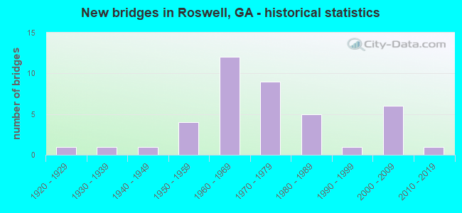
- New bridges - historical statistics
- 11920-1929
- 11930-1939
- 11940-1949
- 41950-1959
- 121960-1969
- 91970-1979
- 51980-1989
- 11990-1999
- 62000-2009
- 12010-2019

- Reconstructed bridges - Historical Statistics
- 11950-1959
- 11960-1969
- 11970-1979
- 51980-1989
- 31990-1999


- Bridge Condition - Deck
- 3.3%Very good
- 63.3%Good
- 26.7%Satisfactory
- 6.7%Fair

- Bridge Condition - Superstructure
- 16.7%Very good
- 60.0%Good
- 16.7%Satisfactory
- 6.7%Fair

- Bridge Condition - Substructure
- 6.7%Very good
- 63.3%Good
- 23.3%Satisfactory
- 6.7%Fair

- Bridge Condition - Channel
- 29.7%Very good
- 54.1%Good
- 8.1%Satisfactory
- 8.1%Fair

- Bridge Condition - Culverts
- 90.9%Good
- 9.1%Satisfactory
Find on map >> Show street view
Structure Number: 1215332, Location: 2 MILES SW OF ALPHARETTA (Lat: 34.061061, Lng: -84.330575), Route carried "on" structure: County highway 9430, Year Built: 2009, Status: Open, Structure Length: 2.90m (9.51ft), Average Daily Traffic: 5,410 (year 2011), Truck Traffic: 1%, Average Future Daily Traffic: 8,115 (year 2031), Design Load: HS 20+Mod, Features Intersected: FOE KILLER CREEK, Facility Carried by Structure: HEMBREE ROAD
Minimum Vertical Clearance: 30+ m (98+ ft), Kilometerpoint: 3.219, Lanes on structure: 2, Base Highway Network: Yes, Owner: City or Municipal Highway Agency, Approaching Roadway Width: 8.5m (27.9ft), Material/Design: Prestressed concrete, Design/Construction: Stringer/Multi-beam, Number Of Spans In Main Unit: 1, Length of Maximum Span: 29.0m (95.1ft), Curb or Sidewalk Widths: Left: 1.8m (5.9ft), Right: 1.8m (5.9ft), Curb-To-Curb Width: 8.5m (27.9ft), Out-to-Out Width: 13.0m (42.7ft)
Condition: Deck: Good, Superstructure: Very good, Substructure: Very good, Channel: Good, Operating Rating: 76.2 metric tons, Method Used To Determine Operating Rating: Load Factor (LF), Inventory Rating: 36.2 metric tons, Method Used To Determine Inventory Rating: Load Factor (LF), Structural Evaluation: Equal to present desirable criteria, Deck Geometry: High priority of replacement, Waterway Adequacy: Equal to present desirable criteria, Approach Roadway Alignment: Equal to present desirable criteria, Designated Inspection Frequency: Every 24 months, Inspection Date: August 2021, Bridge Improvement Cost: $371,000, Roadway Improvement Cost: $37,000, Total Project Cost: $557,000, Deck Structure Type: Concrete Cast-file-Place
Find on map >> Show street view
Structure Number: 1215354, Location: IN SOUTH ROSWELL (Lat: 34.018878, Lng: -84.345153), Route carried "on" structure: City street 3101, Year Built: 2010, Status: Open, Structure Length: 5.36m (17.59ft), Average Daily Traffic: 6,654 (year 2012), Truck Traffic: 2%, Average Future Daily Traffic: 10,287 (year 2031), Design Load: HS 20, Features Intersected: BIG CREEK, Facility Carried by Structure: GRIMES BRIDGE RD A
Minimum Vertical Clearance: 30+ m (98+ ft), Kilometerpoint: 1.609, Lanes on structure: 2, Base Highway Network: Yes, Owner: City or Municipal Highway Agency, Approaching Roadway Width: 8.5m (27.9ft), Skew: 4 degrees, Material/Design: Prestressed concrete, Design/Construction: Stringer/Multi-beam, Number Of Spans In Main Unit: 2, Length of Maximum Span: 26.8m (87.9ft), Curb or Sidewalk Widths: Left: 2.1m (6.9ft), Right: 2.4m (7.9ft), Curb-To-Curb Width: 11.6m (38.1ft), Out-to-Out Width: 17.7m (58.1ft)
Condition: Deck: Good, Superstructure: Very good, Substructure: Good, Channel: Very good, Operating Rating: 89.8 metric tons, Method Used To Determine Operating Rating: Load Factor (LF), Inventory Rating: 48.0 metric tons, Method Used To Determine Inventory Rating: Load Factor (LF), Structural Evaluation: Better than present minimum criteria, Deck Geometry: Somewhat better than minimum adequacy, Waterway Adequacy: Better than present minimum criteria, Approach Roadway Alignment: Equal to present desirable criteria, Designated Inspection Frequency: Every 24 months, Inspection Date: July 2021, Deck Structure Type: Concrete Cast-file-Place
Find on map >> Show street view
Structure Number: 1210086, Location: 8.1 MI N OF I-285 (Lat: 34.021761, Lng: -84.324275), Route carried "under" structure: US 19, Structure Length: 0. m, Average Daily Traffic: 134,600 (year 1999), Truck Traffic: 1%, Features Intersected: SR 140 HOLCOMB BRIDGE RD, Facility Carried by Structure: HOLCOMB BR ROAD
Minimum Vertical Clearance: 5.33m (17.49ft), Kilometerpoint: 24.140, Lanes on structure: 9, Length of Maximum Span: 0.0m
Find on map >> Show street view
Structure Number: 1210125, Location: 1.8 MI E OF ROSWELL (Lat: 34.009850, Lng: -84.332975), Route carried "under" structure: City street 9408, Structure Length: 0. m, Average Daily Traffic: 23,910 (year 2011), Truck Traffic: 1%, Features Intersected: SR 400 (US 19), Facility Carried by Structure: US 19, SR 400
Minimum Vertical Clearance: 10.03m (32.91ft), Kilometerpoint: 0.000, Lanes on structure: 8, Length of Maximum Span: 0.0m