Bridge Statistics for Salina, Kansas (KS)
Condition, Traffic, Stress, Structural Evaluation, Project Costs
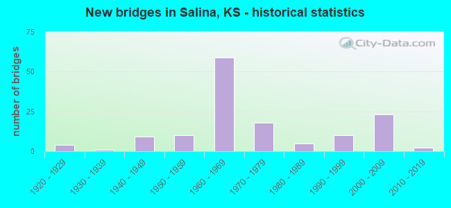
- New bridges - historical statistics
- 41920-1929
- 11930-1939
- 91940-1949
- 101950-1959
- 591960-1969
- 181970-1979
- 51980-1989
- 101990-1999
- 232000-2009
- 22010-2019
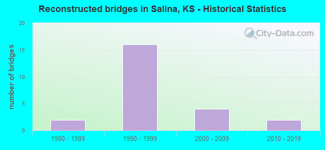
- Reconstructed bridges - Historical Statistics
- 21980-1989
- 161990-1999
- 42000-2009
- 22010-2019
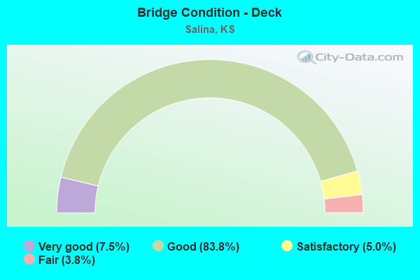
- Bridge Condition - Deck
- 7.5%Very good
- 83.8%Good
- 5.0%Satisfactory
- 3.8%Fair
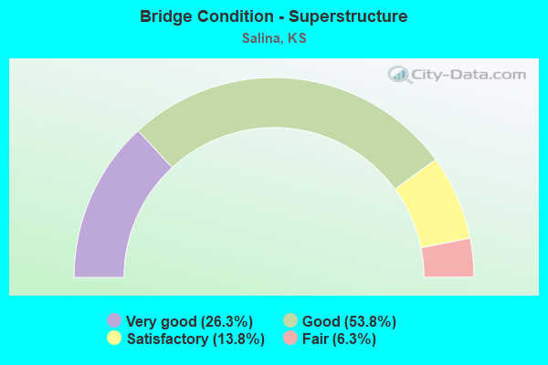
- Bridge Condition - Superstructure
- 26.3%Very good
- 53.8%Good
- 13.8%Satisfactory
- 6.3%Fair
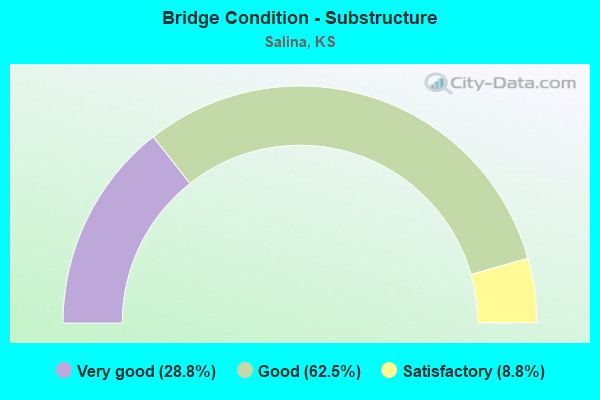
- Bridge Condition - Substructure
- 28.8%Very good
- 62.5%Good
- 8.8%Satisfactory
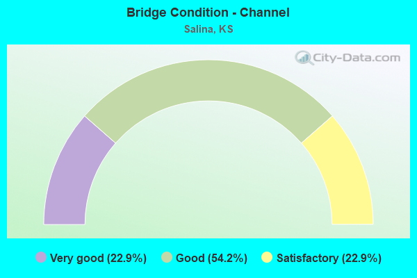
- Bridge Condition - Channel
- 22.9%Very good
- 54.2%Good
- 22.9%Satisfactory
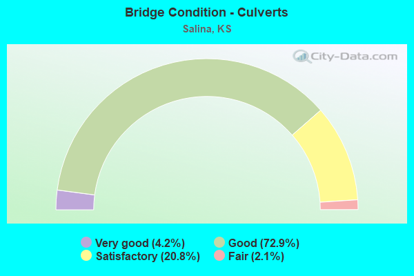
- Bridge Condition - Culverts
- 4.2%Very good
- 72.9%Good
- 20.8%Satisfactory
- 2.1%Fair
Find on map >> Show street view
Structure Number: 850795504522, Location: 3.0N 2.0E OF SALINA (Lat: 38.899233, Lng: -97.566167), Route carried "on" structure: County highway 8532, Year Built: 1948, Status: Open, Structure Length: 0.85m (2.79ft), Average Daily Traffic: 197 (year 2019), Truck Traffic: 6%, Average Future Daily Traffic: 240 (year 2043), Features Intersected: LOCAL DRAINAGE, Facility Carried by Structure: MINOR 795.5-452.2
Minimum Vertical Clearance: 30.47m (99.97ft), Kilometerpoint: 5.953, Lanes on structure: 2, Owner: County Highway Agency, Approaching Roadway Width: 6.1m (20.0ft), Material/Design: Concrete continuous, Design/Construction: Slab, Number Of Spans In Main Unit: 2, Length of Maximum Span: 3.7m (12.1ft), Curb-To-Curb Width: 8.4m (27.6ft), Out-to-Out Width: 8.8m (28.9ft)
Condition: Deck: Good, Superstructure: Good, Substructure: Good, Channel: Good, Operating Rating: 20.4 metric tons, Method Used To Determine Operating Rating: Allowable Stress (AS), Inventory Rating: 16.3 metric tons, Method Used To Determine Inventory Rating: Allowable Stress (AS), Structural Evaluation: Somewhat better than minimum adequacy, Deck Geometry: Somewhat better than minimum adequacy, Waterway Adequacy: Equal to present minimum criteria, Approach Roadway Alignment: Equal to present desirable criteria, Length Of Structure Improvement: 0.91m (2.99ft), Designated Inspection Frequency: Every 24 months, Inspection Date: Febuary 2021, Bridge Improvement Cost: $100,000, Roadway Improvement Cost: $25,000, Total Project Cost: $150,000, Deck Structure Type: Concrete Cast-file-Place, Wearing Surface/Protective System: Wearing Surface: Gravel
Find on map >> Show street view
Structure Number: 850797004602, Location: 0.2S 3.0E OF SALINA (Lat: 38.838639, Lng: -97.557511), Route carried "on" structure: County highway 8513, Year Built: 1960, Status: Posted for load, Structure Length: 0.76m (2.49ft), Average Daily Traffic: 414 (year 2017), Truck Traffic: 6%, Average Future Daily Traffic: 505 (year 2043), Features Intersected: WATERWAY, Facility Carried by Structure: MINOR 797-460.2
Minimum Vertical Clearance: 30.47m (99.97ft), Kilometerpoint: 0.000, Lanes on structure: 2, Owner: County Highway Agency, Approaching Roadway Width: 7.3m (24.0ft), Material/Design: Concrete, Design/Construction: Culvert, Number Of Spans In Main Unit: 3, Length of Maximum Span: 2.4m (7.9ft), Curb-To-Curb Width: 7.3m (24.0ft), Out-to-Out Width: 7.9m (25.9ft)
Condition: Channel: Good, Culverts: Good, Operating Rating: 13.5 metric tons, Method Used To Determine Operating Rating: Allowable Stress (AS), Inventory Rating: 9.9 metric tons, Method Used To Determine Inventory Rating: Allowable Stress (AS), Structural Evaluation: High priority of replacement, Deck Geometry: Meets minimum limits, Waterway Adequacy: Equal to present minimum criteria, Approach Roadway Alignment: Equal to present desirable criteria, Bridge Posting: Required (Relationship of Operating Rating to Maximum Legal Load: 30.0 - 39.9% below), Length Of Structure Improvement: 0.76m (2.49ft), Designated Inspection Frequency: Every 24 months, Inspection Date: Febuary 2021, Bridge Improvement Cost: $32,000, Roadway Improvement Cost: $3,000, Total Project Cost: $48,000
Find on map >> Show street view
Structure Number: 425400854802001, Location: 0.4 W OF I-135 (Lat: 38.783639, Lng: -97.624942), Route carried "on" structure: City street 4802, Year Built: 1955, Status: Posted for load, Structure Length: 0.69m (2.26ft), Average Daily Traffic: 5,705 (year 2014), Truck Traffic: 10%, Average Future Daily Traffic: 7,200 (year 2043), Design Load: H 20, Features Intersected: DRAINAGE CHANNEL, Facility Carried by Structure: SCHILLING ROAD
Minimum Vertical Clearance: 30.47m (99.97ft), Kilometerpoint: 0.000, Lanes on structure: 2, Owner: City or Municipal Highway Agency, Approaching Roadway Width: 6.7m (22.0ft), Material/Design: Concrete, Design/Construction: Culvert, Number Of Spans In Main Unit: 2, Length of Maximum Span: 3.0m (9.8ft)
Condition: Channel: Very good, Culverts: Good, Operating Rating: 21.8 metric tons, Method Used To Determine Operating Rating: Field evaluation and documented engineering judgment, Inventory Rating: 21.8 metric tons, Method Used To Determine Inventory Rating: Field evaluation and documented engineering judgment, Structural Evaluation: Somewhat better than minimum adequacy, Waterway Adequacy: Equal to present desirable criteria, Approach Roadway Alignment: Equal to present desirable criteria, Bridge Posting: Required (Relationship of Operating Rating to Maximum Legal Load: > 39.9% below), Designated Inspection Frequency: Every 24 months, Inspection Date: November 2021
Find on map >> Show street view
Structure Number: 425400854802002, Location: 0.25W OF I-135 (Lat: 38.783619, Lng: -97.621883), Route carried "on" structure: City street 4802, Year Built: 2000, Status: Open, Structure Length: 1.66m (5.45ft), Average Daily Traffic: 8,100 (year 2014), Truck Traffic: 10%, Average Future Daily Traffic: 10,200 (year 2043), Design Load: HS 20, Features Intersected: DRY CREEK, Facility Carried by Structure: SCHILLING ROAD
Minimum Vertical Clearance: 30.47m (99.97ft), Kilometerpoint: 0.000, Lanes on structure: 4, Owner: City or Municipal Highway Agency, Approaching Roadway Width: 14.5m (47.6ft), Skew: 4 degrees, Material/Design: Concrete, Design/Construction: Culvert, Number Of Spans In Main Unit: 2, Length of Maximum Span: 5.5m (18.0ft)
Condition: Channel: Good, Culverts: Good, Operating Rating: 90.5 metric tons, Method Used To Determine Operating Rating: Load Factor (LF), Inventory Rating: 69.6 metric tons, Method Used To Determine Inventory Rating: Load Factor (LF), Structural Evaluation: Better than present minimum criteria, Waterway Adequacy: Equal to present desirable criteria, Approach Roadway Alignment: Equal to present desirable criteria, Designated Inspection Frequency: Every 24 months, Inspection Date: November 2021
Find on map >> Show street view
Structure Number: 425400854802003, Location: 0.8W OF I-135 (Lat: 38.783675, Lng: -97.631497), Route carried "on" structure: City street 4802, Year Built: 1940, Year Reconstructed: 1999, Status: Open, Structure Length: 0.85m (2.79ft), Average Daily Traffic: 5,705 (year 2014), Truck Traffic: 10%, Average Future Daily Traffic: 7,200 (year 2043), Features Intersected: DRAINAGE CHANNEL, Facility Carried by Structure: SCHILLING ROAD
Minimum Vertical Clearance: 7.62m (25.00ft), Kilometerpoint: 0.000, Lanes on structure: 2, Owner: City or Municipal Highway Agency, Approaching Roadway Width: 11.8m (38.7ft), Material/Design: Concrete, Design/Construction: Culvert, Number Of Spans In Main Unit: 4, Length of Maximum Span: 1.8m (5.9ft)
Condition: Channel: Good, Culverts: Satisfactory, Operating Rating: 32.7 metric tons, Method Used To Determine Operating Rating: Field evaluation and documented engineering judgment, Inventory Rating: 32.7 metric tons, Method Used To Determine Inventory Rating: Field evaluation and documented engineering judgment, Structural Evaluation: Equal to present minimum criteria, Waterway Adequacy: Equal to present minimum criteria, Approach Roadway Alignment: Equal to present desirable criteria, Designated Inspection Frequency: Every 24 months, Inspection Date: November 2021
Find on map >> Show street view
Structure Number: 425400854803001, Location: 4.8 S OF I-70 (Lat: 38.804992, Lng: -97.634356), Route carried "on" structure: City street 4803, Year Built: 1955, Year Reconstructed: 1999, Status: Open, Structure Length: 1.04m (3.41ft), Average Daily Traffic: 8,200 (year 2014), Truck Traffic: 15%, Average Future Daily Traffic: 8,400 (year 2043), Features Intersected: DRAINAGE CHANNEL, Facility Carried by Structure: CENTENNIAL ROAD
Minimum Vertical Clearance: 30.47m (99.97ft), Kilometerpoint: 0.000, Lanes on structure: 4, Owner: City or Municipal Highway Agency, Approaching Roadway Width: 16.1m (52.8ft), Material/Design: Concrete, Design/Construction: Culvert, Number Of Spans In Main Unit: 4, Length of Maximum Span: 2.4m (7.9ft)
Condition: Channel: Satisfactory, Culverts: Good, Operating Rating: 54.4 metric tons, Method Used To Determine Operating Rating: Field evaluation and documented engineering judgment, Inventory Rating: 32.7 metric tons, Method Used To Determine Inventory Rating: Field evaluation and documented engineering judgment, Structural Evaluation: Better than present minimum criteria, Waterway Adequacy: Equal to present minimum criteria, Approach Roadway Alignment: Equal to present desirable criteria, Designated Inspection Frequency: Every 24 months, Inspection Date: August 2021
Find on map >> Show street view
Structure Number: 425400854803002, Location: 6.8 mi S/O I-70 (Lat: 38.777219, Lng: -97.631700), Route carried "on" structure: City street 4803, Year Built: 1940, Year Reconstructed: 2016, Status: Open, Structure Length: 0.69m (2.26ft), Average Daily Traffic: 1,910 (year 2014), Truck Traffic: 15%, Average Future Daily Traffic: 2,000 (year 2043), Design Load: HL 93, Features Intersected: DRAINAGE CHANNEL, Facility Carried by Structure: CENTENNIAL ROAD
Minimum Vertical Clearance: 6.24m (20.47ft), Kilometerpoint: 0.000, Lanes on structure: 2, Owner: City or Municipal Highway Agency, Approaching Roadway Width: 9.7m (31.8ft), Skew: 4 degrees, Material/Design: Concrete, Design/Construction: Culvert, Number Of Spans In Main Unit: 3, Length of Maximum Span: 2.2m (7.2ft), Curb-To-Curb Width: 9.8m (32.2ft), Out-to-Out Width: 9.8m (32.2ft)
Condition: Channel: Good, Culverts: Very good, Operating Rating: 39.7 metric tons, Method Used To Determine Operating Rating: Load and Resistance Factor (LRFR), Inventory Rating: 30.7 metric tons, Method Used To Determine Inventory Rating: Load and Resistance Factor (LRFR), Structural Evaluation: Better than present minimum criteria, Deck Geometry: Somewhat better than minimum adequacy, Waterway Adequacy: Better than present minimum criteria, Approach Roadway Alignment: Equal to present desirable criteria, Designated Inspection Frequency: Every 24 months, Inspection Date: August 2021
Find on map >> Show street view
Structure Number: 425400854807893, Location: 2.1 S OF I-70 (Lat: 38.845194, Lng: -97.624817), Route carried "on" structure: City street 4807, Year Built: 1990, Status: Open, Structure Length: 13.81m (45.31ft), Average Daily Traffic: 7,730 (year 2014), Truck Traffic: 5%, Average Future Daily Traffic: 13,100 (year 2043), Design Load: HS 20, Features Intersected: UPRR TRACKS, Facility Carried by Structure: BROADWAY BLVD
Minimum Vertical Clearance: 30.47m (99.97ft), Kilometerpoint: 0.000, Lanes on structure: 4, Lanes under structure: 2, Owner: City or Municipal Highway Agency, Approaching Roadway Width: 14.5m (47.6ft), Skew: 2 degrees, Material/Design: Steel continuous, Design/Construction: Stringer/Multi-beam, Number Of Spans In Main Unit: 7, Length of Maximum Span: 22.9m (75.1ft), Curb or Sidewalk Widths: Left: 0.0m, Right: 1.5m (4.9ft), Curb-To-Curb Width: 14.6m (47.9ft), Out-to-Out Width: 17.3m (56.8ft)
Condition: Deck: Good, Superstructure: Good, Substructure: Satisfactory, Operating Rating: 39.2 metric tons, Method Used To Determine Operating Rating: Load Factor (LF), Inventory Rating: 23.4 metric tons, Method Used To Determine Inventory Rating: Load Factor (LF), Structural Evaluation: Somewhat better than minimum adequacy, Deck Geometry: High priority of replacement, Underclear: Meets minimum limits, Approach Roadway Alignment: Equal to present desirable criteria, Designated Inspection Frequency: Every 24 months, Inspection Date: November 2021, Deck Structure Type: Concrete Cast-file-Place, Wearing Surface/Protective System: Wearing Surface: Low Slump Concrete, Deck Protection: Epoxy Coated Reinforcing
Find on map >> Show street view
Structure Number: 425400854810891, Location: 0.1 E OF I-135 (Lat: 38.812661, Lng: -97.630900), Route carried "on" structure: City street 4810, Year Built: 2000, Status: Open, Structure Length: 1.18m (3.87ft), Average Daily Traffic: 3,800 (year 2014), Truck Traffic: 10%, Average Future Daily Traffic: 3,900 (year 2043), Design Load: HS 20, Features Intersected: DRY CREEK, Facility Carried by Structure: CLOUD STREET
Minimum Vertical Clearance: 30.47m (99.97ft), Kilometerpoint: 0.000, Lanes on structure: 2, Owner: City or Municipal Highway Agency, Approaching Roadway Width: 9.5m (31.2ft), Material/Design: Concrete, Design/Construction: Culvert, Number Of Spans In Main Unit: 2, Length of Maximum Span: 5.5m (18.0ft), Curb or Sidewalk Widths: Left: 0.0m, Right: 3.4m (11.2ft), Curb-To-Curb Width: 10.7m (35.1ft), Out-to-Out Width: 14.9m (48.9ft)
Condition: Channel: Very good, Culverts: Good, Operating Rating: 88.6 metric tons, Method Used To Determine Operating Rating: Load Factor (LF), Inventory Rating: 53.1 metric tons, Method Used To Determine Inventory Rating: Load Factor (LF), Structural Evaluation: Better than present minimum criteria, Deck Geometry: Somewhat better than minimum adequacy, Waterway Adequacy: Equal to present desirable criteria, Approach Roadway Alignment: Better than present minimum criteria, Designated Inspection Frequency: Every 24 months, Inspection Date: August 2021
Find on map >> Show street view
Structure Number: 425400854816001, Location: 0.4E OF OHIO ST. (Lat: 38.827031, Lng: -97.585717), Route carried "on" structure: City street 4816, Year Built: 1981, Status: Open, Structure Length: 10.02m (32.87ft), Average Daily Traffic: 12,940 (year 2014), Truck Traffic: 5%, Average Future Daily Traffic: 22,400 (year 2043), Design Load: HS 20, Features Intersected: SMOKY HILL RIVER, Facility Carried by Structure: CRAWFORD STREET
Minimum Vertical Clearance: 30.47m (99.97ft), Kilometerpoint: 0.000, Lanes on structure: 4, Owner: City or Municipal Highway Agency, Approaching Roadway Width: 16.1m (52.8ft), Material/Design: Steel continuous, Design/Construction: Stringer/Multi-beam, Number Of Spans In Main Unit: 3, Length of Maximum Span: 38.1m (125.0ft), Curb or Sidewalk Widths: Left: 1.6m (5.2ft), Right: 0.0m, Curb-To-Curb Width: 16.2m (53.1ft), Out-to-Out Width: 18.4m (60.4ft)
Condition: Deck: Good, Superstructure: Good, Substructure: Good, Channel: Satisfactory, Operating Rating: 37.4 metric tons, Method Used To Determine Operating Rating: Load Factor (LF), Inventory Rating: 22.4 metric tons, Method Used To Determine Inventory Rating: Load Factor (LF), Structural Evaluation: Somewhat better than minimum adequacy, Deck Geometry: Meets minimum limits, Waterway Adequacy: Better than present minimum criteria, Approach Roadway Alignment: Equal to present desirable criteria, Designated Inspection Frequency: Every 24 months, Inspection Date: November 2021, Deck Structure Type: Concrete Cast-file-Place
Find on map >> Show street view
Structure Number: 425400854816002, Location: 0.25E OF I-135 (Lat: 38.827169, Lng: -97.637106), Route carried "on" structure: City street 4816, Year Built: 1960, Status: Posted for load, Structure Length: 1.18m (3.87ft), Average Daily Traffic: 12,960 (year 2014), Truck Traffic: 15%, Average Future Daily Traffic: 15,500 (year 2043), Design Load: H 20, Features Intersected: DRY CREEK, Facility Carried by Structure: CRAWFORD STREET
Minimum Vertical Clearance: 30.47m (99.97ft), Kilometerpoint: 0.000, Lanes on structure: 4, Owner: City or Municipal Highway Agency, Approaching Roadway Width: 15.7m (51.5ft), Material/Design: Concrete, Design/Construction: Culvert, Number Of Spans In Main Unit: 2, Length of Maximum Span: 5.5m (18.0ft), Curb or Sidewalk Widths: Left: 1.5m (4.9ft), Right: 0.0m, Curb-To-Curb Width: 16.0m (52.5ft), Out-to-Out Width: 22.9m (75.1ft)
Condition: Channel: Satisfactory, Culverts: Satisfactory, Operating Rating: 37.4 metric tons, Method Used To Determine Operating Rating: Load Factor (LF), Inventory Rating: 22.3 metric tons, Method Used To Determine Inventory Rating: Load Factor (LF), Structural Evaluation: Somewhat better than minimum adequacy, Deck Geometry: Meets minimum limits, Waterway Adequacy: Equal to present desirable criteria, Approach Roadway Alignment: Better than present minimum criteria, Bridge Posting: Required (Relationship of Operating Rating to Maximum Legal Load: 10.0 - 19.9% below), Designated Inspection Frequency: Every 24 months, Inspection Date: August 2021, Roadway Improvement Cost: $16,000, Total Project Cost: $19,000
Find on map >> Show street view
Structure Number: 42540085481791, Location: 0.25 S OF I-70 (Lat: 38.873672, Lng: -97.612389), Route carried "on" structure: City street 791, Year Built: 2004, Status: Open, Structure Length: 7.11m (23.33ft), Average Daily Traffic: 3,850 (year 2014), Truck Traffic: 15%, Average Future Daily Traffic: 4,800 (year 2043), Design Load: HS 20, Features Intersected: MULBERRY CREEK, Facility Carried by Structure: SB NINTH STREET
Minimum Vertical Clearance: 30.47m (99.97ft), Kilometerpoint: 0.000, Lanes on structure: 2, Owner: City or Municipal Highway Agency, Approaching Roadway Width: 10.3m (33.8ft), Skew: 20 degrees, Material/Design: Concrete continuous, Design/Construction: Slab, Number Of Spans In Main Unit: 6, Length of Maximum Span: 13.0m (42.7ft), Curb-To-Curb Width: 10.7m (35.1ft), Out-to-Out Width: 14.7m (48.2ft)
Condition: Deck: Good, Superstructure: Good, Substructure: Very good, Channel: Satisfactory, Operating Rating: 93.5 metric tons, Method Used To Determine Operating Rating: Load Factor (LF), Inventory Rating: 56.0 metric tons, Method Used To Determine Inventory Rating: Load Factor (LF), Structural Evaluation: Better than present minimum criteria, Deck Geometry: Somewhat better than minimum adequacy, Waterway Adequacy: Better than present minimum criteria, Approach Roadway Alignment: Equal to present desirable criteria, Designated Inspection Frequency: Every 24 months, Inspection Date: November 2021, Deck Structure Type: Concrete Cast-file-Place, Wearing Surface/Protective System: Wearing Surface: Low Slump Concrete, Deck Protection: Epoxy Coated Reinforcing
Find on map >> Show street view
Structure Number: 425400854832001, Location: 3.4 E OF I-135 (Lat: 38.840381, Lng: -97.582233), Route carried "on" structure: City street 4832, Year Built: 1960, Year Reconstructed: 1986, Status: Open, Structure Length: 8.72m (28.61ft), Average Daily Traffic: 6,800 (year 2014), Truck Traffic: 1%, Average Future Daily Traffic: 8,300 (year 2043), Design Load: HS 20, Features Intersected: SMOKY HILL RIVER, Facility Carried by Structure: IRON AVENUE
Minimum Vertical Clearance: 9.14m (29.99ft), Kilometerpoint: 0.000, Lanes on structure: 2, Owner: City or Municipal Highway Agency, Approaching Roadway Width: 13.4m (44.0ft), Skew: 4 degrees, Material/Design: Steel continuous, Design/Construction: Stringer/Multi-beam, Number Of Spans In Main Unit: 3, Length of Maximum Span: 33.5m (109.9ft), Curb or Sidewalk Widths: Left: 1.4m (4.6ft), Right: 1.4m (4.6ft), Curb-To-Curb Width: 15.0m (49.2ft), Out-to-Out Width: 18.6m (61.0ft)
Condition: Deck: Good, Superstructure: Good, Substructure: Satisfactory, Channel: Very good, Operating Rating: 75.6 metric tons, Method Used To Determine Operating Rating: Load Factor (LF), Inventory Rating: 45.2 metric tons, Method Used To Determine Inventory Rating: Load Factor (LF), Structural Evaluation: Equal to present minimum criteria, Deck Geometry: Superior to present desirable criteria, Waterway Adequacy: Equal to present desirable criteria, Approach Roadway Alignment: Equal to present desirable criteria, Designated Inspection Frequency: Every 24 months, Inspection Date: November 2021, Deck Structure Type: Concrete Cast-file-Place, Wearing Surface/Protective System: Wearing Surface: Monolithic Concrete, Deck Protection: Epoxy Coated Reinforcing
Find on map >> Show street view
Structure Number: 425400854833914, Location: 3.0 S OF I-70 (Lat: 38.835994, Lng: -97.600781), Route carried "on" structure: City street 4833, Year Built: 1960, Year Reconstructed: 1992, Status: Open, Structure Length: 4.19m (13.75ft), Average Daily Traffic: 3,680 (year 2014), Truck Traffic: 1%, Average Future Daily Traffic: 4,600 (year 2043), Design Load: HS 20, Features Intersected: OLD SMOKY HILL RIVER CHN, Facility Carried by Structure: OAKDALE AVE.
Minimum Vertical Clearance: 30.47m (99.97ft), Kilometerpoint: 0.000, Lanes on structure: 2, Owner: City or Municipal Highway Agency, Approaching Roadway Width: 13.4m (44.0ft), Skew: 3 degrees, Material/Design: Concrete continuous, Design/Construction: Slab, Number Of Spans In Main Unit: 5, Length of Maximum Span: 9.1m (29.9ft), Curb or Sidewalk Widths: Left: 1.8m (5.9ft), Right: 1.8m (5.9ft), Curb-To-Curb Width: 13.4m (44.0ft), Out-to-Out Width: 17.6m (57.7ft)
Condition: Deck: Good, Superstructure: Good, Substructure: Good, Channel: Good, Operating Rating: 59.2 metric tons, Method Used To Determine Operating Rating: Load Factor (LF), Inventory Rating: 35.5 metric tons, Method Used To Determine Inventory Rating: Load Factor (LF), Structural Evaluation: Better than present minimum criteria, Deck Geometry: Better than present minimum criteria, Waterway Adequacy: Equal to present desirable criteria, Approach Roadway Alignment: Equal to present minimum criteria, Designated Inspection Frequency: Every 24 months, Inspection Date: November 2021, Deck Structure Type: Concrete Cast-file-Place, Wearing Surface/Protective System: Wearing Surface: Monolithic Concrete, Deck Protection: Epoxy Coated Reinforcing
Find on map >> Show street view
Structure Number: 425400854836002, Location: 0.9 E OF I-135 (Lat: 38.841653, Lng: -97.630483), Route carried "on" structure: City street 4836, Year Built: 1959, Status: Posted for load, Structure Length: 1.19m (3.90ft), Average Daily Traffic: 2,940 (year 2014), Truck Traffic: 5%, Average Future Daily Traffic: 3,700 (year 2043), Design Load: H 20, Features Intersected: DRY CREEK, Facility Carried by Structure: STATE STREET
Minimum Vertical Clearance: 30.47m (99.97ft), Kilometerpoint: 0.000, Lanes on structure: 2, Owner: City or Municipal Highway Agency, Approaching Roadway Width: 9.8m (32.2ft), Material/Design: Concrete, Design/Construction: Culvert, Number Of Spans In Main Unit: 2, Length of Maximum Span: 5.5m (18.0ft), Curb-To-Curb Width: 10.0m (32.8ft), Out-to-Out Width: 10.4m (34.1ft)
Condition: Channel: Satisfactory, Culverts: Satisfactory, Operating Rating: 42.3 metric tons, Method Used To Determine Operating Rating: Load Factor (LF), Inventory Rating: 25.3 metric tons, Method Used To Determine Inventory Rating: Load Factor (LF), Structural Evaluation: Equal to present minimum criteria, Deck Geometry: Meets minimum limits, Waterway Adequacy: Better than present minimum criteria, Approach Roadway Alignment: Equal to present desirable criteria, Designated Inspection Frequency: Every 24 months, Inspection Date: August 2021, Bridge Improvement Cost: $20,000, Roadway Improvement Cost: $9,000, Total Project Cost: $34,000
Find on map >> Show street view
Structure Number: 525400850000001, Location: 4.8 S OF I-70 (Lat: 38.805025, Lng: -97.636433), Route carried "on" structure: City street , Year Built: 1955, Status: Posted for load, Structure Length: 0.98m (3.22ft), Average Daily Traffic: 300 (year 2015), Truck Traffic: 5%, Average Future Daily Traffic: 400 (year 2043), Features Intersected: DRAINAGE CHANNEL, Facility Carried by Structure: SCANLAN AVE.
Minimum Vertical Clearance: 30.47m (99.97ft), Kilometerpoint: 0.000, Lanes on structure: 2, Owner: City or Municipal Highway Agency, Approaching Roadway Width: 6.7m (22.0ft), Material/Design: Concrete, Design/Construction: Culvert, Number Of Spans In Main Unit: 4, Length of Maximum Span: 2.3m (7.5ft)
Condition: Channel: Satisfactory, Culverts: Satisfactory, Operating Rating: 18.1 metric tons, Method Used To Determine Operating Rating: Field evaluation and documented engineering judgment, Inventory Rating: 18.1 metric tons, Method Used To Determine Inventory Rating: Field evaluation and documented engineering judgment, Structural Evaluation: Somewhat better than minimum adequacy, Waterway Adequacy: Equal to present minimum criteria, Approach Roadway Alignment: Equal to present desirable criteria, Bridge Posting: Required (Relationship of Operating Rating to Maximum Legal Load: > 39.9% below), Designated Inspection Frequency: Every 24 months, Inspection Date: August 2021
Find on map >> Show street view
Structure Number: 525400850000004, Location: 2.1 E OF I-135 (Lat: 38.835692, Lng: -97.604211), Route carried "on" structure: City street , Year Built: 1997, Status: Open, Structure Length: 3.73m (12.24ft), Average Daily Traffic: 681 (year 2017), Truck Traffic: 1%, Average Future Daily Traffic: 800 (year 2043), Design Load: HS 20, Features Intersected: OLD SMOKY HILL RIVER, Facility Carried by Structure: MULBERRY STREET
Minimum Vertical Clearance: 30.47m (99.97ft), Kilometerpoint: 0.000, Lanes on structure: 2, Owner: City or Municipal Highway Agency, Approaching Roadway Width: 10.3m (33.8ft), Material/Design: Concrete continuous, Design/Construction: Slab, Number Of Spans In Main Unit: 3, Length of Maximum Span: 14.6m (47.9ft), Curb or Sidewalk Widths: Left: 1.8m (5.9ft), Right: 1.8m (5.9ft), Curb-To-Curb Width: 9.1m (29.9ft), Out-to-Out Width: 13.3m (43.6ft)
Condition: Deck: Good, Superstructure: Very good, Substructure: Good, Channel: Very good, Operating Rating: 73.5 metric tons, Method Used To Determine Operating Rating: Load Factor (LF), Inventory Rating: 43.9 metric tons, Method Used To Determine Inventory Rating: Load Factor (LF), Structural Evaluation: Better than present minimum criteria, Deck Geometry: Equal to present minimum criteria, Waterway Adequacy: Equal to present desirable criteria, Approach Roadway Alignment: Equal to present minimum criteria, Designated Inspection Frequency: Every 24 months, Inspection Date: November 2021, Deck Structure Type: Concrete Cast-file-Place, Wearing Surface/Protective System: Wearing Surface: Monolithic Concrete, Deck Protection: Epoxy Coated Reinforcing
Find on map >> Show street view
Structure Number: 525400850000006, Location: 2.3 E OF I-135 (Lat: 38.838319, Lng: -97.603194), Route carried "on" structure: City street , Year Built: 1999, Status: Open, Structure Length: 2.70m (8.86ft), Average Daily Traffic: 1,435 (year 2017), Truck Traffic: 5%, Average Future Daily Traffic: 1,800 (year 2043), Design Load: HS 20, Features Intersected: OLD SMOKY HILL RIVER, Facility Carried by Structure: WALNUT STREET
Minimum Vertical Clearance: 30.47m (99.97ft), Kilometerpoint: 0.000, Lanes on structure: 2, Owner: City or Municipal Highway Agency, Approaching Roadway Width: 8.5m (27.9ft), Material/Design: Prestressed concrete, Design/Construction: Stringer/Multi-beam, Number Of Spans In Main Unit: 1, Length of Maximum Span: 26.2m (86.0ft), Curb or Sidewalk Widths: Left: 1.8m (5.9ft), Right: 1.8m (5.9ft), Curb-To-Curb Width: 8.6m (28.2ft), Out-to-Out Width: 12.8m (42.0ft)
Condition: Deck: Good, Superstructure: Very good, Substructure: Good, Channel: Very good, Operating Rating: 96.0 metric tons, Method Used To Determine Operating Rating: Load Factor (LF), Inventory Rating: 42.5 metric tons, Method Used To Determine Inventory Rating: Load Factor (LF), Structural Evaluation: Better than present minimum criteria, Deck Geometry: Somewhat better than minimum adequacy, Waterway Adequacy: Equal to present desirable criteria, Approach Roadway Alignment: Meets minimum limits, Designated Inspection Frequency: Every 24 months, Inspection Date: November 2021, Deck Structure Type: Concrete Cast-file-Place, Wearing Surface/Protective System: Wearing Surface: Monolithic Concrete, Deck Protection: Epoxy Coated Reinforcing
Find on map >> Show street view
Structure Number: 525400850000009, Location: 3MI. S. OF I-70 (Lat: 38.854783, Lng: -97.593889), Route carried "on" structure: City street , Year Built: 2006, Status: Open, Structure Length: 16.17m (53.05ft), Average Daily Traffic: 9,115 (year 2014), Truck Traffic: 5%, Average Future Daily Traffic: 18,100 (year 2043), Design Load: HS 20, Features Intersected: UPRR TRACKS, Facility Carried by Structure: N. OHIO ST.
Minimum Vertical Clearance: 30.47m (99.97ft), Kilometerpoint: 0.000, Lanes on structure: 4, Owner: City or Municipal Highway Agency, Approaching Roadway Width: 15.8m (51.8ft), Skew: 2 degrees, Material/Design: Prestressed concrete continuous, Design/Construction: Stringer/Multi-beam, Number Of Spans In Main Unit: 6, Length of Maximum Span: 38.7m (127.0ft), Curb or Sidewalk Widths: Left: 3.0m (9.8ft), Right: 0.0m, Curb-To-Curb Width: 15.8m (51.8ft), Out-to-Out Width: 19.9m (65.3ft)
Condition: Deck: Good, Superstructure: Very good, Substructure: Satisfactory, Operating Rating: 53.6 metric tons, Method Used To Determine Operating Rating: Load Factor (LF), Inventory Rating: 32.1 metric tons, Method Used To Determine Inventory Rating: Load Factor (LF), Structural Evaluation: Equal to present minimum criteria, Deck Geometry: Meets minimum limits, Underclear: Equal to present minimum criteria, Approach Roadway Alignment: Equal to present desirable criteria, Designated Inspection Frequency: Every 24 months, Inspection Date: November 2021, Deck Structure Type: Concrete Cast-file-Place, Wearing Surface/Protective System: Wearing Surface: Latex Concrete, Deck Protection: Epoxy Coated Reinforcing
Find on map >> Show street view
Structure Number: 52540085000002, Location: 0.6 E OF I-135 (Lat: 38.798097, Lng: -97.607517), Route carried "on" structure: City street , Year Built: 1961, Status: Posted for load, Structure Length: 0.76m (2.49ft), Average Daily Traffic: 17,150 (year 2014), Truck Traffic: 5%, Average Future Daily Traffic: 28,300 (year 2043), Design Load: H 20, Features Intersected: CENTRAL MALL DRAINAGE, Facility Carried by Structure: MAGNOLIA RD.
Minimum Vertical Clearance: 30.47m (99.97ft), Kilometerpoint: 0.000, Lanes on structure: 4, Owner: City or Municipal Highway Agency, Approaching Roadway Width: 12.1m (39.7ft), Skew: 6 degrees, Material/Design: Concrete, Design/Construction: Culvert, Number Of Spans In Main Unit: 2, Length of Maximum Span: 3.7m (12.1ft)
Condition: Channel: Good, Culverts: Satisfactory, Operating Rating: 27.1 metric tons, Method Used To Determine Operating Rating: Load Factor (LF), Inventory Rating: 16.1 metric tons, Method Used To Determine Inventory Rating: Load Factor (LF), Structural Evaluation: High priority of corrective action, Waterway Adequacy: Equal to present desirable criteria, Approach Roadway Alignment: Equal to present desirable criteria, Bridge Posting: Required (Relationship of Operating Rating to Maximum Legal Load: 20.0 - 29.9% below), Designated Inspection Frequency: Every 24 months, Inspection Date: November 2021
Find on map >> Show street view
Structure Number: 525400850000021, Location: 4.2 S OF I-70 (Lat: 38.814186, Lng: -97.632583), Route carried "on" structure: City street , Year Built: 1958, Year Reconstructed: 1999, Status: Open, Structure Length: 1.18m (3.87ft), Average Daily Traffic: 8,640 (year 2014), Truck Traffic: 5%, Average Future Daily Traffic: 12,900 (year 2043), Design Load: H 20, Features Intersected: DRY CREEK, Facility Carried by Structure: CENTENNIAL ROAD
Minimum Vertical Clearance: 30.47m (99.97ft), Kilometerpoint: 0.000, Lanes on structure: 2, Owner: City or Municipal Highway Agency, Approaching Roadway Width: 12.8m (42.0ft), Material/Design: Concrete, Design/Construction: Culvert, Number Of Spans In Main Unit: 2, Length of Maximum Span: 5.5m (18.0ft), Curb-To-Curb Width: 9.3m (30.5ft), Out-to-Out Width: 12.8m (42.0ft)
Condition: Channel: Good, Culverts: Good, Operating Rating: 49.9 metric tons, Method Used To Determine Operating Rating: Load Factor (LF), Inventory Rating: 29.8 metric tons, Method Used To Determine Inventory Rating: Load Factor (LF), Structural Evaluation: Better than present minimum criteria, Deck Geometry: High priority of corrective action, Waterway Adequacy: Equal to present desirable criteria, Approach Roadway Alignment: Equal to present desirable criteria, Designated Inspection Frequency: Every 24 months, Inspection Date: August 2021
Find on map >> Show street view
Structure Number: 525400850000918, Location: KENWOOD PARK IN SALINA (Lat: 38.834272, Lng: -97.597086), Route carried "on" structure: City street 2089, Year Built: 2015, Status: Open, Structure Length: 1.31m (4.30ft), Average Daily Traffic: 1,530 (year 2011), Truck Traffic: 2%, Average Future Daily Traffic: 2,000 (year 2043), Design Load: HL 93, Features Intersected: OLD SMOKY HILL RIVER, Facility Carried by Structure: GREELEY AVENUE
Minimum Vertical Clearance: 30.47m (99.97ft), Kilometerpoint: 0.000, Lanes on structure: 2, Owner: City or Municipal Highway Agency, Approaching Roadway Width: 9.4m (30.8ft), Material/Design: Concrete, Number Of Spans In Main Unit: 1, Length of Maximum Span: 0.0m, Curb or Sidewalk Widths: Left: 0.3m (1.0ft), Right: 3.4m (11.2ft), Curb-To-Curb Width: 9.4m (30.8ft), Out-to-Out Width: 13.1m (43.0ft)
Condition: Deck: Good, Superstructure: Very good, Substructure: Very good, Channel: Good, Operating Rating: 45.0 metric tons, Method Used To Determine Operating Rating: Load and Resistance Factor (LRFR), Inventory Rating: 40.5 metric tons, Method Used To Determine Inventory Rating: Load and Resistance Factor (LRFR), Structural Evaluation: Equal to present desirable criteria, Deck Geometry: Somewhat better than minimum adequacy, Waterway Adequacy: Better than present minimum criteria, Approach Roadway Alignment: Equal to present desirable criteria, Length Of Structure Improvement: 5.33m (17.49ft), Designated Inspection Frequency: Every 24 months, Inspection Date: November 2021, Bridge Improvement Cost: $320,000, Roadway Improvement Cost: $160,000, Total Project Cost: $480,000 ( Estimate for 2015), Deck Structure Type: Concrete Cast-file-Place, Wearing Surface/Protective System: Wearing Surface: Monolithic Concrete, Deck Protection: Epoxy Coated Reinforcing
Find on map >> Show street view
Structure Number: 525400850000932, Location: 3.0 S OF I-70 (Lat: 38.840814, Lng: -97.589764), Route carried "on" structure: City street , Year Built: 2005, Status: Open, Structure Length: 3.28m (10.76ft), Average Daily Traffic: 720 (year 2013), Truck Traffic: 1%, Average Future Daily Traffic: 900 (year 2043), Design Load: HS 20, Features Intersected: OLD SMOKY HILL RIVER, Facility Carried by Structure: LAKEWOOD DRIVE
Minimum Vertical Clearance: 7.16m (23.49ft), Kilometerpoint: 0.000, Lanes on structure: 2, Owner: City or Municipal Highway Agency, Approaching Roadway Width: 9.1m (29.9ft), Skew: 1 degrees, Material/Design: Concrete continuous, Design/Construction: Slab, Number Of Spans In Main Unit: 3, Length of Maximum Span: 12.8m (42.0ft), Curb or Sidewalk Widths: Left: 1.5m (4.9ft), Right: 0.0m, Curb-To-Curb Width: 8.6m (28.2ft), Out-to-Out Width: 11.0m (36.1ft)
Condition: Deck: Good, Superstructure: Very good, Substructure: Good, Channel: Good, Operating Rating: 59.8 metric tons, Method Used To Determine Operating Rating: Load Factor (LF), Inventory Rating: 35.7 metric tons, Method Used To Determine Inventory Rating: Load Factor (LF), Structural Evaluation: Better than present minimum criteria, Deck Geometry: Somewhat better than minimum adequacy, Waterway Adequacy: Better than present minimum criteria, Approach Roadway Alignment: Equal to present desirable criteria, Designated Inspection Frequency: Every 24 months, Inspection Date: November 2021, Deck Structure Type: Concrete Cast-file-Place, Wearing Surface/Protective System: Wearing Surface: Monolithic Concrete, Deck Protection: Epoxy Coated Reinforcing
Find on map >> Show street view
Structure Number: 999907000850561, Location: 14.07 MI E LINCOLN COLN (Lat: 38.876944, Lng: -97.668056), Route carried "on" structure: County highway 1710, Year Built: 1964, Status: Open, Structure Length: 7.45m (24.44ft), Average Daily Traffic: 490 (year 2020), Average Future Daily Traffic: 13,502 (year 2041), Design Load: H 20, Features Intersected: I70 HWY, EB/WB
Minimum Vertical Clearance: 30.47m (99.97ft), Kilometerpoint: 4.756, Lanes on structure: 2, Lanes under structure: 4, Owner: State Highway Agency, Approaching Roadway Width: 8.5m (27.9ft), Material/Design: Concrete continuous, Design/Construction: Box Beam or Girders - Multiple, Number Of Spans In Main Unit: 4, Length of Maximum Span: 21.3m (69.9ft), Curb-To-Curb Width: 8.5m (27.9ft), Out-to-Out Width: 9.1m (29.9ft)
Condition: Deck: Good, Superstructure: Satisfactory, Substructure: Good, Operating Rating: 68.8 metric tons, Method Used To Determine Operating Rating: Load Factor (LF), Inventory Rating: 41.2 metric tons, Method Used To Determine Inventory Rating: Load Factor (LF), Structural Evaluation: Equal to present minimum criteria, Deck Geometry: Somewhat better than minimum adequacy, Underclear: Equal to present minimum criteria, Approach Roadway Alignment: Meets minimum limits, Length Of Structure Improvement: 24.45m (80.22ft), Designated Inspection Frequency: Every 24 months, Inspection Date: October 2020, Deck Structure Type: Concrete Cast-file-Place, Wearing Surface/Protective System: Wearing Surface: Low Slump Concrete
Find on map >> Show street view
Structure Number: 999907000850571, Location: 0.30 MI E I135 (Lat: 38.874722, Lng: -97.639722), Route carried "on" structure: Interstate 70, Year Built: 1962, Year Reconstructed: 2003, Status: Open, Structure Length: 0.76m (2.49ft), Average Daily Traffic: 8,651 (year 2020), Truck Traffic: 30%, Average Future Daily Traffic: 13,109 (year 2041), Design Load: H 20, Features Intersected: MULBERRY CREEK DRAINAGE
Minimum Vertical Clearance: 30.47m (99.97ft), Kilometerpoint: 25.115, Lanes on structure: 5, Base Highway Network: Yes, Owner: State Highway Agency, Approaching Roadway Width: 24.4m (80.1ft), Skew: 20 degrees, Material/Design: Concrete, Design/Construction: Culvert, Number Of Spans In Main Unit: 3, Length of Maximum Span: 2.4m (7.9ft), Curb-To-Curb Width: 24.4m (80.1ft), Out-to-Out Width: 63.1m (207.0ft)
Condition: Channel: Very good, Culverts: Good, Operating Rating: 40.0 metric tons, Method Used To Determine Operating Rating: Load Factor (LF), Inventory Rating: 23.9 metric tons, Method Used To Determine Inventory Rating: Load Factor (LF), Structural Evaluation: Somewhat better than minimum adequacy, Deck Geometry: Equal to present minimum criteria, Waterway Adequacy: Equal to present desirable criteria, Approach Roadway Alignment: Equal to present desirable criteria, Length Of Structure Improvement: 2.50m (8.20ft), Designated Inspection Frequency: Every 24 months, Inspection Date: October 2020, Deck Structure Type: Concrete Cast-file-Place, Wearing Surface/Protective System: Wearing Surface: Monolithic Concrete
Find on map >> Show street view
Structure Number: 999907000850601, Location: JCT K143/I70 WB (Lat: 38.876389, Lng: -97.612222), Route carried "on" structure: Interstate 70, Year Built: 1962, Year Reconstructed: 2004, Status: Open, Structure Length: 6.01m (19.72ft), Average Daily Traffic: 9,158 (year 2020), Truck Traffic: 21%, Average Future Daily Traffic: 13,878 (year 2041), Design Load: HS 20+Mod, Features Intersected: K143 HWY
Minimum Vertical Clearance: 30.47m (99.97ft), Kilometerpoint: 27.518, Lanes on structure: 2, Lanes under structure: 4, Base Highway Network: Yes, Owner: State Highway Agency, Approaching Roadway Width: 12.2m (40.0ft), Material/Design: Steel continuous, Design/Construction: Stringer/Multi-beam, Number Of Spans In Main Unit: 4, Length of Maximum Span: 16.5m (54.1ft), Curb-To-Curb Width: 13.2m (43.3ft), Out-to-Out Width: 14.1m (46.3ft)
Condition: Deck: Good, Superstructure: Fair, Substructure: Good, Operating Rating: 68.9 metric tons, Method Used To Determine Operating Rating: Load Factor (LF), Inventory Rating: 41.7 metric tons, Method Used To Determine Inventory Rating: Load Factor (LF), Structural Evaluation: Somewhat better than minimum adequacy, Deck Geometry: Superior to present desirable criteria, Underclear: Equal to present minimum criteria, Approach Roadway Alignment: Equal to present desirable criteria, Length Of Structure Improvement: 19.72m (64.70ft), Designated Inspection Frequency: Every 24 months, Inspection Date: October 2020, Wearing Surface/Protective System: Wearing Surface: Low Slump Concrete, Deck Protection: Epoxy Coated Reinforcing
Find on map >> Show street view
Structure Number: 999907000850611, Location: JCT K143/I70 EB (Lat: 38.876111, Lng: -97.612222), Route carried "on" structure: Interstate 70, Year Built: 1962, Year Reconstructed: 2004, Status: Open, Structure Length: 6.01m (19.72ft), Average Daily Traffic: 9,158 (year 2020), Truck Traffic: 21%, Average Future Daily Traffic: 13,878 (year 2041), Design Load: HS 20+Mod, Features Intersected: K143 HWY
Minimum Vertical Clearance: 30.47m (99.97ft), Kilometerpoint: 27.518, Lanes on structure: 2, Lanes under structure: 4, Base Highway Network: Yes, Owner: State Highway Agency, Approaching Roadway Width: 12.2m (40.0ft), Material/Design: Steel continuous, Design/Construction: Stringer/Multi-beam, Number Of Spans In Main Unit: 4, Length of Maximum Span: 16.5m (54.1ft), Curb-To-Curb Width: 12.5m (41.0ft), Out-to-Out Width: 12.9m (42.3ft)
Condition: Deck: Good, Superstructure: Fair, Substructure: Good, Operating Rating: 68.9 metric tons, Method Used To Determine Operating Rating: Load Factor (LF), Inventory Rating: 41.7 metric tons, Method Used To Determine Inventory Rating: Load Factor (LF), Structural Evaluation: Somewhat better than minimum adequacy, Deck Geometry: Better than present minimum criteria, Underclear: Equal to present minimum criteria, Approach Roadway Alignment: Equal to present desirable criteria, Length Of Structure Improvement: 19.72m (64.70ft), Designated Inspection Frequency: Every 24 months, Inspection Date: October 2020, Wearing Surface/Protective System: Wearing Surface: Low Slump Concrete, Deck Protection: Epoxy Coated Reinforcing
Find on map >> Show street view
Structure Number: 999907000850621, Location: 0.37 MI E K143 WB (Lat: 38.876944, Lng: -97.605278), Route carried "on" structure: Interstate 70, Year Built: 1961, Year Reconstructed: 2003, Status: Open, Structure Length: 6.66m (21.85ft), Average Daily Traffic: 9,158 (year 2020), Truck Traffic: 21%, Average Future Daily Traffic: 13,878 (year 2041), Design Load: HS 20+Mod, Features Intersected: MULBERRY CREEK
Minimum Vertical Clearance: 30.47m (99.97ft), Kilometerpoint: 28.110, Lanes on structure: 2, Base Highway Network: Yes, Owner: State Highway Agency, Approaching Roadway Width: 12.2m (40.0ft), Material/Design: Steel continuous, Design/Construction: Stringer/Multi-beam, Number Of Spans In Main Unit: 4, Length of Maximum Span: 19.2m (63.0ft), Curb-To-Curb Width: 12.7m (41.7ft), Out-to-Out Width: 13.0m (42.7ft)
Condition: Deck: Good, Superstructure: Good, Substructure: Good, Channel: Very good, Operating Rating: 77.1 metric tons, Method Used To Determine Operating Rating: Load Factor (LF), Inventory Rating: 46.3 metric tons, Method Used To Determine Inventory Rating: Load Factor (LF), Structural Evaluation: Better than present minimum criteria, Deck Geometry: Better than present minimum criteria, Waterway Adequacy: Equal to present desirable criteria, Approach Roadway Alignment: Equal to present desirable criteria, Length Of Structure Improvement: 21.85m (71.69ft), Designated Inspection Frequency: Every 24 months, Inspection Date: October 2020, Wearing Surface/Protective System: Wearing Surface: Low Slump Concrete, Deck Protection: Epoxy Coated Reinforcing
Find on map >> Show street view
Structure Number: 999907000850631, Location: 0.36 MI E K143 EB (Lat: 38.876667, Lng: -97.605278), Route carried "on" structure: Interstate 70, Year Built: 1961, Year Reconstructed: 2000, Status: Open, Structure Length: 6.66m (21.85ft), Average Daily Traffic: 9,158 (year 2020), Truck Traffic: 21%, Average Future Daily Traffic: 13,084 (year 2041), Design Load: HS 20+Mod, Features Intersected: MULBERRY CREEK
Minimum Vertical Clearance: 30.47m (99.97ft), Kilometerpoint: 28.117, Lanes on structure: 3, Base Highway Network: Yes, Owner: State Highway Agency, Approaching Roadway Width: 12.2m (40.0ft), Material/Design: Steel continuous, Design/Construction: Stringer/Multi-beam, Number Of Spans In Main Unit: 4, Length of Maximum Span: 19.2m (63.0ft), Curb-To-Curb Width: 15.2m (49.9ft), Out-to-Out Width: 15.8m (51.8ft)
Condition: Deck: Good, Superstructure: Very good, Substructure: Good, Channel: Good, Operating Rating: 87.3 metric tons, Method Used To Determine Operating Rating: Load Factor (LF), Inventory Rating: 52.3 metric tons, Method Used To Determine Inventory Rating: Load Factor (LF), Structural Evaluation: Better than present minimum criteria, Deck Geometry: Meets minimum limits, Waterway Adequacy: Equal to present minimum criteria, Approach Roadway Alignment: Equal to present desirable criteria, Length Of Structure Improvement: 21.85m (71.69ft), Designated Inspection Frequency: Every 24 months, Inspection Date: October 2020, Wearing Surface/Protective System: Wearing Surface: Low Slump Concrete, Deck Protection: Epoxy Coated Reinforcing
Find on map >> Show street view
Structure Number: 999907000850651, Location: 1.55 MI E K143 WB (Lat: 38.885556, Lng: -97.586389), Route carried "on" structure: Interstate 70, Year Built: 1961, Year Reconstructed: 2004, Status: Open, Structure Length: 13.82m (45.34ft), Average Daily Traffic: 8,904 (year 2020), Truck Traffic: 21%, Average Future Daily Traffic: 12,722 (year 2041), Design Load: HS 20+Mod, Features Intersected: SALINE RIVER
Minimum Vertical Clearance: 30.47m (99.97ft), Kilometerpoint: 30.005, Lanes on structure: 2, Base Highway Network: Yes, Owner: State Highway Agency, Approaching Roadway Width: 12.2m (40.0ft), Material/Design: Steel continuous, Design/Construction: Stringer/Multi-beam, Number Of Spans In Main Unit: 4, Length of Maximum Span: 38.1m (125.0ft), Curb-To-Curb Width: 13.4m (44.0ft), Out-to-Out Width: 14.0m (45.9ft)
Condition: Deck: Good, Superstructure: Good, Substructure: Good, Channel: Good, Operating Rating: 61.7 metric tons, Method Used To Determine Operating Rating: Load Factor (LF), Inventory Rating: 37.2 metric tons, Method Used To Determine Inventory Rating: Load Factor (LF), Structural Evaluation: Better than present minimum criteria, Deck Geometry: Superior to present desirable criteria, Waterway Adequacy: Somewhat better than minimum adequacy, Approach Roadway Alignment: Equal to present desirable criteria, Length Of Structure Improvement: 45.33m (148.72ft), Designated Inspection Frequency: Every 24 months, Inspection Date: October 2020, Deck Structure Type: Concrete Cast-file-Place, Wearing Surface/Protective System: Wearing Surface: Low Slump Concrete
Find on map >> Show street view
Structure Number: 999907000850661, Location: 1.54 MI E K143 EB (Lat: 38.885278, Lng: -97.586111), Route carried "on" structure: Interstate 70, Year Built: 1961, Year Reconstructed: 2004, Status: Open, Structure Length: 13.82m (45.34ft), Average Daily Traffic: 8,904 (year 2020), Truck Traffic: 21%, Average Future Daily Traffic: 12,722 (year 2041), Design Load: HS 20+Mod, Features Intersected: SALINE RIVER
Minimum Vertical Clearance: 30.47m (99.97ft), Kilometerpoint: 30.017, Lanes on structure: 2, Base Highway Network: Yes, Owner: State Highway Agency, Approaching Roadway Width: 12.2m (40.0ft), Material/Design: Steel continuous, Design/Construction: Stringer/Multi-beam, Number Of Spans In Main Unit: 4, Length of Maximum Span: 38.1m (125.0ft), Curb-To-Curb Width: 13.4m (44.0ft), Out-to-Out Width: 14.0m (45.9ft)
Condition: Deck: Good, Superstructure: Good, Substructure: Good, Channel: Good, Operating Rating: 61.7 metric tons, Method Used To Determine Operating Rating: Load Factor (LF), Inventory Rating: 37.2 metric tons, Method Used To Determine Inventory Rating: Load Factor (LF), Structural Evaluation: Better than present minimum criteria, Deck Geometry: Superior to present desirable criteria, Waterway Adequacy: Somewhat better than minimum adequacy, Approach Roadway Alignment: Equal to present desirable criteria, Length Of Structure Improvement: 45.33m (148.72ft), Designated Inspection Frequency: Every 24 months, Inspection Date: October 2020, Deck Structure Type: Concrete Cast-file-Place, Wearing Surface/Protective System: Wearing Surface: Low Slump Concrete
Find on map >> Show street view
Structure Number: 999907000851581, Location: .78 MI E I70/I135/U81 JCT (Lat: 38.875278, Lng: -97.630833), Route carried "on" structure: Interstate 70, Year Built: 2004, Status: Open, Structure Length: 0.85m (2.79ft), Average Daily Traffic: 10,778 (year 2020), Truck Traffic: 16%, Average Future Daily Traffic: 16,333 (year 2041), Design Load: HS 20, Features Intersected: IMPLEMENT PASS
Minimum Vertical Clearance: 30.47m (99.97ft), Kilometerpoint: 25.894, Lanes on structure: 4, Lanes under structure: 2, Base Highway Network: Yes, Owner: State Highway Agency, Approaching Roadway Width: 42.9m (140.7ft), Skew: 20 degrees, Material/Design: Concrete, Design/Construction: Culvert, Number Of Spans In Main Unit: 1, Length of Maximum Span: 8.5m (27.9ft), Curb-To-Curb Width: 24.4m (80.1ft), Out-to-Out Width: 44.4m (145.7ft)
Condition: Culverts: Good, Operating Rating: 57.2 metric tons, Method Used To Determine Operating Rating: Load Factor (LF), Inventory Rating: 34.5 metric tons, Method Used To Determine Inventory Rating: Load Factor (LF), Structural Evaluation: Better than present minimum criteria, Deck Geometry: Superior to present desirable criteria, Underclear: High priority of corrective action, Approach Roadway Alignment: Equal to present desirable criteria, Length Of Structure Improvement: 2.80m (9.19ft), Designated Inspection Frequency: Every 24 months, Inspection Date: October 2020, Deck Structure Type: Concrete Cast-file-Place, Wearing Surface/Protective System: Wearing Surface: Monolithic Concrete, Deck Protection: Epoxy Coated Reinforcing
Find on map >> Show street view
Structure Number: 999907000851621, Location: 1.10 MI E K143 HWY (Lat: 38.881667, Lng: -97.594167), Route carried "on" structure: County highway 4841, Year Built: 2004, Status: Open, Structure Length: 11.31m (37.11ft), Average Daily Traffic: 4,390 (year 2020), Average Future Daily Traffic: 3,971 (year 2041), Design Load: HL 93, Features Intersected: I70 HWY, EB/WB, Facility Carried by Structure: RS1778, OHIO ST.
Minimum Vertical Clearance: 30.47m (99.97ft), Kilometerpoint: 12.542, Lanes on structure: 2, Lanes under structure: 4, Owner: State Highway Agency, Approaching Roadway Width: 17.1m (56.1ft), Skew: 3 degrees, Material/Design: Steel continuous, Design/Construction: Stringer/Multi-beam, Number Of Spans In Main Unit: 4, Length of Maximum Span: 32.5m (106.6ft), Curb-To-Curb Width: 17.1m (56.1ft), Out-to-Out Width: 17.8m (58.4ft)
Condition: Deck: Good, Superstructure: Very good, Substructure: Very good, Operating Rating: 44.4 metric tons, Method Used To Determine Operating Rating: Load and Resistance Factor Rating (LRFR) rating reported by rating factor(RF) method using HL-93 loadings, Inventory Rating: 34.0 metric tons, Method Used To Determine Inventory Rating: Load and Resistance Factor Rating (LRFR) rating reported by rating factor(RF) method using HL-93 loadings, Structural Evaluation: Equal to present desirable criteria, Deck Geometry: Superior to present desirable criteria, Underclear: Equal to present minimum criteria, Approach Roadway Alignment: Meets minimum limits, Length Of Structure Improvement: 37.09m (121.69ft), Designated Inspection Frequency: Every 24 months, Inspection Date: October 2020, Wearing Surface/Protective System: Wearing Surface: Low Slump Concrete, Deck Protection: Epoxy Coated Reinforcing
Find on map >> Show street view
Structure Number: 999907000851641, Location: 2.84 MI E K143 WB (Lat: 38.895278, Lng: -97.566111), Route carried "on" structure: Interstate 70, Year Built: 2004, Status: Open, Structure Length: 6.39m (20.96ft), Average Daily Traffic: 8,904 (year 2020), Truck Traffic: 21%, Average Future Daily Traffic: 12,722 (year 2041), Design Load: HS 25 or greater, Features Intersected: LOCAL RD, SALINE RVR DRG
Minimum Vertical Clearance: 30.47m (99.97ft), Kilometerpoint: 32.084, Lanes on structure: 2, Lanes under structure: 2, Base Highway Network: Yes, Owner: State Highway Agency, Approaching Roadway Width: 12.2m (40.0ft), Skew: 3 degrees, Material/Design: Concrete continuous, Design/Construction: Slab, Number Of Spans In Main Unit: 4, Length of Maximum Span: 18.0m (59.1ft), Curb-To-Curb Width: 12.2m (40.0ft), Out-to-Out Width: 12.8m (42.0ft)
Condition: Deck: Very good, Superstructure: Good, Substructure: Very good, Channel: Very good, Operating Rating: 75.3 metric tons, Method Used To Determine Operating Rating: Load Factor (LF), Inventory Rating: 45.4 metric tons, Method Used To Determine Inventory Rating: Load Factor (LF), Structural Evaluation: Better than present minimum criteria, Deck Geometry: Better than present minimum criteria, Underclear: Meets minimum limits, Waterway Adequacy: Equal to present desirable criteria, Approach Roadway Alignment: Equal to present desirable criteria, Length Of Structure Improvement: 20.96m (68.77ft), Designated Inspection Frequency: Every 24 months, Inspection Date: October 2020, Wearing Surface/Protective System: Wearing Surface: Monolithic Concrete, Deck Protection: Epoxy Coated Reinforcing
Find on map >> Show street view
Structure Number: 999907000851651, Location: 2.84 MI E K143 EB (Lat: 38.895000, Lng: -97.566111), Route carried "on" structure: Interstate 70, Year Built: 2004, Status: Open, Structure Length: 6.39m (20.96ft), Average Daily Traffic: 8,904 (year 2020), Truck Traffic: 21%, Average Future Daily Traffic: 12,722 (year 2041), Design Load: HS 25 or greater, Features Intersected: LOCAL RD, SALINE RVR DRG
Minimum Vertical Clearance: 30.47m (99.97ft), Kilometerpoint: 32.081, Lanes on structure: 2, Lanes under structure: 2, Base Highway Network: Yes, Owner: State Highway Agency, Approaching Roadway Width: 12.2m (40.0ft), Skew: 3 degrees, Material/Design: Concrete continuous, Design/Construction: Slab, Number Of Spans In Main Unit: 4, Length of Maximum Span: 18.0m (59.1ft), Curb-To-Curb Width: 12.2m (40.0ft), Out-to-Out Width: 12.8m (42.0ft)
Condition: Deck: Good, Superstructure: Good, Substructure: Good, Channel: Very good, Operating Rating: 75.3 metric tons, Method Used To Determine Operating Rating: Load Factor (LF), Inventory Rating: 45.4 metric tons, Method Used To Determine Inventory Rating: Load Factor (LF), Structural Evaluation: Better than present minimum criteria, Deck Geometry: Better than present minimum criteria, Underclear: Meets minimum limits, Waterway Adequacy: Equal to present desirable criteria, Approach Roadway Alignment: Equal to present desirable criteria, Length Of Structure Improvement: 20.96m (68.77ft), Designated Inspection Frequency: Every 24 months, Inspection Date: October 2020, Wearing Surface/Protective System: Wearing Surface: Monolithic Concrete, Deck Protection: Epoxy Coated Reinforcing
Find on map >> Show street view
Structure Number: 999908100850831, Location: 0.75 MI N I70, SB (Lat: 38.885278, Lng: -97.645278), Route carried "on" structure: US 81, Year Built: 1970, Status: Open, Structure Length: 6.05m (19.85ft), Average Daily Traffic: 4,531 (year 2020), Truck Traffic: 27%, Average Future Daily Traffic: 6,733 (year 2041), Design Load: HS 20, Features Intersected: LOCAL RD & DRGE CHANNEL
Minimum Vertical Clearance: 30.47m (99.97ft), Kilometerpoint: 31.430, Lanes on structure: 2, Lanes under structure: 2, Base Highway Network: Yes, Owner: State Highway Agency, Approaching Roadway Width: 12.2m (40.0ft), Material/Design: Concrete continuous, Design/Construction: Slab, Number Of Spans In Main Unit: 4, Length of Maximum Span: 17.1m (56.1ft), Curb-To-Curb Width: 12.2m (40.0ft), Out-to-Out Width: 12.8m (42.0ft)
Condition: Deck: Good, Superstructure: Good, Substructure: Good, Channel: Good, Operating Rating: 67.1 metric tons, Method Used To Determine Operating Rating: Load Factor (LF), Inventory Rating: 39.9 metric tons, Method Used To Determine Inventory Rating: Load Factor (LF), Structural Evaluation: Better than present minimum criteria, Deck Geometry: Better than present minimum criteria, Underclear: Equal to present minimum criteria, Waterway Adequacy: Equal to present desirable criteria, Approach Roadway Alignment: Equal to present desirable criteria, Length Of Structure Improvement: 19.85m (65.12ft), Designated Inspection Frequency: Every 24 months, Inspection Date: April 2020, Deck Structure Type: Concrete Cast-file-Place, Wearing Surface/Protective System: Wearing Surface: Low Slump Concrete
Find on map >> Show street view
Structure Number: 999908100850841, Location: 0.74 MI N I70, NB (Lat: 38.885278, Lng: -97.645000), Route carried "on" structure: US 81, Year Built: 1970, Status: Open, Structure Length: 6.05m (19.85ft), Average Daily Traffic: 4,531 (year 2020), Truck Traffic: 27%, Average Future Daily Traffic: 6,733 (year 2041), Design Load: HS 20, Features Intersected: LOCAL RD & DRGE CHANNEL
Minimum Vertical Clearance: 30.47m (99.97ft), Kilometerpoint: 31.429, Lanes on structure: 2, Lanes under structure: 2, Base Highway Network: Yes, Owner: State Highway Agency, Approaching Roadway Width: 12.2m (40.0ft), Material/Design: Concrete continuous, Design/Construction: Slab, Number Of Spans In Main Unit: 4, Length of Maximum Span: 17.1m (56.1ft), Curb-To-Curb Width: 12.2m (40.0ft), Out-to-Out Width: 12.8m (42.0ft)
Condition: Deck: Good, Superstructure: Good, Substructure: Very good, Channel: Very good, Operating Rating: 67.1 metric tons, Method Used To Determine Operating Rating: Load Factor (LF), Inventory Rating: 39.9 metric tons, Method Used To Determine Inventory Rating: Load Factor (LF), Structural Evaluation: Better than present minimum criteria, Deck Geometry: Better than present minimum criteria, Underclear: Equal to present minimum criteria, Waterway Adequacy: Equal to present desirable criteria, Approach Roadway Alignment: Equal to present desirable criteria, Length Of Structure Improvement: 19.85m (65.12ft), Designated Inspection Frequency: Every 24 months, Inspection Date: April 2020, Deck Structure Type: Concrete Cast-file-Place, Wearing Surface/Protective System: Wearing Surface: Low Slump Concrete
Find on map >> Show street view
Structure Number: 999908100850861, Location: 1.77 MI N I70, SB (Lat: 38.899722, Lng: -97.646389), Route carried "on" structure: US 81, Year Built: 1970, Status: Open, Structure Length: 3.73m (12.24ft), Average Daily Traffic: 4,531 (year 2020), Truck Traffic: 27%, Average Future Daily Traffic: 6,733 (year 2041), Design Load: HS 20, Features Intersected: LOCAL ROAD
Minimum Vertical Clearance: 30.47m (99.97ft), Kilometerpoint: 33.061, Lanes on structure: 2, Lanes under structure: 2, Base Highway Network: Yes, Owner: State Highway Agency, Approaching Roadway Width: 12.2m (40.0ft), Material/Design: Concrete continuous, Design/Construction: Slab, Number Of Spans In Main Unit: 3, Length of Maximum Span: 14.6m (47.9ft), Curb-To-Curb Width: 12.2m (40.0ft), Out-to-Out Width: 12.8m (42.0ft)
Condition: Deck: Good, Superstructure: Good, Substructure: Good, Operating Rating: 59.0 metric tons, Method Used To Determine Operating Rating: Load Factor (LF), Inventory Rating: 35.4 metric tons, Method Used To Determine Inventory Rating: Load Factor (LF), Structural Evaluation: Better than present minimum criteria, Deck Geometry: Better than present minimum criteria, Underclear: Equal to present minimum criteria, Approach Roadway Alignment: Equal to present desirable criteria, Length Of Structure Improvement: 12.25m (40.19ft), Designated Inspection Frequency: Every 24 months, Inspection Date: April 2020, Deck Structure Type: Concrete Cast-file-Place, Wearing Surface/Protective System: Wearing Surface: Low Slump Concrete
Find on map >> Show street view
Structure Number: 999908100850871, Location: 1.76 MI N I70, NB (Lat: 38.900000, Lng: -97.646111), Route carried "on" structure: US 81, Year Built: 1970, Status: Open, Structure Length: 3.73m (12.24ft), Average Daily Traffic: 4,531 (year 2020), Truck Traffic: 27%, Average Future Daily Traffic: 6,733 (year 2041), Design Load: HS 20, Features Intersected: LOCAL ROAD
Minimum Vertical Clearance: 30.47m (99.97ft), Kilometerpoint: 33.059, Lanes on structure: 2, Lanes under structure: 2, Base Highway Network: Yes, Owner: State Highway Agency, Approaching Roadway Width: 12.2m (40.0ft), Material/Design: Concrete continuous, Design/Construction: Slab, Number Of Spans In Main Unit: 3, Length of Maximum Span: 14.6m (47.9ft), Curb-To-Curb Width: 12.2m (40.0ft), Out-to-Out Width: 12.8m (42.0ft)
Condition: Deck: Good, Superstructure: Good, Substructure: Very good, Operating Rating: 59.0 metric tons, Method Used To Determine Operating Rating: Load Factor (LF), Inventory Rating: 35.4 metric tons, Method Used To Determine Inventory Rating: Load Factor (LF), Structural Evaluation: Better than present minimum criteria, Deck Geometry: Better than present minimum criteria, Underclear: Equal to present minimum criteria, Approach Roadway Alignment: Equal to present desirable criteria, Length Of Structure Improvement: 12.25m (40.19ft), Designated Inspection Frequency: Every 24 months, Inspection Date: April 2020, Deck Structure Type: Concrete Cast-file-Place, Wearing Surface/Protective System: Wearing Surface: Low Slump Concrete
Find on map >> Show street view
Structure Number: 999908100850881, Location: 2.75 MI N I70, SB (Lat: 38.914444, Lng: -97.646389), Route carried "on" structure: US 81, Year Built: 1970, Status: Open, Structure Length: 3.73m (12.24ft), Average Daily Traffic: 4,531 (year 2020), Truck Traffic: 27%, Average Future Daily Traffic: 6,733 (year 2041), Design Load: HS 20, Features Intersected: RS0523
Minimum Vertical Clearance: 30.47m (99.97ft), Kilometerpoint: 34.675, Lanes on structure: 2, Lanes under structure: 2, Base Highway Network: Yes, Owner: State Highway Agency, Approaching Roadway Width: 12.2m (40.0ft), Material/Design: Concrete continuous, Design/Construction: Slab, Number Of Spans In Main Unit: 3, Length of Maximum Span: 14.6m (47.9ft), Curb-To-Curb Width: 12.2m (40.0ft), Out-to-Out Width: 12.8m (42.0ft)
Condition: Deck: Good, Superstructure: Satisfactory, Substructure: Very good, Operating Rating: 59.0 metric tons, Method Used To Determine Operating Rating: Load Factor (LF), Inventory Rating: 35.4 metric tons, Method Used To Determine Inventory Rating: Load Factor (LF), Structural Evaluation: Equal to present minimum criteria, Deck Geometry: Better than present minimum criteria, Underclear: Equal to present minimum criteria, Approach Roadway Alignment: Equal to present desirable criteria, Length Of Structure Improvement: 12.25m (40.19ft), Designated Inspection Frequency: Every 24 months, Inspection Date: November 2020, Deck Structure Type: Concrete Cast-file-Place, Wearing Surface/Protective System: Wearing Surface: Low Slump Concrete
Find on map >> Show street view
Structure Number: 999908100850891, Location: 2.76 MI N I70, NB (Lat: 38.914444, Lng: -97.645833), Route carried "on" structure: US 81, Year Built: 1970, Status: Open, Structure Length: 3.73m (12.24ft), Average Daily Traffic: 4,531 (year 2020), Truck Traffic: 27%, Average Future Daily Traffic: 6,733 (year 2041), Design Load: HS 20, Features Intersected: RS0523
Minimum Vertical Clearance: 30.47m (99.97ft), Kilometerpoint: 34.675, Lanes on structure: 2, Lanes under structure: 2, Base Highway Network: Yes, Owner: State Highway Agency, Approaching Roadway Width: 12.2m (40.0ft), Material/Design: Concrete continuous, Design/Construction: Slab, Number Of Spans In Main Unit: 3, Length of Maximum Span: 14.6m (47.9ft), Curb-To-Curb Width: 12.2m (40.0ft), Out-to-Out Width: 12.8m (42.0ft)
Condition: Deck: Good, Superstructure: Good, Substructure: Very good, Operating Rating: 59.0 metric tons, Method Used To Determine Operating Rating: Load Factor (LF), Inventory Rating: 35.4 metric tons, Method Used To Determine Inventory Rating: Load Factor (LF), Structural Evaluation: Better than present minimum criteria, Deck Geometry: Better than present minimum criteria, Underclear: Better than present minimum criteria, Approach Roadway Alignment: Equal to present desirable criteria, Length Of Structure Improvement: 12.25m (40.19ft), Designated Inspection Frequency: Every 24 months, Inspection Date: November 2020, Deck Structure Type: Concrete Cast-file-Place, Wearing Surface/Protective System: Wearing Surface: Low Slump Concrete