Bridge Statistics for Salina, Kansas (KS)
Condition, Traffic, Stress, Structural Evaluation, Project Costs
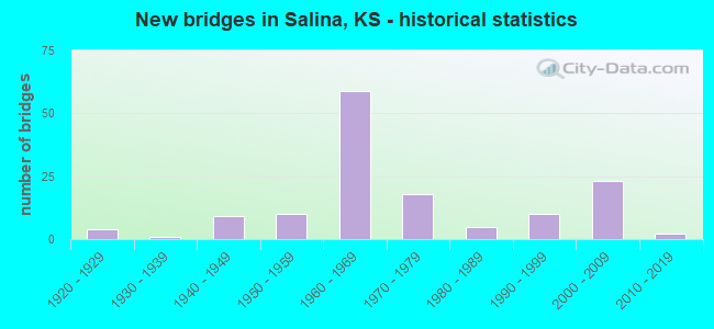
- New bridges - historical statistics
- 41920-1929
- 11930-1939
- 91940-1949
- 101950-1959
- 591960-1969
- 181970-1979
- 51980-1989
- 101990-1999
- 232000-2009
- 22010-2019
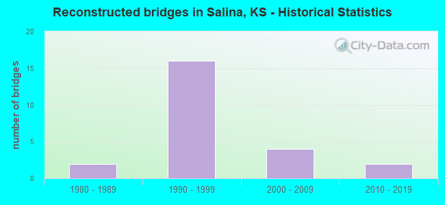
- Reconstructed bridges - Historical Statistics
- 21980-1989
- 161990-1999
- 42000-2009
- 22010-2019
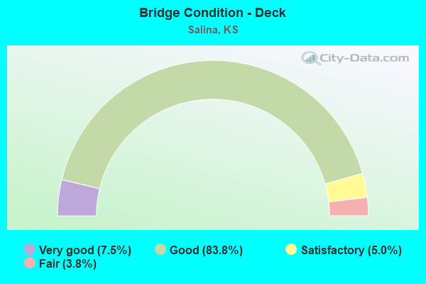
- Bridge Condition - Deck
- 7.5%Very good
- 83.8%Good
- 5.0%Satisfactory
- 3.8%Fair
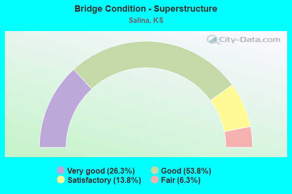
- Bridge Condition - Superstructure
- 26.3%Very good
- 53.8%Good
- 13.8%Satisfactory
- 6.3%Fair
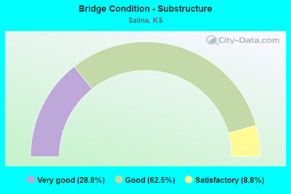
- Bridge Condition - Substructure
- 28.8%Very good
- 62.5%Good
- 8.8%Satisfactory
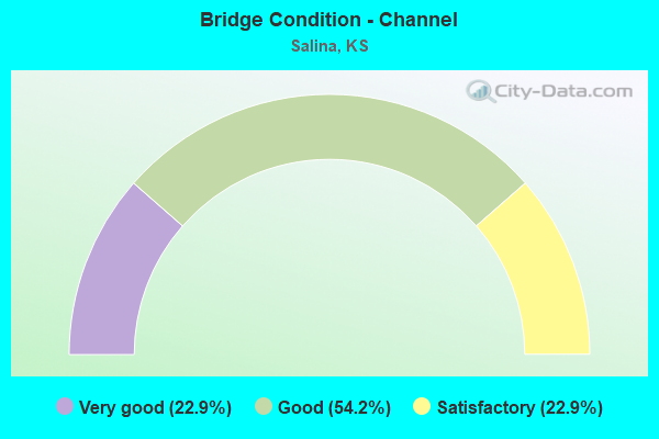
- Bridge Condition - Channel
- 22.9%Very good
- 54.2%Good
- 22.9%Satisfactory
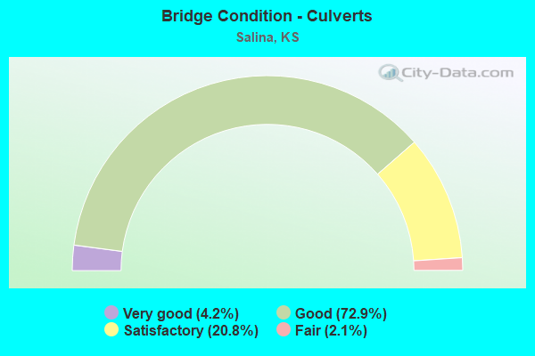
- Bridge Condition - Culverts
- 4.2%Very good
- 72.9%Good
- 20.8%Satisfactory
- 2.1%Fair
Find on map >> Show street view
Structure Number: 999908100850901, Location: 3.17 MI N I70, SB (Lat: 38.920278, Lng: -97.645278), Route carried "on" structure: US 81, Year Built: 1970, Year Reconstructed: 2002, Status: Open, Structure Length: 11.07m (36.32ft), Average Daily Traffic: 4,531 (year 2020), Truck Traffic: 27%, Average Future Daily Traffic: 6,733 (year 2041), Design Load: HS 20, Features Intersected: SALINE RIVER
Minimum Vertical Clearance: 30.47m (99.97ft), Kilometerpoint: 35.332, Lanes on structure: 2, Base Highway Network: Yes, Owner: State Highway Agency, Approaching Roadway Width: 12.2m (40.0ft), Material/Design: Steel continuous, Design/Construction: Stringer/Multi-beam, Number Of Spans In Main Unit: 4, Length of Maximum Span: 30.5m (100.1ft), Curb-To-Curb Width: 12.2m (40.0ft), Out-to-Out Width: 12.8m (42.0ft)
Condition: Deck: Good, Superstructure: Fair, Substructure: Good, Channel: Very good, Operating Rating: 63.8 metric tons, Method Used To Determine Operating Rating: Load Factor (LF), Inventory Rating: 38.2 metric tons, Method Used To Determine Inventory Rating: Load Factor (LF), Structural Evaluation: Somewhat better than minimum adequacy, Deck Geometry: Better than present minimum criteria, Waterway Adequacy: Meets minimum limits, Approach Roadway Alignment: Equal to present desirable criteria, Length Of Structure Improvement: 36.33m (119.19ft), Designated Inspection Frequency: Every 24 months, Inspection Date: November 2020, Wearing Surface/Protective System: Wearing Surface: Low Slump Concrete, Deck Protection: Epoxy Coated Reinforcing
Find on map >> Show street view
Structure Number: 999908100850911, Location: 3.16 MI N I70, NB (Lat: 38.920278, Lng: -97.645000), Route carried "on" structure: US 81, Year Built: 1970, Year Reconstructed: 2002, Status: Open, Structure Length: 11.07m (36.32ft), Average Daily Traffic: 4,531 (year 2020), Truck Traffic: 27%, Average Future Daily Traffic: 6,733 (year 2041), Design Load: HS 20, Features Intersected: SALINE RIVER
Minimum Vertical Clearance: 30.47m (99.97ft), Kilometerpoint: 35.328, Lanes on structure: 2, Base Highway Network: Yes, Owner: State Highway Agency, Approaching Roadway Width: 12.2m (40.0ft), Material/Design: Steel continuous, Design/Construction: Stringer/Multi-beam, Number Of Spans In Main Unit: 4, Length of Maximum Span: 30.5m (100.1ft), Curb-To-Curb Width: 12.2m (40.0ft), Out-to-Out Width: 12.8m (42.0ft)
Condition: Deck: Good, Superstructure: Fair, Substructure: Good, Channel: Good, Operating Rating: 63.8 metric tons, Method Used To Determine Operating Rating: Load Factor (LF), Inventory Rating: 38.2 metric tons, Method Used To Determine Inventory Rating: Load Factor (LF), Structural Evaluation: Somewhat better than minimum adequacy, Deck Geometry: Better than present minimum criteria, Waterway Adequacy: Somewhat better than minimum adequacy, Approach Roadway Alignment: Equal to present desirable criteria, Length Of Structure Improvement: 36.33m (119.19ft), Designated Inspection Frequency: Every 24 months, Inspection Date: November 2020, Wearing Surface/Protective System: Wearing Surface: Low Slump Concrete, Deck Protection: Epoxy Coated Reinforcing
Find on map >> Show street view
Structure Number: 999908100850921, Location: 3.43 MI N I70 (Lat: 38.923889, Lng: -97.644444), Route carried "on" structure: US 81, Year Built: 1970, Year Reconstructed: 2004, Status: Open, Structure Length: 0.77m (2.53ft), Average Daily Traffic: 4,531 (year 2020), Truck Traffic: 27%, Average Future Daily Traffic: 6,733 (year 2041), Design Load: H 20, Features Intersected: SALINE RIVER DRAINAGE
Minimum Vertical Clearance: 30.47m (99.97ft), Kilometerpoint: 35.753, Lanes on structure: 4, Base Highway Network: Yes, Owner: State Highway Agency, Approaching Roadway Width: 24.4m (80.1ft), Skew: 20 degrees, Material/Design: Concrete, Design/Construction: Culvert, Number Of Spans In Main Unit: 3, Length of Maximum Span: 2.4m (7.9ft), Curb-To-Curb Width: 24.4m (80.1ft), Out-to-Out Width: 63.6m (208.7ft)
Condition: Channel: Very good, Culverts: Good, Operating Rating: 89.8 metric tons, Method Used To Determine Operating Rating: Load Factor (LF), Inventory Rating: 89.8 metric tons, Method Used To Determine Inventory Rating: Load Factor (LF), Structural Evaluation: Better than present minimum criteria, Deck Geometry: Superior to present desirable criteria, Waterway Adequacy: Better than present minimum criteria, Approach Roadway Alignment: Equal to present desirable criteria, Length Of Structure Improvement: 2.53m (8.30ft), Designated Inspection Frequency: Every 24 months, Inspection Date: November 2020, Deck Structure Type: Concrete Cast-file-Place, Wearing Surface/Protective System: Wearing Surface: Bituminous
Find on map >> Show street view
Structure Number: 999908100850931, Location: JCT K143 SB (Lat: 38.928611, Lng: -97.643333), Route carried "on" structure: US 81, Year Built: 1970, Status: Open, Structure Length: 5.44m (17.85ft), Average Daily Traffic: 4,531 (year 2020), Truck Traffic: 27%, Average Future Daily Traffic: 6,733 (year 2041), Design Load: HS 20, Features Intersected: RS1049, K143 HWY
Minimum Vertical Clearance: 30.47m (99.97ft), Kilometerpoint: 36.275, Lanes on structure: 2, Lanes under structure: 4, Base Highway Network: Yes, Owner: State Highway Agency, Approaching Roadway Width: 12.2m (40.0ft), Material/Design: Concrete continuous, Design/Construction: Slab, Number Of Spans In Main Unit: 4, Length of Maximum Span: 15.2m (49.9ft), Curb-To-Curb Width: 12.2m (40.0ft), Out-to-Out Width: 12.8m (42.0ft)
Condition: Deck: Good, Superstructure: Good, Substructure: Good, Operating Rating: 59.0 metric tons, Method Used To Determine Operating Rating: Load Factor (LF), Inventory Rating: 35.4 metric tons, Method Used To Determine Inventory Rating: Load Factor (LF), Structural Evaluation: Better than present minimum criteria, Deck Geometry: Better than present minimum criteria, Underclear: Equal to present minimum criteria, Approach Roadway Alignment: Equal to present desirable criteria, Length Of Structure Improvement: 17.85m (58.56ft), Designated Inspection Frequency: Every 24 months, Inspection Date: November 2020, Deck Structure Type: Concrete Cast-file-Place, Wearing Surface/Protective System: Wearing Surface: Low Slump Concrete
Find on map >> Show street view
Structure Number: 999908100850941, Location: JCT K143 NB (Lat: 38.928611, Lng: -97.643056), Route carried "on" structure: US 81, Year Built: 1970, Status: Open, Structure Length: 5.44m (17.85ft), Average Daily Traffic: 4,531 (year 2020), Truck Traffic: 27%, Average Future Daily Traffic: 6,733 (year 2041), Design Load: HS 20, Features Intersected: RS1049, K143 HWY
Minimum Vertical Clearance: 30.47m (99.97ft), Kilometerpoint: 36.270, Lanes on structure: 2, Lanes under structure: 4, Base Highway Network: Yes, Owner: State Highway Agency, Approaching Roadway Width: 12.2m (40.0ft), Material/Design: Concrete continuous, Design/Construction: Slab, Number Of Spans In Main Unit: 4, Length of Maximum Span: 15.2m (49.9ft), Curb-To-Curb Width: 12.2m (40.0ft), Out-to-Out Width: 12.8m (42.0ft)
Condition: Deck: Good, Superstructure: Good, Substructure: Good, Operating Rating: 59.0 metric tons, Method Used To Determine Operating Rating: Load Factor (LF), Inventory Rating: 35.4 metric tons, Method Used To Determine Inventory Rating: Load Factor (LF), Structural Evaluation: Better than present minimum criteria, Deck Geometry: Better than present minimum criteria, Underclear: Better than present minimum criteria, Approach Roadway Alignment: Equal to present desirable criteria, Length Of Structure Improvement: 17.85m (58.56ft), Designated Inspection Frequency: Every 24 months, Inspection Date: November 2020, Deck Structure Type: Concrete Cast-file-Place, Wearing Surface/Protective System: Wearing Surface: Low Slump Concrete
Find on map >> Show street view
Structure Number: 999910400851571, Location: 1.76 MI N K4 (Lat: 38.736389, Lng: -97.613056), Route carried "on" structure: State highway 104, Year Built: 2000, Status: Open, Structure Length: 6.11m (20.05ft), Average Daily Traffic: 2,905 (year 2020), Truck Traffic: 6%, Average Future Daily Traffic: 3,761 (year 2041), Design Load: HS 20, Features Intersected: DRY CREEK
Minimum Vertical Clearance: 30.47m (99.97ft), Kilometerpoint: 2.826, Lanes on structure: 2, Base Highway Network: Yes, Owner: State Highway Agency, Approaching Roadway Width: 8.5m (27.9ft), Skew: 1 degrees, Material/Design: Prestressed concrete continuous, Design/Construction: Stringer/Multi-beam, Number Of Spans In Main Unit: 3, Length of Maximum Span: 20.3m (66.6ft), Curb-To-Curb Width: 12.2m (40.0ft), Out-to-Out Width: 12.8m (42.0ft)
Condition: Deck: Very good, Superstructure: Very good, Substructure: Very good, Channel: Very good, Operating Rating: 89.8 metric tons, Method Used To Determine Operating Rating: Load Factor (LF), Inventory Rating: 57.5 metric tons, Method Used To Determine Inventory Rating: Load Factor (LF), Structural Evaluation: Equal to present desirable criteria, Deck Geometry: Equal to present minimum criteria, Waterway Adequacy: Equal to present desirable criteria, Approach Roadway Alignment: Somewhat better than minimum adequacy, Length Of Structure Improvement: 20.05m (65.78ft), Designated Inspection Frequency: Every 24 months, Inspection Date: April 2020, Wearing Surface/Protective System: Wearing Surface: Monolithic Concrete, Deck Protection: Epoxy Coated Reinforcing
Find on map >> Show street view
Structure Number: 999913500850121, Location: 3.03 MI N NJCT K4 (Lat: 38.725278, Lng: -97.620278), Route carried "on" structure: ServiceCounty highway 628, Year Built: 1966, Status: Open, Structure Length: 7.15m (23.46ft), Average Daily Traffic: 39 (year 2020), Average Future Daily Traffic: 11,976 (year 2041), Design Load: H 15, Features Intersected: I135HWY WL-EL, Facility Carried by Structure: LOCAL ROAD
Minimum Vertical Clearance: 30.47m (99.97ft), Kilometerpoint: 0.937, Lanes on structure: 2, Lanes under structure: 4, Owner: State Highway Agency, Approaching Roadway Width: 8.5m (27.9ft), Material/Design: Concrete continuous, Design/Construction: Box Beam or Girders - Multiple, Number Of Spans In Main Unit: 4, Length of Maximum Span: 22.6m (74.1ft), Curb-To-Curb Width: 7.3m (24.0ft), Out-to-Out Width: 7.7m (25.3ft)
Condition: Deck: Good, Superstructure: Good, Substructure: Good, Operating Rating: 52.3 metric tons, Method Used To Determine Operating Rating: Load Factor (LF), Inventory Rating: 31.4 metric tons, Method Used To Determine Inventory Rating: Load Factor (LF), Structural Evaluation: Better than present minimum criteria, Deck Geometry: Equal to present minimum criteria, Underclear: Somewhat better than minimum adequacy, Approach Roadway Alignment: Somewhat better than minimum adequacy, Length Of Structure Improvement: 23.45m (76.94ft), Designated Inspection Frequency: Every 24 months, Inspection Date: November 2020, Deck Structure Type: Concrete Cast-file-Place, Wearing Surface/Protective System: Wearing Surface: Monolithic Concrete
Find on map >> Show street view
Structure Number: 999913500850151, Location: JCT K104/I135, SB (Lat: 38.740000, Lng: -97.618056), Route carried "on" structure: Interstate 135, Year Built: 1966, Status: Open, Structure Length: 3.64m (11.94ft), Average Daily Traffic: 7,690 (year 2020), Truck Traffic: 25%, Average Future Daily Traffic: 12,849 (year 2041), Design Load: HS 20+Mod, Features Intersected: RS0593 LT, K104 HWY RT
Minimum Vertical Clearance: 30.47m (99.97ft), Kilometerpoint: 14.587, Lanes on structure: 2, Lanes under structure: 2, Base Highway Network: Yes, Owner: State Highway Agency, Approaching Roadway Width: 12.2m (40.0ft), Material/Design: Concrete continuous, Design/Construction: Slab, Number Of Spans In Main Unit: 3, Length of Maximum Span: 13.7m (44.9ft), Curb-To-Curb Width: 12.2m (40.0ft), Out-to-Out Width: 12.8m (42.0ft)
Condition: Deck: Good, Superstructure: Good, Substructure: Very good, Operating Rating: 49.0 metric tons, Method Used To Determine Operating Rating: Load Factor (LF), Inventory Rating: 29.0 metric tons, Method Used To Determine Inventory Rating: Load Factor (LF), Structural Evaluation: Better than present minimum criteria, Deck Geometry: Better than present minimum criteria, Underclear: Meets minimum limits, Approach Roadway Alignment: Equal to present desirable criteria, Length Of Structure Improvement: 11.95m (39.21ft), Designated Inspection Frequency: Every 24 months, Inspection Date: November 2020, Deck Structure Type: Concrete Cast-file-Place, Wearing Surface/Protective System: Wearing Surface: Low Slump Concrete
Find on map >> Show street view
Structure Number: 999913500850161, Location: JCT K104/I135, NB (Lat: 38.740000, Lng: -97.617778), Route carried "on" structure: Interstate 135, Year Built: 1966, Status: Open, Structure Length: 3.64m (11.94ft), Average Daily Traffic: 7,690 (year 2020), Truck Traffic: 25%, Average Future Daily Traffic: 12,849 (year 2041), Design Load: HS 20+Mod, Features Intersected: RS0593 LT, K104 HWY RT
Minimum Vertical Clearance: 30.47m (99.97ft), Kilometerpoint: 14.589, Lanes on structure: 2, Lanes under structure: 2, Base Highway Network: Yes, Owner: State Highway Agency, Approaching Roadway Width: 12.2m (40.0ft), Material/Design: Concrete continuous, Design/Construction: Slab, Number Of Spans In Main Unit: 3, Length of Maximum Span: 13.7m (44.9ft), Curb-To-Curb Width: 12.2m (40.0ft), Out-to-Out Width: 12.8m (42.0ft)
Condition: Deck: Good, Superstructure: Very good, Substructure: Very good, Operating Rating: 49.0 metric tons, Method Used To Determine Operating Rating: Load Factor (LF), Inventory Rating: 29.0 metric tons, Method Used To Determine Inventory Rating: Load Factor (LF), Structural Evaluation: Better than present minimum criteria, Deck Geometry: Better than present minimum criteria, Underclear: Meets minimum limits, Approach Roadway Alignment: Equal to present desirable criteria, Length Of Structure Improvement: 11.95m (39.21ft), Designated Inspection Frequency: Every 24 months, Inspection Date: November 2020, Deck Structure Type: Concrete Cast-file-Place, Wearing Surface/Protective System: Wearing Surface: Low Slump Concrete
Find on map >> Show street view
Structure Number: 999913500850171, Location: 1.00 MI N K104 (Lat: 38.754444, Lng: -97.618056), Route carried "on" structure: ServiceCounty highway 370, Year Built: 1963, Status: Open, Structure Length: 6.60m (21.65ft), Average Daily Traffic: 39 (year 2020), Average Future Daily Traffic: 13,534 (year 2041), Design Load: H 15, Features Intersected: I135 HWY WL-EL, Facility Carried by Structure: LOCAL ROAD
Minimum Vertical Clearance: 30.47m (99.97ft), Kilometerpoint: 2.031, Lanes on structure: 2, Lanes under structure: 4, Owner: State Highway Agency, Approaching Roadway Width: 7.3m (24.0ft), Material/Design: Concrete continuous, Design/Construction: Box Beam or Girders - Multiple, Number Of Spans In Main Unit: 4, Length of Maximum Span: 20.7m (67.9ft), Curb-To-Curb Width: 7.3m (24.0ft), Out-to-Out Width: 8.0m (26.2ft)
Condition: Deck: Good, Superstructure: Very good, Substructure: Good, Operating Rating: 41.7 metric tons, Method Used To Determine Operating Rating: Load Factor (LF), Inventory Rating: 24.5 metric tons, Method Used To Determine Inventory Rating: Load Factor (LF), Structural Evaluation: Equal to present minimum criteria, Deck Geometry: Equal to present minimum criteria, Underclear: Equal to present minimum criteria, Approach Roadway Alignment: Somewhat better than minimum adequacy, Length Of Structure Improvement: 21.65m (71.03ft), Designated Inspection Frequency: Every 24 months, Inspection Date: November 2020, Deck Structure Type: Concrete Cast-file-Place, Wearing Surface/Protective System: Wearing Surface: Monolithic Concrete
Find on map >> Show street view
Structure Number: 999913500850191, Location: 3.02 MI N. of K-104 (Lat: 38.783611, Lng: -97.616944), Route carried "on" structure: Interstate 135, Year Built: 1963, Status: Open, Structure Length: 4.80m (15.75ft), Average Daily Traffic: 8,197 (year 2020), Truck Traffic: 25%, Average Future Daily Traffic: 13,696 (year 2041), Design Load: HS 20+Mod, Features Intersected: Schilling Road
Minimum Vertical Clearance: 30.47m (99.97ft), Kilometerpoint: 19.439, Lanes on structure: 2, Lanes under structure: 4, Base Highway Network: Yes, Owner: State Highway Agency, Approaching Roadway Width: 12.2m (40.0ft), Material/Design: Concrete continuous, Design/Construction: Slab, Number Of Spans In Main Unit: 4, Length of Maximum Span: 13.3m (43.6ft), Curb-To-Curb Width: 12.2m (40.0ft), Out-to-Out Width: 12.7m (41.7ft)
Condition: Deck: Good, Superstructure: Good, Substructure: Very good, Operating Rating: 49.9 metric tons, Method Used To Determine Operating Rating: Load Factor (LF), Inventory Rating: 29.9 metric tons, Method Used To Determine Inventory Rating: Load Factor (LF), Structural Evaluation: Better than present minimum criteria, Deck Geometry: Better than present minimum criteria, Underclear: Meets minimum limits, Approach Roadway Alignment: Equal to present desirable criteria, Length Of Structure Improvement: 15.75m (51.67ft), Designated Inspection Frequency: Every 24 months, Inspection Date: November 2020, Deck Structure Type: Concrete Cast-file-Place, Wearing Surface/Protective System: Wearing Surface: Low Slump Concrete
Find on map >> Show street view
Structure Number: 999913500850201, Location: 3.01 MI N. of K-104 (Lat: 38.783611, Lng: -97.616667), Route carried "on" structure: Interstate 135, Year Built: 1963, Status: Open, Structure Length: 4.80m (15.75ft), Average Daily Traffic: 8,197 (year 2020), Truck Traffic: 25%, Average Future Daily Traffic: 13,696 (year 2041), Design Load: HS 20+Mod, Features Intersected: Schilling Road
Minimum Vertical Clearance: 30.47m (99.97ft), Kilometerpoint: 19.438, Lanes on structure: 2, Lanes under structure: 4, Base Highway Network: Yes, Owner: State Highway Agency, Approaching Roadway Width: 12.2m (40.0ft), Material/Design: Concrete continuous, Design/Construction: Slab, Number Of Spans In Main Unit: 4, Length of Maximum Span: 13.3m (43.6ft), Curb-To-Curb Width: 14.6m (47.9ft), Out-to-Out Width: 15.2m (49.9ft)
Condition: Deck: Good, Superstructure: Good, Substructure: Very good, Operating Rating: 45.4 metric tons, Method Used To Determine Operating Rating: Load Factor (LF), Inventory Rating: 27.2 metric tons, Method Used To Determine Inventory Rating: Load Factor (LF), Structural Evaluation: Equal to present minimum criteria, Deck Geometry: Superior to present desirable criteria, Underclear: Meets minimum limits, Approach Roadway Alignment: Equal to present desirable criteria, Length Of Structure Improvement: 15.75m (51.67ft), Designated Inspection Frequency: Every 24 months, Inspection Date: November 2020, Deck Structure Type: Concrete Cast-file-Place, Wearing Surface/Protective System: Wearing Surface: Low Slump Concrete
Find on map >> Show street view
Structure Number: 999913500850221, Location: 0.87MI N MAGNOLIA ST (Lat: 38.807778, Lng: -97.628333), Route carried "on" structure: Interstate 135, Year Built: 1963, Status: Open, Structure Length: 3.65m (11.98ft), Average Daily Traffic: 11,537 (year 2020), Truck Traffic: 20%, Average Future Daily Traffic: 19,277 (year 2041), Design Load: HS 20+Mod, Features Intersected: UP RAILROAD
Minimum Vertical Clearance: 30.47m (99.97ft), Kilometerpoint: 22.450, Lanes on structure: 2, Base Highway Network: Yes, Owner: State Highway Agency, Approaching Roadway Width: 12.2m (40.0ft), Skew: 1 degrees, Material/Design: Concrete continuous, Design/Construction: Slab, Number Of Spans In Main Unit: 3, Length of Maximum Span: 13.7m (44.9ft), Curb-To-Curb Width: 12.2m (40.0ft), Out-to-Out Width: 12.7m (41.7ft)
Condition: Deck: Good, Superstructure: Good, Substructure: Good, Operating Rating: 48.1 metric tons, Method Used To Determine Operating Rating: Load Factor (LF), Inventory Rating: 29.0 metric tons, Method Used To Determine Inventory Rating: Load Factor (LF), Structural Evaluation: Better than present minimum criteria, Deck Geometry: Better than present minimum criteria, Underclear: Equal to present minimum criteria, Approach Roadway Alignment: Equal to present desirable criteria, Length Of Structure Improvement: 11.96m (39.24ft), Designated Inspection Frequency: Every 24 months, Inspection Date: November 2020, Deck Structure Type: Concrete Cast-file-Place, Wearing Surface/Protective System: Wearing Surface: Low Slump Concrete
Find on map >> Show street view
Structure Number: 999913500850231, Location: 0.88MI N MAGNOLIA ST (Lat: 38.808056, Lng: -97.628056), Route carried "on" structure: Interstate 135, Year Built: 1963, Status: Open, Structure Length: 3.65m (11.98ft), Average Daily Traffic: 11,537 (year 2020), Truck Traffic: 20%, Average Future Daily Traffic: 19,277 (year 2041), Design Load: HS 20+Mod, Features Intersected: UP RAILROAD
Minimum Vertical Clearance: 30.47m (99.97ft), Kilometerpoint: 22.474, Lanes on structure: 2, Base Highway Network: Yes, Owner: State Highway Agency, Approaching Roadway Width: 12.2m (40.0ft), Skew: 1 degrees, Material/Design: Concrete continuous, Design/Construction: Slab, Number Of Spans In Main Unit: 3, Length of Maximum Span: 13.7m (44.9ft), Curb-To-Curb Width: 12.2m (40.0ft), Out-to-Out Width: 12.7m (41.7ft)
Condition: Deck: Very good, Superstructure: Good, Substructure: Good, Operating Rating: 48.1 metric tons, Method Used To Determine Operating Rating: Load Factor (LF), Inventory Rating: 29.0 metric tons, Method Used To Determine Inventory Rating: Load Factor (LF), Structural Evaluation: Better than present minimum criteria, Deck Geometry: Better than present minimum criteria, Underclear: Better than present minimum criteria, Approach Roadway Alignment: Equal to present desirable criteria, Length Of Structure Improvement: 11.96m (39.24ft), Designated Inspection Frequency: Every 24 months, Inspection Date: November 2020, Deck Structure Type: Concrete Cast-file-Place, Wearing Surface/Protective System: Wearing Surface: Low Slump Concrete
Find on map >> Show street view
Structure Number: 999913500850241, Location: 1.06MI N MAGNOLIA ST (Lat: 38.810000, Lng: -97.630556), Route carried "on" structure: Interstate 135, Year Built: 1963, Year Reconstructed: 1999, Status: Open, Structure Length: 1.30m (4.27ft), Average Daily Traffic: 11,537 (year 2020), Truck Traffic: 20%, Average Future Daily Traffic: 19,277 (year 2041), Design Load: H 20, Features Intersected: DRY CREEK
Minimum Vertical Clearance: 30.47m (99.97ft), Kilometerpoint: 22.793, Lanes on structure: 4, Base Highway Network: Yes, Owner: State Highway Agency, Approaching Roadway Width: 24.4m (80.1ft), Skew: 23 degrees, Material/Design: Concrete, Design/Construction: Culvert, Number Of Spans In Main Unit: 2, Length of Maximum Span: 5.5m (18.0ft), Curb-To-Curb Width: 39.0m (128.0ft), Out-to-Out Width: 105.0m (344.5ft)
Condition: Channel: Good, Culverts: Good, Operating Rating: 89.8 metric tons, Method Used To Determine Operating Rating: Load Factor (LF), Inventory Rating: 89.8 metric tons, Method Used To Determine Inventory Rating: Load Factor (LF), Structural Evaluation: Better than present minimum criteria, Deck Geometry: Superior to present desirable criteria, Waterway Adequacy: Better than present minimum criteria, Approach Roadway Alignment: Equal to present desirable criteria, Length Of Structure Improvement: 4.28m (14.04ft), Designated Inspection Frequency: Every 24 months, Inspection Date: November 2020, Deck Structure Type: Concrete Cast-file-Place, Wearing Surface/Protective System: Wearing Surface: Monolithic Concrete
Find on map >> Show street view
Structure Number: 999913500850271, Location: 2.35MI N MAGNOLIA ST (Lat: 38.826944, Lng: -97.639722), Route carried "on" structure: City street 4816, Year Built: 1963, Status: Open, Structure Length: 6.88m (22.57ft), Average Daily Traffic: 9,625 (year 2020), Average Future Daily Traffic: 11,744 (year 2041), Design Load: H 20, Features Intersected: I135 HWY WL-EL
Minimum Vertical Clearance: 30.47m (99.97ft), Kilometerpoint: 0.869, Lanes on structure: 4, Lanes under structure: 4, Owner: State Highway Agency, Approaching Roadway Width: 17.7m (58.1ft), Skew: 1 degrees, Material/Design: Concrete continuous, Design/Construction: Slab, Number Of Spans In Main Unit: 4, Length of Maximum Span: 21.6m (70.9ft), Curb-To-Curb Width: 17.7m (58.1ft), Out-to-Out Width: 18.4m (60.4ft)
Condition: Deck: Good, Superstructure: Satisfactory, Substructure: Good, Operating Rating: 57.2 metric tons, Method Used To Determine Operating Rating: Load Factor (LF), Inventory Rating: 34.5 metric tons, Method Used To Determine Inventory Rating: Load Factor (LF), Structural Evaluation: Equal to present minimum criteria, Deck Geometry: Somewhat better than minimum adequacy, Underclear: Meets minimum limits, Approach Roadway Alignment: Meets minimum limits, Length Of Structure Improvement: 22.56m (74.02ft), Designated Inspection Frequency: Every 24 months, Inspection Date: November 2020, Deck Structure Type: Concrete Cast-file-Place, Wearing Surface/Protective System: Wearing Surface: Low Slump Concrete
Find on map >> Show street view
Structure Number: 999913500850281, Location: 3.23MI N MAGNOLIA ST (Lat: 38.838889, Lng: -97.645278), Route carried "on" structure: Interstate 135, Year Built: 1963, Year Reconstructed: 2000, Status: Open, Structure Length: 8.55m (28.05ft), Average Daily Traffic: 10,776 (year 2020), Truck Traffic: 21%, Average Future Daily Traffic: 18,005 (year 2041), Design Load: HS 20+Mod, Features Intersected: UP RAILROAD & STREAM
Minimum Vertical Clearance: 30.47m (99.97ft), Kilometerpoint: 26.236, Lanes on structure: 3, Base Highway Network: Yes, Owner: State Highway Agency, Approaching Roadway Width: 15.2m (49.9ft), Material/Design: Concrete continuous, Design/Construction: Slab, Number Of Spans In Main Unit: 7, Length of Maximum Span: 12.8m (42.0ft), Curb-To-Curb Width: 15.3m (50.2ft), Out-to-Out Width: 15.9m (52.2ft)
Condition: Deck: Satisfactory, Superstructure: Good, Substructure: Good, Channel: Good, Operating Rating: 56.2 metric tons, Method Used To Determine Operating Rating: Load Factor (LF), Inventory Rating: 33.6 metric tons, Method Used To Determine Inventory Rating: Load Factor (LF), Structural Evaluation: Better than present minimum criteria, Deck Geometry: Meets minimum limits, Underclear: Superior to present desirable criteria, Waterway Adequacy: Equal to present desirable criteria, Approach Roadway Alignment: Equal to present desirable criteria, Length Of Structure Improvement: 28.05m (92.03ft), Designated Inspection Frequency: Every 24 months, Inspection Date: November 2020, Deck Structure Type: Concrete Cast-file-Place, Wearing Surface/Protective System: Wearing Surface: Low Slump Concrete
Find on map >> Show street view
Structure Number: 999913500850291, Location: 3.22MI N MAGNOLIA ST (Lat: 38.838889, Lng: -97.645000), Route carried "on" structure: Interstate 135, Year Built: 1963, Year Reconstructed: 2000, Status: Open, Structure Length: 8.55m (28.05ft), Average Daily Traffic: 10,776 (year 2020), Truck Traffic: 21%, Average Future Daily Traffic: 18,005 (year 2041), Design Load: HS 20+Mod, Features Intersected: UP RAILROAD & STREAM
Minimum Vertical Clearance: 30.47m (99.97ft), Kilometerpoint: 26.245, Lanes on structure: 3, Base Highway Network: Yes, Owner: State Highway Agency, Approaching Roadway Width: 15.2m (49.9ft), Material/Design: Concrete continuous, Design/Construction: Slab, Number Of Spans In Main Unit: 7, Length of Maximum Span: 12.8m (42.0ft), Curb-To-Curb Width: 15.3m (50.2ft), Out-to-Out Width: 15.9m (52.2ft)
Condition: Deck: Good, Superstructure: Good, Substructure: Good, Channel: Very good, Operating Rating: 56.2 metric tons, Method Used To Determine Operating Rating: Load Factor (LF), Inventory Rating: 33.6 metric tons, Method Used To Determine Inventory Rating: Load Factor (LF), Structural Evaluation: Better than present minimum criteria, Deck Geometry: Meets minimum limits, Underclear: Equal to present minimum criteria, Waterway Adequacy: Equal to present desirable criteria, Approach Roadway Alignment: Better than present minimum criteria, Length Of Structure Improvement: 28.05m (92.03ft), Designated Inspection Frequency: Every 24 months, Inspection Date: November 2020, Deck Structure Type: Concrete Cast-file-Place, Wearing Surface/Protective System: Wearing Surface: Low Slump Concrete
Find on map >> Show street view
Structure Number: 999913500850301, Location: JCT K140/I135 SB (Lat: 38.841389, Lng: -97.646389), Route carried "on" structure: Interstate 135, Year Built: 1963, Status: Open, Structure Length: 5.02m (16.47ft), Average Daily Traffic: 9,360 (year 2020), Truck Traffic: 25%, Average Future Daily Traffic: 15,640 (year 2041), Design Load: HS 20+Mod, Features Intersected: K140 HIGHWAY
Minimum Vertical Clearance: 30.47m (99.97ft), Kilometerpoint: 26.527, Lanes on structure: 2, Lanes under structure: 6, Base Highway Network: Yes, Owner: State Highway Agency, Approaching Roadway Width: 12.2m (40.0ft), Material/Design: Concrete continuous, Design/Construction: Slab, Number Of Spans In Main Unit: 4, Length of Maximum Span: 13.8m (45.3ft), Curb-To-Curb Width: 12.2m (40.0ft), Out-to-Out Width: 12.7m (41.7ft)
Condition: Deck: Good, Superstructure: Good, Substructure: Good, Operating Rating: 44.5 metric tons, Method Used To Determine Operating Rating: Load Factor (LF), Inventory Rating: 26.3 metric tons, Method Used To Determine Inventory Rating: Load Factor (LF), Structural Evaluation: Equal to present minimum criteria, Deck Geometry: Better than present minimum criteria, Underclear: Equal to present minimum criteria, Approach Roadway Alignment: Equal to present desirable criteria, Length Of Structure Improvement: 16.48m (54.07ft), Designated Inspection Frequency: Every 24 months, Inspection Date: November 2020, Deck Structure Type: Concrete Cast-file-Place, Wearing Surface/Protective System: Wearing Surface: Low Slump Concrete
Find on map >> Show street view
Structure Number: 999913500850311, Location: JCT K140/I135, NB (Lat: 38.841389, Lng: -97.646111), Route carried "on" structure: Interstate 135, Year Built: 1963, Status: Open, Structure Length: 5.02m (16.47ft), Average Daily Traffic: 9,360 (year 2020), Truck Traffic: 25%, Average Future Daily Traffic: 15,640 (year 2041), Design Load: HS 20+Mod, Features Intersected: K140 HIGHWAY
Minimum Vertical Clearance: 30.47m (99.97ft), Kilometerpoint: 26.535, Lanes on structure: 2, Lanes under structure: 6, Base Highway Network: Yes, Owner: State Highway Agency, Approaching Roadway Width: 12.2m (40.0ft), Material/Design: Concrete continuous, Design/Construction: Slab, Number Of Spans In Main Unit: 4, Length of Maximum Span: 13.8m (45.3ft), Curb-To-Curb Width: 12.2m (40.0ft), Out-to-Out Width: 12.7m (41.7ft)
Condition: Deck: Good, Superstructure: Good, Substructure: Good, Operating Rating: 44.5 metric tons, Method Used To Determine Operating Rating: Load Factor (LF), Inventory Rating: 26.3 metric tons, Method Used To Determine Inventory Rating: Load Factor (LF), Structural Evaluation: Equal to present minimum criteria, Deck Geometry: Better than present minimum criteria, Underclear: High priority of corrective action, Approach Roadway Alignment: Equal to present desirable criteria, Length Of Structure Improvement: 16.48m (54.07ft), Designated Inspection Frequency: Every 24 months, Inspection Date: November 2020, Deck Structure Type: Concrete Cast-file-Place, Wearing Surface/Protective System: Wearing Surface: Low Slump Concrete
Find on map >> Show street view
Structure Number: 999913500850321, Location: 0.39 MI N K140 (Lat: 38.846944, Lng: -97.647778), Route carried "on" structure: Interstate 135, Year Built: 1963, Status: Open, Structure Length: 7.39m (24.25ft), Average Daily Traffic: 9,360 (year 2020), Truck Traffic: 25%, Average Future Daily Traffic: 15,640 (year 2041), Design Load: HS 20+Mod, Features Intersected: DRY CREEK DRAINAGE
Minimum Vertical Clearance: 30.47m (99.97ft), Kilometerpoint: 27.175, Lanes on structure: 2, Base Highway Network: Yes, Owner: State Highway Agency, Approaching Roadway Width: 12.2m (40.0ft), Material/Design: Concrete continuous, Design/Construction: Slab, Number Of Spans In Main Unit: 10, Length of Maximum Span: 7.6m (24.9ft), Curb-To-Curb Width: 12.2m (40.0ft), Out-to-Out Width: 12.8m (42.0ft)
Condition: Deck: Good, Superstructure: Satisfactory, Substructure: Good, Channel: Good, Operating Rating: 40.8 metric tons, Method Used To Determine Operating Rating: Load Factor (LF), Inventory Rating: 24.4 metric tons, Method Used To Determine Inventory Rating: Load Factor (LF), Structural Evaluation: Equal to present minimum criteria, Deck Geometry: Better than present minimum criteria, Waterway Adequacy: Better than present minimum criteria, Approach Roadway Alignment: Equal to present desirable criteria, Length Of Structure Improvement: 24.25m (79.56ft), Designated Inspection Frequency: Every 24 months, Inspection Date: November 2020, Deck Structure Type: Concrete Cast-file-Place, Wearing Surface/Protective System: Wearing Surface: Low Slump Concrete
Find on map >> Show street view
Structure Number: 999913500850331, Location: 0.40 MI N K140 (Lat: 38.846944, Lng: -97.647500), Route carried "on" structure: Interstate 135, Year Built: 1963, Status: Open, Structure Length: 7.39m (24.25ft), Average Daily Traffic: 9,360 (year 2020), Truck Traffic: 25%, Average Future Daily Traffic: 15,640 (year 2041), Design Load: HS 20+Mod, Features Intersected: DRY CREEK DRAINAGE
Minimum Vertical Clearance: 30.47m (99.97ft), Kilometerpoint: 27.175, Lanes on structure: 2, Base Highway Network: Yes, Owner: State Highway Agency, Approaching Roadway Width: 12.2m (40.0ft), Material/Design: Concrete continuous, Design/Construction: Slab, Number Of Spans In Main Unit: 10, Length of Maximum Span: 7.6m (24.9ft), Curb-To-Curb Width: 12.2m (40.0ft), Out-to-Out Width: 12.7m (41.7ft)
Condition: Deck: Satisfactory, Superstructure: Satisfactory, Substructure: Good, Channel: Good, Operating Rating: 40.8 metric tons, Method Used To Determine Operating Rating: Load Factor (LF), Inventory Rating: 24.4 metric tons, Method Used To Determine Inventory Rating: Load Factor (LF), Structural Evaluation: Equal to present minimum criteria, Deck Geometry: Better than present minimum criteria, Waterway Adequacy: Better than present minimum criteria, Approach Roadway Alignment: Equal to present desirable criteria, Length Of Structure Improvement: 24.25m (79.56ft), Designated Inspection Frequency: Every 24 months, Inspection Date: November 2020, Deck Structure Type: Concrete Cast-file-Place, Wearing Surface/Protective System: Wearing Surface: Low Slump Concrete
Find on map >> Show street view
Structure Number: 999913500850341, Location: 0.75 MI N K140 (Lat: 38.852222, Lng: -97.646667), Route carried "on" structure: Interstate 135, Year Built: 1963, Status: Open, Structure Length: 3.65m (11.98ft), Average Daily Traffic: 9,360 (year 2020), Truck Traffic: 25%, Average Future Daily Traffic: 15,640 (year 2041), Design Load: HS 20+Mod, Features Intersected: KO RAILWAY
Minimum Vertical Clearance: 30.47m (99.97ft), Kilometerpoint: 27.760, Lanes on structure: 2, Base Highway Network: Yes, Owner: State Highway Agency, Approaching Roadway Width: 12.2m (40.0ft), Skew: 1 degrees, Material/Design: Concrete continuous, Design/Construction: Slab, Number Of Spans In Main Unit: 3, Length of Maximum Span: 13.7m (44.9ft), Curb-To-Curb Width: 12.2m (40.0ft), Out-to-Out Width: 12.7m (41.7ft)
Condition: Deck: Good, Superstructure: Good, Substructure: Good, Operating Rating: 48.1 metric tons, Method Used To Determine Operating Rating: Load Factor (LF), Inventory Rating: 29.0 metric tons, Method Used To Determine Inventory Rating: Load Factor (LF), Structural Evaluation: Better than present minimum criteria, Deck Geometry: Better than present minimum criteria, Underclear: Superior to present desirable criteria, Approach Roadway Alignment: Equal to present desirable criteria, Length Of Structure Improvement: 11.96m (39.24ft), Designated Inspection Frequency: Every 24 months, Inspection Date: November 2020, Deck Structure Type: Concrete Cast-file-Place, Wearing Surface/Protective System: Wearing Surface: Low Slump Concrete
Find on map >> Show street view
Structure Number: 999913500850351, Location: 0.74 MI N K140 (Lat: 38.851944, Lng: -97.646389), Route carried "on" structure: Interstate 135, Year Built: 1963, Status: Open, Structure Length: 3.65m (11.98ft), Average Daily Traffic: 9,360 (year 2020), Truck Traffic: 25%, Average Future Daily Traffic: 15,640 (year 2041), Design Load: HS 20+Mod, Features Intersected: KO RAILWAY
Minimum Vertical Clearance: 30.47m (99.97ft), Kilometerpoint: 27.743, Lanes on structure: 2, Base Highway Network: Yes, Owner: State Highway Agency, Approaching Roadway Width: 12.2m (40.0ft), Skew: 1 degrees, Material/Design: Concrete continuous, Design/Construction: Slab, Number Of Spans In Main Unit: 3, Length of Maximum Span: 13.7m (44.9ft), Curb-To-Curb Width: 12.2m (40.0ft), Out-to-Out Width: 12.7m (41.7ft)
Condition: Deck: Good, Superstructure: Good, Substructure: Good, Operating Rating: 48.1 metric tons, Method Used To Determine Operating Rating: Load Factor (LF), Inventory Rating: 29.0 metric tons, Method Used To Determine Inventory Rating: Load Factor (LF), Structural Evaluation: Better than present minimum criteria, Deck Geometry: Better than present minimum criteria, Underclear: Superior to present desirable criteria, Approach Roadway Alignment: Equal to present desirable criteria, Length Of Structure Improvement: 11.96m (39.24ft), Designated Inspection Frequency: Every 24 months, Inspection Date: November 2020, Deck Structure Type: Concrete Cast-file-Place, Wearing Surface/Protective System: Wearing Surface: Low Slump Concrete
Find on map >> Show street view
Structure Number: 999913500850361, Location: 1.01 MI N K140 (Lat: 38.855833, Lng: -97.646111), Route carried "on" structure: Interstate 135, Year Built: 1963, Status: Open, Structure Length: 6.81m (22.34ft), Average Daily Traffic: 9,360 (year 2020), Truck Traffic: 25%, Average Future Daily Traffic: 15,640 (year 2041), Design Load: HS 20+Mod, Features Intersected: MULBERRY CREEK
Minimum Vertical Clearance: 30.47m (99.97ft), Kilometerpoint: 28.176, Lanes on structure: 2, Base Highway Network: Yes, Owner: State Highway Agency, Approaching Roadway Width: 12.2m (40.0ft), Material/Design: Concrete continuous, Design/Construction: Tee Beam, Number Of Spans In Main Unit: 3, Length of Maximum Span: 27.7m (90.9ft), Curb-To-Curb Width: 12.2m (40.0ft), Out-to-Out Width: 12.8m (42.0ft)
Condition: Deck: Satisfactory, Superstructure: Satisfactory, Substructure: Good, Channel: Very good, Operating Rating: 46.0 metric tons, Method Used To Determine Operating Rating: Load Factor (LF), Inventory Rating: 28.9 metric tons, Method Used To Determine Inventory Rating: Load Factor (LF), Structural Evaluation: Equal to present minimum criteria, Deck Geometry: Better than present minimum criteria, Waterway Adequacy: Better than present minimum criteria, Approach Roadway Alignment: Equal to present desirable criteria, Length Of Structure Improvement: 22.35m (73.33ft), Designated Inspection Frequency: Every 24 months, Inspection Date: November 2020, Deck Structure Type: Concrete Cast-file-Place, Wearing Surface/Protective System: Wearing Surface: Low Slump Concrete
Find on map >> Show street view
Structure Number: 999913500850371, Location: 1.02 MI N K140 (Lat: 38.855833, Lng: -97.645833), Route carried "on" structure: Interstate 135, Year Built: 1963, Status: Open, Structure Length: 6.81m (22.34ft), Average Daily Traffic: 9,360 (year 2020), Truck Traffic: 25%, Average Future Daily Traffic: 15,640 (year 2041), Design Load: HS 20+Mod, Features Intersected: MULBERRY CREEK
Minimum Vertical Clearance: 30.47m (99.97ft), Kilometerpoint: 28.172, Lanes on structure: 2, Base Highway Network: Yes, Owner: State Highway Agency, Approaching Roadway Width: 12.2m (40.0ft), Material/Design: Concrete continuous, Design/Construction: Tee Beam, Number Of Spans In Main Unit: 3, Length of Maximum Span: 27.7m (90.9ft), Curb-To-Curb Width: 12.2m (40.0ft), Out-to-Out Width: 12.8m (42.0ft)
Condition: Deck: Satisfactory, Superstructure: Satisfactory, Substructure: Good, Channel: Good, Operating Rating: 46.0 metric tons, Method Used To Determine Operating Rating: Load Factor (LF), Inventory Rating: 28.9 metric tons, Method Used To Determine Inventory Rating: Load Factor (LF), Structural Evaluation: Equal to present minimum criteria, Deck Geometry: Better than present minimum criteria, Waterway Adequacy: Better than present minimum criteria, Approach Roadway Alignment: Equal to present desirable criteria, Length Of Structure Improvement: 22.35m (73.33ft), Designated Inspection Frequency: Every 24 months, Inspection Date: November 2020, Deck Structure Type: Concrete Cast-file-Place, Wearing Surface/Protective System: Wearing Surface: Low Slump Concrete
Find on map >> Show street view
Structure Number: 999913500850391, Location: JCT I70/I135, SB (Lat: 38.874444, Lng: -97.645556), Route carried "on" structure: US 81, Year Built: 1963, Status: Open, Structure Length: 7.36m (24.15ft), Average Daily Traffic: 4,531 (year 2020), Truck Traffic: 27%, Average Future Daily Traffic: 6,733 (year 2041), Design Load: HS 20+Mod, Features Intersected: I70 HIGHWAY, Facility Carried by Structure: I135 HWY SB
Minimum Vertical Clearance: 30.47m (99.97ft), Kilometerpoint: 30.236, Lanes on structure: 3, Lanes under structure: 6, Base Highway Network: Yes, Owner: State Highway Agency, Approaching Roadway Width: 12.2m (40.0ft), Material/Design: Concrete continuous, Design/Construction: Box Beam or Girders - Multiple, Number Of Spans In Main Unit: 4, Length of Maximum Span: 23.2m (76.1ft), Curb-To-Curb Width: 14.6m (47.9ft), Out-to-Out Width: 15.2m (49.9ft)
Condition: Deck: Good, Superstructure: Fair, Substructure: Good, Operating Rating: 64.6 metric tons, Method Used To Determine Operating Rating: Load Factor (LF), Inventory Rating: 38.6 metric tons, Method Used To Determine Inventory Rating: Load Factor (LF), Structural Evaluation: Somewhat better than minimum adequacy, Deck Geometry: Somewhat better than minimum adequacy, Underclear: High priority of corrective action, Approach Roadway Alignment: Equal to present desirable criteria, Length Of Structure Improvement: 24.15m (79.23ft), Designated Inspection Frequency: Every 24 months, Inspection Date: November 2020, Deck Structure Type: Concrete Cast-file-Place, Wearing Surface/Protective System: Wearing Surface: Low Slump Concrete
Find on map >> Show street view
Structure Number: 999913500850401, Location: JCT I70/I135, NB (Lat: 38.874444, Lng: -97.645000), Route carried "on" structure: US 81, Year Built: 1970, Year Reconstructed: 2021, Status: Open, Structure Length: 7.44m (24.41ft), Average Daily Traffic: 4,531 (year 2020), Truck Traffic: 27%, Average Future Daily Traffic: 6,733 (year 2041), Design Load: HS 20+Mod, Features Intersected: I70 HIGHWAY, Facility Carried by Structure: I135 HWY NB
Minimum Vertical Clearance: 30.47m (99.97ft), Kilometerpoint: 30.236, Lanes on structure: 3, Lanes under structure: 6, Base Highway Network: Yes, Owner: State Highway Agency, Approaching Roadway Width: 12.2m (40.0ft), Material/Design: Steel continuous, Design/Construction: Stringer/Multi-beam, Number Of Spans In Main Unit: 4, Length of Maximum Span: 23.2m (76.1ft), Curb-To-Curb Width: 14.6m (47.9ft), Out-to-Out Width: 15.2m (49.9ft)
Condition: Deck: Good, Superstructure: Good, Substructure: Satisfactory, Operating Rating: 70.8 metric tons, Method Used To Determine Operating Rating: Load Factor (LF), Inventory Rating: 41.7 metric tons, Method Used To Determine Inventory Rating: Load Factor (LF), Structural Evaluation: Equal to present minimum criteria, Deck Geometry: Somewhat better than minimum adequacy, Underclear: High priority of corrective action, Approach Roadway Alignment: Equal to present desirable criteria, Length Of Structure Improvement: 24.41m (80.09ft), Designated Inspection Frequency: Every 24 months, Inspection Date: October 2021, Wearing Surface/Protective System: Wearing Surface: Low Slump Concrete, Deck Protection: Epoxy Coated Reinforcing
Find on map >> Show street view
Structure Number: 999913500851501, Location: 2.08 MI N OF K-104 (Lat: 38.768611, Lng: -97.617778), Route carried "on" structure: City street 4858, Year Built: 1990, Year Reconstructed: 2004, Status: Open, Structure Length: 12.92m (42.39ft), Average Daily Traffic: 2,595 (year 2020), Average Future Daily Traffic: 2,984 (year 2041), Design Load: HS 20, Features Intersected: I-135 HWY WL-EL, Facility Carried by Structure: WATERWELL ROAD
Minimum Vertical Clearance: 30.47m (99.97ft), Kilometerpoint: 4.413, Lanes on structure: 2, Lanes under structure: 4, Owner: State Highway Agency, Approaching Roadway Width: 11.0m (36.1ft), Material/Design: Prestressed concrete continuous, Design/Construction: Stringer/Multi-beam, Number Of Spans In Main Unit: 5, Length of Maximum Span: 33.7m (110.6ft), Curb-To-Curb Width: 15.8m (51.8ft), Out-to-Out Width: 16.5m (54.1ft)
Condition: Deck: Good, Superstructure: Very good, Substructure: Good, Operating Rating: 61.1 metric tons, Method Used To Determine Operating Rating: Load Factor (LF), Inventory Rating: 27.1 metric tons, Method Used To Determine Inventory Rating: Load Factor (LF), Structural Evaluation: Equal to present minimum criteria, Deck Geometry: Superior to present desirable criteria, Underclear: Somewhat better than minimum adequacy, Approach Roadway Alignment: Meets minimum limits, Length Of Structure Improvement: 42.40m (139.11ft), Designated Inspection Frequency: Every 24 months, Inspection Date: November 2020, Wearing Surface/Protective System: Wearing Surface: Low Slump Concrete, Deck Protection: Epoxy Coated Reinforcing
Find on map >> Show street view
Structure Number: 999913500851511, Location: I-135/MAGNOLIA INTERCNG (Lat: 38.798056, Lng: -97.618333), Route carried "on" structure: City street 4804, Year Built: 1998, Year Reconstructed: 2021, Status: Open, Structure Length: 8.80m (28.87ft), Average Daily Traffic: 9,845 (year 2020), Average Future Daily Traffic: 14,629 (year 2041), Design Load: HS 25 or greater, Features Intersected: I-135 HWY, Facility Carried by Structure: Magnolia St.
Minimum Vertical Clearance: 30.47m (99.97ft), Kilometerpoint: 1.390, Lanes on structure: 2, Lanes under structure: 4, Owner: State Highway Agency, Approaching Roadway Width: 15.2m (49.9ft), Skew: 2 degrees, Material/Design: Steel continuous, Design/Construction: Stringer/Multi-beam, Number Of Spans In Main Unit: 4, Length of Maximum Span: 28.7m (94.2ft), Curb or Sidewalk Widths: Left: 0.0m, Right: 1.5m (4.9ft), Curb-To-Curb Width: 14.6m (47.9ft), Out-to-Out Width: 17.1m (56.1ft)
Condition: Deck: Good, Superstructure: Satisfactory, Substructure: Good, Operating Rating: 65.3 metric tons, Method Used To Determine Operating Rating: Load Factor (LF), Inventory Rating: 39.0 metric tons, Method Used To Determine Inventory Rating: Load Factor (LF), Structural Evaluation: Equal to present minimum criteria, Deck Geometry: Superior to present desirable criteria, Underclear: Somewhat better than minimum adequacy, Approach Roadway Alignment: Somewhat better than minimum adequacy, Length Of Structure Improvement: 28.88m (94.75ft), Designated Inspection Frequency: Every 24 months, Inspection Date: October 2021, Wearing Surface/Protective System: Wearing Surface: Low Slump Concrete, Deck Protection: Epoxy Coated Reinforcing
Find on map >> Show street view
Structure Number: 999913500851521, Location: 1.22 MI N MAGNOLIA ST (Lat: 38.811667, Lng: -97.632500), Route carried "on" structure: Interstate 135, Year Built: 2000, Status: Open, Structure Length: 8.26m (27.10ft), Average Daily Traffic: 11,537 (year 2020), Truck Traffic: 20%, Average Future Daily Traffic: 19,277 (year 2041), Design Load: HS 25 or greater, Features Intersected: CENTENNIAL ROAD
Minimum Vertical Clearance: 30.47m (99.97ft), Kilometerpoint: 23.022, Lanes on structure: 2, Lanes under structure: 3, Base Highway Network: Yes, Owner: State Highway Agency, Approaching Roadway Width: 12.2m (40.0ft), Skew: 4 degrees, Material/Design: Steel continuous, Design/Construction: Stringer/Multi-beam, Number Of Spans In Main Unit: 3, Length of Maximum Span: 31.4m (103.0ft), Curb-To-Curb Width: 12.2m (40.0ft), Out-to-Out Width: 13.4m (44.0ft)
Condition: Deck: Good, Superstructure: Very good, Substructure: Very good, Operating Rating: 62.3 metric tons, Method Used To Determine Operating Rating: Load Factor (LF), Inventory Rating: 37.3 metric tons, Method Used To Determine Inventory Rating: Load Factor (LF), Structural Evaluation: Equal to present desirable criteria, Deck Geometry: Better than present minimum criteria, Underclear: Equal to present minimum criteria, Approach Roadway Alignment: Equal to present desirable criteria, Length Of Structure Improvement: 27.10m (88.91ft), Designated Inspection Frequency: Every 24 months, Inspection Date: November 2020, Wearing Surface/Protective System: Wearing Surface: Low Slump Concrete, Deck Protection: Epoxy Coated Reinforcing
Find on map >> Show street view
Structure Number: 999913500851531, Location: 1.24 MI N MAGNOLIA ST (Lat: 38.811944, Lng: -97.632500), Route carried "on" structure: Interstate 135, Year Built: 2000, Status: Open, Structure Length: 8.39m (27.53ft), Average Daily Traffic: 11,537 (year 2020), Truck Traffic: 20%, Average Future Daily Traffic: 19,277 (year 2041), Design Load: HS 25 or greater, Features Intersected: CENTENNIAL ROAD
Minimum Vertical Clearance: 30.47m (99.97ft), Kilometerpoint: 23.062, Lanes on structure: 2, Lanes under structure: 3, Base Highway Network: Yes, Owner: State Highway Agency, Approaching Roadway Width: 12.2m (40.0ft), Skew: 4 degrees, Material/Design: Steel continuous, Design/Construction: Stringer/Multi-beam, Number Of Spans In Main Unit: 3, Length of Maximum Span: 31.9m (104.7ft), Curb-To-Curb Width: 12.2m (40.0ft), Out-to-Out Width: 12.8m (42.0ft)
Condition: Deck: Good, Superstructure: Very good, Substructure: Very good, Operating Rating: 62.3 metric tons, Method Used To Determine Operating Rating: Load Factor (LF), Inventory Rating: 37.3 metric tons, Method Used To Determine Inventory Rating: Load Factor (LF), Structural Evaluation: Equal to present desirable criteria, Deck Geometry: Better than present minimum criteria, Underclear: Equal to present minimum criteria, Approach Roadway Alignment: Equal to present desirable criteria, Length Of Structure Improvement: 27.51m (90.26ft), Designated Inspection Frequency: Every 24 months, Inspection Date: November 2020, Wearing Surface/Protective System: Wearing Surface: Low Slump Concrete, Deck Protection: Epoxy Coated Reinforcing
Find on map >> Show street view
Structure Number: 999913500851541, Location: 1.36 MI N K-140 (Lat: 38.860833, Lng: -97.645556), Route carried "on" structure: Interstate 135, Year Built: 2000, Status: Open, Structure Length: 0.96m (3.15ft), Average Daily Traffic: 9,360 (year 2020), Truck Traffic: 25%, Average Future Daily Traffic: 15,640 (year 2041), Design Load: HS 20, Features Intersected: MULBERRY CREEK DRAINAGE
Minimum Vertical Clearance: 30.47m (99.97ft), Kilometerpoint: 28.727, Lanes on structure: 4, Base Highway Network: Yes, Owner: State Highway Agency, Approaching Roadway Width: 24.4m (80.1ft), Material/Design: Concrete, Design/Construction: Culvert, Number Of Spans In Main Unit: 3, Length of Maximum Span: 3.0m (9.8ft), Curb-To-Curb Width: 24.4m (80.1ft), Out-to-Out Width: 43.4m (142.4ft)
Condition: Channel: Good, Culverts: Good, Operating Rating: 86.2 metric tons, Method Used To Determine Operating Rating: Load Factor (LF), Inventory Rating: 51.7 metric tons, Method Used To Determine Inventory Rating: Load Factor (LF), Structural Evaluation: Better than present minimum criteria, Deck Geometry: Superior to present desirable criteria, Waterway Adequacy: Equal to present desirable criteria, Approach Roadway Alignment: Equal to present desirable criteria, Length Of Structure Improvement: 3.14m (10.30ft), Designated Inspection Frequency: Every 24 months, Inspection Date: November 2020, Deck Structure Type: Concrete Cast-file-Place, Wearing Surface/Protective System: Wearing Surface: Monolithic Concrete
Find on map >> Show street view
Structure Number: 999913500851551, Location: 3.83 MI N-NJCT K4 SB (Lat: 38.736944, Lng: -97.618333), Route carried "on" structure: Interstate 135, Year Built: 2000, Status: Open, Structure Length: 5.07m (16.63ft), Average Daily Traffic: 7,690 (year 2020), Truck Traffic: 25%, Average Future Daily Traffic: 12,849 (year 2041), Design Load: HS 25 or greater, Features Intersected: DRY CREEK
Minimum Vertical Clearance: 30.47m (99.97ft), Kilometerpoint: 14.246, Lanes on structure: 3, Base Highway Network: Yes, Owner: State Highway Agency, Approaching Roadway Width: 15.3m (50.2ft), Material/Design: Concrete continuous, Design/Construction: Slab, Number Of Spans In Main Unit: 3, Length of Maximum Span: 20.0m (65.6ft), Curb-To-Curb Width: 14.7m (48.2ft), Out-to-Out Width: 15.3m (50.2ft)
Condition: Deck: Good, Superstructure: Very good, Substructure: Very good, Channel: Very good, Operating Rating: 88.9 metric tons, Method Used To Determine Operating Rating: Load Factor (LF), Inventory Rating: 53.5 metric tons, Method Used To Determine Inventory Rating: Load Factor (LF), Structural Evaluation: Equal to present desirable criteria, Deck Geometry: Meets minimum limits, Waterway Adequacy: Equal to present desirable criteria, Approach Roadway Alignment: Better than present minimum criteria, Length Of Structure Improvement: 16.65m (54.63ft), Designated Inspection Frequency: Every 24 months, Inspection Date: November 2020, Wearing Surface/Protective System: Wearing Surface: Monolithic Concrete, Deck Protection: Epoxy Coated Reinforcing
Find on map >> Show street view
Structure Number: 999913500851561, Location: 3.83 MI N-NJCT K4 NB (Lat: 38.736944, Lng: -97.617778), Route carried "on" structure: Interstate 135, Year Built: 2002, Status: Open, Structure Length: 5.07m (16.63ft), Average Daily Traffic: 7,690 (year 2020), Truck Traffic: 25%, Average Future Daily Traffic: 12,118 (year 2041), Design Load: HS 25 or greater, Features Intersected: DRY CREEK
Minimum Vertical Clearance: 30.47m (99.97ft), Kilometerpoint: 14.246, Lanes on structure: 3, Base Highway Network: Yes, Owner: State Highway Agency, Approaching Roadway Width: 15.3m (50.2ft), Material/Design: Concrete continuous, Design/Construction: Slab, Number Of Spans In Main Unit: 3, Length of Maximum Span: 20.0m (65.6ft), Curb-To-Curb Width: 14.7m (48.2ft), Out-to-Out Width: 15.3m (50.2ft)
Condition: Deck: Good, Superstructure: Very good, Substructure: Very good, Channel: Very good, Operating Rating: 88.9 metric tons, Method Used To Determine Operating Rating: Load Factor (LF), Inventory Rating: 53.5 metric tons, Method Used To Determine Inventory Rating: Load Factor (LF), Structural Evaluation: Equal to present desirable criteria, Deck Geometry: Meets minimum limits, Waterway Adequacy: Equal to present desirable criteria, Approach Roadway Alignment: Equal to present desirable criteria, Length Of Structure Improvement: 16.65m (54.63ft), Designated Inspection Frequency: Every 24 months, Inspection Date: November 2020, Wearing Surface/Protective System: Wearing Surface: Low Slump Concrete, Deck Protection: Epoxy Coated Reinforcing
Find on map >> Show street view
Structure Number: 999914000851301, Location: 10.88 MI E ELLSWORTH COLN (Lat: 38.804722, Lng: -97.743611), Route carried "on" structure: State highway 140, Year Built: 1928, Status: Open, Structure Length: 0.79m (2.59ft), Average Daily Traffic: 2,105 (year 2020), Truck Traffic: 10%, Average Future Daily Traffic: 2,326 (year 2041), Design Load: H 15, Features Intersected: SPRING CREEK DRAINAGE
Minimum Vertical Clearance: 30.47m (99.97ft), Kilometerpoint: 17.489, Lanes on structure: 2, Base Highway Network: Yes, Owner: State Highway Agency, Approaching Roadway Width: 7.3m (24.0ft), Material/Design: Concrete, Design/Construction: Culvert, Number Of Spans In Main Unit: 3, Length of Maximum Span: 2.4m (7.9ft), Curb-To-Curb Width: 9.0m (29.5ft), Out-to-Out Width: 9.7m (31.8ft)
Condition: Channel: Good, Culverts: Satisfactory, Operating Rating: 34.1 metric tons, Method Used To Determine Operating Rating: Load Factor (LF), Inventory Rating: 20.4 metric tons, Method Used To Determine Inventory Rating: Load Factor (LF), Structural Evaluation: Somewhat better than minimum adequacy, Deck Geometry: Meets minimum limits, Waterway Adequacy: Somewhat better than minimum adequacy, Approach Roadway Alignment: Better than present minimum criteria, Length Of Structure Improvement: 2.58m (8.46ft), Designated Inspection Frequency: Every 24 months, Inspection Date: May 2020, Deck Structure Type: Concrete Cast-file-Place, Wearing Surface/Protective System: Wearing Surface: Bituminous
Find on map >> Show street view
Structure Number: 999914000851311, Location: 11.59 MI E ELLSWORTH COLN (Lat: 38.810000, Lng: -97.732222), Route carried "on" structure: State highway 140, Year Built: 1928, Status: Open, Structure Length: 1.06m (3.48ft), Average Daily Traffic: 2,105 (year 2020), Truck Traffic: 10%, Average Future Daily Traffic: 2,326 (year 2041), Design Load: H 15, Features Intersected: MULBERRY CREEK DRAINAGE
Minimum Vertical Clearance: 30.47m (99.97ft), Kilometerpoint: 18.636, Lanes on structure: 2, Base Highway Network: Yes, Owner: State Highway Agency, Approaching Roadway Width: 7.3m (24.0ft), Material/Design: Concrete, Design/Construction: Culvert, Number Of Spans In Main Unit: 4, Length of Maximum Span: 2.4m (7.9ft), Curb-To-Curb Width: 8.9m (29.2ft), Out-to-Out Width: 9.6m (31.5ft)
Condition: Channel: Good, Culverts: Good, Operating Rating: 37.0 metric tons, Method Used To Determine Operating Rating: Load Factor (LF), Inventory Rating: 22.1 metric tons, Method Used To Determine Inventory Rating: Load Factor (LF), Structural Evaluation: Somewhat better than minimum adequacy, Deck Geometry: Meets minimum limits, Waterway Adequacy: Better than present minimum criteria, Approach Roadway Alignment: Better than present minimum criteria, Length Of Structure Improvement: 3.47m (11.38ft), Designated Inspection Frequency: Every 24 months, Inspection Date: May 2020, Deck Structure Type: Concrete Cast-file-Place, Wearing Surface/Protective System: Wearing Surface: Bituminous
Find on map >> Show street view
Structure Number: 999914000851321, Location: 1.87 MI SW I35W (Lat: 38.831944, Lng: -97.678056), Route carried "on" structure: State highway 140, Year Built: 1928, Status: Open, Structure Length: 0.79m (2.59ft), Average Daily Traffic: 945 (year 2020), Truck Traffic: 29%, Average Future Daily Traffic: 1,044 (year 2041), Design Load: H 15, Features Intersected: MULBERRY CREEK DRAINAGE
Minimum Vertical Clearance: 30.47m (99.97ft), Kilometerpoint: 23.960, Lanes on structure: 2, Base Highway Network: Yes, Owner: State Highway Agency, Approaching Roadway Width: 7.3m (24.0ft), Material/Design: Concrete, Design/Construction: Culvert, Number Of Spans In Main Unit: 3, Length of Maximum Span: 2.4m (7.9ft), Curb-To-Curb Width: 8.9m (29.2ft), Out-to-Out Width: 9.6m (31.5ft)
Condition: Channel: Good, Culverts: Fair, Operating Rating: 34.1 metric tons, Method Used To Determine Operating Rating: Load Factor (LF), Inventory Rating: 20.4 metric tons, Method Used To Determine Inventory Rating: Load Factor (LF), Structural Evaluation: Somewhat better than minimum adequacy, Deck Geometry: Somewhat better than minimum adequacy, Waterway Adequacy: Equal to present desirable criteria, Approach Roadway Alignment: Better than present minimum criteria, Length Of Structure Improvement: 2.58m (8.46ft), Designated Inspection Frequency: Every 24 months, Inspection Date: May 2020, Deck Structure Type: Concrete Cast-file-Place, Wearing Surface/Protective System: Wearing Surface: Bituminous
Find on map >> Show street view
Structure Number: 999914300851011, Location: 1.20 MI N I70 (Lat: 38.893611, Lng: -97.612222), Route carried "on" structure: State highway 143, Year Built: 1934, Year Reconstructed: 1995, Status: Open, Structure Length: 8.56m (28.08ft), Average Daily Traffic: 2,595 (year 2020), Truck Traffic: 9%, Average Future Daily Traffic: 3,294 (year 2041), Design Load: HS 20, Features Intersected: SALINE RIVER
Minimum Vertical Clearance: 30.47m (99.97ft), Kilometerpoint: 2.435, Lanes on structure: 2, Owner: State Highway Agency, Approaching Roadway Width: 9.1m (29.9ft), Material/Design: Steel continuous, Design/Construction: Stringer/Multi-beam, Number Of Spans In Main Unit: 3, Length of Maximum Span: 30.5m (100.1ft), Curb-To-Curb Width: 13.4m (44.0ft), Out-to-Out Width: 14.0m (45.9ft)
Condition: Deck: Good, Superstructure: Very good, Substructure: Good, Channel: Very good, Operating Rating: 59.2 metric tons, Method Used To Determine Operating Rating: Load Factor (LF), Inventory Rating: 35.5 metric tons, Method Used To Determine Inventory Rating: Load Factor (LF), Structural Evaluation: Better than present minimum criteria, Deck Geometry: Better than present minimum criteria, Waterway Adequacy: Equal to present minimum criteria, Approach Roadway Alignment: Meets minimum limits, Length Of Structure Improvement: 28.07m (92.09ft), Designated Inspection Frequency: Every 24 months, Inspection Date: May 2020, Wearing Surface/Protective System: Wearing Surface: Monolithic Concrete, Deck Protection: Epoxy Coated Reinforcing
Find on map >> Show street view
Structure Number: 999914300851021, Location: 1.92 MI N I70 (Lat: 38.904167, Lng: -97.612222), Route carried "on" structure: State highway 143, Year Built: 1946, Status: Open, Structure Length: 1.89m (6.20ft), Average Daily Traffic: 2,595 (year 2020), Truck Traffic: 9%, Average Future Daily Traffic: 3,294 (year 2041), Design Load: H 20, Features Intersected: SALINE RIVER DRAINAGE
Minimum Vertical Clearance: 30.47m (99.97ft), Kilometerpoint: 3.595, Lanes on structure: 2, Owner: State Highway Agency, Approaching Roadway Width: 9.1m (29.9ft), Material/Design: Concrete, Design/Construction: Culvert, Number Of Spans In Main Unit: 3, Length of Maximum Span: 6.1m (20.0ft), Curb-To-Curb Width: 12.2m (40.0ft), Out-to-Out Width: 13.0m (42.7ft)
Condition: Channel: Very good, Culverts: Good, Operating Rating: 32.7 metric tons, Method Used To Determine Operating Rating: Load Factor (LF), Inventory Rating: 20.0 metric tons, Method Used To Determine Inventory Rating: Load Factor (LF), Structural Evaluation: Somewhat better than minimum adequacy, Deck Geometry: Equal to present minimum criteria, Waterway Adequacy: Equal to present desirable criteria, Approach Roadway Alignment: Better than present minimum criteria, Length Of Structure Improvement: 6.20m (20.34ft), Designated Inspection Frequency: Every 24 months, Inspection Date: May 2020, Deck Structure Type: Concrete Cast-file-Place, Wearing Surface/Protective System: Wearing Surface: Bituminous
Find on map >> Show street view
Structure Number: 999914300851031, Location: 2.11 MI N I70, SDRD EAST (Lat: 38.906944, Lng: -97.611667), Route carried "on" structure: ServiceCounty highway 427, Year Built: 1946, Status: Open, Structure Length: 2.27m (7.45ft), Average Daily Traffic: 39 (year 2020), Average Future Daily Traffic: 3,389 (year 2041), Design Load: H 15, Features Intersected: SALINE RIVER DRAINAGE, Facility Carried by Structure: GRANDVILLE RD 100E
Minimum Vertical Clearance: 30.47m (99.97ft), Kilometerpoint: 0.774, Lanes on structure: 2, Owner: State Highway Agency, Approaching Roadway Width: 7.3m (24.0ft), Material/Design: Concrete continuous, Design/Construction: Slab, Number Of Spans In Main Unit: 3, Length of Maximum Span: 8.5m (27.9ft), Curb-To-Curb Width: 7.3m (24.0ft), Out-to-Out Width: 7.8m (25.6ft)
Condition: Deck: Good, Superstructure: Good, Substructure: Very good, Channel: Very good, Operating Rating: 48.9 metric tons, Method Used To Determine Operating Rating: Load Factor (LF), Inventory Rating: 29.3 metric tons, Method Used To Determine Inventory Rating: Load Factor (LF), Structural Evaluation: Better than present minimum criteria, Deck Geometry: Equal to present minimum criteria, Waterway Adequacy: Equal to present minimum criteria, Approach Roadway Alignment: Somewhat better than minimum adequacy, Length Of Structure Improvement: 7.45m (24.44ft), Designated Inspection Frequency: Every 24 months, Inspection Date: May 2020, Deck Structure Type: Concrete Cast-file-Place, Wearing Surface/Protective System: Wearing Surface: Monolithic Concrete