Bridge Statistics for San Francisco, California (CA)
Condition, Traffic, Stress, Structural Evaluation, Project Costs
- National Bridge Inventory (NBI) Statistics
- 358Number of bridges
- 14,222ft / 4,335mTotal length
- $3,359,000Total costs
- 17,990,574Total average daily traffic
- 561,159Total average daily truck traffic
- National Bridge Inventory (NBI) Registered Bridges for San Francisco
- No street view available for this location
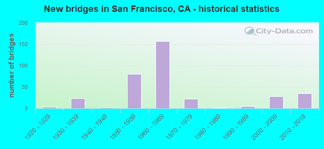
- New bridges - historical statistics
- 11900-1909
- 11910-1919
- 31920-1929
- 231930-1939
- 21940-1949
- 801950-1959
- 1571960-1969
- 221970-1979
- 11980-1989
- 51990-1999
- 282000-2009
- 352010-2019
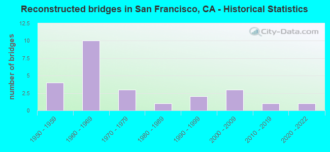
- Reconstructed bridges - Historical Statistics
- 41950-1959
- 101960-1969
- 31970-1979
- 11980-1989
- 21990-1999
- 32000-2009
- 12010-2019
- 12020-2022
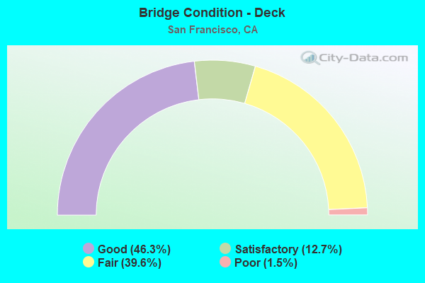
- Bridge Condition - Deck
- 46.3%Good
- 12.7%Satisfactory
- 39.6%Fair
- 1.5%Poor
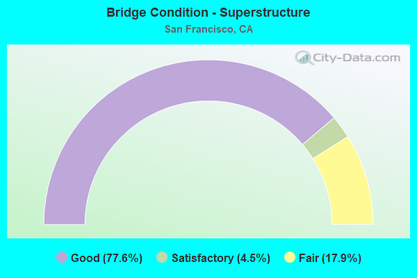
- Bridge Condition - Superstructure
- 77.6%Good
- 4.5%Satisfactory
- 17.9%Fair
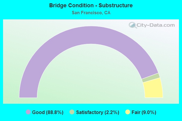
- Bridge Condition - Substructure
- 88.8%Good
- 2.2%Satisfactory
- 9.0%Fair
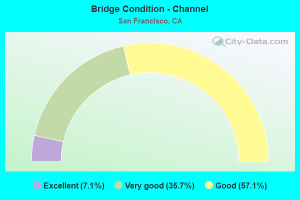
- Bridge Condition - Channel
- 7.1%Excellent
- 35.7%Very good
- 57.1%Good
Find on map >> Show street view
Structure Number: 34 0071F, Location: 04-SF-101-1.94-SF (Lat: 37.734861, Lng: -122.409717), Route carried "under" structure: Ramp State highway 101, Year Built: 1960, Structure Length: 0. m, Average Daily Traffic: 450 (year 2018), Truck Traffic: 2%, Features Intersected: 280/101 IC -ALEMANY BLVD
Minimum Vertical Clearance: 4.98m (16.34ft), Kilometerpoint: 1.940, Lanes on structure: 2, Lanes under structure: 1, Material/Design: Concrete continuous, Design/Construction: Box Beam or Girders - Multiple, Length of Maximum Span: 30.5m (100.1ft)
Find on map >> Show street view
Structure Number: 34 0071F, Location: 04-SF-101-1.94-SF (Lat: 37.734861, Lng: -122.409717), Route carried "under" structure: City street D014, Year Built: 1960, Structure Length: 0. m, Average Daily Traffic: 2,500 (year 2018), Truck Traffic: 3%, Features Intersected: 280/101 IC -ALEMANY BLVD, Facility Carried by Structure: S101-S280 CONNECTO
Minimum Vertical Clearance: 6.71m (22.01ft), Kilometerpoint: 0.000, Lanes on structure: 2, Lanes under structure: 8, Material/Design: Concrete continuous, Design/Construction: Box Beam or Girders - Multiple, Length of Maximum Span: 30.5m (100.1ft)
Find on map >> Show street view
Structure Number: 34 0073, Location: 04-SF-280-R3.87-SF (Lat: 37.731919, Lng: -122.414628), Route carried "under" structure: Interstate 280, Year Built: 1963, Structure Length: 0. m, Average Daily Traffic: 170,000 (year 2019), Truck Traffic: 1%, Features Intersected: ROUTE I 280, Facility Carried by Structure: ALEMANY BLVD NB
Minimum Vertical Clearance: 4.90m (16.08ft), Kilometerpoint: 3.870, Lanes on structure: 2, Lanes under structure: 10, Material/Design: Concrete continuous, Design/Construction: Box Beam or Girders - Multiple, Length of Maximum Span: 38.7m (127.0ft)
Find on map >> Show street view
Structure Number: 34 0074, Location: 04-SF-280-R3.28-SF (Lat: 37.731261, Lng: -122.425347), Route carried "under" structure: Interstate 280, Year Built: 1963, Structure Length: 0. m, Average Daily Traffic: 170,000 (year 2017), Truck Traffic: 1%, Features Intersected: ROUTE I 280, Facility Carried by Structure: ALEMANY BLVD SB
Minimum Vertical Clearance: 4.87m (15.98ft), Kilometerpoint: 3.280, Lanes on structure: 2, Lanes under structure: 8, Material/Design: Concrete continuous, Design/Construction: Box Beam or Girders - Multiple, Length of Maximum Span: 44.2m (145.0ft)
Find on map >> Show street view
Structure Number: 34 0075, Location: 04-SF-280-R3.23-SF (Lat: 37.731789, Lng: -122.426097), Route carried "under" structure: Interstate 280, Year Built: 1963, Structure Length: 0. m, Average Daily Traffic: 170,000 (year 2019), Truck Traffic: 1%, Features Intersected: ROUTE I 280, Facility Carried by Structure: JUSTIN DRIVE
Minimum Vertical Clearance: 4.85m (15.91ft), Kilometerpoint: 3.230, Lanes on structure: 3, Lanes under structure: 8, Material/Design: Concrete continuous, Design/Construction: Box Beam or Girders - Multiple, Length of Maximum Span: 27.7m (90.9ft)
Find on map >> Show street view
Structure Number: 34 0076, Location: 04-SF-280-R3.53-SF (Lat: 37.732400, Lng: -122.420878), Route carried "under" structure: Interstate 280, Year Built: 1963, Structure Length: 0. m, Average Daily Traffic: 170,000 (year 2009), Truck Traffic: 1%, Features Intersected: INTERSTATE 280, Facility Carried by Structure: PEDESTRIAN WALKWAY
Minimum Vertical Clearance: 4.62m (15.16ft), Kilometerpoint: 3.530, Lanes under structure: 14, Material/Design: Concrete continuous, Design/Construction: Box Beam or Girders - Multiple, Length of Maximum Span: 26.5m (86.9ft)
Find on map >> Show street view
Structure Number: 34 0077, Location: 04-SF-101-R4.25L-SF (Lat: 37.769892, Lng: -122.418478), Route carried "under" structure: Ramp US 101, Year Built: 1955, Structure Length: 0. m, Average Daily Traffic: 84,000 (year 2019), Truck Traffic: 3%, Features Intersected: I-80 & US 101 RAMPS,STRS
Minimum Vertical Clearance: 4.72m (15.49ft), Kilometerpoint: 4.250, Lanes on structure: 4, Lanes under structure: 3, Material/Design: Steel, Design/Construction: Stringer/Multi-beam, Length of Maximum Span: 32.2m (105.6ft)
Find on map >> Show street view
Structure Number: 34 0077, Location: 04-SF-101-R4.25L-SF (Lat: 37.769892, Lng: -122.418478), Route carried "under" structure: Ramp US 101, Year Built: 1955, Structure Length: 0. m, Average Daily Traffic: 84,000 (year 2019), Truck Traffic: 3%, Features Intersected: I-80 & US 101 RAMPS,STRS
Minimum Vertical Clearance: 5.59m (18.34ft), Kilometerpoint: 4.250, Lanes on structure: 4, Lanes under structure: 2, Material/Design: Steel, Design/Construction: Stringer/Multi-beam, Length of Maximum Span: 32.2m (105.6ft)
Find on map >> Show street view
Structure Number: 34 0077, Location: 04-SF-101-R4.25L-SF (Lat: 37.769892, Lng: -122.418478), Route carried "under" structure: Ramp US 101, Year Built: 1955, Structure Length: 0. m, Average Daily Traffic: 2,000 (year 2019), Truck Traffic: 1%, Features Intersected: I-80 & US 101 RAMPS,STRS
Minimum Vertical Clearance: 4.75m (15.58ft), Kilometerpoint: 4.250, Lanes on structure: 4, Lanes under structure: 2, Material/Design: Steel, Design/Construction: Stringer/Multi-beam, Length of Maximum Span: 32.2m (105.6ft)
Find on map >> Show street view
Structure Number: 34 0077, Location: 04-SF-101-R4.25L-SF (Lat: 37.769892, Lng: -122.418478), Route carried "under" structure: City street , Year Built: 1955, Structure Length: 0. m, Average Daily Traffic: 4,000 (year 2019), Truck Traffic: 1%, Features Intersected: I-80 & US 101 RAMPS,STRS, Facility Carried by Structure: U.S. HIGHWAY 101
Minimum Vertical Clearance: 7.62m (25.00ft), Kilometerpoint: 0.000, Lanes on structure: 4, Lanes under structure: 4, Material/Design: Steel, Design/Construction: Stringer/Multi-beam, Length of Maximum Span: 32.2m (105.6ft)
Find on map >> Show street view
Structure Number: 34 0077, Location: 04-SF-101-R4.25L-SF (Lat: 37.769892, Lng: -122.418478), Route carried "under" structure: City street , Year Built: 1955, Structure Length: 0. m, Average Daily Traffic: 6,000 (year 2019), Truck Traffic: 1%, Features Intersected: I-80 & US 101 RAMPS,STRS, Facility Carried by Structure: U.S. HIGHWAY 101
Minimum Vertical Clearance: 4.88m (16.01ft), Kilometerpoint: 0.000, Lanes on structure: 4, Lanes under structure: 5, Material/Design: Steel, Design/Construction: Stringer/Multi-beam, Length of Maximum Span: 32.2m (105.6ft)
Find on map >> Show street view
Structure Number: 34 0077, Location: 04-SF-101-R4.25L-SF (Lat: 37.769892, Lng: -122.418478), Route carried "under" structure: City street , Year Built: 1955, Structure Length: 0. m, Average Daily Traffic: 4,000 (year 2019), Truck Traffic: 1%, Features Intersected: I-80 & US 101 RAMPS,STRS, Facility Carried by Structure: U.S. HIGHWAY 101
Minimum Vertical Clearance: 7.62m (25.00ft), Kilometerpoint: 0.000, Lanes on structure: 4, Lanes under structure: 4, Material/Design: Steel, Design/Construction: Stringer/Multi-beam, Length of Maximum Span: 32.2m (105.6ft)
Find on map >> Show street view
Structure Number: 34 0077, Location: 04-SF-101-R4.25L-SF (Lat: 37.769892, Lng: -122.418478), Route carried "under" structure: City street , Year Built: 1955, Structure Length: 0. m, Average Daily Traffic: 3,500 (year 2019), Truck Traffic: 1%, Features Intersected: I-80 & US 101 RAMPS,STRS, Facility Carried by Structure: U.S. HIGHWAY 101
Minimum Vertical Clearance: 5.79m (19.00ft), Kilometerpoint: 0.000, Lanes on structure: 4, Lanes under structure: 4, Material/Design: Steel, Design/Construction: Stringer/Multi-beam, Length of Maximum Span: 32.2m (105.6ft)
Find on map >> Show street view
Structure Number: 34 0077, Location: 04-SF-101-R4.25L-SF (Lat: 37.769892, Lng: -122.418478), Route carried "under" structure: Ramp Interstate 80, Year Built: 1955, Structure Length: 0. m, Average Daily Traffic: 199,000 (year 2019), Truck Traffic: 5%, Features Intersected: I-80 & US 101 RAMPS,STRS, Facility Carried by Structure: U.S. HIGHWAY 101
Minimum Vertical Clearance: 4.71m (15.45ft), Kilometerpoint: 5.450, Lanes on structure: 4, Lanes under structure: 3, Material/Design: Steel, Design/Construction: Stringer/Multi-beam, Length of Maximum Span: 32.2m (105.6ft)
Find on map >> Show street view
Structure Number: 34 0077, Location: 04-SF-101-R4.25L-SF (Lat: 37.769892, Lng: -122.418478), Route carried "under" structure: Interstate 80, Year Built: 1955, Structure Length: 0. m, Average Daily Traffic: 84,000 (year 2019), Truck Traffic: 3%, Features Intersected: I-80 & US 101 RAMPS,STRS, Facility Carried by Structure: U.S. HIGHWAY 101
Minimum Vertical Clearance: 4.67m (15.32ft), Kilometerpoint: 5.450, Lanes on structure: 4, Lanes under structure: 3, Material/Design: Steel, Design/Construction: Stringer/Multi-beam, Length of Maximum Span: 32.2m (105.6ft)
Find on map >> Show street view
Structure Number: 34 0077, Location: 04-SF-101-R4.25L-SF (Lat: 37.769892, Lng: -122.418478), Route carried "under" structure: Ramp US 101, Year Built: 1955, Structure Length: 0. m, Average Daily Traffic: 2,000 (year 2019), Truck Traffic: 1%, Features Intersected: I-80 & US 101 RAMPS,STRS
Minimum Vertical Clearance: 5.00m (16.40ft), Kilometerpoint: 4.250, Lanes on structure: 4, Lanes under structure: 2, Material/Design: Steel, Design/Construction: Stringer/Multi-beam, Length of Maximum Span: 32.2m (105.6ft)
Find on map >> Show street view
Structure Number: 34 0077, Location: 04-SF-101-R4.25L-SF (Lat: 37.769892, Lng: -122.418478), Route carried "under" structure: Ramp Interstate 80, Year Built: 1955, Structure Length: 0. m, Average Daily Traffic: 199,000 (year 2019), Truck Traffic: 5%, Features Intersected: I-80 & US 101 RAMPS,STRS, Facility Carried by Structure: U.S. HIGHWAY 101
Minimum Vertical Clearance: 4.72m (15.49ft), Kilometerpoint: 5.450, Lanes on structure: 4, Lanes under structure: 6, Material/Design: Steel, Design/Construction: Stringer/Multi-beam, Length of Maximum Span: 32.2m (105.6ft)
Find on map >> Show street view
Structure Number: 34 0077, Location: 04-SF-101-R4.25L-SF (Lat: 37.769892, Lng: -122.418478), Route carried "under" structure: City street , Year Built: 1955, Structure Length: 0. m, Average Daily Traffic: 35,001 (year 2019), Truck Traffic: 1%, Features Intersected: I-80 & US 101 RAMPS,STRS, Facility Carried by Structure: U.S. HIGHWAY 101
Minimum Vertical Clearance: 7.55m (24.77ft), Kilometerpoint: 0.000, Lanes on structure: 4, Lanes under structure: 4, Material/Design: Steel, Design/Construction: Stringer/Multi-beam, Length of Maximum Span: 32.2m (105.6ft)
Find on map >> Show street view
Structure Number: 34 0077, Location: 04-SF-101-R4.25L-SF (Lat: 37.769892, Lng: -122.418478), Route carried "under" structure: City street , Year Built: 1955, Structure Length: 0. m, Average Daily Traffic: 3,500 (year 2019), Truck Traffic: 1%, Features Intersected: I-80 & US 101 RAMPS,STRS, Facility Carried by Structure: U.S. HIGHWAY 101
Minimum Vertical Clearance: 7.62m (25.00ft), Kilometerpoint: 0.000, Lanes on structure: 4, Lanes under structure: 4, Material/Design: Steel, Design/Construction: Stringer/Multi-beam, Length of Maximum Span: 32.2m (105.6ft)
Find on map >> Show street view
Structure Number: 34 0077, Location: 04-SF-101-R4.25L-SF (Lat: 37.769892, Lng: -122.418478), Route carried "under" structure: City street , Year Built: 1955, Structure Length: 0. m, Average Daily Traffic: 3,500 (year 2019), Truck Traffic: 1%, Features Intersected: I-80 & US 101 RAMPS,STRS, Facility Carried by Structure: U.S. HIGHWAY 101
Minimum Vertical Clearance: 5.23m (17.16ft), Kilometerpoint: 0.000, Lanes on structure: 4, Lanes under structure: 4, Material/Design: Steel, Design/Construction: Stringer/Multi-beam, Length of Maximum Span: 32.2m (105.6ft)
Find on map >> Show street view
Structure Number: 34 0077, Location: 04-SF-101-R4.25L-SF (Lat: 37.769892, Lng: -122.418478), Route carried "under" structure: City street , Year Built: 1955, Structure Length: 0. m, Average Daily Traffic: 3,500 (year 2019), Truck Traffic: 1%, Features Intersected: I-80 & US 101 RAMPS,STRS, Facility Carried by Structure: U.S. HIGHWAY 101
Minimum Vertical Clearance: 5.26m (17.26ft), Kilometerpoint: 0.000, Lanes on structure: 4, Lanes under structure: 4, Material/Design: Steel, Design/Construction: Stringer/Multi-beam, Length of Maximum Span: 32.2m (105.6ft)
Find on map >> Show street view
Structure Number: 34 0077, Location: 04-SF-101-R4.25L-SF (Lat: 37.769892, Lng: -122.418478), Route carried "under" structure: City street , Year Built: 1955, Structure Length: 0. m, Average Daily Traffic: 3,500 (year 2019), Truck Traffic: 1%, Features Intersected: I-80 & US 101 RAMPS,STRS, Facility Carried by Structure: U.S. HIGHWAY 101
Minimum Vertical Clearance: 11.60m (38.06ft), Kilometerpoint: 0.000, Lanes on structure: 4, Lanes under structure: 4, Material/Design: Steel, Design/Construction: Stringer/Multi-beam, Length of Maximum Span: 32.2m (105.6ft)
Find on map >> Show street view
Structure Number: 34 0077, Location: 04-SF-101-R4.25L-SF (Lat: 37.769892, Lng: -122.418478), Route carried "under" structure: City street , Year Built: 1955, Structure Length: 0. m, Average Daily Traffic: 4,000 (year 2019), Truck Traffic: 1%, Features Intersected: I-80 & US 101 RAMPS,STRS, Facility Carried by Structure: U.S. HIGHWAY 101
Minimum Vertical Clearance: 5.23m (17.16ft), Kilometerpoint: 0.000, Lanes on structure: 4, Lanes under structure: 4, Material/Design: Steel, Design/Construction: Stringer/Multi-beam, Length of Maximum Span: 32.2m (105.6ft)
Find on map >> Show street view
Structure Number: 34 0077, Location: 04-SF-101-R4.25L-SF (Lat: 37.769892, Lng: -122.418478), Route carried "under" structure: City street , Year Built: 1955, Structure Length: 0. m, Average Daily Traffic: 6,000 (year 2019), Truck Traffic: 2%, Features Intersected: I-80 & US 101 RAMPS,STRS, Facility Carried by Structure: U.S. HIGHWAY 101
Minimum Vertical Clearance: 4.75m (15.58ft), Kilometerpoint: 0.000, Lanes on structure: 4, Lanes under structure: 4, Material/Design: Steel, Design/Construction: Stringer/Multi-beam, Length of Maximum Span: 32.2m (105.6ft)
Find on map >> Show street view
Structure Number: 34 0077, Location: 04-SF-101-R4.25L-SF (Lat: 37.769892, Lng: -122.418478), Route carried "under" structure: City street , Year Built: 1955, Structure Length: 0. m, Average Daily Traffic: 5,000 (year 2019), Truck Traffic: 1%, Features Intersected: I-80 & US 101 RAMPS,STRS, Facility Carried by Structure: U.S. HIGHWAY 101
Minimum Vertical Clearance: 4.58m (15.03ft), Kilometerpoint: 0.000, Lanes on structure: 4, Lanes under structure: 6, Material/Design: Steel, Design/Construction: Stringer/Multi-beam, Length of Maximum Span: 32.2m (105.6ft)
Find on map >> Show street view
Structure Number: 34 0078, Location: 04-SF-280-R2.62-SF (Lat: 37.731322, Lng: -122.436961), Route carried "under" structure: Interstate 280, Year Built: 1964, Structure Length: 0. m, Average Daily Traffic: 170,000 (year 2009), Truck Traffic: 1%, Features Intersected: RTE I 280S ONRAMP, Facility Carried by Structure: THERESA ST POC
Minimum Vertical Clearance: 5.15m (16.90ft), Kilometerpoint: 2.620, Lanes under structure: 8, Material/Design: Concrete continuous, Design/Construction: Box Beam or Girders - Multiple, Length of Maximum Span: 25.9m (85.0ft)
Find on map >> Show street view
Structure Number: 34 0078, Location: 04-SF-280-R2.62-SF (Lat: 37.731322, Lng: -122.436961), Route carried "under" structure: Ramp Interstate 280, Year Built: 1964, Structure Length: 0. m, Average Daily Traffic: 10,300 (year 2010), Truck Traffic: 2%, Features Intersected: RTE I 280S ONRAMP, Facility Carried by Structure: THERESA ST POC
Minimum Vertical Clearance: 5.84m (19.16ft), Kilometerpoint: 2.820, Lanes under structure: 2, Material/Design: Concrete continuous, Design/Construction: Box Beam or Girders - Multiple, Length of Maximum Span: 25.9m (85.0ft)
Find on map >> Show street view
Structure Number: 34 0078, Location: 04-SF-280-R2.62-SF (Lat: 37.731322, Lng: -122.436961), Route carried "under" structure: Interstate 280, Year Built: 1964, Structure Length: 0. m, Average Daily Traffic: 170,000 (year 2009), Truck Traffic: 1%, Features Intersected: RTE I 280S ONRAMP, Facility Carried by Structure: THERESA ST POC
Minimum Vertical Clearance: 5.79m (19.00ft), Kilometerpoint: 2.620, Lanes under structure: 2, Material/Design: Concrete continuous, Design/Construction: Box Beam or Girders - Multiple, Length of Maximum Span: 25.9m (85.0ft)
Find on map >> Show street view
Structure Number: 34 0078, Location: 04-SF-280-R2.62-SF (Lat: 37.731322, Lng: -122.436961), Route carried "under" structure: Business City street D012, Year Built: 1964, Structure Length: 0. m, Average Daily Traffic: 20,000 (year 2010), Truck Traffic: 2%, Features Intersected: RTE I 280S ONRAMP, Facility Carried by Structure: THERESA ST POC
Minimum Vertical Clearance: 4.85m (15.91ft), Kilometerpoint: 0.000, Lanes under structure: 3, Material/Design: Concrete continuous, Design/Construction: Box Beam or Girders - Multiple, Length of Maximum Span: 25.9m (85.0ft)
Find on map >> Show street view
Structure Number: 34 0079K, Location: 04-SF-280-R2.72-SF (Lat: 37.731550, Lng: -122.436367), Route carried "under" structure: Ramp Interstate 280, Year Built: 1964, Structure Length: 0. m, Average Daily Traffic: 10,000 (year 2017), Truck Traffic: 5%, Features Intersected: I 280,SAN JOSE,MUNI,BART
Minimum Vertical Clearance: 5.79m (19.00ft), Kilometerpoint: 2.720, Lanes on structure: 2, Lanes under structure: 2, Material/Design: Concrete continuous, Design/Construction: Box Beam or Girders - Multiple, Length of Maximum Span: 42.1m (138.1ft)
Find on map >> Show street view
Structure Number: 34 0079K, Location: 04-SF-280-R2.72-SF (Lat: 37.731550, Lng: -122.436367), Route carried "under" structure: Ramp Interstate 280, Year Built: 1964, Structure Length: 0. m, Average Daily Traffic: 10,000 (year 2017), Truck Traffic: 5%, Features Intersected: I 280,SAN JOSE,MUNI,BART
Minimum Vertical Clearance: 5.79m (19.00ft), Kilometerpoint: 2.720, Lanes on structure: 2, Lanes under structure: 1, Material/Design: Concrete continuous, Design/Construction: Box Beam or Girders - Multiple, Length of Maximum Span: 42.1m (138.1ft)
Find on map >> Show street view
Structure Number: 34 0079K, Location: 04-SF-280-R2.72-SF (Lat: 37.731550, Lng: -122.436367), Route carried "under" structure: City street D012, Year Built: 1964, Structure Length: 0. m, Average Daily Traffic: 21,600 (year 2017), Truck Traffic: 2%, Features Intersected: I 280,SAN JOSE,MUNI,BART, Facility Carried by Structure: I280S OFF-MONTEREY
Minimum Vertical Clearance: 5.79m (19.00ft), Kilometerpoint: 0.000, Lanes on structure: 2, Lanes under structure: 2, Material/Design: Concrete continuous, Design/Construction: Box Beam or Girders - Multiple, Length of Maximum Span: 42.1m (138.1ft)
Find on map >> Show street view
Structure Number: 34 0079K, Location: 04-SF-280-R2.72-SF (Lat: 37.731550, Lng: -122.436367), Route carried "under" structure: Ramp Interstate 280, Year Built: 1964, Structure Length: 0. m, Average Daily Traffic: 23,200 (year 2017), Truck Traffic: 2%, Features Intersected: I 280,SAN JOSE,MUNI,BART
Minimum Vertical Clearance: 9.14m (29.99ft), Kilometerpoint: 2.720, Lanes on structure: 2, Lanes under structure: 8, Material/Design: Concrete continuous, Design/Construction: Box Beam or Girders - Multiple, Length of Maximum Span: 42.1m (138.1ft)
Find on map >> Show street view
Structure Number: 34 0079L, Location: 04-SF-280-R2.70-SF (Lat: 37.731322, Lng: -122.435497), Route carried "under" structure: Other road , Year Built: 1964, Structure Length: 0. m, Average Daily Traffic: 10,000 (year 2017), Truck Traffic: 5%, Features Intersected: SAN JOSE AVE, MUNIRAIL, Facility Carried by Structure: ROUTE I 280 SB
Minimum Vertical Clearance: 4.87m (15.98ft), Kilometerpoint: 0.000, Lanes on structure: 4, Lanes under structure: 2, Material/Design: Concrete, Design/Construction: Box Beam or Girders - Multiple, Length of Maximum Span: 20.7m (67.9ft)
Find on map >> Show street view
Structure Number: 34 0079L, Location: 04-SF-280-R2.70-SF (Lat: 37.731322, Lng: -122.435497), Route carried "under" structure: Business City street D012, Year Built: 1964, Structure Length: 0. m, Average Daily Traffic: 5,000 (year 2017), Truck Traffic: 5%, Features Intersected: SAN JOSE AVE, MUNIRAIL, Facility Carried by Structure: ROUTE I 280 SB
Minimum Vertical Clearance: 4.87m (15.98ft), Kilometerpoint: 0.000, Lanes on structure: 4, Lanes under structure: 4, Material/Design: Concrete, Design/Construction: Box Beam or Girders - Multiple, Length of Maximum Span: 20.7m (67.9ft)
Find on map >> Show street view
Structure Number: 34 0079R, Location: 04-SF-280-R2.70-SF (Lat: 37.731067, Lng: -122.435700), Route carried "under" structure: Other road , Year Built: 1964, Structure Length: 0. m, Average Daily Traffic: 10,000 (year 2016), Truck Traffic: 5%, Features Intersected: SAN JOSE AVE, MUNIRAIL, Facility Carried by Structure: ROUTE I 280
Minimum Vertical Clearance: 4.90m (16.08ft), Kilometerpoint: 0.000, Lanes on structure: 4, Lanes under structure: 2, Material/Design: Concrete, Design/Construction: Box Beam or Girders - Multiple, Length of Maximum Span: 20.7m (67.9ft)
Find on map >> Show street view
Structure Number: 34 0079R, Location: 04-SF-280-R2.70-SF (Lat: 37.731067, Lng: -122.435700), Route carried "under" structure: Business City street D012, Year Built: 1964, Structure Length: 0. m, Average Daily Traffic: 10,000 (year 2016), Truck Traffic: 5%, Features Intersected: SAN JOSE AVE, MUNIRAIL, Facility Carried by Structure: ROUTE I 280
Minimum Vertical Clearance: 4.90m (16.08ft), Kilometerpoint: 0.000, Lanes on structure: 4, Lanes under structure: 4, Material/Design: Concrete, Design/Construction: Box Beam or Girders - Multiple, Length of Maximum Span: 20.7m (67.9ft)
Find on map >> Show street view
Structure Number: 34 0079S, Location: 04-SF-280-R2.69-SF (Lat: 37.730853, Lng: -122.435778), Route carried "under" structure: Business City street D012, Year Built: 1964, Structure Length: 0. m, Average Daily Traffic: 10,000 (year 2017), Truck Traffic: 5%, Features Intersected: SAN JOSE AVE, MUNIRAIL, Facility Carried by Structure: RTE I 280N OFFRAMP
Minimum Vertical Clearance: 4.94m (16.21ft), Kilometerpoint: 0.000, Lanes on structure: 2, Lanes under structure: 1, Material/Design: Concrete, Design/Construction: Box Beam or Girders - Multiple, Length of Maximum Span: 35.1m (115.2ft)
Find on map >> Show street view
Structure Number: 34 0079S, Location: 04-SF-280-R2.69-SF (Lat: 37.730853, Lng: -122.435778), Route carried "under" structure: Business City street D012, Year Built: 1964, Structure Length: 0. m, Average Daily Traffic: 10,000 (year 2017), Truck Traffic: 2%, Features Intersected: SAN JOSE AVE, MUNIRAIL, Facility Carried by Structure: RTE I 280N OFFRAMP
Minimum Vertical Clearance: 4.96m (16.27ft), Kilometerpoint: 0.000, Lanes on structure: 2, Lanes under structure: 1, Material/Design: Concrete, Design/Construction: Box Beam or Girders - Multiple, Length of Maximum Span: 35.1m (115.2ft)
Find on map >> Show street view
Structure Number: 34 0079S, Location: 04-SF-280-R2.69-SF (Lat: 37.730853, Lng: -122.435778), Route carried "under" structure: Other road , Year Built: 1964, Structure Length: 0. m, Average Daily Traffic: 10,000 (year 2017), Truck Traffic: 95%, Features Intersected: SAN JOSE AVE, MUNIRAIL, Facility Carried by Structure: RTE I 280N OFFRAMP
Minimum Vertical Clearance: 4.77m (15.65ft), Kilometerpoint: 0.000, Lanes on structure: 2, Lanes under structure: 2, Material/Design: Concrete, Design/Construction: Box Beam or Girders - Multiple, Length of Maximum Span: 35.1m (115.2ft)
Find on map >> Show street view
Structure Number: 34 0081, Location: 04-SF-280-R2.69-SF (Lat: 37.731469, Lng: -122.436519), Route carried "under" structure: Interstate 280, Year Built: 1964, Structure Length: 0. m, Average Daily Traffic: 170,000 (year 2019), Truck Traffic: 1%, Features Intersected: I 280,SAN JOSE,MUNI,BART
Minimum Vertical Clearance: 5.15m (16.90ft), Kilometerpoint: 2.690, Lanes on structure: 1, Lanes under structure: 8, Material/Design: Concrete continuous, Design/Construction: Box Beam or Girders - Multiple, Length of Maximum Span: 41.8m (137.1ft)
Find on map >> Show street view
Structure Number: 34 0081, Location: 04-SF-280-R2.69-SF (Lat: 37.731469, Lng: -122.436519), Route carried "under" structure: Business City street D012, Year Built: 1964, Structure Length: 0. m, Average Daily Traffic: 21,600 (year 2019), Truck Traffic: 2%, Features Intersected: I 280,SAN JOSE,MUNI,BART, Facility Carried by Structure: MONTEREY-I 280N ON
Minimum Vertical Clearance: 5.79m (19.00ft), Kilometerpoint: 0.000, Lanes on structure: 1, Lanes under structure: 2, Material/Design: Concrete continuous, Design/Construction: Box Beam or Girders - Multiple, Length of Maximum Span: 41.8m (137.1ft)
Find on map >> Show street view
Structure Number: 34 0081, Location: 04-SF-280-R2.69-SF (Lat: 37.731469, Lng: -122.436519), Route carried "under" structure: Ramp City street D012, Year Built: 1964, Structure Length: 0. m, Average Daily Traffic: 10,000 (year 2019), Truck Traffic: 5%, Features Intersected: I 280,SAN JOSE,MUNI,BART, Facility Carried by Structure: MONTEREY-I 280N ON
Minimum Vertical Clearance: 5.79m (19.00ft), Kilometerpoint: 0.000, Lanes on structure: 1, Lanes under structure: 2, Material/Design: Concrete continuous, Design/Construction: Box Beam or Girders - Multiple, Length of Maximum Span: 41.8m (137.1ft)
Find on map >> Show street view
Structure Number: 34 0081, Location: 04-SF-280-R2.69-SF (Lat: 37.731469, Lng: -122.436519), Route carried "under" structure: Ramp City street D012, Year Built: 1964, Structure Length: 0. m, Average Daily Traffic: 10,000 (year 2019), Truck Traffic: 5%, Features Intersected: I 280,SAN JOSE,MUNI,BART, Facility Carried by Structure: MONTEREY-I 280N ON
Minimum Vertical Clearance: 5.79m (19.00ft), Kilometerpoint: 0.000, Lanes on structure: 1, Lanes under structure: 1, Material/Design: Concrete continuous, Design/Construction: Box Beam or Girders - Multiple, Length of Maximum Span: 41.8m (137.1ft)
Find on map >> Show street view
Structure Number: 34 0082, Location: 04-SF-280-R2.21-SF (Lat: 37.728239, Lng: -122.444028), Route carried "under" structure: Interstate 280, Year Built: 1964, Structure Length: 0. m, Average Daily Traffic: 170,000 (year 2017), Truck Traffic: 1%, Features Intersected: RTE I 280, BART-2 TRACKS, Facility Carried by Structure: PAULDING/JUDSON ST
Minimum Vertical Clearance: 4.74m (15.55ft), Kilometerpoint: 2.210, Lanes on structure: 2, Lanes under structure: 9, Material/Design: Concrete continuous, Design/Construction: Box Beam or Girders - Multiple, Length of Maximum Span: 34.7m (113.8ft)
Find on map >> Show street view
Structure Number: 34 0083, Location: 04-SF-280-R2.47-SF (Lat: 37.730222, Lng: -122.439747), Route carried "under" structure: Interstate 280, Year Built: 1964, Structure Length: 0. m, Average Daily Traffic: 170,000 (year 2019), Truck Traffic: 1%, Features Intersected: RTE I 280, BART TUNNELS, Facility Carried by Structure: BADEN STREET
Minimum Vertical Clearance: 4.57m (14.99ft), Kilometerpoint: 2.470, Lanes on structure: 2, Lanes under structure: 9, Material/Design: Concrete continuous, Design/Construction: Box Beam or Girders - Multiple, Length of Maximum Span: 30.2m (99.1ft)
Find on map >> Show street view
Structure Number: 34 0085, Location: 04-SF-280-R0.71-SF (Lat: 37.710433, Lng: -122.457075), Route carried "under" structure: Business State highway 82, Year Built: 1964, Structure Length: 0. m, Average Daily Traffic: 21,600 (year 2017), Truck Traffic: 2%, Features Intersected: SAN JOSE & SICKLES AVE, Facility Carried by Structure: I 280
Minimum Vertical Clearance: 4.90m (16.08ft), Kilometerpoint: 0.200, Lanes on structure: 8, Lanes under structure: 6, Material/Design: Concrete continuous, Design/Construction: Box Beam or Girders - Multiple, Length of Maximum Span: 29.4m (96.5ft)
Find on map >> Show street view
Structure Number: 34 0085, Location: 04-SF-280-R0.71-SF (Lat: 37.710433, Lng: -122.457075), Route carried "under" structure: Business City street D041, Year Built: 1964, Structure Length: 0. m, Average Daily Traffic: 10,000 (year 2017), Truck Traffic: 2%, Features Intersected: SAN JOSE & SICKLES AVE, Facility Carried by Structure: I 280
Minimum Vertical Clearance: 4.95m (16.24ft), Kilometerpoint: 0.000, Lanes on structure: 8, Lanes under structure: 4, Material/Design: Concrete continuous, Design/Construction: Box Beam or Girders - Multiple, Length of Maximum Span: 29.4m (96.5ft)
Find on map >> Show street view
Structure Number: 34 0085S, Location: 04-SF-280-R0.75-SF (Lat: 37.710694, Lng: -122.455464), Route carried "under" structure: Business City street D041, Year Built: 1964, Structure Length: 0. m, Average Daily Traffic: 10,000 (year 2010), Truck Traffic: 2%, Features Intersected: SICKLES AVENUE, Facility Carried by Structure: RTE I 280 N ONRAMP
Minimum Vertical Clearance: 4.95m (16.24ft), Kilometerpoint: 0.000, Lanes on structure: 1, Lanes under structure: 4, Material/Design: Concrete continuous, Design/Construction: Box Beam or Girders - Multiple, Length of Maximum Span: 25.3m (83.0ft)
Find on map >> Show street view
Structure Number: 34 0086, Location: 04-SF-280-R0.90-SF (Lat: 37.712369, Lng: -122.453983), Route carried "under" structure: Ramp Interstate 280, Year Built: 1964, Structure Length: 0. m, Average Daily Traffic: 13,300 (year 2010), Truck Traffic: 2%, Features Intersected: SB 280 OFF-RAMP, Facility Carried by Structure: SAN JOSE AVE
Minimum Vertical Clearance: 4.62m (15.16ft), Kilometerpoint: 0.900, Lanes on structure: 1, Lanes under structure: 2, Material/Design: Concrete continuous, Design/Construction: Box Beam or Girders - Multiple, Length of Maximum Span: 16.2m (53.1ft)
Find on map >> Show street view
Structure Number: 34 0087, Location: 04-SF-280-R1.46-SF (Lat: 37.718144, Lng: -122.448800), Route carried "under" structure: Interstate 280, Year Built: 1964, Structure Length: 0. m, Average Daily Traffic: 166,000 (year 2017), Truck Traffic: 1%, Features Intersected: ROUTE I 280, Facility Carried by Structure: SAN JOSE, MUNIRAIL
Minimum Vertical Clearance: 5.38m (17.65ft), Kilometerpoint: 1.460, Lanes on structure: 4, Lanes under structure: 9, Material/Design: Concrete continuous, Design/Construction: Box Beam or Girders - Multiple, Length of Maximum Span: 34.7m (113.8ft)
Find on map >> Show street view
Structure Number: 34 0088, Location: 04-SF-101-4.12-SF (Lat: 37.764311, Lng: -122.404817), Route carried "under" structure: City street D206, Year Built: 1955, Structure Length: 0. m, Average Daily Traffic: 3,650 (year 2019), Truck Traffic: 2%, Features Intersected: BAYSHORE VIADUCT, Facility Carried by Structure: ST RTE 101 (5TH ST
Minimum Vertical Clearance: 4.34m (14.24ft), Kilometerpoint: 0.000, Lanes on structure: 6, Lanes under structure: 5, Material/Design: Steel, Design/Construction: Stringer/Multi-beam, Length of Maximum Span: 36.0m (118.1ft)
Find on map >> Show street view
Structure Number: 34 0088, Location: 04-SF-101-4.12-SF (Lat: 37.764311, Lng: -122.404817), Route carried "under" structure: City street D183, Year Built: 1955, Structure Length: 0. m, Average Daily Traffic: 3,100 (year 2019), Truck Traffic: 2%, Features Intersected: BAYSHORE VIADUCT, Facility Carried by Structure: ST RTE 101 (5TH ST
Minimum Vertical Clearance: 4.67m (15.32ft), Kilometerpoint: 0.000, Lanes on structure: 6, Lanes under structure: 5, Material/Design: Steel, Design/Construction: Stringer/Multi-beam, Length of Maximum Span: 36.0m (118.1ft)
Find on map >> Show street view
Structure Number: 34 0088, Location: 04-SF-101-4.12-SF (Lat: 37.764311, Lng: -122.404817), Route carried "under" structure: City street D020, Year Built: 1955, Structure Length: 0. m, Average Daily Traffic: 3,100 (year 2019), Truck Traffic: 2%, Features Intersected: BAYSHORE VIADUCT, Facility Carried by Structure: ST RTE 101 (5TH ST
Minimum Vertical Clearance: 4.21m (13.81ft), Kilometerpoint: 0.000, Lanes on structure: 6, Lanes under structure: 4, Material/Design: Steel, Design/Construction: Stringer/Multi-beam, Length of Maximum Span: 36.0m (118.1ft)
Find on map >> Show street view
Structure Number: 34 0088, Location: 04-SF-101-4.12-SF (Lat: 37.764311, Lng: -122.404817), Route carried "under" structure: City street D184, Year Built: 1955, Structure Length: 0. m, Average Daily Traffic: 3,100 (year 2019), Truck Traffic: 2%, Features Intersected: BAYSHORE VIADUCT, Facility Carried by Structure: ST RTE 101 (5TH ST
Minimum Vertical Clearance: 4.92m (16.14ft), Kilometerpoint: 0.000, Lanes on structure: 6, Lanes under structure: 4, Material/Design: Steel, Design/Construction: Stringer/Multi-beam, Length of Maximum Span: 36.0m (118.1ft)
Find on map >> Show street view
Structure Number: 34 0088, Location: 04-SF-101-4.12-SF (Lat: 37.764311, Lng: -122.404817), Route carried "under" structure: City street D190, Year Built: 1955, Structure Length: 0. m, Average Daily Traffic: 3,100 (year 2019), Truck Traffic: 2%, Features Intersected: BAYSHORE VIADUCT, Facility Carried by Structure: ST RTE 101 (5TH ST
Minimum Vertical Clearance: 4.50m (14.76ft), Kilometerpoint: 0.000, Lanes on structure: 6, Lanes under structure: 5, Material/Design: Steel, Design/Construction: Stringer/Multi-beam, Length of Maximum Span: 36.0m (118.1ft)
Find on map >> Show street view
Structure Number: 34 0088, Location: 04-SF-101-4.12-SF (Lat: 37.764311, Lng: -122.404817), Route carried "under" structure: City street D203, Year Built: 1955, Structure Length: 0. m, Average Daily Traffic: 3,100 (year 2019), Truck Traffic: 2%, Features Intersected: BAYSHORE VIADUCT, Facility Carried by Structure: ST RTE 101 (5TH ST
Minimum Vertical Clearance: 5.23m (17.16ft), Kilometerpoint: 0.000, Lanes on structure: 6, Lanes under structure: 4, Material/Design: Steel, Design/Construction: Stringer/Multi-beam, Length of Maximum Span: 36.0m (118.1ft)
Find on map >> Show street view
Structure Number: 34 0088, Location: 04-SF-101-4.12-SF (Lat: 37.764311, Lng: -122.404817), Route carried "under" structure: City street , Year Built: 1955, Structure Length: 0. m, Average Daily Traffic: 3,100 (year 2019), Truck Traffic: 2%, Features Intersected: BAYSHORE VIADUCT, Facility Carried by Structure: ST RTE 101 (5TH ST
Minimum Vertical Clearance: 11.80m (38.71ft), Kilometerpoint: 0.000, Lanes on structure: 6, Lanes under structure: 2, Material/Design: Steel, Design/Construction: Stringer/Multi-beam, Length of Maximum Span: 36.0m (118.1ft)
Find on map >> Show street view
Structure Number: 34 0088, Location: 04-SF-101-4.12-SF (Lat: 37.764311, Lng: -122.404817), Route carried "under" structure: City street D141, Year Built: 1955, Structure Length: 0. m, Average Daily Traffic: 3,100 (year 2019), Truck Traffic: 2%, Features Intersected: BAYSHORE VIADUCT, Facility Carried by Structure: ST RTE 101 (5TH ST
Minimum Vertical Clearance: 5.79m (19.00ft), Kilometerpoint: 0.000, Lanes on structure: 6, Lanes under structure: 2, Material/Design: Steel, Design/Construction: Stringer/Multi-beam, Length of Maximum Span: 36.0m (118.1ft)
Find on map >> Show street view
Structure Number: 34 0088, Location: 04-SF-101-4.12-SF (Lat: 37.764311, Lng: -122.404817), Route carried "under" structure: City street D199, Year Built: 1955, Structure Length: 0. m, Average Daily Traffic: 2,600 (year 2019), Truck Traffic: 2%, Features Intersected: BAYSHORE VIADUCT, Facility Carried by Structure: ST RTE 101 (5TH ST
Minimum Vertical Clearance: 7.62m (25.00ft), Kilometerpoint: 0.000, Lanes on structure: 6, Lanes under structure: 4, Material/Design: Steel, Design/Construction: Stringer/Multi-beam, Length of Maximum Span: 36.0m (118.1ft)
Find on map >> Show street view
Structure Number: 34 0089, Location: 04-SF-280-R2.91-SF (Lat: 37.731969, Lng: -122.432092), Route carried "under" structure: City street D076, Year Built: 1964, Structure Length: 0. m, Average Daily Traffic: 600 (year 2017), Truck Traffic: 2%, Features Intersected: LYELL STREET, Facility Carried by Structure: NB AND SB RTE 280
Minimum Vertical Clearance: 9.14m (29.99ft), Kilometerpoint: 0.000, Lanes on structure: 9, Lanes under structure: 2, Material/Design: Concrete continuous, Design/Construction: Box Beam or Girders - Multiple, Length of Maximum Span: 25.0m (82.0ft)
Find on map >> Show street view
Structure Number: 34 009, Location: 04-SF-280-R2.82-SF (Lat: 37.732289, Lng: -122.434678), Route carried "under" structure: Ramp Interstate 280, Year Built: 1964, Structure Length: 0. m, Average Daily Traffic: 4,000 (year 2017), Truck Traffic: 3%, Features Intersected: SAN JOSE,I280 RAMPS,BART, Facility Carried by Structure: MONTEREY BLV EB ON
Minimum Vertical Clearance: 5.79m (19.00ft), Kilometerpoint: 2.820, Lanes on structure: 1, Lanes under structure: 3, Material/Design: Concrete continuous, Design/Construction: Box Beam or Girders - Multiple, Length of Maximum Span: 30.5m (100.1ft)
Find on map >> Show street view
Structure Number: 34 009, Location: 04-SF-280-R2.82-SF (Lat: 37.732289, Lng: -122.434678), Route carried "under" structure: Ramp Interstate 280, Year Built: 1964, Structure Length: 0. m, Average Daily Traffic: 4,000 (year 2017), Truck Traffic: 3%, Features Intersected: SAN JOSE,I280 RAMPS,BART, Facility Carried by Structure: MONTEREY BLV EB ON
Minimum Vertical Clearance: 4.67m (15.32ft), Kilometerpoint: 2.820, Lanes on structure: 1, Lanes under structure: 2, Material/Design: Concrete continuous, Design/Construction: Box Beam or Girders - Multiple, Length of Maximum Span: 30.5m (100.1ft)
Find on map >> Show street view
Structure Number: 34 009, Location: 04-SF-280-R2.82-SF (Lat: 37.732289, Lng: -122.434678), Route carried "under" structure: City street D012, Year Built: 1964, Structure Length: 0. m, Average Daily Traffic: 7,100 (year 2017), Truck Traffic: 2%, Features Intersected: SAN JOSE,I280 RAMPS,BART, Facility Carried by Structure: MONTEREY BLV EB ON
Minimum Vertical Clearance: 5.79m (19.00ft), Kilometerpoint: 0.000, Lanes on structure: 1, Lanes under structure: 2, Material/Design: Concrete continuous, Design/Construction: Box Beam or Girders - Multiple, Length of Maximum Span: 30.5m (100.1ft)
Find on map >> Show street view
Structure Number: 34 009, Location: 04-SF-280-R2.82-SF (Lat: 37.732289, Lng: -122.434678), Route carried "under" structure: Other road D012, Year Built: 1964, Structure Length: 0. m, Average Daily Traffic: 5,000 (year 2017), Truck Traffic: 99%, Features Intersected: SAN JOSE,I280 RAMPS,BART, Facility Carried by Structure: MONTEREY BLV EB ON
Minimum Vertical Clearance: 99.90m (327.76ft), Kilometerpoint: 0.000, Lanes on structure: 1, Lanes under structure: 2, Material/Design: Concrete continuous, Design/Construction: Box Beam or Girders - Multiple, Length of Maximum Span: 30.5m (100.1ft)
Find on map >> Show street view
Structure Number: 34 0091, Location: 04-SF-280-R2.87-SF (Lat: 37.732728, Lng: -122.433897), Route carried "under" structure: Ramp Interstate 280, Year Built: 1964, Structure Length: 0. m, Average Daily Traffic: 153,800 (year 2017), Truck Traffic: 2%, Features Intersected: BOSWORTH & SB280 ONRAMP, Facility Carried by Structure: MONTEREY BL WB ON
Minimum Vertical Clearance: 5.03m (16.50ft), Kilometerpoint: 2.870, Lanes on structure: 2, Lanes under structure: 2, Material/Design: Concrete continuous, Design/Construction: Box Beam or Girders - Multiple, Length of Maximum Span: 37.5m (123.0ft)
Find on map >> Show street view
Structure Number: 34 0091, Location: 04-SF-280-R2.87-SF (Lat: 37.732728, Lng: -122.433897), Route carried "under" structure: City street , Year Built: 1964, Structure Length: 0. m, Average Daily Traffic: 1,650 (year 2017), Truck Traffic: 2%, Features Intersected: BOSWORTH & SB280 ONRAMP, Facility Carried by Structure: MONTEREY BL WB ON
Minimum Vertical Clearance: 5.79m (19.00ft), Kilometerpoint: 0.000, Lanes on structure: 2, Lanes under structure: 4, Material/Design: Concrete continuous, Design/Construction: Box Beam or Girders - Multiple, Length of Maximum Span: 37.5m (123.0ft)
Find on map >> Show street view
Structure Number: 34 0092Y, Location: 04-SF-280-R2.90-SF (Lat: 37.732794, Lng: -122.432406), Route carried "under" structure: City street , Year Built: 1964, Structure Length: 0. m, Average Daily Traffic: 10,000 (year 2017), Truck Traffic: 2%, Features Intersected: BOSWORTH STREET, Facility Carried by Structure: SANJOSE-I280 RAMPS
Minimum Vertical Clearance: 5.36m (17.59ft), Kilometerpoint: 0.000, Lanes on structure: 4, Lanes under structure: 3, Material/Design: Concrete continuous, Design/Construction: Box Beam or Girders - Multiple, Length of Maximum Span: 31.7m (104.0ft)
Find on map >> Show street view
Structure Number: 34 0093, Location: 04-SF-280-R2.04-SF (Lat: 37.726642, Lng: -122.446092), Route carried "under" structure: Interstate 280, Year Built: 1964, Structure Length: 0. m, Average Daily Traffic: 170,000 (year 2017), Truck Traffic: 1%, Features Intersected: INTERSTATE 280, Facility Carried by Structure: PEDESTRIAN WALKWAY
Minimum Vertical Clearance: 4.85m (15.91ft), Kilometerpoint: 2.040, Lanes under structure: 9, Material/Design: Concrete continuous, Design/Construction: Box Beam or Girders - Multiple, Length of Maximum Span: 26.2m (86.0ft)
Find on map >> Show street view
Structure Number: 34 0093, Location: 04-SF-280-R2.04-SF (Lat: 37.726642, Lng: -122.446092), Route carried "under" structure: Ramp Interstate 280, Year Built: 1964, Structure Length: 0. m, Average Daily Traffic: 10,000 (year 2017), Truck Traffic: 2%, Features Intersected: INTERSTATE 280, Facility Carried by Structure: PEDESTRIAN WALKWAY
Minimum Vertical Clearance: 5.48m (17.98ft), Kilometerpoint: 2.040, Lanes under structure: 1, Material/Design: Concrete continuous, Design/Construction: Box Beam or Girders - Multiple, Length of Maximum Span: 26.2m (86.0ft)
Find on map >> Show street view
Structure Number: 34 0094, Location: 04-SF-280-R1.77-SF (Lat: 37.722844, Lng: -122.448247), Route carried "under" structure: Ramp Interstate 280, Year Built: 1964, Structure Length: 0. m, Average Daily Traffic: 153,800 (year 2019), Truck Traffic: 2%, Features Intersected: 280, 280 ON/OFF-RAMP, Facility Carried by Structure: OCEAN AV, MUNIRAIL
Minimum Vertical Clearance: 4.52m (14.83ft), Kilometerpoint: 1.770, Lanes on structure: 3, Lanes under structure: 2, Material/Design: Concrete continuous, Design/Construction: Box Beam or Girders - Multiple, Length of Maximum Span: 22.6m (74.1ft)
Find on map >> Show street view
Structure Number: 34 0094, Location: 04-SF-280-R1.77-SF (Lat: 37.722844, Lng: -122.448247), Route carried "under" structure: Interstate 280, Year Built: 1964, Structure Length: 0. m, Average Daily Traffic: 170,000 (year 2019), Truck Traffic: 1%, Features Intersected: 280, 280 ON/OFF-RAMP, Facility Carried by Structure: OCEAN AV, MUNIRAIL
Minimum Vertical Clearance: 4.67m (15.32ft), Kilometerpoint: 1.770, Lanes on structure: 3, Lanes under structure: 11, Material/Design: Concrete continuous, Design/Construction: Box Beam or Girders - Multiple, Length of Maximum Span: 22.6m (74.1ft)
Find on map >> Show street view
Structure Number: 34 0094, Location: 04-SF-280-R1.77-SF (Lat: 37.722844, Lng: -122.448247), Route carried "under" structure: Ramp Interstate 280, Year Built: 1964, Structure Length: 0. m, Average Daily Traffic: 153,800 (year 2019), Truck Traffic: 2%, Features Intersected: 280, 280 ON/OFF-RAMP, Facility Carried by Structure: OCEAN AV, MUNIRAIL
Minimum Vertical Clearance: 5.23m (17.16ft), Kilometerpoint: 1.770, Lanes on structure: 3, Lanes under structure: 2, Material/Design: Concrete continuous, Design/Construction: Box Beam or Girders - Multiple, Length of Maximum Span: 22.6m (74.1ft)
Find on map >> Show street view
Structure Number: 34 0095, Location: 04-SF-280-R1.65-SF (Lat: 37.721272, Lng: -122.448375), Route carried "under" structure: Interstate 280, Year Built: 1964, Structure Length: 0. m, Average Daily Traffic: 166,000 (year 2019), Truck Traffic: 1%, Features Intersected: ROUTE I 280, Facility Carried by Structure: GENEVA AVE
Minimum Vertical Clearance: 4.42m (14.50ft), Kilometerpoint: 1.650, Lanes on structure: 4, Lanes under structure: 9, Material/Design: Concrete continuous, Design/Construction: Box Beam or Girders - Multiple, Length of Maximum Span: 22.6m (74.1ft)
Find on map >> Show street view
Structure Number: 34 0096, Location: 04-SF-280-R1.06-SF (Lat: 37.713906, Lng: -122.452211), Route carried "under" structure: Interstate 280, Year Built: 1964, Structure Length: 0. m, Average Daily Traffic: 166,000 (year 2009), Truck Traffic: 1%, Features Intersected: INTERSTATE 280, Facility Carried by Structure: PEDESTRIAN WALKWAY
Minimum Vertical Clearance: 5.23m (17.16ft), Kilometerpoint: 1.060, Lanes under structure: 10, Material/Design: Concrete continuous, Design/Construction: Box Beam or Girders - Multiple, Length of Maximum Span: 25.9m (85.0ft)
Find on map >> Show street view
Structure Number: 34 0098, Location: 04-SF-280-R6.39-SF (Lat: 37.760197, Lng: -122.392811), Route carried "under" structure: Business City street D192, Year Built: 1968, Structure Length: 0. m, Average Daily Traffic: 250 (year 2017), Truck Traffic: 1%, Features Intersected: ROUTE 280, Facility Carried by Structure: 20TH STREET
Minimum Vertical Clearance: 5.79m (19.00ft), Kilometerpoint: 0.000, Lanes on structure: 2, Lanes under structure: 2, Material/Design: Concrete continuous, Design/Construction: Box Beam or Girders - Multiple, Length of Maximum Span: 27.4m (89.9ft)
Find on map >> Show street view
Structure Number: 34 0098, Location: 04-SF-280-R6.39-SF (Lat: 37.760197, Lng: -122.392811), Route carried "under" structure: Interstate 280, Year Built: 1968, Structure Length: 0. m, Average Daily Traffic: 97,000 (year 2017), Truck Traffic: 2%, Features Intersected: ROUTE 280, Facility Carried by Structure: 20TH STREET
Minimum Vertical Clearance: 4.93m (16.17ft), Kilometerpoint: 6.390, Lanes on structure: 2, Lanes under structure: 11, Material/Design: Concrete continuous, Design/Construction: Box Beam or Girders - Multiple, Length of Maximum Span: 27.4m (89.9ft)
Find on map >> Show street view
Structure Number: 34 0099, Location: 04-SF-280-R6.57-SF (Lat: 37.762733, Lng: -122.393028), Route carried "under" structure: Business City street D192, Year Built: 1968, Structure Length: 0. m, Average Daily Traffic: 350 (year 2017), Truck Traffic: 1%, Features Intersected: ROUTE 280, Facility Carried by Structure: 18TH STREET
Minimum Vertical Clearance: 5.80m (19.03ft), Kilometerpoint: 0.000, Lanes on structure: 4, Lanes under structure: 2, Material/Design: Concrete continuous, Design/Construction: Box Beam or Girders - Multiple, Length of Maximum Span: 24.4m (80.1ft)
Find on map >> Show street view
Structure Number: 34 0099, Location: 04-SF-280-R6.57-SF (Lat: 37.762733, Lng: -122.393028), Route carried "under" structure: Interstate 280, Year Built: 1968, Structure Length: 0. m, Average Daily Traffic: 68,200 (year 2017), Truck Traffic: 3%, Features Intersected: ROUTE 280, Facility Carried by Structure: 18TH STREET
Minimum Vertical Clearance: 4.64m (15.22ft), Kilometerpoint: 6.570, Lanes on structure: 4, Lanes under structure: 12, Material/Design: Concrete continuous, Design/Construction: Box Beam or Girders - Multiple, Length of Maximum Span: 24.4m (80.1ft)
Find on map >> Show street view
Structure Number: 34 01, Location: 04-SF-280-R6.61-SF (Lat: 37.764233, Lng: -122.392669), Route carried "under" structure: City street D141, Year Built: 1971, Structure Length: 0. m, Average Daily Traffic: 1,500 (year 2016), Truck Traffic: 1%, Features Intersected: CHINA BASIN VIADUCT, Facility Carried by Structure: INTERSTATE 280
Minimum Vertical Clearance: 5.79m (19.00ft), Kilometerpoint: 0.000, Lanes on structure: 8, Lanes under structure: 4, Material/Design: Prestressed concrete, Design/Construction: Stringer/Multi-beam, Length of Maximum Span: 50.9m (167.0ft)
Find on map >> Show street view
Structure Number: 34 01, Location: 04-SF-280-R6.61-SF (Lat: 37.764233, Lng: -122.392669), Route carried "under" structure: City street D193, Year Built: 1971, Structure Length: 0. m, Average Daily Traffic: 400 (year 2016), Truck Traffic: 1%, Features Intersected: CHINA BASIN VIADUCT, Facility Carried by Structure: INTERSTATE 280
Minimum Vertical Clearance: 5.79m (19.00ft), Kilometerpoint: 0.000, Lanes on structure: 8, Lanes under structure: 2, Material/Design: Prestressed concrete, Design/Construction: Stringer/Multi-beam, Length of Maximum Span: 50.9m (167.0ft)
Find on map >> Show street view
Structure Number: 34 01, Location: 04-SF-280-R6.61-SF (Lat: 37.764233, Lng: -122.392669), Route carried "under" structure: City street D142, Year Built: 1971, Structure Length: 0. m, Average Daily Traffic: 560 (year 2016), Truck Traffic: 1%, Features Intersected: CHINA BASIN VIADUCT, Facility Carried by Structure: INTERSTATE 280
Minimum Vertical Clearance: 5.79m (19.00ft), Kilometerpoint: 0.000, Lanes on structure: 8, Lanes under structure: 4, Material/Design: Prestressed concrete, Design/Construction: Stringer/Multi-beam, Length of Maximum Span: 50.9m (167.0ft)
Find on map >> Show street view
Structure Number: 34 0102, Location: 04-SF-101-2.61-SF (Lat: 37.744103, Lng: -122.405978), Route carried "under" structure: US 101, Year Built: 1968, Structure Length: 0. m, Average Daily Traffic: 234,000 (year 2019), Truck Traffic: 3%, Features Intersected: U.S. HIGHWAY 101, Facility Carried by Structure: PEDESTRIAN WALKWAY
Minimum Vertical Clearance: 4.93m (16.17ft), Kilometerpoint: 2.610, Lanes under structure: 1, Material/Design: Prestressed concrete, Design/Construction: Box Beam or Girders - Single/Spread, Length of Maximum Span: 46.6m (152.9ft)
Find on map >> Show street view
Structure Number: 34 0103, Location: 04-SF-101-0.56-SF (Lat: 37.715247, Lng: -122.398747), Route carried "under" structure: US 101, Year Built: 1970, Structure Length: 0. m, Average Daily Traffic: 184,500 (year 2018), Truck Traffic: 5%, Features Intersected: ROUTE 101, Facility Carried by Structure: BAYSHORE BLVD
Minimum Vertical Clearance: 4.83m (15.85ft), Kilometerpoint: 0.560, Lanes on structure: 3, Lanes under structure: 11, Material/Design: Steel, Design/Construction: Stringer/Multi-beam, Length of Maximum Span: 53.0m (173.9ft)
Find on map >> Show street view
Structure Number: 34 0114J, Location: 04-SF-101-2.95-SF (Lat: 37.748942, Lng: -122.404664), Route carried "under" structure: City street D015, Year Built: 1974, Structure Length: 0. m, Average Daily Traffic: 130,000 (year 2018), Truck Traffic: 2%, Features Intersected: CESAR CHAVEZ BLVD, Facility Carried by Structure: U.S.HIGHWAY 101
Minimum Vertical Clearance: 4.95m (16.24ft), Kilometerpoint: 0.000, Lanes on structure: 1, Lanes under structure: 6, Material/Design: Concrete continuous, Design/Construction: Box Beam or Girders - Multiple, Length of Maximum Span: 40.5m (132.9ft)
Find on map >> Show street view
Structure Number: 34 0115K, Location: 04-SF-101-2.96-SF (Lat: 37.749000, Lng: -122.404311), Route carried "under" structure: City street D015, Year Built: 1974, Structure Length: 0. m, Average Daily Traffic: 130,000 (year 2018), Truck Traffic: 2%, Features Intersected: POTRERO AVENUE, Facility Carried by Structure: CESAR CHVZ OFFRAMP
Minimum Vertical Clearance: 6.93m (22.74ft), Kilometerpoint: 0.000, Lanes on structure: 2, Lanes under structure: 4, Material/Design: Concrete continuous, Design/Construction: Box Beam or Girders - Multiple, Length of Maximum Span: 30.5m (100.1ft)
Find on map >> Show street view
Structure Number: 34 0118R, Location: 04-SF-080-4.95-SF (Lat: 37.785411, Lng: -122.391519), Route carried "under" structure: Ramp Interstate 80, Year Built: 1935, Structure Length: 0. m, Average Daily Traffic: 8,600 (year 2012), Truck Traffic: 1%, Features Intersected: W80-FREMONT ST OFF RAMP
Minimum Vertical Clearance: 4.67m (15.32ft), Kilometerpoint: 5.450, Lanes on structure: 5, Lanes under structure: 1, Toll: Toll bridge, Material/Design: Concrete, Design/Construction: Stringer/Multi-beam, Length of Maximum Span: 19.8m (65.0ft)
Find on map >> Show street view
Structure Number: 34 0123L, Location: 04-SF-280-T7.18-SF (Lat: 37.770219, Lng: -122.397783), Route carried "under" structure: Business City street , Year Built: 1998, Structure Length: 0. m, Average Daily Traffic: 2,500 (year 2018), Truck Traffic: 4%, Features Intersected: CHINA BASIN, BERRY, 6 ST, Facility Carried by Structure: RTE 280 NB ON-RAMP
Minimum Vertical Clearance: 9.00m (29.53ft), Kilometerpoint: 0.000, Lanes on structure: 2, Lanes under structure: 2, Material/Design: Prestressed concrete continuous, Design/Construction: Box Beam or Girders - Single/Spread, Length of Maximum Span: 50.9m (167.0ft)
Find on map >> Show street view
Structure Number: 34 0123R, Location: 04-SF-280-T7.18-SF (Lat: 37.770228, Lng: -122.397653), Route carried "under" structure: Business City street , Year Built: 1998, Structure Length: 0. m, Average Daily Traffic: 2,500 (year 2017), Truck Traffic: 4%, Features Intersected: CHINA BASIN, BERRY, 6 ST, Facility Carried by Structure: RTE 280 NB OFFRAMP
Minimum Vertical Clearance: 9.00m (29.53ft), Kilometerpoint: 0.000, Lanes on structure: 2, Lanes under structure: 2, Material/Design: Prestressed concrete continuous, Design/Construction: Box Beam or Girders - Single/Spread, Length of Maximum Span: 47.2m (154.9ft)
Find on map >> Show street view
Structure Number: 34 0126L, Location: 04-SF-080-4.92-SF (Lat: 37.780253, Lng: -122.398706), Route carried "under" structure: City street , Year Built: 2008, Structure Length: 0. m, Average Daily Traffic: 3,000 (year 2015), Truck Traffic: 2%, Features Intersected: 2ND, 3RD AND 4TH STREET, Facility Carried by Structure: INTERSTATE 80 WB
Minimum Vertical Clearance: 11.20m (36.75ft), Kilometerpoint: 0.000, Lanes on structure: 4, Lanes under structure: 6, Material/Design: Prestressed concrete continuous, Design/Construction: Box Beam or Girders - Single/Spread, Length of Maximum Span: 49.7m (163.1ft)