Bridge Statistics for San Francisco, California (CA)
Condition, Traffic, Stress, Structural Evaluation, Project Costs
- National Bridge Inventory (NBI) Statistics
- 358Number of bridges
- 14,222ft / 4,335mTotal length
- $3,359,000Total costs
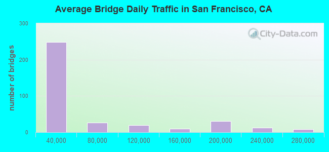
- 17,990,574Total average daily traffic
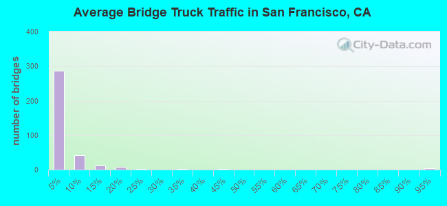
- 561,159Total average daily truck traffic
- National Bridge Inventory (NBI) Registered Bridges for San Francisco
- No street view available for this location
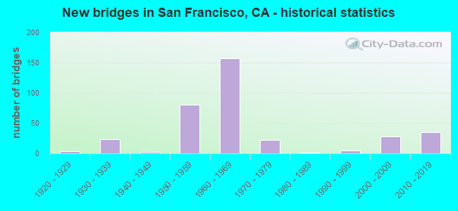
- New bridges - historical statistics
- 11900-1909
- 11910-1919
- 31920-1929
- 231930-1939
- 21940-1949
- 801950-1959
- 1571960-1969
- 221970-1979
- 11980-1989
- 51990-1999
- 282000-2009
- 352010-2019
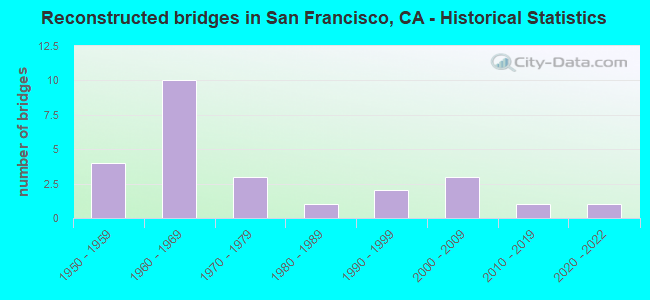
- Reconstructed bridges - Historical Statistics
- 41950-1959
- 101960-1969
- 31970-1979
- 11980-1989
- 21990-1999
- 32000-2009
- 12010-2019
- 12020-2022
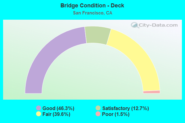
- Bridge Condition - Deck
- 46.3%Good
- 12.7%Satisfactory
- 39.6%Fair
- 1.5%Poor
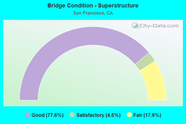
- Bridge Condition - Superstructure
- 77.6%Good
- 4.5%Satisfactory
- 17.9%Fair
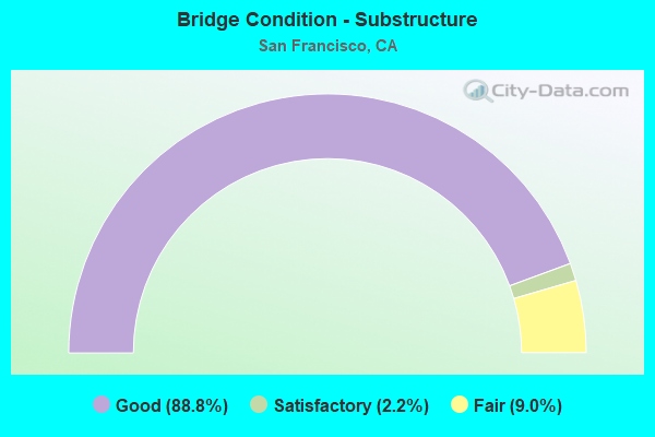
- Bridge Condition - Substructure
- 88.8%Good
- 2.2%Satisfactory
- 9.0%Fair
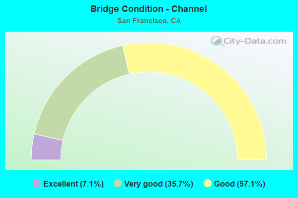
- Bridge Condition - Channel
- 7.1%Excellent
- 35.7%Very good
- 57.1%Good
Find on map >> Show street view
Structure Number: 34 0126L, Location: 04-SF-080-4.92-SF (Lat: 37.780253, Lng: -122.398706), Route carried "under" structure: City street , Year Built: 2008, Structure Length: 0. m, Average Daily Traffic: 27,000 (year 2015), Truck Traffic: 2%, Features Intersected: 2ND, 3RD AND 4TH STREET, Facility Carried by Structure: INTERSTATE 80 WB
Minimum Vertical Clearance: 12.70m (41.67ft), Kilometerpoint: 0.000, Lanes on structure: 4, Lanes under structure: 6, Material/Design: Prestressed concrete continuous, Design/Construction: Box Beam or Girders - Single/Spread, Length of Maximum Span: 49.7m (163.1ft)
Find on map >> Show street view
Structure Number: 34 0126R, Location: 04-SF-080-4.92-SF (Lat: 37.781158, Lng: -122.397453), Route carried "under" structure: City street , Year Built: 2008, Structure Length: 0. m, Average Daily Traffic: 27,000 (year 2015), Truck Traffic: 2%, Features Intersected: 2ND, 3RD, AND 4TH, Facility Carried by Structure: INTERSTATE 80 EB
Minimum Vertical Clearance: 7.26m (23.82ft), Kilometerpoint: 0.000, Lanes on structure: 3, Lanes under structure: 6, Material/Design: Prestressed concrete continuous, Design/Construction: Box Beam or Girders - Single/Spread, Length of Maximum Span: 45.7m (149.9ft)
Find on map >> Show street view
Structure Number: 34 0126R, Location: 04-SF-080-4.92-SF (Lat: 37.781158, Lng: -122.397453), Route carried "under" structure: City street , Year Built: 2008, Structure Length: 0. m, Average Daily Traffic: 3,000 (year 2015), Truck Traffic: 2%, Features Intersected: 2ND, 3RD, AND 4TH, Facility Carried by Structure: INTERSTATE 80 EB
Minimum Vertical Clearance: 4.88m (16.01ft), Kilometerpoint: 0.000, Lanes on structure: 3, Lanes under structure: 5, Material/Design: Prestressed concrete continuous, Design/Construction: Box Beam or Girders - Single/Spread, Length of Maximum Span: 45.7m (149.9ft)
Find on map >> Show street view
Structure Number: 34 0127S, Location: 04-SF-080-5.62R-SF (Lat: 37.787953, Lng: -122.395094), Route carried "under" structure: City street , Year Built: 2008, Structure Length: 0. m, Average Daily Traffic: 5,000 (year 2012), Truck Traffic: 1%, Features Intersected: ESX,HARR,CLEM,FOLSOM,1ST, Facility Carried by Structure: WB80-FREMONT ST
Minimum Vertical Clearance: 6.19m (20.31ft), Kilometerpoint: 0.000, Lanes on structure: 2, Lanes under structure: 2, Material/Design: Prestressed concrete continuous, Design/Construction: Box Beam or Girders - Single/Spread, Length of Maximum Span: 40.5m (132.9ft)
Find on map >> Show street view
Structure Number: 34 0127S, Location: 04-SF-080-5.62R-SF (Lat: 37.787953, Lng: -122.395094), Route carried "under" structure: City street , Year Built: 2008, Structure Length: 0. m, Average Daily Traffic: 2,000 (year 2012), Truck Traffic: 1%, Features Intersected: ESX,HARR,CLEM,FOLSOM,1ST, Facility Carried by Structure: WB80-FREMONT ST
Minimum Vertical Clearance: 6.24m (20.47ft), Kilometerpoint: 0.000, Lanes on structure: 2, Lanes under structure: 1, Material/Design: Prestressed concrete continuous, Design/Construction: Box Beam or Girders - Single/Spread, Length of Maximum Span: 40.5m (132.9ft)
Find on map >> Show street view
Structure Number: 34 0127S, Location: 04-SF-080-5.62R-SF (Lat: 37.787953, Lng: -122.395094), Route carried "under" structure: City street , Year Built: 2008, Structure Length: 0. m, Average Daily Traffic: 11,700 (year 2012), Truck Traffic: 1%, Features Intersected: ESX,HARR,CLEM,FOLSOM,1ST, Facility Carried by Structure: WB80-FREMONT ST
Minimum Vertical Clearance: 4.56m (14.96ft), Kilometerpoint: 0.000, Lanes on structure: 2, Lanes under structure: 4, Material/Design: Prestressed concrete continuous, Design/Construction: Box Beam or Girders - Single/Spread, Length of Maximum Span: 40.5m (132.9ft)
Find on map >> Show street view
Structure Number: 34 0127S, Location: 04-SF-080-5.62R-SF (Lat: 37.787953, Lng: -122.395094), Route carried "under" structure: City street , Year Built: 2008, Structure Length: 0. m, Average Daily Traffic: 16,000 (year 2012), Truck Traffic: 1%, Features Intersected: ESX,HARR,CLEM,FOLSOM,1ST, Facility Carried by Structure: WB80-FREMONT ST
Minimum Vertical Clearance: 5.86m (19.23ft), Kilometerpoint: 0.000, Lanes on structure: 2, Lanes under structure: 4, Material/Design: Prestressed concrete continuous, Design/Construction: Box Beam or Girders - Single/Spread, Length of Maximum Span: 40.5m (132.9ft)
Find on map >> Show street view
Structure Number: 34 0127S, Location: 04-SF-080-5.62R-SF (Lat: 37.787953, Lng: -122.395094), Route carried "under" structure: Business City street , Year Built: 2008, Structure Length: 0. m, Average Daily Traffic: 10,000 (year 2012), Truck Traffic: 1%, Features Intersected: ESX,HARR,CLEM,FOLSOM,1ST, Facility Carried by Structure: WB80-FREMONT ST
Minimum Vertical Clearance: 6.19m (20.31ft), Kilometerpoint: 0.000, Lanes on structure: 2, Lanes under structure: 5, Material/Design: Prestressed concrete continuous, Design/Construction: Box Beam or Girders - Single/Spread, Length of Maximum Span: 40.5m (132.9ft)
Find on map >> Show street view
Structure Number: 34 0128K, Location: 04-SF-080-5.50L-SF (Lat: 37.784581, Lng: -122.393297), Route carried "under" structure: Ramp Interstate 80, Year Built: 2008, Structure Length: 0. m, Average Daily Traffic: 4,850 (year 2012), Truck Traffic: 1%, Features Intersected: STERLING-E80,BRYANT,RNCN
Minimum Vertical Clearance: 8.50m (27.89ft), Kilometerpoint: 4.900, Lanes on structure: 1, Lanes under structure: 2, Toll: Toll bridge, Material/Design: Concrete continuous, Design/Construction: Box Beam or Girders - Single/Spread, Length of Maximum Span: 34.5m (113.2ft)
Find on map >> Show street view
Structure Number: 34 0129C, Location: 04-SF-080-4.97-SF (Lat: 37.779181, Lng: -122.400236), Route carried "under" structure: City street , Year Built: 2008, Structure Length: 0. m, Average Daily Traffic: 9,900 (year 2015), Truck Traffic: 2%, Features Intersected: 4TH STREET, Facility Carried by Structure: 80 WB OFF RAMP
Minimum Vertical Clearance: 4.95m (16.24ft), Kilometerpoint: 0.000, Lanes on structure: 2, Lanes under structure: 4, Material/Design: Prestressed concrete continuous, Design/Construction: Box Beam or Girders - Single/Spread, Length of Maximum Span: 41.8m (137.1ft)
Find on map >> Show street view
Structure Number: 34 0131L, Location: 04-SF-280-R4.18L-SF (Lat: 37.734636, Lng: -122.409547), Route carried "under" structure: Business City street D008, Year Built: 1960, Structure Length: 0. m, Average Daily Traffic: 24,800 (year 2019), Truck Traffic: 3%, Features Intersected: 280/101 INTERCHANGE, Facility Carried by Structure: I 280 S, AU LINE
Minimum Vertical Clearance: 5.79m (19.00ft), Kilometerpoint: 0.000, Lanes on structure: 2, Lanes under structure: 4, Material/Design: Concrete continuous, Design/Construction: Box Beam or Girders - Multiple, Length of Maximum Span: 29.3m (96.1ft)
Find on map >> Show street view
Structure Number: 34 0131L, Location: 04-SF-280-R4.18L-SF (Lat: 37.734636, Lng: -122.409547), Route carried "under" structure: US 101, Year Built: 1960, Structure Length: 0. m, Average Daily Traffic: 234,000 (year 2019), Truck Traffic: 3%, Features Intersected: 280/101 INTERCHANGE, Facility Carried by Structure: I 280 S, AU LINE
Minimum Vertical Clearance: 5.79m (19.00ft), Kilometerpoint: 1.980, Lanes on structure: 2, Lanes under structure: 8, Material/Design: Concrete continuous, Design/Construction: Box Beam or Girders - Multiple, Length of Maximum Span: 29.3m (96.1ft)
Find on map >> Show street view
Structure Number: 34 0131L, Location: 04-SF-280-R4.18L-SF (Lat: 37.734636, Lng: -122.409547), Route carried "under" structure: Business City street D095, Year Built: 1960, Structure Length: 0. m, Average Daily Traffic: 15,000 (year 2018), Truck Traffic: 3%, Features Intersected: 280/101 INTERCHANGE, Facility Carried by Structure: I 280 S, AU LINE
Minimum Vertical Clearance: 5.79m (19.00ft), Kilometerpoint: 0.000, Lanes on structure: 2, Lanes under structure: 2, Material/Design: Concrete continuous, Design/Construction: Box Beam or Girders - Multiple, Length of Maximum Span: 29.3m (96.1ft)
Find on map >> Show street view
Structure Number: 34 0132R, Location: 04-SF-280-R4.16R-SF (Lat: 37.734122, Lng: -122.409661), Route carried "under" structure: Business City street D008, Year Built: 1960, Structure Length: 0. m, Average Daily Traffic: 24,800 (year 2019), Truck Traffic: 3%, Features Intersected: 280/101 INTERCHANGE, Facility Carried by Structure: I 280 N, AL LINE
Minimum Vertical Clearance: 5.79m (19.00ft), Kilometerpoint: 0.000, Lanes on structure: 2, Lanes under structure: 4, Material/Design: Concrete continuous, Design/Construction: Box Beam or Girders - Multiple, Length of Maximum Span: 30.2m (99.1ft)
Find on map >> Show street view
Structure Number: 34 0132R, Location: 04-SF-280-R4.16R-SF (Lat: 37.734122, Lng: -122.409661), Route carried "under" structure: US 101, Year Built: 1960, Structure Length: 0. m, Average Daily Traffic: 234,000 (year 2019), Truck Traffic: 3%, Features Intersected: 280/101 INTERCHANGE, Facility Carried by Structure: I 280 N, AL LINE
Minimum Vertical Clearance: 5.79m (19.00ft), Kilometerpoint: 1.980, Lanes on structure: 2, Lanes under structure: 8, Material/Design: Concrete continuous, Design/Construction: Box Beam or Girders - Multiple, Length of Maximum Span: 30.2m (99.1ft)
Find on map >> Show street view
Structure Number: 34 0132R, Location: 04-SF-280-R4.16R-SF (Lat: 37.734122, Lng: -122.409661), Route carried "under" structure: Ramp Interstate 280, Year Built: 1960, Structure Length: 0. m, Average Daily Traffic: 30,000 (year 2019), Truck Traffic: 3%, Features Intersected: 280/101 INTERCHANGE
Minimum Vertical Clearance: 4.59m (15.06ft), Kilometerpoint: 4.160, Lanes on structure: 2, Lanes under structure: 2, Material/Design: Concrete continuous, Design/Construction: Box Beam or Girders - Multiple, Length of Maximum Span: 30.2m (99.1ft)
Find on map >> Show street view
Structure Number: 34 0132R, Location: 04-SF-280-R4.16R-SF (Lat: 37.734122, Lng: -122.409661), Route carried "under" structure: Business City street D095, Year Built: 1960, Structure Length: 0. m, Average Daily Traffic: 15,800 (year 2019), Truck Traffic: 3%, Features Intersected: 280/101 INTERCHANGE, Facility Carried by Structure: I 280 N, AL LINE
Minimum Vertical Clearance: 5.79m (19.00ft), Kilometerpoint: 0.000, Lanes on structure: 2, Lanes under structure: 2, Material/Design: Concrete continuous, Design/Construction: Box Beam or Girders - Multiple, Length of Maximum Span: 30.2m (99.1ft)
Find on map >> Show street view
Structure Number: 34 0134G, Location: 04-SF-280-R4.16R-SF (Lat: 37.734228, Lng: -122.409736), Route carried "under" structure: Interstate 101, Year Built: 1960, Structure Length: 0. m, Average Daily Traffic: 261,000 (year 2019), Truck Traffic: 3%, Features Intersected: 280/101 INTERCHANGE
Minimum Vertical Clearance: 5.79m (19.00ft), Kilometerpoint: 1.980, Lanes on structure: 2, Lanes under structure: 6, Material/Design: Concrete continuous, Design/Construction: Box Beam or Girders - Multiple, Length of Maximum Span: 48.8m (160.1ft)
Find on map >> Show street view
Structure Number: 34 0134G, Location: 04-SF-280-R4.16R-SF (Lat: 37.734228, Lng: -122.409736), Route carried "under" structure: Ramp Interstate 280, Year Built: 1960, Structure Length: 0. m, Average Daily Traffic: 30,000 (year 2019), Truck Traffic: 3%, Features Intersected: 280/101 INTERCHANGE
Minimum Vertical Clearance: 6.30m (20.67ft), Kilometerpoint: 4.160, Lanes on structure: 2, Lanes under structure: 2, Material/Design: Concrete continuous, Design/Construction: Box Beam or Girders - Multiple, Length of Maximum Span: 48.8m (160.1ft)
Find on map >> Show street view
Structure Number: 34 0134G, Location: 04-SF-280-R4.16R-SF (Lat: 37.734228, Lng: -122.409736), Route carried "under" structure: Ramp City street , Year Built: 1960, Structure Length: 0. m, Average Daily Traffic: 4,000 (year 2019), Truck Traffic: 5%, Features Intersected: 280/101 INTERCHANGE, Facility Carried by Structure: I 280N-101N (RE)
Minimum Vertical Clearance: 5.91m (19.39ft), Kilometerpoint: 0.000, Lanes on structure: 2, Lanes under structure: 1, Material/Design: Concrete continuous, Design/Construction: Box Beam or Girders - Multiple, Length of Maximum Span: 48.8m (160.1ft)
Find on map >> Show street view
Structure Number: 34 0134G, Location: 04-SF-280-R4.16R-SF (Lat: 37.734228, Lng: -122.409736), Route carried "under" structure: Business City street D101, Year Built: 1960, Structure Length: 0. m, Average Daily Traffic: 11,600 (year 2019), Truck Traffic: 3%, Features Intersected: 280/101 INTERCHANGE, Facility Carried by Structure: I 280N-101N (RE)
Minimum Vertical Clearance: 5.79m (19.00ft), Kilometerpoint: 0.000, Lanes on structure: 2, Lanes under structure: 2, Material/Design: Concrete continuous, Design/Construction: Box Beam or Girders - Multiple, Length of Maximum Span: 48.8m (160.1ft)
Find on map >> Show street view
Structure Number: 34 0134G, Location: 04-SF-280-R4.16R-SF (Lat: 37.734228, Lng: -122.409736), Route carried "under" structure: Business City street D014, Year Built: 1960, Structure Length: 0. m, Average Daily Traffic: 17,700 (year 2019), Truck Traffic: 3%, Features Intersected: 280/101 INTERCHANGE, Facility Carried by Structure: I 280N-101N (RE)
Minimum Vertical Clearance: 5.85m (19.19ft), Kilometerpoint: 0.000, Lanes on structure: 2, Lanes under structure: 2, Material/Design: Concrete continuous, Design/Construction: Box Beam or Girders - Multiple, Length of Maximum Span: 48.8m (160.1ft)
Find on map >> Show street view
Structure Number: 34 0134G, Location: 04-SF-280-R4.16R-SF (Lat: 37.734228, Lng: -122.409736), Route carried "under" structure: Business City street , Year Built: 1960, Structure Length: 0. m, Average Daily Traffic: 15,800 (year 2019), Truck Traffic: 3%, Features Intersected: 280/101 INTERCHANGE, Facility Carried by Structure: I 280N-101N (RE)
Minimum Vertical Clearance: 5.79m (19.00ft), Kilometerpoint: 0.000, Lanes on structure: 2, Lanes under structure: 2, Material/Design: Concrete continuous, Design/Construction: Box Beam or Girders - Multiple, Length of Maximum Span: 48.8m (160.1ft)
Find on map >> Show street view
Structure Number: 34 0134G, Location: 04-SF-280-R4.16R-SF (Lat: 37.734228, Lng: -122.409736), Route carried "under" structure: Ramp US 101, Year Built: 1960, Structure Length: 0. m, Average Daily Traffic: 30,000 (year 2019), Truck Traffic: 3%, Features Intersected: 280/101 INTERCHANGE
Minimum Vertical Clearance: 5.82m (19.09ft), Kilometerpoint: 1.980, Lanes on structure: 2, Lanes under structure: 2, Material/Design: Concrete continuous, Design/Construction: Box Beam or Girders - Multiple, Length of Maximum Span: 48.8m (160.1ft)
Find on map >> Show street view
Structure Number: 34 0134G, Location: 04-SF-280-R4.16R-SF (Lat: 37.734228, Lng: -122.409736), Route carried "under" structure: Ramp US 101, Year Built: 1960, Structure Length: 0. m, Average Daily Traffic: 30,000 (year 2019), Truck Traffic: 3%, Features Intersected: 280/101 INTERCHANGE
Minimum Vertical Clearance: 5.79m (19.00ft), Kilometerpoint: 1.980, Lanes on structure: 2, Lanes under structure: 1, Material/Design: Concrete continuous, Design/Construction: Box Beam or Girders - Multiple, Length of Maximum Span: 48.8m (160.1ft)
Find on map >> Show street view
Structure Number: 34 0134G, Location: 04-SF-280-R4.16R-SF (Lat: 37.734228, Lng: -122.409736), Route carried "under" structure: Ramp Interstate 280, Year Built: 1960, Structure Length: 0. m, Average Daily Traffic: 30,000 (year 2019), Truck Traffic: 3%, Features Intersected: 280/101 INTERCHANGE
Minimum Vertical Clearance: 4.82m (15.81ft), Kilometerpoint: 4.160, Lanes on structure: 2, Lanes under structure: 2, Material/Design: Concrete continuous, Design/Construction: Box Beam or Girders - Multiple, Length of Maximum Span: 48.8m (160.1ft)
Find on map >> Show street view
Structure Number: 34 0135G, Location: 04-SF-101-1.79-SF (Lat: 37.732967, Lng: -122.404989), Route carried "under" structure: Business City street , Year Built: 1960, Structure Length: 0. m, Average Daily Traffic: 4,000 (year 2019), Truck Traffic: 10%, Features Intersected: 280/101 INTERCHANGE, Facility Carried by Structure: US101N-I 280S (WL)
Minimum Vertical Clearance: 5.79m (19.00ft), Kilometerpoint: 0.000, Lanes on structure: 1, Lanes under structure: 2, Material/Design: Concrete continuous, Design/Construction: Box Beam or Girders - Multiple, Length of Maximum Span: 36.9m (121.1ft)
Find on map >> Show street view
Structure Number: 34 0135G, Location: 04-SF-101-1.79-SF (Lat: 37.732967, Lng: -122.404989), Route carried "under" structure: US 101, Year Built: 1960, Structure Length: 0. m, Average Daily Traffic: 221,000 (year 2019), Truck Traffic: 3%, Features Intersected: 280/101 INTERCHANGE
Minimum Vertical Clearance: 5.79m (19.00ft), Kilometerpoint: 1.980, Lanes on structure: 1, Lanes under structure: 7, Material/Design: Concrete continuous, Design/Construction: Box Beam or Girders - Multiple, Length of Maximum Span: 36.9m (121.1ft)
Find on map >> Show street view
Structure Number: 34 0135G, Location: 04-SF-101-1.79-SF (Lat: 37.732967, Lng: -122.404989), Route carried "under" structure: Business City street D095, Year Built: 1960, Structure Length: 0. m, Average Daily Traffic: 15,800 (year 2019), Truck Traffic: 3%, Features Intersected: 280/101 INTERCHANGE, Facility Carried by Structure: US101N-I 280S (WL)
Minimum Vertical Clearance: 5.79m (19.00ft), Kilometerpoint: 0.000, Lanes on structure: 1, Lanes under structure: 2, Material/Design: Concrete continuous, Design/Construction: Box Beam or Girders - Multiple, Length of Maximum Span: 36.9m (121.1ft)
Find on map >> Show street view
Structure Number: 34 0136G, Location: 04-SF-101-1.79-SF (Lat: 37.732706, Lng: -122.404858), Route carried "under" structure: Interstate 101, Year Built: 1960, Structure Length: 0. m, Average Daily Traffic: 221,000 (year 2019), Truck Traffic: 3%, Features Intersected: 280/101 INTERCHANGE
Minimum Vertical Clearance: 5.84m (19.16ft), Kilometerpoint: 1.980, Lanes on structure: 2, Lanes under structure: 6, Material/Design: Concrete continuous, Design/Construction: Box Beam or Girders - Multiple, Length of Maximum Span: 31.2m (102.4ft)
Find on map >> Show street view
Structure Number: 34 0136G, Location: 04-SF-101-1.79-SF (Lat: 37.732706, Lng: -122.404858), Route carried "under" structure: Ramp Interstate 280, Year Built: 1960, Structure Length: 0. m, Average Daily Traffic: 30,000 (year 2019), Truck Traffic: 3%, Features Intersected: 280/101 INTERCHANGE
Minimum Vertical Clearance: 30.10m (98.75ft), Kilometerpoint: 4.070, Lanes on structure: 2, Lanes under structure: 2, Material/Design: Concrete continuous, Design/Construction: Box Beam or Girders - Multiple, Length of Maximum Span: 31.2m (102.4ft)
Find on map >> Show street view
Structure Number: 34 0136G, Location: 04-SF-101-1.79-SF (Lat: 37.732706, Lng: -122.404858), Route carried "under" structure: Business City street , Year Built: 1960, Structure Length: 0. m, Average Daily Traffic: 4,000 (year 2019), Truck Traffic: 10%, Features Intersected: 280/101 INTERCHANGE, Facility Carried by Structure: 280N - 101S (WU)
Minimum Vertical Clearance: 5.62m (18.44ft), Kilometerpoint: 0.000, Lanes on structure: 2, Lanes under structure: 2, Material/Design: Concrete continuous, Design/Construction: Box Beam or Girders - Multiple, Length of Maximum Span: 31.2m (102.4ft)
Find on map >> Show street view
Structure Number: 34 0136G, Location: 04-SF-101-1.79-SF (Lat: 37.732706, Lng: -122.404858), Route carried "under" structure: Business City street D095, Year Built: 1960, Structure Length: 0. m, Average Daily Traffic: 15,800 (year 2019), Truck Traffic: 3%, Features Intersected: 280/101 INTERCHANGE, Facility Carried by Structure: 280N - 101S (WU)
Minimum Vertical Clearance: 5.83m (19.13ft), Kilometerpoint: 0.000, Lanes on structure: 2, Lanes under structure: 2, Material/Design: Concrete continuous, Design/Construction: Box Beam or Girders - Multiple, Length of Maximum Span: 31.2m (102.4ft)
Find on map >> Show street view
Structure Number: 34 0138C, Location: 04-SF-080-4.97-SF (Lat: 37.779164, Lng: -122.400097), Route carried "under" structure: City street , Year Built: 2008, Structure Length: 0. m, Average Daily Traffic: 9,900 (year 2015), Truck Traffic: 2%, Features Intersected: 4TH STREET, Facility Carried by Structure: 80 EB ONRAMP
Minimum Vertical Clearance: 5.36m (17.59ft), Kilometerpoint: 0.000, Lanes on structure: 1, Lanes under structure: 2, Material/Design: Prestressed concrete continuous, Design/Construction: Box Beam or Girders - Single/Spread, Length of Maximum Span: 41.8m (137.1ft)
Find on map >> Show street view
Structure Number: 34 0139, Location: 04-SF-101-2.91-SF (Lat: 37.749633, Lng: -122.403308), Route carried "under" structure: Ramp US 101, Year Built: 2004, Structure Length: 0. m, Average Daily Traffic: 12,400 (year 2010), Truck Traffic: 4%, Features Intersected: SB 101 OFF-RMP TO CS.CHV, Facility Carried by Structure: BIKE & PEDESTRIAN
Minimum Vertical Clearance: 4.90m (16.08ft), Kilometerpoint: 2.910, Lanes under structure: 1, Material/Design: Prestressed concrete, Design/Construction: Slab, Length of Maximum Span: 21.5m (70.5ft)
Find on map >> Show street view
Structure Number: 34 0155L, Location: 04-SF-101-R9.58-SF (Lat: 37.803472, Lng: -122.470822), Route carried "under" structure: Ramp State highway 1, Year Built: 2011, Structure Length: 0. m, Average Daily Traffic: 8,500 (year 2015), Truck Traffic: 3%, Features Intersected: 101 NB - 1 SB CONNECTOR
Minimum Vertical Clearance: 5.18m (16.99ft), Kilometerpoint: 7.000, Lanes on structure: 7, Lanes under structure: 2, Material/Design: Concrete, Design/Construction: Slab, Length of Maximum Span: 12.0m (39.4ft)
Find on map >> Show street view
Structure Number: 34 0155R, Location: 04-SF-101-R9.48-SF (Lat: 37.803667, Lng: -122.470639), Route carried "under" structure: Ramp US 101, Year Built: 2015, Structure Length: 0. m, Average Daily Traffic: 59,000 (year 2009), Truck Traffic: 1%, Features Intersected: 101 NB - 1 SB CONNECTOR
Minimum Vertical Clearance: 5.15m (16.90ft), Kilometerpoint: 9.500, Lanes on structure: 3, Lanes under structure: 1, Material/Design: Concrete, Design/Construction: Slab, Length of Maximum Span: 11.3m (37.1ft)
Find on map >> Show street view
Structure Number: 34 0157L, Location: 04-SF-101-R9.35-SF (Lat: 37.802025, Lng: -122.465272), Route carried "under" structure: Ramp US 1, Year Built: 2012, Structure Length: 0. m, Average Daily Traffic: 8,000 (year 2019), Truck Traffic: 3%, Features Intersected: RTE 1 RMPS,CRISSY,COWLES
Minimum Vertical Clearance: 5.18m (16.99ft), Kilometerpoint: 7.030, Lanes on structure: 5, Lanes under structure: 2, Material/Design: Prestressed concrete continuous, Design/Construction: Box Beam or Girders - Single/Spread, Length of Maximum Span: 83.8m (274.9ft)
Find on map >> Show street view
Structure Number: 34 0157R, Location: 04-SF-101-R9.18-SF (Lat: 37.802200, Lng: -122.465225), Route carried "under" structure: State highway 1, Year Built: 2015, Structure Length: 0. m, Average Daily Traffic: 64,000 (year 2019), Truck Traffic: 2%, Features Intersected: RTE 1N, LINCOLN,MCDOWELL
Minimum Vertical Clearance: 5.33m (17.49ft), Kilometerpoint: 7.070, Lanes on structure: 4, Lanes under structure: 2, Material/Design: Prestressed concrete continuous, Design/Construction: Box Beam or Girders - Multiple, Length of Maximum Span: 83.8m (274.9ft)
Find on map >> Show street view
Structure Number: 34 0159G, Location: 04-SF-101-R9.40-SF (Lat: 37.803333, Lng: -122.469444), Route carried "under" structure: State highway 1, Year Built: 2015, Structure Length: 0. m, Average Daily Traffic: 64,000 (year 2019), Truck Traffic: 2%, Features Intersected: STATE ROUTE 1
Minimum Vertical Clearance: 5.18m (16.99ft), Kilometerpoint: 7.070, Lanes on structure: 1, Lanes under structure: 2, Material/Design: Prestressed concrete continuous, Design/Construction: Box Beam or Girders - Multiple, Length of Maximum Span: 30.8m (101.0ft)
Find on map >> Show street view
Structure Number: 34 0160G, Location: 04-SF-001-7.00-SF (Lat: 37.801717, Lng: -122.469200), Route carried "under" structure: Business City street , Year Built: 2012, Structure Length: 0. m, Average Daily Traffic: 3,250 (year 2019), Truck Traffic: 3%, Features Intersected: LINCOLN BLVD, Facility Carried by Structure: 1NB-101S CONNECTOR
Minimum Vertical Clearance: 5.46m (17.91ft), Kilometerpoint: 0.000, Lanes on structure: 1, Lanes under structure: 2, Material/Design: Prestressed concrete continuous, Design/Construction: Box Beam or Girders - Single/Spread, Length of Maximum Span: 36.6m (120.1ft)
Find on map >> Show street view
Structure Number: 34 0177, Location: 04-SF-101-R4.74-SF (Lat: 37.770142, Lng: -122.419456), Route carried "under" structure: Business City street , Year Built: 2005, Structure Length: 0. m, Average Daily Traffic: 23,380 (year 2019), Truck Traffic: 3%, Features Intersected: 13TH ST,MISSION &OTIS ST, Facility Carried by Structure: U.S. HIGHWAY 101
Minimum Vertical Clearance: 5.54m (18.18ft), Kilometerpoint: 0.000, Lanes on structure: 4, Lanes under structure: 4, Material/Design: Steel continuous, Design/Construction: Stringer/Multi-beam, Length of Maximum Span: 58.0m (190.3ft)
Find on map >> Show street view
Structure Number: 34 0177, Location: 04-SF-101-R4.74-SF (Lat: 37.770142, Lng: -122.419456), Route carried "under" structure: Business City street , Year Built: 2005, Structure Length: 0. m, Average Daily Traffic: 22,000 (year 2019), Truck Traffic: 3%, Features Intersected: 13TH ST,MISSION &OTIS ST, Facility Carried by Structure: U.S. HIGHWAY 101
Minimum Vertical Clearance: 5.23m (17.16ft), Kilometerpoint: 0.000, Lanes on structure: 4, Lanes under structure: 6, Material/Design: Steel continuous, Design/Construction: Stringer/Multi-beam, Length of Maximum Span: 58.0m (190.3ft)
Find on map >> Show street view
Structure Number: 34 0177, Location: 04-SF-101-R4.74-SF (Lat: 37.770142, Lng: -122.419456), Route carried "under" structure: Business City street , Year Built: 2005, Structure Length: 0. m, Average Daily Traffic: 33,000 (year 2019), Truck Traffic: 3%, Features Intersected: 13TH ST,MISSION &OTIS ST, Facility Carried by Structure: U.S. HIGHWAY 101
Minimum Vertical Clearance: 4.95m (16.24ft), Kilometerpoint: 0.000, Lanes on structure: 4, Lanes under structure: 6, Material/Design: Steel continuous, Design/Construction: Stringer/Multi-beam, Length of Maximum Span: 58.0m (190.3ft)
Find on map >> Show street view
Structure Number: 34 0177, Location: 04-SF-101-R4.74-SF (Lat: 37.770142, Lng: -122.419456), Route carried "under" structure: Business City street , Year Built: 2005, Structure Length: 0. m, Average Daily Traffic: 23,000 (year 2019), Truck Traffic: 3%, Features Intersected: 13TH ST,MISSION &OTIS ST, Facility Carried by Structure: U.S. HIGHWAY 101
Minimum Vertical Clearance: 4.95m (16.24ft), Kilometerpoint: 0.000, Lanes on structure: 4, Lanes under structure: 3, Material/Design: Steel continuous, Design/Construction: Stringer/Multi-beam, Length of Maximum Span: 58.0m (190.3ft)
Find on map >> Show street view
Structure Number: 34 0177, Location: 04-SF-101-R4.74-SF (Lat: 37.770142, Lng: -122.419456), Route carried "under" structure: Business City street , Year Built: 2005, Structure Length: 0. m, Average Daily Traffic: 19,000 (year 2019), Truck Traffic: 3%, Features Intersected: 13TH ST,MISSION &OTIS ST, Facility Carried by Structure: U.S. HIGHWAY 101
Minimum Vertical Clearance: 5.61m (18.41ft), Kilometerpoint: 0.000, Lanes on structure: 4, Lanes under structure: 7, Material/Design: Steel continuous, Design/Construction: Stringer/Multi-beam, Length of Maximum Span: 58.0m (190.3ft)
Find on map >> Show street view
Structure Number: 34C0002, Location: PENNSYLVANIA AVE (Lat: 37.749811, Lng: -122.393114), Route carried "under" structure: City street , Year Built: 1936, Structure Length: 0. m, Average Daily Traffic: 20,729 (year 2016), Truck Traffic: 10%, Features Intersected: CESAR CHAVEZ ST, Facility Carried by Structure: CALTRAIN & UP RR
Minimum Vertical Clearance: 4.47m (14.67ft), Kilometerpoint: 0.000, Lanes under structure: 4, Material/Design: Steel, Design/Construction: Girder and Floorbeam System, Length of Maximum Span: 22.7m (74.5ft)
Find on map >> Show street view
Structure Number: 34C0014, Location: OVER SAN JOSE AVE (Lat: 37.734614, Lng: -122.428950), Route carried "under" structure: City street , Year Built: 1963, Structure Length: 0. m, Average Daily Traffic: 36,960 (year 2016), Truck Traffic: 4%, Features Intersected: SAN JOSE AVE, Facility Carried by Structure: PEDESTRIAN WALKWAY
Minimum Vertical Clearance: 5.38m (17.65ft), Kilometerpoint: 0.000, Lanes under structure: 6, Material/Design: Concrete continuous, Design/Construction: Tee Beam, Length of Maximum Span: 40.1m (131.6ft)
Find on map >> Show street view
Structure Number: 34C0015, Location: SOUTH OF 34C0016 (Lat: 37.736514, Lng: -122.426983), Route carried "under" structure: City street , Year Built: 1927, Structure Length: 0. m, Average Daily Traffic: 50,000 (year 2016), Truck Traffic: 4%, Features Intersected: SAN JOSE AVE, Facility Carried by Structure: RICHLAND AVE
Minimum Vertical Clearance: 7.00m (22.97ft), Kilometerpoint: 0.000, Lanes on structure: 2, Lanes under structure: 6, Material/Design: Concrete continuous, Design/Construction: Tee Beam, Length of Maximum Span: 36.9m (121.1ft)
Find on map >> Show street view
Structure Number: 34C0016, Location: NORTH OF 34C0015 (Lat: 37.737697, Lng: -122.425447), Route carried "under" structure: City street , Year Built: 1930, Structure Length: 0. m, Average Daily Traffic: 50,000 (year 2016), Truck Traffic: 4%, Features Intersected: SAN JOSE AVE, Facility Carried by Structure: HIGHLAND AVE
Minimum Vertical Clearance: 7.62m (25.00ft), Kilometerpoint: 0.000, Lanes on structure: 2, Lanes under structure: 6, Material/Design: Concrete continuous, Design/Construction: Tee Beam, Length of Maximum Span: 36.9m (121.1ft)
Find on map >> Show street view
Structure Number: 34C0017, Location: OVER BOSWORTH STREET (Lat: 37.733753, Lng: -122.435667), Route carried "under" structure: City street , Year Built: 1965, Structure Length: 0. m, Average Daily Traffic: 22,315 (year 2016), Truck Traffic: 1%, Features Intersected: BOSWORTH STREET, Facility Carried by Structure: PEDESTRIAN WALKWAY
Minimum Vertical Clearance: 4.60m (15.09ft), Kilometerpoint: 0.000, Lanes under structure: 4, Material/Design: Prestressed concrete, Design/Construction: Tee Beam, Length of Maximum Span: 31.1m (102.0ft)
Find on map >> Show street view
Structure Number: 34C0018, Location: OVER ARMY STREET (Lat: 37.748772, Lng: -122.406178), Route carried "under" structure: City street , Year Built: 1972, Structure Length: 0. m, Average Daily Traffic: 63,120 (year 2016), Truck Traffic: 5%, Features Intersected: CESAR CHAVEZ ST, Facility Carried by Structure: PEDESTRIAN WALKWAY
Minimum Vertical Clearance: 5.77m (18.93ft), Kilometerpoint: 0.000, Lanes under structure: 6, Material/Design: Prestressed concrete, Design/Construction: Box Beam or Girders - Single/Spread, Length of Maximum Span: 46.1m (151.2ft)
Find on map >> Show street view
Structure Number: 34C0021, Location: OVER CESAR CHAVEZ ST (Lat: 37.749089, Lng: -122.404764), Route carried "under" structure: City street , Year Built: 1974, Structure Length: 0. m, Average Daily Traffic: 30,960 (year 2011), Truck Traffic: 5%, Features Intersected: CESAR CHAVEZ ST, Facility Carried by Structure: POTRERO AVE
Minimum Vertical Clearance: 4.69m (15.39ft), Kilometerpoint: 0.000, Lanes on structure: 2, Lanes under structure: 4, Material/Design: Prestressed concrete, Design/Construction: Box Beam or Girders - Multiple, Length of Maximum Span: 27.0m (88.6ft)
Find on map >> Show street view
Structure Number: 34C0031, Location: OVER MARKET ST (Lat: 37.752289, Lng: -122.442986), Route carried "under" structure: City street , Year Built: 1958, Structure Length: 0. m, Average Daily Traffic: 27,000 (year 2010), Truck Traffic: 2%, Features Intersected: MARKET STREET, Facility Carried by Structure: PEDESTRIAN WALKWAY
Minimum Vertical Clearance: 4.75m (15.58ft), Kilometerpoint: 0.000, Lanes under structure: 4, Material/Design: Concrete continuous, Design/Construction: Tee Beam, Length of Maximum Span: 29.6m (97.1ft)
Find on map >> Show street view
Structure Number: 34C0033, Location: OVER MARKET STREET (Lat: 37.756322, Lng: -122.441269), Route carried "under" structure: City street , Year Built: 1958, Structure Length: 0. m, Average Daily Traffic: 25,989 (year 2007), Truck Traffic: 2%, Features Intersected: MARKET STREET, Facility Carried by Structure: PEDESTRIAN WALKWAY
Minimum Vertical Clearance: 4.67m (15.32ft), Kilometerpoint: 0.000, Lanes under structure: 4, Material/Design: Concrete, Design/Construction: Stringer/Multi-beam, Length of Maximum Span: 30.5m (100.1ft)
Find on map >> Show street view
Structure Number: 34C0035, Location: OVER BROADWAY (Lat: 37.796242, Lng: -122.418328), Route carried "under" structure: City street , Year Built: 1952, Structure Length: 0. m, Average Daily Traffic: 50,000 (year 2015), Truck Traffic: 1%, Features Intersected: BROADWAY, Facility Carried by Structure: HYDE ST
Minimum Vertical Clearance: 5.33m (17.49ft), Kilometerpoint: 0.000, Lanes on structure: 2, Lanes under structure: 4, Material/Design: Concrete continuous, Design/Construction: Tee Beam, Length of Maximum Span: 10.1m (33.1ft)
Find on map >> Show street view
Structure Number: 34C0039, Location: OVER PORTOLA DRIVE (Lat: 37.740350, Lng: -122.459486), Route carried "under" structure: City street , Year Built: 1971, Structure Length: 0. m, Average Daily Traffic: 25,989 (year 2016), Truck Traffic: 2%, Features Intersected: PORTOLA DRIVE, Facility Carried by Structure: PEDESTRIAN WALKWAY
Minimum Vertical Clearance: 4.55m (14.93ft), Kilometerpoint: 0.000, Lanes under structure: 4, Material/Design: Concrete continuous, Design/Construction: Box Beam or Girders - Single/Spread, Length of Maximum Span: 33.0m (108.3ft)
Find on map >> Show street view
Structure Number: 34C0042, Location: OVER GEARY BLVD (Lat: 37.784322, Lng: -122.432772), Route carried "under" structure: City street , Year Built: 1961, Structure Length: 0. m, Average Daily Traffic: 41,040 (year 2017), Truck Traffic: 5%, Features Intersected: GEARY BLVD, Facility Carried by Structure: FILLMORE ST
Minimum Vertical Clearance: 4.62m (15.16ft), Kilometerpoint: 0.000, Lanes on structure: 4, Lanes under structure: 6, Material/Design: Prestressed concrete, Design/Construction: Tee Beam, Length of Maximum Span: 25.6m (84.0ft)
Find on map >> Show street view
Structure Number: 34C0043, Location: OVER GEARY BLVD (Lat: 37.784422, Lng: -122.430928), Route carried "under" structure: City street , Year Built: 1966, Structure Length: 0. m, Average Daily Traffic: 52,440 (year 2011), Truck Traffic: 5%, Features Intersected: GEARY BLVD, Facility Carried by Structure: PEDESTRIAN WALKWAY
Minimum Vertical Clearance: 4.11m (13.48ft), Kilometerpoint: 0.000, Lanes under structure: 10, Material/Design: Prestressed concrete, Design/Construction: Box Beam or Girders - Single/Spread, Length of Maximum Span: 13.4m (44.0ft)
Find on map >> Show street view
Structure Number: 34C0047, Location: NEAR CANDLESTICK (Lat: 37.711239, Lng: -122.386678), Route carried "under" structure: City street , Year Built: 1969, Structure Length: 0. m, Average Daily Traffic: 960 (year 2011), Truck Traffic: 5%, Features Intersected: JAMESTOWN WAY, Facility Carried by Structure: PEDESTRIAN WALKWAY
Minimum Vertical Clearance: 4.72m (15.49ft), Kilometerpoint: 0.000, Lanes under structure: 4, Material/Design: Concrete, Design/Construction: Box Beam or Girders - Single/Spread, Length of Maximum Span: 27.7m (90.9ft)
Find on map >> Show street view
Structure Number: 34C0048, Location: NEAR CANDLESTICK PARK (Lat: 37.711042, Lng: -122.386575), Route carried "under" structure: City street , Year Built: 1969, Structure Length: 0. m, Average Daily Traffic: 2,640 (year 2016), Truck Traffic: 5%, Features Intersected: HARNEY WAY, Facility Carried by Structure: PEDESTRIAN WALKWAY
Minimum Vertical Clearance: 5.00m (16.40ft), Kilometerpoint: 0.000, Lanes under structure: 4, Material/Design: Concrete, Design/Construction: Box Beam or Girders - Single/Spread, Length of Maximum Span: 27.7m (90.9ft)
Find on map >> Show street view
Structure Number: 34C0052, Location: RANKIN ST (Lat: 37.741356, Lng: -122.394272), Route carried "under" structure: City street , Year Built: 1907, Structure Length: 0. m, Average Daily Traffic: 7,320 (year 2016), Truck Traffic: 5%, Features Intersected: JERROLD AVENUE, Facility Carried by Structure: CALTRAIN & UP RR
Minimum Vertical Clearance: 4.60m (15.09ft), Kilometerpoint: 0.000, Lanes under structure: 2, Material/Design: Steel, Design/Construction: Girder and Floorbeam System, Length of Maximum Span: 13.2m (43.3ft)
Find on map >> Show street view
Structure Number: 34C0053, Location: I-280 (Lat: 37.745911, Lng: -122.393658), Route carried "under" structure: City street , Year Built: 1964, Structure Length: 0. m, Average Daily Traffic: 15,840 (year 2016), Truck Traffic: 5%, Features Intersected: EVANS AVENUE, Facility Carried by Structure: CALTRAIN & UP RR
Minimum Vertical Clearance: 4.67m (15.32ft), Kilometerpoint: 0.000, Lanes under structure: 4, Material/Design: Steel, Design/Construction: Girder and Floorbeam System, Length of Maximum Span: 28.0m (91.9ft)
Find on map >> Show street view
Structure Number: 34C0057, Location: OVER BEAGLE ST (Lat: 37.787297, Lng: -122.391206), Route carried "under" structure: City street , Year Built: 1936, Structure Length: 0. m, Average Daily Traffic: 10,000 (year 2017), Truck Traffic: 10%, Features Intersected: BEALE STREET, Facility Carried by Structure: HARRISON STREET
Minimum Vertical Clearance: 7.62m (25.00ft), Kilometerpoint: 0.000, Lanes on structure: 4, Lanes under structure: 2, Material/Design: Concrete continuous, Design/Construction: Tee Beam, Length of Maximum Span: 25.1m (82.3ft)
Find on map >> Show street view
Structure Number: 34C006, Location: OVER WASHINGTON ST (Lat: 37.796061, Lng: -122.398625), Route carried "under" structure: City street , Year Built: 1967, Structure Length: 0. m, Average Daily Traffic: 7,320 (year 2011), Truck Traffic: 2%, Features Intersected: WASHINGTON ST, Facility Carried by Structure: PEDESTRIAN WALKWAY
Minimum Vertical Clearance: 6.00m (19.69ft), Kilometerpoint: 0.000, Lanes under structure: 3, Material/Design: Concrete, Design/Construction: Box Beam or Girders - Multiple, Length of Maximum Span: 22.3m (73.2ft)
Find on map >> Show street view
Structure Number: 34C0061, Location: OVER WASHINGTON ST (Lat: 37.795875, Lng: -122.399850), Route carried "under" structure: City street , Year Built: 1967, Structure Length: 0. m, Average Daily Traffic: 7,320 (year 2011), Truck Traffic: 2%, Features Intersected: WASHINGTON ST, Facility Carried by Structure: PEDESTRIAN WALKWAY
Minimum Vertical Clearance: 5.87m (19.26ft), Kilometerpoint: 0.000, Lanes under structure: 4, Material/Design: Concrete, Design/Construction: Box Beam or Girders - Single/Spread, Length of Maximum Span: 22.3m (73.2ft)
Find on map >> Show street view
Structure Number: 34C0063, Location: OVER SUNSET BLVD (Lat: 37.764514, Lng: -122.496261), Route carried "under" structure: City street , Year Built: 1931, Structure Length: 0. m, Average Daily Traffic: 13,680 (year 2011), Truck Traffic: 1%, Features Intersected: SUNSET BLVD, Facility Carried by Structure: LINCOLN WAY
Minimum Vertical Clearance: 4.32m (14.17ft), Kilometerpoint: 0.000, Lanes on structure: 4, Lanes under structure: 4, Material/Design: Concrete continuous, Design/Construction: Tee Beam, Length of Maximum Span: 19.8m (65.0ft)
Find on map >> Show street view
Structure Number: 34C0064, Location: OVER BROTHERHOOD WAY (Lat: 37.713003, Lng: -122.473247), Route carried "under" structure: City street , Year Built: 1960, Structure Length: 0. m, Average Daily Traffic: 10,000 (year 2016), Truck Traffic: 5%, Features Intersected: BROTHERHOOD WY, Facility Carried by Structure: PEDESTRIAN WALKWAY
Minimum Vertical Clearance: 4.65m (15.26ft), Kilometerpoint: 0.000, Lanes under structure: 4, Material/Design: Prestressed concrete, Design/Construction: Tee Beam, Length of Maximum Span: 26.2m (86.0ft)
Find on map >> Show street view
Structure Number: 34C0066, Location: OVER OCEAN AVE (Lat: 37.722658, Lng: -122.451189), Route carried "under" structure: City street , Year Built: 1977, Structure Length: 0. m, Average Daily Traffic: 10,000 (year 2016), Truck Traffic: 12%, Features Intersected: OCEAN AVE, Facility Carried by Structure: PEDESTRIAN WALKWAY
Minimum Vertical Clearance: 5.97m (19.59ft), Kilometerpoint: 0.000, Lanes under structure: 4, Material/Design: Concrete, Design/Construction: Box Beam or Girders - Single/Spread, Length of Maximum Span: 17.4m (57.1ft)
Find on map >> Show street view
Structure Number: 34C0069, Location: 0.1 MI N OLYMPIA ON CL A (Lat: 37.753033, Lng: -122.456144), Route carried "under" structure: City street , Year Built: 1962, Structure Length: 0. m, Average Daily Traffic: 8,000 (year 2012), Truck Traffic: 10%, Features Intersected: CLARENDON AVE, Facility Carried by Structure: PEDESTRIAN WALKWAY
Minimum Vertical Clearance: 4.67m (15.32ft), Kilometerpoint: 0.000, Lanes under structure: 4, Material/Design: Prestressed concrete, Design/Construction: Stringer/Multi-beam, Length of Maximum Span: 32.9m (107.9ft)
Find on map >> Show street view
Structure Number: 34C0071, Location: 0.1 MI NW GIL AVE GRIF S (Lat: 37.718175, Lng: -122.388225), Route carried "under" structure: City street , Year Built: 1970, Structure Length: 0. m, Average Daily Traffic: 10,000 (year 2016), Truck Traffic: 5%, Features Intersected: GILMAN AVE, Facility Carried by Structure: PEDESTRIAN WALKWAY
Minimum Vertical Clearance: 5.08m (16.67ft), Kilometerpoint: 0.000, Lanes under structure: 4, Material/Design: Prestressed concrete, Design/Construction: Box Beam or Girders - Multiple, Length of Maximum Span: 27.4m (89.9ft)
Find on map >> Show street view
Structure Number: 34C0086, Location: JSO TERMINAL BUILDING (Lat: 37.785861, Lng: -122.395472), Route carried "under" structure: City street , Year Built: 2018, Structure Length: 0. m, Average Daily Traffic: 20,000 (year 2017), Truck Traffic: 15%, Features Intersected: HOWARD STREET, Facility Carried by Structure: TERMINAL BUS RAMP
Minimum Vertical Clearance: 7.00m (22.97ft), Kilometerpoint: 0.000, Lanes on structure: 2, Lanes under structure: 4, Material/Design: Concrete continuous, Design/Construction: Box Beam or Girders - Multiple, Length of Maximum Span: 57.6m (189.0ft)
Find on map >> Show street view
Structure Number: 34C0086, Location: JSO TERMINAL BUILDING (Lat: 37.785861, Lng: -122.395472), Route carried "under" structure: City street , Year Built: 2018, Structure Length: 0. m, Average Daily Traffic: 20,000 (year 2017), Truck Traffic: 15%, Features Intersected: HOWARD STREET, Facility Carried by Structure: TERMINAL BUS RAMP
Minimum Vertical Clearance: 7.00m (22.97ft), Kilometerpoint: 0.000, Lanes on structure: 2, Lanes under structure: 3, Material/Design: Concrete continuous, Design/Construction: Box Beam or Girders - Multiple, Length of Maximum Span: 57.6m (189.0ft)
Find on map >> Show street view
Structure Number: 34C0087L, Location: TO I80 EAST (Lat: 37.784833, Lng: -122.394306), Route carried "under" structure: City street , Year Built: 2018, Structure Length: 0. m, Average Daily Traffic: 20,000 (year 2017), Truck Traffic: 15%, Features Intersected: HARRISON STREET, Facility Carried by Structure: TRANSIT BUS RAMP
Minimum Vertical Clearance: 5.97m (19.59ft), Kilometerpoint: 0.000, Lanes on structure: 1, Lanes under structure: 4, Material/Design: Concrete, Design/Construction: Box Beam or Girders - Multiple, Length of Maximum Span: 25.7m (84.3ft)
Find on map >> Show street view
Structure Number: 34C0087R, Location: RETURN TO TRANSIT CENTER (Lat: 37.785000, Lng: -122.394111), Route carried "under" structure: City street , Year Built: 2018, Structure Length: 0. m, Average Daily Traffic: 20,000 (year 2017), Truck Traffic: 15%, Features Intersected: HARRISON STREET, Facility Carried by Structure: TRANSIT BUS RAMP
Minimum Vertical Clearance: 5.88m (19.29ft), Kilometerpoint: 0.000, Lanes on structure: 1, Lanes under structure: 4, Material/Design: Concrete, Design/Construction: Box Beam or Girders - Multiple, Length of Maximum Span: 25.7m (84.3ft)
Find on map >> Show street view
Structure Number: 34C0088, Location: NE OF THIRD STREET (Lat: 37.782361, Lng: -122.396444), Route carried "under" structure: City street , Year Built: 2018, Structure Length: 0. m, Average Daily Traffic: 20,000 (year 2017), Truck Traffic: 15%, Features Intersected: SECOND STREET, Facility Carried by Structure: BUS STORAGE RAMP
Minimum Vertical Clearance: 5.30m (17.39ft), Kilometerpoint: 0.000, Lanes on structure: 2, Lanes under structure: 4, Material/Design: Concrete continuous, Design/Construction: Box Beam or Girders - Multiple, Length of Maximum Span: 42.7m (140.1ft)