Bridge Statistics for Stockbridge, Georgia (GA)
Condition, Traffic, Stress, Structural Evaluation, Project Costs
- National Bridge Inventory (NBI) Statistics
- 84Number of bridges
- 938ft / 286mTotal length
- $246,838,000Total costs
- 2,682,670Total average daily traffic
- 97,008Total average daily truck traffic
- National Bridge Inventory (NBI) Registered Bridges for Stockbridge
- No street view available for this location
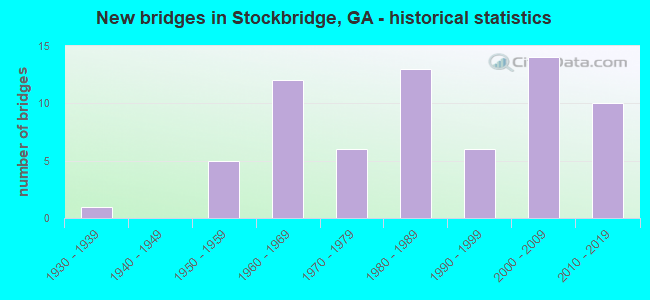
- New bridges - historical statistics
- 11930-1939
- 51950-1959
- 121960-1969
- 61970-1979
- 131980-1989
- 61990-1999
- 142000-2009
- 102010-2019

- Reconstructed bridges - Historical Statistics
- 11980-1989
- 21990-1999
- 12000-2009


- Bridge Condition - Deck
- 16.7%Very good
- 75.0%Good
- 2.8%Satisfactory
- 2.8%Fair
- 2.8%Imminent failure

- Bridge Condition - Superstructure
- 41.7%Very good
- 52.8%Good
- 2.8%Satisfactory
- 2.8%Imminent failure

- Bridge Condition - Substructure
- 13.9%Very good
- 80.6%Good
- 5.6%Fair

- Bridge Condition - Channel
- 5.9%Excellent
- 49.0%Very good
- 25.5%Good
- 15.7%Satisfactory
- 2.0%Fair
- 2.0%Poor

- Bridge Condition - Culverts
- 83.9%Good
- 16.1%Satisfactory
Find on map >> Show street view
Structure Number: 1515066, Location: 4 MI W OF MCDONOUGH (Lat: 33.462733, Lng: -84.210203), Route carried "on" structure: State highway 920, Year Built: 2002, Status: Open, Structure Length: 10.73m (35.20ft), Average Daily Traffic: 25,910 (year 2011), Truck Traffic: 1%, Average Future Daily Traffic: 38,865 (year 2031), Design Load: HS 20+Mod, Features Intersected: I-75, Facility Carried by Structure: JONESBORO ROAD
Minimum Vertical Clearance: 30+ m (98+ ft), Kilometerpoint: 8.047, Lanes on structure: 6, Lanes under structure: 6, Base Highway Network: Yes, Owner: State Highway Agency, Approaching Roadway Width: 27.1m (88.9ft), Skew: 3 degrees, Material/Design: Prestressed concrete, Design/Construction: Stringer/Multi-beam, Number Of Spans In Main Unit: 4, Length of Maximum Span: 38.7m (127.0ft), Curb-To-Curb Width: 27.6m (90.6ft), Out-to-Out Width: 28.8m (94.5ft)
Condition: Deck: Good, Superstructure: Good, Substructure: Good, Operating Rating: 48.9 metric tons, Method Used To Determine Operating Rating: Load Factor (LF), Inventory Rating: 29.0 metric tons, Method Used To Determine Inventory Rating: Load Factor (LF), Structural Evaluation: Better than present minimum criteria, Deck Geometry: Better than present minimum criteria, Underclear: Equal to present minimum criteria, Approach Roadway Alignment: Equal to present desirable criteria, Designated Inspection Frequency: Every 24 months, Inspection Date: December 2020, Bridge Improvement Cost: $2,876,000, Roadway Improvement Cost: $288,000, Total Project Cost: $4,314,000, Deck Structure Type: Concrete Cast-file-Place
Find on map >> Show street view
Structure Number: 1515076, Location: 2 MI W OF McDONOUGH (Lat: 33.455128, Lng: -84.213739), Route carried "on" structure: County highway 1175, Year Built: 2003, Status: Open, Structure Length: 0.70m (2.30ft), Average Daily Traffic: 6,050 (year 2011), Truck Traffic: 1%, Average Future Daily Traffic: 9,075 (year 2031), Design Load: HS 20+Mod, Features Intersected: CRITTLE CREEK, Facility Carried by Structure: MILL ROAD
Minimum Vertical Clearance: 30+ m (98+ ft), Kilometerpoint: 3.219, Lanes on structure: 2, Base Highway Network: Yes, Owner: County Highway Agency, Approaching Roadway Width: 7.3m (24.0ft), Material/Design: Concrete, Design/Construction: Culvert, Number Of Spans In Main Unit: 3, Length of Maximum Span: 2.1m (6.9ft)
Condition: Channel: Very good, Culverts: Good, Operating Rating: 55.3 metric tons, Method Used To Determine Operating Rating: Field evaluation and documented engineering judgment, Inventory Rating: 32.6 metric tons, Method Used To Determine Inventory Rating: Field evaluation and documented engineering judgment, Structural Evaluation: Better than present minimum criteria, Waterway Adequacy: Better than present minimum criteria, Approach Roadway Alignment: Equal to present desirable criteria, Designated Inspection Frequency: Every 24 months, Inspection Date: November 2020, Bridge Improvement Cost: $90,000, Roadway Improvement Cost: $9,000, Total Project Cost: $135,000
Find on map >> Show street view
Structure Number: 1515089, Location: 3 MI E OF STOCKBRIDGE (Lat: 33.551258, Lng: -84.178758), Route carried "on" structure: State highway 138, Year Built: 2006, Status: Open, Structure Length: 4.94m (16.21ft), Average Daily Traffic: 11,120 (year 2011), Truck Traffic: 1%, Average Future Daily Traffic: 16,680 (year 2031), Design Load: HS 20+Mod, Features Intersected: BIG COTTON INDIAN CREEK
Minimum Vertical Clearance: 30+ m (98+ ft), Kilometerpoint: 9.656, Lanes on structure: 2, Base Highway Network: Yes, Owner: State Highway Agency, Approaching Roadway Width: 8.5m (27.9ft), Skew: 3 degrees, Material/Design: Prestressed concrete, Design/Construction: Stringer/Multi-beam, Number Of Spans In Main Unit: 3, Length of Maximum Span: 16.5m (54.1ft), Curb-To-Curb Width: 13.4m (44.0ft), Out-to-Out Width: 14.4m (47.2ft)
Condition: Deck: Good, Superstructure: Very good, Substructure: Very good, Channel: Excellent, Operating Rating: 51.7 metric tons, Method Used To Determine Operating Rating: Allowable Stress (AS), Inventory Rating: 32.6 metric tons, Method Used To Determine Inventory Rating: Allowable Stress (AS), Structural Evaluation: Equal to present desirable criteria, Deck Geometry: Equal to present minimum criteria, Waterway Adequacy: Equal to present desirable criteria, Approach Roadway Alignment: Equal to present desirable criteria, Designated Inspection Frequency: Every 24 months, Inspection Date: November 2020, Bridge Improvement Cost: $633,000, Roadway Improvement Cost: $63,000, Total Project Cost: $949,000, Deck Structure Type: Concrete Cast-file-Place
Find on map >> Show street view
Structure Number: 1515091, Location: 2 MI EAST OF STOCKBRIDGE (Lat: 33.551969, Lng: -84.185697), Route carried "on" structure: County highway 100, Year Built: 2007, Status: Open, Structure Length: 3.84m (12.60ft), Average Daily Traffic: 3,370 (year 2011), Truck Traffic: 1%, Average Future Daily Traffic: 5,055 (year 2031), Design Load: HS 20+Mod, Features Intersected: BRUSH CREEK, Facility Carried by Structure: FLAT ROCK ROAD
Minimum Vertical Clearance: 30+ m (98+ ft), Kilometerpoint: 1.609, Lanes on structure: 2, Base Highway Network: Yes, Owner: County Highway Agency, Approaching Roadway Width: 6.1m (20.0ft), Material/Design: Prestressed concrete, Design/Construction: Stringer/Multi-beam, Number Of Spans In Main Unit: 3, Length of Maximum Span: 26.2m (86.0ft), Curb-To-Curb Width: 12.2m (40.0ft), Out-to-Out Width: 13.3m (43.6ft)
Condition: Deck: Very good, Superstructure: Very good, Substructure: Good, Channel: Very good, Operating Rating: 67.1 metric tons, Method Used To Determine Operating Rating: Allowable Stress (AS), Inventory Rating: 19.0 metric tons, Method Used To Determine Inventory Rating: Allowable Stress (AS), Structural Evaluation: Somewhat better than minimum adequacy, Deck Geometry: Equal to present minimum criteria, Waterway Adequacy: Equal to present desirable criteria, Approach Roadway Alignment: Equal to present desirable criteria, Designated Inspection Frequency: Every 24 months, Inspection Date: October 2020, Bridge Improvement Cost: $492,000, Roadway Improvement Cost: $49,000, Total Project Cost: $738,000, Deck Structure Type: Concrete Cast-file-Place
Find on map >> Show street view
Structure Number: 1515097, Location: 6.5 MI NORTH OF HAMPTON (Lat: 33.469389, Lng: -84.230019), Route carried "on" structure: County highway 181, Year Built: 2000, Status: Open, Structure Length: 1.34m (4.40ft), Average Daily Traffic: 5,330 (year 2011), Truck Traffic: 1%, Average Future Daily Traffic: 7,995 (year 2031), Design Load: HS 20+Mod, Features Intersected: WALNUT CREEK, Facility Carried by Structure: CHAMBERS ROAD
Minimum Vertical Clearance: 30+ m (98+ ft), Kilometerpoint: 6.437, Lanes on structure: 2, Base Highway Network: Yes, Owner: County Highway Agency, Approaching Roadway Width: 6.1m (20.0ft), Material/Design: Concrete, Design/Construction: Culvert, Number Of Spans In Main Unit: 4, Length of Maximum Span: 3.0m (9.8ft)
Condition: Channel: Very good, Culverts: Good, Operating Rating: 55.3 metric tons, Method Used To Determine Operating Rating: Field evaluation and documented engineering judgment, Inventory Rating: 32.6 metric tons, Method Used To Determine Inventory Rating: Field evaluation and documented engineering judgment, Structural Evaluation: Better than present minimum criteria, Waterway Adequacy: Equal to present desirable criteria, Approach Roadway Alignment: Equal to present desirable criteria, Designated Inspection Frequency: Every 24 months, Inspection Date: October 2020, Bridge Improvement Cost: $172,000, Roadway Improvement Cost: $17,000, Total Project Cost: $258,000
Find on map >> Show street view
Structure Number: 1515098, Location: 5.5 MI NORTH OF HAMPTON (Lat: 33.456247, Lng: -84.230750), Route carried "on" structure: County highway 181, Year Built: 2000, Status: Open, Structure Length: 1.13m (3.71ft), Average Daily Traffic: 880 (year 2011), Truck Traffic: 1%, Average Future Daily Traffic: 1,320 (year 2031), Design Load: HS 20+Mod, Features Intersected: CRITTLE CREEK, Facility Carried by Structure: CHAMBERS ROAD
Minimum Vertical Clearance: 30+ m (98+ ft), Kilometerpoint: 4.828, Lanes on structure: 2, Base Highway Network: Yes, Owner: County Highway Agency, Approaching Roadway Width: 6.4m (21.0ft), Skew: 4 degrees, Material/Design: Concrete, Design/Construction: Culvert, Number Of Spans In Main Unit: 3, Length of Maximum Span: 3.4m (11.2ft)
Condition: Channel: Very good, Culverts: Good, Operating Rating: 55.3 metric tons, Method Used To Determine Operating Rating: Field evaluation and documented engineering judgment, Inventory Rating: 32.6 metric tons, Method Used To Determine Inventory Rating: Field evaluation and documented engineering judgment, Structural Evaluation: Better than present minimum criteria, Waterway Adequacy: Equal to present desirable criteria, Approach Roadway Alignment: Superior to present desirable criteria, Designated Inspection Frequency: Every 24 months, Inspection Date: October 2020, Bridge Improvement Cost: $145,000, Roadway Improvement Cost: $14,000, Total Project Cost: $217,000
Find on map >> Show street view
Structure Number: 1515099, Location: 7 MI NORTH WEST OF MCDONO (Lat: 33.486589, Lng: -84.266508), Route carried "on" structure: County highway 174, Year Built: 2005, Status: Open, Structure Length: 0.98m (3.22ft), Average Daily Traffic: 1,390 (year 2011), Truck Traffic: 1%, Average Future Daily Traffic: 2,085 (year 2031), Design Load: HS 20+Mod, Features Intersected: PATES CREEK, Facility Carried by Structure: PATES CREEK ROAD
Minimum Vertical Clearance: 30+ m (98+ ft), Kilometerpoint: 1.609, Lanes on structure: 2, Base Highway Network: Yes, Owner: County Highway Agency, Approaching Roadway Width: 7.3m (24.0ft), Material/Design: Concrete, Design/Construction: Culvert, Number Of Spans In Main Unit: 3, Length of Maximum Span: 3.0m (9.8ft)
Condition: Channel: Very good, Culverts: Good, Operating Rating: 55.3 metric tons, Method Used To Determine Operating Rating: Field evaluation and documented engineering judgment, Inventory Rating: 32.6 metric tons, Method Used To Determine Inventory Rating: Field evaluation and documented engineering judgment, Structural Evaluation: Better than present minimum criteria, Waterway Adequacy: Equal to present desirable criteria, Approach Roadway Alignment: Superior to present desirable criteria, Designated Inspection Frequency: Every 24 months, Inspection Date: October 2020, Bridge Improvement Cost: $125,000, Roadway Improvement Cost: $13,000, Total Project Cost: $188,000
Find on map >> Show street view
Structure Number: 15151, Location: NORTH STOCKBRIDGE (Lat: 33.552608, Lng: -84.233278), Route carried "on" structure: County highway 667, Year Built: 1995, Status: Open, Structure Length: 0.76m (2.49ft), Average Daily Traffic: 8,520 (year 2011), Truck Traffic: 1%, Average Future Daily Traffic: 12,780 (year 2031), Design Load: H 15, Features Intersected: BRUSH CREEK, Facility Carried by Structure: EAST ATLANTA ROAD
Minimum Vertical Clearance: 30+ m (98+ ft), Kilometerpoint: 1.609, Lanes on structure: 3, Base Highway Network: Yes, Owner: County Highway Agency, Approaching Roadway Width: 7.9m (25.9ft), Skew: 2 degrees, Material/Design: Steel, Design/Construction: Culvert, Number Of Spans In Main Unit: 3, Length of Maximum Span: 2.1m (6.9ft), Curb or Sidewalk Widths: Left: 1.5m (4.9ft), Right: 0.2m (0.7ft)
Condition: Channel: Very good, Culverts: Good, Operating Rating: 41.7 metric tons, Method Used To Determine Operating Rating: Field evaluation and documented engineering judgment, Inventory Rating: 24.4 metric tons, Method Used To Determine Inventory Rating: Field evaluation and documented engineering judgment, Structural Evaluation: Equal to present minimum criteria, Waterway Adequacy: Equal to present minimum criteria, Approach Roadway Alignment: Better than present minimum criteria, Designated Inspection Frequency: Every 24 months, Inspection Date: October 2020, Bridge Improvement Cost: $124,000, Roadway Improvement Cost: $12,000, Total Project Cost: $186,000
Find on map >> Show street view
Structure Number: 1515102, Location: 3.5 MI WEST OF STOCKBRIDG (Lat: 33.538119, Lng: -84.284947), Route carried "on" structure: County highway 1580, Year Built: 2000, Status: Open, Structure Length: 0.73m (2.40ft), Average Daily Traffic: 1,940 (year 2011), Truck Traffic: 1%, Average Future Daily Traffic: 2,910 (year 2031), Design Load: H 15, Features Intersected: REEVES CREEK TRIB, Facility Carried by Structure: SPIVEY GLENN DRIVE
Minimum Vertical Clearance: 30+ m (98+ ft), Kilometerpoint: 0.000, Lanes on structure: 2, Base Highway Network: Yes, Owner: County Highway Agency, Approaching Roadway Width: 7.6m (24.9ft), Material/Design: Steel, Design/Construction: Culvert, Number Of Spans In Main Unit: 1, Length of Maximum Span: 7.3m (24.0ft), Curb or Sidewalk Widths: Left: 1.2m (3.9ft), Right: 1.2m (3.9ft)
Condition: Channel: Very good, Culverts: Good, Operating Rating: 41.7 metric tons, Method Used To Determine Operating Rating: Field evaluation and documented engineering judgment, Inventory Rating: 24.4 metric tons, Method Used To Determine Inventory Rating: Field evaluation and documented engineering judgment, Structural Evaluation: Equal to present minimum criteria, Waterway Adequacy: Equal to present desirable criteria, Approach Roadway Alignment: Superior to present desirable criteria, Designated Inspection Frequency: Every 24 months, Inspection Date: December 2020, Bridge Improvement Cost: $94,000, Roadway Improvement Cost: $9,000, Total Project Cost: $141,000
Find on map >> Show street view
Structure Number: 1515104, Location: 5 MI NORTH OF MCDONOUGH (Lat: 33.525458, Lng: -84.139939), Route carried "on" structure: State highway 155, Year Built: 2008, Status: Open, Structure Length: 5.64m (18.50ft), Average Daily Traffic: 9,770 (year 2011), Truck Traffic: 1%, Average Future Daily Traffic: 14,655 (year 2031), Design Load: HS 20+Mod, Features Intersected: LITTLE COTTON INDIAN CR
Minimum Vertical Clearance: 30+ m (98+ ft), Kilometerpoint: 22.531, Lanes on structure: 2, Base Highway Network: Yes, Owner: State Highway Agency, Approaching Roadway Width: 8.5m (27.9ft), Material/Design: Prestressed concrete, Design/Construction: Stringer/Multi-beam, Number Of Spans In Main Unit: 3, Length of Maximum Span: 29.0m (95.1ft), Curb-To-Curb Width: 13.4m (44.0ft), Out-to-Out Width: 14.4m (47.2ft)
Condition: Deck: Very good, Superstructure: Very good, Substructure: Good, Channel: Very good, Operating Rating: 56.2 metric tons, Method Used To Determine Operating Rating: Allowable Stress (AS), Inventory Rating: 32.6 metric tons, Method Used To Determine Inventory Rating: Allowable Stress (AS), Structural Evaluation: Better than present minimum criteria, Deck Geometry: Equal to present minimum criteria, Waterway Adequacy: Equal to present desirable criteria, Approach Roadway Alignment: Equal to present desirable criteria, Designated Inspection Frequency: Every 24 months, Inspection Date: November 2020, Bridge Improvement Cost: $723,000, Roadway Improvement Cost: $72,000, Total Project Cost: $1,084,000, Deck Structure Type: Concrete Cast-file-Place
Find on map >> Show street view
Structure Number: 1515105, Location: 6 MI NORTH OF MCDONOUGH (Lat: 33.533208, Lng: -84.138958), Route carried "on" structure: State highway 155, Year Built: 2008, Status: Open, Structure Length: 11.92m (39.11ft), Average Daily Traffic: 5,230 (year 2011), Truck Traffic: 1%, Average Future Daily Traffic: 7,845 (year 2031), Design Load: HS 20+Mod, Features Intersected: BIG COTTON INDIAN CREEK
Minimum Vertical Clearance: 30+ m (98+ ft), Kilometerpoint: 24.140, Lanes on structure: 2, Base Highway Network: Yes, Owner: State Highway Agency, Approaching Roadway Width: 8.5m (27.9ft), Skew: 2 degrees, Material/Design: Prestressed concrete, Design/Construction: Stringer/Multi-beam, Number Of Spans In Main Unit: 4, Length of Maximum Span: 39.6m (129.9ft), Curb-To-Curb Width: 13.4m (44.0ft), Out-to-Out Width: 14.1m (46.3ft)
Condition: Deck: Good, Superstructure: Very good, Substructure: Very good, Channel: Very good, Operating Rating: 59.8 metric tons, Method Used To Determine Operating Rating: Allowable Stress (AS), Inventory Rating: 32.6 metric tons, Method Used To Determine Inventory Rating: Allowable Stress (AS), Structural Evaluation: Equal to present desirable criteria, Deck Geometry: Equal to present minimum criteria, Waterway Adequacy: Equal to present desirable criteria, Approach Roadway Alignment: Equal to present desirable criteria, Designated Inspection Frequency: Every 24 months, Inspection Date: November 2020, Bridge Improvement Cost: $1,528,000, Roadway Improvement Cost: $153,000, Total Project Cost: $2,292,000, Deck Structure Type: Concrete Cast-file-Place
Find on map >> Show street view
Structure Number: 1515106, Location: 3 MI S OF STOCKBRIDGE (Lat: 33.501769, Lng: -84.224039), Route carried "on" structure: County highway 2223, Year Built: 2007, Status: Open, Structure Length: 1.52m (4.99ft), Average Daily Traffic: 1,940 (year 2011), Truck Traffic: 1%, Average Future Daily Traffic: 2,910 (year 2031), Design Load: HS 20+Mod, Features Intersected: PATES CREEK, Facility Carried by Structure: PATRICK HENRY PKWY
Minimum Vertical Clearance: 30+ m (98+ ft), Kilometerpoint: 3.219, Lanes on structure: 2, Base Highway Network: Yes, Owner: County Highway Agency, Approaching Roadway Width: 9.8m (32.2ft), Skew: 3 degrees, Material/Design: Concrete, Design/Construction: Culvert, Number Of Spans In Main Unit: 4, Length of Maximum Span: 3.7m (12.1ft), Curb or Sidewalk Widths: Left: 0.0m, Right: 1.5m (4.9ft)
Condition: Channel: Very good, Culverts: Good, Operating Rating: 55.3 metric tons, Method Used To Determine Operating Rating: Field evaluation and documented engineering judgment, Inventory Rating: 32.6 metric tons, Method Used To Determine Inventory Rating: Field evaluation and documented engineering judgment, Structural Evaluation: Better than present minimum criteria, Waterway Adequacy: Equal to present desirable criteria, Approach Roadway Alignment: Better than present minimum criteria, Designated Inspection Frequency: Every 24 months, Inspection Date: November 2020, Bridge Improvement Cost: $195,000, Roadway Improvement Cost: $20,000, Total Project Cost: $293,000
Find on map >> Show street view
Structure Number: 1515107, Location: 3 MI SOUTH OF STOCKBRIDGE (Lat: 33.503128, Lng: -84.225458), Route carried "on" structure: County highway 2223, Year Built: 2007, Status: Open, Structure Length: 13.11m (43.01ft), Average Daily Traffic: 1,940 (year 2011), Truck Traffic: 1%, Average Future Daily Traffic: 2,910 (year 2031), Design Load: HS 20+Mod, Features Intersected: PATES CREEK OVER FLOW, Facility Carried by Structure: PATRICK HENRY PKWY
Minimum Vertical Clearance: 30+ m (98+ ft), Kilometerpoint: 3.219, Lanes on structure: 2, Base Highway Network: Yes, Owner: County Highway Agency, Approaching Roadway Width: 9.8m (32.2ft), Skew: 1 degrees, Material/Design: Prestressed concrete, Design/Construction: Stringer/Multi-beam, Number Of Spans In Main Unit: 3, Length of Maximum Span: 43.9m (144.0ft), Curb or Sidewalk Widths: Left: 1.8m (5.9ft), Right: 1.8m (5.9ft), Curb-To-Curb Width: 9.8m (32.2ft), Out-to-Out Width: 14.1m (46.3ft)
Condition: Deck: Good, Superstructure: Very good, Substructure: Good, Channel: Excellent, Operating Rating: 55.3 metric tons, Method Used To Determine Operating Rating: Allowable Stress (AS), Inventory Rating: 32.6 metric tons, Method Used To Determine Inventory Rating: Allowable Stress (AS), Structural Evaluation: Better than present minimum criteria, Deck Geometry: Somewhat better than minimum adequacy, Waterway Adequacy: Superior to present desirable criteria, Approach Roadway Alignment: Equal to present desirable criteria, Designated Inspection Frequency: Every 24 months, Inspection Date: November 2020, Bridge Improvement Cost: $1,680,000, Roadway Improvement Cost: $168,000, Total Project Cost: $2,520,000, Deck Structure Type: Concrete Cast-file-Place
Find on map >> Show street view
Structure Number: 151511, Location: 2 MI NW OF McDONOUGH (Lat: 33.470319, Lng: -84.198994), Route carried "on" structure: County highway 192, Year Built: 2010, Status: Open, Structure Length: 2.44m (8.01ft), Average Daily Traffic: 1,940 (year 2011), Truck Traffic: 1%, Average Future Daily Traffic: 2,910 (year 2031), Design Load: HS 20+Mod, Features Intersected: WALNUT CREEK, Facility Carried by Structure: FOSTER ROAD
Minimum Vertical Clearance: 30+ m (98+ ft), Kilometerpoint: 1.609, Lanes on structure: 2, Base Highway Network: Yes, Owner: County Highway Agency, Approaching Roadway Width: 6.1m (20.0ft), Material/Design: Prestressed concrete, Design/Construction: Box Beam or Girders - Multiple, Number Of Spans In Main Unit: 2, Length of Maximum Span: 12.2m (40.0ft), Curb-To-Curb Width: 12.2m (40.0ft), Out-to-Out Width: 13.5m (44.3ft)
Condition: Deck: Good, Superstructure: Very good, Substructure: Very good, Channel: Very good, Operating Rating: 63.5 metric tons, Method Used To Determine Operating Rating: Load Factor (LF), Inventory Rating: 37.1 metric tons, Method Used To Determine Inventory Rating: Load Factor (LF), Structural Evaluation: Equal to present desirable criteria, Deck Geometry: Better than present minimum criteria, Waterway Adequacy: Equal to present desirable criteria, Approach Roadway Alignment: Equal to present desirable criteria, Designated Inspection Frequency: Every 24 months, Inspection Date: November 2020, Bridge Improvement Cost: $313,000, Roadway Improvement Cost: $31,000, Total Project Cost: $469,000, Deck Structure Type: Concrete Precast Panels, Wearing Surface/Protective System: Wearing Surface: Monolithic Concrete
Find on map >> Show street view
Structure Number: 1515111, Location: 2 MI NORTH OF STOCKBRIDGE (Lat: 33.569667, Lng: -84.232928), Route carried "on" structure: County highway 2037, Year Built: 2010, Status: Open, Structure Length: 5.24m (17.19ft), Average Daily Traffic: 5,970 (year 2011), Truck Traffic: 1%, Average Future Daily Traffic: 8,955 (year 2031), Design Load: HS 20, Features Intersected: BIG COTTON INDIAN CREEK, Facility Carried by Structure: EAST ATLANTA ROAD
Minimum Vertical Clearance: 30+ m (98+ ft), Kilometerpoint: 3.219, Lanes on structure: 2, Base Highway Network: Yes, Owner: County Highway Agency, Approaching Roadway Width: 7.0m (23.0ft), Skew: 2 degrees, Material/Design: Prestressed concrete, Design/Construction: Stringer/Multi-beam, Number Of Spans In Main Unit: 3, Length of Maximum Span: 30.5m (100.1ft), Curb-To-Curb Width: 12.2m (40.0ft), Out-to-Out Width: 13.3m (43.6ft)
Condition: Deck: Very good, Superstructure: Very good, Substructure: Good, Channel: Very good, Operating Rating: 66.2 metric tons, Method Used To Determine Operating Rating: Load Factor (LF), Inventory Rating: 42.6 metric tons, Method Used To Determine Inventory Rating: Load Factor (LF), Structural Evaluation: Better than present minimum criteria, Deck Geometry: Somewhat better than minimum adequacy, Waterway Adequacy: Equal to present desirable criteria, Approach Roadway Alignment: Equal to present desirable criteria, Designated Inspection Frequency: Every 24 months, Inspection Date: December 2020, Bridge Improvement Cost: $672,000, Roadway Improvement Cost: $67,000, Total Project Cost: $1,008,000, Deck Structure Type: Concrete Cast-file-Place
Find on map >> Show street view
Structure Number: 1515112, Location: 3 MI SE OF STOCKBRIDGE (Lat: 33.518383, Lng: -84.197328), Route carried "on" structure: County highway 2673, Year Built: 2010, Status: Open, Structure Length: 11.58m (37.99ft), Average Daily Traffic: 21,220 (year 2011), Truck Traffic: 1%, Average Future Daily Traffic: 31,830 (year 2031), Design Load: HS 20+Mod, Features Intersected: PATES CREEK, Facility Carried by Structure: EAGLES LANDING PKY
Minimum Vertical Clearance: 30+ m (98+ ft), Kilometerpoint: 4.828, Lanes on structure: 4, Base Highway Network: Yes, Owner: County Highway Agency, Approaching Roadway Width: 19.5m (64.0ft), Skew: 23 degrees, Material/Design: Prestressed concrete, Design/Construction: Stringer/Multi-beam, Number Of Spans In Main Unit: 9, Length of Maximum Span: 15.2m (49.9ft), Curb or Sidewalk Widths: Left: 1.8m (5.9ft), Right: 1.8m (5.9ft), Curb-To-Curb Width: 31.7m (104.0ft), Out-to-Out Width: 36.1m (118.4ft)
Condition: Deck: Very good, Superstructure: Very good, Substructure: Good, Channel: Excellent, Operating Rating: 65.3 metric tons, Method Used To Determine Operating Rating: Load Factor (LF), Inventory Rating: 37.1 metric tons, Method Used To Determine Inventory Rating: Load Factor (LF), Structural Evaluation: Better than present minimum criteria, Deck Geometry: Superior to present desirable criteria, Waterway Adequacy: Equal to present desirable criteria, Approach Roadway Alignment: Equal to present desirable criteria, Designated Inspection Frequency: Every 24 months, Inspection Date: December 2020, Bridge Improvement Cost: $2,295,000, Roadway Improvement Cost: $229,000, Total Project Cost: $3,442,000, Deck Structure Type: Concrete Cast-file-Place
Find on map >> Show street view
Structure Number: 1515114, Location: 2 MI SE OF STOCKBRIDGE (Lat: 33.516100, Lng: -84.205736), Route carried "on" structure: County highway 2673, Year Built: 2011, Status: Open, Structure Length: 5.85m (19.19ft), Average Daily Traffic: 21,220 (year 2011), Truck Traffic: 1%, Average Future Daily Traffic: 31,830 (year 2031), Design Load: HS 20+Mod, Features Intersected: NS RAILROAD, Facility Carried by Structure: EAGLE'S LANDING PA
Minimum Vertical Clearance: 30+ m (98+ ft), Kilometerpoint: 4.828, Lanes on structure: 4, Base Highway Network: Yes, Owner: County Highway Agency, Approaching Roadway Width: 19.5m (64.0ft), Skew: 20 degrees, Material/Design: Prestressed concrete, Design/Construction: Stringer/Multi-beam, Number Of Spans In Main Unit: 3, Length of Maximum Span: 25.6m (84.0ft), Curb or Sidewalk Widths: Left: 1.8m (5.9ft), Right: 1.8m (5.9ft), Curb-To-Curb Width: 31.7m (104.0ft), Out-to-Out Width: 36.1m (118.4ft)
Condition: Deck: Good, Superstructure: Very good, Substructure: Good, Operating Rating: 47.1 metric tons, Method Used To Determine Operating Rating: Load Factor (LF), Inventory Rating: 28.1 metric tons, Method Used To Determine Inventory Rating: Load Factor (LF), Structural Evaluation: Better than present minimum criteria, Deck Geometry: Superior to present desirable criteria, Underclear: Superior to present desirable criteria, Approach Roadway Alignment: Equal to present desirable criteria, Designated Inspection Frequency: Every 24 months, Inspection Date: December 2020, Bridge Improvement Cost: $1,159,000, Roadway Improvement Cost: $116,000, Total Project Cost: $1,739,000, Deck Structure Type: Concrete Cast-file-Place
Find on map >> Show street view
Structure Number: 1515117, Location: 2 MI SW OF STOCKBRIDGE (Lat: 33.526608, Lng: -84.253978), Route carried "on" structure: City street 9321, Year Built: 2013, Status: Open, Structure Length: 8.99m (29.49ft), Average Daily Traffic: 13,150 (year 2011), Truck Traffic: 1%, Average Future Daily Traffic: 19,725 (year 2031), Design Load: HS 20+Mod, Features Intersected: I-75, Facility Carried by Structure: CR 660 WALT STEPHE
Minimum Vertical Clearance: 30+ m (98+ ft), Kilometerpoint: 3.219, Lanes on structure: 2, Lanes under structure: 7, Base Highway Network: Yes, Owner: State Highway Agency, Approaching Roadway Width: 7.3m (24.0ft), Material/Design: Prestressed concrete, Design/Construction: Stringer/Multi-beam, Number Of Spans In Main Unit: 2, Length of Maximum Span: 44.8m (147.0ft), Curb-To-Curb Width: 12.2m (40.0ft), Out-to-Out Width: 13.2m (43.3ft)
Condition: Deck: Good, Superstructure: Good, Substructure: Good, Operating Rating: 97.9 metric tons, Method Used To Determine Operating Rating: Load Factor (LF), Inventory Rating: 38.1 metric tons, Method Used To Determine Inventory Rating: Load Factor (LF), Structural Evaluation: Better than present minimum criteria, Deck Geometry: Somewhat better than minimum adequacy, Underclear: Somewhat better than minimum adequacy, Approach Roadway Alignment: Equal to present desirable criteria, Length Of Structure Improvement: 10.79m (35.40ft), Designated Inspection Frequency: Every 24 months, Inspection Date: November 2020, Bridge Improvement Cost: $26,196,000, Roadway Improvement Cost: $2,620,000, Total Project Cost: $39,294,000 ( Estimate for 2014), Deck Structure Type: Concrete Cast-file-Place
Find on map >> Show street view
Structure Number: 1515118, Location: 5 MI NW OF MCDONOUGH (Lat: 33.482231, Lng: -84.217250), Route carried "on" structure: County highway 1415, Year Built: 2014, Status: Open, Structure Length: 11.85m (38.88ft), Average Daily Traffic: 15,130 (year 2011), Truck Traffic: 1%, Average Future Daily Traffic: 22,695 (year 2031), Design Load: HS 20+Mod, Features Intersected: I-75, Facility Carried by Structure: CR 824 JODECO ROAD
Minimum Vertical Clearance: 30+ m (98+ ft), Kilometerpoint: 8.047, Lanes on structure: 8, Lanes under structure: 6, Base Highway Network: Yes, Owner: State Highway Agency, Approaching Roadway Width: 31.7m (104.0ft), Skew: 20 degrees, Material/Design: Prestressed concrete, Design/Construction: Stringer/Multi-beam, Number Of Spans In Main Unit: 4, Length of Maximum Span: 37.5m (123.0ft), Curb or Sidewalk Widths: Left: 1.7m (5.6ft), Right: 1.7m (5.6ft), Curb-To-Curb Width: 32.9m (107.9ft), Out-to-Out Width: 37.0m (121.4ft)
Condition: Deck: Good, Superstructure: Very good, Substructure: Good, Operating Rating: 63.5 metric tons, Method Used To Determine Operating Rating: Load Factor (LF), Inventory Rating: 35.3 metric tons, Method Used To Determine Inventory Rating: Load Factor (LF), Structural Evaluation: Better than present minimum criteria, Deck Geometry: Somewhat better than minimum adequacy, Underclear: Better than present minimum criteria, Approach Roadway Alignment: Equal to present desirable criteria, Length Of Structure Improvement: 14.20m (46.59ft), Designated Inspection Frequency: Every 24 months, Inspection Date: November 2020, Bridge Improvement Cost: $34,517,000, Roadway Improvement Cost: $3,452,000, Total Project Cost: $51,776,000 ( Estimate for 2014), Deck Structure Type: Concrete Cast-file-Place
Find on map >> Show street view
Structure Number: 151512, Location: .7 MI SE OF STOCKBRIDGE (Lat: 33.536731, Lng: -84.225681), Route carried "on" structure: County highway 171, Year Built: 2013, Status: Open, Structure Length: 7.16m (23.49ft), Average Daily Traffic: 8,240 (year 2011), Truck Traffic: 1%, Average Future Daily Traffic: 12,360 (year 2031), Design Load: HS 20+Mod, Features Intersected: NORFOLK SOUTHERN RR, Facility Carried by Structure: ROCK QUARRY ROAD
Minimum Vertical Clearance: 30+ m (98+ ft), Kilometerpoint: 3.219, Lanes on structure: 2, Base Highway Network: Yes, Owner: County Highway Agency, Approaching Roadway Width: 7.3m (24.0ft), Skew: 3 degrees, Material/Design: Prestressed concrete, Design/Construction: Stringer/Multi-beam, Number Of Spans In Main Unit: 3, Length of Maximum Span: 32.0m (105.0ft), Curb or Sidewalk Widths: Left: 1.7m (5.6ft), Right: 1.7m (5.6ft), Curb-To-Curb Width: 10.4m (34.1ft), Out-to-Out Width: 24.8m (81.4ft)
Condition: Deck: Good, Superstructure: Very good, Substructure: Good, Operating Rating: 78.0 metric tons, Method Used To Determine Operating Rating: Load Factor (LF), Inventory Rating: 46.2 metric tons, Method Used To Determine Inventory Rating: Load Factor (LF), Structural Evaluation: Better than present minimum criteria, Deck Geometry: Meets minimum limits, Underclear: Superior to present desirable criteria, Approach Roadway Alignment: Better than present minimum criteria, Length Of Structure Improvement: 8.60m (28.22ft), Designated Inspection Frequency: Every 24 months, Inspection Date: November 2020, Bridge Improvement Cost: $20,868,000, Roadway Improvement Cost: $2,086,000, Total Project Cost: $31,302,000 ( Estimate for 2017), Deck Structure Type: Concrete Cast-file-Place
Find on map >> Show street view
Structure Number: 1515123, Location: 2 MI W OF STOCKBRIDGE (Lat: 33.543581, Lng: -84.269197), Route carried "on" structure: Interstate 675, Year Built: 2016, Status: Open, Structure Length: 5.00m (16.40ft), Average Daily Traffic: 6,300 (year 2016), Average Future Daily Traffic: 7,680 (year 2036), Design Load: HS 20+Mod, Features Intersected: I-75
Minimum Vertical Clearance: 30+ m (98+ ft), Kilometerpoint: 0.000, Lanes on structure: 1, Lanes under structure: 5, Base Highway Network: Yes, Toll: On toll road, Owner: State Highway Agency, Approaching Roadway Width: 9.1m (29.9ft), Skew: 4 degrees, Material/Design: Prestressed concrete, Design/Construction: Stringer/Multi-beam, Number Of Spans In Main Unit: 1, Length of Maximum Span: 50.0m (164.0ft), Curb-To-Curb Width: 9.1m (29.9ft), Out-to-Out Width: 11.5m (37.7ft)
Condition: Deck: Good, Superstructure: Very good, Substructure: Very good, Inventory Rating: 40.8 metric tons, Method Used To Determine Inventory Rating: Load Factor (LF), Structural Evaluation: Equal to present desirable criteria, Deck Geometry: High priority of corrective action, Underclear: Equal to present minimum criteria, Approach Roadway Alignment: Equal to present minimum criteria, Length Of Structure Improvement: 6.13m (20.11ft), Designated Inspection Frequency: Every 24 months, Inspection Date: November 2020, Bridge Improvement Cost: $14,874,000, Roadway Improvement Cost: $1,487,000, Total Project Cost: $22,311,000 ( Estimate for 2017), Deck Structure Type: Concrete Cast-file-Place
Find on map >> Show street view
Structure Number: 1515125, Location: 4 MI NW OF McDONOUGH (Lat: 33.492567, Lng: -84.190681), Route carried "on" structure: County highway 657, Year Built: 2019, Status: Open, Structure Length: 7.28m (23.88ft), Average Daily Traffic: 15,500 (year 2015), Truck Traffic: 3%, Average Future Daily Traffic: 23,000 (year 2025), Design Load: HS 20+Mod, Features Intersected: NORFOLK SOUTHERN RR, Facility Carried by Structure: CAMPGROUND RD EXT
Minimum Vertical Clearance: 30+ m (98+ ft), Kilometerpoint: 1.609, Lanes on structure: 2, Base Highway Network: Yes, Owner: County Highway Agency, Approaching Roadway Width: 9.1m (29.9ft), Skew: 24 degrees, Material/Design: Prestressed concrete, Design/Construction: Stringer/Multi-beam, Number Of Spans In Main Unit: 3, Length of Maximum Span: 27.4m (89.9ft), Curb or Sidewalk Widths: Left: 1.7m (5.6ft), Right: 1.7m (5.6ft), Curb-To-Curb Width: 20.7m (67.9ft), Out-to-Out Width: 24.8m (81.4ft)
Condition: Deck: Very good, Superstructure: Good, Substructure: Good, Operating Rating: 80.7 metric tons, Method Used To Determine Operating Rating: Load Factor (LF), Inventory Rating: 46.2 metric tons, Method Used To Determine Inventory Rating: Load Factor (LF), Structural Evaluation: Better than present minimum criteria, Deck Geometry: Superior to present desirable criteria, Underclear: Superior to present desirable criteria, Approach Roadway Alignment: Equal to present desirable criteria, Length Of Structure Improvement: 8.75m (28.71ft), Designated Inspection Frequency: Every 24 months, Inspection Date: November 2020, Bridge Improvement Cost: $21,238,000, Roadway Improvement Cost: $2,124,000, Total Project Cost: $31,857,000 ( Estimate for 2019), Deck Structure Type: Concrete Cast-file-Place
Find on map >> Show street view
Structure Number: 1515127, Location: 3 MI SW OF STOCKBRIDGE (Lat: 33.517739, Lng: -84.277797), Route carried "on" structure: City street 661, Year Built: 2019, Status: Open, Structure Length: 5.94m (19.49ft), Average Daily Traffic: 6,040 (year 2007), Average Future Daily Traffic: 9,060 (year 2027), Design Load: HL 93, Features Intersected: RUM CREEK, Facility Carried by Structure: BLACKHALL ROAD
Minimum Vertical Clearance: 30+ m (98+ ft), Kilometerpoint: 1.609, Lanes on structure: 2, Owner: County Highway Agency, Approaching Roadway Width: 6.7m (22.0ft), Material/Design: Prestressed concrete, Design/Construction: Stringer/Multi-beam, Number Of Spans In Main Unit: 3, Length of Maximum Span: 28.3m (92.8ft), Curb-To-Curb Width: 11.6m (38.1ft), Out-to-Out Width: 12.6m (41.3ft)
Condition: Deck: Very good, Superstructure: Good, Substructure: Very good, Channel: Very good, Operating Rating: 49.8 metric tons, Method Used To Determine Operating Rating: Load Factor (LF), Inventory Rating: 29.9 metric tons, Method Used To Determine Inventory Rating: Load Factor (LF), Structural Evaluation: Better than present minimum criteria, Deck Geometry: Somewhat better than minimum adequacy, Waterway Adequacy: Better than present minimum criteria, Approach Roadway Alignment: Better than present minimum criteria, Length Of Structure Improvement: 7.13m (23.39ft), Designated Inspection Frequency: Every 24 months, Inspection Date: December 2020, Bridge Improvement Cost: $17,316,000, Roadway Improvement Cost: $1,732,000, Total Project Cost: $25,974,000 ( Estimate for 2019), Deck Structure Type: Concrete Cast-file-Place
Find on map >> Show street view
Structure Number: 630067, Location: 1 MI N OF HENRY CO LINE (Lat: 33.554639, Lng: -84.299289), Route carried "under" structure: Interstate 75, Structure Length: 0. m, Average Daily Traffic: 82,600 (year 2009), Truck Traffic: 1%, Features Intersected: M-9114 FIELDER ROAD, Facility Carried by Structure: FIELDER ROAD
Minimum Vertical Clearance: 5.35m (17.55ft), Kilometerpoint: 368.540, Lanes on structure: 2, Length of Maximum Span: 0.0m
Find on map >> Show street view
Structure Number: 630106, Location: 4 MI E OF MORROW (Lat: 33.577786, Lng: -84.277967), Route carried "under" structure: Interstate 675, Structure Length: 0. m, Average Daily Traffic: 42,800 (year 2009), Truck Traffic: 1%, Features Intersected: SR 42 (US 23), Facility Carried by Structure: US 23
Minimum Vertical Clearance: 5.46m (17.91ft), Kilometerpoint: 4.828, Lanes on structure: 5, Length of Maximum Span: 0.0m
Find on map >> Show street view
Structure Number: 630108, Location: 4 MI E OF MORROW (Lat: 33.582597, Lng: -84.280119), Route carried "under" structure: Interstate 675, Structure Length: 0. m, Average Daily Traffic: 42,800 (year 2009), Truck Traffic: 1%, Features Intersected: CR 89 EVANS DRIVE, Facility Carried by Structure: EVANS DRIVE
Minimum Vertical Clearance: 5.76m (18.90ft), Kilometerpoint: 4.828, Lanes on structure: 2, Length of Maximum Span: 0.0m
Find on map >> Show street view
Structure Number: 630125, Location: 0.3 MI N OF HENRY CO LINE (Lat: 33.553214, Lng: -84.268522), Route carried "under" structure: State highway 138, Structure Length: 0. m, Average Daily Traffic: 42,200 (year 2009), Truck Traffic: 1%, Features Intersected: I-675 NBL (SR 413), Facility Carried by Structure: I-675 (NBL)
Minimum Vertical Clearance: 6.01m (19.72ft), Kilometerpoint: 20.921, Lanes on structure: 2, Length of Maximum Span: 0.0m
Find on map >> Show street view
Structure Number: 630126, Location: 0.3 MI N OF HENRY CO LINE (Lat: 33.553144, Lng: -84.268958), Route carried "under" structure: State highway 138, Structure Length: 0. m, Average Daily Traffic: 42,200 (year 2009), Truck Traffic: 1%, Features Intersected: I-675 SBL (SR 413), Facility Carried by Structure: I-675 (SBL)
Minimum Vertical Clearance: 5.56m (18.24ft), Kilometerpoint: 20.921, Lanes on structure: 2, Length of Maximum Span: 0.0m
Find on map >> Show street view
Structure Number: 635073, Location: IN REX (Lat: 33.592369, Lng: -84.267356), Route carried "under" structure: County highway 1110, Structure Length: 0. m, Average Daily Traffic: 1,990 (year 2009), Truck Traffic: 1%, Features Intersected: REX ROAD, Facility Carried by Structure: REX ROAD
Minimum Vertical Clearance: 6.37m (20.90ft), Kilometerpoint: 0.000, Lanes on structure: 2, Length of Maximum Span: 0.0m
Find on map >> Show street view
Structure Number: 635073, Location: IN REX (Lat: 33.592369, Lng: -84.267356), Route carried "under" structure: County highway 1010, Structure Length: 0. m, Average Daily Traffic: 1,900 (year 2007), Truck Traffic: 1%, Features Intersected: REX ROAD, Facility Carried by Structure: REX ROAD
Minimum Vertical Clearance: 8.12m (26.64ft), Kilometerpoint: 0.000, Lanes on structure: 2, Length of Maximum Span: 0.0m
Find on map >> Show street view
Structure Number: 1510042, Location: 2 MI S OF STOCKBRIDGE (Lat: 33.517756, Lng: -84.245181), Route carried "under" structure: County highway 1794, Structure Length: 0. m, Average Daily Traffic: 7,200 (year 1999), Truck Traffic: 1%, Features Intersected: I-75, Facility Carried by Structure: I-75
Minimum Vertical Clearance: 5.00m (16.40ft), Kilometerpoint: 1.609, Lanes on structure: 8, Length of Maximum Span: 0.0m
Find on map >> Show street view
Structure Number: 1510046, Location: 2 MI W OF STOCKBRIDGE (Lat: 33.546792, Lng: -84.278472), Route carried "under" structure: State highway 138, Structure Length: 0. m, Average Daily Traffic: 38,000 (year 1999), Truck Traffic: 1%, Features Intersected: I-75, Facility Carried by Structure: I-75
Minimum Vertical Clearance: 5.28m (17.32ft), Kilometerpoint: 1.609, Lanes on structure: 7, Length of Maximum Span: 0.0m
Find on map >> Show street view
Structure Number: 1510078, Location: STOCKBRIDGE CITY LIMITS (Lat: 33.544328, Lng: -84.233108), Route carried "under" structure: City street 568, Structure Length: 0. m, Average Daily Traffic: 1,710 (year 1993), Truck Traffic: 1%, Features Intersected: SR 42 (US 23), Facility Carried by Structure: US 23/ SR 42
Minimum Vertical Clearance: 4.92m (16.14ft), Kilometerpoint: 0.000, Lanes on structure: 5, Length of Maximum Span: 0.0m
Find on map >> Show street view
Structure Number: 1510078, Location: STOCKBRIDGE CITY LIMITS (Lat: 33.544328, Lng: -84.233108), Route carried "under" structure: City street 556, Structure Length: 0. m, Average Daily Traffic: 1,820 (year 1999), Truck Traffic: 1%, Features Intersected: SR 42 (US 23), Facility Carried by Structure: US 23/ SR 42
Minimum Vertical Clearance: 6.37m (20.90ft), Kilometerpoint: 0.000, Lanes on structure: 5, Length of Maximum Span: 0.0m
Find on map >> Show street view
Structure Number: 1510079, Location: 2 MI W OF STOCKBRIDGE (Lat: 33.543500, Lng: -84.270389), Route carried "under" structure: Interstate 75, Structure Length: 0. m, Average Daily Traffic: 83,400 (year 1999), Truck Traffic: 1%, Features Intersected: I-675 (SR 413)
Minimum Vertical Clearance: 6.14m (20.14ft), Kilometerpoint: 366.931, Lanes on structure: 2, Length of Maximum Span: 0.0m
Find on map >> Show street view
Structure Number: 1515066, Location: 4 MI W OF MCDONOUGH (Lat: 33.462733, Lng: -84.210203), Route carried "under" structure: Interstate 75, Structure Length: 0. m, Average Daily Traffic: 101,400 (year 1999), Features Intersected: SR 920 JONESBORO ROAD, Facility Carried by Structure: JONESBORO ROAD
Minimum Vertical Clearance: 5.76m (18.90ft), Kilometerpoint: 355.665, Lanes on structure: 6, Length of Maximum Span: 0.0m
Find on map >> Show street view
Structure Number: 151507, Location: 2.5 MI S OF STOCKBRIDGE (Lat: 33.505964, Lng: -84.231069), Route carried "under" structure: Interstate 75, Structure Length: 0. m, Average Daily Traffic: 125,300 (year 1999), Truck Traffic: 2%, Features Intersected: FAS 2673 HUDSON BR RD., Facility Carried by Structure: HUDSON BRIDGE RD
Minimum Vertical Clearance: 6.29m (20.64ft), Kilometerpoint: 360.493, Lanes on structure: 3, Length of Maximum Span: 0.0m
Find on map >> Show street view
Structure Number: 1515117, Location: 2 MI SW OF STOCKBRIDGE (Lat: 33.526608, Lng: -84.253978), Route carried "under" structure: Interstate 75, Structure Length: 0. m, Average Daily Traffic: 125,300 (year 1999), Truck Traffic: 1%, Features Intersected: M-9321 RED OAK ROAD, Facility Carried by Structure: CR 660 WALT STEPHE
Minimum Vertical Clearance: 5.61m (18.41ft), Kilometerpoint: 363.712, Lanes on structure: 2, Length of Maximum Span: 0.0m
Find on map >> Show street view
Structure Number: 1515118, Location: 5 MI NW OF MCDONOUGH (Lat: 33.482231, Lng: -84.217250), Route carried "under" structure: Interstate 75, Structure Length: 0. m, Average Daily Traffic: 111,600 (year 1999), Truck Traffic: 1%, Features Intersected: FAS 1415 JODECO ROAD, Facility Carried by Structure: CR 824 JODECO ROAD
Minimum Vertical Clearance: 6.29m (20.64ft), Kilometerpoint: 357.274, Lanes on structure: 8, Length of Maximum Span: 0.0m
Find on map >> Show street view
Structure Number: 1515123, Location: 2 MI W OF STOCKBRIDGE (Lat: 33.543581, Lng: -84.269197), Route carried "under" structure: Interstate 75, Structure Length: 0. m, Average Daily Traffic: 86,000 (year 1999), Features Intersected: I-675 MANAGED LANE
Minimum Vertical Clearance: 6.90m (22.64ft), Kilometerpoint: 365.321, Lanes on structure: 1, Length of Maximum Span: 0.0m