Bridge Statistics for Tinton Falls, New Jersey (NJ)
Condition, Traffic, Stress, Structural Evaluation, Project Costs
- National Bridge Inventory (NBI) Statistics
- 129Number of bridges
- 1,476ft / 450mTotal length
- $32,451,000Total costs
- 3,885,267Total average daily traffic
- 122,352Total average daily truck traffic
- National Bridge Inventory (NBI) Registered Bridges for Tinton Falls
- No street view available for this location
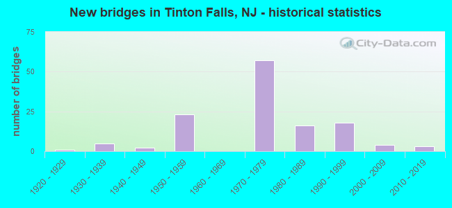
- New bridges - historical statistics
- 11920-1929
- 51930-1939
- 21940-1949
- 231950-1959
- 571970-1979
- 161980-1989
- 181990-1999
- 42000-2009
- 32010-2019

- Reconstructed bridges - Historical Statistics
- 11940-1949
- 11950-1959
- 11960-1969
- 01970-1979
- 61980-1989
- 01990-1999
- 02000-2009
- 12010-2019


- Bridge Condition - Deck
- 5.6%Very good
- 64.8%Good
- 26.8%Satisfactory
- 1.4%Fair
- 1.4%Poor

- Bridge Condition - Superstructure
- 12.7%Very good
- 46.5%Good
- 26.8%Satisfactory
- 11.3%Fair
- 2.8%Poor

- Bridge Condition - Substructure
- 2.8%Very good
- 69.0%Good
- 26.8%Satisfactory
- 1.4%Fair

- Bridge Condition - Channel
- 5.3%Very good
- 36.8%Good
- 42.1%Satisfactory
- 15.8%Fair

- Bridge Condition - Culverts
- 66.7%Good
- 33.3%Fair
Find on map >> Show street view
Structure Number: 361009S, Location: 0.4 mi S. of GSP/33 Jct (Lat: 40.208561, Lng: -74.098469), Route carried "on" structure: Other road GSP, Year Built: 1954, Year Reconstructed: 1985, Status: Open, Structure Length: 3.35m (10.99ft), Average Daily Traffic: 69,928 (year 2020), Truck Traffic: 3%, Average Future Daily Traffic: 83,914 (year 2040), Design Load: HS 20+Mod, Features Intersected: SHARK RIVER
Minimum Vertical Clearance: 30+ m (98+ ft), Kilometerpoint: 162.286, Lanes on structure: 5, Base Highway Network: Yes, Toll: On toll road, Owner: State Toll Authority, Approaching Roadway Width: 25.6m (84.0ft), Skew: 1 degrees, Material/Design: Steel, Design/Construction: Stringer/Multi-beam, Number Of Spans In Main Unit: 3, Length of Maximum Span: 12.8m (42.0ft), Curb-To-Curb Width: 25.7m (84.3ft), Out-to-Out Width: 26.8m (87.9ft)
Condition: Deck: Satisfactory, Superstructure: Good, Substructure: Good, Channel: Satisfactory, Operating Rating: 38.6 metric tons, Method Used To Determine Operating Rating: Load and Resistance Factor Rating (LRFR) rating reported by rating factor(RF) method using HL-93 loadings, Inventory Rating: 29.8 metric tons, Method Used To Determine Inventory Rating: Load and Resistance Factor Rating (LRFR) rating reported by rating factor(RF) method using HL-93 loadings, Structural Evaluation: Better than present minimum criteria, Deck Geometry: Better than present minimum criteria, Waterway Adequacy: Equal to present desirable criteria, Approach Roadway Alignment: Equal to present desirable criteria, Designated Inspection Frequency: Every 24 months, Inspection Date: May 2020, Deck Structure Type: Concrete Cast-file-Place, Wearing Surface/Protective System: Wearing Surface: Monolithic Concrete, Deck Protection: Epoxy Coated Reinforcing
Find on map >> Show street view
Structure Number: 361013N, Location: 0.31 MI S OF GSP&RT66 JCT (Lat: 40.213419, Lng: -74.097433), Route carried "on" structure: State highway 33, Year Built: 1986, Status: Open, Structure Length: 5.58m (18.31ft), Average Daily Traffic: 22,017 (year 2020), Truck Traffic: 4%, Average Future Daily Traffic: 26,420 (year 2040), Design Load: HS 20+Mod, Features Intersected: GSP NB
Minimum Vertical Clearance: 30+ m (98+ ft), Kilometerpoint: 60.479, Lanes on structure: 5, Lanes under structure: 5, Base Highway Network: Yes, Owner: State Toll Authority, Approaching Roadway Width: 25.9m (85.0ft), Skew: 23 degrees, Material/Design: Steel, Design/Construction: Stringer/Multi-beam, Number Of Spans In Main Unit: 1, Length of Maximum Span: 53.6m (175.9ft), Curb or Sidewalk Widths: Left: 0.0m, Right: 1.8m (5.9ft), Curb-To-Curb Width: 25.0m (82.0ft), Out-to-Out Width: 28.4m (93.2ft)
Condition: Deck: Good, Superstructure: Good, Substructure: Good, Operating Rating: 96.9 metric tons, Method Used To Determine Operating Rating: Load and Resistance Factor Rating (LRFR) rating reported by rating factor(RF) method using HL-93 loadings, Inventory Rating: 92.7 metric tons, Method Used To Determine Inventory Rating: Load and Resistance Factor Rating (LRFR) rating reported by rating factor(RF) method using HL-93 loadings, Structural Evaluation: Better than present minimum criteria, Deck Geometry: Superior to present desirable criteria, Underclear: Somewhat better than minimum adequacy, Approach Roadway Alignment: Better than present minimum criteria, Designated Inspection Frequency: Every 24 months, Inspection Date: May 2020, Deck Structure Type: Concrete Cast-file-Place, Wearing Surface/Protective System: Wearing Surface: Monolithic Concrete, Deck Protection: Epoxy Coated Reinforcing
Find on map >> Show street view
Structure Number: 361013S, Location: 0.31 MI S OF GSP&RT66 JCT (Lat: 40.214339, Lng: -74.099956), Route carried "on" structure: State highway 33, Year Built: 1986, Status: Open, Structure Length: 6.04m (19.82ft), Average Daily Traffic: 24,333 (year 2020), Truck Traffic: 4%, Average Future Daily Traffic: 29,199 (year 2040), Design Load: HS 20+Mod, Features Intersected: GSP SB
Minimum Vertical Clearance: 30+ m (98+ ft), Kilometerpoint: 60.302, Lanes on structure: 5, Lanes under structure: 5, Base Highway Network: Yes, Owner: State Toll Authority, Approaching Roadway Width: 25.9m (85.0ft), Skew: 24 degrees, Material/Design: Steel, Design/Construction: Stringer/Multi-beam, Number Of Spans In Main Unit: 1, Length of Maximum Span: 57.9m (190.0ft), Curb or Sidewalk Widths: Left: 0.0m, Right: 1.8m (5.9ft), Curb-To-Curb Width: 25.0m (82.0ft), Out-to-Out Width: 28.4m (93.2ft)
Condition: Deck: Good, Superstructure: Good, Substructure: Good, Operating Rating: 87.5 metric tons, Method Used To Determine Operating Rating: Load and Resistance Factor Rating (LRFR) rating reported by rating factor(RF) method using HL-93 loadings, Inventory Rating: 67.4 metric tons, Method Used To Determine Inventory Rating: Load and Resistance Factor Rating (LRFR) rating reported by rating factor(RF) method using HL-93 loadings, Structural Evaluation: Better than present minimum criteria, Deck Geometry: Superior to present desirable criteria, Underclear: Somewhat better than minimum adequacy, Approach Roadway Alignment: Better than present minimum criteria, Designated Inspection Frequency: Every 24 months, Inspection Date: May 2020, Deck Structure Type: Concrete Cast-file-Place, Wearing Surface/Protective System: Wearing Surface: Monolithic Concrete, Deck Protection: Epoxy Coated Reinforcing
Find on map >> Show street view
Structure Number: 361015S, Location: 0.24 MI N OF GSP&RT33 JCT (Lat: 40.217881, Lng: -74.099200), Route carried "on" structure: Alternate State highway 66, Year Built: 1986, Status: Open, Structure Length: 5.33m (17.49ft), Average Daily Traffic: 30,697 (year 2020), Truck Traffic: 4%, Average Future Daily Traffic: 33,053 (year 2040), Design Load: HS 20+Mod, Features Intersected: GSP SB
Minimum Vertical Clearance: 30+ m (98+ ft), Kilometerpoint: 0.386, Lanes on structure: 3, Lanes under structure: 5, Base Highway Network: Yes, Owner: State Toll Authority, Approaching Roadway Width: 14.6m (47.9ft), Skew: 23 degrees, Material/Design: Steel, Design/Construction: Stringer/Multi-beam, Number Of Spans In Main Unit: 1, Length of Maximum Span: 51.2m (168.0ft), Curb or Sidewalk Widths: Left: 1.8m (5.9ft), Right: 0.0m, Curb-To-Curb Width: 14.6m (47.9ft), Out-to-Out Width: 17.3m (56.8ft)
Condition: Deck: Good, Superstructure: Good, Substructure: Good, Operating Rating: 96.9 metric tons, Method Used To Determine Operating Rating: Load and Resistance Factor Rating (LRFR) rating reported by rating factor(RF) method using HL-93 loadings, Inventory Rating: 82.0 metric tons, Method Used To Determine Inventory Rating: Load and Resistance Factor Rating (LRFR) rating reported by rating factor(RF) method using HL-93 loadings, Structural Evaluation: Better than present minimum criteria, Deck Geometry: Somewhat better than minimum adequacy, Underclear: Somewhat better than minimum adequacy, Approach Roadway Alignment: Better than present minimum criteria, Designated Inspection Frequency: Every 24 months, Inspection Date: May 2020, Deck Structure Type: Concrete Cast-file-Place, Wearing Surface/Protective System: Wearing Surface: Monolithic Concrete, Deck Protection: Epoxy Coated Reinforcing
Find on map >> Show street view
Structure Number: 361016N, Location: 0.34 MI N OF GSP&RT33 JCT (Lat: 40.218647, Lng: -74.097525), Route carried "on" structure: State highway 66, Year Built: 1986, Status: Open, Structure Length: 5.43m (17.81ft), Average Daily Traffic: 30,696 (year 2020), Truck Traffic: 4%, Average Future Daily Traffic: 33,052 (year 2040), Design Load: HS 20+Mod, Features Intersected: GSP NB
Minimum Vertical Clearance: 30+ m (98+ ft), Kilometerpoint: 0.547, Lanes on structure: 3, Lanes under structure: 5, Base Highway Network: Yes, Owner: State Toll Authority, Approaching Roadway Width: 14.6m (47.9ft), Skew: 3 degrees, Material/Design: Steel, Design/Construction: Stringer/Multi-beam, Number Of Spans In Main Unit: 1, Length of Maximum Span: 52.1m (170.9ft), Curb or Sidewalk Widths: Left: 1.8m (5.9ft), Right: 0.0m, Curb-To-Curb Width: 14.6m (47.9ft), Out-to-Out Width: 17.3m (56.8ft)
Condition: Deck: Good, Superstructure: Good, Substructure: Good, Operating Rating: 96.9 metric tons, Method Used To Determine Operating Rating: Load and Resistance Factor Rating (LRFR) rating reported by rating factor(RF) method using HL-93 loadings, Inventory Rating: 79.4 metric tons, Method Used To Determine Inventory Rating: Load and Resistance Factor Rating (LRFR) rating reported by rating factor(RF) method using HL-93 loadings, Structural Evaluation: Better than present minimum criteria, Deck Geometry: Somewhat better than minimum adequacy, Underclear: Somewhat better than minimum adequacy, Approach Roadway Alignment: Better than present minimum criteria, Designated Inspection Frequency: Every 24 months, Inspection Date: May 2020, Deck Structure Type: Concrete Cast-file-Place, Wearing Surface/Protective System: Wearing Surface: Monolithic Concrete, Deck Protection: Epoxy Coated Reinforcing
Find on map >> Show street view
Structure Number: 361032N, Location: 1.55 mi N. of GSP&66 Jct. (Lat: 40.239581, Lng: -74.087075), Route carried "on" structure: Other road GSP, Year Built: 1986, Status: Open, Structure Length: 2.59m (8.50ft), Average Daily Traffic: 83,538 (year 2020), Truck Traffic: 3%, Average Future Daily Traffic: 100,980 (year 2040), Design Load: HS 20+Mod, Features Intersected: ASBURY AVENUE (CR 16), Facility Carried by Structure: PARKWAY N
Minimum Vertical Clearance: 30+ m (98+ ft), Kilometerpoint: 166.004, Lanes on structure: 4, Lanes under structure: 2, Base Highway Network: Yes, Toll: On toll road, Owner: State Toll Authority, Approaching Roadway Width: 25.9m (85.0ft), Material/Design: Prestressed concrete, Design/Construction: Box Beam or Girders - Multiple, Number Of Spans In Main Unit: 1, Length of Maximum Span: 24.4m (80.1ft), Curb-To-Curb Width: 25.8m (84.6ft), Out-to-Out Width: 26.8m (87.9ft)
Condition: Deck: Good, Superstructure: Satisfactory, Substructure: Good, Operating Rating: 34.3 metric tons, Method Used To Determine Operating Rating: Load and Resistance Factor Rating (LRFR) rating reported by rating factor(RF) method using HL-93 loadings, Inventory Rating: 25.9 metric tons, Method Used To Determine Inventory Rating: Load and Resistance Factor Rating (LRFR) rating reported by rating factor(RF) method using HL-93 loadings, Structural Evaluation: Equal to present minimum criteria, Deck Geometry: Superior to present desirable criteria, Underclear: Equal to present minimum criteria, Approach Roadway Alignment: Better than present minimum criteria, Designated Inspection Frequency: Every 24 months, Inspection Date: June 2020, Deck Structure Type: Concrete Cast-file-Place, Wearing Surface/Protective System: Wearing Surface: Monolithic Concrete, Deck Protection: Epoxy Coated Reinforcing
Find on map >> Show street view
Structure Number: 361032S, Location: 1.55 mi N. of GSP&66 Jct. (Lat: 40.240283, Lng: -74.088106), Route carried "on" structure: Other road GSP, Year Built: 1983, Status: Open, Structure Length: 2.59m (8.50ft), Average Daily Traffic: 83,538 (year 2020), Truck Traffic: 3%, Average Future Daily Traffic: 100,980 (year 2040), Design Load: HS 20+Mod, Features Intersected: ASBURY AVENUE (CR 16), Facility Carried by Structure: PARKWAY S
Minimum Vertical Clearance: 30+ m (98+ ft), Kilometerpoint: 166.004, Lanes on structure: 5, Lanes under structure: 2, Base Highway Network: Yes, Toll: On toll road, Owner: State Toll Authority, Approaching Roadway Width: 23.8m (78.1ft), Material/Design: Prestressed concrete, Design/Construction: Box Beam or Girders - Multiple, Number Of Spans In Main Unit: 1, Length of Maximum Span: 24.4m (80.1ft), Curb-To-Curb Width: 23.5m (77.1ft), Out-to-Out Width: 24.4m (80.1ft)
Condition: Deck: Good, Superstructure: Satisfactory, Substructure: Satisfactory, Operating Rating: 26.2 metric tons, Method Used To Determine Operating Rating: Load and Resistance Factor Rating (LRFR) rating reported by rating factor(RF) method using HL-93 loadings, Inventory Rating: 19.8 metric tons, Method Used To Determine Inventory Rating: Load and Resistance Factor Rating (LRFR) rating reported by rating factor(RF) method using HL-93 loadings, Structural Evaluation: Somewhat better than minimum adequacy, Deck Geometry: Equal to present minimum criteria, Underclear: Somewhat better than minimum adequacy, Approach Roadway Alignment: Better than present minimum criteria, Designated Inspection Frequency: Every 24 months, Inspection Date: June 2020, Deck Structure Type: Concrete Cast-file-Place, Wearing Surface/Protective System: Wearing Surface: Monolithic Concrete, Deck Protection: Epoxy Coated Reinforcing
Find on map >> Show street view
Structure Number: 361045E, Location: 1.57 mi. S. of 18&GSP Jct (Lat: 40.258550, Lng: -74.081161), Route carried "on" structure: Other road GSP, Year Built: 1972, Status: Open, Structure Length: 3.26m (10.70ft), Average Daily Traffic: 29,621 (year 2020), Truck Traffic: 3%, Average Future Daily Traffic: 36,139 (year 2040), Design Load: H 20, Features Intersected: WEST PARK AVENUE, Facility Carried by Structure: PARKWAY SBI
Minimum Vertical Clearance: 30+ m (98+ ft), Kilometerpoint: 168.257, Lanes on structure: 2, Lanes under structure: 2, Base Highway Network: Yes, Toll: On toll road, Owner: State Toll Authority, Approaching Roadway Width: 12.2m (40.0ft), Skew: 1 degrees, Material/Design: Prestressed concrete, Design/Construction: Box Beam or Girders - Multiple, Number Of Spans In Main Unit: 3, Length of Maximum Span: 12.8m (42.0ft), Curb-To-Curb Width: 11.4m (37.4ft), Out-to-Out Width: 12.3m (40.4ft)
Condition: Deck: Good, Superstructure: Satisfactory, Substructure: Good, Operating Rating: 34.3 metric tons, Method Used To Determine Operating Rating: Load and Resistance Factor Rating (LRFR) rating reported by rating factor(RF) method using HL-93 loadings, Inventory Rating: 21.7 metric tons, Method Used To Determine Inventory Rating: Load and Resistance Factor Rating (LRFR) rating reported by rating factor(RF) method using HL-93 loadings, Structural Evaluation: Somewhat better than minimum adequacy, Deck Geometry: Somewhat better than minimum adequacy, Underclear: Meets minimum limits, Approach Roadway Alignment: Better than present minimum criteria, Designated Inspection Frequency: Every 24 months, Inspection Date: June 2020, Deck Structure Type: Concrete Cast-file-Place, Wearing Surface/Protective System: Wearing Surface: Bituminous, Membrane: Other
Find on map >> Show street view
Structure Number: 361045I, Location: 1.57 MI S OF 18 S GSP JCT (Lat: 40.258750, Lng: -74.079619), Route carried "on" structure: Other road GSP, Year Built: 1972, Status: Open, Structure Length: 3.23m (10.60ft), Average Daily Traffic: 31,620 (year 2020), Truck Traffic: 3%, Average Future Daily Traffic: 38,556 (year 2040), Design Load: H 20, Features Intersected: WEST PARK AVENUE
Minimum Vertical Clearance: 30+ m (98+ ft), Kilometerpoint: 168.257, Lanes on structure: 2, Lanes under structure: 2, Base Highway Network: Yes, Toll: On toll road, Owner: State Toll Authority, Approaching Roadway Width: 12.2m (40.0ft), Skew: 1 degrees, Material/Design: Prestressed concrete, Design/Construction: Box Beam or Girders - Single/Spread, Number Of Spans In Main Unit: 3, Length of Maximum Span: 13.1m (43.0ft), Curb-To-Curb Width: 11.4m (37.4ft), Out-to-Out Width: 12.3m (40.4ft)
Condition: Deck: Good, Superstructure: Satisfactory, Substructure: Good, Operating Rating: 34.7 metric tons, Method Used To Determine Operating Rating: Load and Resistance Factor Rating (LRFR) rating reported by rating factor(RF) method using HL-93 loadings, Inventory Rating: 21.4 metric tons, Method Used To Determine Inventory Rating: Load and Resistance Factor Rating (LRFR) rating reported by rating factor(RF) method using HL-93 loadings, Structural Evaluation: Somewhat better than minimum adequacy, Deck Geometry: Somewhat better than minimum adequacy, Underclear: Meets minimum limits, Approach Roadway Alignment: Better than present minimum criteria, Designated Inspection Frequency: Every 24 months, Inspection Date: June 2020, Deck Structure Type: Concrete Cast-file-Place, Wearing Surface/Protective System: Wearing Surface: Bituminous, Membrane: Other
Find on map >> Show street view
Structure Number: 361045O, Location: 1.5 mi S. of 18S&GSP Jct (Lat: 40.258789, Lng: -74.079389), Route carried "on" structure: Other road GSP, Year Built: 1954, Status: Open, Structure Length: 3.23m (10.60ft), Average Daily Traffic: 47,201 (year 2020), Truck Traffic: 3%, Average Future Daily Traffic: 57,579 (year 2040), Design Load: H 20, Features Intersected: WEST PARK AVENUE, Facility Carried by Structure: PAARKWAY NBO
Minimum Vertical Clearance: 30+ m (98+ ft), Kilometerpoint: 168.241, Lanes on structure: 3, Lanes under structure: 2, Base Highway Network: Yes, Toll: On toll road, Owner: State Toll Authority, Approaching Roadway Width: 14.0m (45.9ft), Skew: 1 degrees, Material/Design: Steel, Design/Construction: Stringer/Multi-beam, Number Of Spans In Main Unit: 3, Length of Maximum Span: 13.1m (43.0ft), Curb-To-Curb Width: 14.1m (46.3ft), Out-to-Out Width: 15.2m (49.9ft)
Condition: Deck: Satisfactory, Superstructure: Fair, Substructure: Satisfactory, Operating Rating: 31.1 metric tons, Method Used To Determine Operating Rating: Load and Resistance Factor Rating (LRFR) rating reported by rating factor(RF) method using HL-93 loadings, Inventory Rating: 24.0 metric tons, Method Used To Determine Inventory Rating: Load and Resistance Factor Rating (LRFR) rating reported by rating factor(RF) method using HL-93 loadings, Structural Evaluation: Somewhat better than minimum adequacy, Deck Geometry: Meets minimum limits, Underclear: Meets minimum limits, Approach Roadway Alignment: Better than present minimum criteria, Designated Inspection Frequency: Every 24 months, Inspection Date: June 2020, Deck Structure Type: Concrete Cast-file-Place, Wearing Surface/Protective System: Wearing Surface: Bituminous
Find on map >> Show street view
Structure Number: 361045U, Location: 1.75 MJ S OF NJ36&GSP JCT (Lat: 40.258531, Lng: -74.081411), Route carried "on" structure: Other road GSP, Year Built: 1954, Status: Open, Structure Length: 3.35m (10.99ft), Average Daily Traffic: 46,691 (year 2020), Truck Traffic: 3%, Average Future Daily Traffic: 56,967 (year 2040), Design Load: H 20, Features Intersected: WEST PARK AVENUE, Facility Carried by Structure: Parkway SBO
Minimum Vertical Clearance: 30+ m (98+ ft), Kilometerpoint: 168.241, Lanes on structure: 3, Lanes under structure: 2, Base Highway Network: Yes, Toll: On toll road, Owner: State Toll Authority, Approaching Roadway Width: 14.0m (45.9ft), Skew: 1 degrees, Material/Design: Steel, Design/Construction: Stringer/Multi-beam, Number Of Spans In Main Unit: 3, Length of Maximum Span: 13.4m (44.0ft), Curb-To-Curb Width: 14.1m (46.3ft), Out-to-Out Width: 15.2m (49.9ft)
Condition: Deck: Satisfactory, Superstructure: Satisfactory, Substructure: Satisfactory, Operating Rating: 40.2 metric tons, Method Used To Determine Operating Rating: Load and Resistance Factor Rating (LRFR) rating reported by rating factor(RF) method using HL-93 loadings, Inventory Rating: 31.4 metric tons, Method Used To Determine Inventory Rating: Load and Resistance Factor Rating (LRFR) rating reported by rating factor(RF) method using HL-93 loadings, Structural Evaluation: Equal to present minimum criteria, Deck Geometry: Meets minimum limits, Underclear: Meets minimum limits, Approach Roadway Alignment: Better than present minimum criteria, Designated Inspection Frequency: Every 24 months, Inspection Date: June 2020, Deck Structure Type: Concrete Cast-file-Place, Wearing Surface/Protective System: Wearing Surface: Bituminous
Find on map >> Show street view
Structure Number: 361054E, Location: 0.56 mi S of 18 & GSP Jct (Lat: 40.271781, Lng: -74.079531), Route carried "on" structure: Other road GSP, Year Built: 1975, Status: Open, Structure Length: 3.57m (11.71ft), Average Daily Traffic: 29,601 (year 2020), Truck Traffic: 5%, Average Future Daily Traffic: 36,113 (year 2040), Design Load: H 20, Features Intersected: SHAFTO ROAD (CR 547), Facility Carried by Structure: PARKWAY SBI
Minimum Vertical Clearance: 30+ m (98+ ft), Kilometerpoint: 169.625, Lanes on structure: 2, Lanes under structure: 4, Base Highway Network: Yes, Toll: On toll road, Owner: State Toll Authority, Approaching Roadway Width: 11.6m (38.1ft), Skew: 1 degrees, Material/Design: Prestressed concrete, Design/Construction: Box Beam or Girders - Single/Spread, Number Of Spans In Main Unit: 3, Length of Maximum Span: 17.7m (58.1ft), Curb-To-Curb Width: 11.4m (37.4ft), Out-to-Out Width: 12.3m (40.4ft)
Condition: Deck: Good, Superstructure: Good, Substructure: Good, Operating Rating: 36.6 metric tons, Method Used To Determine Operating Rating: Load and Resistance Factor Rating (LRFR) rating reported by rating factor(RF) method using HL-93 loadings, Inventory Rating: 27.2 metric tons, Method Used To Determine Inventory Rating: Load and Resistance Factor Rating (LRFR) rating reported by rating factor(RF) method using HL-93 loadings, Structural Evaluation: Equal to present minimum criteria, Deck Geometry: Somewhat better than minimum adequacy, Underclear: High priority of corrective action, Approach Roadway Alignment: Equal to present desirable criteria, Length Of Structure Improvement: 4.45m (14.60ft), Designated Inspection Frequency: Every 24 months, Inspection Date: May 2020, Bridge Improvement Cost: $1,536,000, Roadway Improvement Cost: $231,000, Total Project Cost: $1,996,000 ( Estimate for 2018), Deck Structure Type: Concrete Cast-file-Place, Wearing Surface/Protective System: Wearing Surface: Bituminous, Membrane: Preformed Fabric
Find on map >> Show street view
Structure Number: 361054U, Location: 0.61 MI S OF RT18S&GSP JC (Lat: 40.271722, Lng: -74.079756), Route carried "on" structure: Other road GSP, Year Built: 1954, Status: Open, Structure Length: 1.62m (5.31ft), Average Daily Traffic: 45,154 (year 2018), Truck Traffic: 5%, Average Future Daily Traffic: 55,088 (year 2038), Design Load: H 20, Features Intersected: SHAFTO ROAD (CR 547), Facility Carried by Structure: Parkway SBO
Minimum Vertical Clearance: 30+ m (98+ ft), Kilometerpoint: 169.625, Lanes on structure: 3, Lanes under structure: 4, Base Highway Network: Yes, Toll: On toll road, Owner: State Toll Authority, Approaching Roadway Width: 14.0m (45.9ft), Skew: 1 degrees, Material/Design: Concrete, Design/Construction: Frame, Number Of Spans In Main Unit: 1, Length of Maximum Span: 15.5m (50.9ft), Curb-To-Curb Width: 14.0m (45.9ft), Out-to-Out Width: 15.1m (49.5ft)
Condition: Deck: Good, Superstructure: Good, Substructure: Satisfactory, Operating Rating: 45.7 metric tons, Method Used To Determine Operating Rating: Load and Resistance Factor Rating (LRFR) rating reported by rating factor(RF) method using HL-93 loadings, Inventory Rating: 35.3 metric tons, Method Used To Determine Inventory Rating: Load and Resistance Factor Rating (LRFR) rating reported by rating factor(RF) method using HL-93 loadings, Structural Evaluation: Equal to present minimum criteria, Deck Geometry: Meets minimum limits, Underclear: High priority of corrective action, Approach Roadway Alignment: Superior to present desirable criteria, Length Of Structure Improvement: 2.44m (8.01ft), Designated Inspection Frequency: Every 24 months, Inspection Date: May 2020, Bridge Improvement Cost: $1,082,000, Roadway Improvement Cost: $168,000, Total Project Cost: $1,407,000 ( Estimate for 2016), Deck Structure Type: Concrete Cast-file-Place, Wearing Surface/Protective System: Wearing Surface: Bituminous
Find on map >> Show street view
Structure Number: 361055I, Location: 0.5 mi. S. of 18&GSP Jct. (Lat: 40.272153, Lng: -74.078692), Route carried "on" structure: Other road GSP, Year Built: 1972, Status: Open, Structure Length: 3.66m (12.01ft), Average Daily Traffic: 28,083 (year 2018), Truck Traffic: 5%, Average Future Daily Traffic: 34,266 (year 2040), Design Load: H 20, Features Intersected: SHAFTO ROAD (CR 547), Facility Carried by Structure: PARKWAY NBI
Minimum Vertical Clearance: 30+ m (98+ ft), Kilometerpoint: 169.786, Lanes on structure: 2, Lanes under structure: 4, Base Highway Network: Yes, Toll: On toll road, Owner: State Toll Authority, Approaching Roadway Width: 11.6m (38.1ft), Skew: 1 degrees, Material/Design: Prestressed concrete, Design/Construction: Box Beam or Girders - Multiple, Number Of Spans In Main Unit: 3, Length of Maximum Span: 17.7m (58.1ft), Curb-To-Curb Width: 11.4m (37.4ft), Out-to-Out Width: 12.3m (40.4ft)
Condition: Deck: Good, Superstructure: Satisfactory, Substructure: Good, Operating Rating: 41.1 metric tons, Method Used To Determine Operating Rating: Load and Resistance Factor Rating (LRFR) rating reported by rating factor(RF) method using HL-93 loadings, Inventory Rating: 26.9 metric tons, Method Used To Determine Inventory Rating: Load and Resistance Factor Rating (LRFR) rating reported by rating factor(RF) method using HL-93 loadings, Structural Evaluation: Equal to present minimum criteria, Deck Geometry: Somewhat better than minimum adequacy, Underclear: High priority of corrective action, Approach Roadway Alignment: Better than present minimum criteria, Length Of Structure Improvement: 4.57m (14.99ft), Designated Inspection Frequency: Every 24 months, Inspection Date: May 2020, Bridge Improvement Cost: $1,552,000, Roadway Improvement Cost: $233,000, Total Project Cost: $2,018,000 ( Estimate for 2018), Deck Structure Type: Concrete Cast-file-Place, Wearing Surface/Protective System: Wearing Surface: Bituminous
Find on map >> Show street view
Structure Number: 361055O, Location: 0.50 MI S OF 18&GSP JCT (Lat: 40.272400, Lng: -74.078528), Route carried "on" structure: Other road GSP, Year Built: 1953, Status: Open, Structure Length: 1.62m (5.31ft), Average Daily Traffic: 45,272 (year 2020), Truck Traffic: 5%, Average Future Daily Traffic: 55,240 (year 2040), Design Load: H 20, Features Intersected: SHAFTO ROAD (CR 547), Facility Carried by Structure: PARKWAY NBO
Minimum Vertical Clearance: 30+ m (98+ ft), Kilometerpoint: 169.786, Lanes on structure: 3, Lanes under structure: 4, Base Highway Network: Yes, Toll: On toll road, Owner: State Toll Authority, Approaching Roadway Width: 14.0m (45.9ft), Skew: 1 degrees, Material/Design: Concrete, Design/Construction: Frame, Number Of Spans In Main Unit: 1, Length of Maximum Span: 15.2m (49.9ft), Curb-To-Curb Width: 14.0m (45.9ft), Out-to-Out Width: 15.1m (49.5ft)
Condition: Deck: Good, Superstructure: Good, Substructure: Good, Operating Rating: 48.3 metric tons, Method Used To Determine Operating Rating: Load and Resistance Factor Rating (LRFR) rating reported by rating factor(RF) method using HL-93 loadings, Inventory Rating: 37.3 metric tons, Method Used To Determine Inventory Rating: Load and Resistance Factor Rating (LRFR) rating reported by rating factor(RF) method using HL-93 loadings, Structural Evaluation: Better than present minimum criteria, Deck Geometry: Meets minimum limits, Underclear: High priority of corrective action, Approach Roadway Alignment: Better than present minimum criteria, Length Of Structure Improvement: 2.44m (8.01ft), Designated Inspection Frequency: Every 24 months, Inspection Date: May 2020, Bridge Improvement Cost: $1,021,000, Roadway Improvement Cost: $158,000, Total Project Cost: $1,327,000 ( Estimate for 2018), Deck Structure Type: Concrete Cast-file-Place, Wearing Surface/Protective System: Wearing Surface: Bituminous
Find on map >> Show street view
Structure Number: 361063T, Location: GSP INTERCHANGE 105 (Lat: 40.283333, Lng: -74.086261), Route carried "on" structure: Ramp Other road GSP, Year Built: 1975, Status: Open, Structure Length: 11.06m (36.29ft), Average Daily Traffic: 7,028 (year 2020), Truck Traffic: 1%, Average Future Daily Traffic: 8,568 (year 2040), Design Load: H 20, Features Intersected: GSP NBI & SBI, Facility Carried by Structure: SB ENTR RAMP E1
Minimum Vertical Clearance: 30+ m (98+ ft), Kilometerpoint: 171.218, Lanes on structure: 1, Lanes under structure: 4, Toll: On toll road, Owner: State Toll Authority, Approaching Roadway Width: 5.8m (19.0ft), Skew: 9 degrees, Material/Design: Prestressed concrete, Design/Construction: Box Beam or Girders - Multiple, Number Of Spans In Main Unit: 6, Length of Maximum Span: 26.5m (86.9ft), Curb-To-Curb Width: 5.8m (19.0ft), Out-to-Out Width: 6.7m (22.0ft)
Condition: Deck: Good, Superstructure: Satisfactory, Substructure: Satisfactory, Operating Rating: 35.0 metric tons, Method Used To Determine Operating Rating: Load and Resistance Factor Rating (LRFR) rating reported by rating factor(RF) method using HL-93 loadings, Inventory Rating: 20.4 metric tons, Method Used To Determine Inventory Rating: Load and Resistance Factor Rating (LRFR) rating reported by rating factor(RF) method using HL-93 loadings, Structural Evaluation: Somewhat better than minimum adequacy, Deck Geometry: Meets minimum limits, Underclear: High priority of corrective action, Approach Roadway Alignment: Equal to present minimum criteria, Length Of Structure Improvement: 11.09m (36.38ft), Designated Inspection Frequency: Every 24 months, Inspection Date: June 2020, Bridge Improvement Cost: $1,198,000, Roadway Improvement Cost: $400,000, Total Project Cost: $2,036,000 ( Estimate for 2018), Deck Structure Type: Concrete Cast-file-Place, Wearing Surface/Protective System: Wearing Surface: Bituminous
Find on map >> Show street view
Structure Number: 361064A, Location: GSP INT. 105 AT HOPE ROAD (Lat: 40.283331, Lng: -74.088331), Route carried "on" structure: Ramp Other road GSP, Year Built: 1972, Status: Open, Structure Length: 6.71m (22.01ft), Average Daily Traffic: 7,267 (year 2020), Truck Traffic: 1%, Average Future Daily Traffic: 8,866 (year 2040), Design Load: H 20, Features Intersected: INT.105 NB EXIT RAMP E6, Facility Carried by Structure: SB ENTR RAMP E1
Minimum Vertical Clearance: 30+ m (98+ ft), Kilometerpoint: 171.234, Lanes on structure: 1, Lanes under structure: 2, Toll: On toll road, Owner: State Toll Authority, Approaching Roadway Width: 5.8m (19.0ft), Skew: 6 degrees, Material/Design: Prestressed concrete, Design/Construction: Stringer/Multi-beam, Number Of Spans In Main Unit: 3, Length of Maximum Span: 31.1m (102.0ft), Curb-To-Curb Width: 5.8m (19.0ft), Out-to-Out Width: 6.7m (22.0ft)
Condition: Deck: Good, Superstructure: Satisfactory, Substructure: Satisfactory, Operating Rating: 79.1 metric tons, Method Used To Determine Operating Rating: Load and Resistance Factor Rating (LRFR) rating reported by rating factor(RF) method using HL-93 loadings, Inventory Rating: 30.8 metric tons, Method Used To Determine Inventory Rating: Load and Resistance Factor Rating (LRFR) rating reported by rating factor(RF) method using HL-93 loadings, Structural Evaluation: Equal to present minimum criteria, Deck Geometry: Meets minimum limits, Underclear: High priority of corrective action, Approach Roadway Alignment: Equal to present desirable criteria, Length Of Structure Improvement: 6.71m (22.01ft), Designated Inspection Frequency: Every 24 months, Inspection Date: June 2020, Bridge Improvement Cost: $770,000, Roadway Improvement Cost: $257,000, Total Project Cost: $1,283,000 ( Estimate for 2018), Deck Structure Type: Concrete Cast-file-Place, Wearing Surface/Protective System: Wearing Surface: Bituminous, Membrane: Preformed Fabric
Find on map >> Show street view
Structure Number: 361064O, Location: GSP INTERCHANGE 105 (Lat: 40.283761, Lng: -74.085669), Route carried "on" structure: Ramp Other road GSP, Year Built: 1954, Year Reconstructed: 1959, Status: Open, Structure Length: 1.40m (4.59ft), Average Daily Traffic: 21,440 (year 2020), Truck Traffic: 1%, Average Future Daily Traffic: 26,157 (year 2040), Features Intersected: GSP NBO, Facility Carried by Structure: RAMPS E1 & E2
Minimum Vertical Clearance: 30+ m (98+ ft), Kilometerpoint: 171.234, Lanes on structure: 3, Lanes under structure: 3, Toll: On toll road, Owner: State Toll Authority, Approaching Roadway Width: 15.2m (49.9ft), Skew: 20 degrees, Material/Design: Concrete, Design/Construction: Frame, Number Of Spans In Main Unit: 1, Length of Maximum Span: 14.0m (45.9ft), Curb-To-Curb Width: 14.1m (46.3ft), Out-to-Out Width: 16.3m (53.5ft)
Condition: Deck: Satisfactory, Superstructure: Satisfactory, Substructure: Satisfactory, Operating Rating: 64.2 metric tons, Method Used To Determine Operating Rating: Load and Resistance Factor Rating (LRFR) rating reported by rating factor(RF) method using HL-93 loadings, Inventory Rating: 49.6 metric tons, Method Used To Determine Inventory Rating: Load and Resistance Factor Rating (LRFR) rating reported by rating factor(RF) method using HL-93 loadings, Structural Evaluation: Equal to present minimum criteria, Deck Geometry: Better than present minimum criteria, Underclear: High priority of corrective action, Approach Roadway Alignment: Better than present minimum criteria, Length Of Structure Improvement: 1.65m (5.41ft), Designated Inspection Frequency: Every 24 months, Inspection Date: June 2020, Bridge Improvement Cost: $1,345,000, Roadway Improvement Cost: $135,000, Total Project Cost: $1,800,000 ( Estimate for 2018), Deck Structure Type: Concrete Cast-file-Place, Wearing Surface/Protective System: Wearing Surface: Bituminous
Find on map >> Show street view
Structure Number: 361064T, Location: GSP INT. 105 (Lat: 40.283369, Lng: -74.086869), Route carried "on" structure: Ramp Other road GSP, Year Built: 1972, Status: Open, Structure Length: 9.66m (31.69ft), Average Daily Traffic: 17,429 (year 2020), Truck Traffic: 1%, Average Future Daily Traffic: 20,915 (year 2040), Design Load: H 20, Features Intersected: GSP NBI & SBI
Minimum Vertical Clearance: 30+ m (98+ ft), Kilometerpoint: 171.878, Lanes on structure: 2, Lanes under structure: 4, Toll: On toll road, Owner: State Toll Authority, Approaching Roadway Width: 10.4m (34.1ft), Skew: 19 degrees, Material/Design: Prestressed concrete, Design/Construction: Box Beam or Girders - Multiple, Number Of Spans In Main Unit: 6, Length of Maximum Span: 22.3m (73.2ft), Curb-To-Curb Width: 10.4m (34.1ft), Out-to-Out Width: 11.3m (37.1ft)
Condition: Deck: Good, Superstructure: Good, Substructure: Good, Operating Rating: 41.1 metric tons, Method Used To Determine Operating Rating: Load and Resistance Factor Rating (LRFR) rating reported by rating factor(RF) method using HL-93 loadings, Inventory Rating: 22.7 metric tons, Method Used To Determine Inventory Rating: Load and Resistance Factor Rating (LRFR) rating reported by rating factor(RF) method using HL-93 loadings, Structural Evaluation: Somewhat better than minimum adequacy, Deck Geometry: Better than present minimum criteria, Underclear: High priority of corrective action, Approach Roadway Alignment: Meets minimum limits, Length Of Structure Improvement: 9.66m (31.69ft), Designated Inspection Frequency: Every 24 months, Inspection Date: May 2020, Bridge Improvement Cost: $375,000, Roadway Improvement Cost: $100,000, Total Project Cost: $475,000 ( Estimate for 2018), Deck Structure Type: Concrete Cast-file-Place, Wearing Surface/Protective System: Wearing Surface: Bituminous
Find on map >> Show street view
Structure Number: 361064U, Location: GSP INT. 105 (Lat: 40.283653, Lng: -74.088711), Route carried "on" structure: Ramp Other road GSP, Year Built: 1972, Status: Open, Structure Length: 7.10m (23.29ft), Average Daily Traffic: 11,909 (year 2020), Truck Traffic: 1%, Average Future Daily Traffic: 14,529 (year 2040), Design Load: H 20, Features Intersected: GSP SBO, Facility Carried by Structure: Ramp 105SBOX E2
Minimum Vertical Clearance: 30+ m (98+ ft), Kilometerpoint: 171.234, Lanes on structure: 1, Lanes under structure: 3, Toll: On toll road, Owner: State Toll Authority, Approaching Roadway Width: 5.8m (19.0ft), Skew: 9 degrees, Material/Design: Prestressed concrete, Design/Construction: Stringer/Multi-beam, Number Of Spans In Main Unit: 3, Length of Maximum Span: 35.1m (115.2ft), Curb-To-Curb Width: 5.8m (19.0ft), Out-to-Out Width: 6.7m (22.0ft)
Condition: Deck: Satisfactory, Superstructure: Satisfactory, Substructure: Good, Operating Rating: 48.3 metric tons, Method Used To Determine Operating Rating: Load and Resistance Factor Rating (LRFR) rating reported by rating factor(RF) method using HL-93 loadings, Inventory Rating: 37.3 metric tons, Method Used To Determine Inventory Rating: Load and Resistance Factor Rating (LRFR) rating reported by rating factor(RF) method using HL-93 loadings, Structural Evaluation: Equal to present minimum criteria, Deck Geometry: Meets minimum limits, Underclear: High priority of corrective action, Approach Roadway Alignment: Somewhat better than minimum adequacy, Length Of Structure Improvement: 7.10m (23.29ft), Designated Inspection Frequency: Every 24 months, Inspection Date: June 2020, Bridge Improvement Cost: $384,000, Total Project Cost: $484,000 ( Estimate for 2018), Deck Structure Type: Concrete Cast-file-Place, Wearing Surface/Protective System: Wearing Surface: Bituminous, Membrane: Preformed Fabric
Find on map >> Show street view
Structure Number: 361065O, Location: Parkway Interchange 105 (Lat: 40.284189, Lng: -74.085981), Route carried "on" structure: Ramp Other road GSP, Year Built: 1972, Status: Open, Structure Length: 4.94m (16.21ft), Average Daily Traffic: 28,367 (year 2020), Truck Traffic: 1%, Average Future Daily Traffic: 34,608 (year 2040), Design Load: H 20, Features Intersected: GSP NBO, Facility Carried by Structure: Ramp 105NBIE E7
Minimum Vertical Clearance: 30+ m (98+ ft), Kilometerpoint: 171.395, Lanes on structure: 1, Lanes under structure: 3, Toll: On toll road, Owner: State Toll Authority, Approaching Roadway Width: 5.8m (19.0ft), Skew: 9 degrees, Material/Design: Prestressed concrete, Design/Construction: Box Beam or Girders - Single/Spread, Number Of Spans In Main Unit: 3, Length of Maximum Span: 23.8m (78.1ft), Curb-To-Curb Width: 5.8m (19.0ft), Out-to-Out Width: 6.7m (22.0ft)
Condition: Deck: Good, Superstructure: Satisfactory, Substructure: Good, Operating Rating: 41.5 metric tons, Method Used To Determine Operating Rating: Load and Resistance Factor Rating (LRFR) rating reported by rating factor(RF) method using HL-93 loadings, Inventory Rating: 25.6 metric tons, Method Used To Determine Inventory Rating: Load and Resistance Factor Rating (LRFR) rating reported by rating factor(RF) method using HL-93 loadings, Structural Evaluation: Equal to present minimum criteria, Deck Geometry: Meets minimum limits, Underclear: High priority of corrective action, Approach Roadway Alignment: Meets minimum limits, Length Of Structure Improvement: 4.94m (16.21ft), Designated Inspection Frequency: Every 24 months, Inspection Date: June 2020, Bridge Improvement Cost: $550,000, Total Project Cost: $660,000 ( Estimate for 2018), Deck Structure Type: Concrete Cast-file-Place, Wearing Surface/Protective System: Wearing Surface: Bituminous
Find on map >> Show street view
Structure Number: 361067A, Location: 0.54mi N. of GSP/18 Int. (Lat: 40.287875, Lng: -74.090969), Route carried "on" structure: Ramp Other road GSP, Year Built: 2017, Status: Open, Structure Length: 6.77m (22.21ft), Average Daily Traffic: 52,885 (year 2020), Truck Traffic: 1%, Average Future Daily Traffic: 63,461 (year 2040), Design Load: HL 93, Features Intersected: PINE BROOK RD & CRR-NJ, Facility Carried by Structure: INT. 105 RAMP I
Minimum Vertical Clearance: 30+ m (98+ ft), Kilometerpoint: 171.862, Lanes on structure: 2, Lanes under structure: 2, Toll: On toll road, Owner: State Toll Authority, Approaching Roadway Width: 8.8m (28.9ft), Skew: 2 degrees, Material/Design: Steel continuous, Design/Construction: Stringer/Multi-beam, Number Of Spans In Main Unit: 2, Length of Maximum Span: 34.7m (113.8ft), Curb-To-Curb Width: 8.8m (28.9ft), Out-to-Out Width: 10.0m (32.8ft)
Condition: Deck: Good, Superstructure: Very good, Substructure: Good, Operating Rating: 51.2 metric tons, Method Used To Determine Operating Rating: Load and Resistance Factor Rating (LRFR) rating reported by rating factor(RF) method using HL-93 loadings, Inventory Rating: 39.5 metric tons, Method Used To Determine Inventory Rating: Load and Resistance Factor Rating (LRFR) rating reported by rating factor(RF) method using HL-93 loadings, Structural Evaluation: Better than present minimum criteria, Deck Geometry: Meets minimum limits, Underclear: Meets minimum limits, Approach Roadway Alignment: Equal to present desirable criteria, Designated Inspection Frequency: Every 24 months, Inspection Date: September 2020, Deck Structure Type: Concrete Cast-file-Place, Wearing Surface/Protective System: Deck Protection: Epoxy Coated Reinforcing
Find on map >> Show street view
Structure Number: 361067E, Location: 0.61 mi N of GSP&18 Int. (Lat: 40.288331, Lng: -74.090000), Route carried "on" structure: Other road GSP, Year Built: 1975, Status: Open, Structure Length: 6.37m (20.90ft), Average Daily Traffic: 29,969 (year 2020), Truck Traffic: 1%, Average Future Daily Traffic: 35,963 (year 2040), Design Load: H 20, Features Intersected: PINE BROOK RD & CRR-NJ
Minimum Vertical Clearance: 30+ m (98+ ft), Kilometerpoint: 171.862, Lanes on structure: 3, Lanes under structure: 2, Base Highway Network: Yes, Toll: On toll road, Owner: State Toll Authority, Approaching Roadway Width: 15.2m (49.9ft), Skew: 1 degrees, Material/Design: Prestressed concrete, Design/Construction: Box Beam or Girders - Multiple, Number Of Spans In Main Unit: 4, Length of Maximum Span: 18.9m (62.0ft), Curb-To-Curb Width: 15.4m (50.5ft), Out-to-Out Width: 16.3m (53.5ft)
Condition: Deck: Good, Superstructure: Satisfactory, Substructure: Good, Operating Rating: 37.6 metric tons, Method Used To Determine Operating Rating: Load and Resistance Factor Rating (LRFR) rating reported by rating factor(RF) method using HL-93 loadings, Inventory Rating: 29.2 metric tons, Method Used To Determine Inventory Rating: Load and Resistance Factor Rating (LRFR) rating reported by rating factor(RF) method using HL-93 loadings, Structural Evaluation: Equal to present minimum criteria, Deck Geometry: Somewhat better than minimum adequacy, Underclear: Meets minimum limits, Approach Roadway Alignment: Equal to present desirable criteria, Designated Inspection Frequency: Every 24 months, Inspection Date: June 2020, Deck Structure Type: Concrete Cast-file-Place, Wearing Surface/Protective System: Wearing Surface: Bituminous, Membrane: Other
Find on map >> Show street view
Structure Number: 361067U, Location: 0.61mi N. of GSP/18 Int. (Lat: 40.288000, Lng: -74.091000), Route carried "on" structure: Other road GSP, Year Built: 1953, Year Reconstructed: 1972, Status: Open, Structure Length: 6.64m (21.78ft), Average Daily Traffic: 63,462 (year 2020), Truck Traffic: 1%, Average Future Daily Traffic: 76,153 (year 2040), Design Load: H 20, Features Intersected: PINE BROOK RD & CRR-NJ
Minimum Vertical Clearance: 30+ m (98+ ft), Kilometerpoint: 171.862, Lanes on structure: 3, Lanes under structure: 2, Base Highway Network: Yes, Toll: On toll road, Owner: State Toll Authority, Approaching Roadway Width: 19.5m (64.0ft), Skew: 2 degrees, Material/Design: Steel, Design/Construction: Stringer/Multi-beam, Number Of Spans In Main Unit: 4, Length of Maximum Span: 19.5m (64.0ft), Curb-To-Curb Width: 19.4m (63.6ft), Out-to-Out Width: 20.5m (67.3ft)
Condition: Deck: Satisfactory, Superstructure: Good, Substructure: Good, Operating Rating: 47.0 metric tons, Method Used To Determine Operating Rating: Load and Resistance Factor Rating (LRFR) rating reported by rating factor(RF) method using HL-93 loadings, Inventory Rating: 36.3 metric tons, Method Used To Determine Inventory Rating: Load and Resistance Factor Rating (LRFR) rating reported by rating factor(RF) method using HL-93 loadings, Structural Evaluation: Better than present minimum criteria, Deck Geometry: Superior to present desirable criteria, Underclear: High priority of corrective action, Approach Roadway Alignment: Equal to present desirable criteria, Designated Inspection Frequency: Every 24 months, Inspection Date: June 2020, Deck Structure Type: Concrete Cast-file-Place, Wearing Surface/Protective System: Wearing Surface: Bituminous, Membrane: Preformed Fabric
Find on map >> Show street view
Structure Number: 361068I, Location: 0.61 mi N. of GSP/18 Jnct (Lat: 40.288561, Lng: -74.089669), Route carried "on" structure: Other road GSP, Year Built: 1975, Status: Open, Structure Length: 6.43m (21.10ft), Average Daily Traffic: 38,782 (year 2020), Truck Traffic: 1%, Average Future Daily Traffic: 46,538 (year 2040), Design Load: H 20, Features Intersected: PINE BROOK RD & CRR-NJ, Facility Carried by Structure: PARKWAY NBI
Minimum Vertical Clearance: 30+ m (98+ ft), Kilometerpoint: 171.862, Lanes on structure: 2, Lanes under structure: 2, Base Highway Network: Yes, Toll: On toll road, Owner: State Toll Authority, Approaching Roadway Width: 11.9m (39.0ft), Skew: 1 degrees, Material/Design: Prestressed concrete, Design/Construction: Box Beam or Girders - Multiple, Number Of Spans In Main Unit: 4, Length of Maximum Span: 19.2m (63.0ft), Curb-To-Curb Width: 11.7m (38.4ft), Out-to-Out Width: 12.6m (41.3ft)
Condition: Deck: Good, Superstructure: Satisfactory, Substructure: Good, Operating Rating: 36.9 metric tons, Method Used To Determine Operating Rating: Load and Resistance Factor Rating (LRFR) rating reported by rating factor(RF) method using HL-93 loadings, Inventory Rating: 28.5 metric tons, Method Used To Determine Inventory Rating: Load and Resistance Factor Rating (LRFR) rating reported by rating factor(RF) method using HL-93 loadings, Structural Evaluation: Equal to present minimum criteria, Deck Geometry: Equal to present minimum criteria, Underclear: Somewhat better than minimum adequacy, Approach Roadway Alignment: Equal to present desirable criteria, Designated Inspection Frequency: Every 24 months, Inspection Date: July 2020, Deck Structure Type: Concrete Cast-file-Place, Wearing Surface/Protective System: Wearing Surface: Bituminous, Membrane: Other
Find on map >> Show street view
Structure Number: 361068O, Location: 0.61 mi N. of GSP/18 Juct (Lat: 40.288881, Lng: -74.089161), Route carried "on" structure: Other road GSP, Year Built: 1953, Status: Open, Structure Length: 6.40m (21.00ft), Average Daily Traffic: 56,210 (year 2020), Truck Traffic: 1%, Average Future Daily Traffic: 67,452 (year 2040), Design Load: H 20, Features Intersected: PINE BROOK RD & CRR-NJ, Facility Carried by Structure: PARKWAY NBO
Minimum Vertical Clearance: 30+ m (98+ ft), Kilometerpoint: 171.862, Lanes on structure: 3, Lanes under structure: 2, Base Highway Network: Yes, Toll: On toll road, Owner: State Toll Authority, Approaching Roadway Width: 14.3m (46.9ft), Skew: 1 degrees, Material/Design: Steel, Design/Construction: Stringer/Multi-beam, Number Of Spans In Main Unit: 4, Length of Maximum Span: 18.9m (62.0ft), Curb-To-Curb Width: 14.1m (46.3ft), Out-to-Out Width: 15.2m (49.9ft)
Condition: Deck: Good, Superstructure: Fair, Substructure: Satisfactory, Operating Rating: 48.0 metric tons, Method Used To Determine Operating Rating: Load and Resistance Factor Rating (LRFR) rating reported by rating factor(RF) method using HL-93 loadings, Inventory Rating: 36.9 metric tons, Method Used To Determine Inventory Rating: Load and Resistance Factor Rating (LRFR) rating reported by rating factor(RF) method using HL-93 loadings, Structural Evaluation: Somewhat better than minimum adequacy, Deck Geometry: Meets minimum limits, Underclear: Equal to present minimum criteria, Approach Roadway Alignment: Better than present minimum criteria, Designated Inspection Frequency: Every 24 months, Inspection Date: July 2020, Deck Structure Type: Concrete Cast-file-Place, Wearing Surface/Protective System: Wearing Surface: Bituminous
Find on map >> Show street view
Structure Number: 361075T, Location: 1.37 mi N. of GSP/18 Jct. (Lat: 40.299575, Lng: -74.092594), Route carried "on" structure: County highway 537, Year Built: 1972, Status: Open, Structure Length: 13.62m (44.69ft), Average Daily Traffic: 7,708 (year 2020), Truck Traffic: 4%, Average Future Daily Traffic: 9,405 (year 2040), Design Load: H 20, Features Intersected: GSP
Minimum Vertical Clearance: 30+ m (98+ ft), Kilometerpoint: 101.083, Lanes on structure: 4, Lanes under structure: 10, Owner: State Toll Authority, Approaching Roadway Width: 13.4m (44.0ft), Skew: 1 degrees, Material/Design: Prestressed concrete, Design/Construction: Stringer/Multi-beam, Number Of Spans In Main Unit: 6, Length of Maximum Span: 23.5m (77.1ft), Curb or Sidewalk Widths: Left: 1.5m (4.9ft), Right: 0.9m (3.0ft), Curb-To-Curb Width: 13.4m (44.0ft), Out-to-Out Width: 16.5m (54.1ft)
Condition: Deck: Satisfactory, Superstructure: Good, Substructure: Good, Operating Rating: 34.7 metric tons, Method Used To Determine Operating Rating: Load and Resistance Factor Rating (LRFR) rating reported by rating factor(RF) method using HL-93 loadings, Inventory Rating: 19.4 metric tons, Method Used To Determine Inventory Rating: Load and Resistance Factor Rating (LRFR) rating reported by rating factor(RF) method using HL-93 loadings, Structural Evaluation: Meets minimum limits, Deck Geometry: High priority of replacement, Underclear: High priority of corrective action, Approach Roadway Alignment: Somewhat better than minimum adequacy, Length Of Structure Improvement: 13.72m (45.01ft), Designated Inspection Frequency: Every 24 months, Inspection Date: August 2020, Bridge Improvement Cost: $643,000, Roadway Improvement Cost: $200,000, Total Project Cost: $1,072,000 ( Estimate for 2016), Deck Structure Type: Concrete Cast-file-Place, Wearing Surface/Protective System: Wearing Surface: Monolithic Concrete
Find on map >> Show street view
Structure Number: 361083T, Location: 2.16 mi. N. of 18/GSP jct (Lat: 40.310850, Lng: -74.095131), Route carried "on" structure: County highway 13A, Year Built: 1972, Status: Open, Structure Length: 14.69m (48.20ft), Average Daily Traffic: 16,277 (year 2020), Truck Traffic: 4%, Average Future Daily Traffic: 16,596 (year 2040), Design Load: H 20, Features Intersected: GARDEN STATE PARKWAY
Minimum Vertical Clearance: 30+ m (98+ ft), Kilometerpoint: 0.772, Lanes on structure: 2, Lanes under structure: 10, Owner: State Toll Authority, Approaching Roadway Width: 12.2m (40.0ft), Skew: 3 degrees, Material/Design: Prestressed concrete, Design/Construction: Stringer/Multi-beam, Number Of Spans In Main Unit: 6, Length of Maximum Span: 23.5m (77.1ft), Curb or Sidewalk Widths: Left: 0.9m (3.0ft), Right: 1.5m (4.9ft), Curb-To-Curb Width: 9.1m (29.9ft), Out-to-Out Width: 12.2m (40.0ft)
Condition: Deck: Satisfactory, Superstructure: Good, Substructure: Good, Operating Rating: 29.2 metric tons, Method Used To Determine Operating Rating: Load and Resistance Factor Rating (LRFR) rating reported by rating factor(RF) method using HL-93 loadings, Inventory Rating: 19.1 metric tons, Method Used To Determine Inventory Rating: Load and Resistance Factor Rating (LRFR) rating reported by rating factor(RF) method using HL-93 loadings, Structural Evaluation: Meets minimum limits, Deck Geometry: Meets minimum limits, Underclear: High priority of corrective action, Approach Roadway Alignment: Somewhat better than minimum adequacy, Length Of Structure Improvement: 14.69m (48.20ft), Designated Inspection Frequency: Every 24 months, Inspection Date: August 2020, Bridge Improvement Cost: $500,000, Roadway Improvement Cost: $500,000, Total Project Cost: $1,000,000 ( Estimate for 2016), Deck Structure Type: Concrete Cast-file-Place, Wearing Surface/Protective System: Wearing Surface: Monolithic Concrete
Find on map >> Show street view
Structure Number: 361087E, Location: 2.52 mi. N of GSP/18N Int (Lat: 40.315961, Lng: -74.097611), Route carried "on" structure: Other road GSP, Year Built: 1972, Status: Open, Structure Length: 6.49m (21.29ft), Average Daily Traffic: 25,178 (year 2020), Truck Traffic: 1%, Average Future Daily Traffic: 30,172 (year 2040), Design Load: H 20, Features Intersected: PINE BROOK
Minimum Vertical Clearance: 30+ m (98+ ft), Kilometerpoint: 174.936, Lanes on structure: 2, Base Highway Network: Yes, Toll: On toll road, Owner: State Toll Authority, Approaching Roadway Width: 11.6m (38.1ft), Skew: 1 degrees, Material/Design: Prestressed concrete, Design/Construction: Stringer/Multi-beam, Number Of Spans In Main Unit: 3, Length of Maximum Span: 23.2m (76.1ft), Curb-To-Curb Width: 11.4m (37.4ft), Out-to-Out Width: 12.3m (40.4ft)
Condition: Deck: Satisfactory, Superstructure: Good, Substructure: Good, Channel: Good, Operating Rating: 42.1 metric tons, Method Used To Determine Operating Rating: Load and Resistance Factor Rating (LRFR) rating reported by rating factor(RF) method using HL-93 loadings, Inventory Rating: 23.0 metric tons, Method Used To Determine Inventory Rating: Load and Resistance Factor Rating (LRFR) rating reported by rating factor(RF) method using HL-93 loadings, Structural Evaluation: Somewhat better than minimum adequacy, Deck Geometry: Somewhat better than minimum adequacy, Waterway Adequacy: Better than present minimum criteria, Approach Roadway Alignment: Equal to present desirable criteria, Designated Inspection Frequency: Every 24 months, Inspection Date: September 2020, Deck Structure Type: Concrete Cast-file-Place, Wearing Surface/Protective System: Wearing Surface: Bituminous
Find on map >> Show street view
Structure Number: 361087I, Location: 4.5 MI N OF GSP&RT36 JCT (Lat: 40.316217, Lng: -74.097119), Route carried "on" structure: Other road GSP, Year Built: 1972, Status: Open, Structure Length: 6.31m (20.70ft), Average Daily Traffic: 34,395 (year 2020), Truck Traffic: 1%, Average Future Daily Traffic: 41,304 (year 2040), Design Load: H 20, Features Intersected: PINE BROOK
Minimum Vertical Clearance: 30+ m (98+ ft), Kilometerpoint: 174.936, Lanes on structure: 2, Base Highway Network: Yes, Toll: On toll road, Owner: State Toll Authority, Approaching Roadway Width: 11.3m (37.1ft), Skew: 1 degrees, Material/Design: Prestressed concrete, Design/Construction: Stringer/Multi-beam, Number Of Spans In Main Unit: 3, Length of Maximum Span: 23.2m (76.1ft), Curb-To-Curb Width: 11.4m (37.4ft), Out-to-Out Width: 12.3m (40.4ft)
Condition: Deck: Good, Superstructure: Good, Substructure: Good, Channel: Satisfactory, Operating Rating: 42.8 metric tons, Method Used To Determine Operating Rating: Load and Resistance Factor Rating (LRFR) rating reported by rating factor(RF) method using HL-93 loadings, Inventory Rating: 24.0 metric tons, Method Used To Determine Inventory Rating: Load and Resistance Factor Rating (LRFR) rating reported by rating factor(RF) method using HL-93 loadings, Structural Evaluation: Somewhat better than minimum adequacy, Deck Geometry: Somewhat better than minimum adequacy, Waterway Adequacy: Better than present minimum criteria, Approach Roadway Alignment: Equal to present desirable criteria, Designated Inspection Frequency: Every 24 months, Inspection Date: July 2020, Deck Structure Type: Concrete Cast-file-Place, Wearing Surface/Protective System: Wearing Surface: Bituminous
Find on map >> Show street view
Structure Number: 361087O, Location: 4.5 MI N OF GSP&RT36 JCT (Lat: 40.316197, Lng: -74.096789), Route carried "on" structure: Other road GSP, Year Built: 1954, Status: Open, Structure Length: 6.28m (20.60ft), Average Daily Traffic: 49,628 (year 2018), Truck Traffic: 1%, Average Future Daily Traffic: 59,511 (year 2038), Design Load: H 20, Features Intersected: PINE BROOK
Minimum Vertical Clearance: 30+ m (98+ ft), Kilometerpoint: 174.936, Lanes on structure: 3, Base Highway Network: Yes, Toll: On toll road, Owner: State Toll Authority, Approaching Roadway Width: 14.0m (45.9ft), Skew: 1 degrees, Material/Design: Steel, Design/Construction: Stringer/Multi-beam, Number Of Spans In Main Unit: 3, Length of Maximum Span: 23.2m (76.1ft), Curb-To-Curb Width: 14.3m (46.9ft), Out-to-Out Width: 15.2m (49.9ft)
Condition: Deck: Satisfactory, Superstructure: Fair, Substructure: Good, Channel: Satisfactory, Operating Rating: 54.8 metric tons, Method Used To Determine Operating Rating: Load and Resistance Factor Rating (LRFR) rating reported by rating factor(RF) method using HL-93 loadings, Inventory Rating: 42.1 metric tons, Method Used To Determine Inventory Rating: Load and Resistance Factor Rating (LRFR) rating reported by rating factor(RF) method using HL-93 loadings, Structural Evaluation: Somewhat better than minimum adequacy, Deck Geometry: Meets minimum limits, Waterway Adequacy: Better than present minimum criteria, Approach Roadway Alignment: Equal to present desirable criteria, Designated Inspection Frequency: Every 24 months, Inspection Date: July 2020, Deck Structure Type: Concrete Cast-file-Place, Wearing Surface/Protective System: Wearing Surface: Bituminous, Membrane: Preformed Fabric
Find on map >> Show street view
Structure Number: 361087U, Location: 2.52 mi. N of GSP/18N Jct (Lat: 40.315811, Lng: -74.097889), Route carried "on" structure: Other road GSP, Year Built: 1954, Status: Open, Structure Length: 6.46m (21.19ft), Average Daily Traffic: 59,304 (year 2020), Truck Traffic: 1%, Average Future Daily Traffic: 71,163 (year 2040), Design Load: H 20, Features Intersected: PINE BROOK
Minimum Vertical Clearance: 30+ m (98+ ft), Kilometerpoint: 174.936, Lanes on structure: 3, Base Highway Network: Yes, Toll: On toll road, Owner: State Toll Authority, Approaching Roadway Width: 14.0m (45.9ft), Skew: 1 degrees, Material/Design: Steel, Design/Construction: Stringer/Multi-beam, Number Of Spans In Main Unit: 3, Length of Maximum Span: 23.2m (76.1ft), Curb-To-Curb Width: 14.3m (46.9ft), Out-to-Out Width: 15.2m (49.9ft)
Condition: Deck: Good, Superstructure: Fair, Substructure: Good, Channel: Satisfactory, Operating Rating: 47.3 metric tons, Method Used To Determine Operating Rating: Load and Resistance Factor Rating (LRFR) rating reported by rating factor(RF) method using HL-93 loadings, Inventory Rating: 36.6 metric tons, Method Used To Determine Inventory Rating: Load and Resistance Factor Rating (LRFR) rating reported by rating factor(RF) method using HL-93 loadings, Structural Evaluation: Somewhat better than minimum adequacy, Deck Geometry: Meets minimum limits, Waterway Adequacy: Equal to present minimum criteria, Approach Roadway Alignment: Equal to present desirable criteria, Designated Inspection Frequency: Every 24 months, Inspection Date: September 2020, Deck Structure Type: Concrete Cast-file-Place, Wearing Surface/Protective System: Wearing Surface: Bituminous
Find on map >> Show street view
Structure Number: 361093I, Location: 3.18 MI S of GSP/18 JCT (Lat: 40.324875, Lng: -74.098153), Route carried "on" structure: Other road GSP, Year Built: 1972, Status: Open, Structure Length: 7.71m (25.30ft), Average Daily Traffic: 34,099 (year 2020), Truck Traffic: 1%, Average Future Daily Traffic: 40,912 (year 2040), Design Load: H 20, Features Intersected: SWIMMING RIVER
Minimum Vertical Clearance: 30+ m (98+ ft), Kilometerpoint: 175.901, Lanes on structure: 2, Base Highway Network: Yes, Toll: On toll road, Owner: State Toll Authority, Approaching Roadway Width: 11.6m (38.1ft), Navigation Control: Yes ( Vertical Clearance: 2.4m (7.9ft), Horizontal Clearance: 24.4m (80.1ft)), Material/Design: Prestressed concrete, Design/Construction: Box Beam or Girders - Multiple, Number Of Spans In Main Unit: 4, Length of Maximum Span: 25.3m (83.0ft), Curb-To-Curb Width: 11.4m (37.4ft), Out-to-Out Width: 12.4m (40.7ft)
Condition: Deck: Good, Superstructure: Fair, Substructure: Good, Channel: Good, Operating Rating: 50.2 metric tons, Method Used To Determine Operating Rating: Load and Resistance Factor Rating (LRFR) rating reported by rating factor(RF) method using HL-93 loadings, Inventory Rating: 38.6 metric tons, Method Used To Determine Inventory Rating: Load and Resistance Factor Rating (LRFR) rating reported by rating factor(RF) method using HL-93 loadings, Structural Evaluation: Somewhat better than minimum adequacy, Deck Geometry: Somewhat better than minimum adequacy, Waterway Adequacy: Equal to present desirable criteria, Approach Roadway Alignment: Equal to present desirable criteria, Designated Inspection Frequency: Every 24 months, Inspection Date: September 2020, Deck Structure Type: Concrete Cast-file-Place, Wearing Surface/Protective System: Wearing Surface: Bituminous
Find on map >> Show street view
Structure Number: 361093O, Location: 3.18 mi. N of GSP/18 JCT. (Lat: 40.324881, Lng: -74.097931), Route carried "on" structure: Other road GSP, Year Built: 1954, Status: Open, Structure Length: 7.71m (25.30ft), Average Daily Traffic: 49,654 (year 2020), Truck Traffic: 1%, Average Future Daily Traffic: 59,578 (year 2040), Design Load: H 20, Features Intersected: SWIMMING RIVER
Minimum Vertical Clearance: 30+ m (98+ ft), Kilometerpoint: 175.901, Lanes on structure: 3, Base Highway Network: Yes, Toll: On toll road, Owner: State Toll Authority, Approaching Roadway Width: 14.0m (45.9ft), Navigation Control: Yes ( Vertical Clearance: 2.4m (7.9ft), Horizontal Clearance: 24.4m (80.1ft)), Material/Design: Steel, Design/Construction: Stringer/Multi-beam, Number Of Spans In Main Unit: 4, Length of Maximum Span: 25.3m (83.0ft), Curb-To-Curb Width: 14.1m (46.3ft), Out-to-Out Width: 15.2m (49.9ft)
Condition: Deck: Satisfactory, Superstructure: Fair, Substructure: Good, Channel: Good, Operating Rating: 46.3 metric tons, Method Used To Determine Operating Rating: Load and Resistance Factor Rating (LRFR) rating reported by rating factor(RF) method using HL-93 loadings, Inventory Rating: 35.6 metric tons, Method Used To Determine Inventory Rating: Load and Resistance Factor Rating (LRFR) rating reported by rating factor(RF) method using HL-93 loadings, Structural Evaluation: Somewhat better than minimum adequacy, Deck Geometry: Meets minimum limits, Waterway Adequacy: Equal to present desirable criteria, Approach Roadway Alignment: Equal to present desirable criteria, Designated Inspection Frequency: Every 24 months, Inspection Date: August 2020, Deck Structure Type: Concrete Cast-file-Place, Wearing Surface/Protective System: Wearing Surface: Bituminous
Find on map >> Show street view
Structure Number: 130815, Location: NJ 34 & 33 JCT (Lat: 40.227081, Lng: -74.145431), Route carried "under" structure: State highway 33, Year Built: 1936, Structure Length: 0. m, Average Daily Traffic: 19,427 (year 2020), Truck Traffic: 4%, Features Intersected: NJ 33 WB, Facility Carried by Structure: NJ 34 SB
Minimum Vertical Clearance: 4.29m (14.07ft), Kilometerpoint: 55.957, Lanes on structure: 1, Lanes under structure: 1, Material/Design: Steel, Design/Construction: Stringer/Multi-beam, Length of Maximum Span: 9.8m (32.2ft)
Find on map >> Show street view
Structure Number: 1308156, Location: 0.94 MI S OF RTE 537 JCT (Lat: 40.274289, Lng: -74.167839), Route carried "under" structure: State highway 18, Year Built: 1973, Structure Length: 0. m, Average Daily Traffic: 44,505 (year 2020), Truck Traffic: 5%, Features Intersected: NJ 18, Facility Carried by Structure: NJ 34 NB
Minimum Vertical Clearance: 4.65m (15.26ft), Kilometerpoint: 30.610, Lanes on structure: 3, Lanes under structure: 6, Material/Design: Steel, Design/Construction: Stringer/Multi-beam, Length of Maximum Span: 29.9m (98.1ft)
Find on map >> Show street view
Structure Number: 1308157, Location: 3.3 MI.S.OF 18-537 INTER. (Lat: 40.274181, Lng: -74.168061), Route carried "under" structure: State highway 18, Year Built: 1973, Structure Length: 0. m, Average Daily Traffic: 44,505 (year 2020), Truck Traffic: 5%, Features Intersected: NJ 18, Facility Carried by Structure: NJ 34 SB
Minimum Vertical Clearance: 4.48m (14.70ft), Kilometerpoint: 30.610, Lanes on structure: 3, Lanes under structure: 6, Material/Design: Steel, Design/Construction: Stringer/Multi-beam, Length of Maximum Span: 29.9m (98.1ft)
Find on map >> Show street view
Structure Number: 1318153, Location: 0.34 N of GSP (Lat: 40.220800, Lng: -74.092439), Route carried "under" structure: State highway 66, Year Built: 2008, Structure Length: 0. m, Average Daily Traffic: 26,965 (year 2020), Truck Traffic: 4%, Features Intersected: ROUTE 66, Facility Carried by Structure: VICTORIA BOULEVARD
Minimum Vertical Clearance: 5.21m (17.09ft), Kilometerpoint: 1.030, Lanes on structure: 2, Lanes under structure: 6, Material/Design: Steel, Design/Construction: Stringer/Multi-beam, Length of Maximum Span: 28.0m (91.9ft)
Find on map >> Show street view
Structure Number: 132315, Location: 0.2 MILES NORTH OF GSP (Lat: 40.280711, Lng: -74.088469), Route carried "under" structure: County highway 38, Year Built: 1979, Structure Length: 0. m, Average Daily Traffic: 11,240 (year 2019), Truck Traffic: 4%, Features Intersected: WAYSIDE ROAD, Facility Carried by Structure: NJ 18 SOUTHBOUND
Minimum Vertical Clearance: 4.75m (15.58ft), Kilometerpoint: 2.269, Lanes on structure: 3, Lanes under structure: 3, Material/Design: Steel, Design/Construction: Stringer/Multi-beam, Length of Maximum Span: 36.6m (120.1ft)