Bridge Statistics for Tracy, California (CA)
Condition, Traffic, Stress, Structural Evaluation, Project Costs
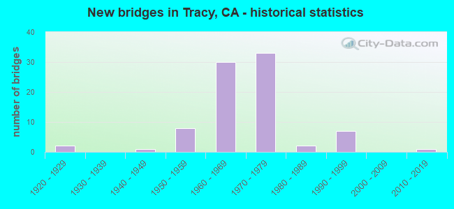
- New bridges - historical statistics
- 21920-1929
- 11940-1949
- 81950-1959
- 301960-1969
- 331970-1979
- 21980-1989
- 71990-1999
- 12010-2019
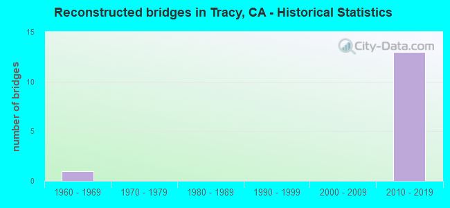
- Reconstructed bridges - Historical Statistics
- 11960-1969
- 01970-1979
- 01980-1989
- 01990-1999
- 02000-2009
- 132010-2019
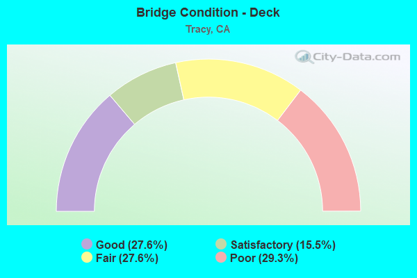
- Bridge Condition - Deck
- 27.6%Good
- 15.5%Satisfactory
- 27.6%Fair
- 29.3%Poor
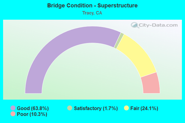
- Bridge Condition - Superstructure
- 63.8%Good
- 1.7%Satisfactory
- 24.1%Fair
- 10.3%Poor
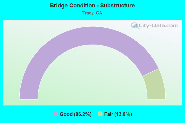
- Bridge Condition - Substructure
- 86.2%Good
- 13.8%Fair
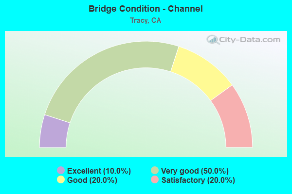
- Bridge Condition - Channel
- 10.0%Excellent
- 50.0%Very good
- 20.0%Good
- 20.0%Satisfactory
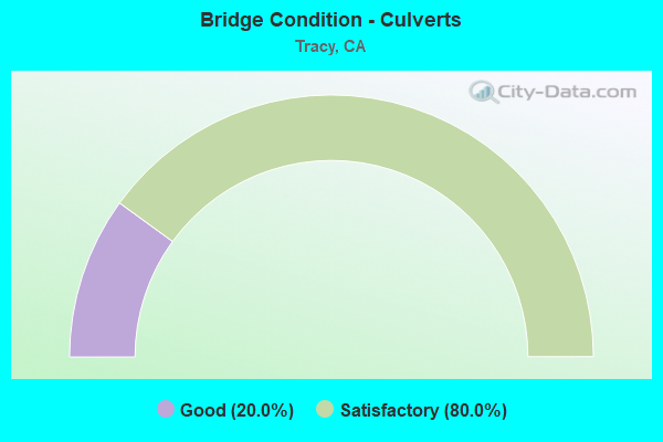
- Bridge Condition - Culverts
- 20.0%Good
- 80.0%Satisfactory
Find on map >> Show street view
Structure Number: 29C0083L, Location: 0.1 MI S. SCHULTE RD (Lat: 37.720744, Lng: -121.533700), Route carried "on" structure: County highway , Year Built: 1993, Status: Open, Structure Length: 6.95m (22.80ft), Average Daily Traffic: 4,403 (year 2009), Truck Traffic: 50%, Average Future Daily Traffic: 12,531 (year 2040), Design Load: HS 20+Mod, Features Intersected: CALIFORNIA AQUEDUCT, Facility Carried by Structure: MOUNTAIN HOUSE RD
Minimum Vertical Clearance: 30+ m (98+ ft), Kilometerpoint: 0.000, Lanes on structure: 2, Owner: County Highway Agency, Approaching Roadway Width: 9.1m (29.9ft), Skew: 1 degrees, Material/Design: Prestressed concrete continuous, Design/Construction: Stringer/Multi-beam, Number Of Spans In Main Unit: 3, Length of Maximum Span: 48.8m (160.1ft), Curb-To-Curb Width: 9.1m (29.9ft), Out-to-Out Width: 10.2m (33.5ft)
Condition: Deck: Fair, Superstructure: Good, Substructure: Good, Channel: Very good, Operating Rating: 54.1 metric tons, Method Used To Determine Operating Rating: Assigned rating based on Load Factor Design (LFD) reported in metric tons, Inventory Rating: 32.4 metric tons, Method Used To Determine Inventory Rating: Assigned rating based on Load Factor Design (LFD) reported in metric tons, Structural Evaluation: Better than present minimum criteria, Deck Geometry: Meets minimum limits, Waterway Adequacy: Equal to present desirable criteria, Approach Roadway Alignment: Equal to present minimum criteria, Designated Inspection Frequency: Every 24 months, Inspection Date: June 2020, Deck Structure Type: Concrete Cast-file-Place
Find on map >> Show street view
Structure Number: 29C0083R, Location: 0.1 MI S SCHULTE RD (Lat: 37.720722, Lng: -121.533503), Route carried "on" structure: County highway , Year Built: 1967, Status: Open, Structure Length: 4.72m (15.49ft), Average Daily Traffic: 4,403 (year 2009), Truck Traffic: 50%, Average Future Daily Traffic: 6,121 (year 2040), Design Load: HS 20, Features Intersected: CALIFORNIA AQUEDUCT, Facility Carried by Structure: MOUNTAIN HOUSE RD
Minimum Vertical Clearance: 30+ m (98+ ft), Kilometerpoint: 0.000, Lanes on structure: 2, Owner: County Highway Agency, Approaching Roadway Width: 9.8m (32.2ft), Skew: 1 degrees, Material/Design: Concrete continuous, Design/Construction: Tee Beam, Number Of Spans In Main Unit: 2, Length of Maximum Span: 23.8m (78.1ft), Curb-To-Curb Width: 9.8m (32.2ft), Out-to-Out Width: 10.4m (34.1ft)
Condition: Deck: Fair, Superstructure: Good, Substructure: Fair, Channel: Very good, Operating Rating: 33.4 metric tons, Method Used To Determine Operating Rating: Load and Resistance Factor Rating (LRFR) rating reported by rating factor(RF) method using HL-93 loadings, Inventory Rating: 25.9 metric tons, Method Used To Determine Inventory Rating: Load and Resistance Factor Rating (LRFR) rating reported by rating factor(RF) method using HL-93 loadings, Structural Evaluation: Somewhat better than minimum adequacy, Deck Geometry: Meets minimum limits, Waterway Adequacy: Equal to present desirable criteria, Approach Roadway Alignment: Equal to present minimum criteria, Designated Inspection Frequency: Every 24 months, Underwater Inspection Frequency: Every 72 months, Inspection Date: June 2020, Underwater Inspection Date: Febuary 2018, Deck Structure Type: Concrete Cast-file-Place
Find on map >> Show street view
Structure Number: 29C0179, Location: 3.3 MI SW OF I-580 (Lat: 37.639797, Lng: -121.491411), Route carried "on" structure: County highway , Year Built: 1959, Status: Open, Structure Length: 1.52m (4.99ft), Average Daily Traffic: 1,006 (year 2013), Truck Traffic: 10%, Average Future Daily Traffic: 3,989 (year 2040), Features Intersected: CORRAL HOLLOW CREEK, Facility Carried by Structure: CORRAL HOLLOW RD
Minimum Vertical Clearance: 30+ m (98+ ft), Kilometerpoint: 0.000, Lanes on structure: 2, Owner: County Highway Agency, Approaching Roadway Width: 9.5m (31.2ft), Skew: 3 degrees, Material/Design: Concrete continuous, Design/Construction: Culvert, Number Of Spans In Main Unit: 4, Length of Maximum Span: 3.7m (12.1ft), Curb-To-Curb Width: 9.5m (31.2ft), Out-to-Out Width: 9.8m (32.2ft)
Condition: Channel: Satisfactory, Culverts: Satisfactory, Operating Rating: 54.1 metric tons, Method Used To Determine Operating Rating: Field evaluation and documented engineering judgment, Inventory Rating: 32.4 metric tons, Method Used To Determine Inventory Rating: Field evaluation and documented engineering judgment, Structural Evaluation: Equal to present minimum criteria, Deck Geometry: Somewhat better than minimum adequacy, Waterway Adequacy: Equal to present minimum criteria, Approach Roadway Alignment: Equal to present minimum criteria, Designated Inspection Frequency: Every 48 months, Inspection Date: June 2020
Find on map >> Show street view
Structure Number: 29C0181, Location: 2.6 MI SW OF I-580 (Lat: 37.651000, Lng: -121.488992), Route carried "on" structure: County highway , Year Built: 1959, Status: Open, Structure Length: 1.52m (4.99ft), Average Daily Traffic: 1,006 (year 2013), Truck Traffic: 10%, Average Future Daily Traffic: 3,989 (year 2040), Features Intersected: CORRAL HOLLOW CREEK, Facility Carried by Structure: CORRAL HOLLOW RD
Minimum Vertical Clearance: 30+ m (98+ ft), Kilometerpoint: 0.000, Lanes on structure: 2, Owner: County Highway Agency, Approaching Roadway Width: 9.3m (30.5ft), Skew: 3 degrees, Material/Design: Concrete continuous, Design/Construction: Culvert, Number Of Spans In Main Unit: 4, Length of Maximum Span: 3.7m (12.1ft), Curb-To-Curb Width: 9.3m (30.5ft), Out-to-Out Width: 9.8m (32.2ft)
Condition: Channel: Satisfactory, Culverts: Good, Operating Rating: 54.1 metric tons, Method Used To Determine Operating Rating: Field evaluation and documented engineering judgment, Inventory Rating: 32.4 metric tons, Method Used To Determine Inventory Rating: Field evaluation and documented engineering judgment, Structural Evaluation: Better than present minimum criteria, Deck Geometry: Somewhat better than minimum adequacy, Waterway Adequacy: Meets minimum limits, Approach Roadway Alignment: Somewhat better than minimum adequacy, Designated Inspection Frequency: Every 48 months, Inspection Date: June 2020
Find on map >> Show street view
Structure Number: 29C0182, Location: 2.1 MI SW OF S.H. 580 (Lat: 37.656450, Lng: -121.486714), Route carried "on" structure: County highway , Year Built: 1959, Status: Open, Structure Length: 1.56m (5.12ft), Average Daily Traffic: 1,006 (year 2013), Truck Traffic: 5%, Average Future Daily Traffic: 4,020 (year 2040), Features Intersected: CORRAL HOLLOW CREEK, Facility Carried by Structure: CORRAL HOLLOW RD
Minimum Vertical Clearance: 30+ m (98+ ft), Kilometerpoint: 0.000, Lanes on structure: 2, Base Highway Network: Yes, Owner: County Highway Agency, Approaching Roadway Width: 9.3m (30.5ft), Material/Design: Concrete continuous, Design/Construction: Culvert, Number Of Spans In Main Unit: 4, Length of Maximum Span: 3.9m (12.8ft), Curb-To-Curb Width: 9.6m (31.5ft), Out-to-Out Width: 9.8m (32.2ft)
Condition: Channel: Good, Culverts: Satisfactory, Operating Rating: 54.1 metric tons, Method Used To Determine Operating Rating: Field evaluation and documented engineering judgment, Inventory Rating: 32.4 metric tons, Method Used To Determine Inventory Rating: Field evaluation and documented engineering judgment, Structural Evaluation: Equal to present minimum criteria, Deck Geometry: Somewhat better than minimum adequacy, Waterway Adequacy: Better than present minimum criteria, Approach Roadway Alignment: Somewhat better than minimum adequacy, Designated Inspection Frequency: Every 48 months, Inspection Date: June 2020
Find on map >> Show street view
Structure Number: 29C0183, Location: 1.5 MI SW OF I-580 (Lat: 37.658042, Lng: -121.476408), Route carried "on" structure: County highway , Year Built: 1959, Status: Open, Structure Length: 1.58m (5.18ft), Average Daily Traffic: 1,006 (year 2013), Truck Traffic: 5%, Average Future Daily Traffic: 4,020 (year 2040), Features Intersected: CORRAL HOLLOW CREEK, Facility Carried by Structure: CORRAL HOLLOW RD
Minimum Vertical Clearance: 30+ m (98+ ft), Kilometerpoint: 0.000, Lanes on structure: 2, Owner: County Highway Agency, Approaching Roadway Width: 9.3m (30.5ft), Skew: 3 degrees, Material/Design: Concrete continuous, Design/Construction: Culvert, Number Of Spans In Main Unit: 4, Length of Maximum Span: 3.7m (12.1ft), Curb-To-Curb Width: 9.6m (31.5ft), Out-to-Out Width: 9.8m (32.2ft)
Condition: Channel: Good, Culverts: Satisfactory, Operating Rating: 54.1 metric tons, Method Used To Determine Operating Rating: Field evaluation and documented engineering judgment, Inventory Rating: 32.4 metric tons, Method Used To Determine Inventory Rating: Field evaluation and documented engineering judgment, Structural Evaluation: Equal to present minimum criteria, Deck Geometry: Somewhat better than minimum adequacy, Waterway Adequacy: Equal to present desirable criteria, Approach Roadway Alignment: Better than present minimum criteria, Designated Inspection Frequency: Every 48 months, Inspection Date: June 2020, Deck Structure Type: Concrete Cast-file-Place, Wearing Surface/Protective System: Wearing Surface: Bituminous
Find on map >> Show street view
Structure Number: 29C0184, Location: 0.9 MI SW OF I-580 (Lat: 37.662819, Lng: -121.468553), Route carried "on" structure: County highway , Year Built: 1959, Status: Open, Structure Length: 1.58m (5.18ft), Average Daily Traffic: 1,006 (year 2013), Truck Traffic: 5%, Average Future Daily Traffic: 4,020 (year 2040), Features Intersected: CORRAL HOLLOW CREEK, Facility Carried by Structure: CORRAL HOLLOW RD
Minimum Vertical Clearance: 30+ m (98+ ft), Kilometerpoint: 0.000, Lanes on structure: 2, Owner: County Highway Agency, Approaching Roadway Width: 9.3m (30.5ft), Material/Design: Concrete continuous, Design/Construction: Culvert, Number Of Spans In Main Unit: 4, Length of Maximum Span: 3.9m (12.8ft), Curb-To-Curb Width: 9.6m (31.5ft), Out-to-Out Width: 9.8m (32.2ft)
Condition: Channel: Satisfactory, Culverts: Satisfactory, Operating Rating: 54.1 metric tons, Method Used To Determine Operating Rating: Field evaluation and documented engineering judgment, Inventory Rating: 32.4 metric tons, Method Used To Determine Inventory Rating: Field evaluation and documented engineering judgment, Structural Evaluation: Equal to present minimum criteria, Deck Geometry: Somewhat better than minimum adequacy, Waterway Adequacy: Better than present minimum criteria, Approach Roadway Alignment: Equal to present minimum criteria, Designated Inspection Frequency: Every 48 months, Inspection Date: June 2020
Find on map >> Show street view
Structure Number: 29C0185, Location: 0.9 MI N OF S.H. 580 (Lat: 37.679875, Lng: -121.452706), Route carried "on" structure: County highway , Year Built: 1967, Status: Open, Structure Length: 5.21m (17.09ft), Average Daily Traffic: 550 (year 1982), Truck Traffic: 20%, Average Future Daily Traffic: 1,087 (year 2040), Design Load: HS 20, Features Intersected: CALIFORNIA AQUEDUCT, Facility Carried by Structure: CORRAL HOLLOW RD
Minimum Vertical Clearance: 30+ m (98+ ft), Kilometerpoint: 0.000, Lanes on structure: 2, Owner: State Agenciy, Maintenance Responsibility: City or Municipal Highway Agency, Approaching Roadway Width: 9.4m (30.8ft), Skew: 3 degrees, Material/Design: Concrete continuous, Design/Construction: Tee Beam, Number Of Spans In Main Unit: 2, Length of Maximum Span: 26.2m (86.0ft), Curb or Sidewalk Widths: Left: 0.2m (0.7ft), Right: 0.2m (0.7ft), Curb-To-Curb Width: 9.8m (32.2ft), Out-to-Out Width: 10.2m (33.5ft)
Condition: Deck: Poor, Superstructure: Fair, Substructure: Fair, Channel: Very good, Operating Rating: 43.4 metric tons, Method Used To Determine Operating Rating: Load and Resistance Factor Rating (LRFR) rating reported by rating factor(RF) method using HL-93 loadings, Inventory Rating: 32.1 metric tons, Method Used To Determine Inventory Rating: Load and Resistance Factor Rating (LRFR) rating reported by rating factor(RF) method using HL-93 loadings, Structural Evaluation: Somewhat better than minimum adequacy, Deck Geometry: Equal to present minimum criteria, Waterway Adequacy: Superior to present desirable criteria, Approach Roadway Alignment: Equal to present desirable criteria, Designated Inspection Frequency: Every 24 months, Underwater Inspection Frequency: Every 72 months, Inspection Date: June 2020, Underwater Inspection Date: Febuary 2018, Deck Structure Type: Concrete Cast-file-Place, Wearing Surface/Protective System: Wearing Surface: Bituminous
Find on map >> Show street view
Structure Number: 29C0186, Location: 1.5 MI N OF I-580 (Lat: 37.691600, Lng: -121.452772), Route carried "on" structure: County highway , Year Built: 1947, Status: Open, Structure Length: 3.26m (10.70ft), Average Daily Traffic: 1,006 (year 2013), Truck Traffic: 20%, Average Future Daily Traffic: 1,087 (year 2040), Design Load: H 20, Features Intersected: DELTA-MENDOTA CANAL, Facility Carried by Structure: CORRAL HOLLOW ROAD
Minimum Vertical Clearance: 30+ m (98+ ft), Kilometerpoint: 0.000, Lanes on structure: 2, Owner: County Highway Agency, Approaching Roadway Width: 7.3m (24.0ft), Material/Design: Concrete continuous, Design/Construction: Tee Beam, Number Of Spans In Main Unit: 3, Length of Maximum Span: 12.2m (40.0ft), Curb or Sidewalk Widths: Left: 0.6m (2.0ft), Right: 0.6m (2.0ft), Curb-To-Curb Width: 7.3m (24.0ft), Out-to-Out Width: 8.7m (28.5ft)
Condition: Deck: Fair, Superstructure: Good, Substructure: Fair, Channel: Very good, Operating Rating: 25.3 metric tons, Method Used To Determine Operating Rating: Load and Resistance Factor Rating (LRFR) rating reported by rating factor(RF) method using HL-93 loadings, Inventory Rating: 19.4 metric tons, Method Used To Determine Inventory Rating: Load and Resistance Factor Rating (LRFR) rating reported by rating factor(RF) method using HL-93 loadings, Structural Evaluation: Somewhat better than minimum adequacy, Deck Geometry: Meets minimum limits, Waterway Adequacy: Equal to present desirable criteria, Approach Roadway Alignment: Equal to present desirable criteria, Designated Inspection Frequency: Every 24 months, Underwater Inspection Frequency: Every 72 months, Inspection Date: June 2020, Underwater Inspection Date: May 2020, Deck Structure Type: Concrete Cast-file-Place
Find on map >> Show street view
Structure Number: 29C022, Location: 0.5 MI N OF S.H. 132 (Lat: 37.643475, Lng: -121.397600), Route carried "on" structure: County highway , Year Built: 1965, Status: Open, Structure Length: 4.63m (15.19ft), Average Daily Traffic: 1,000 (year 1982), Truck Traffic: 10%, Average Future Daily Traffic: 2,173 (year 2040), Features Intersected: CALIFORNIA AQUEDUCT, Facility Carried by Structure: CHRISMAN RD
Minimum Vertical Clearance: 30+ m (98+ ft), Kilometerpoint: 0.000, Lanes on structure: 2, Owner: State Agenciy, Maintenance Responsibility: County Highway Agency, Approaching Roadway Width: 9.8m (32.2ft), Material/Design: Concrete continuous, Design/Construction: Tee Beam, Number Of Spans In Main Unit: 2, Length of Maximum Span: 22.6m (74.1ft), Curb or Sidewalk Widths: Left: 0.3m (1.0ft), Right: 0.3m (1.0ft), Curb-To-Curb Width: 9.8m (32.2ft), Out-to-Out Width: 10.4m (34.1ft)
Condition: Deck: Fair, Superstructure: Good, Substructure: Fair, Channel: Very good, Operating Rating: 39.9 metric tons, Method Used To Determine Operating Rating: Load and Resistance Factor Rating (LRFR) rating reported by rating factor(RF) method using HL-93 loadings, Inventory Rating: 28.5 metric tons, Method Used To Determine Inventory Rating: Load and Resistance Factor Rating (LRFR) rating reported by rating factor(RF) method using HL-93 loadings, Structural Evaluation: Somewhat better than minimum adequacy, Deck Geometry: Equal to present minimum criteria, Waterway Adequacy: Superior to present desirable criteria, Approach Roadway Alignment: Equal to present desirable criteria, Designated Inspection Frequency: Every 24 months, Underwater Inspection Frequency: Every 72 months, Inspection Date: June 2020, Underwater Inspection Date: Febuary 2018, Deck Structure Type: Concrete Cast-file-Place, Wearing Surface/Protective System: Wearing Surface: Bituminous
Find on map >> Show street view
Structure Number: 29C0221, Location: 0.9 MI N DURHAM FERRY RD (Lat: 37.680547, Lng: -121.397842), Route carried "on" structure: County highway , Year Built: 1960, Status: Open, Structure Length: 1.28m (4.20ft), Average Daily Traffic: 3,000 (year 2009), Truck Traffic: 5%, Average Future Daily Traffic: 3,144 (year 2040), Features Intersected: CORRAL HOLLOW CREEK, Facility Carried by Structure: CHRISMAN RD
Minimum Vertical Clearance: 30+ m (98+ ft), Kilometerpoint: 0.000, Lanes on structure: 2, Owner: County Highway Agency, Approaching Roadway Width: 9.1m (29.9ft), Material/Design: Concrete continuous, Design/Construction: Slab, Number Of Spans In Main Unit: 2, Length of Maximum Span: 6.1m (20.0ft), Curb-To-Curb Width: 12.2m (40.0ft), Out-to-Out Width: 12.4m (40.7ft)
Condition: Deck: Good, Superstructure: Good, Substructure: Good, Channel: Good, Operating Rating: 50.9 metric tons, Method Used To Determine Operating Rating: Load Factor (LF), Inventory Rating: 30.5 metric tons, Method Used To Determine Inventory Rating: Load Factor (LF), Structural Evaluation: Better than present minimum criteria, Deck Geometry: Equal to present minimum criteria, Waterway Adequacy: Superior to present desirable criteria, Approach Roadway Alignment: Equal to present desirable criteria, Designated Inspection Frequency: Every 24 months, Inspection Date: June 2020, Deck Structure Type: Concrete Cast-file-Place, Wearing Surface/Protective System: Wearing Surface: Bituminous
Find on map >> Show street view
Structure Number: 29C0312, Location: 0.1 MI S OF CANAL BLVD (Lat: 37.773975, Lng: -121.382536), Route carried "on" structure: County highway , Year Built: 1980, Status: Open, Structure Length: 4.65m (15.26ft), Average Daily Traffic: 912 (year 2013), Truck Traffic: 10%, Average Future Daily Traffic: 640 (year 2037), Design Load: HS 20+Mod, Features Intersected: TOM PAINE SLOUGH, Facility Carried by Structure: PARADISE ROAD
Minimum Vertical Clearance: 30+ m (98+ ft), Kilometerpoint: 0.000, Lanes on structure: 2, Owner: County Highway Agency, Approaching Roadway Width: 6.1m (20.0ft), Skew: 9 degrees, Material/Design: Concrete continuous, Design/Construction: Slab, Number Of Spans In Main Unit: 5, Length of Maximum Span: 9.1m (29.9ft), Curb-To-Curb Width: 8.7m (28.5ft), Out-to-Out Width: 9.0m (29.5ft)
Condition: Deck: Fair, Superstructure: Fair, Substructure: Good, Channel: Satisfactory, Operating Rating: 80.4 metric tons, Method Used To Determine Operating Rating: Load Factor (LF), Inventory Rating: 48.3 metric tons, Method Used To Determine Inventory Rating: Load Factor (LF), Structural Evaluation: Somewhat better than minimum adequacy, Deck Geometry: Somewhat better than minimum adequacy, Waterway Adequacy: Equal to present desirable criteria, Approach Roadway Alignment: Somewhat better than minimum adequacy, Designated Inspection Frequency: Every 24 months, Underwater Inspection Frequency: Every 60 months, Inspection Date: September 2020, Underwater Inspection Date: August 2020, Deck Structure Type: Concrete Cast-file-Place
Find on map >> Show street view
Structure Number: 29C0313, Location: 0.1 MI S OF CANAL BLVD (Lat: 37.784031, Lng: -121.414578), Route carried "on" structure: County highway , Year Built: 1987, Status: Open, Structure Length: 4.47m (14.67ft), Average Daily Traffic: 1,036 (year 2004), Truck Traffic: 10%, Average Future Daily Traffic: 766 (year 2042), Design Load: HS 20+Mod, Features Intersected: TOM PAINE SLOUGH, Facility Carried by Structure: MACARTHUR DRIVE
Minimum Vertical Clearance: 30+ m (98+ ft), Kilometerpoint: 0.000, Lanes on structure: 2, Owner: County Highway Agency, Approaching Roadway Width: 7.3m (24.0ft), Skew: 2 degrees, Material/Design: Concrete continuous, Design/Construction: Slab, Number Of Spans In Main Unit: 4, Length of Maximum Span: 11.0m (36.1ft), Curb-To-Curb Width: 9.3m (30.5ft), Out-to-Out Width: 9.7m (31.8ft)
Condition: Deck: Good, Superstructure: Good, Substructure: Good, Channel: Very good, Operating Rating: 54.1 metric tons, Method Used To Determine Operating Rating: Assigned rating based on Load Factor Design (LFD) reported in metric tons, Inventory Rating: 32.4 metric tons, Method Used To Determine Inventory Rating: Assigned rating based on Load Factor Design (LFD) reported in metric tons, Structural Evaluation: Better than present minimum criteria, Deck Geometry: Somewhat better than minimum adequacy, Waterway Adequacy: Equal to present desirable criteria, Approach Roadway Alignment: Equal to present minimum criteria, Designated Inspection Frequency: Every 48 months, Underwater Inspection Frequency: Every 60 months, Inspection Date: September 2020, Underwater Inspection Date: August 2020, Deck Structure Type: Concrete Cast-file-Place
Find on map >> Show street view
Structure Number: 29C032, Location: 1.3 MI N OF SR 580 (Lat: 37.677494, Lng: -121.434364), Route carried "on" structure: County highway , Year Built: 1990, Status: Open, Structure Length: 1.83m (6.00ft), Average Daily Traffic: 999 (year 2013), Truck Traffic: 20%, Average Future Daily Traffic: 2,173 (year 2040), Design Load: HS 20+Mod, Features Intersected: CORRAL HOLLOW CREEK, Facility Carried by Structure: TRACY BOULEVARD
Minimum Vertical Clearance: 30+ m (98+ ft), Kilometerpoint: 0.000, Lanes on structure: 2, Owner: County Highway Agency, Approaching Roadway Width: 6.1m (20.0ft), Material/Design: Concrete continuous, Design/Construction: Slab, Number Of Spans In Main Unit: 2, Length of Maximum Span: 9.1m (29.9ft), Curb-To-Curb Width: 9.1m (29.9ft), Out-to-Out Width: 9.3m (30.5ft)
Condition: Deck: Fair, Superstructure: Fair, Substructure: Good, Channel: Very good, Operating Rating: 54.1 metric tons, Method Used To Determine Operating Rating: Assigned rating based on Load Factor Design (LFD) reported in metric tons, Inventory Rating: 32.4 metric tons, Method Used To Determine Inventory Rating: Assigned rating based on Load Factor Design (LFD) reported in metric tons, Structural Evaluation: Somewhat better than minimum adequacy, Deck Geometry: Equal to present minimum criteria, Waterway Adequacy: Superior to present desirable criteria, Approach Roadway Alignment: Equal to present desirable criteria, Designated Inspection Frequency: Every 24 months, Inspection Date: June 2020, Deck Structure Type: Concrete Cast-file-Place
Find on map >> Show street view
Structure Number: 29C033, Location: 0.6 MI N OF LONE TREE RD (Lat: 37.835431, Lng: -121.108178), Route carried "on" structure: County highway , Year Built: 1926, Status: Open, Structure Length: 1.13m (3.71ft), Average Daily Traffic: 380 (year 2013), Truck Traffic: 5%, Average Future Daily Traffic: 544 (year 2040), Design Load: H 15, Features Intersected: LONE TREE CREEK, Facility Carried by Structure: MURPHY ROAD
Minimum Vertical Clearance: 30+ m (98+ ft), Kilometerpoint: 0.000, Lanes on structure: 2, Owner: County Highway Agency, Approaching Roadway Width: 5.1m (16.7ft), Skew: 3 degrees, Material/Design: Concrete continuous, Design/Construction: Slab, Number Of Spans In Main Unit: 2, Length of Maximum Span: 5.3m (17.4ft), Curb-To-Curb Width: 6.1m (20.0ft), Out-to-Out Width: 6.7m (22.0ft)
Condition: Deck: Good, Superstructure: Good, Substructure: Good, Channel: Good, Operating Rating: 46.7 metric tons, Method Used To Determine Operating Rating: Load Factor (LF), Inventory Rating: 28.2 metric tons, Method Used To Determine Inventory Rating: Load Factor (LF), Structural Evaluation: Better than present minimum criteria, Deck Geometry: Meets minimum limits, Waterway Adequacy: Equal to present desirable criteria, Approach Roadway Alignment: Equal to present desirable criteria, Designated Inspection Frequency: Every 24 months, Inspection Date: September 2020, Deck Structure Type: Concrete Cast-file-Place, Wearing Surface/Protective System: Wearing Surface: Bituminous
Find on map >> Show street view
Structure Number: 29C0335, Location: 0.8 MI S OF I-205 (Lat: 37.729981, Lng: -121.531264), Route carried "on" structure: County highway , Year Built: 1993, Status: Open, Structure Length: 5.21m (17.09ft), Average Daily Traffic: 7,819 (year 2007), Truck Traffic: 15%, Average Future Daily Traffic: 9,182 (year 2040), Design Load: HS 20+Mod, Features Intersected: DELTA-MENDOTA CANAL, Facility Carried by Structure: MOUNTAIN HOUSE RD
Minimum Vertical Clearance: 30+ m (98+ ft), Kilometerpoint: 0.000, Lanes on structure: 2, Base Highway Network: Yes, Owner: City or Municipal Highway Agency, Approaching Roadway Width: 9.1m (29.9ft), Skew: 2 degrees, Material/Design: Prestressed concrete continuous, Design/Construction: Stringer/Multi-beam, Number Of Spans In Main Unit: 2, Length of Maximum Span: 41.8m (137.1ft), Curb-To-Curb Width: 9.1m (29.9ft), Out-to-Out Width: 10.2m (33.5ft)
Condition: Deck: Fair, Superstructure: Good, Substructure: Good, Channel: Very good, Operating Rating: 54.1 metric tons, Method Used To Determine Operating Rating: Assigned rating based on Load Factor Design (LFD) reported in metric tons, Inventory Rating: 32.4 metric tons, Method Used To Determine Inventory Rating: Assigned rating based on Load Factor Design (LFD) reported in metric tons, Structural Evaluation: Better than present minimum criteria, Deck Geometry: High priority of corrective action, Waterway Adequacy: Equal to present desirable criteria, Approach Roadway Alignment: Better than present minimum criteria, Designated Inspection Frequency: Every 24 months, Inspection Date: June 2020, Deck Structure Type: Concrete Cast-file-Place
Find on map >> Show street view
Structure Number: 29C034, Location: 1.0 MI N FRENCH CAMP/RD (Lat: 37.899072, Lng: -121.270669), Route carried "on" structure: County highway , Year Built: 1923, Year Reconstructed: 1972, Status: Open, Structure Length: 2.10m (6.89ft), Average Daily Traffic: 4,300 (year 2017), Truck Traffic: 22%, Average Future Daily Traffic: 3,207 (year 2039), Features Intersected: N BR FRENCH CAMP SLOUGH, Facility Carried by Structure: MCKINLEY ROAD
Minimum Vertical Clearance: 30+ m (98+ ft), Kilometerpoint: 0.000, Lanes on structure: 2, Owner: City or Municipal Highway Agency, Approaching Roadway Width: 7.3m (24.0ft), Material/Design: Concrete continuous, Design/Construction: Slab, Number Of Spans In Main Unit: 4, Length of Maximum Span: 5.2m (17.1ft), Curb-To-Curb Width: 10.1m (33.1ft), Out-to-Out Width: 10.7m (35.1ft)
Condition: Deck: Good, Superstructure: Good, Substructure: Good, Channel: Good, Operating Rating: 42.1 metric tons, Method Used To Determine Operating Rating: Load Factor (LF), Inventory Rating: 25.3 metric tons, Method Used To Determine Inventory Rating: Load Factor (LF), Structural Evaluation: Equal to present minimum criteria, Deck Geometry: Meets minimum limits, Waterway Adequacy: Equal to present desirable criteria, Approach Roadway Alignment: Equal to present desirable criteria, Designated Inspection Frequency: Every 24 months, Inspection Date: Febuary 2021, Deck Structure Type: Concrete Cast-file-Place, Wearing Surface/Protective System: Wearing Surface: Integral Concrete
Find on map >> Show street view
Structure Number: 29C0346, Location: 0.2 MI W HANSEN RD (Lat: 37.721856, Lng: -121.517397), Route carried "on" structure: County highway , Year Built: 1993, Status: Open, Structure Length: 4.84m (15.88ft), Average Daily Traffic: 6,662 (year 2013), Truck Traffic: 15%, Average Future Daily Traffic: 8,161 (year 2040), Design Load: HS 20+Mod, Features Intersected: DELTA-MENDOTA CANAL, Facility Carried by Structure: SCHULTE ROAD
Minimum Vertical Clearance: 30+ m (98+ ft), Kilometerpoint: 0.000, Lanes on structure: 2, Owner: City or Municipal Highway Agency, Approaching Roadway Width: 14.0m (45.9ft), Skew: 1 degrees, Material/Design: Prestressed concrete continuous, Design/Construction: Stringer/Multi-beam, Number Of Spans In Main Unit: 2, Length of Maximum Span: 39.9m (130.9ft), Curb-To-Curb Width: 14.0m (45.9ft), Out-to-Out Width: 15.1m (49.5ft)
Condition: Deck: Fair, Superstructure: Good, Substructure: Good, Channel: Excellent, Operating Rating: 54.1 metric tons, Method Used To Determine Operating Rating: Assigned rating based on Load Factor Design (LFD) reported in metric tons, Inventory Rating: 32.4 metric tons, Method Used To Determine Inventory Rating: Assigned rating based on Load Factor Design (LFD) reported in metric tons, Structural Evaluation: Better than present minimum criteria, Deck Geometry: Superior to present desirable criteria, Waterway Adequacy: Equal to present desirable criteria, Approach Roadway Alignment: Equal to present minimum criteria, Designated Inspection Frequency: Every 24 months, Inspection Date: June 2020, Deck Structure Type: Concrete Cast-file-Place
Find on map >> Show street view
Structure Number: 29C0347, Location: 0.3 MI S SCHULTE RD (Lat: 37.718047, Lng: -121.513033), Route carried "on" structure: County highway , Year Built: 1993, Status: Open, Structure Length: 4.83m (15.85ft), Average Daily Traffic: 2,119 (year 2013), Truck Traffic: 15%, Average Future Daily Traffic: 4,081 (year 2040), Design Load: HS 20+Mod, Features Intersected: DELTA-MENDOTA CANAL, Facility Carried by Structure: HANSEN ROAD
Minimum Vertical Clearance: 30+ m (98+ ft), Kilometerpoint: 0.000, Lanes on structure: 2, Owner: County Highway Agency, Approaching Roadway Width: 14.6m (47.9ft), Skew: 1 degrees, Material/Design: Prestressed concrete continuous, Design/Construction: Stringer/Multi-beam, Number Of Spans In Main Unit: 2, Length of Maximum Span: 39.3m (128.9ft), Curb or Sidewalk Widths: Left: 0.0m, Right: 1.6m (5.2ft), Curb-To-Curb Width: 13.4m (44.0ft), Out-to-Out Width: 15.8m (51.8ft)
Condition: Deck: Fair, Superstructure: Good, Substructure: Good, Channel: Very good, Operating Rating: 54.1 metric tons, Method Used To Determine Operating Rating: Assigned rating based on Load Factor Design (LFD) reported in metric tons, Inventory Rating: 32.4 metric tons, Method Used To Determine Inventory Rating: Assigned rating based on Load Factor Design (LFD) reported in metric tons, Structural Evaluation: Better than present minimum criteria, Deck Geometry: Better than present minimum criteria, Waterway Adequacy: Equal to present desirable criteria, Approach Roadway Alignment: Equal to present desirable criteria, Designated Inspection Frequency: Every 24 months, Inspection Date: June 2020, Deck Structure Type: Concrete Cast-file-Place
Find on map >> Show street view
Structure Number: 29C0348, Location: 0.8 MI S VALPICO ROAD (Lat: 37.699147, Lng: -121.476467), Route carried "on" structure: County highway , Year Built: 1950, Status: Open, Structure Length: 3.30m (10.83ft), Average Daily Traffic: 1,439 (year 2013), Truck Traffic: 10%, Average Future Daily Traffic: 3,000 (year 2037), Design Load: HS 15, Features Intersected: DELTA-MENDOTA CANAL, Facility Carried by Structure: LAMMERS ROAD
Minimum Vertical Clearance: 30+ m (98+ ft), Kilometerpoint: 0.000, Lanes on structure: 2, Owner: County Highway Agency, Approaching Roadway Width: 5.2m (17.1ft), Skew: 1 degrees, Material/Design: Concrete continuous, Design/Construction: Tee Beam, Number Of Spans In Main Unit: 3, Length of Maximum Span: 12.2m (40.0ft), Curb or Sidewalk Widths: Left: 0.7m (2.3ft), Right: 0.7m (2.3ft), Curb-To-Curb Width: 6.1m (20.0ft), Out-to-Out Width: 7.5m (24.6ft)
Condition: Deck: Good, Superstructure: Good, Substructure: Fair, Channel: Very good, Operating Rating: 27.9 metric tons, Method Used To Determine Operating Rating: Load Factor (LF), Inventory Rating: 16.8 metric tons, Method Used To Determine Inventory Rating: Load Factor (LF), Structural Evaluation: Meets minimum limits, Deck Geometry: High priority of replacement, Waterway Adequacy: Equal to present desirable criteria, Approach Roadway Alignment: Better than present minimum criteria, Designated Inspection Frequency: Every 24 months, Underwater Inspection Frequency: Every 72 months, Inspection Date: June 2020, Underwater Inspection Date: May 2020, Deck Structure Type: Concrete Cast-file-Place, Wearing Surface/Protective System: Wearing Surface: Bituminous
Find on map >> Show street view
Structure Number: 29C0349, Location: 2.6 MI S LINNE ROAD (Lat: 37.658569, Lng: -121.416033), Route carried "on" structure: County highway , Year Built: 1950, Status: Open, Structure Length: 3.29m (10.79ft), Average Daily Traffic: 2,165 (year 2013), Truck Traffic: 1%, Average Future Daily Traffic: 3,061 (year 2040), Design Load: HS 15, Features Intersected: DELTA-MENDOTA CANAL, Facility Carried by Structure: MACARTHUR DRIVE
Minimum Vertical Clearance: 30+ m (98+ ft), Kilometerpoint: 0.000, Lanes on structure: 2, Owner: County Highway Agency, Approaching Roadway Width: 4.9m (16.1ft), Material/Design: Concrete continuous, Design/Construction: Tee Beam, Number Of Spans In Main Unit: 3, Length of Maximum Span: 12.2m (40.0ft), Curb or Sidewalk Widths: Left: 0.7m (2.3ft), Right: 0.7m (2.3ft), Curb-To-Curb Width: 6.2m (20.3ft), Out-to-Out Width: 7.5m (24.6ft)
Condition: Deck: Fair, Superstructure: Good, Substructure: Fair, Channel: Very good, Operating Rating: 31.8 metric tons, Method Used To Determine Operating Rating: Load Factor (LF), Inventory Rating: 19.1 metric tons, Method Used To Determine Inventory Rating: Load Factor (LF), Structural Evaluation: Somewhat better than minimum adequacy, Deck Geometry: High priority of replacement, Waterway Adequacy: Superior to present desirable criteria, Approach Roadway Alignment: Better than present minimum criteria, Designated Inspection Frequency: Every 24 months, Underwater Inspection Frequency: Every 72 months, Inspection Date: June 2020, Underwater Inspection Date: May 2020, Deck Structure Type: Concrete Cast-file-Place
Find on map >> Show street view
Structure Number: 29C0369, Location: 1.1 MI S LINNE RD (Lat: 37.680833, Lng: -121.416144), Route carried "on" structure: County highway , Year Built: 1967, Status: Open, Structure Length: 1.28m (4.20ft), Average Daily Traffic: 2,165 (year 2013), Truck Traffic: 30%, Average Future Daily Traffic: 1,087 (year 2040), Design Load: HS 20, Features Intersected: CORRAL HOLLOW CREEK, Facility Carried by Structure: MAC ARTHUR DR
Minimum Vertical Clearance: 30+ m (98+ ft), Kilometerpoint: 0.000, Lanes on structure: 2, Owner: County Highway Agency, Approaching Roadway Width: 7.0m (23.0ft), Material/Design: Concrete continuous, Design/Construction: Slab, Number Of Spans In Main Unit: 2, Length of Maximum Span: 6.1m (20.0ft), Curb-To-Curb Width: 12.2m (40.0ft), Out-to-Out Width: 12.4m (40.7ft)
Condition: Deck: Satisfactory, Superstructure: Satisfactory, Substructure: Good, Channel: Good, Operating Rating: 50.5 metric tons, Method Used To Determine Operating Rating: Load Factor (LF), Inventory Rating: 30.5 metric tons, Method Used To Determine Inventory Rating: Load Factor (LF), Structural Evaluation: Equal to present minimum criteria, Deck Geometry: Equal to present minimum criteria, Waterway Adequacy: Equal to present minimum criteria, Approach Roadway Alignment: Equal to present desirable criteria, Designated Inspection Frequency: Every 24 months, Inspection Date: June 2020, Deck Structure Type: Concrete Cast-file-Place
Find on map >> Show street view
Structure Number: 29C0383, Location: 2.5 MI S OF UNNE RD (Lat: 37.660706, Lng: -121.434306), Route carried "on" structure: County highway , Year Built: 1967, Status: Open, Structure Length: 6.37m (20.90ft), Average Daily Traffic: 1,589 (year 2002), Truck Traffic: 5%, Average Future Daily Traffic: 2,173 (year 2040), Design Load: HS 20, Features Intersected: CALIFORNIA AQUEDUCT, Facility Carried by Structure: TRACY BLVD
Minimum Vertical Clearance: 30+ m (98+ ft), Kilometerpoint: 0.000, Lanes on structure: 2, Owner: State Agenciy, Approaching Roadway Width: 7.3m (24.0ft), Skew: 4 degrees, Material/Design: Concrete continuous, Design/Construction: Tee Beam, Number Of Spans In Main Unit: 3, Length of Maximum Span: 24.4m (80.1ft), Curb or Sidewalk Widths: Left: 0.3m (1.0ft), Right: 0.3m (1.0ft), Curb-To-Curb Width: 9.8m (32.2ft), Out-to-Out Width: 10.4m (34.1ft)
Condition: Deck: Good, Superstructure: Good, Substructure: Fair, Channel: Very good, Operating Rating: 34.3 metric tons, Method Used To Determine Operating Rating: Load and Resistance Factor Rating (LRFR) rating reported by rating factor(RF) method using HL-93 loadings, Inventory Rating: 26.6 metric tons, Method Used To Determine Inventory Rating: Load and Resistance Factor Rating (LRFR) rating reported by rating factor(RF) method using HL-93 loadings, Structural Evaluation: Somewhat better than minimum adequacy, Deck Geometry: Somewhat better than minimum adequacy, Waterway Adequacy: Superior to present desirable criteria, Approach Roadway Alignment: Equal to present desirable criteria, Designated Inspection Frequency: Every 24 months, Underwater Inspection Frequency: Every 72 months, Inspection Date: June 2020, Underwater Inspection Date: Febuary 2018, Deck Structure Type: Concrete Cast-file-Place
Find on map >> Show street view
Structure Number: 29C0441, Location: N OF ROUTE 205 (Lat: 37.768572, Lng: -121.373856), Route carried "on" structure: Business County highway , Year Built: 2011, Status: Open, Structure Length: 3.23m (10.60ft), Average Daily Traffic: 258 (year 2013), Truck Traffic: 5%, Average Future Daily Traffic: 417 (year 2042), Design Load: HS 20+Mod, Features Intersected: TOM PAINE SLOUGH, Facility Carried by Structure: EL RANCHO ROAD
Minimum Vertical Clearance: 30+ m (98+ ft), Kilometerpoint: 0.000, Lanes on structure: 2, Owner: County Highway Agency, Approaching Roadway Width: 8.5m (27.9ft), Material/Design: Concrete continuous, Design/Construction: Slab, Number Of Spans In Main Unit: 3, Length of Maximum Span: 12.2m (40.0ft), Curb-To-Curb Width: 8.5m (27.9ft), Out-to-Out Width: 9.4m (30.8ft)
Condition: Deck: Good, Superstructure: Good, Substructure: Good, Channel: Satisfactory, Operating Rating: 54.1 metric tons, Method Used To Determine Operating Rating: Assigned rating based on Load Factor Design (LFD) reported in metric tons, Inventory Rating: 32.4 metric tons, Method Used To Determine Inventory Rating: Assigned rating based on Load Factor Design (LFD) reported in metric tons, Structural Evaluation: Better than present minimum criteria, Deck Geometry: Equal to present minimum criteria, Waterway Adequacy: Somewhat better than minimum adequacy, Approach Roadway Alignment: Better than present minimum criteria, Designated Inspection Frequency: Every 48 months, Underwater Inspection Frequency: Every 60 months, Inspection Date: September 2020, Underwater Inspection Date: August 2020, Deck Structure Type: Concrete Cast-file-Place
Find on map >> Show street view
Structure Number: 29C0475, Location: 0.8 MI S OF W SCHULTE RD (Lat: 37.709986, Lng: -121.512958), Route carried "on" structure: County highway , Year Built: 1965, Status: Open, Structure Length: 4.48m (14.70ft), Average Daily Traffic: 1,932 (year 2019), Truck Traffic: 90%, Average Future Daily Traffic: 3,000 (year 2038), Design Load: HS 20, Features Intersected: CALIFORNIA AQUEDUCT, Facility Carried by Structure: HANSEN ROAD
Minimum Vertical Clearance: 30+ m (98+ ft), Kilometerpoint: 0.000, Lanes on structure: 2, Owner: State Agenciy, Approaching Roadway Width: 14.5m (47.6ft), Material/Design: Concrete continuous, Design/Construction: Tee Beam, Number Of Spans In Main Unit: 2, Length of Maximum Span: 22.0m (72.2ft), Curb or Sidewalk Widths: Left: 0.3m (1.0ft), Right: 0.3m (1.0ft), Curb-To-Curb Width: 7.3m (24.0ft), Out-to-Out Width: 7.9m (25.9ft)
Condition: Deck: Fair, Superstructure: Good, Substructure: Good, Channel: Very good, Operating Rating: 29.5 metric tons, Method Used To Determine Operating Rating: Field evaluation and documented engineering judgment, Inventory Rating: 17.5 metric tons, Method Used To Determine Inventory Rating: Field evaluation and documented engineering judgment, Structural Evaluation: Meets minimum limits, Deck Geometry: Meets minimum limits, Waterway Adequacy: Equal to present desirable criteria, Approach Roadway Alignment: Equal to present desirable criteria, Length Of Structure Improvement: 4.48m (14.70ft), Designated Inspection Frequency: Every 24 months, Inspection Date: August 2021, Bridge Improvement Cost: $355,000, Roadway Improvement Cost: $71,000, Total Project Cost: $596,000 ( Estimate for 2021), Deck Structure Type: Concrete Cast-file-Place
Find on map >> Show street view
Structure Number: 29 0024, Location: 10-SJ-580-13.54 (Lat: 37.719464, Lng: -121.535717), Route carried "under" structure: Interstate 580, Year Built: 1967, Structure Length: 0. m, Average Daily Traffic: 26,600 (year 2009), Truck Traffic: 14%, Features Intersected: ROUTE 580, Facility Carried by Structure: PATTERSON PASS RD
Minimum Vertical Clearance: 5.08m (16.67ft), Kilometerpoint: 13.540, Lanes on structure: 2, Lanes under structure: 4, Material/Design: Concrete continuous, Design/Construction: Box Beam or Girders - Multiple, Length of Maximum Span: 24.7m (81.0ft)
Find on map >> Show street view
Structure Number: 29 0074L, Location: 10-SJ-205-R4.54 (Lat: 37.748764, Lng: -121.476353), Route carried "under" structure: County highway Y331, Year Built: 1970, Structure Length: 0. m, Average Daily Traffic: 4,310 (year 1998), Truck Traffic: 10%, Features Intersected: UP RR & BYRON RD, Facility Carried by Structure: INTERSTATE 205 WB
Minimum Vertical Clearance: 7.49m (24.57ft), Kilometerpoint: 0.000, Lanes on structure: 3, Lanes under structure: 2, Material/Design: Prestressed concrete continuous, Design/Construction: Tee Beam, Length of Maximum Span: 23.1m (75.8ft)
Find on map >> Show street view
Structure Number: 29 0074R, Location: 10-SJ-205-R4.54 (Lat: 37.748614, Lng: -121.476006), Route carried "under" structure: County highway Y331, Year Built: 1970, Structure Length: 0. m, Average Daily Traffic: 4,310 (year 1998), Truck Traffic: 10%, Features Intersected: UP RR & BYRON RD, Facility Carried by Structure: INTERSTATE 205 EB
Minimum Vertical Clearance: 7.34m (24.08ft), Kilometerpoint: 0.000, Lanes on structure: 3, Lanes under structure: 2, Material/Design: Prestressed concrete, Design/Construction: Tee Beam, Length of Maximum Span: 23.1m (75.8ft)
Find on map >> Show street view
Structure Number: 29 008, Location: 10-SJ-580-8.15 (Lat: 37.671947, Lng: -121.457519), Route carried "under" structure: Interstate 580, Year Built: 1966, Structure Length: 0. m, Average Daily Traffic: 26,600 (year 2009), Truck Traffic: 14%, Features Intersected: ROUTE 580, Facility Carried by Structure: CORRAL HOLLOW RD
Minimum Vertical Clearance: 5.25m (17.22ft), Kilometerpoint: 8.150, Lanes on structure: 2, Lanes under structure: 4, Material/Design: Concrete continuous, Design/Construction: Box Beam or Girders - Multiple, Length of Maximum Span: 24.7m (81.0ft)
Find on map >> Show street view
Structure Number: 29 0094, Location: 10-SJ-580-6.57 (Lat: 37.657936, Lng: -121.434333), Route carried "under" structure: Interstate 580, Year Built: 1966, Structure Length: 0. m, Average Daily Traffic: 32,000 (year 2009), Truck Traffic: 18%, Features Intersected: ROUTE 580, Facility Carried by Structure: TRACY BLVD
Minimum Vertical Clearance: 5.23m (17.16ft), Kilometerpoint: 6.570, Lanes on structure: 2, Lanes under structure: 4, Material/Design: Concrete continuous, Design/Construction: Box Beam or Girders - Multiple, Length of Maximum Span: 31.4m (103.0ft)
Find on map >> Show street view
Structure Number: 29 0132L, Location: 10-SJ-205-R5.94 (Lat: 37.758131, Lng: -121.453447), Route carried "under" structure: County highway Y340, Year Built: 1970, Structure Length: 0. m, Average Daily Traffic: 18,584 (year 1999), Truck Traffic: 5%, Features Intersected: CORRAL HOLLOW RD, Facility Carried by Structure: INTERSTATE 205
Minimum Vertical Clearance: 4.52m (14.83ft), Kilometerpoint: 0.000, Lanes on structure: 3, Lanes under structure: 4, Material/Design: Prestressed concrete, Design/Construction: Box Beam or Girders - Multiple, Length of Maximum Span: 28.7m (94.2ft)
Find on map >> Show street view
Structure Number: 29 0132R, Location: 10-SJ-205-R5.94 (Lat: 37.757836, Lng: -121.453444), Route carried "under" structure: County highway Y340, Year Built: 1970, Structure Length: 0. m, Average Daily Traffic: 18,584 (year 1999), Truck Traffic: 5%, Features Intersected: CORRAL HOLLOW RD, Facility Carried by Structure: INTERSTATE 205
Minimum Vertical Clearance: 4.54m (14.90ft), Kilometerpoint: 0.000, Lanes on structure: 3, Lanes under structure: 2, Material/Design: Prestressed concrete, Design/Construction: Box Beam or Girders - Multiple, Length of Maximum Span: 28.7m (94.2ft)
Find on map >> Show street view
Structure Number: 29 0161R, Location: 10-SJ-132-L0.68 (Lat: 37.638881, Lng: -121.403108), Route carried "under" structure: Interstate 580, Year Built: 1966, Structure Length: 0. m, Average Daily Traffic: 22,000 (year 2009), Truck Traffic: 17%, Features Intersected: INTERSTATE ROUTE 580, Facility Carried by Structure: STATE ROUTE 132 EB
Minimum Vertical Clearance: 4.95m (16.24ft), Kilometerpoint: 4.350, Lanes on structure: 2, Lanes under structure: 4, Material/Design: Steel continuous, Design/Construction: Stringer/Multi-beam, Length of Maximum Span: 58.5m (191.9ft)
Find on map >> Show street view
Structure Number: 29 0162, Location: 10-SJ-132-0.24 (Lat: 37.638861, Lng: -121.397681), Route carried "under" structure: State highway 132, Year Built: 1966, Structure Length: 0. m, Average Daily Traffic: 15,500 (year 2009), Truck Traffic: 18%, Features Intersected: STATE ROUTE 132, Facility Carried by Structure: CHRISMAN ROAD
Minimum Vertical Clearance: 4.60m (15.09ft), Kilometerpoint: 0.240, Lanes on structure: 2, Lanes under structure: 4, Material/Design: Concrete continuous, Design/Construction: Tee Beam, Length of Maximum Span: 20.4m (66.9ft)
Find on map >> Show street view
Structure Number: 29 0178L, Location: 10-SJ-205-R7.01-TRA (Lat: 37.762994, Lng: -121.435364), Route carried "under" structure: City street Y343, Year Built: 1970, Structure Length: 0. m, Average Daily Traffic: 19,300 (year 1999), Truck Traffic: 6%, Features Intersected: TRACY BLVD, Facility Carried by Structure: INTERSTATE 205
Minimum Vertical Clearance: 5.00m (16.40ft), Kilometerpoint: 0.000, Lanes on structure: 3, Lanes under structure: 6, Material/Design: Concrete continuous, Design/Construction: Box Beam or Girders - Multiple, Length of Maximum Span: 26.1m (85.6ft)
Find on map >> Show street view
Structure Number: 29 0178R, Location: 10-SJ-205-R7.01-TRA (Lat: 37.762733, Lng: -121.435358), Route carried "under" structure: City street Y343, Year Built: 1970, Structure Length: 0. m, Average Daily Traffic: 19,300 (year 1999), Truck Traffic: 6%, Features Intersected: TRACY BLVD, Facility Carried by Structure: INTERSTATE 205
Minimum Vertical Clearance: 4.82m (15.81ft), Kilometerpoint: 0.000, Lanes on structure: 3, Lanes under structure: 6, Material/Design: Concrete continuous, Design/Construction: Box Beam or Girders - Multiple, Length of Maximum Span: 26.1m (85.6ft)
Find on map >> Show street view
Structure Number: 29 0181, Location: 10-SJ-205-R9.61 (Lat: 37.765194, Lng: -121.387917), Route carried "under" structure: Interstate 205, Year Built: 1970, Structure Length: 0. m, Average Daily Traffic: 97,000 (year 2009), Truck Traffic: 11%, Features Intersected: ROUTE 205, Facility Carried by Structure: PARADISE RD
Minimum Vertical Clearance: 4.85m (15.91ft), Kilometerpoint: 9.610, Lanes on structure: 2, Lanes under structure: 6, Material/Design: Concrete continuous, Design/Construction: Box Beam or Girders - Multiple, Length of Maximum Span: 34.9m (114.5ft)
Find on map >> Show street view
Structure Number: 29 0182, Location: 10-SJ-205-R7.52-TRA (Lat: 37.763253, Lng: -121.426092), Route carried "under" structure: Interstate 205, Year Built: 1970, Structure Length: 0. m, Average Daily Traffic: 95,000 (year 2009), Truck Traffic: 12%, Features Intersected: INTERSTATE 205, Facility Carried by Structure: HOLLY DR
Minimum Vertical Clearance: 4.92m (16.14ft), Kilometerpoint: 7.520, Lanes on structure: 2, Lanes under structure: 6, Material/Design: Concrete continuous, Design/Construction: Box Beam or Girders - Multiple, Length of Maximum Span: 32.9m (107.9ft)
Find on map >> Show street view
Structure Number: 29 0184L, Location: 10-SJ-205-R8.12-TRA (Lat: 37.764267, Lng: -121.415017), Route carried "under" structure: City street Y348, Year Built: 1970, Structure Length: 0. m, Average Daily Traffic: 14,805 (year 1999), Truck Traffic: 5%, Features Intersected: MACARTHUR DR, Facility Carried by Structure: INTERSTATE 205 WB
Minimum Vertical Clearance: 4.77m (15.65ft), Kilometerpoint: 0.000, Lanes on structure: 3, Lanes under structure: 3, Material/Design: Concrete continuous, Design/Construction: Box Beam or Girders - Multiple, Length of Maximum Span: 26.5m (86.9ft)
Find on map >> Show street view
Structure Number: 29 0184R, Location: 10-SJ-205-R8.12-TRA (Lat: 37.764003, Lng: -121.415019), Route carried "under" structure: City street Y348, Year Built: 1970, Structure Length: 0. m, Average Daily Traffic: 14,805 (year 1999), Truck Traffic: 5%, Features Intersected: MACARTHUR DR, Facility Carried by Structure: INTERSTATE 205
Minimum Vertical Clearance: 5.00m (16.40ft), Kilometerpoint: 0.000, Lanes on structure: 3, Lanes under structure: 3, Material/Design: Concrete continuous, Design/Construction: Box Beam or Girders - Multiple, Length of Maximum Span: 26.5m (86.9ft)
Find on map >> Show street view
Structure Number: 29 0186K, Location: 10-SJ-205-R5.29-TRA (Lat: 37.753817, Lng: -121.464628), Route carried "under" structure: City street Y335, Year Built: 1997, Structure Length: 0. m, Average Daily Traffic: 10,955 (year 1999), Truck Traffic: 5%, Features Intersected: GRANT LINE RD, Facility Carried by Structure: PAVILLION-W205 ON
Minimum Vertical Clearance: 5.61m (18.41ft), Kilometerpoint: 0.000, Lanes on structure: 1, Lanes under structure: 6, Material/Design: Prestressed concrete continuous, Design/Construction: Box Beam or Girders - Multiple, Length of Maximum Span: 54.0m (177.2ft)
Find on map >> Show street view
Structure Number: 29 0186L, Location: 10-SJ-205-R5.29-TRA (Lat: 37.753875, Lng: -121.463861), Route carried "under" structure: City street Y335, Year Built: 1970, Structure Length: 0. m, Average Daily Traffic: 10,955 (year 1999), Truck Traffic: 5%, Features Intersected: GRANT LINE RD, Facility Carried by Structure: INTERSTATE 205
Minimum Vertical Clearance: 4.67m (15.32ft), Kilometerpoint: 0.000, Lanes on structure: 3, Lanes under structure: 6, Material/Design: Concrete continuous, Design/Construction: Box Beam or Girders - Multiple, Length of Maximum Span: 35.2m (115.5ft)
Find on map >> Show street view
Structure Number: 29 0186R, Location: 10-SJ-205-R5.29-TRA (Lat: 37.753872, Lng: -121.463133), Route carried "under" structure: City street Y335, Year Built: 1970, Structure Length: 0. m, Average Daily Traffic: 10,955 (year 1999), Truck Traffic: 5%, Features Intersected: GRANT LINE RD, Facility Carried by Structure: INTERSTATE 205
Minimum Vertical Clearance: 4.69m (15.39ft), Kilometerpoint: 0.000, Lanes on structure: 3, Lanes under structure: 6, Material/Design: Concrete continuous, Design/Construction: Box Beam or Girders - Multiple, Length of Maximum Span: 35.2m (115.5ft)
Find on map >> Show street view
Structure Number: 29 0203, Location: 10-SJ-205-R3.37 (Lat: 37.741347, Lng: -121.495964), Route carried "under" structure: Interstate 205, Year Built: 1970, Structure Length: 0. m, Average Daily Traffic: 106,000 (year 2009), Truck Traffic: 12%, Features Intersected: RTE 205, Facility Carried by Structure: OLD US 50 OC
Minimum Vertical Clearance: 5.08m (16.67ft), Kilometerpoint: 3.370, Lanes on structure: 1, Lanes under structure: 6, Material/Design: Steel, Design/Construction: Stringer/Multi-beam, Length of Maximum Span: 61.0m (200.1ft)
Find on map >> Show street view
Structure Number: 29 0208, Location: 10-SJ-205-2.38 (Lat: 37.741636, Lng: -121.513264), Route carried "under" structure: Interstate 205, Year Built: 1970, Structure Length: 0. m, Average Daily Traffic: 106,000 (year 2009), Truck Traffic: 12%, Features Intersected: I 205, Facility Carried by Structure: HANSEN RD
Minimum Vertical Clearance: 4.87m (15.98ft), Kilometerpoint: 2.380, Lanes on structure: 2, Lanes under structure: 6, Material/Design: Steel continuous, Design/Construction: Stringer/Multi-beam, Length of Maximum Span: 35.4m (116.1ft)
Find on map >> Show street view
Structure Number: 29 0261, Location: 10-SJ-005-7.48 (Lat: 37.696303, Lng: -121.343711), Route carried "under" structure: Interstate 5, Year Built: 1971, Structure Length: 0. m, Average Daily Traffic: 22,000 (year 2009), Truck Traffic: 35%, Features Intersected: INTERSTATE ROUTE 5, Facility Carried by Structure: LINNE ROAD
Minimum Vertical Clearance: 5.08m (16.67ft), Kilometerpoint: 7.480, Lanes on structure: 2, Lanes under structure: 4, Material/Design: Concrete continuous, Design/Construction: Box Beam or Girders - Multiple, Length of Maximum Span: 31.4m (103.0ft)