Bridge Statistics for Winston-Salem, North Carolina (NC)
Condition, Traffic, Stress, Structural Evaluation, Project Costs
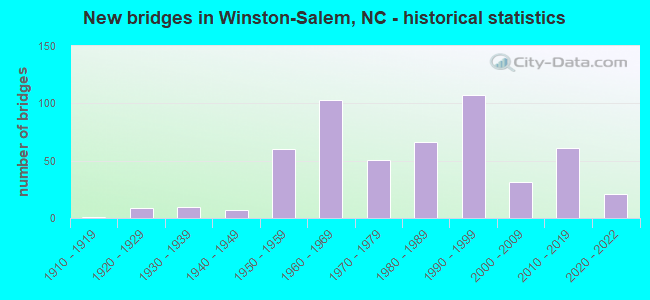
- New bridges - historical statistics
- 11910-1919
- 91920-1929
- 101930-1939
- 71940-1949
- 601950-1959
- 1031960-1969
- 511970-1979
- 661980-1989
- 1071990-1999
- 312000-2009
- 612010-2019
- 212020-2022

- Reconstructed bridges - Historical Statistics
- 11940-1949
- 21950-1959
- 11960-1969
- 11970-1979
- 81980-1989
- 171990-1999
- 72000-2009


- Bridge Condition - Deck
- 10.4%Very good
- 32.0%Good
- 32.5%Satisfactory
- 16.9%Fair
- 8.2%Poor

- Bridge Condition - Superstructure
- 1.7%Excellent
- 16.9%Very good
- 35.5%Good
- 21.6%Satisfactory
- 14.3%Fair
- 8.7%Poor
- 1.3%Serious

- Bridge Condition - Substructure
- 0.9%Excellent
- 10.8%Very good
- 37.7%Good
- 21.6%Satisfactory
- 23.4%Fair
- 5.6%Poor

- Bridge Condition - Channel
- 7.4%Very good
- 59.3%Good
- 24.1%Satisfactory
- 6.8%Fair
- 2.5%Poor

- Bridge Condition - Culverts
- 19.0%Good
- 51.9%Satisfactory
- 21.5%Fair
- 7.6%Poor
Find on map >> Show street view
Structure Number: 67022, Location: 0.8 MI. S. JCT. NC67 (Lat: 36.077383, Lng: -80.316528), Route carried "under" structure: Business Interstate 40, Year Built: 1959, Structure Length: 0. m, Average Daily Traffic: 35,000 (year 2013), Truck Traffic: 12%, Features Intersected: OLD VINEYARD RD SW
Minimum Vertical Clearance: 6.09m (19.98ft), Kilometerpoint: 0.192, Lanes on structure: 2, Lanes under structure: 3, Material/Design: Steel, Design/Construction: Stringer/Multi-beam, Length of Maximum Span: 23.1m (75.8ft)
Find on map >> Show street view
Structure Number: 67022, Location: 0.8 MI. S. JCT. NC67 (Lat: 36.077383, Lng: -80.316528), Route carried "under" structure: Business Interstate 40, Year Built: 1959, Structure Length: 0. m, Average Daily Traffic: 35,000 (year 2013), Truck Traffic: 12%, Features Intersected: OLD VINEYARD RD SW
Minimum Vertical Clearance: 4.91m (16.11ft), Kilometerpoint: 0.192, Lanes on structure: 2, Lanes under structure: 3, Material/Design: Steel, Design/Construction: Stringer/Multi-beam, Length of Maximum Span: 23.1m (75.8ft)
Find on map >> Show street view
Structure Number: 670224, Location: 1.2 MI. N. JCT. I40 (Lat: 36.108433, Lng: -80.236344), Route carried "under" structure: State highway 2456, Year Built: 1964, Structure Length: 0. m, Average Daily Traffic: 5,200 (year 2013), Truck Traffic: 7%, Features Intersected: US52 & NC8
Minimum Vertical Clearance: 4.54m (14.90ft), Kilometerpoint: 0.000, Lanes on structure: 4, Lanes under structure: 2, Material/Design: Steel, Design/Construction: Stringer/Multi-beam, Length of Maximum Span: 24.9m (81.7ft)
Find on map >> Show street view
Structure Number: 670226, Location: 2.87 MI.N.JCT.SR1103 (Lat: 36.072811, Lng: -80.357697), Route carried "under" structure: US 421, Year Built: 2019, Structure Length: 0. m, Average Daily Traffic: 31,000 (year 2017), Truck Traffic: 12%, Features Intersected: SR1891
Minimum Vertical Clearance: 6.18m (20.28ft), Kilometerpoint: 73.152, Lanes on structure: 3, Lanes under structure: 4, Material/Design: Prestressed concrete, Design/Construction: Stringer/Multi-beam, Length of Maximum Span: 36.2m (118.8ft)
Find on map >> Show street view
Structure Number: 670226, Location: 2.87 MI.N.JCT.SR1103 (Lat: 36.072811, Lng: -80.357697), Route carried "under" structure: US 421, Year Built: 2019, Structure Length: 0. m, Average Daily Traffic: 31,000 (year 2017), Truck Traffic: 12%, Features Intersected: SR1891
Minimum Vertical Clearance: 6.58m (21.59ft), Kilometerpoint: 73.152, Lanes on structure: 3, Lanes under structure: 3, Material/Design: Prestressed concrete, Design/Construction: Stringer/Multi-beam, Length of Maximum Span: 36.2m (118.8ft)
Find on map >> Show street view
Structure Number: 670227, Location: 0.5 MI. W. JCT. US158 (Lat: 36.083919, Lng: -80.306733), Route carried "under" structure: Business Interstate 40, Year Built: 1959, Structure Length: 0. m, Average Daily Traffic: 35,000 (year 2013), Truck Traffic: 12%, Features Intersected: NC67, Facility Carried by Structure: US421 N
Minimum Vertical Clearance: 4.83m (15.85ft), Kilometerpoint: 72.268, Lanes on structure: 6, Lanes under structure: 3, Material/Design: Prestressed concrete, Design/Construction: Stringer/Multi-beam, Length of Maximum Span: 19.5m (64.0ft)
Find on map >> Show street view
Structure Number: 670227, Location: 0.5 MI. W. JCT. US158 (Lat: 36.083919, Lng: -80.306733), Route carried "under" structure: Ramp Interstate 40, Year Built: 1959, Structure Length: 0. m, Average Daily Traffic: 16,500 (year 2012), Truck Traffic: 12%, Features Intersected: NC67, Facility Carried by Structure: US421 S RAMP
Minimum Vertical Clearance: 5.08m (16.67ft), Kilometerpoint: 72.268, Lanes on structure: 6, Lanes under structure: 2, Material/Design: Prestressed concrete, Design/Construction: Stringer/Multi-beam, Length of Maximum Span: 19.5m (64.0ft)
Find on map >> Show street view
Structure Number: 670227, Location: 0.5 MI. W. JCT. US158 (Lat: 36.083919, Lng: -80.306733), Route carried "under" structure: Business Interstate 40, Year Built: 1959, Structure Length: 0. m, Average Daily Traffic: 35,000 (year 2013), Truck Traffic: 12%, Features Intersected: NC67, Facility Carried by Structure: US421 S
Minimum Vertical Clearance: 4.93m (16.17ft), Kilometerpoint: 72.268, Lanes on structure: 6, Lanes under structure: 2, Material/Design: Prestressed concrete, Design/Construction: Stringer/Multi-beam, Length of Maximum Span: 19.5m (64.0ft)
Find on map >> Show street view
Structure Number: 670232, Location: 1.3 MI. N. JCT. I40 BUS (Lat: 36.109167, Lng: -80.236389), Route carried "under" structure: City street , Year Built: 1963, Structure Length: 0. m, Average Daily Traffic: 6,300 (year 2015), Truck Traffic: 7%, Features Intersected: US52, Facility Carried by Structure: LIBERTY STREET CON
Minimum Vertical Clearance: 4.49m (14.73ft), Kilometerpoint: 0.000, Lanes on structure: 4, Lanes under structure: 3, Material/Design: Steel, Design/Construction: Stringer/Multi-beam, Length of Maximum Span: 20.7m (67.9ft)
Find on map >> Show street view
Structure Number: 670237, Location: 1.3 MI. N. JCT. I40 (Lat: 36.111889, Lng: -80.236536), Route carried "under" structure: City street , Year Built: 1963, Structure Length: 0. m, Average Daily Traffic: 4,000 (year 2015), Truck Traffic: 7%, Features Intersected: US52 & NC8, Facility Carried by Structure: NORTHWEST BLVD.
Minimum Vertical Clearance: 4.77m (15.65ft), Kilometerpoint: 0.000, Lanes on structure: 4, Lanes under structure: 2, Material/Design: Steel, Design/Construction: Stringer/Multi-beam, Length of Maximum Span: 23.4m (76.8ft)
Find on map >> Show street view
Structure Number: 670239, Location: 0.75 MI. W. JCT. I40 (Lat: 36.072617, Lng: -80.338514), Route carried "under" structure: US 421, Year Built: 1992, Structure Length: 0. m, Average Daily Traffic: 27,500 (year 2013), Truck Traffic: 12%, Features Intersected: SR1122
Minimum Vertical Clearance: 5.38m (17.65ft), Kilometerpoint: 72.610, Lanes on structure: 6, Lanes under structure: 3, Material/Design: Steel, Design/Construction: Stringer/Multi-beam, Length of Maximum Span: 25.9m (85.0ft)
Find on map >> Show street view
Structure Number: 670239, Location: 0.75 MI. W. JCT. I40 (Lat: 36.072617, Lng: -80.338514), Route carried "under" structure: US 421, Year Built: 1992, Structure Length: 0. m, Average Daily Traffic: 27,500 (year 2013), Truck Traffic: 12%, Features Intersected: SR1122
Minimum Vertical Clearance: 5.33m (17.49ft), Kilometerpoint: 72.610, Lanes on structure: 6, Lanes under structure: 4, Material/Design: Steel, Design/Construction: Stringer/Multi-beam, Length of Maximum Span: 25.9m (85.0ft)
Find on map >> Show street view
Structure Number: 670243, Location: 0.1 MI. N. JCT. NC67 (Lat: 36.067550, Lng: -80.257981), Route carried "under" structure: State highway 150, Year Built: 1956, Structure Length: 0. m, Average Daily Traffic: 12,500 (year 2013), Truck Traffic: 12%, Features Intersected: OLD SALISBURY RD.
Minimum Vertical Clearance: 10.05m (32.97ft), Kilometerpoint: 0.000, Lanes on structure: 2, Lanes under structure: 3, Material/Design: Steel, Design/Construction: Stringer/Multi-beam, Length of Maximum Span: 16.4m (53.8ft)
Find on map >> Show street view
Structure Number: 670243, Location: 0.1 MI. N. JCT. NC67 (Lat: 36.067550, Lng: -80.257981), Route carried "under" structure: State highway 150, Year Built: 1956, Structure Length: 0. m, Average Daily Traffic: 12,500 (year 2013), Truck Traffic: 12%, Features Intersected: OLD SALISBURY RD.
Minimum Vertical Clearance: 9.44m (30.97ft), Kilometerpoint: 0.000, Lanes on structure: 2, Lanes under structure: 3, Material/Design: Steel, Design/Construction: Stringer/Multi-beam, Length of Maximum Span: 16.4m (53.8ft)
Find on map >> Show street view
Structure Number: 670244, Location: 0.2 MI. E. JCT. SR1801 (Lat: 36.114667, Lng: -80.236025), Route carried "under" structure: US 52, Year Built: 1964, Structure Length: 0. m, Average Daily Traffic: 39,500 (year 2015), Truck Traffic: 12%, Features Intersected: SIXTEENTH STREET
Minimum Vertical Clearance: 4.63m (15.19ft), Kilometerpoint: 33.561, Lanes on structure: 2, Lanes under structure: 2, Material/Design: Steel, Design/Construction: Stringer/Multi-beam, Length of Maximum Span: 16.1m (52.8ft)
Find on map >> Show street view
Structure Number: 670244, Location: 0.2 MI. E. JCT. SR1801 (Lat: 36.114667, Lng: -80.236025), Route carried "under" structure: US 52, Year Built: 1964, Structure Length: 0. m, Average Daily Traffic: 39,500 (year 2015), Truck Traffic: 12%, Features Intersected: SIXTEENTH STREET
Minimum Vertical Clearance: 4.71m (15.45ft), Kilometerpoint: 33.561, Lanes on structure: 2, Lanes under structure: 3, Material/Design: Steel, Design/Construction: Stringer/Multi-beam, Length of Maximum Span: 16.1m (52.8ft)
Find on map >> Show street view
Structure Number: 670245, Location: 0.7 MI. N. JCT. US158 (Lat: 36.090386, Lng: -80.290256), Route carried "under" structure: Business Interstate 40, Year Built: 1956, Structure Length: 0. m, Average Daily Traffic: 28,750 (year 2018), Truck Traffic: 12%, Features Intersected: WESTVIEW DRIVE
Minimum Vertical Clearance: 4.87m (15.98ft), Kilometerpoint: 0.725, Lanes on structure: 2, Lanes under structure: 2, Material/Design: Steel, Design/Construction: Stringer/Multi-beam, Length of Maximum Span: 18.2m (59.7ft)
Find on map >> Show street view
Structure Number: 670245, Location: 0.7 MI. N. JCT. US158 (Lat: 36.090386, Lng: -80.290256), Route carried "under" structure: Business Interstate 40, Year Built: 1956, Structure Length: 0. m, Average Daily Traffic: 28,750 (year 2018), Truck Traffic: 12%, Features Intersected: WESTVIEW DRIVE
Minimum Vertical Clearance: 4.58m (15.03ft), Kilometerpoint: 0.725, Lanes on structure: 2, Lanes under structure: 2, Material/Design: Steel, Design/Construction: Stringer/Multi-beam, Length of Maximum Span: 18.2m (59.7ft)
Find on map >> Show street view
Structure Number: 670247, Location: 1.7 MI. N. JCT. I40 BUS. (Lat: 36.117433, Lng: -80.235108), Route carried "under" structure: US 52, Year Built: 1964, Structure Length: 0. m, Average Daily Traffic: 39,000 (year 2013), Truck Traffic: 12%, Features Intersected: SR2456
Minimum Vertical Clearance: 5.22m (17.13ft), Kilometerpoint: 33.625, Lanes on structure: 2, Lanes under structure: 2, Material/Design: Concrete, Design/Construction: Box Beam or Girders - Multiple, Length of Maximum Span: 19.5m (64.0ft)
Find on map >> Show street view
Structure Number: 670247, Location: 1.7 MI. N. JCT. I40 BUS. (Lat: 36.117433, Lng: -80.235108), Route carried "under" structure: US 52, Year Built: 1964, Structure Length: 0. m, Average Daily Traffic: 39,000 (year 2013), Truck Traffic: 12%, Features Intersected: SR2456
Minimum Vertical Clearance: 5.97m (19.59ft), Kilometerpoint: 33.625, Lanes on structure: 2, Lanes under structure: 2, Material/Design: Concrete, Design/Construction: Box Beam or Girders - Multiple, Length of Maximum Span: 19.5m (64.0ft)
Find on map >> Show street view
Structure Number: 670248, Location: 0.5 MI. N. JCT. US158 (Lat: 36.091992, Lng: -80.286647), Route carried "under" structure: Business Interstate 40, Year Built: 1956, Structure Length: 0. m, Average Daily Traffic: 29,500 (year 2013), Truck Traffic: 12%, Features Intersected: KNOLLWOOD
Minimum Vertical Clearance: 4.70m (15.42ft), Kilometerpoint: 0.792, Lanes on structure: 4, Lanes under structure: 2, Material/Design: Steel, Design/Construction: Stringer/Multi-beam, Length of Maximum Span: 14.6m (47.9ft)
Find on map >> Show street view
Structure Number: 670248, Location: 0.5 MI. N. JCT. US158 (Lat: 36.091992, Lng: -80.286647), Route carried "under" structure: Business Interstate 40, Year Built: 1956, Structure Length: 0. m, Average Daily Traffic: 29,500 (year 2013), Truck Traffic: 12%, Features Intersected: KNOLLWOOD
Minimum Vertical Clearance: 4.83m (15.85ft), Kilometerpoint: 0.792, Lanes on structure: 4, Lanes under structure: 2, Material/Design: Steel, Design/Construction: Stringer/Multi-beam, Length of Maximum Span: 14.6m (47.9ft)
Find on map >> Show street view
Structure Number: 670249, Location: 0.6 MI. E. JCT. SR1122 (Lat: 36.071992, Lng: -80.327453), Route carried "under" structure: Business Interstate 40, Year Built: 1992, Structure Length: 0. m, Average Daily Traffic: 36,500 (year 2015), Truck Traffic: 16%, Features Intersected: US421 SBL
Minimum Vertical Clearance: 5.31m (17.42ft), Kilometerpoint: 0.000, Lanes on structure: 2, Lanes under structure: 2, Material/Design: Steel continuous, Design/Construction: Stringer/Multi-beam, Length of Maximum Span: 48.4m (158.8ft)
Find on map >> Show street view
Structure Number: 670253, Location: 0.3 MI. S. JCT. SR2456 (Lat: 36.122042, Lng: -80.232169), Route carried "under" structure: City street , Year Built: 1964, Structure Length: 0. m, Average Daily Traffic: 3,400 (year 2013), Truck Traffic: 7%, Features Intersected: US52, Facility Carried by Structure: TWENTYFIFTH ST.
Minimum Vertical Clearance: 4.41m (14.47ft), Kilometerpoint: 0.000, Lanes on structure: 4, Lanes under structure: 2, Material/Design: Steel, Design/Construction: Stringer/Multi-beam, Length of Maximum Span: 15.2m (49.9ft)
Find on map >> Show street view
Structure Number: 670254, Location: 0.3 MI. E. JCT.US158 (Lat: 36.093100, Lng: -80.274286), Route carried "under" structure: City street , Year Built: 1956, Structure Length: 0. m, Average Daily Traffic: 16,000 (year 2011), Truck Traffic: 7%, Features Intersected: I40 BUS, Facility Carried by Structure: MILLER...
Minimum Vertical Clearance: 6.58m (21.59ft), Kilometerpoint: 0.000, Lanes on structure: 4, Lanes under structure: 4, Material/Design: Steel, Design/Construction: Stringer/Multi-beam, Length of Maximum Span: 21.0m (68.9ft)
Find on map >> Show street view
Structure Number: 670255, Location: 0.2 MI. S. JCT. SR2456 (Lat: 36.123833, Lng: -80.232108), Route carried "under" structure: City street , Year Built: 1964, Structure Length: 0. m, Average Daily Traffic: 2,400 (year 2011), Truck Traffic: 7%, Features Intersected: US52, Facility Carried by Structure: CITYSTE
Minimum Vertical Clearance: 4.97m (16.31ft), Kilometerpoint: 0.000, Lanes on structure: 6, Lanes under structure: 2, Material/Design: Steel, Design/Construction: Stringer/Multi-beam, Length of Maximum Span: 28.0m (91.9ft)
Find on map >> Show street view
Structure Number: 670255, Location: 0.2 MI. S. JCT. SR2456 (Lat: 36.123833, Lng: -80.232108), Route carried "under" structure: City street , Year Built: 1964, Structure Length: 0. m, Average Daily Traffic: 2,400 (year 2011), Truck Traffic: 7%, Features Intersected: US52, Facility Carried by Structure: CITYST.W
Minimum Vertical Clearance: 4.63m (15.19ft), Kilometerpoint: 0.000, Lanes on structure: 6, Lanes under structure: 2, Material/Design: Steel, Design/Construction: Stringer/Multi-beam, Length of Maximum Span: 28.0m (91.9ft)
Find on map >> Show street view
Structure Number: 670256, Location: 0.9 MI. S. JCT. SR2264 (Lat: 36.127181, Lng: -80.233208), Route carried "under" structure: State highway 2456, Year Built: 2012, Structure Length: 0. m, Average Daily Traffic: 9,800 (year 2015), Truck Traffic: 7%, Features Intersected: US52 NBL
Minimum Vertical Clearance: 8.81m (28.90ft), Kilometerpoint: 0.000, Lanes on structure: 3, Lanes under structure: 4, Material/Design: Steel continuous, Design/Construction: Stringer/Multi-beam, Length of Maximum Span: 63.7m (209.0ft)
Find on map >> Show street view
Structure Number: 670257, Location: 0.9 MI. S. JCT. SR2264 (Lat: 36.127047, Lng: -80.233253), Route carried "under" structure: State highway 2456, Year Built: 2012, Structure Length: 0. m, Average Daily Traffic: 9,500 (year 2015), Truck Traffic: 7%, Features Intersected: US52 SBL
Minimum Vertical Clearance: 6.62m (21.72ft), Kilometerpoint: 0.000, Lanes on structure: 3, Lanes under structure: 4, Material/Design: Steel continuous, Design/Construction: Stringer/Multi-beam, Length of Maximum Span: 62.4m (204.7ft)
Find on map >> Show street view
Structure Number: 670259, Location: 0.7 MI. E. JCT. US158 (Lat: 36.091878, Lng: -80.267314), Route carried "under" structure: City street , Year Built: 2000, Structure Length: 0. m, Average Daily Traffic: 8,800 (year 2011), Truck Traffic: 7%, Features Intersected: I40 BUS,US421, Facility Carried by Structure: HAWTHORNEROAD,N
Minimum Vertical Clearance: 5.34m (17.52ft), Kilometerpoint: 0.000, Lanes on structure: 4, Lanes under structure: 4, Material/Design: Prestressed concrete, Design/Construction: Stringer/Multi-beam, Length of Maximum Span: 30.7m (100.7ft)
Find on map >> Show street view
Structure Number: 670259, Location: 0.7 MI. E. JCT. US158 (Lat: 36.091878, Lng: -80.267314), Route carried "under" structure: City street , Year Built: 2000, Structure Length: 0. m, Average Daily Traffic: 1,000 (year 2011), Truck Traffic: 7%, Features Intersected: I40 BUS,US421, Facility Carried by Structure: EDENTERRACEST.
Minimum Vertical Clearance: 7.01m (23.00ft), Kilometerpoint: 0.000, Lanes on structure: 4, Lanes under structure: 2, Material/Design: Prestressed concrete, Design/Construction: Stringer/Multi-beam, Length of Maximum Span: 30.7m (100.7ft)
Find on map >> Show street view
Structure Number: 670259, Location: 0.7 MI. E. JCT. US158 (Lat: 36.091878, Lng: -80.267314), Route carried "under" structure: City street , Year Built: 2000, Structure Length: 0. m, Average Daily Traffic: 14,000 (year 2011), Truck Traffic: 7%, Features Intersected: I40 BUS,US421, Facility Carried by Structure: CLOVERDALE AVE.
Minimum Vertical Clearance: 7.58m (24.87ft), Kilometerpoint: 0.000, Lanes on structure: 4, Lanes under structure: 3, Material/Design: Prestressed concrete, Design/Construction: Stringer/Multi-beam, Length of Maximum Span: 30.7m (100.7ft)
Find on map >> Show street view
Structure Number: 670263, Location: 0.3 MI. S. JCT. SR2264 (Lat: 36.133381, Lng: -80.238347), Route carried "under" structure: City street , Year Built: 1964, Structure Length: 0. m, Average Daily Traffic: 3,600 (year 2015), Truck Traffic: 7%, Features Intersected: US52, Facility Carried by Structure: GLENNAVENUE
Minimum Vertical Clearance: 4.45m (14.60ft), Kilometerpoint: 0.000, Lanes on structure: 4, Lanes under structure: 2, Material/Design: Steel, Design/Construction: Stringer/Multi-beam, Length of Maximum Span: 25.2m (82.7ft)
Find on map >> Show street view
Structure Number: 670264, Location: 1.2 MI. E. JCT. US158 (Lat: 36.089183, Lng: -80.260131), Route carried "under" structure: City street , Year Built: 1955, Structure Length: 0. m, Average Daily Traffic: 150 (year 1979), Truck Traffic: 7%, Features Intersected: I40 BUS, Facility Carried by Structure: CRAFTON STREET
Minimum Vertical Clearance: 4.82m (15.81ft), Kilometerpoint: 1.277, Lanes on structure: 5, Lanes under structure: 2, Material/Design: Steel, Design/Construction: Stringer/Multi-beam, Length of Maximum Span: 15.8m (51.8ft)
Find on map >> Show street view
Structure Number: 670265, Location: 0.7 MI. W. JCT. SR2456 (Lat: 36.138114, Lng: -80.239356), Route carried "under" structure: US 52, Year Built: 1964, Structure Length: 0. m, Average Daily Traffic: 38,500 (year 2017), Truck Traffic: 12%, Features Intersected: SR2264
Minimum Vertical Clearance: 4.53m (14.86ft), Kilometerpoint: 34.104, Lanes on structure: 4, Lanes under structure: 2, Material/Design: Steel, Design/Construction: Stringer/Multi-beam, Length of Maximum Span: 19.8m (65.0ft)
Find on map >> Show street view
Structure Number: 670265, Location: 0.7 MI. W. JCT. SR2456 (Lat: 36.138114, Lng: -80.239356), Route carried "under" structure: US 52, Year Built: 1964, Structure Length: 0. m, Average Daily Traffic: 37,750 (year 2019), Truck Traffic: 12%, Features Intersected: SR2264
Minimum Vertical Clearance: 4.70m (15.42ft), Kilometerpoint: 34.104, Lanes on structure: 4, Lanes under structure: 2, Material/Design: Steel, Design/Construction: Stringer/Multi-beam, Length of Maximum Span: 19.8m (65.0ft)
Find on map >> Show street view
Structure Number: 670267, Location: 0.7 MI. N. JCT. SR2264 (Lat: 36.148158, Lng: -80.244114), Route carried "under" structure: State highway 1825, Year Built: 1962, Structure Length: 0. m, Average Daily Traffic: 11,000 (year 2017), Truck Traffic: 7%, Features Intersected: US52 NBL
Minimum Vertical Clearance: 7.21m (23.65ft), Kilometerpoint: 0.000, Lanes on structure: 2, Lanes under structure: 3, Material/Design: Steel, Design/Construction: Stringer/Multi-beam, Length of Maximum Span: 19.5m (64.0ft)
Find on map >> Show street view
Structure Number: 670268, Location: 0.7 MI. N. JCT. SR2264 (Lat: 36.147958, Lng: -80.244122), Route carried "under" structure: State highway 1825, Year Built: 1962, Structure Length: 0. m, Average Daily Traffic: 8,100 (year 2013), Truck Traffic: 7%, Features Intersected: US52 SBL
Minimum Vertical Clearance: 7.06m (23.16ft), Kilometerpoint: 0.000, Lanes on structure: 3, Lanes under structure: 3, Material/Design: Steel, Design/Construction: Stringer/Multi-beam, Length of Maximum Span: 19.5m (64.0ft)
Find on map >> Show street view
Structure Number: 67027, Location: 0.8 MI. S. JCT. SR1725 (Lat: 36.155494, Lng: -80.252847), Route carried "under" structure: State highway 1733, Year Built: 1962, Structure Length: 0. m, Average Daily Traffic: 3,800 (year 2013), Truck Traffic: 7%, Features Intersected: US52 NBL
Minimum Vertical Clearance: 5.02m (16.47ft), Kilometerpoint: 0.000, Lanes on structure: 2, Lanes under structure: 2, Material/Design: Prestressed concrete, Design/Construction: Stringer/Multi-beam, Length of Maximum Span: 19.8m (65.0ft)
Find on map >> Show street view
Structure Number: 670271, Location: 0.8 MI. S. JCT. SR1725 (Lat: 36.155308, Lng: -80.252944), Route carried "under" structure: State highway 1733, Year Built: 1962, Structure Length: 0. m, Average Daily Traffic: 3,800 (year 2013), Truck Traffic: 7%, Features Intersected: US52 SBL
Minimum Vertical Clearance: 4.37m (14.34ft), Kilometerpoint: 0.000, Lanes on structure: 2, Lanes under structure: 2, Material/Design: Prestressed concrete, Design/Construction: Stringer/Multi-beam, Length of Maximum Span: 20.1m (65.9ft)
Find on map >> Show street view
Structure Number: 670275, Location: 0.2 MI. E. JCT. SR1372 (Lat: 36.112842, Lng: -80.305297), Route carried "under" structure: State highway 67, Year Built: 1963, Structure Length: 0. m, Average Daily Traffic: 21,000 (year 2017), Truck Traffic: 12%, Features Intersected: ROBINHOOD ROAD
Minimum Vertical Clearance: 4.85m (15.91ft), Kilometerpoint: 0.000, Lanes on structure: 4, Lanes under structure: 2, Material/Design: Steel, Design/Construction: Stringer/Multi-beam, Length of Maximum Span: 14.0m (45.9ft)
Find on map >> Show street view
Structure Number: 670275, Location: 0.2 MI. E. JCT. SR1372 (Lat: 36.112842, Lng: -80.305297), Route carried "under" structure: State highway 67, Year Built: 1963, Structure Length: 0. m, Average Daily Traffic: 21,000 (year 2017), Truck Traffic: 12%, Features Intersected: ROBINHOOD ROAD
Minimum Vertical Clearance: 5.00m (16.40ft), Kilometerpoint: 0.000, Lanes on structure: 4, Lanes under structure: 2, Material/Design: Steel, Design/Construction: Stringer/Multi-beam, Length of Maximum Span: 14.0m (45.9ft)
Find on map >> Show street view
Structure Number: 670276, Location: 1.3MI.W.JCT.KNOLLWOOD ST (Lat: 36.092283, Lng: -80.309492), Route carried "under" structure: State highway 67, Year Built: 1960, Structure Length: 0. m, Average Daily Traffic: 27,000 (year 2013), Truck Traffic: 12%, Features Intersected: SR1001
Minimum Vertical Clearance: 4.44m (14.57ft), Kilometerpoint: 0.000, Lanes on structure: 3, Lanes under structure: 3, Material/Design: Steel, Design/Construction: Stringer/Multi-beam, Length of Maximum Span: 12.4m (40.7ft)
Find on map >> Show street view
Structure Number: 670276, Location: 1.3MI.W.JCT.KNOLLWOOD ST (Lat: 36.092283, Lng: -80.309492), Route carried "under" structure: State highway 67, Year Built: 1960, Structure Length: 0. m, Average Daily Traffic: 27,000 (year 2013), Truck Traffic: 12%, Features Intersected: SR1001
Minimum Vertical Clearance: 4.62m (15.16ft), Kilometerpoint: 0.000, Lanes on structure: 3, Lanes under structure: 2, Material/Design: Steel, Design/Construction: Stringer/Multi-beam, Length of Maximum Span: 12.4m (40.7ft)
Find on map >> Show street view
Structure Number: 670277, Location: 0.4MI.W.JCT.SHERWDFRST RD (Lat: 36.097767, Lng: -80.309069), Route carried "under" structure: State highway 67, Year Built: 1960, Structure Length: 0. m, Average Daily Traffic: 27,000 (year 2013), Truck Traffic: 12%, Features Intersected: NOTTINGHAM ROAD
Minimum Vertical Clearance: 4.52m (14.83ft), Kilometerpoint: 0.000, Lanes on structure: 2, Lanes under structure: 2, Material/Design: Steel, Design/Construction: Stringer/Multi-beam, Length of Maximum Span: 12.4m (40.7ft)
Find on map >> Show street view
Structure Number: 670277, Location: 0.4MI.W.JCT.SHERWDFRST RD (Lat: 36.097767, Lng: -80.309069), Route carried "under" structure: State highway 67, Year Built: 1960, Structure Length: 0. m, Average Daily Traffic: 28,000 (year 2011), Truck Traffic: 12%, Features Intersected: NOTTINGHAM ROAD
Minimum Vertical Clearance: 4.72m (15.49ft), Kilometerpoint: 0.000, Lanes on structure: 2, Lanes under structure: 2, Material/Design: Steel, Design/Construction: Stringer/Multi-beam, Length of Maximum Span: 12.4m (40.7ft)
Find on map >> Show street view
Structure Number: 670278, Location: 1.7 MI. N. JCT. I-40 (Lat: 36.089542, Lng: -80.257408), Route carried "under" structure: Business Interstate 40, Year Built: 2018, Structure Length: 0. m, Average Daily Traffic: 35,500 (year 2017), Truck Traffic: 12%, Features Intersected: NC150
Minimum Vertical Clearance: 7.42m (24.34ft), Kilometerpoint: 0.000, Lanes on structure: 4, Lanes under structure: 2, Material/Design: Prestressed concrete, Design/Construction: Stringer/Multi-beam, Length of Maximum Span: 25.9m (85.0ft)
Find on map >> Show street view
Structure Number: 670278, Location: 1.7 MI. N. JCT. I-40 (Lat: 36.089542, Lng: -80.257408), Route carried "under" structure: Business Interstate 40, Year Built: 2018, Structure Length: 0. m, Average Daily Traffic: 35,500 (year 2017), Truck Traffic: 12%, Features Intersected: NC150
Minimum Vertical Clearance: 6.09m (19.98ft), Kilometerpoint: 0.000, Lanes on structure: 4, Lanes under structure: 3, Material/Design: Prestressed concrete, Design/Construction: Stringer/Multi-beam, Length of Maximum Span: 25.9m (85.0ft)
Find on map >> Show street view
Structure Number: 670282, Location: 0.5 MI.W.JCT.NC8 (Lat: 36.173953, Lng: -80.268039), Route carried "under" structure: US 52, Year Built: 1962, Structure Length: 0. m, Average Daily Traffic: 48,000 (year 2015), Truck Traffic: 12%, Features Intersected: SR1686
Minimum Vertical Clearance: 5.27m (17.29ft), Kilometerpoint: 35.037, Lanes on structure: 2, Lanes under structure: 2, Material/Design: Steel, Design/Construction: Stringer/Multi-beam, Length of Maximum Span: 17.0m (55.8ft)
Find on map >> Show street view
Structure Number: 670284, Location: 1.1 MI. E. JCT. NC67 (Lat: 36.140028, Lng: -80.274472), Route carried "under" structure: State highway 4000, Year Built: 1968, Structure Length: 0. m, Average Daily Traffic: 6,000 (year 2015), Truck Traffic: 12%, Features Intersected: POLO ROAD
Minimum Vertical Clearance: 4.59m (15.06ft), Kilometerpoint: 0.000, Lanes on structure: 3, Lanes under structure: 2, Material/Design: Steel, Design/Construction: Stringer/Multi-beam, Length of Maximum Span: 15.5m (50.9ft)
Find on map >> Show street view
Structure Number: 670284, Location: 1.1 MI. E. JCT. NC67 (Lat: 36.140028, Lng: -80.274472), Route carried "under" structure: State highway 4000, Year Built: 1968, Structure Length: 0. m, Average Daily Traffic: 6,000 (year 2015), Truck Traffic: 12%, Features Intersected: POLO ROAD
Minimum Vertical Clearance: 4.77m (15.65ft), Kilometerpoint: 0.000, Lanes on structure: 3, Lanes under structure: 2, Material/Design: Steel, Design/Construction: Stringer/Multi-beam, Length of Maximum Span: 15.5m (50.9ft)
Find on map >> Show street view
Structure Number: 670288, Location: 0.4M. E. JCT. SR3013 (Lat: 36.092358, Lng: -80.249981), Route carried "under" structure: City street , Year Built: 2020, Structure Length: 0. m, Average Daily Traffic: 1,200 (year 2017), Truck Traffic: 7%, Features Intersected: I40 BUS, US421, Facility Carried by Structure: BROOKSTOWN AVENUE
Minimum Vertical Clearance: 5.71m (18.73ft), Kilometerpoint: 0.000, Lanes on structure: 6, Lanes under structure: 2, Material/Design: Prestressed concrete, Design/Construction: Stringer/Multi-beam, Length of Maximum Span: 21.0m (68.9ft)
Find on map >> Show street view
Structure Number: 670289, Location: 0.55 MI. E. JCT. SR1672 (Lat: 36.181217, Lng: -80.275344), Route carried "under" structure: US 52, Year Built: 1962, Structure Length: 0. m, Average Daily Traffic: 48,000 (year 2015), Truck Traffic: 12%, Features Intersected: SR4000
Minimum Vertical Clearance: 5.47m (17.95ft), Kilometerpoint: 35.241, Lanes on structure: 5, Lanes under structure: 2, Material/Design: Prestressed concrete, Design/Construction: Stringer/Multi-beam, Length of Maximum Span: 21.3m (69.9ft)
Find on map >> Show street view
Structure Number: 670289, Location: 0.55 MI. E. JCT. SR1672 (Lat: 36.181217, Lng: -80.275344), Route carried "under" structure: US 52, Year Built: 1962, Structure Length: 0. m, Average Daily Traffic: 48,000 (year 2015), Truck Traffic: 12%, Features Intersected: SR4000
Minimum Vertical Clearance: 5.13m (16.83ft), Kilometerpoint: 35.241, Lanes on structure: 5, Lanes under structure: 3, Material/Design: Prestressed concrete, Design/Construction: Stringer/Multi-beam, Length of Maximum Span: 21.3m (69.9ft)
Find on map >> Show street view
Structure Number: 67029, Location: 0.2 MI. W. JCT. SR4000 (Lat: 36.187944, Lng: -80.279756), Route carried "under" structure: US 52, Year Built: 1962, Structure Length: 0. m, Average Daily Traffic: 25,000 (year 2013), Truck Traffic: 12%, Features Intersected: SR1672
Minimum Vertical Clearance: 4.79m (15.72ft), Kilometerpoint: 35.402, Lanes on structure: 2, Lanes under structure: 3, Material/Design: Prestressed concrete, Design/Construction: Stringer/Multi-beam, Length of Maximum Span: 19.2m (63.0ft)
Find on map >> Show street view
Structure Number: 67029, Location: 0.2 MI. W. JCT. SR4000 (Lat: 36.187944, Lng: -80.279756), Route carried "under" structure: US 52, Year Built: 1962, Structure Length: 0. m, Average Daily Traffic: 25,000 (year 2013), Truck Traffic: 12%, Features Intersected: SR1672
Minimum Vertical Clearance: 4.86m (15.94ft), Kilometerpoint: 35.402, Lanes on structure: 2, Lanes under structure: 2, Material/Design: Prestressed concrete, Design/Construction: Stringer/Multi-beam, Length of Maximum Span: 19.2m (63.0ft)
Find on map >> Show street view
Structure Number: 670292, Location: 0.7 MI. E. JCT. SR1669 (Lat: 36.195069, Lng: -80.288042), Route carried "under" structure: US 52, Year Built: 1962, Structure Length: 0. m, Average Daily Traffic: 25,000 (year 2013), Truck Traffic: 12%, Features Intersected: SR1669
Minimum Vertical Clearance: 5.16m (16.93ft), Kilometerpoint: 35.610, Lanes on structure: 2, Lanes under structure: 2, Material/Design: Steel, Design/Construction: Stringer/Multi-beam, Length of Maximum Span: 20.7m (67.9ft)
Find on map >> Show street view
Structure Number: 670292, Location: 0.7 MI. E. JCT. SR1669 (Lat: 36.195069, Lng: -80.288042), Route carried "under" structure: US 52, Year Built: 1962, Structure Length: 0. m, Average Daily Traffic: 25,000 (year 2013), Truck Traffic: 12%, Features Intersected: SR1669
Minimum Vertical Clearance: 5.98m (19.62ft), Kilometerpoint: 35.610, Lanes on structure: 2, Lanes under structure: 2, Material/Design: Steel, Design/Construction: Stringer/Multi-beam, Length of Maximum Span: 20.7m (67.9ft)
Find on map >> Show street view
Structure Number: 670293, Location: 0.1M. N. JCT. SR4008 (Lat: 36.093100, Lng: -80.247092), Route carried "under" structure: Business Interstate 40, Year Built: 2020, Structure Length: 0. m, Average Daily Traffic: 30,250 (year 2018), Truck Traffic: 12%, Features Intersected: SR1770
Minimum Vertical Clearance: 5.41m (17.75ft), Kilometerpoint: 0.000, Lanes on structure: 3, Lanes under structure: 2, Material/Design: Prestressed concrete, Design/Construction: Stringer/Multi-beam, Length of Maximum Span: 30.1m (98.8ft)
Find on map >> Show street view
Structure Number: 670293, Location: 0.1M. N. JCT. SR4008 (Lat: 36.093100, Lng: -80.247092), Route carried "under" structure: Business Interstate 40, Year Built: 2020, Structure Length: 0. m, Average Daily Traffic: 30,250 (year 2018), Truck Traffic: 12%, Features Intersected: SR1770
Minimum Vertical Clearance: 5.86m (19.23ft), Kilometerpoint: 0.000, Lanes on structure: 3, Lanes under structure: 2, Material/Design: Prestressed concrete, Design/Construction: Stringer/Multi-beam, Length of Maximum Span: 30.1m (98.8ft)
Find on map >> Show street view
Structure Number: 670294, Location: 0.1MI.N.JCT.BURKE MILL RD (Lat: 36.070056, Lng: -80.290219), Route carried "under" structure: State highway 67, Year Built: 1968, Structure Length: 0. m, Average Daily Traffic: 13,000 (year 2013), Truck Traffic: 6%, Features Intersected: BOLTON STREET
Minimum Vertical Clearance: 4.64m (15.22ft), Kilometerpoint: 0.000, Lanes on structure: 2, Lanes under structure: 3, Material/Design: Steel, Design/Construction: Stringer/Multi-beam, Length of Maximum Span: 14.9m (48.9ft)
Find on map >> Show street view
Structure Number: 670294, Location: 0.1MI.N.JCT.BURKE MILL RD (Lat: 36.070056, Lng: -80.290219), Route carried "under" structure: State highway 67, Year Built: 1968, Structure Length: 0. m, Average Daily Traffic: 13,000 (year 2013), Truck Traffic: 6%, Features Intersected: BOLTON STREET
Minimum Vertical Clearance: 4.59m (15.06ft), Kilometerpoint: 0.000, Lanes on structure: 2, Lanes under structure: 3, Material/Design: Steel, Design/Construction: Stringer/Multi-beam, Length of Maximum Span: 14.9m (48.9ft)
Find on map >> Show street view
Structure Number: 670305, Location: 0.1 MI. N. JCT. SR4008 (Lat: 36.093322, Lng: -80.246261), Route carried "under" structure: Business Interstate 40, Year Built: 2020, Structure Length: 0. m, Average Daily Traffic: 30,250 (year 2018), Truck Traffic: 12%, Features Intersected: SR1725
Minimum Vertical Clearance: 5.51m (18.08ft), Kilometerpoint: 0.000, Lanes on structure: 3, Lanes under structure: 2, Material/Design: Prestressed concrete, Design/Construction: Stringer/Multi-beam, Length of Maximum Span: 34.7m (113.8ft)
Find on map >> Show street view
Structure Number: 670305, Location: 0.1 MI. N. JCT. SR4008 (Lat: 36.093322, Lng: -80.246261), Route carried "under" structure: Business Interstate 40, Year Built: 2020, Structure Length: 0. m, Average Daily Traffic: 30,250 (year 2018), Truck Traffic: 12%, Features Intersected: SR1725
Minimum Vertical Clearance: 5.84m (19.16ft), Kilometerpoint: 0.000, Lanes on structure: 3, Lanes under structure: 2, Material/Design: Prestressed concrete, Design/Construction: Stringer/Multi-beam, Length of Maximum Span: 34.7m (113.8ft)
Find on map >> Show street view
Structure Number: 670308, Location: 0.8 MI. W. JCT. NC66 (Lat: 36.203233, Lng: -80.295669), Route carried "under" structure: US 52, Year Built: 1964, Structure Length: 0. m, Average Daily Traffic: 28,250 (year 2018), Truck Traffic: 12%, Features Intersected: SR1840 NBL
Minimum Vertical Clearance: 4.98m (16.34ft), Kilometerpoint: 35.826, Lanes on structure: 1, Lanes under structure: 2, Material/Design: Steel, Design/Construction: Stringer/Multi-beam, Length of Maximum Span: 24.6m (80.7ft)
Find on map >> Show street view
Structure Number: 670312, Location: 0.75 MI. S. JCT. SR2516 (Lat: 36.093639, Lng: -80.244072), Route carried "under" structure: Business Interstate 40, Year Built: 2020, Structure Length: 0. m, Average Daily Traffic: 30,250 (year 2018), Truck Traffic: 12%, Features Intersected: SR4315
Minimum Vertical Clearance: 5.84m (19.16ft), Kilometerpoint: 71.019, Lanes on structure: 3, Lanes under structure: 3, Material/Design: Prestressed concrete, Design/Construction: Stringer/Multi-beam, Length of Maximum Span: 42.6m (139.8ft)
Find on map >> Show street view
Structure Number: 670312, Location: 0.75 MI. S. JCT. SR2516 (Lat: 36.093639, Lng: -80.244072), Route carried "under" structure: Business Interstate 40, Year Built: 2020, Structure Length: 0. m, Average Daily Traffic: 30,250 (year 2018), Truck Traffic: 12%, Features Intersected: SR4315
Minimum Vertical Clearance: 5.51m (18.08ft), Kilometerpoint: 71.019, Lanes on structure: 3, Lanes under structure: 3, Material/Design: Prestressed concrete, Design/Construction: Stringer/Multi-beam, Length of Maximum Span: 42.6m (139.8ft)
Find on map >> Show street view
Structure Number: 670313, Location: 0.8 MI. S. JCT. SR2516 (Lat: 36.093536, Lng: -80.243169), Route carried "under" structure: Alternate US , Year Built: 2019, Structure Length: 0. m, Average Daily Traffic: 30,250 (year 2018), Truck Traffic: 12%, Features Intersected: SR1824, Facility Carried by Structure: US 421 SB
Minimum Vertical Clearance: 6.83m (22.41ft), Kilometerpoint: 71.064, Lanes on structure: 2, Lanes under structure: 2, Material/Design: Prestressed concrete, Design/Construction: Stringer/Multi-beam, Length of Maximum Span: 37.4m (122.7ft)
Find on map >> Show street view
Structure Number: 670313, Location: 0.8 MI. S. JCT. SR2516 (Lat: 36.093536, Lng: -80.243169), Route carried "under" structure: Alternate US , Year Built: 2019, Structure Length: 0. m, Average Daily Traffic: 30,250 (year 2018), Truck Traffic: 12%, Features Intersected: SR1824, Facility Carried by Structure: US 421 NB
Minimum Vertical Clearance: 6.52m (21.39ft), Kilometerpoint: 71.064, Lanes on structure: 2, Lanes under structure: 2, Material/Design: Prestressed concrete, Design/Construction: Stringer/Multi-beam, Length of Maximum Span: 37.4m (122.7ft)
Find on map >> Show street view
Structure Number: 670321, Location: 1.0 MI. W. JCT. SR1725 (Lat: 36.155244, Lng: -80.278736), Route carried "under" structure: State highway 4000, Year Built: 1972, Structure Length: 0. m, Average Daily Traffic: 15,000 (year 2013), Truck Traffic: 12%, Features Intersected: INDIANA AVENUE
Minimum Vertical Clearance: 4.92m (16.14ft), Kilometerpoint: 0.000, Lanes on structure: 2, Lanes under structure: 3, Material/Design: Steel, Design/Construction: Stringer/Multi-beam, Length of Maximum Span: 39.0m (128.0ft)
Find on map >> Show street view
Structure Number: 670321, Location: 1.0 MI. W. JCT. SR1725 (Lat: 36.155244, Lng: -80.278736), Route carried "under" structure: State highway 4000, Year Built: 1972, Structure Length: 0. m, Average Daily Traffic: 15,000 (year 2013), Truck Traffic: 12%, Features Intersected: INDIANA AVENUE
Minimum Vertical Clearance: 5.33m (17.49ft), Kilometerpoint: 0.000, Lanes on structure: 2, Lanes under structure: 3, Material/Design: Steel, Design/Construction: Stringer/Multi-beam, Length of Maximum Span: 39.0m (128.0ft)
Find on map >> Show street view
Structure Number: 670322, Location: 1.0 MI. N. JCT. SR1508 (Lat: 36.117394, Lng: -80.256475), Route carried "under" structure: City street , Year Built: 2010, Structure Length: 0. m, Average Daily Traffic: 1,000 (year 2012), Truck Traffic: 7%, Features Intersected: SR1725, Facility Carried by Structure: TWENTIETH STREET
Minimum Vertical Clearance: 4.57m (14.99ft), Kilometerpoint: 0.000, Lanes on structure: 4, Lanes under structure: 2, Material/Design: Prestressed concrete, Design/Construction: Slab, Length of Maximum Span: 20.4m (66.9ft)
Find on map >> Show street view
Structure Number: 670323, Location: 0.4 MI. N. JCT. US52 (Lat: 36.061686, Lng: -80.225692), Route carried "under" structure: Interstate 40, Year Built: 1973, Structure Length: 0. m, Average Daily Traffic: 51,500 (year 2015), Truck Traffic: 16%, Features Intersected: OLD LEXINGTON ROAD
Minimum Vertical Clearance: 5.12m (16.80ft), Kilometerpoint: 59.070, Lanes on structure: 4, Lanes under structure: 4, Material/Design: Steel, Design/Construction: Stringer/Multi-beam, Length of Maximum Span: 21.6m (70.9ft)
Find on map >> Show street view
Structure Number: 670323, Location: 0.4 MI. N. JCT. US52 (Lat: 36.061686, Lng: -80.225692), Route carried "under" structure: Interstate 40, Year Built: 1973, Structure Length: 0. m, Average Daily Traffic: 51,500 (year 2015), Truck Traffic: 16%, Features Intersected: OLD LEXINGTON ROAD
Minimum Vertical Clearance: 5.51m (18.08ft), Kilometerpoint: 59.070, Lanes on structure: 4, Lanes under structure: 4, Material/Design: Steel, Design/Construction: Stringer/Multi-beam, Length of Maximum Span: 21.6m (70.9ft)
Find on map >> Show street view
Structure Number: 670336, Location: 300 FT.N.JCT.SR40008 (Lat: 36.093394, Lng: -80.242322), Route carried "under" structure: Alternate US 421, Year Built: 2019, Structure Length: 0. m, Average Daily Traffic: 22,687 (year 2018), Truck Traffic: 12%, Features Intersected: CHURCH STREET
Minimum Vertical Clearance: 10.13m (33.23ft), Kilometerpoint: 71.049, Lanes on structure: 2, Lanes under structure: 2, Material/Design: Prestressed concrete, Design/Construction: Stringer/Multi-beam, Length of Maximum Span: 30.4m (99.7ft)
Find on map >> Show street view
Structure Number: 670336, Location: 300 FT.N.JCT.SR40008 (Lat: 36.093394, Lng: -80.242322), Route carried "under" structure: Alternate US 421, Year Built: 2019, Structure Length: 0. m, Average Daily Traffic: 7,562 (year 2018), Truck Traffic: 12%, Features Intersected: CHURCH STREET
Minimum Vertical Clearance: 7.21m (23.65ft), Kilometerpoint: 71.049, Lanes on structure: 2, Lanes under structure: 1, Material/Design: Prestressed concrete, Design/Construction: Stringer/Multi-beam, Length of Maximum Span: 30.4m (99.7ft)
Find on map >> Show street view
Structure Number: 670336, Location: 300 FT.N.JCT.SR40008 (Lat: 36.093394, Lng: -80.242322), Route carried "under" structure: Alternate US 421, Year Built: 2019, Structure Length: 0. m, Average Daily Traffic: 7,563 (year 2018), Truck Traffic: 12%, Features Intersected: CHURCH STREET
Minimum Vertical Clearance: 5.58m (18.31ft), Kilometerpoint: 71.049, Lanes on structure: 2, Lanes under structure: 1, Material/Design: Prestressed concrete, Design/Construction: Stringer/Multi-beam, Length of Maximum Span: 30.4m (99.7ft)
Find on map >> Show street view
Structure Number: 670336, Location: 300 FT.N.JCT.SR40008 (Lat: 36.093394, Lng: -80.242322), Route carried "under" structure: Alternate US 421, Year Built: 2019, Structure Length: 0. m, Average Daily Traffic: 22,688 (year 2018), Truck Traffic: 12%, Features Intersected: CHURCH STREET
Minimum Vertical Clearance: 10.10m (33.14ft), Kilometerpoint: 71.049, Lanes on structure: 2, Lanes under structure: 2, Material/Design: Prestressed concrete, Design/Construction: Stringer/Multi-beam, Length of Maximum Span: 30.4m (99.7ft)
Find on map >> Show street view
Structure Number: 67034, Location: 0.4 MI. E. JCT. SR2743 (Lat: 36.060075, Lng: -80.219692), Route carried "under" structure: City street , Year Built: 1980, Structure Length: 0. m, Average Daily Traffic: 12,000 (year 2015), Truck Traffic: 7%, Features Intersected: I40 & US311, Facility Carried by Structure: CLEMMONSVILLE ROAD
Minimum Vertical Clearance: 5.13m (16.83ft), Kilometerpoint: 0.000, Lanes on structure: 6, Lanes under structure: 4, Material/Design: Steel, Design/Construction: Stringer/Multi-beam, Length of Maximum Span: 29.2m (95.8ft)
Find on map >> Show street view
Structure Number: 670341, Location: 1.1 MI. E. JCT. NC109 (Lat: 36.060281, Lng: -80.194694), Route carried "under" structure: City street , Year Built: 1980, Structure Length: 0. m, Average Daily Traffic: 3,800 (year 2019), Truck Traffic: 7%, Features Intersected: I40 EBL, US311 SBL, Facility Carried by Structure: WILLARD ROAD
Minimum Vertical Clearance: 8.38m (27.49ft), Kilometerpoint: 0.000, Lanes on structure: 3, Lanes under structure: 2, Material/Design: Prestressed concrete, Design/Construction: Stringer/Multi-beam, Length of Maximum Span: 22.8m (74.8ft)
Find on map >> Show street view
Structure Number: 670345, Location: 0.2 MI. W. JCT. US52 (Lat: 36.093361, Lng: -80.237350), Route carried "under" structure: City street , Year Built: 1998, Structure Length: 0. m, Average Daily Traffic: 1,200 (year 2013), Truck Traffic: 7%, Features Intersected: I40 BUS, US421, Facility Carried by Structure: RESEARCH PARKWAY
Minimum Vertical Clearance: 8.81m (28.90ft), Kilometerpoint: 0.000, Lanes on structure: 6, Lanes under structure: 4, Material/Design: Steel continuous, Design/Construction: Stringer/Multi-beam, Length of Maximum Span: 45.7m (149.9ft)
Find on map >> Show street view
Structure Number: 670345, Location: 0.2 MI. W. JCT. US52 (Lat: 36.093361, Lng: -80.237350), Route carried "under" structure: City street , Year Built: 1998, Structure Length: 0. m, Average Daily Traffic: 2,400 (year 2013), Truck Traffic: 7%, Features Intersected: I40 BUS, US421, Facility Carried by Structure: SALEM AVENUE
Minimum Vertical Clearance: 5.19m (17.03ft), Kilometerpoint: 0.000, Lanes on structure: 6, Lanes under structure: 2, Material/Design: Steel continuous, Design/Construction: Stringer/Multi-beam, Length of Maximum Span: 45.7m (149.9ft)
Find on map >> Show street view
Structure Number: 670348, Location: 0.3 MI.W. JCT. US311&NC8 (Lat: 36.094006, Lng: -80.232458), Route carried "under" structure: US 52, Year Built: 1958, Structure Length: 0. m, Average Daily Traffic: 38,500 (year 2013), Truck Traffic: 12%, Features Intersected: I40 BUS, US158/421
Minimum Vertical Clearance: 4.73m (15.52ft), Kilometerpoint: 33.110, Lanes on structure: 6, Lanes under structure: 3, Material/Design: Steel, Design/Construction: Stringer/Multi-beam, Length of Maximum Span: 17.9m (58.7ft)
Find on map >> Show street view
Structure Number: 670348, Location: 0.3 MI.W. JCT. US311&NC8 (Lat: 36.094006, Lng: -80.232458), Route carried "under" structure: US 52, Year Built: 1958, Structure Length: 0. m, Average Daily Traffic: 38,500 (year 2013), Truck Traffic: 12%, Features Intersected: I40 BUS, US158/421
Minimum Vertical Clearance: 4.84m (15.88ft), Kilometerpoint: 33.110, Lanes on structure: 6, Lanes under structure: 3, Material/Design: Steel, Design/Construction: Stringer/Multi-beam, Length of Maximum Span: 17.9m (58.7ft)
Find on map >> Show street view
Structure Number: 670355, Location: 0.8 MI. E. JCT. SR4325 (Lat: 36.095936, Lng: -80.214589), Route carried "under" structure: City street , Year Built: 1958, Structure Length: 0. m, Average Daily Traffic: 13,000 (year 2009), Truck Traffic: 7%, Features Intersected: I40 BUS, Facility Carried by Structure: LOWERY STREET
Minimum Vertical Clearance: 4.97m (16.31ft), Kilometerpoint: 2.103, Lanes on structure: 5, Lanes under structure: 4, Material/Design: Steel, Design/Construction: Stringer/Multi-beam, Length of Maximum Span: 15.5m (50.9ft)
Find on map >> Show street view
Structure Number: 670358, Location: 2.0 MI. E. JCT. US311 (Lat: 36.101925, Lng: -80.193478), Route carried "under" structure: US 158, Year Built: 2006, Structure Length: 0. m, Average Daily Traffic: 8,500 (year 2013), Truck Traffic: 12%, Features Intersected: I40 BUS WBL
Minimum Vertical Clearance: 5.28m (17.32ft), Kilometerpoint: 0.000, Lanes on structure: 2, Lanes under structure: 2, Material/Design: Prestressed concrete, Design/Construction: Stringer/Multi-beam, Length of Maximum Span: 23.7m (77.8ft)
Find on map >> Show street view
Structure Number: 670359, Location: 2.0 MI. E. JCT. US311 (Lat: 36.101564, Lng: -80.193664), Route carried "under" structure: US 158, Year Built: 2006, Structure Length: 0. m, Average Daily Traffic: 8,500 (year 2013), Truck Traffic: 12%, Features Intersected: I40 BUS EBL
Minimum Vertical Clearance: 5.76m (18.90ft), Kilometerpoint: 0.000, Lanes on structure: 2, Lanes under structure: 2, Material/Design: Prestressed concrete continuous, Design/Construction: Stringer/Multi-beam, Length of Maximum Span: 24.0m (78.7ft)
Find on map >> Show street view
Structure Number: 670364, Location: 0.1 MI. S. JCT. SR2377 (Lat: 36.111203, Lng: -80.164947), Route carried "under" structure: Business Interstate 40, Year Built: 1961, Structure Length: 0. m, Average Daily Traffic: 26,000 (year 2013), Truck Traffic: 12%, Features Intersected: SR2662
Minimum Vertical Clearance: 5.48m (17.98ft), Kilometerpoint: 3.017, Lanes on structure: 2, Lanes under structure: 3, Material/Design: Steel, Design/Construction: Stringer/Multi-beam, Length of Maximum Span: 24.3m (79.7ft)
Find on map >> Show street view
Structure Number: 670364, Location: 0.1 MI. S. JCT. SR2377 (Lat: 36.111203, Lng: -80.164947), Route carried "under" structure: Business Interstate 40, Year Built: 1961, Structure Length: 0. m, Average Daily Traffic: 26,000 (year 2013), Truck Traffic: 12%, Features Intersected: SR2662
Minimum Vertical Clearance: 5.11m (16.77ft), Kilometerpoint: 3.017, Lanes on structure: 2, Lanes under structure: 3, Material/Design: Steel, Design/Construction: Stringer/Multi-beam, Length of Maximum Span: 24.3m (79.7ft)
Find on map >> Show street view
Structure Number: 670366, Location: 0.7 MI. S. JCT. SR2377 (Lat: 36.113411, Lng: -80.142286), Route carried "under" structure: Business Interstate 40, Year Built: 2014, Structure Length: 0. m, Average Daily Traffic: 5,000 (year 2018), Truck Traffic: 16%, Features Intersected: SR2667
Minimum Vertical Clearance: 5.94m (19.49ft), Kilometerpoint: 0.000, Lanes on structure: 2, Lanes under structure: 2, Material/Design: Prestressed concrete continuous, Design/Construction: Stringer/Multi-beam, Length of Maximum Span: 34.4m (112.9ft)
Find on map >> Show street view
Structure Number: 670366, Location: 0.7 MI. S. JCT. SR2377 (Lat: 36.113411, Lng: -80.142286), Route carried "under" structure: Business Interstate 40, Year Built: 2014, Structure Length: 0. m, Average Daily Traffic: 5,000 (year 2018), Truck Traffic: 16%, Features Intersected: SR2667
Minimum Vertical Clearance: 6.22m (20.41ft), Kilometerpoint: 0.000, Lanes on structure: 2, Lanes under structure: 2, Material/Design: Prestressed concrete continuous, Design/Construction: Stringer/Multi-beam, Length of Maximum Span: 34.4m (112.9ft)
Find on map >> Show street view
Structure Number: 670377, Location: 0.4 MI. E. SR1763 (Lat: 36.129858, Lng: -80.240544), Route carried "under" structure: City street , Year Built: 2001, Structure Length: 0. m, Average Daily Traffic: 2,900 (year 2011), Truck Traffic: 7%, Features Intersected: INDIANA AVENUE, Facility Carried by Structure: GLENN AVENUE
Minimum Vertical Clearance: 4.47m (14.67ft), Kilometerpoint: 0.000, Lanes on structure: 3, Lanes under structure: 2, Material/Design: Steel, Design/Construction: Stringer/Multi-beam, Length of Maximum Span: 19.5m (64.0ft)
Find on map >> Show street view
Structure Number: 670386, Location: .06 MI.N.JCT.FOURTH ST. (Lat: 36.100458, Lng: -80.240367), Route carried "under" structure: City street , Year Built: 1923, Structure Length: 0. m, Average Daily Traffic: 3,800 (year 2011), Truck Traffic: 7%, Features Intersected: VINE STREET, Facility Carried by Structure: FIFTH STREET
Minimum Vertical Clearance: 4.26m (13.98ft), Kilometerpoint: 0.000, Lanes on structure: 2, Lanes under structure: 3, Material/Design: Concrete, Design/Construction: Stringer/Multi-beam, Length of Maximum Span: 16.4m (53.8ft)
Find on map >> Show street view
Structure Number: 670392, Location: 0.4 MI. E. JCT. SR2692 (Lat: 36.046844, Lng: -80.124967), Route carried "under" structure: Interstate 74, Year Built: 1981, Structure Length: 0. m, Average Daily Traffic: 17,000 (year 2019), Truck Traffic: 16%, Features Intersected: SR2643
Minimum Vertical Clearance: 5.39m (17.68ft), Kilometerpoint: 0.000, Lanes on structure: 4, Lanes under structure: 2, Material/Design: Steel, Design/Construction: Stringer/Multi-beam, Length of Maximum Span: 37.4m (122.7ft)