Bridge Statistics for Zeeland, Michigan (MI)
Condition, Traffic, Stress, Structural Evaluation, Project Costs
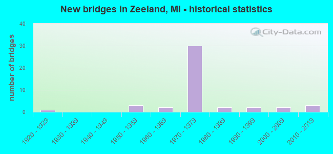
- New bridges - historical statistics
- 11920-1929
- 31950-1959
- 21960-1969
- 301970-1979
- 21980-1989
- 21990-1999
- 22000-2009
- 32010-2019


- Bridge Condition - Deck
- 16.7%Very good
- 36.7%Good
- 33.3%Satisfactory
- 6.7%Fair
- 3.3%Serious
- 3.3%Imminent failure

- Bridge Condition - Superstructure
- 20.0%Very good
- 33.3%Good
- 20.0%Satisfactory
- 13.3%Fair
- 6.7%Poor
- 3.3%Serious
- 3.3%Critical

- Bridge Condition - Substructure
- 6.7%Very good
- 46.7%Good
- 26.7%Satisfactory
- 13.3%Fair
- 6.7%Poor

- Bridge Condition - Channel
- 14.3%Very good
- 10.7%Good
- 39.3%Satisfactory
- 21.4%Fair
- 14.3%Poor

- Bridge Condition - Culverts
- 16.7%Very good
- 33.3%Good
- 33.3%Satisfactory
- 16.7%Fair
Find on map >> Show street view
Structure Number: 289, Location: JUST E OF 46TH ST (Lat: 42.768919, Lng: -85.999486), Route carried "on" structure: County highway , Year Built: 1969, Status: Open, Structure Length: 1.22m (4.00ft), Average Daily Traffic: 1,580 (year 2020), Truck Traffic: 7%, Average Future Daily Traffic: 2,350 (year 2040), Design Load: HS 20+Mod, Features Intersected: S BR MACATAWA RIVER, Facility Carried by Structure: OTTOGAN STREET
Minimum Vertical Clearance: 30.48m (100.00ft), Kilometerpoint: 16.393, Lanes on structure: 2, Owner: County Highway Agency, Approaching Roadway Width: 9.1m (29.9ft), Material/Design: Wood or Timber, Design/Construction: Slab, Number Of Spans In Main Unit: 2, Length of Maximum Span: 6.1m (20.0ft), Curb-To-Curb Width: 8.4m (27.6ft), Out-to-Out Width: 9.0m (29.5ft)
Condition: Deck: Satisfactory, Superstructure: Satisfactory, Substructure: Poor, Channel: Poor, Operating Rating: 52.5 metric tons, Method Used To Determine Operating Rating: Allowable Stress (AS) rating reported by rating factor (RF) method using MS18 loading, Inventory Rating: 39.5 metric tons, Method Used To Determine Inventory Rating: Allowable Stress (AS) rating reported by rating factor (RF) method using MS18 loading, Structural Evaluation: Meets minimum limits, Deck Geometry: Meets minimum limits, Waterway Adequacy: Equal to present desirable criteria, Approach Roadway Alignment: Equal to present desirable criteria, Designated Inspection Frequency: Every 12 months, Inspection Date: May 2021, Deck Structure Type: Wood or Timber, Wearing Surface/Protective System: Wearing Surface: Bituminous
Find on map >> Show street view
Structure Number: 29, Location: OVERISEL TWP SEC 6 (Lat: 42.757542, Lng: -86.009608), Route carried "on" structure: ServiceCounty highway , Year Built: 1926, Status: Closed, Structure Length: 0.97m (3.18ft), Average Daily Traffic: 36 (year 2002), Truck Traffic: 7%, Average Future Daily Traffic: 72 (year 2022), Design Load: H 15, Features Intersected: S BR MACATAWA RIVER, Facility Carried by Structure: 47TH STREET
Minimum Vertical Clearance: 30.48m (100.00ft), Kilometerpoint: 3.251, Lanes on structure: 2, Owner: County Highway Agency, Approaching Roadway Width: 4.3m (14.1ft), Material/Design: Steel, Design/Construction: Stringer/Multi-beam, Number Of Spans In Main Unit: 1, Length of Maximum Span: 9.1m (29.9ft), Curb-To-Curb Width: 4.3m (14.1ft), Out-to-Out Width: 4.3m (14.1ft)
Condition: Deck: Imminent failure, Superstructure: Poor, Substructure: Poor, Channel: Fair, Operating Rating: 22.6 metric tons, Method Used To Determine Operating Rating: Load Factor (LF), Inventory Rating: 9.0 metric tons, Method Used To Determine Inventory Rating: Load Factor (LF), Waterway Adequacy: Equal to present minimum criteria, Bridge Posting: Required (Relationship of Operating Rating to Maximum Legal Load: > 39.9% below), Length Of Structure Improvement: 1.52m (4.99ft), Designated Inspection Frequency: Every 24 months, Inspection Date: May 2021, Bridge Improvement Cost: $200,000, Roadway Improvement Cost: $53,000, Total Project Cost: $253,000, Deck Structure Type: Concrete Cast-file-Place, Wearing Surface/Protective System: Wearing Surface: Monolithic Concrete
Find on map >> Show street view
Structure Number: 292, Location: APPROX 1/4MI S OF 147THAV (Lat: 42.757475, Lng: -85.970006), Route carried "on" structure: County highway , Year Built: 1988, Status: Open, Structure Length: 0.78m (2.56ft), Average Daily Traffic: 548 (year 2002), Truck Traffic: 7%, Average Future Daily Traffic: 1,096 (year 2022), Design Load: H 20, Features Intersected: OVER A SMALL CREEK, Facility Carried by Structure: 43RD STREET
Minimum Vertical Clearance: 30.48m (100.00ft), Kilometerpoint: 7.672, Lanes on structure: 2, Owner: County Highway Agency, Approaching Roadway Width: 7.0m (23.0ft), Skew: 1 degrees, Material/Design: Steel, Design/Construction: Culvert, Number Of Spans In Main Unit: 2, Length of Maximum Span: 3.3m (10.8ft)
Condition: Channel: Poor, Culverts: Satisfactory, Operating Rating: 97.2 metric tons, Method Used To Determine Operating Rating: Load Factor (LF) rating reported by rating factor (RF) method using MS18 loading, Inventory Rating: 97.2 metric tons, Method Used To Determine Inventory Rating: Load Factor (LF) rating reported by rating factor (RF) method using MS18 loading, Structural Evaluation: Equal to present minimum criteria, Waterway Adequacy: Somewhat better than minimum adequacy, Approach Roadway Alignment: Equal to present desirable criteria, Designated Inspection Frequency: Every 24 months, Inspection Date: May 2021
Find on map >> Show street view
Structure Number: 293, Location: OVERISEL TWP SEC 4 (Lat: 42.768522, Lng: -85.970506), Route carried "on" structure: County highway , Year Built: 1992, Status: Open, Structure Length: 0.98m (3.22ft), Average Daily Traffic: 145 (year 2002), Truck Traffic: 7%, Average Future Daily Traffic: 290 (year 2022), Design Load: H 20, Features Intersected: UNNAMED CREEK, Facility Carried by Structure: 43RD STREET
Minimum Vertical Clearance: 30.48m (100.00ft), Kilometerpoint: 8.898, Lanes on structure: 2, Owner: County Highway Agency, Approaching Roadway Width: 8.5m (27.9ft), Skew: 2 degrees, Material/Design: Steel, Design/Construction: Culvert, Number Of Spans In Main Unit: 2, Length of Maximum Span: 4.2m (13.8ft)
Condition: Channel: Satisfactory, Culverts: Good, Operating Rating: 61.6 metric tons, Method Used To Determine Operating Rating: Load Factor (LF) rating reported by rating factor (RF) method using MS18 loading, Inventory Rating: 36.9 metric tons, Method Used To Determine Inventory Rating: Load Factor (LF) rating reported by rating factor (RF) method using MS18 loading, Structural Evaluation: Better than present minimum criteria, Waterway Adequacy: Equal to present minimum criteria, Approach Roadway Alignment: Equal to present desirable criteria, Designated Inspection Frequency: Every 24 months, Inspection Date: May 2021
Find on map >> Show street view
Structure Number: 294, Location: OVERSIEL TWP SEC 3-4 (Lat: 42.766408, Lng: -85.960458), Route carried "on" structure: County highway , Year Built: 1991, Status: Open, Structure Length: 0.87m (2.85ft), Average Daily Traffic: 31 (year 2002), Truck Traffic: 7%, Average Future Daily Traffic: 62 (year 2022), Design Load: H 20, Features Intersected: UNNAMED CREEK, Facility Carried by Structure: 42ND STREET
Minimum Vertical Clearance: 30.48m (100.00ft), Kilometerpoint: 0.599, Lanes on structure: 2, Owner: County Highway Agency, Approaching Roadway Width: 9.8m (32.2ft), Material/Design: Steel, Design/Construction: Culvert, Number Of Spans In Main Unit: 2, Length of Maximum Span: 3.7m (12.1ft)
Condition: Channel: Satisfactory, Culverts: Good, Operating Rating: 64.2 metric tons, Method Used To Determine Operating Rating: Load Factor (LF) rating reported by rating factor (RF) method using MS18 loading, Inventory Rating: 38.2 metric tons, Method Used To Determine Inventory Rating: Load Factor (LF) rating reported by rating factor (RF) method using MS18 loading, Structural Evaluation: Better than present minimum criteria, Waterway Adequacy: Equal to present minimum criteria, Approach Roadway Alignment: Equal to present desirable criteria, Designated Inspection Frequency: Every 24 months, Inspection Date: May 2021
Find on map >> Show street view
Structure Number: 8709, Location: 2.0 MI NE OF US-31 (Lat: 42.805064, Lng: -86.043617), Route carried "on" structure: Business Interstate 196, Year Built: 1955, Status: Open, Structure Length: 1.83m (6.00ft), Average Daily Traffic: 13,496 (year 2017), Truck Traffic: 7%, Average Future Daily Traffic: 15,520 (year 2037), Design Load: HS 20, Features Intersected: BR OF BLACK RIVER
Minimum Vertical Clearance: 30.48m (100.00ft), Kilometerpoint: 3.653, Lanes on structure: 2, Base Highway Network: Yes (Inventory Route: 370, Subroute: 31), Owner: State Highway Agency, Approaching Roadway Width: 12.8m (42.0ft), Skew: 3 degrees, Material/Design: Steel, Design/Construction: Stringer/Multi-beam, Number Of Spans In Main Unit: 1, Length of Maximum Span: 18.2m (59.7ft), Curb-To-Curb Width: 11.8m (38.7ft), Out-to-Out Width: 12.8m (42.0ft)
Condition: Deck: Good, Superstructure: Fair, Substructure: Satisfactory, Channel: Satisfactory, Operating Rating: 74.2 metric tons, Method Used To Determine Operating Rating: Load Factor (LF) rating reported by rating factor (RF) method using MS18 loading, Inventory Rating: 44.4 metric tons, Method Used To Determine Inventory Rating: Load Factor (LF) rating reported by rating factor (RF) method using MS18 loading, Structural Evaluation: Somewhat better than minimum adequacy, Deck Geometry: Better than present minimum criteria, Waterway Adequacy: Equal to present minimum criteria, Approach Roadway Alignment: Equal to present desirable criteria, Length Of Structure Improvement: 1.83m (6.00ft), Designated Inspection Frequency: Every 17 months, Inspection Date: November 2020, Bridge Improvement Cost: $32,000, Roadway Improvement Cost: $5,000, Total Project Cost: $54,000, Deck Structure Type: Concrete Cast-file-Place, Wearing Surface/Protective System: Wearing Surface: Latex Concrete, Deck Protection: Epoxy Coated Reinforcing
Find on map >> Show street view
Structure Number: 871, Location: 7.5 MI NE OF US-31 (Lat: 42.835083, Lng: -85.951044), Route carried "on" structure: State highway 121, Year Built: 1955, Year Reconstructed: 2010, Status: Open, Structure Length: 1.22m (4.00ft), Average Daily Traffic: 12,800 (year 2010), Truck Traffic: 10%, Average Future Daily Traffic: 17,200 (year 2030), Design Load: HS 25 or greater, Features Intersected: MACATAWA RIVER
Minimum Vertical Clearance: 30.48m (100.00ft), Kilometerpoint: 4.450, Lanes on structure: 2, Owner: State Highway Agency, Approaching Roadway Width: 12.8m (42.0ft), Skew: 1 degrees, Material/Design: Steel, Design/Construction: Stringer/Multi-beam, Number Of Spans In Main Unit: 1, Length of Maximum Span: 11.7m (38.4ft), Curb-To-Curb Width: 14.1m (46.3ft), Out-to-Out Width: 15.1m (49.5ft)
Condition: Deck: Good, Superstructure: Satisfactory, Substructure: Good, Channel: Good, Operating Rating: 75.6 metric tons, Method Used To Determine Operating Rating: Load Factor (LF), Inventory Rating: 45.3 metric tons, Method Used To Determine Inventory Rating: Load Factor (LF), Structural Evaluation: Equal to present minimum criteria, Deck Geometry: Superior to present desirable criteria, Waterway Adequacy: Equal to present desirable criteria, Approach Roadway Alignment: Better than present minimum criteria, Designated Inspection Frequency: Every 24 months, Inspection Date: April 2020, Deck Structure Type: Concrete Cast-file-Place, Wearing Surface/Protective System: Wearing Surface: Latex Concrete, Deck Protection: Epoxy Coated Reinforcing
Find on map >> Show street view
Structure Number: 8724, Location: 2 MI E OF ZEELAND (Lat: 42.816772, Lng: -85.969900), Route carried "on" structure: Interstate 196, Year Built: 1972, Status: Open, Structure Length: 5.48m (17.98ft), Average Daily Traffic: 15,999 (year 2007), Truck Traffic: 13%, Average Future Daily Traffic: 21,239 (year 2018), Design Load: HS 20, Features Intersected: BLACK RIVER
Minimum Vertical Clearance: 30.48m (100.00ft), Kilometerpoint: 8.113, Lanes on structure: 2, Base Highway Network: Yes (Inventory Route: 75, Subroute: 4), Owner: State Highway Agency, Approaching Roadway Width: 14.0m (45.9ft), Skew: 3 degrees, Material/Design: Steel, Design/Construction: Stringer/Multi-beam, Number Of Spans In Main Unit: 3, Length of Maximum Span: 21.3m (69.9ft), Curb-To-Curb Width: 12.8m (42.0ft), Out-to-Out Width: 13.3m (43.6ft)
Condition: Deck: Satisfactory, Superstructure: Good, Substructure: Satisfactory, Channel: Satisfactory, Operating Rating: 97.2 metric tons, Method Used To Determine Operating Rating: Load Factor (LF) rating reported by rating factor (RF) method using MS18 loading, Inventory Rating: 59.3 metric tons, Method Used To Determine Inventory Rating: Load Factor (LF) rating reported by rating factor (RF) method using MS18 loading, Structural Evaluation: Equal to present minimum criteria, Deck Geometry: Equal to present desirable criteria, Waterway Adequacy: Equal to present desirable criteria, Approach Roadway Alignment: Equal to present desirable criteria, Designated Inspection Frequency: Every 24 months, Inspection Date: May 2020, Deck Structure Type: Concrete Cast-file-Place, Wearing Surface/Protective System: Wearing Surface: Monolithic Concrete
Find on map >> Show street view
Structure Number: 8725, Location: 2 MI E OF ZEELAND (Lat: 42.817364, Lng: -85.969467), Route carried "on" structure: Interstate 196, Year Built: 1972, Status: Open, Structure Length: 5.48m (17.98ft), Average Daily Traffic: 15,999 (year 2007), Truck Traffic: 13%, Average Future Daily Traffic: 21,239 (year 2018), Design Load: HS 20, Features Intersected: BLACK RIVER
Minimum Vertical Clearance: 30.48m (100.00ft), Kilometerpoint: 8.237, Lanes on structure: 2, Base Highway Network: Yes (Inventory Route: 75, Subroute: 3), Owner: State Highway Agency, Approaching Roadway Width: 14.0m (45.9ft), Skew: 3 degrees, Material/Design: Steel, Design/Construction: Stringer/Multi-beam, Number Of Spans In Main Unit: 3, Length of Maximum Span: 21.3m (69.9ft), Curb-To-Curb Width: 12.8m (42.0ft), Out-to-Out Width: 13.3m (43.6ft)
Condition: Deck: Satisfactory, Superstructure: Fair, Substructure: Good, Channel: Very good, Operating Rating: 90.7 metric tons, Method Used To Determine Operating Rating: Load Factor (LF) rating reported by rating factor (RF) method using MS18 loading, Inventory Rating: 54.4 metric tons, Method Used To Determine Inventory Rating: Load Factor (LF) rating reported by rating factor (RF) method using MS18 loading, Structural Evaluation: Somewhat better than minimum adequacy, Deck Geometry: Equal to present desirable criteria, Waterway Adequacy: Equal to present desirable criteria, Approach Roadway Alignment: Equal to present desirable criteria, Designated Inspection Frequency: Every 24 months, Inspection Date: May 2020, Deck Structure Type: Concrete Cast-file-Place, Wearing Surface/Protective System: Wearing Surface: Monolithic Concrete
Find on map >> Show street view
Structure Number: 8732, Location: 1 MI E OF HOLLAND (Lat: 42.783422, Lng: -86.026808), Route carried "on" structure: County highway 7004, Year Built: 1972, Status: Open, Structure Length: 7.62m (25.00ft), Average Daily Traffic: 9,100 (year 1995), Truck Traffic: 1%, Average Future Daily Traffic: 1,850 (year 1977), Design Load: H 20, Features Intersected: I-196, Facility Carried by Structure: ADAMS RD
Minimum Vertical Clearance: 30.48m (100.00ft), Kilometerpoint: 8.578, Lanes on structure: 3, Lanes under structure: 5, Base Highway Network: Yes (Inventory Route: 75, Subroute: 2), Owner: State Highway Agency, Approaching Roadway Width: 17.0m (55.8ft), Skew: 1 degrees, Material/Design: Steel, Design/Construction: Stringer/Multi-beam, Number Of Spans In Main Unit: 2, Length of Maximum Span: 38.7m (127.0ft), Curb or Sidewalk Widths: Left: 0.2m (0.7ft), Right: 0.2m (0.7ft), Curb-To-Curb Width: 17.0m (55.8ft), Out-to-Out Width: 17.8m (58.4ft)
Condition: Deck: Good, Superstructure: Good, Substructure: Good, Operating Rating: 81.0 metric tons, Method Used To Determine Operating Rating: Load Factor (LF) rating reported by rating factor (RF) method using MS18 loading, Inventory Rating: 48.3 metric tons, Method Used To Determine Inventory Rating: Load Factor (LF) rating reported by rating factor (RF) method using MS18 loading, Structural Evaluation: Better than present minimum criteria, Deck Geometry: Superior to present desirable criteria, Underclear: Somewhat better than minimum adequacy, Approach Roadway Alignment: Equal to present desirable criteria, Length Of Structure Improvement: 7.62m (25.00ft), Designated Inspection Frequency: Every 24 months, Inspection Date: October 2020, Bridge Improvement Cost: $348,000, Roadway Improvement Cost: $21,000, Total Project Cost: $249,000, Deck Structure Type: Concrete Cast-file-Place, Wearing Surface/Protective System: Wearing Surface: Monolithic Concrete
Find on map >> Show street view
Structure Number: 8733, Location: 1.5 MI N OF ALLEGAN COL (Lat: 42.791825, Lng: -86.018511), Route carried "on" structure: Interstate 196, Year Built: 1972, Status: Open, Structure Length: 3.58m (11.75ft), Average Daily Traffic: 12,652 (year 2007), Truck Traffic: 17%, Average Future Daily Traffic: 16,849 (year 2018), Design Load: HS 20, Features Intersected: 96TH AVE
Minimum Vertical Clearance: 30.48m (100.00ft), Kilometerpoint: 2.977, Lanes on structure: 2, Lanes under structure: 2, Base Highway Network: Yes (Inventory Route: 75, Subroute: 4), Owner: State Highway Agency, Approaching Roadway Width: 12.2m (40.0ft), Skew: 3 degrees, Material/Design: Steel, Design/Construction: Stringer/Multi-beam, Number Of Spans In Main Unit: 1, Length of Maximum Span: 34.5m (113.2ft), Curb-To-Curb Width: 12.3m (40.4ft), Out-to-Out Width: 13.3m (43.6ft)
Condition: Deck: Satisfactory, Superstructure: Good, Substructure: Good, Operating Rating: 74.5 metric tons, Method Used To Determine Operating Rating: Load Factor (LF) rating reported by rating factor (RF) method using MS18 loading, Inventory Rating: 44.7 metric tons, Method Used To Determine Inventory Rating: Load Factor (LF) rating reported by rating factor (RF) method using MS18 loading, Structural Evaluation: Better than present minimum criteria, Deck Geometry: Better than present minimum criteria, Underclear: Meets minimum limits, Approach Roadway Alignment: Equal to present desirable criteria, Length Of Structure Improvement: 3.60m (11.81ft), Designated Inspection Frequency: Every 24 months, Inspection Date: April 2020, Bridge Improvement Cost: $96,000, Roadway Improvement Cost: $5,000, Total Project Cost: $59,000, Deck Structure Type: Concrete Cast-file-Place, Wearing Surface/Protective System: Wearing Surface: Epoxy Overlay
Find on map >> Show street view
Structure Number: 8734, Location: 2.9 MI NE OF ALLEGAN COL (Lat: 42.796875, Lng: -85.999831), Route carried "on" structure: County highway , Year Built: 1972, Status: Open, Structure Length: 7.86m (25.79ft), Average Daily Traffic: 1,600 (year 1996), Truck Traffic: 1%, Average Future Daily Traffic: 1,840 (year 2016), Design Load: H 20, Features Intersected: I-196, Facility Carried by Structure: 88TH AVE
Minimum Vertical Clearance: 30.48m (100.00ft), Kilometerpoint: 1.534, Lanes on structure: 2, Lanes under structure: 4, Owner: State Highway Agency, Approaching Roadway Width: 10.9m (35.8ft), Skew: 1 degrees, Material/Design: Steel, Design/Construction: Stringer/Multi-beam, Number Of Spans In Main Unit: 2, Length of Maximum Span: 39.3m (128.9ft), Curb or Sidewalk Widths: Left: 0.2m (0.7ft), Right: 0.2m (0.7ft), Curb-To-Curb Width: 10.9m (35.8ft), Out-to-Out Width: 11.7m (38.4ft)
Condition: Deck: Good, Superstructure: Good, Substructure: Good, Operating Rating: 85.5 metric tons, Method Used To Determine Operating Rating: Load Factor (LF) rating reported by rating factor (RF) method using MS18 loading, Inventory Rating: 51.2 metric tons, Method Used To Determine Inventory Rating: Load Factor (LF) rating reported by rating factor (RF) method using MS18 loading, Structural Evaluation: Better than present minimum criteria, Deck Geometry: Equal to present minimum criteria, Underclear: Somewhat better than minimum adequacy, Approach Roadway Alignment: Better than present minimum criteria, Length Of Structure Improvement: 7.87m (25.82ft), Designated Inspection Frequency: Every 24 months, Inspection Date: October 2020, Bridge Improvement Cost: $248,000, Roadway Improvement Cost: $15,000, Total Project Cost: $177,000, Deck Structure Type: Concrete Cast-file-Place, Wearing Surface/Protective System: Wearing Surface: Monolithic Concrete
Find on map >> Show street view
Structure Number: 8735, Location: E LTS OF ZEELAND (Lat: 42.812250, Lng: -85.980872), Route carried "on" structure: Interstate 196, Year Built: 1972, Status: Open, Structure Length: 5.42m (17.78ft), Average Daily Traffic: 12,652 (year 2007), Truck Traffic: 17%, Average Future Daily Traffic: 16,849 (year 2018), Design Load: HS 20, Features Intersected: I-196 BL(BYRON ROAD)
Minimum Vertical Clearance: 30.48m (100.00ft), Kilometerpoint: 7.033, Lanes on structure: 3, Lanes under structure: 5, Base Highway Network: Yes (Inventory Route: 75, Subroute: 4), Owner: State Highway Agency, Approaching Roadway Width: 12.8m (42.0ft), Skew: 3 degrees, Material/Design: Steel, Design/Construction: Stringer/Multi-beam, Number Of Spans In Main Unit: 2, Length of Maximum Span: 28.6m (93.8ft), Curb-To-Curb Width: 15.2m (49.9ft), Out-to-Out Width: 15.7m (51.5ft)
Condition: Deck: Satisfactory, Superstructure: Satisfactory, Substructure: Satisfactory, Operating Rating: 89.7 metric tons, Method Used To Determine Operating Rating: Load Factor (LF) rating reported by rating factor (RF) method using MS18 loading, Inventory Rating: 53.8 metric tons, Method Used To Determine Inventory Rating: Load Factor (LF) rating reported by rating factor (RF) method using MS18 loading, Structural Evaluation: Equal to present minimum criteria, Deck Geometry: Meets minimum limits, Underclear: Meets minimum limits, Approach Roadway Alignment: Equal to present desirable criteria, Designated Inspection Frequency: Every 24 months, Inspection Date: May 2020, Deck Structure Type: Concrete Cast-file-Place, Wearing Surface/Protective System: Wearing Surface: Monolithic Concrete
Find on map >> Show street view
Structure Number: 8736, Location: 3 MI E OF ZEELAND (Lat: 42.820647, Lng: -85.940022), Route carried "on" structure: Interstate 196, Year Built: 1972, Status: Open, Structure Length: 2.92m (9.58ft), Average Daily Traffic: 15,999 (year 2007), Truck Traffic: 13%, Average Future Daily Traffic: 21,239 (year 2018), Design Load: HS 20, Features Intersected: 64TH AVE
Minimum Vertical Clearance: 30.48m (100.00ft), Kilometerpoint: 10.601, Lanes on structure: 2, Lanes under structure: 2, Base Highway Network: Yes (Inventory Route: 75, Subroute: 4), Owner: State Highway Agency, Approaching Roadway Width: 12.8m (42.0ft), Skew: 1 degrees, Material/Design: Steel, Design/Construction: Stringer/Multi-beam, Number Of Spans In Main Unit: 1, Length of Maximum Span: 29.2m (95.8ft), Curb-To-Curb Width: 12.8m (42.0ft), Out-to-Out Width: 13.2m (43.3ft)
Condition: Deck: Good, Superstructure: Poor, Substructure: Good, Operating Rating: 97.2 metric tons, Method Used To Determine Operating Rating: Load Factor (LF) rating reported by rating factor (RF) method using MS18 loading, Inventory Rating: 69.3 metric tons, Method Used To Determine Inventory Rating: Load Factor (LF) rating reported by rating factor (RF) method using MS18 loading, Structural Evaluation: Meets minimum limits, Deck Geometry: Equal to present desirable criteria, Underclear: Meets minimum limits, Approach Roadway Alignment: Equal to present desirable criteria, Length Of Structure Improvement: 2.93m (9.61ft), Designated Inspection Frequency: Every 12 months, Inspection Date: May 2021, Bridge Improvement Cost: $70,000, Roadway Improvement Cost: $4,000, Total Project Cost: $45,000, Deck Structure Type: Concrete Cast-file-Place, Wearing Surface/Protective System: Wearing Surface: Monolithic Concrete
Find on map >> Show street view
Structure Number: 8737, Location: 3 MI E OF ZEELAND (Lat: 42.821247, Lng: -85.940033), Route carried "on" structure: Interstate 196, Year Built: 1972, Status: Open, Structure Length: 2.92m (9.58ft), Average Daily Traffic: 15,999 (year 2007), Truck Traffic: 13%, Average Future Daily Traffic: 21,239 (year 2018), Design Load: HS 20, Features Intersected: 64TH AVE
Minimum Vertical Clearance: 30.48m (100.00ft), Kilometerpoint: 10.688, Lanes on structure: 2, Lanes under structure: 2, Base Highway Network: Yes (Inventory Route: 75, Subroute: 3), Owner: State Highway Agency, Approaching Roadway Width: 12.8m (42.0ft), Skew: 1 degrees, Material/Design: Steel, Design/Construction: Stringer/Multi-beam, Number Of Spans In Main Unit: 1, Length of Maximum Span: 29.2m (95.8ft), Curb-To-Curb Width: 12.8m (42.0ft), Out-to-Out Width: 13.2m (43.3ft)
Condition: Deck: Satisfactory, Superstructure: Good, Substructure: Satisfactory, Operating Rating: 97.2 metric tons, Method Used To Determine Operating Rating: Load Factor (LF) rating reported by rating factor (RF) method using MS18 loading, Inventory Rating: 67.4 metric tons, Method Used To Determine Inventory Rating: Load Factor (LF) rating reported by rating factor (RF) method using MS18 loading, Structural Evaluation: Equal to present minimum criteria, Deck Geometry: Equal to present desirable criteria, Underclear: Somewhat better than minimum adequacy, Approach Roadway Alignment: Equal to present desirable criteria, Length Of Structure Improvement: 2.93m (9.61ft), Designated Inspection Frequency: Every 24 months, Inspection Date: May 2020, Bridge Improvement Cost: $72,000, Roadway Improvement Cost: $4,000, Total Project Cost: $46,000, Deck Structure Type: Concrete Cast-file-Place, Wearing Surface/Protective System: Wearing Surface: Monolithic Concrete
Find on map >> Show street view
Structure Number: 8745, Location: 1.5 MI N OF ALLEGAN COL (Lat: 42.792175, Lng: -86.018525), Route carried "on" structure: Interstate 196, Year Built: 1972, Status: Open, Structure Length: 3.58m (11.75ft), Average Daily Traffic: 12,652 (year 2007), Truck Traffic: 17%, Average Future Daily Traffic: 16,849 (year 2018), Design Load: HS 20+Mod, Features Intersected: 96TH AVE
Minimum Vertical Clearance: 30.48m (100.00ft), Kilometerpoint: 3.063, Lanes on structure: 2, Lanes under structure: 2, Base Highway Network: Yes (Inventory Route: 75, Subroute: 3), Owner: State Highway Agency, Approaching Roadway Width: 12.2m (40.0ft), Material/Design: Steel, Design/Construction: Stringer/Multi-beam, Number Of Spans In Main Unit: 1, Length of Maximum Span: 34.5m (113.2ft), Curb-To-Curb Width: 12.3m (40.4ft), Out-to-Out Width: 13.3m (43.6ft)
Condition: Deck: Satisfactory, Superstructure: Good, Substructure: Good, Operating Rating: 97.2 metric tons, Method Used To Determine Operating Rating: Load Factor (LF) rating reported by rating factor (RF) method using MS18 loading, Inventory Rating: 65.4 metric tons, Method Used To Determine Inventory Rating: Load Factor (LF) rating reported by rating factor (RF) method using MS18 loading, Structural Evaluation: Better than present minimum criteria, Deck Geometry: Better than present minimum criteria, Underclear: Meets minimum limits, Approach Roadway Alignment: Equal to present desirable criteria, Length Of Structure Improvement: 3.60m (11.81ft), Designated Inspection Frequency: Every 24 months, Inspection Date: May 2020, Bridge Improvement Cost: $96,000, Roadway Improvement Cost: $5,000, Total Project Cost: $59,000, Deck Structure Type: Concrete Cast-file-Place, Wearing Surface/Protective System: Wearing Surface: Epoxy Overlay
Find on map >> Show street view
Structure Number: 8746, Location: E LIMITS OF ZEELAND (Lat: 42.812242, Lng: -85.981428), Route carried "on" structure: Interstate 196, Year Built: 1972, Status: Open, Structure Length: 5.21m (17.09ft), Average Daily Traffic: 12,652 (year 2007), Truck Traffic: 17%, Average Future Daily Traffic: 16,849 (year 2018), Design Load: HS 20, Features Intersected: I-196BL (BYRON RD)
Minimum Vertical Clearance: 30.48m (100.00ft), Kilometerpoint: 7.041, Lanes on structure: 2, Lanes under structure: 5, Base Highway Network: Yes (Inventory Route: 75, Subroute: 3), Owner: State Highway Agency, Approaching Roadway Width: 12.2m (40.0ft), Skew: 3 degrees, Material/Design: Steel, Design/Construction: Stringer/Multi-beam, Number Of Spans In Main Unit: 2, Length of Maximum Span: 27.7m (90.9ft), Curb-To-Curb Width: 12.8m (42.0ft), Out-to-Out Width: 13.3m (43.6ft)
Condition: Deck: Satisfactory, Superstructure: Satisfactory, Substructure: Good, Operating Rating: 89.1 metric tons, Method Used To Determine Operating Rating: Load Factor (LF) rating reported by rating factor (RF) method using MS18 loading, Inventory Rating: 53.5 metric tons, Method Used To Determine Inventory Rating: Load Factor (LF) rating reported by rating factor (RF) method using MS18 loading, Structural Evaluation: Equal to present minimum criteria, Deck Geometry: Equal to present desirable criteria, Underclear: Meets minimum limits, Approach Roadway Alignment: Equal to present desirable criteria, Designated Inspection Frequency: Every 24 months, Inspection Date: May 2020, Deck Structure Type: Concrete Cast-file-Place, Wearing Surface/Protective System: Wearing Surface: Monolithic Concrete
Find on map >> Show street view
Structure Number: 8806, Location: 0.87 MILES E OF 96TH AVE (Lat: 42.783403, Lng: -86.000492), Route carried "on" structure: County highway 7004, Year Built: 2003, Status: Open, Structure Length: 2.80m (9.19ft), Average Daily Traffic: 8,270 (year 2020), Truck Traffic: 5%, Average Future Daily Traffic: 14,940 (year 2040), Design Load: HS 25 or greater, Features Intersected: BLACK RIVER, Facility Carried by Structure: ADAMS STREET
Minimum Vertical Clearance: 30.48m (100.00ft), Kilometerpoint: 10.730, Lanes on structure: 2, Owner: County Highway Agency, Approaching Roadway Width: 12.2m (40.0ft), Skew: 4 degrees, Material/Design: Prestressed concrete, Design/Construction: Box Beam or Girders - Single/Spread, Number Of Spans In Main Unit: 1, Length of Maximum Span: 27.4m (89.9ft), Curb or Sidewalk Widths: Left: 2.4m (7.9ft), Right: 0.0m, Curb-To-Curb Width: 12.2m (40.0ft), Out-to-Out Width: 16.0m (52.5ft)
Condition: Deck: Good, Superstructure: Very good, Substructure: Good, Channel: Very good, Operating Rating: 97.2 metric tons, Method Used To Determine Operating Rating: Load Factor (LF) rating reported by rating factor (RF) method using MS18 loading, Inventory Rating: 59.3 metric tons, Method Used To Determine Inventory Rating: Load Factor (LF) rating reported by rating factor (RF) method using MS18 loading, Structural Evaluation: Better than present minimum criteria, Deck Geometry: Somewhat better than minimum adequacy, Waterway Adequacy: Equal to present desirable criteria, Approach Roadway Alignment: Equal to present desirable criteria, Designated Inspection Frequency: Every 24 months, Inspection Date: December 2020, Deck Structure Type: Concrete Cast-file-Place, Wearing Surface/Protective System: Wearing Surface: Monolithic Concrete, Deck Protection: Epoxy Coated Reinforcing
Find on map >> Show street view
Structure Number: 8807, Location: 0.1 MI W OF 80TH AVE (Lat: 42.783336, Lng: -85.981964), Route carried "on" structure: County highway 7004, Year Built: 1973, Status: Open, Structure Length: 0.91m (2.99ft), Average Daily Traffic: 6,930 (year 2020), Truck Traffic: 5%, Average Future Daily Traffic: 12,510 (year 2040), Design Load: HS 20, Features Intersected: BLACK RIVER TRIBUTARY, Facility Carried by Structure: ADAMS ST
Minimum Vertical Clearance: 30.48m (100.00ft), Kilometerpoint: 12.246, Lanes on structure: 2, Owner: County Highway Agency, Approaching Roadway Width: 12.2m (40.0ft), Material/Design: Prestressed concrete, Design/Construction: Box Beam or Girders - Multiple, Number Of Spans In Main Unit: 1, Length of Maximum Span: 8.2m (26.9ft), Curb-To-Curb Width: 12.8m (42.0ft), Out-to-Out Width: 12.9m (42.3ft)
Condition: Deck: Very good, Superstructure: Very good, Substructure: Fair, Channel: Fair, Operating Rating: 72.9 metric tons, Method Used To Determine Operating Rating: Load Factor (LF) rating reported by rating factor (RF) method using MS18 loading, Inventory Rating: 43.4 metric tons, Method Used To Determine Inventory Rating: Load Factor (LF) rating reported by rating factor (RF) method using MS18 loading, Structural Evaluation: Somewhat better than minimum adequacy, Deck Geometry: Somewhat better than minimum adequacy, Waterway Adequacy: Equal to present desirable criteria, Approach Roadway Alignment: Equal to present desirable criteria, Designated Inspection Frequency: Every 24 months, Inspection Date: December 2020, Deck Structure Type: Concrete Precast Panels, Wearing Surface/Protective System: Wearing Surface: Bituminous, Membrane: Preformed Fabric
Find on map >> Show street view
Structure Number: 8808, Location: 0.59 MILES W OF 64TH AVE (Lat: 42.783083, Lng: -85.952142), Route carried "on" structure: County highway 7004, Year Built: 1973, Status: Open, Structure Length: 1.04m (3.41ft), Average Daily Traffic: 6,930 (year 2020), Truck Traffic: 5%, Average Future Daily Traffic: 12,510 (year 2040), Design Load: HS 20, Features Intersected: BLACK RIVER TRIBUTARY, Facility Carried by Structure: ADAMS STREET
Minimum Vertical Clearance: 30.48m (100.00ft), Kilometerpoint: 14.686, Lanes on structure: 2, Owner: County Highway Agency, Approaching Roadway Width: 12.2m (40.0ft), Skew: 4 degrees, Material/Design: Prestressed concrete, Design/Construction: Box Beam or Girders - Multiple, Number Of Spans In Main Unit: 1, Length of Maximum Span: 9.1m (29.9ft), Curb-To-Curb Width: 12.8m (42.0ft), Out-to-Out Width: 12.9m (42.3ft)
Condition: Deck: Fair, Superstructure: Fair, Substructure: Satisfactory, Channel: Fair, Operating Rating: 63.2 metric tons, Method Used To Determine Operating Rating: Load Factor (LF) rating reported by rating factor (RF) method using MS18 loading, Inventory Rating: 37.9 metric tons, Method Used To Determine Inventory Rating: Load Factor (LF) rating reported by rating factor (RF) method using MS18 loading, Structural Evaluation: Somewhat better than minimum adequacy, Deck Geometry: Somewhat better than minimum adequacy, Waterway Adequacy: Equal to present desirable criteria, Approach Roadway Alignment: Equal to present desirable criteria, Designated Inspection Frequency: Every 24 months, Inspection Date: December 2020, Deck Structure Type: Concrete Precast Panels, Wearing Surface/Protective System: Wearing Surface: Bituminous, Membrane: Preformed Fabric
Find on map >> Show street view
Structure Number: 881, Location: 0.83 MILES E OF 84TH AVE (Lat: 42.812192, Lng: -85.973283), Route carried "on" structure: County highway 7010, Year Built: 1980, Status: Posted for load, Structure Length: 2.43m (7.97ft), Average Daily Traffic: 8,610 (year 2019), Truck Traffic: 5%, Average Future Daily Traffic: 15,550 (year 2039), Design Load: HS 20, Features Intersected: BLACK RIVER, Facility Carried by Structure: BYRON ROAD
Minimum Vertical Clearance: 30.48m (100.00ft), Kilometerpoint: 12.465, Lanes on structure: 2, Base Highway Network: Yes (Inventory Route: 74, Subroute: 3), Owner: County Highway Agency, Approaching Roadway Width: 12.2m (40.0ft), Skew: 2 degrees, Material/Design: Prestressed concrete, Design/Construction: Box Beam or Girders - Multiple, Number Of Spans In Main Unit: 2, Length of Maximum Span: 12.2m (40.0ft), Curb-To-Curb Width: 13.1m (43.0ft), Out-to-Out Width: 13.2m (43.3ft)
Condition: Deck: Serious, Superstructure: Serious, Substructure: Satisfactory, Channel: Satisfactory, Operating Rating: 23.3 metric tons, Method Used To Determine Operating Rating: Load Factor (LF) rating reported by rating factor (RF) method using MS18 loading, Inventory Rating: 13.9 metric tons, Method Used To Determine Inventory Rating: Load Factor (LF) rating reported by rating factor (RF) method using MS18 loading, Structural Evaluation: High priority of corrective action, Deck Geometry: Somewhat better than minimum adequacy, Waterway Adequacy: Equal to present desirable criteria, Approach Roadway Alignment: Equal to present minimum criteria, Bridge Posting: Required (Relationship of Operating Rating to Maximum Legal Load: > 39.9% below), Designated Inspection Frequency: Every 12 months, Inspection Date: November 2021, Deck Structure Type: Concrete Precast Panels, Wearing Surface/Protective System: Wearing Surface: Bituminous, Membrane: Preformed Fabric
Find on map >> Show street view
Structure Number: 8812, Location: 0.70 MILES N OF OTTOGAN (Lat: 42.778742, Lng: -86.018281), Route carried "on" structure: County highway 7047, Year Built: 1955, Status: Posted for load, Structure Length: 2.34m (7.68ft), Average Daily Traffic: 9,570 (year 2019), Truck Traffic: 5%, Average Future Daily Traffic: 17,300 (year 2039), Design Load: HS 15, Features Intersected: BLACK RIVER TRIBUTARY, Facility Carried by Structure: 96TH AVE
Minimum Vertical Clearance: 30.48m (100.00ft), Kilometerpoint: 1.091, Lanes on structure: 2, Owner: County Highway Agency, Approaching Roadway Width: 11.0m (36.1ft), Material/Design: Steel, Design/Construction: Stringer/Multi-beam, Number Of Spans In Main Unit: 2, Length of Maximum Span: 11.5m (37.7ft), Curb-To-Curb Width: 7.3m (24.0ft), Out-to-Out Width: 7.3m (24.0ft)
Condition: Deck: Fair, Superstructure: Critical, Substructure: Fair, Channel: Fair, Operating Rating: 12.0 metric tons, Method Used To Determine Operating Rating: Load Factor (LF) rating reported by rating factor (RF) method using MS18 loading, Inventory Rating: 7.1 metric tons, Method Used To Determine Inventory Rating: Load Factor (LF) rating reported by rating factor (RF) method using MS18 loading, Structural Evaluation: High priority of replacement, Deck Geometry: High priority of replacement, Waterway Adequacy: Equal to present desirable criteria, Approach Roadway Alignment: Equal to present desirable criteria, Bridge Posting: Required (Relationship of Operating Rating to Maximum Legal Load: > 39.9% below), Designated Inspection Frequency: Every 12 months, Inspection Date: November 2021, Deck Structure Type: Concrete Cast-file-Place, Wearing Surface/Protective System: Wearing Surface: Bituminous
Find on map >> Show street view
Structure Number: 8886, Location: SECTION 14 HOLLAND TWP (Lat: 42.826814, Lng: -86.049036), Route carried "on" structure: County highway , Year Built: 2011, Status: Open, Structure Length: 1.83m (6.00ft), Average Daily Traffic: 13,450 (year 2019), Truck Traffic: 7%, Average Future Daily Traffic: 24,300 (year 2039), Design Load: Greater than HL93, Features Intersected: BLACK CREEK, Facility Carried by Structure: RILEY ST
Minimum Vertical Clearance: 30.48m (100.00ft), Kilometerpoint: 13.234, Lanes on structure: 2, Owner: County Highway Agency, Approaching Roadway Width: 11.0m (36.1ft), Material/Design: Prestressed concrete, Design/Construction: Box Beam or Girders - Multiple, Number Of Spans In Main Unit: 1, Length of Maximum Span: 17.9m (58.7ft), Curb-To-Curb Width: 12.3m (40.4ft), Out-to-Out Width: 18.1m (59.4ft)
Condition: Deck: Very good, Superstructure: Very good, Substructure: Very good, Channel: Very good, Operating Rating: 73.9 metric tons, Method Used To Determine Operating Rating: Load and Resistance Factor Rating (LRFR) rating reported by rating factor(RF) method using HL-93 loadings, Inventory Rating: 57.0 metric tons, Method Used To Determine Inventory Rating: Load and Resistance Factor Rating (LRFR) rating reported by rating factor(RF) method using HL-93 loadings, Structural Evaluation: Equal to present desirable criteria, Deck Geometry: Somewhat better than minimum adequacy, Waterway Adequacy: Equal to present desirable criteria, Approach Roadway Alignment: Equal to present desirable criteria, Designated Inspection Frequency: Every 24 months, Inspection Date: November 2020, Deck Structure Type: Concrete Cast-file-Place, Wearing Surface/Protective System: Wearing Surface: Monolithic Concrete, Deck Protection: Epoxy Coated Reinforcing
Find on map >> Show street view
Structure Number: 8888, Location: SECTION 11 HOLLAND TWP (Lat: 42.841347, Lng: -86.047764), Route carried "on" structure: County highway , Year Built: 1968, Status: Open, Structure Length: 1.03m (3.38ft), Average Daily Traffic: 7,464 (year 2019), Truck Traffic: 5%, Average Future Daily Traffic: 13,480 (year 2039), Design Load: H 20, Features Intersected: BLACK CREEK, Facility Carried by Structure: QUINCY STREET
Minimum Vertical Clearance: 30.48m (100.00ft), Kilometerpoint: 13.086, Lanes on structure: 2, Owner: County Highway Agency, Approaching Roadway Width: 11.0m (36.1ft), Material/Design: Prestressed concrete, Design/Construction: Box Beam or Girders - Multiple, Number Of Spans In Main Unit: 1, Length of Maximum Span: 9.7m (31.8ft), Curb-To-Curb Width: 10.7m (35.1ft), Out-to-Out Width: 11.0m (36.1ft)
Condition: Deck: Good, Superstructure: Good, Substructure: Good, Channel: Good, Operating Rating: 39.9 metric tons, Method Used To Determine Operating Rating: Load and Resistance Factor Rating (LRFR) rating reported by rating factor(RF) method using HL-93 loadings, Inventory Rating: 28.2 metric tons, Method Used To Determine Inventory Rating: Load and Resistance Factor Rating (LRFR) rating reported by rating factor(RF) method using HL-93 loadings, Structural Evaluation: Better than present minimum criteria, Deck Geometry: Meets minimum limits, Waterway Adequacy: Equal to present desirable criteria, Approach Roadway Alignment: Better than present minimum criteria, Designated Inspection Frequency: Every 24 months, Inspection Date: November 2020, Deck Structure Type: Concrete Precast Panels, Wearing Surface/Protective System: Wearing Surface: Bituminous, Membrane: Preformed Fabric
Find on map >> Show street view
Structure Number: 8892, Location: SECTION 11 HOLLAND TWP (Lat: 42.828942, Lng: -86.039808), Route carried "on" structure: County highway , Year Built: 2008, Status: Open, Structure Length: 1.55m (5.09ft), Average Daily Traffic: 4,080 (year 2019), Truck Traffic: 5%, Average Future Daily Traffic: 7,370 (year 2039), Design Load: HL 93, Features Intersected: BLACK CREEK, Facility Carried by Structure: 104TH AVE
Minimum Vertical Clearance: 30.48m (100.00ft), Kilometerpoint: 1.928, Lanes on structure: 2, Owner: County Highway Agency, Approaching Roadway Width: 12.2m (40.0ft), Material/Design: Prestressed concrete, Design/Construction: Box Beam or Girders - Single/Spread, Number Of Spans In Main Unit: 1, Length of Maximum Span: 14.3m (46.9ft), Curb-To-Curb Width: 12.2m (40.0ft), Out-to-Out Width: 15.8m (51.8ft)
Condition: Deck: Good, Superstructure: Very good, Substructure: Very good, Channel: Satisfactory, Operating Rating: 82.9 metric tons, Method Used To Determine Operating Rating: Load and Resistance Factor Rating (LRFR) rating reported by rating factor(RF) method using HL-93 loadings, Inventory Rating: 64.2 metric tons, Method Used To Determine Inventory Rating: Load and Resistance Factor Rating (LRFR) rating reported by rating factor(RF) method using HL-93 loadings, Structural Evaluation: Equal to present desirable criteria, Deck Geometry: Equal to present minimum criteria, Waterway Adequacy: Equal to present desirable criteria, Approach Roadway Alignment: Better than present minimum criteria, Designated Inspection Frequency: Every 24 months, Inspection Date: November 2020, Deck Structure Type: Concrete Cast-file-Place, Wearing Surface/Protective System: Wearing Surface: Monolithic Concrete, Deck Protection: Epoxy Coated Reinforcing
Find on map >> Show street view
Structure Number: 8927, Location: SECTION 16 ZEELAND TWP (Lat: 42.819414, Lng: -85.967922), Route carried "on" structure: County highway , Year Built: 1973, Status: Open, Structure Length: 2.31m (7.58ft), Average Daily Traffic: 100 (year 2020), Truck Traffic: 5%, Average Future Daily Traffic: 180 (year 2040), Design Load: H 20, Features Intersected: BLACK RIVER, Facility Carried by Structure: FELCH STREET
Minimum Vertical Clearance: 30.48m (100.00ft), Kilometerpoint: 1.782, Lanes on structure: 2, Owner: County Highway Agency, Approaching Roadway Width: 7.9m (25.9ft), Skew: 3 degrees, Material/Design: Prestressed concrete, Design/Construction: Box Beam or Girders - Multiple, Number Of Spans In Main Unit: 2, Length of Maximum Span: 11.2m (36.7ft), Curb-To-Curb Width: 11.0m (36.1ft), Out-to-Out Width: 11.1m (36.4ft)
Condition: Deck: Good, Superstructure: Good, Substructure: Fair, Channel: Fair, Operating Rating: 53.1 metric tons, Method Used To Determine Operating Rating: Load Factor (LF) rating reported by rating factor (RF) method using MS18 loading, Inventory Rating: 31.8 metric tons, Method Used To Determine Inventory Rating: Load Factor (LF) rating reported by rating factor (RF) method using MS18 loading, Structural Evaluation: Somewhat better than minimum adequacy, Deck Geometry: Superior to present desirable criteria, Waterway Adequacy: Equal to present desirable criteria, Approach Roadway Alignment: Meets minimum limits, Designated Inspection Frequency: Every 24 months, Inspection Date: November 2020, Deck Structure Type: Concrete Precast Panels, Wearing Surface/Protective System: Wearing Surface: Bituminous, Membrane: Preformed Fabric
Find on map >> Show street view
Structure Number: 8928, Location: SECTION 16 ZEELAND TWP (Lat: 42.826661, Lng: -85.962483), Route carried "on" structure: County highway , Year Built: 1976, Status: Open, Structure Length: 1.67m (5.48ft), Average Daily Traffic: 910 (year 2020), Truck Traffic: 5%, Average Future Daily Traffic: 1,640 (year 2040), Design Load: H 20, Features Intersected: BLACK RIVER, Facility Carried by Structure: RILEY STREET
Minimum Vertical Clearance: 30.48m (100.00ft), Kilometerpoint: 1.173, Lanes on structure: 2, Owner: County Highway Agency, Approaching Roadway Width: 6.7m (22.0ft), Skew: 3 degrees, Material/Design: Prestressed concrete, Design/Construction: Box Beam or Girders - Multiple, Number Of Spans In Main Unit: 1, Length of Maximum Span: 16.1m (52.8ft), Curb-To-Curb Width: 11.0m (36.1ft), Out-to-Out Width: 11.1m (36.4ft)
Condition: Deck: Very good, Superstructure: Very good, Substructure: Good, Channel: Satisfactory, Operating Rating: 43.7 metric tons, Method Used To Determine Operating Rating: Load and Resistance Factor Rating (LRFR) rating reported by rating factor(RF) method using HL-93 loadings, Inventory Rating: 33.7 metric tons, Method Used To Determine Inventory Rating: Load and Resistance Factor Rating (LRFR) rating reported by rating factor(RF) method using HL-93 loadings, Structural Evaluation: Better than present minimum criteria, Deck Geometry: Better than present minimum criteria, Waterway Adequacy: Equal to present desirable criteria, Approach Roadway Alignment: Equal to present minimum criteria, Designated Inspection Frequency: Every 24 months, Inspection Date: December 2020, Deck Structure Type: Concrete Precast Panels, Wearing Surface/Protective System: Wearing Surface: Bituminous, Membrane: Preformed Fabric
Find on map >> Show street view
Structure Number: 8929, Location: SECTION 10 ZEELAND TWP (Lat: 42.840808, Lng: -85.942367), Route carried "on" structure: County highway , Year Built: 1974, Status: Open, Structure Length: 1.52m (4.99ft), Average Daily Traffic: 100 (year 2020), Truck Traffic: 5%, Average Future Daily Traffic: 180 (year 2040), Design Load: H 20, Features Intersected: BLACK RIVER, Facility Carried by Structure: QUINCY STREET
Minimum Vertical Clearance: 30.48m (100.00ft), Kilometerpoint: 6.331, Lanes on structure: 2, Owner: County Highway Agency, Approaching Roadway Width: 6.1m (20.0ft), Skew: 3 degrees, Material/Design: Prestressed concrete, Design/Construction: Box Beam or Girders - Multiple, Number Of Spans In Main Unit: 1, Length of Maximum Span: 14.6m (47.9ft), Curb-To-Curb Width: 11.0m (36.1ft), Out-to-Out Width: 11.2m (36.7ft)
Condition: Deck: Very good, Superstructure: Very good, Substructure: Satisfactory, Channel: Fair, Operating Rating: 44.4 metric tons, Method Used To Determine Operating Rating: Load and Resistance Factor Rating (LRFR) rating reported by rating factor(RF) method using HL-93 loadings, Inventory Rating: 32.7 metric tons, Method Used To Determine Inventory Rating: Load and Resistance Factor Rating (LRFR) rating reported by rating factor(RF) method using HL-93 loadings, Structural Evaluation: Equal to present minimum criteria, Deck Geometry: Superior to present desirable criteria, Waterway Adequacy: Equal to present desirable criteria, Approach Roadway Alignment: Equal to present minimum criteria, Designated Inspection Frequency: Every 24 months, Inspection Date: December 2020, Deck Structure Type: Concrete Precast Panels, Wearing Surface/Protective System: Wearing Surface: Bituminous, Membrane: Preformed Fabric
Find on map >> Show street view
Structure Number: 893, Location: SECTION 32 ZEELAND TWP (Lat: 42.777483, Lng: -85.990178), Route carried "on" structure: County highway , Year Built: 1974, Status: Open, Structure Length: 0.91m (2.99ft), Average Daily Traffic: 350 (year 2020), Truck Traffic: 5%, Average Future Daily Traffic: 630 (year 2040), Design Load: H 20, Features Intersected: S BRANCH OF BLACK RIVER, Facility Carried by Structure: 84TH AVE
Minimum Vertical Clearance: 30.48m (100.00ft), Kilometerpoint: 0.951, Lanes on structure: 2, Owner: County Highway Agency, Approaching Roadway Width: 11.0m (36.1ft), Material/Design: Prestressed concrete, Design/Construction: Box Beam or Girders - Multiple, Number Of Spans In Main Unit: 1, Length of Maximum Span: 8.8m (28.9ft), Curb-To-Curb Width: 11.0m (36.1ft), Out-to-Out Width: 11.1m (36.4ft)
Condition: Deck: Good, Superstructure: Good, Substructure: Satisfactory, Channel: Satisfactory, Operating Rating: 73.9 metric tons, Method Used To Determine Operating Rating: Load Factor (LF) rating reported by rating factor (RF) method using MS18 loading, Inventory Rating: 44.4 metric tons, Method Used To Determine Inventory Rating: Load Factor (LF) rating reported by rating factor (RF) method using MS18 loading, Structural Evaluation: Equal to present minimum criteria, Deck Geometry: Equal to present desirable criteria, Waterway Adequacy: Equal to present desirable criteria, Approach Roadway Alignment: Equal to present minimum criteria, Designated Inspection Frequency: Every 24 months, Inspection Date: December 2020, Deck Structure Type: Concrete Precast Panels, Wearing Surface/Protective System: Wearing Surface: Bituminous, Membrane: Preformed Fabric
Find on map >> Show street view
Structure Number: 8931, Location: SECTION 29 ZEELAND TWP (Lat: 42.790822, Lng: -85.990078), Route carried "on" structure: County highway , Year Built: 1976, Status: Open, Structure Length: 1.82m (5.97ft), Average Daily Traffic: 100 (year 2020), Truck Traffic: 5%, Average Future Daily Traffic: 180 (year 2040), Design Load: H 20, Features Intersected: BLACK RIVER, Facility Carried by Structure: 84TH AVE
Minimum Vertical Clearance: 30.48m (100.00ft), Kilometerpoint: 2.432, Lanes on structure: 2, Owner: County Highway Agency, Approaching Roadway Width: 6.7m (22.0ft), Material/Design: Prestressed concrete, Design/Construction: Box Beam or Girders - Multiple, Number Of Spans In Main Unit: 1, Length of Maximum Span: 17.6m (57.7ft), Curb-To-Curb Width: 11.0m (36.1ft), Out-to-Out Width: 11.1m (36.4ft)
Condition: Deck: Satisfactory, Superstructure: Satisfactory, Substructure: Good, Channel: Good, Operating Rating: 36.6 metric tons, Method Used To Determine Operating Rating: Load and Resistance Factor Rating (LRFR) rating reported by rating factor(RF) method using HL-93 loadings, Inventory Rating: 28.2 metric tons, Method Used To Determine Inventory Rating: Load and Resistance Factor Rating (LRFR) rating reported by rating factor(RF) method using HL-93 loadings, Structural Evaluation: Equal to present minimum criteria, Deck Geometry: Superior to present desirable criteria, Waterway Adequacy: Equal to present desirable criteria, Approach Roadway Alignment: Better than present minimum criteria, Designated Inspection Frequency: Every 24 months, Inspection Date: December 2020, Deck Structure Type: Concrete Precast Panels, Wearing Surface/Protective System: Wearing Surface: Bituminous, Membrane: Preformed Fabric
Find on map >> Show street view
Structure Number: 8932, Location: SECTION 32 ZEELAND TWP (Lat: 42.782789, Lng: -85.980244), Route carried "on" structure: County highway , Year Built: 1972, Status: Open, Structure Length: 0.88m (2.89ft), Average Daily Traffic: 200 (year 2020), Truck Traffic: 5%, Average Future Daily Traffic: 360 (year 2040), Design Load: H 20, Features Intersected: BLACK CREEK, Facility Carried by Structure: 80TH AVE
Minimum Vertical Clearance: 30.48m (100.00ft), Kilometerpoint: 1.543, Lanes on structure: 2, Owner: County Highway Agency, Approaching Roadway Width: 11.0m (36.1ft), Material/Design: Steel, Design/Construction: Stringer/Multi-beam, Number Of Spans In Main Unit: 1, Length of Maximum Span: 8.5m (27.9ft), Curb-To-Curb Width: 11.0m (36.1ft), Out-to-Out Width: 11.0m (36.1ft)
Condition: Deck: Satisfactory, Superstructure: Fair, Substructure: Good, Channel: Satisfactory, Operating Rating: 58.3 metric tons, Method Used To Determine Operating Rating: Load Factor (LF) rating reported by rating factor (RF) method using MS18 loading, Inventory Rating: 35.0 metric tons, Method Used To Determine Inventory Rating: Load Factor (LF) rating reported by rating factor (RF) method using MS18 loading, Structural Evaluation: Somewhat better than minimum adequacy, Deck Geometry: Equal to present desirable criteria, Waterway Adequacy: Better than present minimum criteria, Approach Roadway Alignment: Equal to present desirable criteria, Designated Inspection Frequency: Every 24 months, Inspection Date: December 2020, Deck Structure Type: Concrete Cast-file-Place, Wearing Surface/Protective System: Wearing Surface: Monolithic Concrete
Find on map >> Show street view
Structure Number: 8933, Location: SECTION 33 ZEELAND TWP (Lat: 42.779842, Lng: -85.970372), Route carried "on" structure: County highway , Year Built: 1974, Status: Open, Structure Length: 0.91m (2.99ft), Average Daily Traffic: 100 (year 2020), Truck Traffic: 5%, Average Future Daily Traffic: 180 (year 2040), Design Load: H 20, Features Intersected: BLACK CREEK, Facility Carried by Structure: 76TH AVENUE
Minimum Vertical Clearance: 30.48m (100.00ft), Kilometerpoint: 1.223, Lanes on structure: 2, Owner: County Highway Agency, Approaching Roadway Width: 7.3m (24.0ft), Skew: 2 degrees, Material/Design: Steel, Design/Construction: Culvert, Number Of Spans In Main Unit: 3, Length of Maximum Span: 2.4m (7.9ft), Out-to-Out Width: 10.9m (35.8ft)
Condition: Channel: Poor, Culverts: Satisfactory, Operating Rating: 97.2 metric tons, Method Used To Determine Operating Rating: Load Factor (LF) rating reported by rating factor (RF) method using MS18 loading, Inventory Rating: 97.2 metric tons, Method Used To Determine Inventory Rating: Load Factor (LF) rating reported by rating factor (RF) method using MS18 loading, Structural Evaluation: Equal to present minimum criteria, Waterway Adequacy: Better than present minimum criteria, Approach Roadway Alignment: Better than present minimum criteria, Designated Inspection Frequency: Every 24 months, Inspection Date: December 2020, Wearing Surface/Protective System: Wearing Surface: Gravel
Find on map >> Show street view
Structure Number: 8934, Location: SECTION 9 ZEELAND TWP (Lat: 42.829411, Lng: -85.959797), Route carried "on" structure: County highway , Year Built: 1976, Status: Open, Structure Length: 1.86m (6.10ft), Average Daily Traffic: 200 (year 2020), Truck Traffic: 5%, Average Future Daily Traffic: 360 (year 2040), Design Load: H 20, Features Intersected: BLACK RIVER, Facility Carried by Structure: 72ND AVE
Minimum Vertical Clearance: 30.48m (100.00ft), Kilometerpoint: 1.114, Lanes on structure: 2, Owner: County Highway Agency, Approaching Roadway Width: 6.7m (22.0ft), Skew: 3 degrees, Material/Design: Prestressed concrete, Design/Construction: Box Beam or Girders - Multiple, Number Of Spans In Main Unit: 1, Length of Maximum Span: 17.9m (58.7ft), Curb-To-Curb Width: 11.0m (36.1ft), Out-to-Out Width: 11.1m (36.4ft)
Condition: Deck: Good, Superstructure: Satisfactory, Substructure: Good, Channel: Satisfactory, Operating Rating: 43.7 metric tons, Method Used To Determine Operating Rating: Load and Resistance Factor Rating (LRFR) rating reported by rating factor(RF) method using HL-93 loadings, Inventory Rating: 33.7 metric tons, Method Used To Determine Inventory Rating: Load and Resistance Factor Rating (LRFR) rating reported by rating factor(RF) method using HL-93 loadings, Structural Evaluation: Equal to present minimum criteria, Deck Geometry: Equal to present desirable criteria, Waterway Adequacy: Better than present minimum criteria, Approach Roadway Alignment: Equal to present minimum criteria, Designated Inspection Frequency: Every 24 months, Inspection Date: December 2020, Deck Structure Type: Concrete Precast Panels, Wearing Surface/Protective System: Wearing Surface: Bituminous, Membrane: Preformed Fabric
Find on map >> Show street view
Structure Number: 8935, Location: SECTION 3 ZEELAND TWP (Lat: 42.842036, Lng: -85.940000), Route carried "on" structure: County highway , Year Built: 1974, Status: Open, Structure Length: 1.25m (4.10ft), Average Daily Traffic: 200 (year 2020), Truck Traffic: 5%, Average Future Daily Traffic: 360 (year 2040), Design Load: H 20, Features Intersected: BLACK RIVER, Facility Carried by Structure: 64TH AVE
Minimum Vertical Clearance: 30.48m (100.00ft), Kilometerpoint: 9.029, Lanes on structure: 2, Owner: County Highway Agency, Approaching Roadway Width: 5.5m (18.0ft), Skew: 3 degrees, Material/Design: Prestressed concrete, Design/Construction: Box Beam or Girders - Multiple, Number Of Spans In Main Unit: 1, Length of Maximum Span: 11.8m (38.7ft), Curb-To-Curb Width: 11.0m (36.1ft), Out-to-Out Width: 11.2m (36.7ft)
Condition: Deck: Very good, Superstructure: Good, Substructure: Fair, Channel: Satisfactory, Operating Rating: 41.1 metric tons, Method Used To Determine Operating Rating: Load and Resistance Factor Rating (LRFR) rating reported by rating factor(RF) method using HL-93 loadings, Inventory Rating: 31.8 metric tons, Method Used To Determine Inventory Rating: Load and Resistance Factor Rating (LRFR) rating reported by rating factor(RF) method using HL-93 loadings, Structural Evaluation: Somewhat better than minimum adequacy, Deck Geometry: Equal to present desirable criteria, Waterway Adequacy: Equal to present desirable criteria, Approach Roadway Alignment: Equal to present minimum criteria, Designated Inspection Frequency: Every 24 months, Inspection Date: December 2020, Deck Structure Type: Concrete Precast Panels, Wearing Surface/Protective System: Wearing Surface: Bituminous, Membrane: Preformed Fabric
Find on map >> Show street view
Structure Number: 13536, Location: WEST LIMITS OF ZEELAND (Lat: 42.807975, Lng: -86.038447), Route carried "on" structure: City street , Year Built: 2010, Status: Open, Structure Length: 1.55m (5.09ft), Average Daily Traffic: 9,000 (year 2009), Truck Traffic: 10%, Average Future Daily Traffic: 10,000 (year 2029), Design Load: HL 93, Features Intersected: NOORDELOOS CREEK, Facility Carried by Structure: 104TH AVENUE
Minimum Vertical Clearance: 30+ m (98+ ft), Kilometerpoint: 2.802, Lanes on structure: 3, Owner: City or Municipal Highway Agency, Approaching Roadway Width: 11.0m (36.1ft), Skew: 1 degrees, Material/Design: Concrete, Design/Construction: Culvert, Number Of Spans In Main Unit: 1, Length of Maximum Span: 14.6m (47.9ft), Curb or Sidewalk Widths: Left: 2.4m (7.9ft), Right: 2.1m (6.9ft), Curb-To-Curb Width: 11.0m (36.1ft), Out-to-Out Width: 18.3m (60.0ft)
Condition: Channel: Very good, Culverts: Very good, Operating Rating: 48.6 metric tons, Method Used To Determine Operating Rating: Load and Resistance Factor Rating (LRFR) rating reported by rating factor(RF) method using HL-93 loadings, Inventory Rating: 45.4 metric tons, Method Used To Determine Inventory Rating: Load and Resistance Factor Rating (LRFR) rating reported by rating factor(RF) method using HL-93 loadings, Structural Evaluation: Equal to present desirable criteria, Deck Geometry: High priority of replacement, Waterway Adequacy: Equal to present desirable criteria, Approach Roadway Alignment: Equal to present desirable criteria, Designated Inspection Frequency: Every 24 months, Inspection Date: December 2020, Wearing Surface/Protective System: Wearing Surface: Bituminous
Find on map >> Show street view
Structure Number: 13574, Location: OVERISEL TWP SEC 5 (Lat: 42.768917, Lng: -85.981972), Route carried "on" structure: County highway , Year Built: 1971, Year Reconstructed: 2010, Status: Open, Structure Length: 0.73m (2.40ft), Average Daily Traffic: 235 (year 2010), Average Future Daily Traffic: 349 (year 2030), Design Load: H 20, Features Intersected: PETERS DRAIN EXTENSION, Facility Carried by Structure: OTTOGAN STREET
Minimum Vertical Clearance: 30.48m (100.00ft), Kilometerpoint: 17.824, Lanes on structure: 2, Owner: County Highway Agency, Approaching Roadway Width: 7.0m (23.0ft), Skew: 1 degrees, Material/Design: Steel, Design/Construction: Culvert, Number Of Spans In Main Unit: 2, Length of Maximum Span: 4.3m (14.1ft)
Condition: Channel: Poor, Culverts: Fair, Operating Rating: 84.2 metric tons, Method Used To Determine Operating Rating: Load Factor (LF) rating reported by rating factor (RF) method using MS18 loading, Inventory Rating: 50.5 metric tons, Method Used To Determine Inventory Rating: Load Factor (LF) rating reported by rating factor (RF) method using MS18 loading, Structural Evaluation: Somewhat better than minimum adequacy, Waterway Adequacy: Meets minimum limits, Approach Roadway Alignment: Equal to present desirable criteria, Designated Inspection Frequency: Every 24 months, Inspection Date: May 2021, Wearing Surface/Protective System: Wearing Surface: Gravel
Find on map >> Show street view
Structure Number: 8732, Location: 1 MI E OF HOLLAND (Lat: 42.783422, Lng: -86.026808), Route carried "under" structure: Interstate 196, Year Built: 1972, Structure Length: 0. m, Average Daily Traffic: 25,304 (year 2007), Truck Traffic: 17%, Features Intersected: I-196, Facility Carried by Structure: ADAMS RD
Minimum Vertical Clearance: 5.05m (16.57ft), Kilometerpoint: 1.794, Lanes on structure: 3, Lanes under structure: 5, Material/Design: Steel, Design/Construction: Stringer/Multi-beam, Length of Maximum Span: 38.7m (127.0ft)
Find on map >> Show street view
Structure Number: 8733, Location: 1.5 MI N OF ALLEGAN COL (Lat: 42.791825, Lng: -86.018511), Route carried "under" structure: County highway 7047, Year Built: 1972, Structure Length: 0. m, Average Daily Traffic: 9,200 (year 1995), Truck Traffic: 1%, Features Intersected: 96TH AVE, Facility Carried by Structure: I-196 EB
Minimum Vertical Clearance: 4.32m (14.17ft), Kilometerpoint: 2.544, Lanes on structure: 2, Lanes under structure: 2, Material/Design: Steel, Design/Construction: Stringer/Multi-beam, Length of Maximum Span: 34.5m (113.2ft)
Find on map >> Show street view
Structure Number: 8734, Location: 2.9 MI NE OF ALLEGAN COL (Lat: 42.796875, Lng: -85.999831), Route carried "under" structure: Interstate 196, Year Built: 1972, Structure Length: 0. m, Average Daily Traffic: 25,304 (year 2007), Truck Traffic: 17%, Features Intersected: I-196, Facility Carried by Structure: 88TH AVE
Minimum Vertical Clearance: 5.11m (16.77ft), Kilometerpoint: 4.598, Lanes on structure: 2, Lanes under structure: 4, Material/Design: Steel, Design/Construction: Stringer/Multi-beam, Length of Maximum Span: 39.3m (128.9ft)
Find on map >> Show street view
Structure Number: 8735, Location: E LTS OF ZEELAND (Lat: 42.812250, Lng: -85.980872), Route carried "under" structure: Business Interstate 196, Year Built: 1972, Structure Length: 0. m, Average Daily Traffic: 28,554 (year 2007), Truck Traffic: 5%, Features Intersected: I-196 BL(BYRON ROAD)
Minimum Vertical Clearance: 4.70m (15.42ft), Kilometerpoint: 11.836, Lanes on structure: 3, Lanes under structure: 5, Material/Design: Steel, Design/Construction: Stringer/Multi-beam, Length of Maximum Span: 28.6m (93.8ft)
Find on map >> Show street view
Structure Number: 8736, Location: 3 MI E OF ZEELAND (Lat: 42.820647, Lng: -85.940022), Route carried "under" structure: County highway 7069, Year Built: 1972, Structure Length: 0. m, Average Daily Traffic: 1,600 (year 1996), Truck Traffic: 3%, Features Intersected: 64TH AVE, Facility Carried by Structure: I-196 EB
Minimum Vertical Clearance: 4.37m (14.34ft), Kilometerpoint: 6.653, Lanes on structure: 2, Lanes under structure: 2, Material/Design: Steel, Design/Construction: Stringer/Multi-beam, Length of Maximum Span: 29.2m (95.8ft)
Find on map >> Show street view
Structure Number: 8737, Location: 3 MI E OF ZEELAND (Lat: 42.821247, Lng: -85.940033), Route carried "under" structure: County highway 7069, Year Built: 1972, Structure Length: 0. m, Average Daily Traffic: 1,600 (year 1996), Truck Traffic: 3%, Features Intersected: 64TH AVE, Facility Carried by Structure: I-196 WB
Minimum Vertical Clearance: 4.40m (14.44ft), Kilometerpoint: 6.719, Lanes on structure: 2, Lanes under structure: 2, Material/Design: Steel, Design/Construction: Stringer/Multi-beam, Length of Maximum Span: 29.2m (95.8ft)
Find on map >> Show street view
Structure Number: 8745, Location: 1.5 MI N OF ALLEGAN COL (Lat: 42.792175, Lng: -86.018525), Route carried "under" structure: County highway 64, Year Built: 1972, Structure Length: 0. m, Average Daily Traffic: 9,200 (year 1995), Truck Traffic: 1%, Features Intersected: 96TH AVE, Facility Carried by Structure: I-196 WB
Minimum Vertical Clearance: 5.33m (17.49ft), Kilometerpoint: 2.583, Lanes on structure: 2, Lanes under structure: 2, Material/Design: Steel, Design/Construction: Stringer/Multi-beam, Length of Maximum Span: 34.5m (113.2ft)