Bridge Statistics for Zeeland, Michigan (MI)
Condition, Traffic, Stress, Structural Evaluation, Project Costs
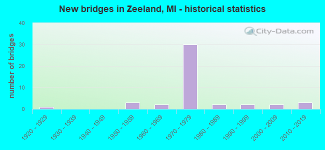
- New bridges - historical statistics
- 11920-1929
- 31950-1959
- 21960-1969
- 301970-1979
- 21980-1989
- 21990-1999
- 22000-2009
- 32010-2019


- Bridge Condition - Deck
- 16.7%Very good
- 36.7%Good
- 33.3%Satisfactory
- 6.7%Fair
- 3.3%Serious
- 3.3%Imminent failure

- Bridge Condition - Superstructure
- 20.0%Very good
- 33.3%Good
- 20.0%Satisfactory
- 13.3%Fair
- 6.7%Poor
- 3.3%Serious
- 3.3%Critical

- Bridge Condition - Substructure
- 6.7%Very good
- 46.7%Good
- 26.7%Satisfactory
- 13.3%Fair
- 6.7%Poor

- Bridge Condition - Channel
- 14.3%Very good
- 10.7%Good
- 39.3%Satisfactory
- 21.4%Fair
- 14.3%Poor

- Bridge Condition - Culverts
- 16.7%Very good
- 33.3%Good
- 33.3%Satisfactory
- 16.7%Fair
Find on map >> Show street view
Structure Number: 8746, Location: E LIMITS OF ZEELAND (Lat: 42.812242, Lng: -85.981428), Route carried "under" structure: Business Interstate 196, Year Built: 1972, Structure Length: 0. m, Average Daily Traffic: 28,554 (year 2007), Truck Traffic: 5%, Features Intersected: I-196BL (BYRON RD)
Minimum Vertical Clearance: 4.55m (14.93ft), Kilometerpoint: 11.790, Lanes on structure: 2, Lanes under structure: 5, Material/Design: Steel, Design/Construction: Stringer/Multi-beam, Length of Maximum Span: 27.7m (90.9ft)
Find on map >> Show street view
Structure Number: 13428, Location: 85 FT MI N OF ADAMS ST (Lat: 42.783683, Lng: -86.026919), Route carried "under" structure: Interstate 196, Year Built: 2010, Structure Length: 0. m, Average Daily Traffic: 25,700 (year 2006), Features Intersected: I-196, Facility Carried by Structure: NON-MOTORIZED PATH
Minimum Vertical Clearance: 5.61m (18.41ft), Kilometerpoint: 1.835, Lanes under structure: 4, Material/Design: Steel, Design/Construction: Truss - Thru, Length of Maximum Span: 71.6m (234.9ft)