Augusta, Arkansas
Submit your own pictures of this city and show them to the world
- OSM Map
- General Map
- Google Map
- MSN Map
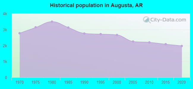
Population change since 2000: -27.8%
 |
| Males: 948 | |
| Females: 976 |
| Median resident age: | 44.7 years |
| Arkansas median age: | 38.9 years |
Zip codes: 72006.
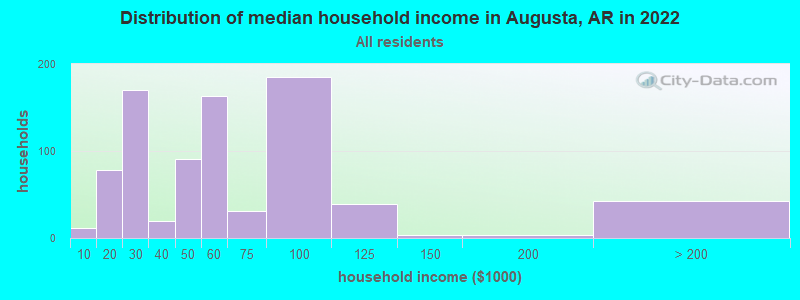
| Augusta: | $50,709 |
| AR: | $55,432 |
Estimated per capita income in 2022: $27,564 (it was $12,865 in 2000)
Augusta city income, earnings, and wages data
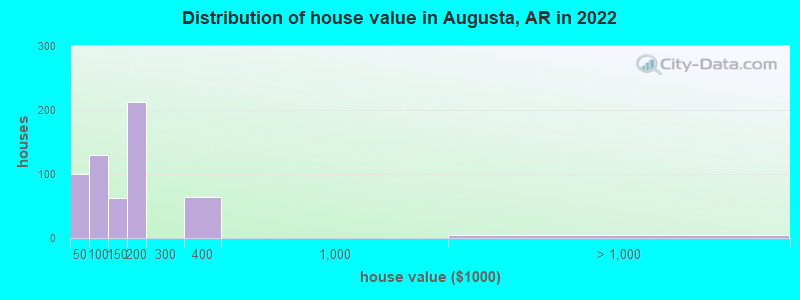
Estimated median house or condo value in 2022: $147,914 (it was $34,400 in 2000)
| Augusta: | $147,914 |
| AR: | $179,800 |
Mean prices in 2022: all housing units: $116,526; detached houses: $124,702; mobile homes: $40,962
Median gross rent in 2022: $584.
(10.7% for White Non-Hispanic residents, 23.1% for Black residents, 100.0% for Hispanic or Latino residents, 100.0% for other race residents)
Detailed information about poverty and poor residents in Augusta, AR

Compare current foreclosures near Augusta, AR:
| Photo | Address | Area | Beds / Baths | Price | Details |
|---|---|---|---|---|---|

|
#1
Magnolia St
Augusta, AR 72006
|
1,244 sq. feet
|
1 baths - beds |
show details | |

|
#2
Walnut St
Augusta, AR 72006
|
950 sq. feet
|
1 baths - beds |
show details | |

|
#3
N 7th St
Augusta, AR 72006
|
1,957 sq. feet
|
2 baths - beds |
show details | |

|
#4
Missile Base Rd
Judsonia, AR 72081
|
2,266 sq. feet
|
2 baths 3 beds |
show details | |

|
#5
Woodruff 413
Mc Crory, AR 72101
|
2,004 sq. feet
|
2 baths - beds |
show details | |

|
#6
May St
Bald Knob, AR 72010
|
1,421 sq. feet
|
1 baths - beds |
show details | |

|
#7
Hammons St
Judsonia, AR 72081
|
1,392 sq. feet
|
2 baths - beds |
show details | |

|
#8
Pumping Station Rd
Bald Knob, AR 72010
|
1,776 sq. feet
|
1 baths - beds |
show details | |

|
#9
Jackson 311
Bradford, AR 72020
|
1,368 sq. feet
|
1 baths - beds |
show details | |

|
#10
Walmsley Rd
Bald Knob, AR 72010
|
888 sq. feet
|
1 baths - beds |
show details |
| Photo | Address | Area | Beds / Baths | Price | Details |
|---|---|---|---|---|---|

|
#11
Richardson St
Bald Knob, AR 72010
|
1,040 sq. feet
|
1 baths - beds |
show details | |

|
#12
Meadow Lark Ln
Judsonia, AR 72081
|
1,276 sq. feet
|
1 baths - beds |
show details | |

|
#13
White Oak Dr
Judsonia, AR 72081
|
1,302 sq. feet
|
2 baths - beds |
show details | |

|
#14
Ralph Reed St
Judsonia, AR 72081
|
176 sq. feet
|
1 baths - beds |
show details | |

|
#15
Raymond Circle Dr
Mc Crory, AR 72101
|
1,254 sq. feet
|
1 baths - beds |
show details | |

|
#16
Old Russell Rd
Bald Knob, AR 72010
|
784 sq. feet
|
1 baths - beds |
show details | |

|
#17
Missile Base Rd
Judsonia, AR 72081
|
1,650 sq. feet
|
2 baths - beds |
show details | |

|
#18
Highway 258
Bald Knob, AR 72010
|
2,370 sq. feet
|
2 baths - beds |
show details | |

|
#19
Broadman St
Judsonia, AR 72081
|
- sq. feet
|
- baths - beds |
show details | |

|
#20
Bucks Rd
Judsonia, AR 72081
|
- sq. feet
|
- baths - beds |
show details |
| Photo | Address | Area | Beds / Baths | Price | Details |
|---|---|---|---|---|---|

|
#21
Highway 87
Bradford, AR 72020
|
- sq. feet
|
- baths - beds |
show details | |

|
#22
E Adams St
Judsonia, AR 72081
|
- sq. feet
|
- baths - beds |
show details | |

|
#23
Wells Rd
Bald Knob, AR 72010
|
- sq. feet
|
- baths - beds |
show details | |

|
#24
Judson Ave
Judsonia, AR 72081
|
924 sq. feet
|
- baths - beds |
show details | |

|
#25
Main St
Judsonia, AR 72081
|
- sq. feet
|
- baths - beds |
show details | |

|
#26
Jackson 93
Newport, AR 72112
|
- sq. feet
|
- baths - beds |
show details | |

|
#27
Highway 367 N
Judsonia, AR 72081
|
- sq. feet
|
- baths - beds |
show details | |

|
#28
Ralph Reed St
Judsonia, AR 72081
|
- sq. feet
|
- baths - beds |
show details | |

|
#29
Wells Rd
Bald Knob, AR 72010
|
- sq. feet
|
- baths - beds |
show details | |

|
#30
Forey St
Judsonia, AR 72081
|
1,872 sq. feet
|
- baths - beds |
show details |
| Photo | Address | Area | Beds / Baths | Price | Details |
|---|---|---|---|---|---|

|
#31
Velvet Ridge Rd
Bradford, AR 72020
|
- sq. feet
|
- baths - beds |
show details | |

|
#32
Jackson 25
Bradford, AR 72020
|
- sq. feet
|
- baths - beds |
show details | |

|
#33
N Main St Apt 4
Bald Knob, AR 72010
|
- sq. feet
|
- baths - beds |
show details | |

|
#34
Highway 87
Bradford, AR 72020
|
- sq. feet
|
- baths - beds |
show details | |

|
#35
Velvet Ridge Rd
Bradford, AR 72020
|
- sq. feet
|
- baths - beds |
show details | |

|
#36
Edens Rd
Bradford, AR 72020
|
- sq. feet
|
- baths - beds |
show details | |

|
#37
N Main St
Bald Knob, AR 72010
|
- sq. feet
|
- baths - beds |
show details | |

|
#38
May St Apt 28
Bald Knob, AR 72010
|
- sq. feet
|
- baths - beds |
show details | |

|
#39
Newell Rd
Bald Knob, AR 72010
|
2,128 sq. feet
|
- baths - beds |
show details | |

|
#40
Strawberry St
Bald Knob, AR 72010
|
- sq. feet
|
- baths - beds |
show details |
| Photo | Address | Area | Beds / Baths | Price | Details |
|---|---|---|---|---|---|

|
#41
Highway 167 N
Bald Knob, AR 72010
|
- sq. feet
|
- baths - beds |
show details | |

|
#42
S Collison Ave
Bald Knob, AR 72010
|
- sq. feet
|
- baths - beds |
show details | |

|
#43
W Baker St
Searcy, AR 72143
|
- sq. feet
|
- baths - beds |
show details | |

|
#44
Velvet Ridge Rd
Bradford, AR 72020
|
- sq. feet
|
- baths - beds |
show details | |

|
#45
Camelia Ln
Bald Knob, AR 72010
|
- sq. feet
|
- baths - beds |
show details | |

|
#46
Capps Rd
Judsonia, AR 72081
|
- sq. feet
|
- baths - beds |
show details | |

|
#47
S Waller Rd
Bald Knob, AR 72010
|
- sq. feet
|
- baths - beds |
show details | |

|
#48
Edens Rd
Bradford, AR 72020
|
- sq. feet
|
- baths - beds |
show details | |

|
#49
Missile Base Rd
Judsonia, AR 72081
|
- sq. feet
|
- baths - beds |
show details | |

|
Check over 1 million property listings on Foreclosure.com!
|
browse all offers | |||


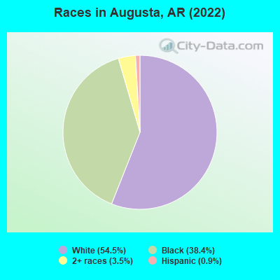
- 1,09754.5%White alone
- 77238.4%Black alone
- 703.5%Two or more races
- 180.9%Hispanic
- 10.05%American Indian alone
According to our research of Arkansas and other state lists, there were 5 registered sex offenders living in Augusta, Arkansas as of April 26, 2024.
The ratio of all residents to sex offenders in Augusta is 480 to 1.
The ratio of registered sex offenders to all residents in this city is near the state average.
Type |
2009 |
2010 |
2011 |
2012 |
2014 |
2015 |
2016 |
2017 |
2018 |
2019 |
2020 |
2021 |
2022 |
|---|---|---|---|---|---|---|---|---|---|---|---|---|---|
| Murders (per 100,000) | 0 (0.0) | 0 (0.0) | 0 (0.0) | 0 (0.0) | 0 (0.0) | 0 (0.0) | 0 (0.0) | 0 (0.0) | 0 (0.0) | 0 (0.0) | 0 (0.0) | 0 (0.0) | 0 (0.0) |
| Rapes (per 100,000) | 0 (0.0) | 0 (0.0) | 0 (0.0) | 1 (45.5) | 2 (93.1) | 1 (48.0) | 1 (49.4) | 0 (0.0) | 0 (0.0) | 5 (257.9) | 3 (156.5) | 1 (52.6) | 0 (0.0) |
| Robberies (per 100,000) | 1 (45.2) | 0 (0.0) | 0 (0.0) | 1 (45.5) | 0 (0.0) | 1 (48.0) | 1 (49.4) | 0 (0.0) | 0 (0.0) | 0 (0.0) | 1 (52.2) | 0 (0.0) | 1 (51.9) |
| Assaults (per 100,000) | 7 (316.7) | 0 (0.0) | 0 (0.0) | 0 (0.0) | 6 (279.2) | 4 (191.9) | 7 (345.8) | 3 (150.5) | 2 (102.1) | 7 (361.0) | 3 (156.5) | 3 (157.9) | 1 (51.9) |
| Burglaries (per 100,000) | 5 (226.2) | 0 (0.0) | 0 (0.0) | 3 (136.5) | 18 (837.6) | 20 (959.7) | 15 (741.1) | 16 (802.8) | 16 (817.2) | 4 (206.3) | 7 (365.2) | 1 (52.6) | 5 (259.3) |
| Thefts (per 100,000) | 35 (1,584) | 2 (91.0) | 0 (0.0) | 37 (1,684) | 16 (744.5) | 33 (1,583) | 23 (1,136) | 24 (1,204) | 40 (2,043) | 25 (1,289) | 9 (469.5) | 6 (315.8) | 10 (518.7) |
| Auto thefts (per 100,000) | 0 (0.0) | 0 (0.0) | 0 (0.0) | 1 (45.5) | 0 (0.0) | 0 (0.0) | 0 (0.0) | 2 (100.4) | 1 (51.1) | 2 (103.1) | 1 (52.2) | 1 (52.6) | 0 (0.0) |
| Arson (per 100,000) | 2 (90.5) | 0 (0.0) | 0 (0.0) | 1 (45.5) | 1 (46.5) | 0 (0.0) | 2 (98.8) | 0 (0.0) | 0 (0.0) | 0 (0.0) | 1 (52.2) | 0 (0.0) | 0 (0.0) |
| City-Data.com crime index | 156.1 | 3.6 | 0.0 | 130.6 | 218.7 | 221.7 | 220.8 | 142.5 | 163.4 | 352.8 | 220.7 | 94.2 | 64.8 |
The City-Data.com crime index weighs serious crimes and violent crimes more heavily. Higher means more crime, U.S. average is 246.1. It adjusts for the number of visitors and daily workers commuting into cities.
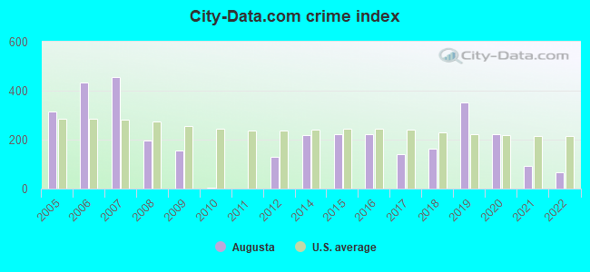
Crime rate in Augusta detailed stats: murders, rapes, robberies, assaults, burglaries, thefts, arson
Full-time law enforcement employees in 2021, including police officers: 5 (5 officers - 5 male; 0 female).
| Officers per 1,000 residents here: | 2.63 |
| Arkansas average: | 2.25 |
 Recent articles from our blog. Our writers, many of them Ph.D. graduates or candidates, create easy-to-read articles on a wide variety of topics.


 | Potentially Relocating to NW Arkansas...Need Advice (12 replies) |
| HELP! can an x-New York City girl, now living in SEattle find her place in AR??? (47 replies) |
| DOWNTOWN RESIDENTS! Voice your opinions on what we need more of! (24 replies) |
| Little Rock, a review. (124 replies) |
| Visiting Augusta area in Spring anyone know about hotels in the area? (1 reply) |
| Short List (60 replies) |
Latest news from Augusta, AR collected exclusively by city-data.com from local newspapers, TV, and radio stations
Ancestries: American (21.4%), Irish (14.6%), African (5.4%), English (4.6%), German (1.0%).
Current Local Time: CST time zone
Incorporated on 07/09/1860
Elevation: 215 feet
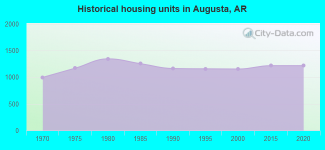
Land area: 1.96 square miles.
Population density: 980 people per square mile (low).
12 residents are foreign born
| This city: | 0.5% |
| Arkansas: | 2.8% |
Median real estate property taxes paid for housing units with mortgages in 2022: $636 (0.4%)
Median real estate property taxes paid for housing units with no mortgage in 2022: $912 (0.6%)
Nearest city with pop. 50,000+: Jonesboro, AR  (53.0 miles , pop. 55,515).
Nearest city with pop. 200,000+: Memphis, TN (79.4 miles , pop. 650,100).
Nearest city with pop. 1,000,000+: Dallas, TX (355.3 miles , pop. 1,188,580).
Nearest cities:
), ), Latitude: 35.29 N, Longitude: 91.36 W
Area code: 870
Augusta, Arkansas accommodation & food services - Economy and Business Data
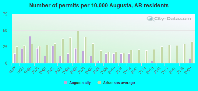
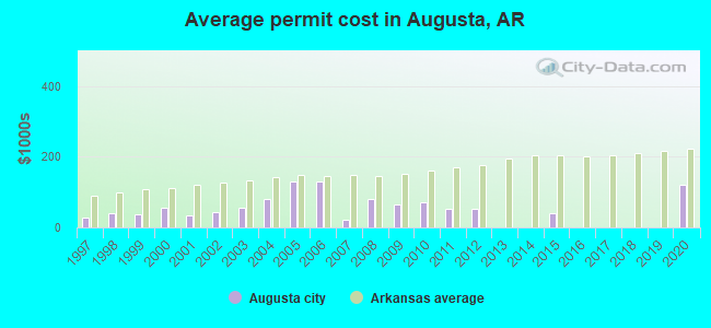
Single-family new house construction building permits:
- 2020: 2 buildings, average cost: $120,000
- 2015: 1 building, cost: $40,000
- 2012: 4 buildings, average cost: $52,500
- 2011: 4 buildings, average cost: $52,500
- 2010: 4 buildings, average cost: $72,000
- 2009: 4 buildings, average cost: $64,300
- 2008: 1 building, cost: $82,000
- 2007: 3 buildings, average cost: $22,000
- 2006: 5 buildings, average cost: $128,800
- 2005: 6 buildings, average cost: $128,800
- 2004: 4 buildings, average cost: $81,900
- 2003: 3 buildings, average cost: $55,000
- 2002: 7 buildings, average cost: $44,100
- 2001: 3 buildings, average cost: $33,300
- 2000: 6 buildings, average cost: $56,800
- 1999: 11 buildings, average cost: $35,600
- 1998: 6 buildings, average cost: $40,200
- 1997: 4 buildings, average cost: $28,000
| Here: | 4.1% |
| Arkansas: | 3.4% |
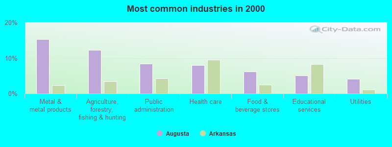
- Metal & metal products (15.2%)
- Agriculture, forestry, fishing & hunting (12.2%)
- Public administration (8.3%)
- Health care (8.0%)
- Food & beverage stores (6.2%)
- Educational services (5.0%)
- Utilities (4.2%)
- Agriculture, forestry, fishing & hunting (23.8%)
- Metal & metal products (16.3%)
- Public administration (9.0%)
- Truck transportation (6.9%)
- Utilities (5.6%)
- Construction (5.2%)
- Food & beverage stores (4.2%)
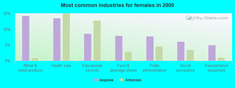
- Metal & metal products (14.3%)
- Health care (13.6%)
- Educational services (8.7%)
- Food & beverage stores (8.0%)
- Public administration (7.8%)
- Social assistance (6.2%)
- Transportation equipment (5.1%)
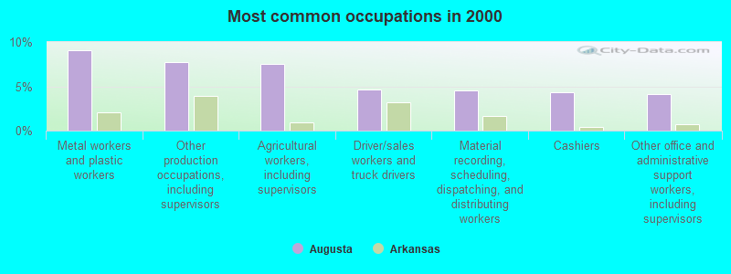
- Metal workers and plastic workers (9.0%)
- Other production occupations, including supervisors (7.8%)
- Agricultural workers, including supervisors (7.5%)
- Driver/sales workers and truck drivers (4.7%)
- Material recording, scheduling, dispatching, and distributing workers (4.6%)
- Cashiers (4.4%)
- Other office and administrative support workers, including supervisors (4.1%)
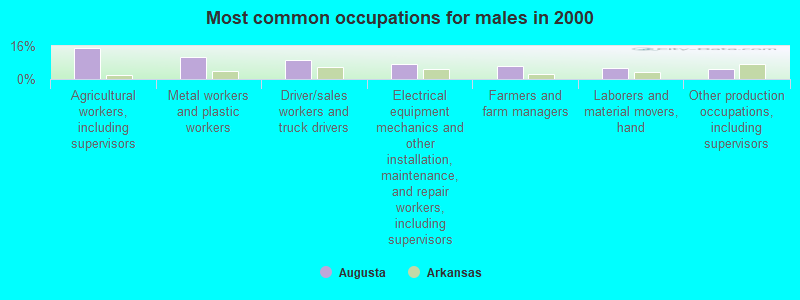
- Agricultural workers, including supervisors (15.1%)
- Metal workers and plastic workers (10.7%)
- Driver/sales workers and truck drivers (9.0%)
- Electrical equipment mechanics and other installation, maintenance, and repair workers, including supervisors (7.3%)
- Farmers and farm managers (6.3%)
- Laborers and material movers, hand (5.4%)
- Other production occupations, including supervisors (5.0%)
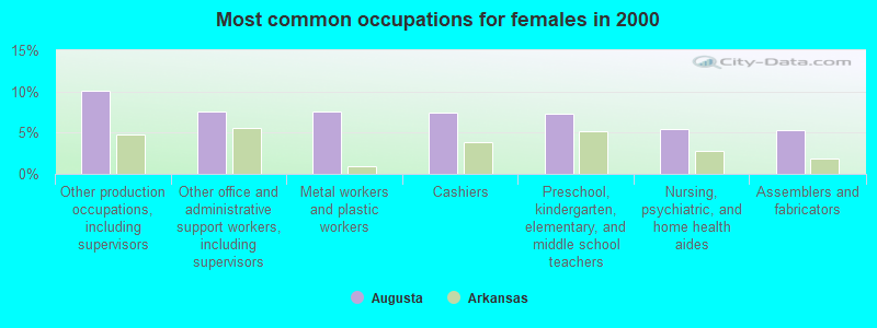
- Other production occupations, including supervisors (10.1%)
- Other office and administrative support workers, including supervisors (7.6%)
- Metal workers and plastic workers (7.6%)
- Cashiers (7.4%)
- Preschool, kindergarten, elementary, and middle school teachers (7.2%)
- Nursing, psychiatric, and home health aides (5.4%)
- Assemblers and fabricators (5.3%)
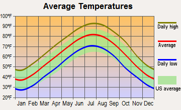
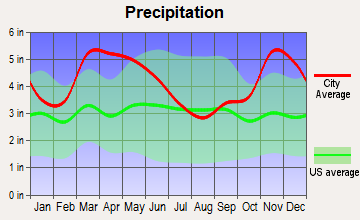
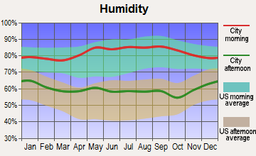
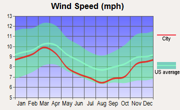
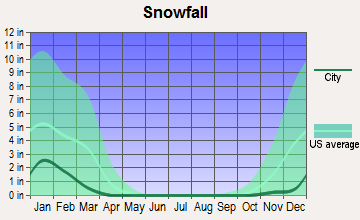
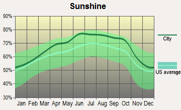
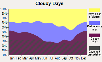
Average climate in Augusta, Arkansas
Based on data reported by over 4,000 weather stations
|
|


Tornado activity:
Augusta-area historical tornado activity is slightly above Arkansas state average. It is 156% greater than the overall U.S. average.
On 5/26/1973, a category F4 (max. wind speeds 207-260 mph) tornado 1.3 miles away from the Augusta city center killed 3 people and injured 289 people and caused between $5000 and $50,000 in damages.
On 3/21/1952, a category F4 tornado 10.7 miles away from the city center killed 50 people and injured 325 people and caused between $500,000 and $5,000,000 in damages.
Earthquake activity:
Augusta-area historical earthquake activity is significantly above Arkansas state average. It is 457% greater than the overall U.S. average.On 3/25/1976 at 00:41:20, a magnitude 5.0 (4.9 MB, 5.0 LG, Class: Moderate, Intensity: VI - VII) earthquake occurred 63.1 miles away from the city center
On 5/4/2001 at 06:42:12, a magnitude 4.7 (4.2 MB, 4.7 LG, 4.5 LG, Class: Light, Intensity: IV - V) earthquake occurred 47.4 miles away from Augusta center
On 1/21/1982 at 00:33:54, a magnitude 4.7 (4.5 MB, 4.7 LG, 4.5 LG) earthquake occurred 48.5 miles away from the city center
On 2/28/2011 at 05:00:50, a magnitude 4.7 (4.7 MW, Depth: 2.0 mi) earthquake occurred 56.1 miles away from the city center
On 5/4/1991 at 01:18:54, a magnitude 5.0 (4.4 MB, 4.6 LG, 5.0 LG, Depth: 3.1 mi) earthquake occurred 123.4 miles away from Augusta center
On 3/25/1976 at 01:00:11, a magnitude 4.5 (4.1 MB, 4.5 LG) earthquake occurred 54.4 miles away from the city center
Magnitude types: regional Lg-wave magnitude (LG), body-wave magnitude (MB), moment magnitude (MW)
Natural disasters:
The number of natural disasters in Woodruff County (21) is greater than the US average (15).Major Disasters (Presidential) Declared: 16
Emergencies Declared: 3
Causes of natural disasters: Storms: 16, Floods: 14, Tornadoes: 10, Winter Storms: 3, Winds: 2, Hurricane: 1, Landslide: 1, Other: 1 (Note: some incidents may be assigned to more than one category).
Hospitals and medical centers in Augusta:
Airports and heliports located in Augusta:
- Woodruff County Airport (M60) (Runways: 1, Itinerant Ops: 500, Local Ops: 5,000)
- Augusta Heliport (AR76)
Colleges/universities with over 2000 students nearest to Augusta:
- Harding University (about 21 miles; Searcy, AR; Full-time enrollment: 5,360)
- Arkansas State University-Beebe (about 34 miles; Beebe, AR; FT enrollment: 3,387)
- Arkansas State University-Main Campus (about 55 miles; Jonesboro, AR; FT enrollment: 12,323)
- Pulaski Technical College (about 64 miles; North Little Rock, AR; FT enrollment: 8,396)
- University of Central Arkansas (about 64 miles; Conway, AR; FT enrollment: 9,972)
- University of Arkansas at Little Rock (about 68 miles; Little Rock, AR; FT enrollment: 9,227)
- Southwest Tennessee Community College (about 76 miles; Memphis, TN; FT enrollment: 8,043)
Public high school in Augusta:
- AUGUSTA HIGH SCHOOL (Location: 206 SMITH DR, Grades: 7-12)
Public elementary/middle school in Augusta:
- AUGUSTA ELEMENTARY SCHOOL (Location: 1011 MAIN ST, Grades: PK-6)
Points of interest:
Notable locations in Augusta: Woodruff County Courthouse (A), Augusta Volunteer Fire Department (B), Southern Paramedic Service - Augusta (C), Augusta Police Department (D), Woodruff County Sheriff's Office (E). Display/hide their locations on the map
Churches in Augusta include: Augusta Presbyterian Church (A), First Baptist Church of Augusta (B). Display/hide their locations on the map
Cemetery: Quiett Cemetery (1). Display/hide its location on the map
Tourist attractions: White River Regional Housing Author (Recreation Areas; Melbourne), Augusta Motor Lodge (Highway 64 West).
Hotel: Augusta Motor Lodge (Highway 64 West).
Court: Augusta City - Municipal Court (118 South 2nd Street).
Birthplace of: Jimmy Gunn - Football player, Victor Rodman - Actor.
Drinking water stations with addresses in Augusta that have no violations reported:
- AUGUSTA WATERWORKS (Population served: 2,199, Primary Water Source Type: Groundwater)
| This city: | 2.2 people |
| Arkansas: | 2.5 people |
| This city: | 62.5% |
| Whole state: | 67.6% |
| This city: | 4.9% |
| Whole state: | 5.7% |
Likely homosexual households (counted as self-reported same-sex unmarried-partner households)
- Lesbian couples: 0.1% of all households
- Gay men: 0.1% of all households
17 people in homes for the mentally ill in 2000
12 people in local jails and other confinement facilities (including police lockups) in 2000
Banks with branches in Augusta (2011 data):
- The Bank of Augusta: The Bank Of Augusta at 100 South Second Street, branch established on 1935/03/04; Hwy 64 Branch at Highway 64, branch established on 1996/02/28. Info updated 2011/12/02: Bank assets: $62.4 mil, Deposits: $53.6 mil, local headquarters, positive income, 2 total offices
For population 15 years and over in Augusta:
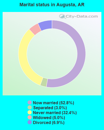
- Never married: 32.4%
- Now married: 52.8%
- Separated: 3.0%
- Widowed: 5.0%
- Divorced: 6.9%
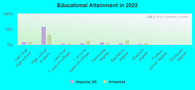
For population 25 years and over in Augusta:
- High school or higher: 89.3%
- Bachelor's degree or higher: 10.3%
- Graduate or professional degree: 4.5%
- Unemployed: 11.0%
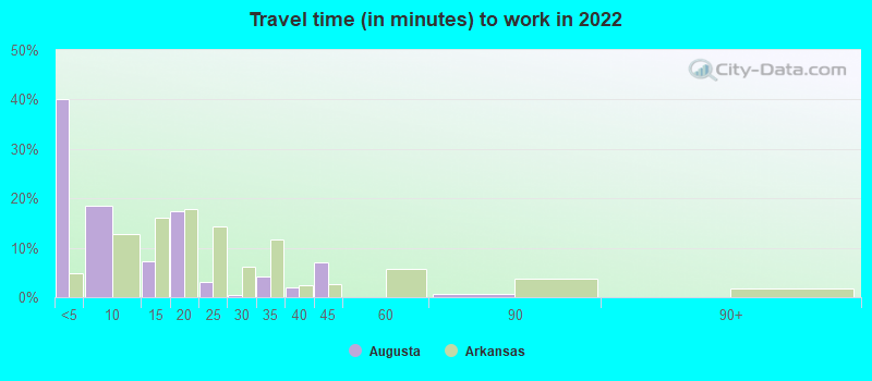
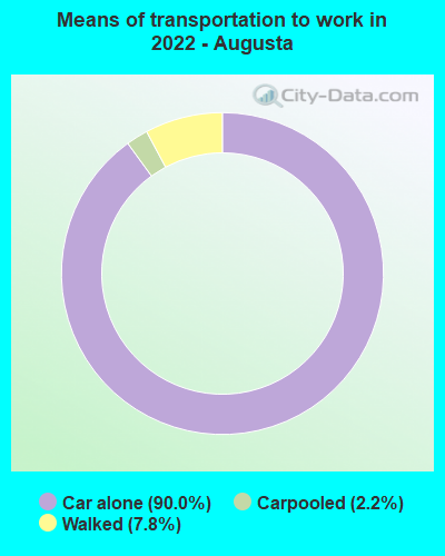
- Mean travel time to work (commute): 14.5 minutes
| Here: | 8.0 |
| Arkansas average: | 11.4 |
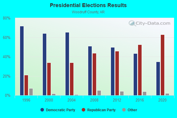
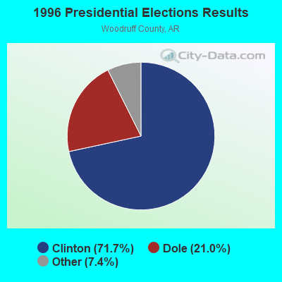
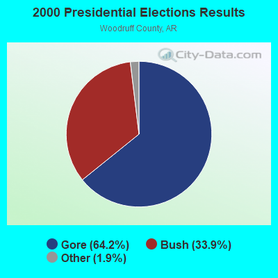
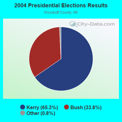
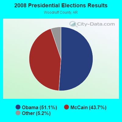
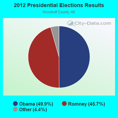
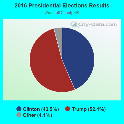
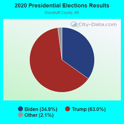
Graphs represent county-level data. Detailed 2008 Election Results
Religion statistics for Augusta, AR (based on Woodruff County data)
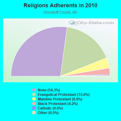
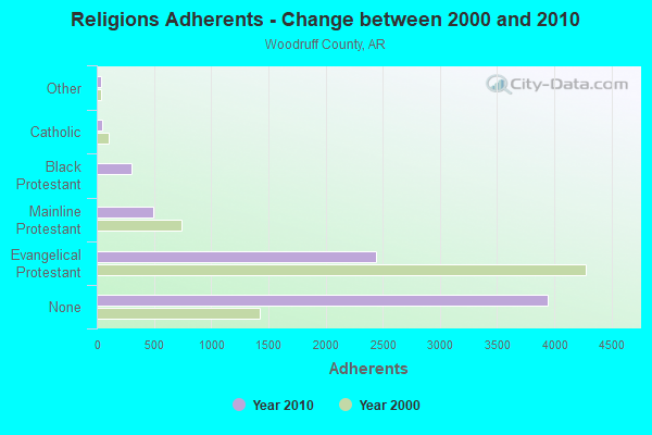
| Religion | Adherents | Congregations |
|---|---|---|
| Evangelical Protestant | 2,440 | 19 |
| Mainline Protestant | 491 | 6 |
| Black Protestant | 303 | 2 |
| Catholic | 45 | 1 |
| Other | 38 | - |
| None | 3,943 | - |
Food Environment Statistics:
| Woodruff County: | 5.24 / 10,000 pop. |
| Arkansas: | 2.02 / 10,000 pop. |
| Woodruff County: | 1.31 / 10,000 pop. |
| Arkansas: | 0.59 / 10,000 pop. |
| Woodruff County: | 5.24 / 10,000 pop. |
| State: | 4.94 / 10,000 pop. |
| Here: | 2.62 / 10,000 pop. |
| State: | 6.66 / 10,000 pop. |
| This county: | 10.9% |
| Arkansas: | 9.8% |
| Woodruff County: | 30.9% |
| Arkansas: | 29.1% |
| This county: | 7.5% |
| State: | 13.6% |
Health and Nutrition:
| Augusta: | 46.5% |
| Arkansas: | 48.2% |
| This city: | 42.9% |
| Arkansas: | 44.2% |
| This city: | 30.4 |
| Arkansas: | 28.9 |
| Augusta: | 18.6% |
| Arkansas: | 21.6% |
| Augusta: | 15.6% |
| Arkansas: | 11.3% |
| This city: | 6.6 |
| State: | 6.8 |
| Augusta: | 35.6% |
| Arkansas: | 34.0% |
| This city: | 51.6% |
| Arkansas: | 54.4% |
| Augusta: | 83.8% |
| Arkansas: | 78.0% |
More about Health and Nutrition of Augusta, AR Residents
| Local government employment and payroll (March 2022) | |||||
| Function | Full-time employees | Monthly full-time payroll | Average yearly full-time wage | Part-time employees | Monthly part-time payroll |
|---|---|---|---|---|---|
| Police Protection - Officers | 5 | $11,566 | $27,758 | 0 | $0 |
| Other Government Administration | 5 | $13,442 | $32,261 | 19 | $34,665 |
| Solid Waste Management | 4 | $9,378 | $28,134 | 0 | $0 |
| Streets and Highways | 4 | $13,729 | $41,187 | 0 | $0 |
| Parks and Recreation | 4 | $9,378 | $28,134 | 0 | $0 |
| Electric Power | 3 | $15,861 | $63,444 | 0 | $0 |
| Sewerage | 2 | $7,477 | $44,862 | 0 | $0 |
| Water Supply | 1 | $3,246 | $38,952 | 0 | $0 |
| Other and Unallocable | 1 | $2,206 | $26,472 | 0 | $0 |
| Judicial and Legal | 0 | $0 | 4 | $12,362 | |
| Totals for Government | 29 | $86,283 | $35,703 | 23 | $47,027 |
Augusta government finances - Expenditure in 2021 (per resident):
- Current Operations - Electric Utilities: $1,484,000 ($771.31)
Financial Administration: $874,000 ($454.26)
Police Protection: $444,000 ($230.77)
Gas Utilities: $407,000 ($211.54)
Solid Waste Management: $295,000 ($153.33)
Water Utilities: $195,000 ($101.35)
Regular Highways: $188,000 ($97.71)
Sewerage: $172,000 ($89.40)
Judicial and Legal Services: $118,000 ($61.33)
Local Fire Protection: $71,000 ($36.90)
Health - Other: $67,000 ($34.82)
General - Other: $2,000 ($1.04)
- General - Interest on Debt: $13,000 ($6.76)
- Other Capital Outlay - General - Other: $48,000 ($24.95)
Sewerage: $14,000 ($7.28)
Regular Highways: $5,000 ($2.60)
Augusta government finances - Revenue in 2021 (per resident):
- Charges - Solid Waste Management: $317,000 ($164.76)
Sewerage: $224,000 ($116.42)
Other: $35,000 ($18.19)
- Local Intergovernmental - General Local Government Support: $250,000 ($129.94)
- Miscellaneous - Interest Earnings: $38,000 ($19.75)
General Revenue - Other: $20,000 ($10.40)
- Revenue - Electric Utilities: $1,591,000 ($826.92)
Gas Utilities: $462,000 ($240.12)
Water Utilities: $252,000 ($130.98)
- State Intergovernmental - Other: $298,000 ($154.89)
Highways: $133,000 ($69.13)
General Local Government Support: $47,000 ($24.43)
- Tax - Property: $476,000 ($247.40)
General Sales and Gross Receipts: $436,000 ($226.61)
Other License: $9,000 ($4.68)
Augusta government finances - Debt in 2021 (per resident):
- Long Term Debt - Beginning Outstanding - Unspecified Public Purpose: $585,000 ($304.05)
Outstanding Unspecified Public Purpose: $557,000 ($289.50)
Retired Unspecified Public Purpose: $28,000 ($14.55)
Augusta government finances - Cash and Securities in 2021 (per resident):
- Other Funds - Cash and Securities: $1,561,000 ($811.33)
Businesses in Augusta, AR
- Subway: 1
Strongest AM radio stations in Augusta:
- KGHT (880 AM; 50 kW; SHERIDAN, AR; Owner: METROPOLITAN RADIO GROUP, INC.)
- WCRV (640 AM; 50 kW; COLLIERVILLE, TN; Owner: BOTT BROADCASTING COMPANY/TENNESSEE)
- KAAY (1090 AM; 50 kW; LITTLE ROCK, AR; Owner: CITADEL BROADCASTING COMPANY)
- KWCK (1300 AM; daytime; 5 kW; SEARCY, AR; Owner: CALDWELL BROADCASTING, LLC)
- WDIA (1070 AM; 50 kW; MEMPHIS, TN; Owner: CLEAR CHANNEL BROADCASTING LICENSES, INC.)
- WGSF (1030 AM; 50 kW; MEMPHIS, TN; Owner: FLINN BROADCASTING CORPORATION)
- KXJK (950 AM; 5 kW; FORREST CITY, AR; Owner: FORREST CITY BROADCASTING CO., INC.)
- WMQM (1600 AM; 50 kW; LAKELAND, TN; Owner: WMQM, INC.)
- KMTL (760 AM; daytime; 10 kW; SHERWOOD, AR; Owner: GEORGE V. DOMERESE)
- KAPZ (710 AM; daytime; 0 kW; BALD KNOB, AR; Owner: CALDWELL BROADCASTING, LLC)
- WJCE (680 AM; 10 kW; MEMPHIS, TN; Owner: ENTERCOM MEMPHIS LICENSE, LLC)
- WCPC (940 AM; 50 kW; HOUSTON, MS; Owner: WCPC BROADCASTING CO., INC.)
- KWAM (990 AM; 10 kW; MEMPHIS, TN; Owner: CONCORD MEDIA GROUP, INC.)
Strongest FM radio stations in Augusta:
- KABK-FM (97.7 FM; AUGUSTA, AR; Owner: FAMILY WORSHIP CENTER CHURCH, INC.)
- KOKR (96.7 FM; NEWPORT, AR; Owner: NEWPORT BROADCASTING COMPANY)
- KBDO (91.7 FM; DES ARC, AR; Owner: AMERICAN FAMILY ASSOCIATION)
- KKSY (107.1 FM; BALD KNOB, AR; Owner: CALDWELL BROADCASTING, LLC)
TV broadcast stations around Augusta:
- KAIT (Channel 8; JONESBORO, AR; Owner: LIBCO, INC.)
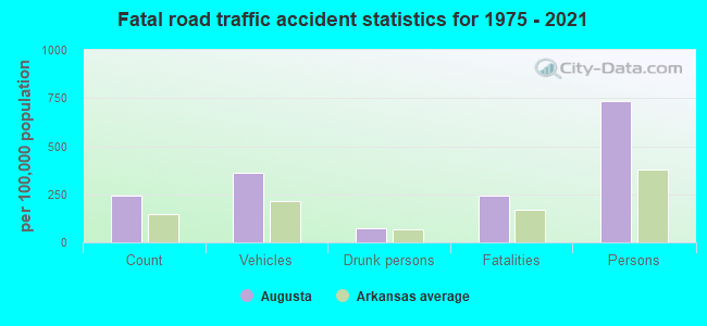
Augusta fatal accident list:
Aug 3, 2003 08:40 PM, Us-64-13, Vehicles: 2, Persons: 3, Fatalities: 1
May 31, 1999 10:00 PM, Us-64-13c, Vehicles: 1, Persons: 1, Fatalities: 1, Drunk persons involved: 1
Aug 8, 1987 09:18 PM, Thirdst, Vehicles: 2, Persons: 3, Fatalities: 1
Sep 26, 1984 07:54 PM, 33s7c, Vehicles: 1, Persons: 2, Fatalities: 1, Drunk persons involved: 1
Oct 23, 1983 07:01 PM, 64s13, Vehicles: 1, Persons: 2, Fatalities: 1
Dec 14, 1980 06:25 AM, Vehicles: 1, Persons: 2, Fatalities: 1
- National Bridge Inventory (NBI) Statistics
- 10Number of bridges
- 203ft / 62.3mTotal length
- $732,000Total costs
- 34,594Total average daily traffic
- 6,633Total average daily truck traffic
- 40,816Total future (year 2007) average daily traffic
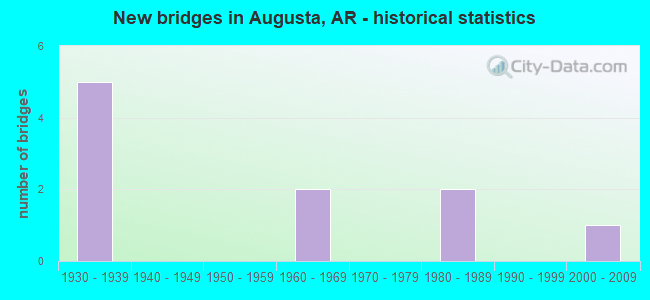
- New bridges - historical statistics
- 51930-1939
- 21960-1969
- 21980-1989
- 12000-2009
FCC Registered Antenna Towers:
41 (See the full list of FCC Registered Antenna Towers in Augusta)FCC Registered Commercial Land Mobile Towers:
1- Call Sign: KR7855,
Assigned Frequencies: 450.700 MHz, Grant Date: 01/28/1980, Expiration Date: 06/01/2028, Registrant: Family Worship Center Church, Inc., 8919 World Ministry Avenue, Baton Rouge, LA 70810
FCC Registered Broadcast Land Mobile Towers:
6- 500 N Third (Lat: 35.282028 Lon: -91.367361), Call Sign: KSK938,
Assigned Frequencies: 37.2000 MHz, 37.2400 MHz, 37.3600 MHz, Grant Date: 09/19/1996, Expiration Date: 12/04/2001, Cancellation Date: 05/05/2002, Registrant: County Of Woodruff, 500 N 3rd St, Augusta, AR 72006
- 5 Mi S Gregory On Hwy 33 (Lat: 35.079806 Lon: -91.369583), Call Sign: KNAY367, Licensee ID: L00342754,
Assigned Frequencies: 152.300 MHz, Grant Date: 04/05/2001, Expiration Date: 04/24/2011, Cancellation Date: 06/25/2011, Registrant: Don Pfeffer, Rt 2 Box 129, Augusta, AR 72006, Phone: (501) 347-2471
- Hwy 33 S (Lat: 35.284806 Lon: -91.350417), Structure height: 8 m, Call Sign: WPAF763,
Assigned Frequencies: 158.460 MHz, Grant Date: 05/22/1997, Expiration Date: 08/04/2002, Cancellation Date: 07/03/2002, Registrant: Sloan Valve Co, Augusta, AR 72006, Phone: (501) 347-2503
- Hwy 339 S (Lat: 35.252861 Lon: -91.356250), Call Sign: KGW557,
Assigned Frequencies: 47.9600 MHz, Grant Date: 11/29/2023, Expiration Date: 02/15/2034, Registrant: Arkansas Electric Cooperative Corporation, 1 Cooperative Way, Little Rock, AR 72209, Phone: (501) 570-2636, Email:
- Jct Arkansas Rt 33 & Us 64 (Lat: 35.293694 Lon: -91.358472), Call Sign: KKG744, Licensee ID: L00008879,
Assigned Frequencies: 37.8200 MHz, Grant Date: 09/03/2022, Expiration Date: 11/30/2032, Registrant: Woodruff Electric Cooperative Corp, 3201 Highway 1 North, Forrest City, AR 72336-1619, Phone: (870) 633-2262, Fax: (870) 633-0629, Email:
- Lat: 35.268278 Lon: -91.345944, Call Sign: WRVS785,
Assigned Frequencies: 451.737 MHz, 452.637 MHz, 457.637 MHz, 462.487 MHz, 467.512 MHz, Grant Date: 12/31/2022, Expiration Date: 12/31/2032, Certifier: Craig Parsley, Registrant: Mj Communications, North Little Rock, AR 72231, Phone: (501) 945-9307, Fax: (501) 945-0333, Email:
FCC Registered Microwave Towers:
3- STATION, Near Int Of Us 64 And Sr 33 At N Edge Of (Lat: 35.293694 Lon: -91.358444), Overall height: 59.4 m, Call Sign: WNEY722,
Assigned Frequencies: 6765.00 MHz, Grant Date: 11/25/2019, Expiration Date: 10/13/2029, Registrant: Woodruff Electric Cooperative, 3201 Highway 1 North, Forrest City, AR 72335, Phone: (870) 633-2262, Fax: (870) 633-6241, Email:
- AR01075A, 275 South 9th Street (Lat: 35.281556 Lon: -91.357528), Type: Gtower, Structure height: 85.3 m, Overall height: 89.9 m, Call Sign: WQWD209,
Assigned Frequencies: 10915.0 MHz, 10915.0 MHz, 10915.0 MHz, 10915.0 MHz, 10915.0 MHz, 10915.0 MHz, 10915.0 MHz, 10915.0 MHz, 10915.0 MHz, 10915.0 MHz... (+9 more), Grant Date: 07/21/2015, Expiration Date: 07/21/2025, Certifier: David Werblow, Registrant: T-Mobile Usa, Inc., 12920 Se 38th Street, Bellevue, WA 98006, Phone: (425) 383-8401, Fax: (425) 383-4040, Email:
- 704 North 9th (Lat: 35.289806 Lon: -91.357611), Overall height: 24.4 m, Call Sign: WFW711, Licensee ID: L00505673,
Assigned Frequencies: 949.850 MHz, 950.150 MHz, Grant Date: 10/05/1982, Expiration Date: 06/01/2028, Registrant: Family Worship Center Church, Inc., 8919 World Ministry Avenue, Baton Rouge, LA 70810
FCC Registered Amateur Radio Licenses:
7- Call Sign: KA5YOI, Licensee ID: L00380320, Grant Date: 10/18/2005, Expiration Date: 01/16/2016, Cancellation Date: 01/17/2018, Certifier: Johnnie Mc Cabe, Registrant: Johnnie Mc Cabe, Rt 2 Box 352, Augusta, AR 72006
- Call Sign: KG5SB, Licensee ID: L01478833, Grant Date: 02/02/2019, Expiration Date: 03/31/2029, Registrant: William N Gregory, 300 South Second Street, Augusta, AR 72006
- Call Sign: KJ5UT, Previous Call Sign: KB5QVL, Licensee ID: L01100928, Grant Date: 12/31/2005, Expiration Date: 12/31/2015, Cancellation Date: 01/03/2018, Registrant: John W Revel, 2489 Hwy 260, Augusta, AR 72006
- Call Sign: N5YKF, Licensee ID: L00426446, Grant Date: 11/30/2001, Expiration Date: 01/21/2012, Cancellation Date: 01/22/2014, Certifier: Thelma L Revel, Registrant: Thelma L Revel, 2489 Hwy 260, Augusta, AR 72006
- Call Sign: NR5I, Grant Date: 07/25/1994, Expiration Date: 07/25/2004, Cancellation Date: 07/26/2006, Registrant: Joseph H Stanley Jr, Rt 2 Box 191, Augusta, AR 72006
- Call Sign: WL7AIU, Licensee ID: L01008429, Grant Date: 03/09/2015, Expiration Date: 04/26/2025, Certifier: William C Howerton, Registrant: William C Howerton, 1008 N 14th St, Augusta, AR 72006
- Call Sign: KI5SDG, Licensee ID: L02493454, Grant Date: 10/15/2021, Expiration Date: 10/15/2031, Certifier: Jackie Carter, Registrant: Jackie Carter, 816 S 9th St, Augusta, AR 72006
FAA Registered Aircraft:
2- Aircraft: BEECH D55 (Category: Land, Engines: 2, Seats: 6, Weight: Up to 12,499 Pounds, Speed: 165 mph), Engine: CONT MOTOR IO 520 SERIES (285 HP) (Reciprocating)
N-Number: 7725R, N7725R, N-7725R, Serial Number: TE-644, Year manufactured: 1968, Airworthiness Date: 10/23/1968, Certificate Issue Date: 01/15/2013
Registrant (LLC): Lynn Cain LLC, 7921 Highway 64 E, Augusta, AR 72006 - Aircraft: PIPER J3F-65 (Category: Land, Seats: 2, Weight: Up to 12,499 Pounds, Speed: 67 mph), Engine: CONT MOTOR C85 SERIES (85 HP) (Reciprocating)
N-Number: 35563, N35563, N-35563, Serial Number: 6469, Year manufactured: 1946, Airworthiness Date: 10/08/1981, Certificate Issue Date: 10/14/1963
Registrant (Individual): Joseph H Jr Stanley, Po Box 90, Augusta, AR 72006
Deregistered: Cancel Date: 07/20/2017
2004 - 2018 National Fire Incident Reporting System (NFIRS) incidents
- Fire incident types reported to NFIRS in Augusta, AR
- 23841.0%Outside Fires
- 22638.9%Structure Fires
- 8915.3%Mobile Property/Vehicle Fires
- 284.8%Other
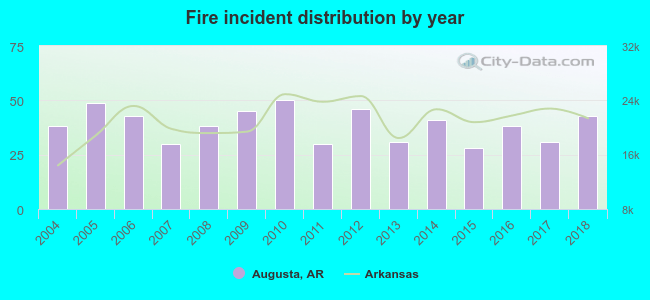 According to the data from the years 2004 - 2018 the average number of fire incidents per year is 39. The highest number of reported fires - 50 took place in 2010, and the least - 28 in 2015. The data has a rising trend.
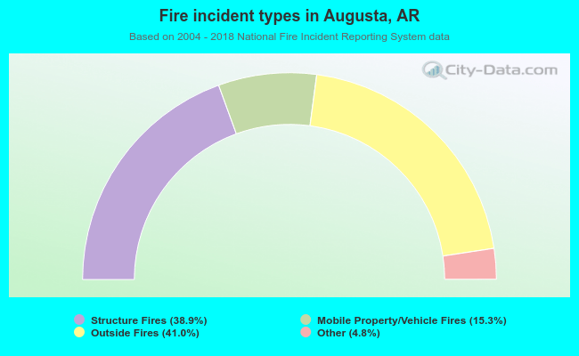 When looking into fire subcategories, the most reports belonged to: Outside Fires (41.0%), and Structure Fires (38.9%).
| Most common first names in Augusta, AR among deceased individuals | ||
| Name | Count | Lived (average) |
|---|---|---|
| James | 53 | 71.9 years |
| John | 44 | 74.7 years |
| Mary | 36 | 77.8 years |
| William | 33 | 73.0 years |
| Robert | 24 | 72.9 years |
| Willie | 22 | 76.9 years |
| Charles | 15 | 68.9 years |
| George | 14 | 75.4 years |
| Annie | 14 | 77.2 years |
| Henry | 12 | 79.2 years |
| Most common last names in Augusta, AR among deceased individuals | ||
| Last name | Count | Lived (average) |
|---|---|---|
| Brown | 39 | 74.0 years |
| Davis | 26 | 76.1 years |
| Jones | 19 | 77.8 years |
| Peebles | 16 | 78.8 years |
| Smith | 15 | 68.2 years |
| Williams | 15 | 84.1 years |
| Miller | 15 | 80.9 years |
| Jackson | 14 | 67.1 years |
| White | 14 | 73.4 years |
| Green | 13 | 73.5 years |
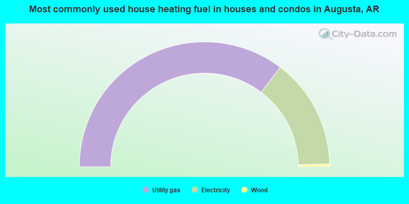
- 70.6%Utility gas
- 28.6%Electricity
- 0.7%Wood
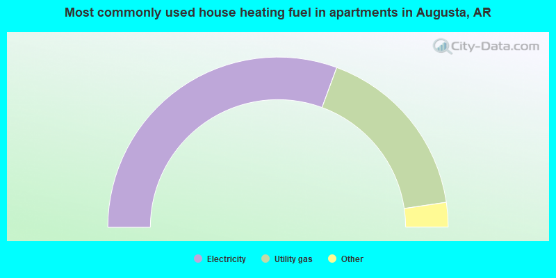
- 61.4%Electricity
- 34.2%Utility gas
- 2.9%No fuel used
- 1.5%Bottled, tank, or LP gas
Augusta compared to Arkansas state average:
- Black race population percentage above state average.
- Hispanic race population percentage significantly below state average.
- Median age above state average.
- Foreign-born population percentage significantly below state average.
- Length of stay since moving in significantly above state average.
- Percentage of population with a bachelor's degree or higher below state average.

|
Total of 5 patent applications in 2008-2024.