Baldwin, Maine
Submit your own pictures of this town and show them to the world
- OSM Map
- Google Map
- MSN Map
Population change since 2000: +18.2%
 |
| Males: 747 | |
| Females: 778 |
| Median resident age: | 42.4 years |
| Maine median age: | 43.0 years |
Zip codes: 04024.
| Baldwin: | $74,035 |
| ME: | $69,543 |
Estimated per capita income in 2022: $36,076 (it was $15,689 in 2000)
Baldwin town income, earnings, and wages data
Estimated median house or condo value in 2022: $314,176 (it was $92,200 in 2000)
| Baldwin: | $314,176 |
| ME: | $290,600 |
Mean prices in 2022: all housing units: $514,200; detached houses: $533,395; townhouses or other attached units: $572,947; in 2-unit structures: $538,406; in 3-to-4-unit structures: $462,507; in 5-or-more-unit structures: $450,834; mobile homes: $93,551
Detailed information about poverty and poor residents in Baldwin, ME
Compare current foreclosures near Baldwin, ME:
| Photo | Address | Area | Beds / Baths | Price | Details |
|---|---|---|---|---|---|

|
#1
Cram Rd
East Baldwin, ME 04024
|
982 sq. feet
|
1 baths 2 beds |
show details | |

|
#2
Line Rd
Gorham, ME 04038
|
1,086 sq. feet
|
1 baths 3 beds |
show details | |

|
#3
High St
Windham, ME 04062
|
933 sq. feet
|
1 baths 2 beds |
show details | |

|
#4
Motorcycle Dr
Windham, ME 04062
|
2,772 sq. feet
|
2 baths 3 beds |
show details | |

|
#5
Windham Center Rd
Windham, ME 04062
|
1,576 sq. feet
|
1 baths 3 beds |
show details | |

|
#6
Majestic Hts
Windham, ME 04062
|
1,668 sq. feet
|
2 baths 3 beds |
show details | |

|
#7
Running Brook Rd
Windham, ME 04062
|
1,749 sq. feet
|
2 baths 3 beds |
show details | |

|
#8
Goldie Ln
Standish, ME 04084
|
2,273 sq. feet
|
1 baths 3 beds |
show details | |

|
#9
Emerson Dr
Windham, ME 04062
|
1,080 sq. feet
|
1 baths 3 beds |
show details | |

|
#10
Jennifer Way
Gorham, ME 04038
|
1,414 sq. feet
|
1 baths 3 beds |
show details |
| Photo | Address | Area | Beds / Baths | Price | Details |
|---|---|---|---|---|---|

|
#11
Ring Landing Rd
Casco, ME 04015
|
1,296 sq. feet
|
1 baths 3 beds |
show details | |

|
#12
Emma Ln
Gorham, ME 04038
|
- sq. feet
|
- baths - beds |
show details | |

|
#13
Webster Rd
Buxton, ME 04093
|
- sq. feet
|
- baths - beds |
show details | |

|
#14
Smith Ave # 1
Bridgton, ME 04009
|
- sq. feet
|
- baths - beds |
show details | |

|
#15
Cape Rd
Limington, ME 04049
|
- sq. feet
|
- baths - beds |
show details | |

|
#16
Sokokis Ave
Limington, ME 04049
|
- sq. feet
|
- baths - beds |
show details | |

|
#17
Sebago Rd
Sebago, ME 04029
|
- sq. feet
|
- baths - beds |
show details | |

|
#18
New Dam Rd
North Waterboro, ME 04061
|
- sq. feet
|
- baths - beds |
show details | |

|
#19
Denmark Rd
Denmark, ME 04022
|
- sq. feet
|
- baths - beds |
show details | |

|
#20
Lattimer Rd
Gray, ME 04039
|
- sq. feet
|
- baths - beds |
show details |
| Photo | Address | Area | Beds / Baths | Price | Details |
|---|---|---|---|---|---|

|
#21
Harlan Dr
Limington, ME 04049
|
- sq. feet
|
- baths - beds |
show details | |

|
Check over 1 million property listings on Foreclosure.com!
|
browse all offers | |||

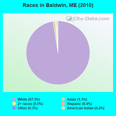
- 1,48797.5%White alone
- 171.1%Asian alone
- 70.5%Two or more races
- 60.4%Hispanic
- 40.3%Other race alone
- 30.2%American Indian alone
- 10.07%Black alone
Races in Baldwin detailed stats: ancestries, foreign born residents, place of birth
According to our research of Maine and other state lists, there were 2 registered sex offenders living in Baldwin, Maine as of April 25, 2024.
The ratio of all residents to sex offenders in Baldwin is 763 to 1.
The ratio of registered sex offenders to all residents in this city is lower than the state average.
 Recent articles from our blog. Our writers, many of them Ph.D. graduates or candidates, create easy-to-read articles on a wide variety of topics.

Ancestries: English (28.6%), French (15.4%), Irish (10.7%), United States (10.3%), German (8.9%), French Canadian (7.6%).
Current Local Time: EST time zone
Incorporated on 06/23/1802
Land area: 35.3 square miles.
Population density: 43 people per square mile (very low).
7 residents are foreign born
| This town: | 0.5% |
| Maine: | 2.9% |
| Baldwin town: | 1.1% ($1,037) |
| Maine: | 1.5% ($1,417) |
Nearest city with pop. 50,000+: Portland, ME  (25.2 miles , pop. 64,249).
Nearest city with pop. 200,000+: Boston, MA (105.5 miles , pop. 589,141).
Nearest city with pop. 1,000,000+: Bronx, NY (261.3 miles , pop. 1,332,650).
Nearest cities:
), ), Latitude: 43.82 N, Longitude: 70.72 W
Area code commonly used in this area: 207
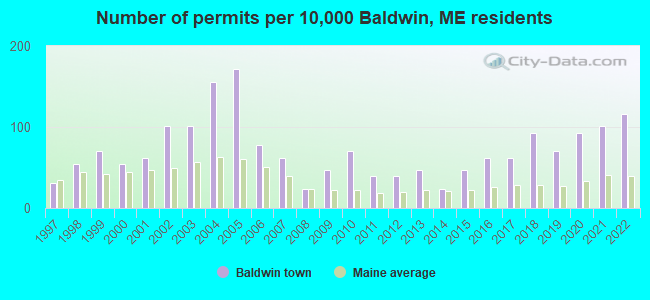
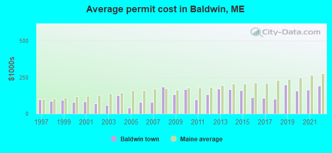
Single-family new house construction building permits:
- 2022: 15 buildings, average cost: $194,300
- 2021: 13 buildings, average cost: $165,800
- 2020: 12 buildings, average cost: $158,800
- 2019: 9 buildings, average cost: $199,900
- 2018: 12 buildings, average cost: $103,100
- 2017: 8 buildings, average cost: $107,800
- 2016: 8 buildings, average cost: $110,600
- 2015: 6 buildings, average cost: $160,800
- 2014: 3 buildings, average cost: $169,300
- 2013: 6 buildings, average cost: $170,800
- 2012: 5 buildings, average cost: $135,200
- 2011: 5 buildings, average cost: $99,000
- 2010: 9 buildings, average cost: $170,300
- 2009: 6 buildings, average cost: $133,300
- 2008: 3 buildings, average cost: $185,000
- 2007: 8 buildings, average cost: $80,000
- 2006: 10 buildings, average cost: $80,000
- 2005: 22 buildings, average cost: $40,900
- 2004: 20 buildings, average cost: $125,000
- 2003: 13 buildings, average cost: $60,800
- 2002: 13 buildings, average cost: $69,200
- 2001: 8 buildings, average cost: $82,600
- 2000: 7 buildings, average cost: $81,700
- 1999: 9 buildings, average cost: $93,100
- 1998: 7 buildings, average cost: $87,100
- 1997: 4 buildings, average cost: $97,000
| Here: | 2.6% |
| Maine: | 3.4% |
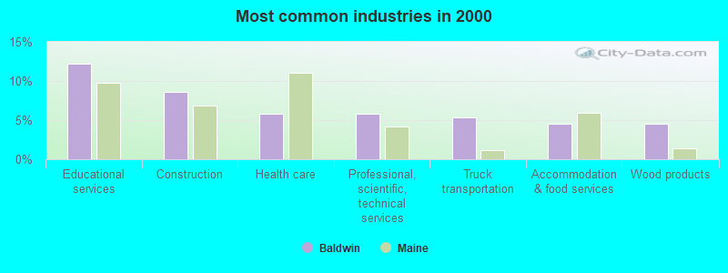
- Educational services (12.2%)
- Construction (8.6%)
- Health care (5.9%)
- Professional, scientific, technical services (5.9%)
- Truck transportation (5.4%)
- Accommodation & food services (4.5%)
- Wood products (4.5%)
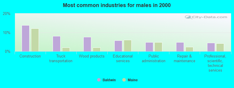
- Construction (13.9%)
- Truck transportation (8.1%)
- Wood products (7.5%)
- Educational services (5.7%)
- Public administration (4.8%)
- Repair & maintenance (4.8%)
- Professional, scientific, technical services (4.5%)
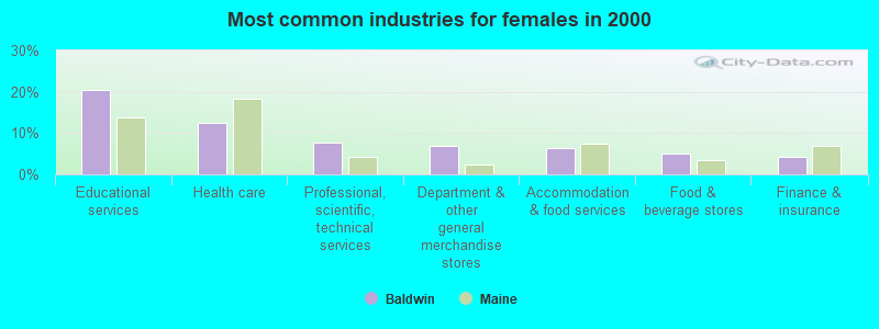
- Educational services (20.5%)
- Health care (12.5%)
- Professional, scientific, technical services (7.6%)
- Department & other general merchandise stores (6.8%)
- Accommodation & food services (6.4%)
- Food & beverage stores (4.9%)
- Finance & insurance (4.2%)
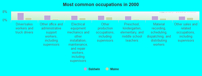
- Driver/sales workers and truck drivers (7.0%)
- Other office and administrative support workers, including supervisors (4.5%)
- Electrical equipment mechanics and other installation, maintenance, and repair workers, including supervisors (4.4%)
- Other production occupations, including supervisors (4.4%)
- Preschool, kindergarten, elementary, and middle school teachers (3.9%)
- Material recording, scheduling, dispatching, and distributing workers (3.9%)
- Other sales and related occupations, including supervisors (3.7%)
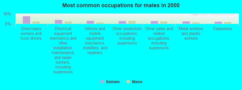
- Driver/sales workers and truck drivers (12.7%)
- Electrical equipment mechanics and other installation, maintenance, and repair workers, including supervisors (6.6%)
- Vehicle and mobile equipment mechanics, installers, and repairers (5.4%)
- Other production occupations, including supervisors (4.8%)
- Other sales and related occupations, including supervisors (4.8%)
- Metal workers and plastic workers (4.5%)
- Carpenters (3.9%)

- Preschool, kindergarten, elementary, and middle school teachers (6.8%)
- Other office and administrative support workers, including supervisors (6.1%)
- Bookkeeping, accounting, and auditing clerks (4.9%)
- Material recording, scheduling, dispatching, and distributing workers (4.5%)
- Health technologists and technicians (4.2%)
- Other management occupations, except farmers and farm managers (4.2%)
- Food and beverage serving workers, except waiters and waitresses (4.2%)
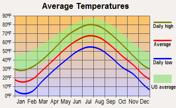
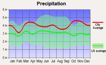
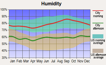
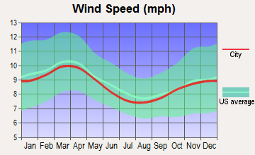
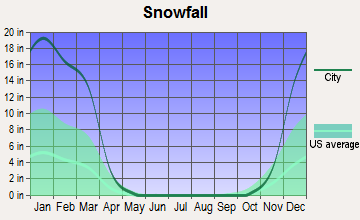
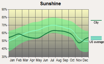
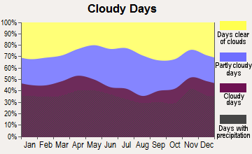
Average climate in Baldwin, Maine
Based on data reported by over 4,000 weather stations
(lower is better)
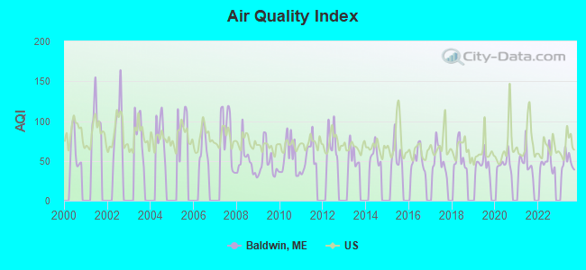
Air Quality Index (AQI) level in 2023 was 48.8. This is significantly better than average.
| City: | 48.8 |
| U.S.: | 72.6 |
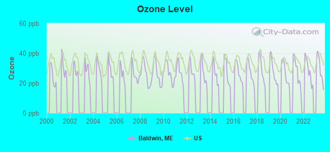
Ozone [ppb] level in 2023 was 29.7. This is about average. Closest monitor was 12.5 miles away from the city center.
| City: | 29.7 |
| U.S.: | 33.3 |
Tornado activity:
Baldwin-area historical tornado activity is above Maine state average. It is 74% smaller than the overall U.S. average.
On 10/10/1966, a category F2 (max. wind speeds 113-157 mph) tornado 27.4 miles away from the Baldwin town center caused between $5000 and $50,000 in damages.
On 7/18/1963, a category F2 tornado 28.4 miles away from the town center caused between $5000 and $50,000 in damages.
Earthquake activity:
Baldwin-area historical earthquake activity is significantly above Maine state average. It is 74% smaller than the overall U.S. average.On 10/16/2012 at 23:12:25, a magnitude 4.7 (4.7 ML, Depth: 10.0 mi, Class: Light, Intensity: IV - V) earthquake occurred 16.0 miles away from the city center
On 4/20/2002 at 10:50:47, a magnitude 5.3 (5.3 ML, Depth: 3.0 mi, Class: Moderate, Intensity: VI - VII) earthquake occurred 155.0 miles away from Baldwin center
On 4/20/2002 at 10:50:47, a magnitude 5.2 (5.2 MB, 4.2 MS, 5.2 MW, 5.0 MW) earthquake occurred 155.5 miles away from the city center
On 1/19/1982 at 00:14:42, a magnitude 4.7 (4.5 MB, 4.7 MD, 4.5 LG) earthquake occurred 49.2 miles away from the city center
On 10/7/1983 at 10:18:46, a magnitude 5.3 (5.1 MB, 5.3 LG, 5.1 ML) earthquake occurred 180.6 miles away from Baldwin center
On 8/21/1996 at 07:54:14, a magnitude 3.8 (3.8 LG, 3.6 LG, Depth: 6.2 mi, Class: Light, Intensity: II - III) earthquake occurred 40.0 miles away from the city center
Magnitude types: regional Lg-wave magnitude (LG), body-wave magnitude (MB), duration magnitude (MD), local magnitude (ML), surface-wave magnitude (MS), moment magnitude (MW)
Natural disasters:
The number of natural disasters in Cumberland County (33) is a lot greater than the US average (15).Major Disasters (Presidential) Declared: 22
Emergencies Declared: 10
Causes of natural disasters: Floods: 19, Storms: 13, Snows: 7, Winter Storms: 6, Heavy Rains: 3, Hurricanes: 3, Winds: 3, Blizzard: 1, Ice Storm: 1, Mudslide: 1, Snowfall: 1, Snowstorm: 1, Tornado: 1, Other: 2 (Note: some incidents may be assigned to more than one category).
Colleges/universities with over 2000 students nearest to Baldwin:
- Saint Joseph's College of Maine (about 13 miles; Standish, ME; Full-time enrollment: 2,010)
- University of Southern Maine (about 25 miles; Portland, ME; FT enrollment: 6,647)
- Southern Maine Community College (about 28 miles; South Portland, ME; FT enrollment: 4,666)
- University of New England (about 31 miles; Biddeford, ME; FT enrollment: 4,539)
- Plymouth State University (about 49 miles; Plymouth, NH; FT enrollment: 4,838)
- University of New Hampshire-Main Campus (about 49 miles; Durham, NH; FT enrollment: 15,243)
- NHTI-Concord's Community College (about 58 miles; Concord, NH; FT enrollment: 2,865)
Public elementary/middle school in Baldwin:
- BALDWIN CONSOLIDATED SCHOOL (Students: 136, Location: 536 PEQUAWKET TRAIL, Grades: KG-4)
Points of interest:
Notable locations in Baldwin: Cornish Station (A), East Baldwin Fire Station (B), West Baldwin Fire Station (C), North Baldwin Fire Station (D). Display/hide their locations on the map
Cemeteries: Emerson-Thorne Cemetery (1), Dyer Cemetery (2), Flint Cemetery (3), Weeman Cemetery (4), Benton Cemetery (5), Larrabee Cemetery (6), Goodwin Cemetery (7). Display/hide their locations on the map
Lakes and reservoirs: Halfmoon Pond (A), Rainbow Pond (B), Ingalls Pond (C), Sand Pond (D), Southeast Pond (E), Upper Pond (F), Woods Millpond (G), Sanborn Pond (H). Display/hide their locations on the map
Streams, rivers, and creeks: Quaker Brook (A), Dug Hill Brook (B), Pigeon Brook (C), Breakneck Brook (D). Display/hide their locations on the map
Birthplace of: Cannonball Titcomb - Major League Baseball player, Josiah Pierce - Politician.
| This town: | 2.6 people |
| Maine: | 2.3 people |
| This town: | 73.3% |
| Whole state: | 62.9% |
| This town: | 8.3% |
| Whole state: | 9.4% |
Likely homosexual households (counted as self-reported same-sex unmarried-partner households)
- Lesbian couples: 0.3% of all households
- Gay men: 0.0% of all households
| This town: | 11.2% |
| Whole state: | 10.9% |
| This town: | 2.8% |
| Whole state: | 4.1% |
For population 15 years and over in Baldwin:
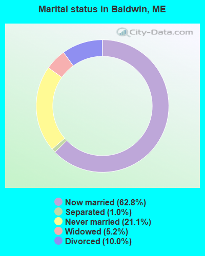
- Never married: 21.1%
- Now married: 62.8%
- Separated: 1.0%
- Widowed: 5.2%
- Divorced: 10.0%
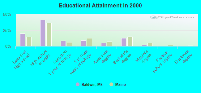
For population 25 years and over in Baldwin:
- High school or higher: 80.2%
- Bachelor's degree or higher: 15.9%
- Graduate or professional degree: 3.1%
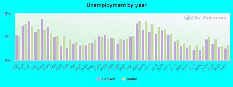
- Unemployed: 6.9%
- Mean travel time to work (commute): 35.6 minutes
| Here: | 10.3 |
| Maine average: | 11.2 |
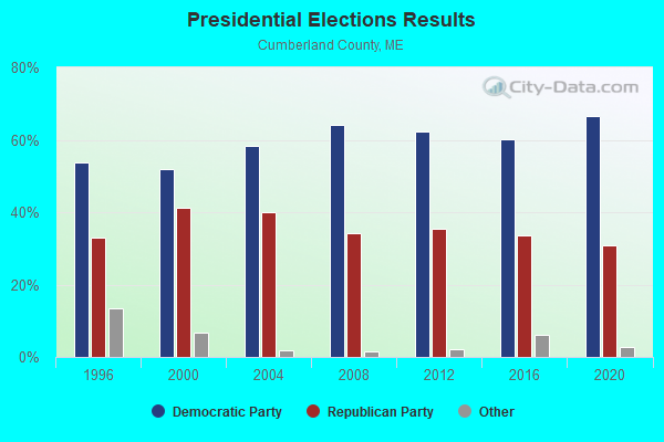
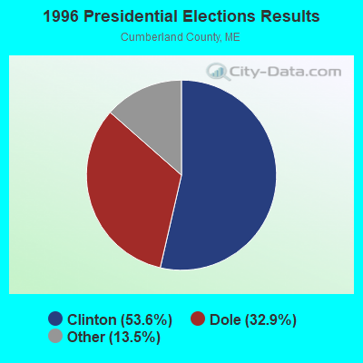
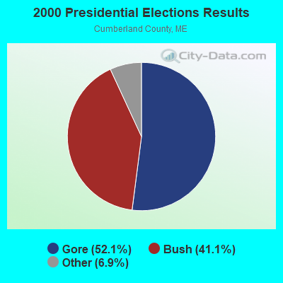
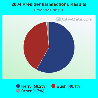
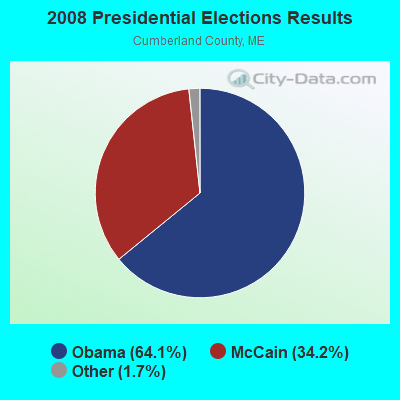
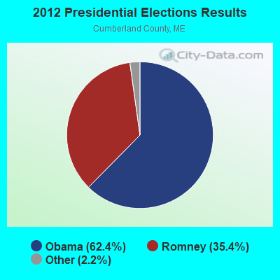
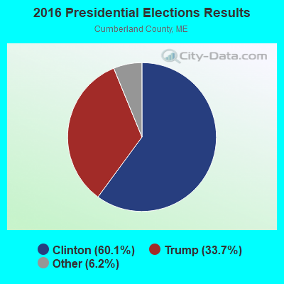
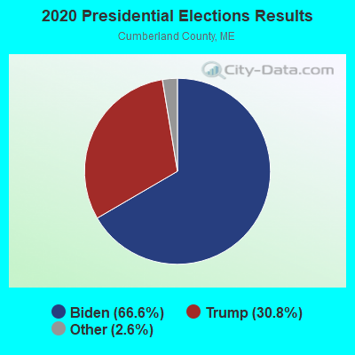
Graphs represent county-level data. Detailed 2008 Election Results
Religion statistics for Baldwin, ME (based on Cumberland County data)
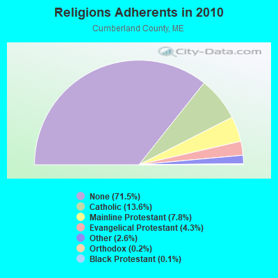
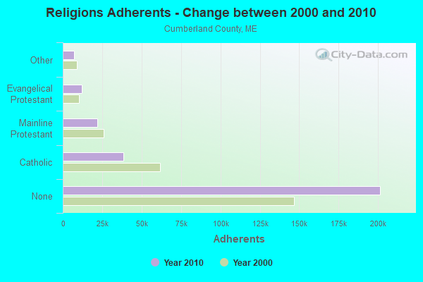
| Religion | Adherents | Congregations |
|---|---|---|
| Catholic | 38,243 | 19 |
| Mainline Protestant | 22,030 | 96 |
| Evangelical Protestant | 12,007 | 85 |
| Other | 7,187 | 44 |
| Orthodox | 500 | 1 |
| Black Protestant | 285 | 2 |
| None | 201,422 | - |
Food Environment Statistics:
| Cumberland County: | 2.62 / 10,000 pop. |
| Maine: | 2.80 / 10,000 pop. |
| This county: | 0.11 / 10,000 pop. |
| State: | 0.14 / 10,000 pop. |
| Cumberland County: | 2.44 / 10,000 pop. |
| Maine: | 2.20 / 10,000 pop. |
| Cumberland County: | 3.82 / 10,000 pop. |
| State: | 5.75 / 10,000 pop. |
| Here: | 12.01 / 10,000 pop. |
| State: | 11.02 / 10,000 pop. |
| This county: | 7.1% |
| Maine: | 8.2% |
| Cumberland County: | 19.5% |
| Maine: | 25.0% |
Strongest AM radio stations in Baldwin:
- WMTW (870 AM; 10 kW; GORHAM, ME; Owner: RADIO PARTNERS OF MAINE, L.P.)
- WGAN (560 AM; 5 kW; PORTLAND, ME; Owner: SAGA COMMUNICATIONS OF NEW ENGLAND, LLC)
- WJAE (1440 AM; 5 kW; WESTBROOK, ME; Owner: ALTANTIC COAST RADIO, LLC)
- WLOB (1310 AM; 5 kW; PORTLAND, ME; Owner: ATLANTIC COAST RADIO, LLC)
- WZAN (970 AM; 5 kW; PORTLAND, ME; Owner: SAGA COMMUNICATIONS OF NEW ENGLAND, LLC)
- WRKO (680 AM; 50 kW; BOSTON, MA; Owner: ENTERCOM BOSTON LICENSE, LLC)
- WGIN (930 AM; 10 kW; ROCHESTER, NH; Owner: CAPSTAR TX LIMITED PARTNERSHIP)
- WTME (780 AM; 10 kW; RUMFORD, ME; Owner: MOUNTAIN VALLEY BROADCASTING, INC.)
- WEEI (850 AM; 50 kW; BOSTON, MA; Owner: ENTERCOM BOSTON LICENSE, LLC)
- WBZ (1030 AM; 50 kW; BOSTON, MA; Owner: INFINITY BROADCASTING OPERATIONS, INC.)
- WLAM (1470 AM; 5 kW; LEWISTON, ME; Owner: RADIO PARTNERS OF MAINE, L.P.)
- WASR (1420 AM; 5 kW; WOLFEBORO, NH; Owner: RADIO WOLFEBORO, INC.)
- WCRN (830 AM; 50 kW; WORCESTER, MA; Owner: CARTER BROADCASTING CORPORATION)
Strongest FM radio stations in Baldwin:
- WMEA (90.1 FM; PORTLAND, ME; Owner: MAINE PUBLIC BROADCASTING CORPORATION)
- WBLM (102.9 FM; PORTLAND, ME; Owner: CITADEL BROADCASTING COMPANY)
- WPKQ (103.7 FM; NORTH CONWAY, NH; Owner: CITADEL BROADCASTING COMPANY)
- WHOM (94.9 FM; MT. WASHINGTON, NH; Owner: CITADEL BROADCASTING COMPANY)
- WSCY (106.9 FM; MOULTONBOROUGH, NH; Owner: NORTHEAST COMMUNICATIONS CORPORATION)
- WJBQ (97.9 FM; PORTLAND, ME; Owner: CITADEL BROADCASTING COMPANY)
- WTHT (107.5 FM; LEWISTON, ME; Owner: RADIO PARTNERS OF MAINE, L.P.)
- WVFM (105.7 FM; CAMPTON, NH; Owner: DEVON BROADCASTING COMPANY, INC.)
- WMTW-FM (106.7 FM; NORTH WINDHAM, ME; Owner: RADIO PARTNERS OF MAINE, L.P.)
- WPOR (101.9 FM; PORTLAND, ME; Owner: SAGA COMMUNICATIONS OF NEW ENGLAND, LLC)
- WMEK-FM (99.9 FM; AUBURN, ME; Owner: RADIO PARTNERS OF MAINE, L.P.)
- WMSJ (89.3 FM; FREEPORT, ME; Owner: DOWNEAST CHRISTIAN COMMUNICATIONS)
- WLKZ (104.9 FM; WOLFEBORO, NH; Owner: TELE-MEDIA COMPANY OF NEW HAMPSHIRE, L.L.C.)
- WLOB-FM (96.3 FM; RUMFORD, ME; Owner: ATLANTIC COAST RADIO, LLC)
- WPHX-FM (92.1 FM; SANFORD, ME; Owner: FNX BROADCASTING LLC)
- WSEW (88.5 FM; SANFORD, ME; Owner: WORD RADIO EDUCATIONAL FOUNDATION)
- WVMJ (104.5 FM; CONWAY, NH; Owner: MT. WASHINGTON RADIO & GRAMOPHONE, L.L.C.)
- WMWV (93.5 FM; CONWAY, NH; Owner: MT. WASHINGTON RADIO & GRAMOPHONE, L.L.C.)
- WCYY (94.3 FM; BIDDEFORD, ME; Owner: CITADEL BROADCASTING COMPANY)
- WMEX (106.5 FM; FARMINGTON, NH; Owner: WIMMEX, LLC)
TV broadcast stations around Baldwin:
- WMTW-TV (Channel 8; POLAND SPRING, ME; Owner: WMTW BROADCAST GROUP, LLC)
- WCSH (Channel 6; PORTLAND, ME; Owner: PACIFIC AND SOUTHERN COMPANY, INC.)
- WGME-TV (Channel 13; PORTLAND, ME; Owner: WGME LICENSEE, LLC)
- WMEA-TV (Channel 26; BIDDEFORD, ME; Owner: MAINE PUBLIC BROADCASTING CORP.)
- WPXT (Channel 51; PORTLAND, ME; Owner: HMW, INC.)
- WPME (Channel 35; LEWISTON, ME; Owner: KB PRIME MEDIA LLC)
- W32CA (Channel 32; PORTLAND, ME; Owner: NATIONAL MINORITY T.V., INC.)
- W58CM (Channel 58; BANGOR, ME; Owner: MS COMMUNICATIONS, LLC)
Baldwin fatal accident list:
Jun 11, 2018 11:26 AM, Sr-11 Pequawket Trl, Lat: 43.799411, Lon: -70.671189, Vehicles: 3, Persons: 5, Fatalities: 1
Jun 11, 2017 02:23 AM, Sr-11 Sebago Rd, Lat: 43.834031, Lon: -70.667661, Vehicles: 1, Persons: 1, Fatalities: 1, Drunk persons involved: 1
Jun 12, 2012 09:35 PM, Pigeon Brook Road, Lat: 43.802717, Lon: -70.732947, Vehicles: 1, Persons: 1, Fatalities: 1, Drunk persons involved: 1
Oct 8, 2007 01:11 PM, Rocky Dunn Road, Lat: 43.810764, Lon: -70.760483, Vehicles: 2, Persons: 2, Fatalities: 1, Drunk persons involved: 1
Mar 9, 2006 10:00 AM, Cram Hill Road, Lat: 43.842300, Lon: -70.680980, Vehicles: 1, Persons: 1, Fatalities: 1
- National Bridge Inventory (NBI) Statistics
- 5Number of bridges
- 13ft / 3.8mTotal length
- 14,631Total average daily traffic
- 730Total average daily truck traffic
- 20,612Total future (year 2036) average daily traffic
FCC Registered Cell Phone Towers:
2 (See the full list of FCC Registered Cell Phone Towers in Baldwin)FCC Registered Antenna Towers:
15 (See the full list of FCC Registered Antenna Towers)FCC Registered Broadcast Land Mobile Towers:
1- Rt 113 Baldwin School (Lat: 43.804250 Lon: -70.716167), Call Sign: KNBN570,
Assigned Frequencies: 45.1200 MHz, Grant Date: 08/09/1996, Expiration Date: 09/24/2001, Cancellation Date: 02/24/2002, Registrant: Baldwin, Town Of, Rfd Box 51, West Baldwin, ME 04091, Phone: (207) 625-3580
FCC Registered Microwave Towers:
3- Baldwin Tower, Western Peak Of Bald Mountain (Lat: 43.845556 Lon: -70.761389), Type: Tower, Structure height: 474 m, Overall height: 508 m, Call Sign: WPYC579,
Assigned Frequencies: 6887.50 MHz, Grant Date: 07/18/2003, Expiration Date: 04/01/2023, Cancellation Date: 04/14/2022, Certifier: David Kaufman, Registrant: Brooks, Pierce Et Al., Raleigh, NC 27602, Phone: (919) 839-0300, Fax: (919) 839-0304, Email:
- Baldwin Tower, Western Peak Of Bald Mountain (Lat: 43.845556 Lon: -70.761389), Type: Gtower, Structure height: 182.9 m, Overall height: 508 m, Call Sign: WPYC583,
Assigned Frequencies: 6962.50 MHz, Grant Date: 07/18/2003, Expiration Date: 04/01/2031, Certifier: David Kaufman, Registrant: Brooks, Pierce Et Al., 150 Fayetteville Street, Suite 1700, Raleigh, NC 27601, Phone: (919) 839-0300, Fax: (919) 839-0304, Email:
- BALDWIN WMTW, Western Peak Of Bald Mountain (Lat: 43.845556 Lon: -70.761389), Type: Gtower, Structure height: 474 m, Overall height: 508 m, Call Sign: WRHS884,
Assigned Frequencies: 11405.0 MHz, 11405.0 MHz, 11405.0 MHz, 11405.0 MHz, 11405.0 MHz, Grant Date: 06/10/2020, Expiration Date: 06/10/2030, Certifier: William Holmes, Registrant: Radio Communications Management Inc., 158 Rand Road, Rcm, Portland, ME 04102, Phone: (207) 797-7503, Email:
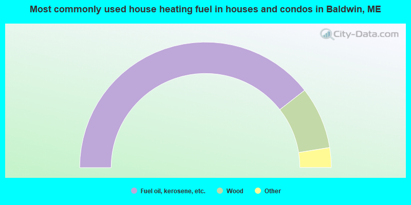
- 78.9%Fuel oil, kerosene, etc.
- 16.0%Wood
- 3.9%Bottled, tank, or LP gas
- 1.2%Electricity
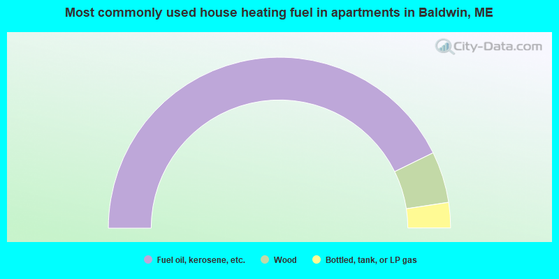
- 85.5%Fuel oil, kerosene, etc.
- 9.7%Wood
- 4.8%Bottled, tank, or LP gas
Baldwin compared to Maine state average:
- Unemployed percentage below state average.
- Black race population percentage significantly below state average.
- Hispanic race population percentage significantly below state average.
- Foreign-born population percentage significantly below state average.
- Renting percentage below state average.
- Length of stay since moving in significantly above state average.
- Number of rooms per house significantly below state average.
- House age significantly below state average.
- Percentage of population with a bachelor's degree or higher below state average.