Corryton, Tennessee
Submit your own pictures of this place and show them to the world
- OSM Map
- General Map
- Google Map
- MSN Map

| Males: 1,145 | |
| Females: 1,204 |
| Median resident age: | 39.4 years |
| Tennessee median age: | 35.9 years |
Zip code: 37721
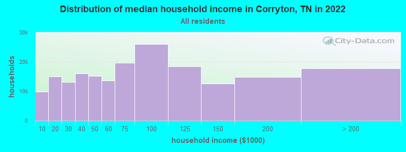
| Corryton: | $66,872 |
| TN: | $65,254 |
Estimated per capita income in 2022: $39,058 (it was $21,192 in 2000)
Corryton CCD income, earnings, and wages data
Estimated median house or condo value in 2022: $293,273 (it was $91,900 in 2000)
| Corryton: | $293,273 |
| TN: | $284,800 |
Mean prices in 2022: all housing units: $359,911; detached houses: $378,570; townhouses or other attached units: $302,801; in 2-unit structures: $187,496; in 3-to-4-unit structures: $174,348; in 5-or-more-unit structures: $303,260; mobile homes: $93,622; occupied boats, rvs, vans, etc.: $148,834
Detailed information about poverty and poor residents in Corryton, TN

Compare current foreclosures near Corryton, TN:
| Photo | Address | Area | Beds / Baths | Price | Details |
|---|---|---|---|---|---|

|
#1
Roberts Rd
Corryton, TN 37721
|
1,508 sq. feet
|
2 baths 3 beds |
show details | |

|
#2
Country Rose Ln
Corryton, TN 37721
|
2,010 sq. feet
|
2 baths 3 beds |
show details | |

|
#3
Glorious Ln
Corryton, TN 37721
|
1,499 sq. feet
|
2 baths 3 beds |
show details | |

|
#4
Pisa Cir
Corryton, TN 37721
|
1,370 sq. feet
|
2 baths 3 beds |
show details | |

|
#5
Dunsmore Ln
Corryton, TN 37721
|
1,421 sq. feet
|
1 baths 3 beds |
show details | |

|
#6
Ridgeview Rd
Corryton, TN 37721
|
1,491 sq. feet
|
1 baths 4 beds |
show details | |

|
#7
Farmhouse View Ln
Corryton, TN 37721
|
- sq. feet
|
- baths - beds |
show details | |

|
#8
Cataba Ln
Corryton, TN 37721
|
980 sq. feet
|
- baths - beds |
show details | |

|
#9
Cardwell Rd
Corryton, TN 37721
|
1,920 sq. feet
|
- baths - beds |
show details | |

|
#10
Corryton Rd Lot 20
Corryton, TN 37721
|
- sq. feet
|
- baths - beds |
show details |
| Photo | Address | Area | Beds / Baths | Price | Details |
|---|---|---|---|---|---|

|
#11
Forest Willow Ln
Corryton, TN 37721
|
- sq. feet
|
- baths - beds |
show details | |

|
#12
3rd St
Corryton, TN 37721
|
1,568 sq. feet
|
- baths - beds |
show details | |

|
#13
Maloneyville Rd
Corryton, TN 37721
|
- sq. feet
|
- baths - beds |
show details | |

|
#14
Highway 131
Washburn, TN 37888
|
1,400 sq. feet
|
2 baths 3 beds |
$335,000
|
show details |

|
#15
Patterson Town Rd
Blaine, TN 37709
|
1,026 sq. feet
|
1 baths - beds |
$24,900
|
show details |

|
#16
Daniels Rd
Knoxville, TN 37938
|
2,356 sq. feet
|
2 baths 3 beds |
show details | |

|
#17
Lyle Rd
Dandridge, TN 37725
|
1,428 sq. feet
|
3 baths 2 beds |
show details | |

|
#18
Edgewood Ave
Knoxville, TN 37917
|
1,560 sq. feet
|
2 baths 3 beds |
show details | |

|
#19
Green Pasture Dr
Knoxville, TN 37924
|
2,698 sq. feet
|
1 baths 4 beds |
show details | |

|
#20
Possum Valley Rd
Maynardville, TN 37807
|
1,960 sq. feet
|
3 baths 3 beds |
show details |
| Photo | Address | Area | Beds / Baths | Price | Details |
|---|---|---|---|---|---|

|
#21
Valley View Dr
Knoxville, TN 37917
|
1,658 sq. feet
|
2 baths 3 beds |
show details | |

|
#22
Peltier Rd
Knoxville, TN 37912
|
1,388 sq. feet
|
2 baths 4 beds |
show details | |

|
#23
Pelleaux Rd
Knoxville, TN 37938
|
- sq. feet
|
1 baths 3 beds |
show details | |

|
#24
Timberlane Cir
Knoxville, TN 37924
|
2,253 sq. feet
|
3 baths 4 beds |
show details | |

|
#25
Jesse Baker Ln
Jefferson City, TN 37760
|
- sq. feet
|
2 baths 4 beds |
show details | |

|
#26
Andes St
Knoxville, TN 37914
|
2,088 sq. feet
|
1 baths 2 beds |
show details | |

|
#27
Wallace Dr
Andersonville, TN 37705
|
1,454 sq. feet
|
1 baths 3 beds |
show details | |

|
#28
Dexter Ln
Knoxville, TN 37920
|
950 sq. feet
|
1 baths 3 beds |
show details | |

|
#29
Quiet Brook Ln
Knoxville, TN 37914
|
1,800 sq. feet
|
2 baths 3 beds |
show details | |

|
#30
Boyds Bridge Pike
Knoxville, TN 37914
|
1,272 sq. feet
|
1 baths 3 beds |
show details |
| Photo | Address | Area | Beds / Baths | Price | Details |
|---|---|---|---|---|---|

|
#31
Helen Ln
Powell, TN 37849
|
1,500 sq. feet
|
2 baths 3 beds |
show details | |

|
#32
Old Andersonville Pike
Knoxville, TN 37938
|
1,160 sq. feet
|
2 baths 3 beds |
show details | |

|
#33
Spring Valley Dr
Knoxville, TN 37917
|
1,485 sq. feet
|
2 baths 3 beds |
show details | |

|
#34
Cedar Ln
Knoxville, TN 37918
|
1,450 sq. feet
|
1 baths 3 beds |
show details | |

|
#35
Ross Mccloud Way
Knoxville, TN 37938
|
1,592 sq. feet
|
2 baths 3 beds |
show details | |

|
#36
Maple View Way
Knoxville, TN 37918
|
1,000 sq. feet
|
2 baths 2 beds |
show details | |

|
#37
Louise Ave
Knoxville, TN 37914
|
1,144 sq. feet
|
1 baths 3 beds |
show details | |

|
#38
Fountain Dr
Knoxville, TN 37918
|
2,406 sq. feet
|
3 baths 3 beds |
show details | |

|
#39
Fountain Park Blvd
Knoxville, TN 37917
|
1,456 sq. feet
|
2 baths 3 beds |
show details | |

|
#40
Strawberry Plains Pike
Knoxville, TN 37914
|
1,384 sq. feet
|
1 baths 2 beds |
show details |
| Photo | Address | Area | Beds / Baths | Price | Details |
|---|---|---|---|---|---|

|
#41
Fairmont Blvd
Knoxville, TN 37917
|
1,180 sq. feet
|
1 baths 2 beds |
show details | |

|
#42
Thorngrove Pike
Knoxville, TN 37914
|
1,359 sq. feet
|
1 baths 2 beds |
show details | |

|
#43
Brunswick St
Knoxville, TN 37917
|
700 sq. feet
|
1 baths 2 beds |
show details | |

|
#44
Woodbine Ave
Knoxville, TN 37914
|
1,140 sq. feet
|
1 baths 2 beds |
show details | |

|
#45
Bernhurst Dr
Knoxville, TN 37918
|
1,024 sq. feet
|
2 baths 3 beds |
show details | |

|
#46
Avondale Ave
Knoxville, TN 37917
|
978 sq. feet
|
1 baths 2 beds |
show details | |

|
#47
Nichols Ave
Knoxville, TN 37917
|
1,316 sq. feet
|
2 baths 4 beds |
show details | |

|
#48
Lay Ave
Knoxville, TN 37914
|
1,247 sq. feet
|
1 baths 2 beds |
show details | |

|
#49
N Apopka Dr
Knoxville, TN 37914
|
1,842 sq. feet
|
2 baths 3 beds |
show details | |

|
Check over 1 million property listings on Foreclosure.com!
|
browse all offers | |||

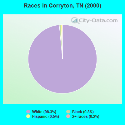
- 2,08498.3%White alone
- 160.8%Black alone
- 110.5%Hispanic
- 50.2%Two or more races
- 20.09%American Indian alone
- 10.05%Other race alone
Races in Corryton detailed stats: ancestries, foreign born residents, place of birth
According to our research of Tennessee and other state lists, there were 23 registered sex offenders living in Corryton, Tennessee as of April 25, 2024.
The ratio of all residents to sex offenders in Corryton is 102 to 1.
 Recent articles from our blog. Our writers, many of them Ph.D. graduates or candidates, create easy-to-read articles on a wide variety of topics.

Current Local Time: EST time zone
Elevation: 1045 feet
Land area: 17.6 square miles.
Population density: 134 people per square mile (very low).

| Corryton CCD: | 0.7% ($643) |
| Tennessee: | 0.8% ($715) |
Nearest city with pop. 50,000+: Knoxville, TN  (15.7 miles , pop. 173,890).
Nearest city with pop. 200,000+: Fayette, KY (136.4 miles , pop. 260,512).
Nearest city with pop. 1,000,000+: Chicago, IL (446.5 miles , pop. 2,896,016).
Nearest cities:
), ), ), ), ), )Latitude: 36.15 N, Longitude: 83.76 W
Area code commonly used in this area: 865

| Here: | 2.6% |
| Tennessee: | 3.0% |
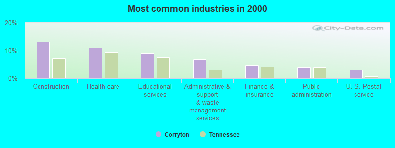
- Construction (13.1%)
- Health care (11.1%)
- Educational services (8.9%)
- Administrative & support & waste management services (6.8%)
- Finance & insurance (4.8%)
- Public administration (4.1%)
- U. S. Postal service (3.2%)
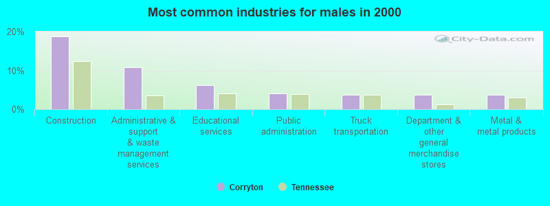
- Construction (18.8%)
- Administrative & support & waste management services (10.7%)
- Educational services (6.2%)
- Public administration (4.1%)
- Truck transportation (3.6%)
- Department & other general merchandise stores (3.6%)
- Metal & metal products (3.6%)
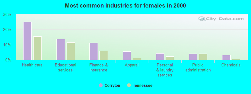
- Health care (25.1%)
- Educational services (13.8%)
- Finance & insurance (11.3%)
- Apparel (5.5%)
- Personal & laundry services (4.4%)
- Public administration (4.1%)
- Chemicals (3.3%)
- Other management occupations, except farmers and farm managers (6.3%)
- Construction traders workers except carpenters, electricians, painters, plumbers, and construction laborers (5.9%)
- Driver/sales workers and truck drivers (5.6%)
- Other production occupations, including supervisors (5.4%)
- Electrical equipment mechanics and other installation, maintenance, and repair workers, including supervisors (4.9%)
- Retail sales workers, except cashiers (4.7%)
- Building and grounds cleaning and maintenance occupations (4.3%)

- Other management occupations, except farmers and farm managers (10.0%)
- Construction traders workers except carpenters, electricians, painters, plumbers, and construction laborers (9.3%)
- Electrical equipment mechanics and other installation, maintenance, and repair workers, including supervisors (7.7%)
- Driver/sales workers and truck drivers (7.6%)
- Building and grounds cleaning and maintenance occupations (6.8%)
- Retail sales workers, except cashiers (6.0%)
- Material recording, scheduling, dispatching, and distributing workers (5.1%)

- Other financial specialists (8.8%)
- Information and record clerks, except customer service representatives (8.0%)
- Personal appearance workers (7.2%)
- Other teachers, instructors, education, training, and library occupations (7.2%)
- Other production occupations, including supervisors (6.4%)
- Secretaries and administrative assistants (6.1%)
- Textile, apparel, and furnishings workers (5.5%)
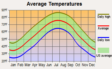
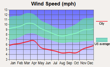
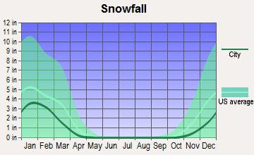
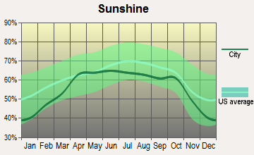
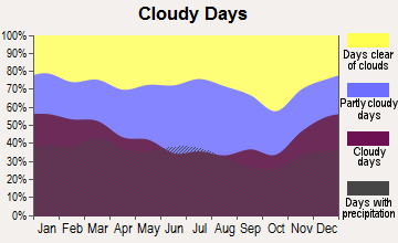
Average climate in Corryton, Tennessee
Based on data reported by over 4,000 weather stations

(lower is better)
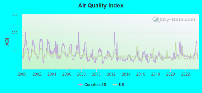
Air Quality Index (AQI) level in 2023 was 89.5. This is worse than average.
| City: | 89.5 |
| U.S.: | 72.6 |
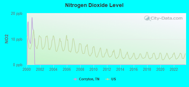
Nitrogen Dioxide (NO2) [ppb] level in 2000 was 12.6. This is significantly worse than average. Closest monitor was 3.0 miles away from the city center.
| City: | 12.6 |
| U.S.: | 5.1 |
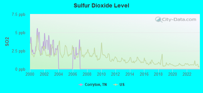
Sulfur Dioxide (SO2) [ppb] level in 2006 was 2.32. This is significantly worse than average. Closest monitor was 3.0 miles away from the city center.
| City: | 2.32 |
| U.S.: | 1.51 |
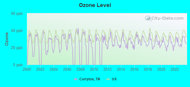
Ozone [ppb] level in 2023 was 28.9. This is about average. Closest monitor was 3.0 miles away from the city center.
| City: | 28.9 |
| U.S.: | 33.3 |
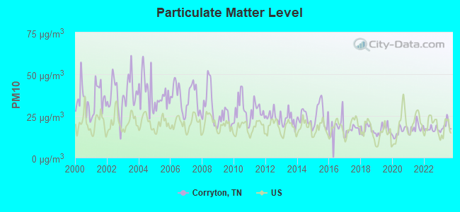
Particulate Matter (PM10) [µg/m3] level in 2023 was 18.9. This is about average. Closest monitor was 5.9 miles away from the city center.
| City: | 18.9 |
| U.S.: | 19.2 |
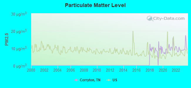
Particulate Matter (PM2.5) [µg/m3] level in 2023 was 10.7. This is worse than average. Closest monitor was 10.8 miles away from the city center.
| City: | 10.7 |
| U.S.: | 8.1 |
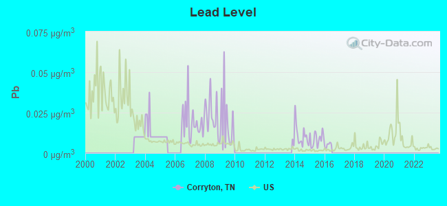
Lead (Pb) [µg/m3] level in 2015 was 0.00868. This is about average. Closest monitor was 10.9 miles away from the city center.
| City: | 0.00868 |
| U.S.: | 0.00931 |
Tornado activity:
Corryton-area historical tornado activity is significantly below Tennessee state average. It is 43% smaller than the overall U.S. average.
On 2/21/1993, a category F3 (max. wind speeds 158-206 mph) tornado 12.1 miles away from the Corryton place center injured 3 people and caused between $500,000 and $5,000,000 in damages.
On 2/21/1993, a category F3 tornado 30.5 miles away from the place center killed one person and injured 55 people and caused between $5000 and $50,000 in damages.
Earthquake activity:
Corryton-area historical earthquake activity is significantly above Tennessee state average. It is 71% greater than the overall U.S. average.On 11/30/1973 at 07:48:41, a magnitude 4.7 (4.7 MB, 4.6 ML, Class: Light, Intensity: IV - V) earthquake occurred 26.5 miles away from the city center
On 7/27/1980 at 18:52:21, a magnitude 5.2 (5.1 MB, 4.7 MS, 5.0 UK, 5.2 UK, Class: Moderate, Intensity: VI - VII) earthquake occurred 142.8 miles away from the city center
On 8/9/2020 at 12:07:37, a magnitude 5.1 (5.1 MW, Depth: 4.7 mi) earthquake occurred 150.4 miles away from Corryton center
On 4/29/2003 at 08:59:39, a magnitude 4.9 (4.4 MB, 4.6 MW, 4.9 LG) earthquake occurred 155.4 miles away from the city center
On 12/12/2018 at 09:14:43, a magnitude 4.4 (4.4 MW, Depth: 4.9 mi) earthquake occurred 65.7 miles away from Corryton center
On 8/23/2011 at 17:51:04, a magnitude 5.8 (5.8 MW, Depth: 3.7 mi) earthquake occurred 343.9 miles away from the city center
Magnitude types: regional Lg-wave magnitude (LG), body-wave magnitude (MB), local magnitude (ML), surface-wave magnitude (MS), moment magnitude (MW)
Natural disasters:
The number of natural disasters in Knox County (13) is near the US average (15).Major Disasters (Presidential) Declared: 8
Emergencies Declared: 2
Causes of natural disasters: Floods: 9, Storms: 7, Tornadoes: 6, Winds: 3, Winter Storms: 2, Heavy Rain: 1, Hurricane: 1, Landslide: 1, Mudslide: 1, Snowfall: 1, Other: 1 (Note: some incidents may be assigned to more than one category).
Hospitals and medical centers near Corryton:
- WARIOTA HLTH CARE CTR (Nursing Home, about 8 miles away; MAYNARDVILLE, TN)
- WILLOW RIDGE CARE AND REHABILITATION CENTER (Nursing Home, about 8 miles away; MAYNARDVILLE, TN)
- ST MARY'S HOSPICE (Hospital, about 11 miles away; KNOXVILLE, TN)
- MERCY HOMECARE SERVICES (Home Health Center, about 11 miles away; KNOXVILLE, TN)
- LIFE CARE CTR OF JEFFERSON CITY (Nursing Home, about 13 miles away; JEFFERSON CITY, TN)
- HOLSTON HEALTH AND REHABILITATION CENTER (Nursing Home, about 13 miles away; KNOXVILLE, TN)
- FMC N KNOXVILLE DIALYSIS CNTR (Dialysis Facility, about 13 miles away; KNOXVILLE, TN)
Colleges/universities with over 2000 students nearest to Corryton:
- The University of Tennessee-Knoxville (about 17 miles; Knoxville, TN; Full-time enrollment: 25,483)
- Pellissippi State Community College (about 27 miles; Knoxville, TN; FT enrollment: 7,271)
- Walters State Community College (about 29 miles; Morristown, TN; FT enrollment: 4,359)
- Lincoln Memorial University (about 31 miles; Harrogate, TN; FT enrollment: 3,706)
- University of the Cumberlands (about 47 miles; Williamsburg, KY; FT enrollment: 3,585)
- Roane State Community College (about 52 miles; Harriman, TN; FT enrollment: 4,302)
- Tusculum College (about 56 miles; Greeneville, TN; FT enrollment: 2,070)
Public high school in Corryton:
- GIBBS HIGH SCHOOL (Students: 1,021, Location: 7628 TAZEWELL PK, Grades: 9-12)
Public elementary/middle schools in Corryton:
- GIBBS ELEMENTARY (Students: 681, Location: 7715 TAZEWELL PK, Grades: KG-5)
- CORRYTON ELEMENTARY (Students: 218, Location: 7200 CORRYTON RD, Grades: KG-5)
Private elementary/middle school in Corryton:
Points of interest:
Notable locations in Corryton: Sternenlit Farms (A), Kimberden Farms (B), Rural / Metro Fire Department Knoxville 33 (C). Display/hide their locations on the map
Churches in Corryton include: Little Flat Creek Church (A), Corryton Baptist Church (B), House Mountain Church (C). Display/hide their locations on the map
Cemeteries: Howell Cemetery (1), Walker Cemetery (2), Zachary Cemetery (3), McBee Cemetery (4), Chamberlain Cemetery (5), Mynatt Cemetery (6), Old Flat Creek Cemetery (7). Display/hide their locations on the map
Streams, rivers, and creeks: Dyer Branch (A), Little Flat Creek (B), Mile Branch (C), Zachary Branch (D). Display/hide their locations on the map
Drinking water stations with addresses in Corryton and their reported violations in the past:
NORTHEAST KNOX U D (Population served: 22,617, Surface water):Past monitoring violations:
- Monitoring and Reporting (DBP) - Between JUL-2008 and SEP-2008, Contaminant: Chlorine. Follow-up actions: St Violation/Reminder Notice (SEP-02-2008), St Public Notif requested (SEP-02-2008), St Compliance achieved (DEC-31-2008)
- One minor monitoring violation
| This place: | 2.6 people |
| Tennessee: | 2.5 people |
| This place: | 62.7% |
| Whole state: | 69.8% |
| This place: | 3.4% |
| Whole state: | 4.2% |
Likely homosexual households (counted as self-reported same-sex unmarried-partner households)
- Lesbian couples: 0.6% of all households
- Gay men: 0.2% of all households
| This place: | 9.4% |
| Whole state: | 13.5% |
| This place: | 0.7% |
| Whole state: | 5.8% |
Banks with branches in Corryton (2011 data):
- Home Federal Bank of Tennessee: Gibbs Branch at 7502 Tazewell Pike, branch established on 1998/04/06. Info updated 2011/07/21: Bank assets: $2,047.7 mil, Deposits: $1,646.0 mil, headquarters in Knoxville, TN, positive income, 23 total offices
For population 15 years and over in Corryton:
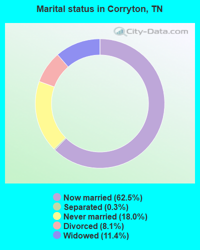
- Never married: 18.0%
- Now married: 62.5%
- Separated: 0.3%
- Widowed: 11.4%
- Divorced: 8.1%
For population 25 years and over in Corryton:
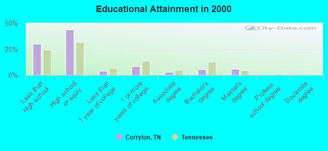
- High school or higher: 70.1%
- Bachelor's degree or higher: 11.3%
- Graduate or professional degree: 6.0%
- Unemployed: 3.4%
- Mean travel time to work (commute): 28.5 minutes
| Here: | 13.1 |
| Tennessee average: | 13.3 |
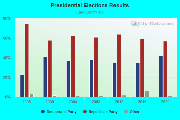
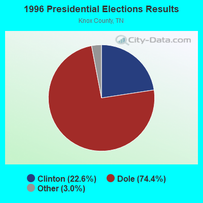
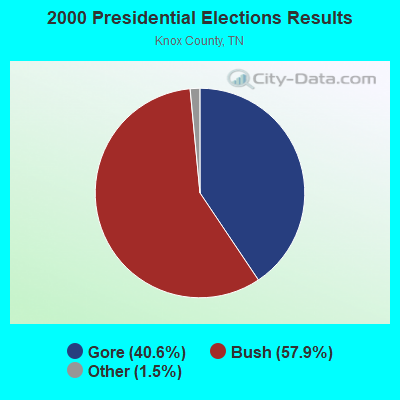
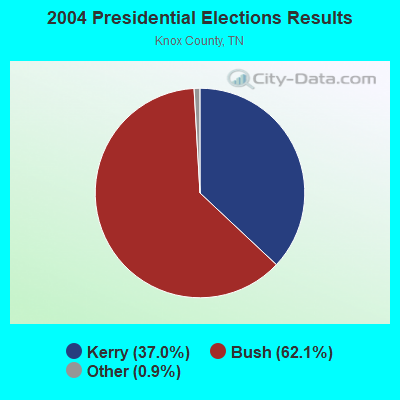
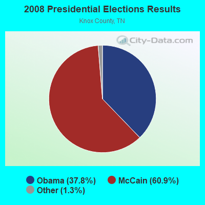
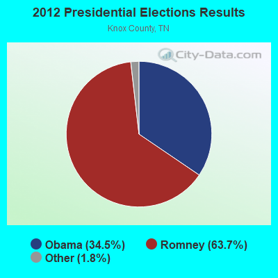
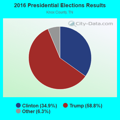
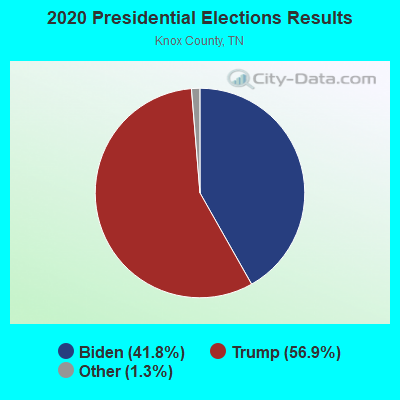
Graphs represent county-level data. Detailed 2008 Election Results
Religion statistics for Corryton, TN (based on Knox County data)
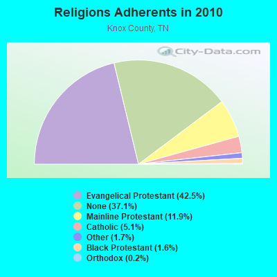
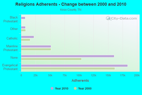
| Religion | Adherents | Congregations |
|---|---|---|
| Evangelical Protestant | 183,754 | 365 |
| Mainline Protestant | 51,345 | 116 |
| Catholic | 21,988 | 7 |
| Other | 7,178 | 34 |
| Black Protestant | 6,897 | 29 |
| Orthodox | 818 | 2 |
| None | 160,246 | - |
Food Environment Statistics:
| Knox County: | 1.75 / 10,000 pop. |
| Tennessee: | 1.99 / 10,000 pop. |
| Knox County: | 0.12 / 10,000 pop. |
| Tennessee: | 0.17 / 10,000 pop. |
| This county: | 1.37 / 10,000 pop. |
| State: | 0.65 / 10,000 pop. |
| Knox County: | 3.82 / 10,000 pop. |
| Tennessee: | 5.16 / 10,000 pop. |
| This county: | 7.39 / 10,000 pop. |
| Tennessee: | 6.56 / 10,000 pop. |
| Here: | 12.0% |
| Tennessee: | 11.4% |
| Knox County: | 27.5% |
| Tennessee: | 30.2% |
| This county: | 13.7% |
| State: | 13.5% |
8.03% of this county's 2021 resident taxpayers lived in other counties in 2020 ($70,106 average adjusted gross income)
| Here: | 8.03% |
| Tennessee average: | 8.49% |
0.02% of residents moved from foreign countries ($141 average AGI)
Knox County: 0.02% Tennessee average: 0.02%
Top counties from which taxpayers relocated into this county between 2020 and 2021:
| from Blount County, TN | |
| from Anderson County, TN | |
| from Sevier County, TN |
| Businesses in Corryton, TN | ||||
| Name | Count | Name | Count | |
|---|---|---|---|---|
| Baskin-Robbins | 1 | Subway | 1 | |
| CVS | 1 | Walgreens | 1 | |
Strongest AM radio stations in Corryton:
- WKVL (850 AM; daytime; 50 kW; KNOXVILLE, TN; Owner: HORNE RADIO, LLC)
- WNOX (990 AM; 10 kW; KNOXVILLE, TN)
- WVLZ (1180 AM; daytime; 10 kW; KNOXVILLE, TN; Owner: KIRKLAND WIRELESS BROADCASTERS, INC.)
- WRJZ (620 AM; 5 kW; KNOXVILLE, TN; Owner: TENNESSEE MEDIA ASSOCIATES, INC)
- WQBB (1040 AM; daytime; 10 kW; POWELL, TN; Owner: JOURNAL BROADCAST CORPORATION)
- WMEN (760 AM; daytime; 2 kW; KNOXVILLE, TN; Owner: THOMAS MOFFIT JR.)
- WSEV (930 AM; 5 kW; SEVIERVILLE, TN; Owner: EAST TENNESSEE RADIO GROUP, L.P.)
- WMTN (1300 AM; 5 kW; MORRISTOWN, TN)
- WCRK (1150 AM; 5 kW; MORRISTOWN, TN; Owner: RADIO ACQUISITION CORP.)
- WFGW (1010 AM; 50 kW; BLACK MOUNTAIN, NC; Owner: BLUE RIDGE BROADCASTING CORP.)
- WATO (1290 AM; 5 kW; OAK RIDGE, TN)
- WLFJ (660 AM; daytime; 50 kW; GREENVILLE, SC; Owner: CLEAR CHANNEL BROADCASTING LICENSES, INC.)
- WKXV (900 AM; 1 kW; KNOXVILLE, TN; Owner: RA-TEL BROADCASTING COMPANY, INC.)
Strongest FM radio stations in Corryton:
- WIMZ-FM (103.5 FM; KNOXVILLE, TN; Owner: SOUTH CENTRAL COMM., CORP.)
- WUOT (91.9 FM; KNOXVILLE, TN; Owner: UNIVERSITY OF TENNESSEE)
- WOKI-FM (100.3 FM; OAK RIDGE, TN; Owner: OAK RIDGE FM, INC.)
- WJXB-FM (97.5 FM; KNOXVILLE, TN; Owner: SOUTH CENTRAL COMMUNICATIONS CORP.)
- WRMX-FM (106.7 FM; NORRIS, TN; Owner: SOUTH CENTRAL COMMUNICATIONS CORPORATION)
- WIVK-FM (107.7 FM; KNOXVILLE, TN; Owner: CITADEL BROADCASTING COMPANY)
- WYLV (89.1 FM; ALCOA, TN; Owner: FOOTHILLS BROADCASTING, INC.)
- WWST (102.1 FM; SEVIERVILLE, TN; Owner: JOURNAL BROADCAST CORPORATION)
- WEZG (99.3 FM; JEFFERSON CITY, TN; Owner: EAST TENNESSEE RADIO GROUP, L.P.)
- WDVX (89.9 FM; CLINTON, TN; Owner: CUMBERLAND COMMUNITIES COMMUNI CORP.)
- WYFC (95.3 FM; CLINTON, TN; Owner: BIBLE BROADCASTING NETWORK, INC.)
- WKHT (104.5 FM; KNOXVILLE, TN; Owner: JOURNAL BROADCAST CORPORATION)
- WCTU (105.9 FM; TAZEWELL, TN; Owner: STAIR COMPANY, INC)
- WMIK-FM (92.7 FM; MIDDLESBORO, KY; Owner: GATEWAY BROADCASTING, INC.)
- WJBZ-FM (96.3 FM; SEYMOUR, TN; Owner: SEYMOUR COMMUNICATIONS)
- WYIL-FM (98.7 FM; OLIVER SPRINGS, TN; Owner: CITADEL BROADCASTING COMPANY)
- WMXK (94.1 FM; MORRISTOWN, TN; Owner: HORNE RADIO, LLC)
- WBGQ (100.7 FM; BULLS GAP, TN; Owner: CHEROKEE BROADCASTING)
- WSEV-FM (105.5 FM; GATLINBURG, TN; Owner: EAST TENNESSEE RADIO GROUP, L.P.)
- W237AR (95.3 FM; HAZELWOOD, ETC., NC; Owner: WESTERN NORTH CAROLINA PUBLIC RADIO)
TV broadcast stations around Corryton:
- WKOP-TV (Channel 15; KNOXVILLE, TN; Owner: EAST TENNESSEE PUBLIC COMMUNICATIONS CORP.)
- WBIR-TV (Channel 10; KNOXVILLE, TN; Owner: GANNETT PACIFIC CORPORATION)
- WATE-TV (Channel 6; KNOXVILLE, TN; Owner: WATE, G.P.)
- WVLT-TV (Channel 8; KNOXVILLE, TN; Owner: WVLT LICENSEE CORP.)
- WTNZ (Channel 43; KNOXVILLE, TN; Owner: RAYCOM AMERICA, INC.)
- WEZK-LP (Channel 28; KNOXVILLE, TN; Owner: SOUTH CENTRAL COMMUNICATIONS CORP.)
- WEEE-LP (Channel 32; KNOXVILLE, TN; Owner: TIGER EYE BROADCASTING CORPORATION)
- W50CG (Channel 50; KNOXVILLE, TN; Owner: THREE ANGELS BROADCASTING NETWORK, INC.)
- WDTT-LP (Channel 38; LENOIR CITY, TN; Owner: WORD OF GOD FELLOWSHIP, INC.)
- W56CM (Channel 56; KNOXVILLE, TN; Owner: VENTANA TELEVISION, INC.)
- WVLR (Channel 48; TAZEWELL, TN; Owner: VOLUNTEER CHRISTIAN TELEVISION, INC.)
- W46DC (Channel 46; KNOXVILLE, TN; Owner: TRINITY BROADCASTING NETWORK)
- W50AB (Channel 50; HIAWASSEE, GA; Owner: GEORGIA PUBLIC TELECOMMUNICATIONS COMMISSION)
- WFEM-LP (Channel 12; HEISKELL, ETC., TN; Owner: H. EARL MARLAR)
- WJZC-LP (Channel 22; SEVIERVILLE, TN; Owner: SOUTH CENTRAL COMMUNICATIONS CORP.)
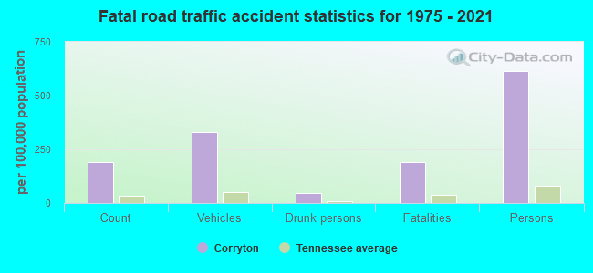
Corryton fatal accident list:
Feb 2, 2013 02:30 AM, Roberts Rd, Lat: 36.122750, Lon: -83.803650, Vehicles: 1, Persons: 1, Fatalities: 1, Drunk persons involved: 1
Jun 15, 2013 06:31 PM, Cr-Boruff Rd, Lat: 36.143386, Lon: -83.827422, Vehicles: 1, Persons: 1, Fatalities: 1
Nov 8, 2006 12:23 AM, Sr-331, Lat: 36.133580, Lon: -83.817310, Vehicles: 2, Persons: 4, Fatalities: 1
FCC Registered Antenna Towers:
74 (See the full list of FCC Registered Antenna Towers in Corryton)FCC Registered Broadcast Land Mobile Towers:
2- Lat: 36.043972 Lon: -83.792694, Call Sign: WQSU589,
Assigned Frequencies: 451.437 MHz, 456.437 MHz, Grant Date: 09/07/2023, Expiration Date: 11/19/2033, Certifier: Greg Morgan, Registrant: Northeast Knox Utility District, 7214 Washington Pike, Corryton, TN 37721, Phone: (865) 687-5345, Email:
- PORTABLES, Lat: 36.119778 Lon: -83.861389, Call Sign: WQZU981,
Assigned Frequencies: 451.262 MHz, 452.162 MHz, 452.437 MHz, 452.112 MHz, 451.987 MHz, 451.512 MHz, 451.412 MHz, 451.312 MHz, 451.762 MHz, 451.662 MHz, Grant Date: 08/10/2017, Expiration Date: 08/10/2027, Certifier: Keith Weaver, Registrant: Metro Communications LLC, 1210 Elm Street, Knoxville, TN 37921, Phone: (865) 546-0311, Fax: (865) 546-8666, Email:
FCC Registered Microwave Towers:
4- GRAVESTON, 270 Hilltop Lane (Lat: 36.169444 Lon: -83.834444), Type: Gtower, Structure height: 91.4 m, Overall height: 94.5 m, Call Sign: WML558,
Assigned Frequencies: 6755.00 MHz, Grant Date: 12/28/2010, Expiration Date: 02/01/2021, Cancellation Date: 04/05/2016, Registrant: Holland & Knight LLP, 800 17th Street, N.W., Suite #1100, Washington, DC 20006-3906, Phone: (202) 955-3000, Fax: (202) 955-5564, Email:
- CORRYTON, 8132 Monday Road (Lat: 36.162750 Lon: -83.784639), Type: Gtower, Structure height: 76.2 m, Overall height: 78.6 m, Call Sign: WQQV706,
Assigned Frequencies: 10795.0 MHz, Grant Date: 03/12/2013, Expiration Date: 03/12/2023, Cancellation Date: 01/04/2016, Certifier: Steven T Campbell, Registrant: Holland & Knight LLP, 800 17th Street, N.W., Suite #1100, Washington, DC 20006-3906, Phone: (202) 955-3000, Fax: (202) 955-5564, Email:
- HOUSE MOUNTAIN, 8764 Bud Hawkins Rd (Lat: 36.112167 Lon: -83.766194), Type: Pole, Structure height: 39.6 m, Call Sign: WQZE928,
Assigned Frequencies: 11305.0 MHz, 11345.0 MHz, 11305.0 MHz, 11345.0 MHz, 11305.0 MHz, 11345.0 MHz, 11305.0 MHz, 11345.0 MHz, 11305.0 MHz, 11345.0 MHz... (+18 more), Grant Date: 04/26/2017, Expiration Date: 04/26/2027, Certifier: Michele Wilson, Registrant: Knoxville Utilities Board, 4505 Middlebrook Pike, Knoxville, TN 37921, Phone: (865) 558-2056, Email:
- Walter Rd AMI Tower, 7727 Walter Rd, Corryton (Lat: 36.161361 Lon: -83.874056), Type: Gtower, Structure height: 36.6 m, Call Sign: WRAR257,
Assigned Frequencies: 11345.0 MHz, 11385.0 MHz, 11345.0 MHz, 11385.0 MHz, 11345.0 MHz, 11385.0 MHz, 11345.0 MHz, 11385.0 MHz, 11345.0 MHz, 11385.0 MHz... (+20 more), Grant Date: 02/05/2018, Expiration Date: 02/05/2028, Certifier: Michele Wilson, Registrant: Micronet Communications, Inc., 812 Lexington Dr, Plano, TX 75075, Phone: (972) 422-7200, Email:
FCC Registered Amateur Radio Licenses:
89 (See the full list of FCC Registered Amateur Radio Licenses in Corryton)FAA Registered Aircraft:
3- Aircraft: CESSNA 150H (Category: Land, Seats: 2, Weight: Up to 12,499 Pounds, Speed: 90 mph), Engine: CONT MOTOR 0-200 SERIES (100 HP) (Reciprocating)
N-Number: 22085, N22085, N-22085, Serial Number: 15068055, Year manufactured: 1967, Airworthiness Date: 12/29/1967, Certificate Issue Date: 12/17/2019
Registrant (Individual): Judd S Chandler, 10310 Rutledge Pike, Corryton, TN 37721 - Aircraft: BEECH V35A (Category: Land, Seats: 6, Weight: Up to 12,499 Pounds, Speed: 150 mph), Engine: CONT MOTOR IO 520 SERIES (285 HP) (Reciprocating)
N-Number: 7879R, N7879R, N-7879R, Serial Number: D-8936, Airworthiness Date: 02/06/1969, Certificate Issue Date: 03/25/2020
Registrant (Co-Owned): Mark T Morgan, Po Box 285, Corryton, TN 37721, Other Owners: Joshua N Twomey - Aircraft: DESTINY AIRCRAFT CORP DESTINY 2000 (Category: Land, Seats: 2, Weight: Up to 12,499 Pounds), Engine: ROTAX 582SER (65 HP) (2 Cycle)
N-Number: 9384S, N9384S, N-9384S, Serial Number: 3G0453, Year manufactured: 2007, Airworthiness Date: 09/30/2007, Certificate Issue Date: 04/17/2018
Registrant (Individual): Greg B Hodges, 5319 Azinger Ln, Corryton, TN 37721
2002 - 2018 National Fire Incident Reporting System (NFIRS) incidents
- Fire incident types reported to NFIRS in Corryton, TN
- 15144.2%Outside Fires
- 13138.3%Structure Fires
- 4914.3%Mobile Property/Vehicle Fires
- 113.2%Other
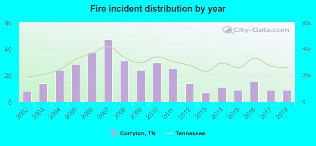 Based on the data from the years 2002 - 2018 the average number of fires per year is 20. The highest number of fires - 47 took place in 2007, and the least - 7 in 2013. The data has an increasing trend.
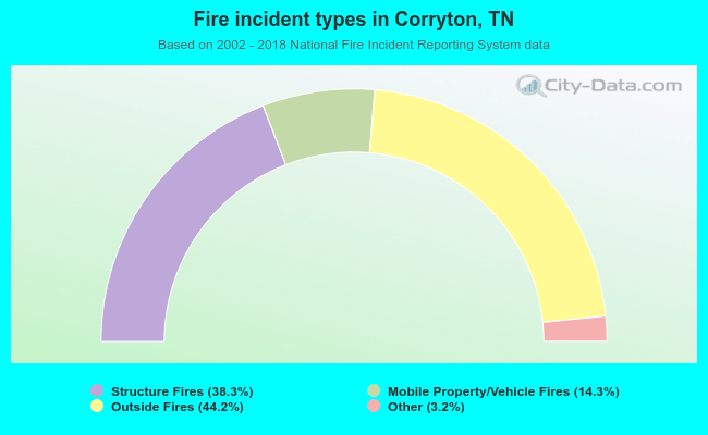 When looking into fire subcategories, the most incidents belonged to: Outside Fires (44.2%), and Structure Fires (38.3%).
| Most common first names in Corryton, TN among deceased individuals | ||
| Name | Count | Lived (average) |
|---|---|---|
| William | 68 | 75.9 years |
| James | 63 | 72.4 years |
| John | 48 | 74.1 years |
| Charles | 42 | 71.4 years |
| Mary | 42 | 75.6 years |
| Robert | 39 | 71.7 years |
| Thomas | 23 | 70.4 years |
| George | 22 | 73.0 years |
| Roy | 18 | 74.6 years |
| Paul | 18 | 68.2 years |
| Most common last names in Corryton, TN among deceased individuals | ||
| Last name | Count | Lived (average) |
|---|---|---|
| Beeler | 33 | 75.6 years |
| Smith | 26 | 74.5 years |
| Clapp | 25 | 76.6 years |
| Walker | 22 | 74.8 years |
| Davis | 21 | 72.0 years |
| Graves | 20 | 73.5 years |
| Parker | 20 | 77.8 years |
| Jones | 18 | 73.6 years |
| Collins | 17 | 72.1 years |
| Sharp | 17 | 78.6 years |
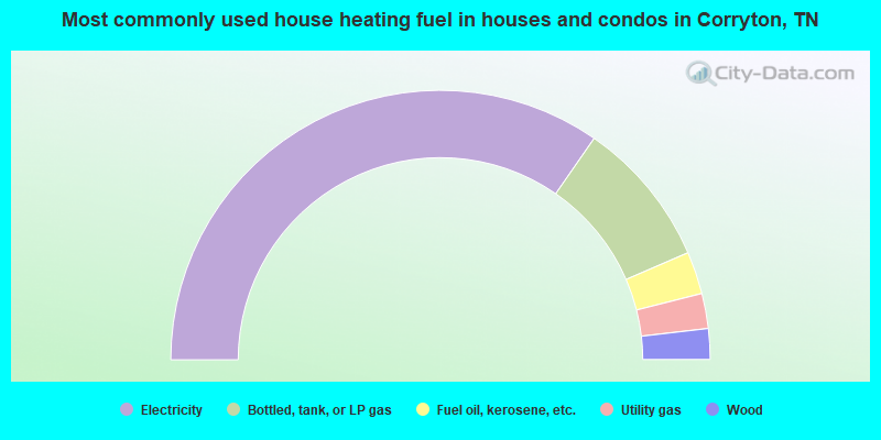
- 69.3%Electricity
- 17.7%Bottled, tank, or LP gas
- 5.1%Fuel oil, kerosene, etc.
- 4.2%Utility gas
- 3.7%Wood
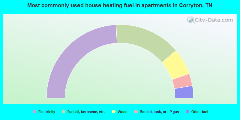
- 48.3%Electricity
- 29.3%Fuel oil, kerosene, etc.
- 11.6%Wood
- 5.4%Bottled, tank, or LP gas
- 5.4%Other fuel
Corryton compared to Tennessee state average:
- Unemployed percentage significantly below state average.
- Black race population percentage significantly below state average.
- Hispanic race population percentage significantly below state average.
- Foreign-born population percentage significantly below state average.
- Renting percentage significantly below state average.
- Length of stay since moving in significantly above state average.
- Number of rooms per house significantly below state average.
- House age significantly below state average.
- Percentage of population with a bachelor's degree or higher below state average.

|
|
Total of 35 patent applications in 2008-2024.