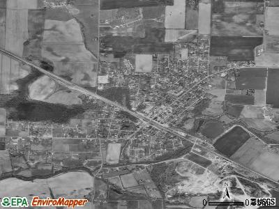
Cowan, Tennessee
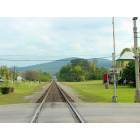
Cowan: Tracks Thur Cowan
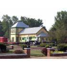
Cowan: Cowan Welcome Center
Cowan: Railroad Museum in Cowan
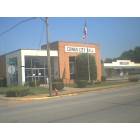
Cowan: the cowan city hall
- add
your


Submit your own pictures of this city and show them to the world
- OSM Map
- General Map
- Google Map
- MSN Map

Population change since 2000: +0.5%
 |
| Males: 874 | |
| Females: 904 |
| Median resident age: | 34.9 years |
| Tennessee median age: | 39.2 years |
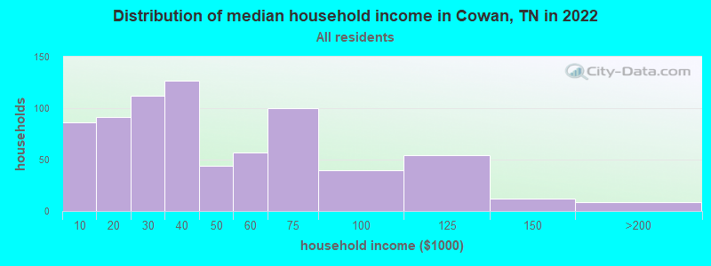
| Cowan: | $34,601 |
| TN: | $65,254 |
Estimated per capita income in 2022: $18,911 (it was $18,352 in 2000)
Cowan city income, earnings, and wages data
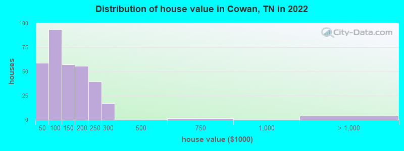
Estimated median house or condo value in 2022: $134,240 (it was $55,100 in 2000)
| Cowan: | $134,240 |
| TN: | $284,800 |
Mean prices in 2022: all housing units: $141,528; detached houses: $146,159; mobile homes: $73,708
Median gross rent in 2022: $732.
(34.6% for White Non-Hispanic residents, 22.9% for Black residents, 20.8% for Hispanic or Latino residents, 26.7% for other race residents, 94.4% for two or more races residents)
Detailed information about poverty and poor residents in Cowan, TN
Compare current foreclosures near Cowan, TN:
| Photo | Address | Area | Beds / Baths | Price | Details |
|---|---|---|---|---|---|

|
#1
Jackson St
Cowan, TN 37318
|
2,224 sq. feet
|
2 baths 3 beds |
show details | |

|
#2
Jackson St
Cowan, TN 37318
|
1,314 sq. feet
|
2 baths 4 beds |
show details | |

|
#3
Garner St
Cowan, TN 37318
|
- sq. feet
|
2 baths 3 beds |
show details | |

|
#4
Church St
Cowan, TN 37318
|
- sq. feet
|
- baths - beds |
show details | |

|
#5
Bjs Lndg
Estill Springs, TN 37330
|
1,326 sq. feet
|
2 baths 3 beds |
show details | |

|
#6
N West St
Decherd, TN 37324
|
1,742 sq. feet
|
2 baths 4 beds |
show details | |

|
#7
Twerp Trl
Estill Springs, TN 37330
|
1,129 sq. feet
|
2 baths 3 beds |
show details | |

|
#8
Bible Crossing Rd
Winchester, TN 37398
|
1,446 sq. feet
|
2 baths - beds |
show details | |

|
#9
S Pittsburg Mountain Rd
Sewanee, TN 37375
|
2,576 sq. feet
|
2 baths - beds |
show details | |

|
#10
Deepwoods Rd
Sewanee, TN 37375
|
2,580 sq. feet
|
4 baths - beds |
show details |
| Photo | Address | Area | Beds / Baths | Price | Details |
|---|---|---|---|---|---|

|
#11
Haddon Ln
Winchester, TN 37398
|
896 sq. feet
|
1 baths - beds |
show details | |

|
#12
Rock Creek Rd
Estill Springs, TN 37330
|
1,500 sq. feet
|
2 baths - beds |
show details | |

|
#13
Mckinney St
Estill Springs, TN 37330
|
1,275 sq. feet
|
2 baths - beds |
show details | |

|
#14
Deer Cir
Estill Springs, TN 37330
|
1,581 sq. feet
|
2 baths - beds |
show details | |

|
#15
Hope Dr
Estill Springs, TN 37330
|
1,305 sq. feet
|
2 baths - beds |
show details | |

|
#16
Red Hawk Ln
Winchester, TN 37398
|
1,176 sq. feet
|
1 baths - beds |
show details | |

|
#17
Goodman Rd
Pelham, TN 37366
|
960 sq. feet
|
1 baths - beds |
show details | |

|
#18
Sweetens Cove Rd
South Pittsburg, TN 37380
|
1,960 sq. feet
|
1 baths - beds |
show details | |

|
#19
Pleasant Grove Rd
Estill Springs, TN 37330
|
1,120 sq. feet
|
1 baths - beds |
show details | |

|
#20
Gudger Rd
Sewanee, TN 37375
|
1,440 sq. feet
|
1 baths - beds |
show details |
| Photo | Address | Area | Beds / Baths | Price | Details |
|---|---|---|---|---|---|

|
#21
Jean Dr
Tullahoma, TN 37388
|
1,268 sq. feet
|
2 baths - beds |
show details | |

|
#22
Oakwood Ln
Tullahoma, TN 37388
|
1,526 sq. feet
|
1 baths - beds |
show details | |

|
#23
Swift Ln
Tullahoma, TN 37388
|
1,196 sq. feet
|
2 baths - beds |
show details | |

|
#24
Oakley St
Hillsboro, TN 37342
|
1,200 sq. feet
|
1 baths - beds |
show details | |

|
#25
Limbo Dr
Hillsboro, TN 37342
|
1,728 sq. feet
|
2 baths - beds |
show details | |

|
#26
Turkey Creek Boat Dock Rd
Tullahoma, TN 37388
|
1,242 sq. feet
|
2 baths - beds |
show details | |

|
#27
Alabama St
Huntland, TN 37345
|
780 sq. feet
|
2 baths - beds |
show details | |

|
#28
Old Estill Springs Rd
Tullahoma, TN 37388
|
1,300 sq. feet
|
1 baths - beds |
show details | |

|
#29
Westside Dr
Tullahoma, TN 37388
|
1,248 sq. feet
|
1 baths - beds |
show details | |

|
#30
Lucas St
Huntland, TN 37345
|
2,117 sq. feet
|
1 baths - beds |
show details |
| Photo | Address | Area | Beds / Baths | Price | Details |
|---|---|---|---|---|---|

|
#31
S Pittsburg Mountain Rd
South Pittsburg, TN 37380
|
1,008 sq. feet
|
1 baths - beds |
show details | |

|
#32
Woods Edge Rd
Winchester, TN 37398
|
1,511 sq. feet
|
2 baths - beds |
show details | |

|
#33
Shasteen St
Estill Springs, TN 37330
|
1,200 sq. feet
|
1 baths - beds |
show details | |

|
#34
Brandi Way
Winchester, TN 37398
|
3,802 sq. feet
|
3 baths - beds |
show details | |

|
#35
S Shephard St
Winchester, TN 37398
|
1,566 sq. feet
|
1 baths - beds |
show details | |

|
#36
Mary Sharp Dr
Decherd, TN 37324
|
1,325 sq. feet
|
2 baths - beds |
show details | |

|
#37
Woodland Dr
Decherd, TN 37324
|
1,596 sq. feet
|
2 baths - beds |
show details | |

|
#38
Rotary Dr
Winchester, TN 37398
|
1,120 sq. feet
|
2 baths - beds |
show details | |

|
#39
Powell St
Decherd, TN 37324
|
1,064 sq. feet
|
2 baths - beds |
show details | |

|
#40
Spring St
Decherd, TN 37324
|
1,480 sq. feet
|
1 baths - beds |
show details |
| Photo | Address | Area | Beds / Baths | Price | Details |
|---|---|---|---|---|---|

|
#41
Old Alto Hwy
Decherd, TN 37324
|
960 sq. feet
|
1 baths - beds |
show details | |

|
#42
Bel Aire Dr
Winchester, TN 37398
|
1,273 sq. feet
|
1 baths - beds |
show details | |

|
#43
W Broad St
Decherd, TN 37324
|
1,568 sq. feet
|
1 baths - beds |
show details | |

|
#44
N 2nd St
Decherd, TN 37324
|
1,340 sq. feet
|
1 baths - beds |
show details | |

|
#45
Roys Ln
Winchester, TN 37398
|
1,300 sq. feet
|
2 baths - beds |
show details | |

|
#46
13th Ave NW
Winchester, TN 37398
|
2,047 sq. feet
|
3 baths - beds |
show details | |

|
#47
Swann Ln
Decherd, TN 37324
|
1,300 sq. feet
|
1 baths - beds |
show details | |

|
#48
S C St
Hillsboro, TN 37342
|
1,152 sq. feet
|
- baths - beds |
show details | |

|
#49
Kings Rd
Sewanee, TN 37375
|
- sq. feet
|
- baths - beds |
show details | |

|
Check over 1 million property listings on Foreclosure.com!
|
browse all offers | |||


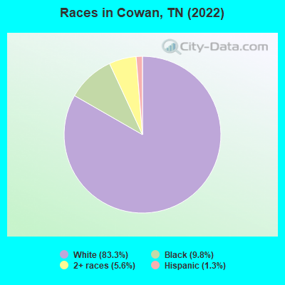
- 1,54983.3%White alone
- 1839.8%Black alone
- 1055.6%Two or more races
- 251.3%Hispanic
- 10.05%Asian alone
Races in Cowan detailed stats: ancestries, foreign born residents, place of birth
According to our research of Tennessee and other state lists, there were 9 registered sex offenders living in Cowan, Tennessee as of April 25, 2024.
The ratio of all residents to sex offenders in Cowan is 169 to 1.
Type |
2009 |
2010 |
2011 |
2012 |
2013 |
2014 |
2015 |
2016 |
2017 |
2018 |
2019 |
2020 |
2021 |
2022 |
|---|---|---|---|---|---|---|---|---|---|---|---|---|---|---|
| Murders (per 100,000) | 0 (0.0) | 0 (0.0) | 0 (0.0) | 0 (0.0) | 0 (0.0) | 0 (0.0) | 0 (0.0) | 0 (0.0) | 0 (0.0) | 0 (0.0) | 0 (0.0) | 0 (0.0) | 0 (0.0) | 0 (0.0) |
| Rapes (per 100,000) | 0 (0.0) | 0 (0.0) | 0 (0.0) | 0 (0.0) | 0 (0.0) | 0 (0.0) | 0 (0.0) | 1 (58.9) | 0 (0.0) | 0 (0.0) | 0 (0.0) | 0 (0.0) | 0 (0.0) | 1 (56.2) |
| Robberies (per 100,000) | 0 (0.0) | 0 (0.0) | 0 (0.0) | 0 (0.0) | 0 (0.0) | 0 (0.0) | 1 (58.4) | 0 (0.0) | 0 (0.0) | 0 (0.0) | 0 (0.0) | 0 (0.0) | 0 (0.0) | 0 (0.0) |
| Assaults (per 100,000) | 6 (350.9) | 0 (0.0) | 3 (171.1) | 4 (229.4) | 5 (293.3) | 7 (408.9) | 3 (175.1) | 4 (235.6) | 6 (357.6) | 4 (242.4) | 1 (60.4) | 6 (363.6) | 3 (180.5) | 9 (505.9) |
| Burglaries (per 100,000) | 7 (409.4) | 4 (230.3) | 1 (57.0) | 5 (286.7) | 7 (410.6) | 1 (58.4) | 13 (758.9) | 7 (412.2) | 7 (417.2) | 5 (303.0) | 3 (181.1) | 6 (363.6) | 0 (0.0) | 1 (56.2) |
| Thefts (per 100,000) | 33 (1,930) | 40 (2,303) | 23 (1,312) | 16 (917.4) | 19 (1,114) | 10 (584.1) | 13 (758.9) | 17 (1,001) | 15 (893.9) | 11 (666.7) | 13 (784.6) | 17 (1,030) | 14 (842.4) | 19 (1,068) |
| Auto thefts (per 100,000) | 1 (58.5) | 0 (0.0) | 1 (57.0) | 1 (57.3) | 0 (0.0) | 2 (116.8) | 1 (58.4) | 2 (117.8) | 1 (59.6) | 2 (121.2) | 0 (0.0) | 4 (242.4) | 3 (180.5) | 2 (112.4) |
| Arson (per 100,000) | 0 (0.0) | 2 (115.1) | 0 (0.0) | 0 (0.0) | 1 (58.7) | 0 (0.0) | 0 (0.0) | 0 (0.0) | 0 (0.0) | 0 (0.0) | 0 (0.0) | 0 (0.0) | 0 (0.0) | 0 (0.0) |
| City-Data.com crime index | 180.7 | 108.2 | 95.3 | 107.2 | 132.0 | 118.6 | 140.7 | 172.6 | 141.2 | 106.1 | 56.1 | 158.8 | 84.2 | 201.8 |
The City-Data.com crime index weighs serious crimes and violent crimes more heavily. Higher means more crime, U.S. average is 246.1. It adjusts for the number of visitors and daily workers commuting into cities.

Crime rate in Cowan detailed stats: murders, rapes, robberies, assaults, burglaries, thefts, arson
Full-time law enforcement employees in 2021, including police officers: 3 (3 officers - 3 male; 0 female).
| Officers per 1,000 residents here: | 1.81 |
| Tennessee average: | 2.57 |
 Recent articles from our blog. Our writers, many of them Ph.D. graduates or candidates, create easy-to-read articles on a wide variety of topics.


 | Nashville Development Thread (1192 replies) |
| What do you LIKE and DISLIKE about living in Knoxville? (191 replies) |
| How would you feel about a third east-west state highway crossing Putnam County end to end? (13 replies) |
| Why are the county roads so poor in western Putnam County? (7 replies) |
| Planned West Cookeville Bypass (4 replies) |
| Knoxville without a car (6 replies) |
Latest news from Cowan, TN collected exclusively by city-data.com from local newspapers, TV, and radio stations
Ancestries: American (25.8%), Irish (15.3%), English (7.9%), German (6.3%), Scotch-Irish (4.3%), Scottish (2.8%).
Current Local Time: CST time zone
Incorporated in 1921
Elevation: 960 feet
Land area: 1.98 square miles.
Population density: 900 people per square mile (low).
17 residents are foreign born
| This city: | 0.9% |
| Tennessee: | 5.4% |
Median real estate property taxes paid for housing units with mortgages in 2022: $940 (0.5%)
Median real estate property taxes paid for housing units with no mortgage in 2022: $774 (0.7%)
Nearest city with pop. 50,000+: Chattanooga, TN  (43.0 miles , pop. 155,554).
Nearest city with pop. 200,000+: Nashville-Davidson, TN (80.3 miles , pop. 545,524).
Nearest city with pop. 1,000,000+: Chicago, IL (470.3 miles , pop. 2,896,016).
Nearest cities:
), ), ), )Latitude: 35.17 N, Longitude: 86.01 W
Area code commonly used in this area: 931
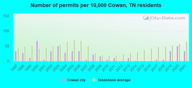
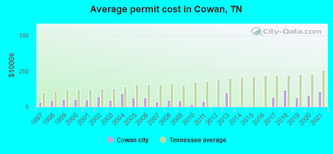
Single-family new house construction building permits:
- 2021: 6 buildings, average cost: $108,800
- 2020: 9 buildings, average cost: $83,300
- 2019: 6 buildings, average cost: $62,800
- 2018: 1 building, cost: $120,000
- 2017: 1 building, cost: $70,000
- 2013: 2 buildings, average cost: $100,000
- 2011: 2 buildings, average cost: $37,500
- 2010: 1 building, cost: $19,000
- 2009: 3 buildings, average cost: $43,000
- 2008: 4 buildings, average cost: $45,500
- 2007: 1 building, cost: $35,000
- 2006: 6 buildings, average cost: $64,200
- 2005: 6 buildings, average cost: $63,000
- 2004: 5 buildings, average cost: $92,500
- 2003: 9 buildings, average cost: $46,400
- 2002: 6 buildings, average cost: $70,800
- 2001: 1 building, cost: $50,000
- 2000: 12 buildings, average cost: $54,300
- 1999: 2 buildings, average cost: $55,000
- 1998: 5 buildings, average cost: $47,000
- 1997: 6 buildings, average cost: $34,200
| Here: | 3.3% |
| Tennessee: | 3.0% |
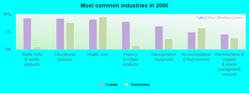
- Textile mills & textile products (9.0%)
- Educational services (8.8%)
- Health care (8.6%)
- Plastics & rubber products (8.0%)
- Transportation equipment (6.6%)
- Accommodation & food services (5.0%)
- Administrative & support & waste management services (4.4%)
- Transportation equipment (9.8%)
- Textile mills & textile products (9.6%)
- Construction (6.8%)
- Administrative & support & waste management services (6.8%)
- Plastics & rubber products (6.8%)
- Educational services (6.3%)
- Utilities (5.1%)
- Health care (16.2%)
- Educational services (11.3%)
- Plastics & rubber products (9.1%)
- Textile mills & textile products (8.4%)
- Finance & insurance (5.9%)
- Accommodation & food services (5.9%)
- Department & other general merchandise stores (4.7%)
- Other production occupations, including supervisors (11.6%)
- Metal workers and plastic workers (8.2%)
- Textile, apparel, and furnishings workers (6.4%)
- Building and grounds cleaning and maintenance occupations (6.0%)
- Other management occupations, except farmers and farm managers (4.9%)
- Other office and administrative support workers, including supervisors (3.9%)
- Assemblers and fabricators (3.5%)
- Other production occupations, including supervisors (16.2%)
- Metal workers and plastic workers (10.4%)
- Building and grounds cleaning and maintenance occupations (7.1%)
- Other management occupations, except farmers and farm managers (6.1%)
- Textile, apparel, and furnishings workers (5.3%)
- Driver/sales workers and truck drivers (4.8%)
- Assemblers and fabricators (3.5%)
- Textile, apparel, and furnishings workers (7.4%)
- Other production occupations, including supervisors (7.1%)
- Metal workers and plastic workers (6.1%)
- Nursing, psychiatric, and home health aides (5.4%)
- Other office and administrative support workers, including supervisors (5.2%)
- Building and grounds cleaning and maintenance occupations (4.9%)
- Cashiers (4.7%)
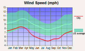
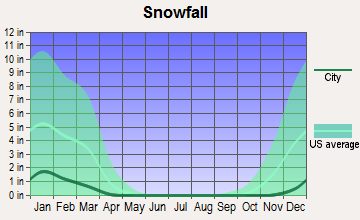
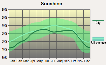
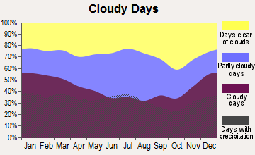
Average climate in Cowan, Tennessee
Based on data reported by over 4,000 weather stations
|
|

Tornado activity:
Cowan-area historical tornado activity is slightly above Tennessee state average. It is 92% greater than the overall U.S. average.
On 4/3/1974, a category F5 (max. wind speeds 261-318 mph) tornado 23.1 miles away from the Cowan city center killed 16 people and injured 190 people.
On 2/13/1952, a category F4 (max. wind speeds 207-260 mph) tornado 5.3 miles away from the city center killed 3 people and injured 44 people and caused between $50,000 and $500,000 in damages.
Earthquake activity:
Cowan-area historical earthquake activity is significantly above Tennessee state average. It is 146% greater than the overall U.S. average.On 4/29/2003 at 08:59:39, a magnitude 4.9 (4.4 MB, 4.6 MW, 4.9 LG, Class: Light, Intensity: IV - V) earthquake occurred 51.4 miles away from the city center
On 4/29/2003 at 08:59:39, a magnitude 4.6 (4.6 MW, Depth: 12.3 mi) earthquake occurred 51.3 miles away from Cowan center
On 4/18/2008 at 09:36:59, a magnitude 5.4 (5.1 MB, 4.8 MS, 5.4 MW, 5.2 MW, Class: Moderate, Intensity: VI - VII) earthquake occurred 249.8 miles away from the city center
On 1/18/1999 at 07:00:53, a magnitude 4.8 (4.8 MB, 4.0 LG, Depth: 0.6 mi) earthquake occurred 141.0 miles away from Cowan center
On 11/30/1973 at 07:48:41, a magnitude 4.7 (4.7 MB, 4.6 ML) earthquake occurred 123.5 miles away from the city center
On 12/12/2018 at 09:14:43, a magnitude 4.4 (4.4 MW, Depth: 4.9 mi) earthquake occurred 78.5 miles away from Cowan center
Magnitude types: regional Lg-wave magnitude (LG), body-wave magnitude (MB), local magnitude (ML), surface-wave magnitude (MS), moment magnitude (MW)
Natural disasters:
The number of natural disasters in Franklin County (11) is smaller than the US average (15).Major Disasters (Presidential) Declared: 8
Emergencies Declared: 2
Causes of natural disasters: Floods: 4, Storms: 4, Tornadoes: 4, Winter Storms: 3, Winds: 2, Flash Flood: 1, Heavy Rain: 1, Hurricane: 1, Ice Storm: 1, Snowfall: 1, Other: 1 (Note: some incidents may be assigned to more than one category).

Hospitals and medical centers near Cowan:
- RCG WINCHESTER (Dialysis Facility, about 4 miles away; WINCHESTER, TN)
- CARESOUTH HHA HOLDINGS OF WINCHESTER, LLC (Home Health Center, about 4 miles away; WINCHESTER, TN)
- GOLDEN LIVINGCENTER - MOUNTAIN VIEW (Nursing Home, about 5 miles away; WINCHESTER, TN)
- SOUTHERN TENNESSEE MEDICAL CENTER Acute Care Hospitals (about 5 miles away; WINCHESTER, TN)
- WILLOWS AT WINCHESTER CARE AND REHABILITATION CENTER (Nursing Home, about 5 miles away; WINCHESTER, TN)
- AMEDISYS HOME CARE (Home Health Center, about 6 miles away; WINCHESTER, TN)
- EMERALD-HODGSON HEALTH CARE CENTER (Nursing Home, about 7 miles away; SEWANEE, TN)
Colleges/universities with over 2000 students nearest to Cowan:
- Motlow State Community College (about 22 miles; Tullahoma, TN; Full-time enrollment: 2,915)
- The University of Tennessee-Chattanooga (about 42 miles; Chattanooga, TN; FT enrollment: 10,158)
- Alabama A & M University (about 42 miles; Normal, AL; FT enrollment: 4,524)
- Northeast Alabama Community College (about 44 miles; Rainsville, AL; FT enrollment: 2,409)
- Chattanooga State Community College (about 45 miles; Chattanooga, TN; FT enrollment: 6,827)
- University of Alabama in Huntsville (about 47 miles; Huntsville, AL; FT enrollment: 6,006)
- Middle Tennessee State University (about 52 miles; Murfreesboro, TN; FT enrollment: 21,628)
Public elementary/middle schools in Cowan:
- COWAN ELEMENTARY (Students: 333, Location: 501 EAST CUMBERLAND ST, Grades: PK-5)
- SOUTH MIDDLE SCHOOL (Students: 317, Location: 601 WEST CUMBERLAND ST, Grades: 6-8)
Points of interest:
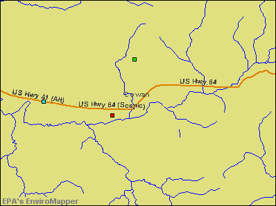
Notable locations in Cowan: Cowan Fire Department Station 2 (A), Cowan Fire Department Station 1 (B), Cowan City Hall (C), Cowan Railroad Museum (D). Display/hide their locations on the map
Churches in Cowan include: Cowan Church of Christ (A), First Baptist Church (B), Cowan Cumberland Presbyterian Church (C), First Church of the Nazarene (D). Display/hide their locations on the map
Cemeteries: Montgomery Cemetery (1), Mullikin Cemetery (2). Display/hide their locations on the map
Swamps: Stewart Swamp (A). Display/hide its location on the map
Drinking water stations with addresses in Cowan and their reported violations in the past:
COWAN BOARD OF PUBLIC UTILITIE (Population served: 2,463, Groundwater under infl of surface water):Past health violations:Past monitoring violations:
- MCL, Monthly (TCR) - In AUG-2009, Contaminant: Coliform. Follow-up actions: St Compliance achieved (SEP-30-2009), St Public Notif requested (OCT-09-2009), St Violation/Reminder Notice (OCT-09-2009)
- Monitoring and Reporting (DBP) - Between JUL-2013 and SEP-2013, Contaminant: TTHM. Follow-up actions: St Public Notif requested (OCT-28-2013), St Violation/Reminder Notice (OCT-28-2013), St Public Notif received (JUN-20-2014)
- Monitoring and Reporting (DBP) - Between JUL-2013 and SEP-2013, Contaminant: Total Haloacetic Acids (HAA5). Follow-up actions: St Public Notif received (JUN-20-2014)
| This city: | 2.3 people |
| Tennessee: | 2.5 people |
| This city: | 63.6% |
| Whole state: | 67.3% |
| This city: | 5.2% |
| Whole state: | 5.8% |
Likely homosexual households (counted as self-reported same-sex unmarried-partner households)
- Lesbian couples: 0.0% of all households
- Gay men: 0.4% of all households
7 people in homes or halfway houses for drug/alcohol abuse in 2000
Banks with branches in Cowan (2011 data):
- Franklin County United Bank: Cowan Branch at 105 Front Street South, branch established on 2007/05/01. Info updated 2006/11/03: Bank assets: $93.9 mil, Deposits: $82.3 mil, headquarters in Decherd, TN, positive income, Commercial Lending Specialization, 2 total offices
For population 15 years and over in Cowan:
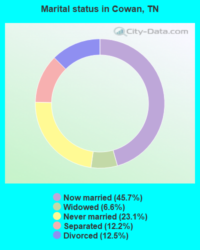
- Never married: 23.1%
- Now married: 45.7%
- Separated: 12.2%
- Widowed: 6.6%
- Divorced: 12.5%
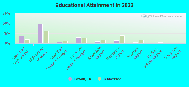
For population 25 years and over in Cowan:
- High school or higher: 78.5%
- Bachelor's degree or higher: 10.4%
- Graduate or professional degree: 3.9%
- Unemployed: 3.7%
- Mean travel time to work (commute): 24.1 minutes

| Here: | 11.7 |
| Tennessee average: | 11.4 |
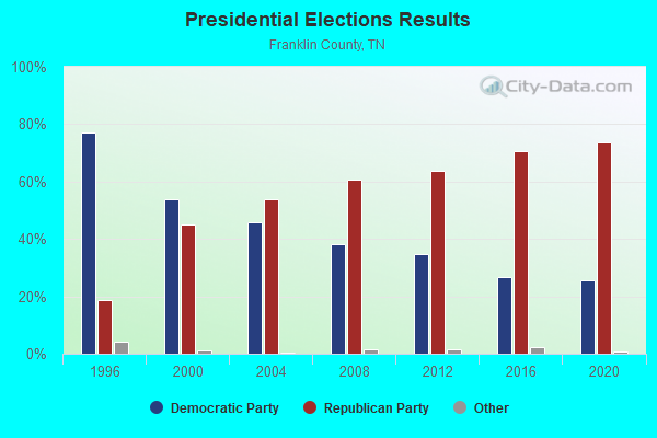
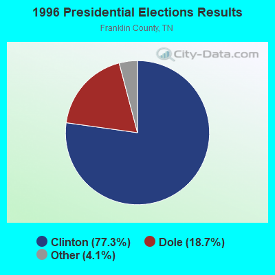

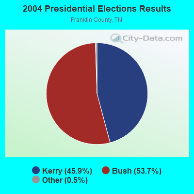
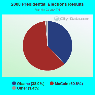

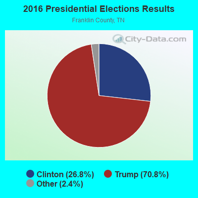

Graphs represent county-level data. Detailed 2008 Election Results
Religion statistics for Cowan, TN (based on Franklin County data)
| Religion | Adherents | Congregations |
|---|---|---|
| Evangelical Protestant | 15,502 | 80 |
| Mainline Protestant | 3,525 | 20 |
| Catholic | 800 | 1 |
| Black Protestant | 480 | 4 |
| Other | 4 | 2 |
| None | 20,741 | - |
Food Environment Statistics:
| This county: | 2.68 / 10,000 pop. |
| Tennessee: | 1.99 / 10,000 pop. |
| Franklin County: | 0.24 / 10,000 pop. |
| Tennessee: | 0.17 / 10,000 pop. |
| Franklin County: | 0.73 / 10,000 pop. |
| Tennessee: | 0.65 / 10,000 pop. |
| This county: | 6.57 / 10,000 pop. |
| State: | 5.16 / 10,000 pop. |
| Franklin County: | 5.11 / 10,000 pop. |
| State: | 6.56 / 10,000 pop. |
| Franklin County: | 10.6% |
| Tennessee: | 11.4% |
| Here: | 30.1% |
| State: | 30.2% |
| Here: | 14.9% |
| State: | 13.5% |
Health and Nutrition:
| Cowan: | 49.8% |
| Tennessee: | 49.3% |
| This city: | 46.1% |
| Tennessee: | 46.1% |
| Cowan: | 28.9 |
| Tennessee: | 28.8 |
| Cowan: | 19.3% |
| State: | 21.0% |
| Cowan: | 10.2% |
| Tennessee: | 10.5% |
| Cowan: | 6.8 |
| Tennessee: | 6.8 |
| Cowan: | 35.9% |
| Tennessee: | 33.9% |
| This city: | 55.7% |
| Tennessee: | 55.9% |
| Cowan: | 77.5% |
| Tennessee: | 79.1% |
More about Health and Nutrition of Cowan, TN Residents
| Local government employment and payroll (March 2022) | |||||
| Function | Full-time employees | Monthly full-time payroll | Average yearly full-time wage | Part-time employees | Monthly part-time payroll |
|---|---|---|---|---|---|
| Solid Waste Management | 4 | $11,702 | $35,106 | 0 | $0 |
| Police Protection - Officers | 3 | $10,450 | $41,800 | 2 | $2,533 |
| Financial Administration | 1 | $3,328 | $39,936 | 0 | $0 |
| Fire - Other | 0 | $0 | 1 | $100 | |
| Other Government Administration | 0 | $0 | 6 | $1,050 | |
| Totals for Government | 8 | $25,480 | $38,220 | 9 | $3,683 |
Cowan government finances - Expenditure in 2017 (per resident):
- Current Operations - Libraries: $4,000 ($2.25)
- General - Interest on Debt: $21,000 ($11.81)
- Total Salaries and Wages: $289,000 ($162.54)
Cowan government finances - Revenue in 2017 (per resident):
- Charges - Solid Waste Management: $103,000 ($57.93)
- Revenue - Water Utilities: $1,758,000 ($988.75)
- State Intergovernmental - Water Utilities: $334,000 ($187.85)
Highways: $114,000 ($64.12)
- Tax - Property: $487,000 ($273.90)
General Sales and Gross Receipts: $141,000 ($79.30)
Public Utilities Sales: $22,000 ($12.37)
Alcoholic Beverage Sales: $3,000 ($1.69)
Cowan government finances - Debt in 2017 (per resident):
- Long Term Debt - Beginning Outstanding - Unspecified Public Purpose: $526,000 ($295.84)
Outstanding Unspecified Public Purpose: $369,000 ($207.54)
Retired Unspecified Public Purpose: $157,000 ($88.30)
Strongest AM radio stations in Cowan:
- WZYX (1440 AM; 5 kW; COWAN, TN; Owner: TIMS FORD BROADCASTING COMPANY, INC.)
- WWAM (820 AM; daytime; 50 kW; JASPER, TN; Owner: SHELTON BROADCASTING SYSTEM)
- WCDT (1340 AM; 1 kW; WINCHESTER, TN; Owner: FRANKLIN COUNTY RADIO & B/CTING, INC)
- WFLI (1070 AM; 50 kW; LOOKOUT MOUNTAIN, TN; Owner: WFLI, INC.)
- WLOR (1550 AM; 50 kW; HUNTSVILLE, AL; Owner: BCA RADIO, LLC)
- WSM (650 AM; 50 kW; NASHVILLE, TN; Owner: GAYLORD ENTERTAINMENT COMPANY)
- WEPG (910 AM; 5 kW; SOUTH PITTSBURG, TN; Owner: STONE/COLLINS COMMUNICATIONS, INC.)
- WBXR (1140 AM; daytime; 15 kW; HAZEL GREEN, AL; Owner: LOW COUNTRY CORPORATION, INC.)
- WMSR (1320 AM; 5 kW; MANCHESTER, TN; Owner: COFFEE COUNTY BROADCASTING, INC.)
- WNSI (810 AM; 50 kW; JACKSONVILLE, AL; Owner: UNITED BROADCASTING NETWORK, INC.)
- WAMB (1160 AM; 50 kW; DONELSON, TN; Owner: GREAT SOUTHERN BROADCASTING COMPANY, INC.)
- WKDA (1200 AM; 50 kW; NASHVILLE, TN; Owner: RADIO NASHVILLE, INC.)
- WNQM (1300 AM; 50 kW; NASHVILLE, TN; Owner: WNQM. INC.)
Strongest FM radio stations in Cowan:
- WUSX (93.3 FM; TULLAHOMA, TN; Owner: TENNNESSE VALLEY RADIO, INC)
- WMXF-FM (97.3 FM; SOUTH PITTSBURG, TN; Owner: CAPSTAR TX LIMITED PARTNERSHIP)
- WUSY (100.7 FM; CLEVELAND, TN; Owner: CAPSTAR TX LIMITED PARTNERSHIP)
- WMBW (88.9 FM; CHATTANOOGA, TN; Owner: THE MOODY BIBLE INSTITUTE OF CHICAGO)
- WSGM (104.7 FM; COALMONT, TN; Owner: CUMBERLAND COMMUNICATION CORPORATION)
- WAHR (99.1 FM; HUNTSVILLE, AL; Owner: BCA RADIO, LLC)
- WWTN (99.7 FM; MANCHESTER, TN; Owner: CUMULUS LICENSING CORP.)
- WBDX (102.7 FM; TRENTON, GA; Owner: PARTNERS FOR CHRISTIAN RADIO, INC.)
- W289AC (105.7 FM; HUNTSVILLE, AL; Owner: WILLIAM PAXTON ROGERS)
- W257AZ (99.3 FM; LOOKOUT MOUNTAIN, TN; Owner: CAPSTAR TX LIMITED PARTNERSHIP)
- WDEF-FM (92.3 FM; CHATTANOOGA, TN; Owner: JACKSON TELECASTERS, INC.)
- WDOD-FM (96.5 FM; CHATTANOOGA, TN; Owner: WDOD OF CHATTANOOGA, INC.)
- WSKZ (106.5 FM; CHATTANOOGA, TN; Owner: CITADEL BROADCASTING COMPANY)
- WXQW (94.1 FM; MERIDIANVILLE, AL; Owner: CAPSTAR TX LIMITED PARTNERSHIP)
- W293AH (106.5 FM; NORMAL, AL; Owner: CAPSTAR TX LIMITED PARTNERSHIP)
- WMXN-FM (101.7 FM; STEVENSON, AL; Owner: KEA RADIO, INC.)
- WOGT (107.9 FM; EAST RIDGE, TN; Owner: CITADEL BROADCASTING COMPANY)
- WFTZ (101.5 FM; MANCHESTER, TN; Owner: PHASE TWO COMMUNICATIONS, INC.)
- W278AC (103.5 FM; WALDEN, TN; Owner: CAPSTAR TX LIMITED PARTNERSHIP)
- W249BB (97.7 FM; HUNTSVILLE, AL; Owner: WAY-FM MEDIA GROUP, INC.)
TV broadcast stations around Cowan:
- WFLI-TV (Channel 53; CLEVELAND, TN; Owner: CHATTANOOGA MEDIA HOLDINGS, L.L.C.)
- WZDX (Channel 54; HUNTSVILLE, AL; Owner: HUNTSVILLE TELEVISION ACQUISITION CORP.)
- WAAY-TV (Channel 31; HUNTSVILLE, AL; Owner: PIEDMONT TELEVISION OF HUNTSVILLE LICENSE LLC)
- WHNT-TV (Channel 19; HUNTSVILLE, AL; Owner: NEW YORK TIMES MANAGEMENT SERVICES)
- W64BJ (Channel 64; SCOTTSBORO, AL; Owner: TRINITY BROADCASTING NETWORK)
Cowan fatal accident list:
Aug 16, 1990 12:50 AM, Sr15, Vehicles: 2, Persons: 2, Fatalities: 1
Mar 8, 1987 10:21 PM, Vehicles: 2, Persons: 2, Fatalities: 1, Drunk persons involved: 1
Nov 25, 1978 06:49 PM, Vehicles: 1, Persons: 2, Fatalities: 1
- National Bridge Inventory (NBI) Statistics
- 11Number of bridges
- 52ft / 15.7mTotal length
- $754,000Total costs
- 10,746Total average daily traffic
- 967Total average daily truck traffic
- 17,191Total future (year 2039) average daily traffic
- New bridges - historical statistics
- 41930-1939
- 11950-1959
- 11960-1969
- 41980-1989
- 11990-1999
FCC Registered Cell Phone Towers:
1 (See the full list of FCC Registered Cell Phone Towers in Cowan)FCC Registered Antenna Towers:
23 (See the full list of FCC Registered Antenna Towers)FCC Registered Broadcast Land Mobile Towers:
2- L5, Lat: 35.164806 Lon: -86.011333, Call Sign: KYL716,
Assigned Frequencies: 160.785 MHz, Grant Date: 03/19/2024, Expiration Date: 05/25/2034, Certifier: L W Allen, Registrant: Csx Transportation Inc, 6735 Southpoint Dr S, Suite 400, Jacksonville, FL 32216, Phone: (904) 279-6938, Email:
- TANK, Approx. 800 Ft Northwest Of Hwy41a And Henderson Lane (Lat: 35.165556 Lon: -86.035000), Type: Pole, Structure height: 6 m, Call Sign: WQKV514,
Assigned Frequencies: 453.587 MHz, Grant Date: 07/26/2019, Expiration Date: 09/25/2029, Certifier: William A Garner, Registrant: Federal Licensing Inc, 1588 Fairfield Road, Gettysburg, PA 17325, Phone: (717) 334-9262, Fax: (717) 334-6440, Email:
FCC Registered Microwave Towers:
1- NA COWAN, 301 Hodge Street (Lat: 35.166694 Lon: -86.012722), Type: Mast, Structure height: 85.6 m, Overall height: 86.9 m, Call Sign: WQNH684,
Assigned Frequencies: 10795.0 MHz, Grant Date: 02/08/2011, Expiration Date: 02/08/2021, Cancellation Date: 03/12/2018, Certifier: Christopher L Harris, Registrant: Conterra Ultra Broadband, LLC, 2101 Rexford Road Suite 200 E, Charlotte, NC 28211, Phone: (704) 936-1801, Fax: (704) 936-1801, Email:
FCC Registered Amateur Radio Licenses:
1- Call Sign: W7LGD, Previous Call Sign: W8LGD, Licensee ID: L00202241, Grant Date: 11/13/2009, Expiration Date: 02/05/2020, Cancellation Date: 02/08/2022, Certifier: Edwin F Hohenthaner, Registrant: Edwin F Hohenthaner, 717 Mc Kown St, Cowan, TN 37318
FAA Registered Aircraft:
1- Aircraft: MOONEY M20E (Category: Land, Seats: 4, Weight: Up to 12,499 Pounds, Speed: 127 mph), Engine: LYCOMING I0360 SER (180 HP) (Reciprocating)
N-Number: 1260X, N1260X, N-1260X, Serial Number: 133, Year manufactured: 1963, Airworthiness Date: 10/09/1963, Certificate Issue Date: 09/30/2003
Registrant (Individual): Paul D Cross, 700 Cumberland St E, Cowan, TN 37318
2002 - 2018 National Fire Incident Reporting System (NFIRS) incidents
- Fire incident types reported to NFIRS in Cowan, TN
- 9143.1%Structure Fires
- 7736.5%Outside Fires
- 3617.1%Mobile Property/Vehicle Fires
- 73.3%Other
 According to the data from the years 2002 - 2018 the average number of fire incidents per year is 12. The highest number of fires - 19 took place in 2003, and the least - 5 in 2017. The data has a decreasing trend.
 When looking into fire subcategories, the most reports belonged to: Structure Fires (43.1%), and Outside Fires (36.5%).
| Most common first names in Cowan, TN among deceased individuals | ||
| Name | Count | Lived (average) |
|---|---|---|
| James | 39 | 67.7 years |
| John | 30 | 72.0 years |
| Mary | 26 | 79.6 years |
| William | 17 | 75.3 years |
| Thomas | 17 | 67.7 years |
| Robert | 17 | 72.8 years |
| Charles | 17 | 70.1 years |
| George | 9 | 81.1 years |
| Raymond | 8 | 74.6 years |
| Joe | 8 | 75.9 years |
| Most common last names in Cowan, TN among deceased individuals | ||
| Last name | Count | Lived (average) |
|---|---|---|
| Smith | 24 | 75.2 years |
| Garner | 17 | 71.0 years |
| Hill | 14 | 73.0 years |
| Miller | 13 | 69.1 years |
| Gass | 12 | 73.3 years |
| Morris | 12 | 71.7 years |
| Williams | 12 | 73.1 years |
| Davis | 11 | 74.6 years |
| Jackson | 11 | 81.9 years |
| Ray | 10 | 74.3 years |
- 59.3%Electricity
- 34.8%Utility gas
- 3.2%Wood
- 1.6%Bottled, tank, or LP gas
- 1.1%No fuel used
- 85.3%Electricity
- 13.8%Utility gas
- 0.9%No fuel used
Cowan compared to Tennessee state average:
- Median household income below state average.
- Median house value below state average.
- Unemployed percentage significantly below state average.
- Hispanic race population percentage significantly below state average.
- Foreign-born population percentage significantly below state average.
- Length of stay since moving in significantly above state average.
- House age above state average.
- Number of college students below state average.
- Percentage of population with a bachelor's degree or higher below state average.