De Soto, Missouri

Submit your own pictures of this city and show them to the world
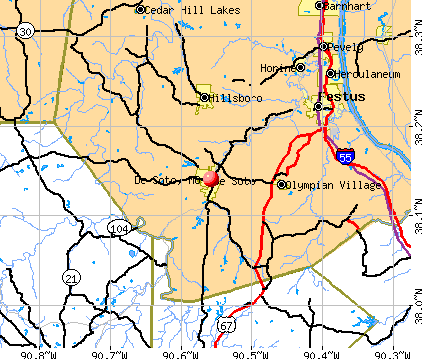
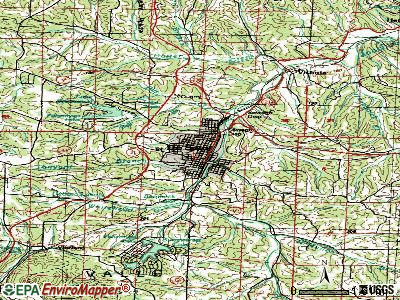
- OSM Map
- General Map
- Google Map
- MSN Map
Population change since 2000: +1.2%
 |
| Males: 2,874 | |
| Females: 3,577 |
| Median resident age: | 34.1 years |
| Missouri median age: | 39.1 years |
Zip codes: 63020.
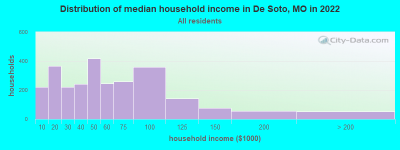
| De Soto: | $45,572 |
| MO: | $64,811 |
Estimated per capita income in 2022: $26,353 (it was $14,971 in 2000)
De Soto city income, earnings, and wages data
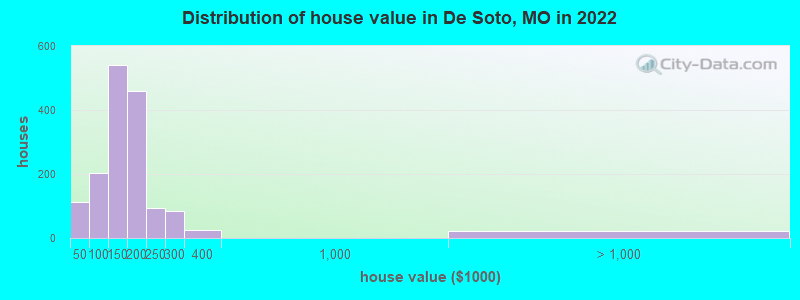
Estimated median house or condo value in 2022: $154,566 (it was $66,900 in 2000)
| De Soto: | $154,566 |
| MO: | $221,200 |
Mean prices in 2022: all housing units: $250,126; detached houses: $266,340; townhouses or other attached units: $218,771; in 2-unit structures: $308,042; in 3-to-4-unit structures: $137,125; in 5-or-more-unit structures: $166,271; mobile homes: $95,722
Median gross rent in 2022: $718.
(11.7% for White Non-Hispanic residents, 100.0% for American Indian residents, 13.1% for two or more races residents)
Detailed information about poverty and poor residents in De Soto, MO


Compare current foreclosures in De Soto, MO:
| Photo | Address | Area | Beds / Baths | Price | Details |
|---|---|---|---|---|---|

|
#1
Williamson Dr
De Soto, MO 63020
|
1,148 sq. feet
|
2 baths 3 beds |
$205,000
|
show details |

|
#2
Rouggly Rd
De Soto, MO 63020
|
1,368 sq. feet
|
1 baths 3 beds |
$99,900
|
show details |

|
#3
W Miller St
De Soto, MO 63020
|
1,910 sq. feet
|
2 baths 3 beds |
show details | |

|
#4
Morse Ave
De Soto, MO 63020
|
392 sq. feet
|
1 baths 3 beds |
show details | |

|
#5
Candy Ln
De Soto, MO 63020
|
1,624 sq. feet
|
3 baths 4 beds |
show details | |

|
#6
Vineland Rd
De Soto, MO 63020
|
951 sq. feet
|
1 baths 2 beds |
show details | |

|
#7
Kronos Dr
De Soto, MO 63020
|
- sq. feet
|
1 baths 2 beds |
show details | |

|
#8
Allen Pl
De Soto, MO 63020
|
- sq. feet
|
1 baths - beds |
show details | |

|
#9
Bogy St
De Soto, MO 63020
|
- sq. feet
|
1 baths 2 beds |
show details | |

|
#10
Morse Ave
De Soto, MO 63020
|
616 sq. feet
|
1 baths - beds |
show details |
| Photo | Address | Area | Beds / Baths | Price | Details |
|---|---|---|---|---|---|

|
#11
Parthenon Dr
De Soto, MO 63020
|
1,056 sq. feet
|
1 baths - beds |
show details | |

|
#12
Parklane Rd
De Soto, MO 63020
|
520 sq. feet
|
1 baths - beds |
show details | |

|
#13
State Road Cc
De Soto, MO 63020
|
784 sq. feet
|
1 baths - beds |
show details | |

|
#14
N 3rd St
De Soto, MO 63020
|
1,256 sq. feet
|
1 baths - beds |
show details | |

|
#15
S 5th St
De Soto, MO 63020
|
864 sq. feet
|
1 baths - beds |
show details | |

|
#16
Kennett St
De Soto, MO 63020
|
930 sq. feet
|
1 baths - beds |
show details | |

|
#17
Flucom Rd
De Soto, MO 63020
|
1,474 sq. feet
|
2 baths - beds |
show details | |

|
#18
Deer Creek Dr
De Soto, MO 63020
|
970 sq. feet
|
1 baths - beds |
show details | |

|
#19
Upper Plattin Rd
De Soto, MO 63020
|
1,344 sq. feet
|
2 baths - beds |
show details | |

|
#20
Mammoth Rd
De Soto, MO 63020
|
2,128 sq. feet
|
3 baths - beds |
show details |
| Photo | Address | Area | Beds / Baths | Price | Details |
|---|---|---|---|---|---|

|
#21
Hill Side Rd
De Soto, MO 63020
|
1,590 sq. feet
|
2 baths - beds |
show details | |

|
#22
Summit Dr
De Soto, MO 63020
|
1,120 sq. feet
|
2 baths - beds |
show details | |

|
#23
Lakewood Dr
De Soto, MO 63020
|
1,440 sq. feet
|
2 baths - beds |
show details | |

|
#24
Kronos Dr
De Soto, MO 63020
|
988 sq. feet
|
1 baths - beds |
show details | |

|
#25
Hencher Rd
De Soto, MO 63020
|
1,800 sq. feet
|
2 baths - beds |
show details | |

|
#26
E Pratt St
De Soto, MO 63020
|
- sq. feet
|
- baths - beds |
show details | |

|
#27
Dewitt St
De Soto, MO 63020
|
- sq. feet
|
- baths - beds |
show details | |

|
#28
Hickory Lndg
De Soto, MO 63020
|
- sq. feet
|
- baths - beds |
show details | |

|
#29
Beatriz Ln
De Soto, MO 63020
|
- sq. feet
|
- baths - beds |
show details | |

|
#30
E Lakeshore Dr
De Soto, MO 63020
|
- sq. feet
|
1 baths - beds |
show details |
| Photo | Address | Area | Beds / Baths | Price | Details |
|---|---|---|---|---|---|

|
#31
N Washington St
De Soto, MO 63020
|
- sq. feet
|
- baths - beds |
show details | |

|
#32
Strawberry Dr
De Soto, MO 63020
|
- sq. feet
|
- baths - beds |
show details | |

|
#33
Victoria Glade Dr
De Soto, MO 63020
|
- sq. feet
|
2 baths - beds |
show details | |

|
#34
Perry St
De Soto, MO 63020
|
- sq. feet
|
- baths - beds |
show details | |

|
#35
Upper Plattin Rd
De Soto, MO 63020
|
- sq. feet
|
1 baths - beds |
show details | |

|
#36
State Rd E
De Soto, MO 63020
|
- sq. feet
|
- baths - beds |
show details | |

|
#37
Eva Dr
De Soto, MO 63020
|
- sq. feet
|
1 baths - beds |
show details | |

|
#38
Quints Rd
De Soto, MO 63020
|
- sq. feet
|
- baths - beds |
show details | |

|
#39
N 2nd St
De Soto, MO 63020
|
- sq. feet
|
- baths - beds |
show details | |

|
#40
Castle Ranch Rd
De Soto, MO 63020
|
- sq. feet
|
- baths - beds |
show details |
| Photo | Address | Area | Beds / Baths | Price | Details |
|---|---|---|---|---|---|

|
#41
Zell Cir
De Soto, MO 63020
|
- sq. feet
|
- baths - beds |
show details | |

|
#42
Rock Rd
De Soto, MO 63020
|
- sq. feet
|
- baths - beds |
show details | |

|
#43
N 10th St
De Soto, MO 63020
|
- sq. feet
|
- baths - beds |
show details | |

|
#44
Fox Farm Rd
De Soto, MO 63020
|
- sq. feet
|
1 baths - beds |
show details | |

|
#45
Clark Subdivision Rd
De Soto, MO 63020
|
- sq. feet
|
- baths - beds |
show details | |

|
#46
N 4th St
De Soto, MO 63020
|
- sq. feet
|
- baths - beds |
show details | |

|
#47
Vineland School Rd
De Soto, MO 63020
|
- sq. feet
|
1 baths - beds |
show details | |

|
#48
Southlake Dr
De Soto, MO 63020
|
- sq. feet
|
2 baths - beds |
show details | |

|
#49
N Washington St
De Soto, MO 63020
|
- sq. feet
|
1 baths - beds |
show details | |

|
Check over 1 million property listings on Foreclosure.com!
|
browse all offers | |||


- 5,62086.5%White alone
- 66510.2%Two or more races
- 560.9%Hispanic
- 270.4%American Indian alone
- 240.4%Asian alone
- 120.2%Other race alone
- 10.02%Black alone
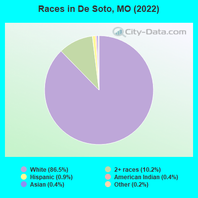
Races in De Soto detailed stats: ancestries, foreign born residents, place of birth
According to our research of Missouri and other state lists, there were 72 registered sex offenders living in De Soto, Missouri as of April 25, 2024.
The ratio of all residents to sex offenders in De Soto is 90 to 1.
Type |
2009 |
2010 |
2011 |
2012 |
2013 |
2014 |
2015 |
2016 |
2017 |
2018 |
2019 |
2020 |
2022 |
|---|---|---|---|---|---|---|---|---|---|---|---|---|---|
| Murders (per 100,000) | 0 (0.0) | 0 (0.0) | 0 (0.0) | 0 (0.0) | 0 (0.0) | 0 (0.0) | 1 (15.4) | 0 (0.0) | 0 (0.0) | 1 (15.7) | 0 (0.0) | 0 (0.0) | 0 (0.0) |
| Rapes (per 100,000) | 1 (15.4) | 0 (0.0) | 2 (31.1) | 0 (0.0) | 1 (15.5) | 2 (30.8) | 2 (30.8) | 2 (30.7) | 1 (15.4) | 2 (31.3) | 2 (31.5) | 0 (0.0) | 1 (15.6) |
| Robberies (per 100,000) | 3 (46.3) | 1 (15.6) | 3 (46.7) | 3 (46.6) | 3 (46.4) | 3 (46.2) | 0 (0.0) | 0 (0.0) | 0 (0.0) | 1 (15.7) | 0 (0.0) | 0 (0.0) | 0 (0.0) |
| Assaults (per 100,000) | 31 (478.5) | 28 (437.5) | 37 (576.1) | 22 (342.0) | 17 (263.2) | 12 (184.9) | 11 (169.6) | 24 (368.6) | 12 (185.0) | 2 (31.3) | 4 (62.9) | 3 (47.3) | 6 (93.5) |
| Burglaries (per 100,000) | 20 (308.7) | 27 (421.9) | 50 (778.5) | 39 (606.2) | 39 (603.7) | 27 (416.0) | 19 (292.9) | 30 (460.7) | 14 (215.8) | 12 (188.1) | 11 (173.1) | 7 (110.4) | 1 (15.6) |
| Thefts (per 100,000) | 199 (3,071) | 160 (2,500) | 242 (3,768) | 253 (3,933) | 266 (4,118) | 220 (3,390) | 185 (2,852) | 159 (2,442) | 123 (1,896) | 75 (1,176) | 106 (1,668) | 85 (1,340) | 11 (171.4) |
| Auto thefts (per 100,000) | 13 (200.6) | 12 (187.5) | 13 (202.4) | 20 (310.9) | 8 (123.8) | 17 (261.9) | 5 (77.1) | 10 (153.6) | 3 (46.2) | 3 (47.0) | 1 (15.7) | 0 (0.0) | 1 (15.6) |
| Arson (per 100,000) | 1 (15.4) | 1 (15.6) | 4 (62.3) | 2 (31.1) | 0 (0.0) | 0 (0.0) | 2 (30.8) | 0 (0.0) | 0 (0.0) | 0 (0.0) | 0 (0.0) | 0 (0.0) | 0 (0.0) |
| City-Data.com crime index | 282.5 | 236.7 | 375.5 | 307.0 | 295.8 | 261.2 | 230.2 | 240.5 | 144.0 | 131.3 | 117.9 | 70.8 | 40.4 |
The City-Data.com crime index weighs serious crimes and violent crimes more heavily. Higher means more crime, U.S. average is 246.1. It adjusts for the number of visitors and daily workers commuting into cities.
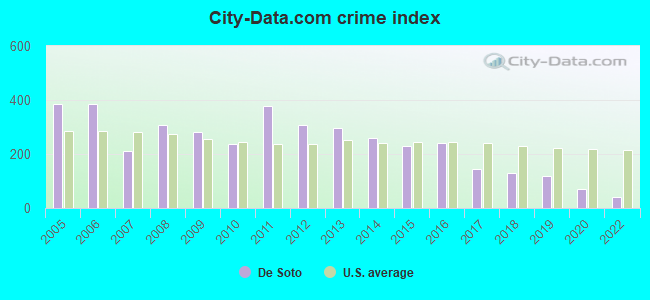
Crime rate in De Soto detailed stats: murders, rapes, robberies, assaults, burglaries, thefts, arson
Full-time law enforcement employees in 2020, including police officers: 28 (19 officers - 15 male; 4 female).
| Officers per 1,000 residents here: | 3.00 |
| Missouri average: | 2.53 |
 Recent articles from our blog. Our writers, many of them Ph.D. graduates or candidates, create easy-to-read articles on a wide variety of topics.


Latest news from De Soto, MO collected exclusively by city-data.com from local newspapers, TV, and radio stations
Ancestries: American (22.7%), German (20.4%), English (14.1%), French (7.4%), Irish (6.4%), Italian (5.1%).
Current Local Time: CST time zone
Incorporated in 1869
Elevation: 503 feet
Land area: 3.81 square miles.
Population density: 1,694 people per square mile (low).
73 residents are foreign born
| This city: | 1.1% |
| Missouri: | 4.2% |
Median real estate property taxes paid for housing units with mortgages in 2022: $1,312 (0.9%)
Median real estate property taxes paid for housing units with no mortgage in 2022: $1,141 (0.7%)
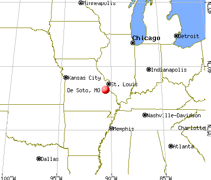
Nearest city with pop. 50,000+: St. Louis, MO  (37.8 miles , pop. 348,189).
Nearest city with pop. 1,000,000+: Chicago, IL (297.9 miles , pop. 2,896,016).
Nearest cities:
), ), ), )Latitude: 38.14 N, Longitude: 90.56 W
Daytime population change due to commuting: +155 (+2.4%)
Workers who live and work in this city: 1,009 (32.5%)
Area code: 636
De Soto, Missouri accommodation & food services, waste management - Economy and Business Data
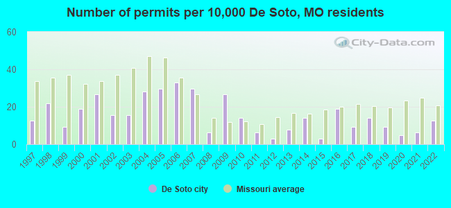
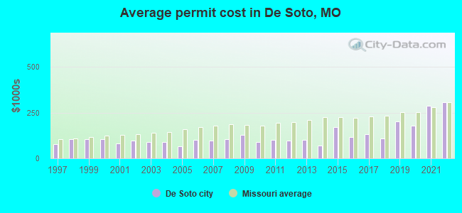
Single-family new house construction building permits:
- 2022: 8 buildings, average cost: $305,000
- 2021: 4 buildings, average cost: $285,000
- 2020: 3 buildings, average cost: $178,300
- 2019: 6 buildings, average cost: $200,200
- 2018: 9 buildings, average cost: $107,800
- 2017: 6 buildings, average cost: $130,000
- 2016: 12 buildings, average cost: $115,900
- 2015: 2 buildings, average cost: $172,000
- 2014: 9 buildings, average cost: $71,400
- 2013: 5 buildings, average cost: $98,600
- 2012: 2 buildings, average cost: $95,000
- 2011: 4 buildings, average cost: $101,300
- 2010: 9 buildings, average cost: $88,700
- 2009: 17 buildings, average cost: $126,500
- 2008: 4 buildings, average cost: $103,800
- 2007: 19 buildings, average cost: $95,000
- 2006: 21 buildings, average cost: $99,500
- 2005: 19 buildings, average cost: $66,100
- 2004: 18 buildings, average cost: $89,000
- 2003: 10 buildings, average cost: $87,600
- 2002: 10 buildings, average cost: $95,300
- 2001: 17 buildings, average cost: $81,500
- 2000: 12 buildings, average cost: $104,700
- 1999: 6 buildings, average cost: $102,800
- 1998: 14 buildings, average cost: $105,700
- 1997: 8 buildings, average cost: $76,300
| Here: | 2.6% |
| Missouri: | 2.8% |
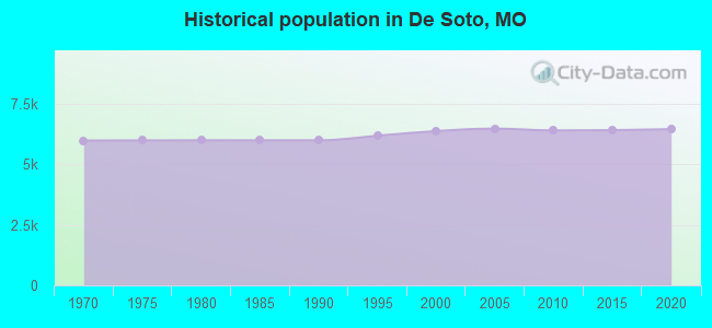
Population change in the 1990s: +280 (+4.6%).
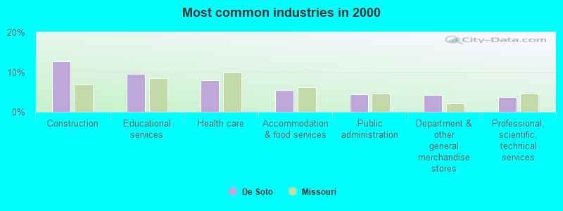
- Construction (12.8%)
- Educational services (9.6%)
- Health care (8.0%)
- Accommodation & food services (5.5%)
- Public administration (4.4%)
- Department & other general merchandise stores (4.3%)
- Professional, scientific, technical services (3.8%)
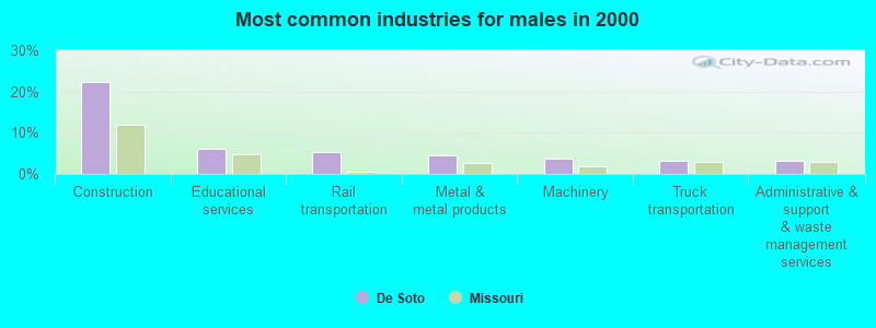
- Construction (22.2%)
- Educational services (6.0%)
- Rail transportation (5.2%)
- Metal & metal products (4.6%)
- Machinery (3.7%)
- Truck transportation (3.3%)
- Administrative & support & waste management services (3.2%)
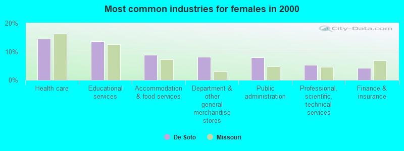
- Health care (14.5%)
- Educational services (13.7%)
- Accommodation & food services (8.9%)
- Department & other general merchandise stores (8.1%)
- Public administration (8.0%)
- Professional, scientific, technical services (5.3%)
- Finance & insurance (4.2%)
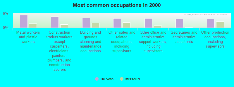
- Metal workers and plastic workers (5.3%)
- Construction traders workers except carpenters, electricians, painters, plumbers, and construction laborers (4.6%)
- Building and grounds cleaning and maintenance occupations (4.0%)
- Other sales and related occupations, including supervisors (3.9%)
- Other office and administrative support workers, including supervisors (3.9%)
- Secretaries and administrative assistants (3.7%)
- Other production occupations, including supervisors (3.7%)
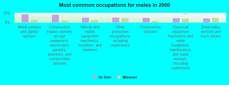
- Metal workers and plastic workers (9.0%)
- Construction traders workers except carpenters, electricians, painters, plumbers, and construction laborers (8.6%)
- Vehicle and mobile equipment mechanics, installers, and repairers (5.4%)
- Other production occupations, including supervisors (5.4%)
- Construction laborers (5.2%)
- Electrical equipment mechanics and other installation, maintenance, and repair workers, including supervisors (4.7%)
- Driver/sales workers and truck drivers (4.4%)
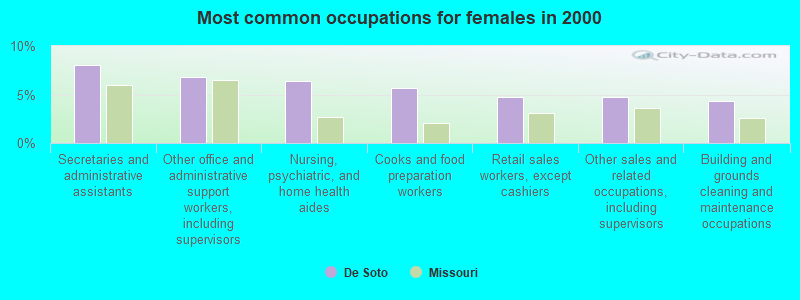
- Secretaries and administrative assistants (8.1%)
- Other office and administrative support workers, including supervisors (6.8%)
- Nursing, psychiatric, and home health aides (6.4%)
- Cooks and food preparation workers (5.7%)
- Retail sales workers, except cashiers (4.8%)
- Other sales and related occupations, including supervisors (4.7%)
- Building and grounds cleaning and maintenance occupations (4.3%)
Average climate in De Soto, Missouri
Based on data reported by over 4,000 weather stations


|
|

(lower is better)
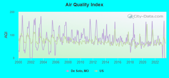
Air Quality Index (AQI) level in 2022 was 70.4. This is about average.
| City: | 70.4 |
| U.S.: | 72.6 |
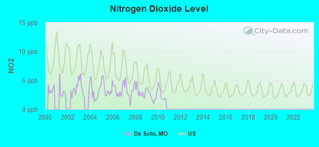
Nitrogen Dioxide (NO2) [ppb] level in 2010 was 2.53. This is significantly better than average. Closest monitor was 18.1 miles away from the city center.
| City: | 2.53 |
| U.S.: | 5.11 |
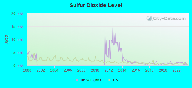
Sulfur Dioxide (SO2) [ppb] level in 2022 was 1.04. This is significantly better than average. Closest monitor was 11.8 miles away from the city center.
| City: | 1.04 |
| U.S.: | 1.51 |
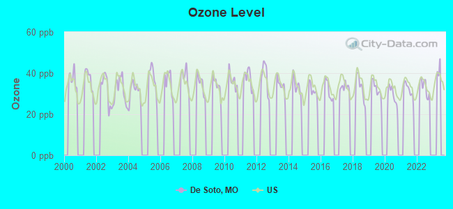
Ozone [ppb] level in 2022 was 33.2. This is about average. Closest monitor was 18.1 miles away from the city center.
| City: | 33.2 |
| U.S.: | 33.3 |
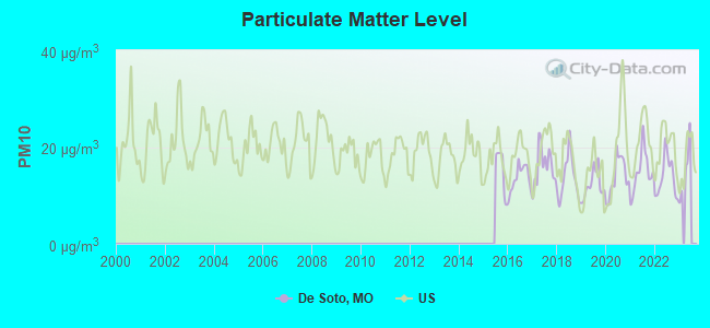
Particulate Matter (PM10) [µg/m3] level in 2022 was 13.8. This is better than average. Closest monitor was 13.1 miles away from the city center.
| City: | 13.8 |
| U.S.: | 19.2 |
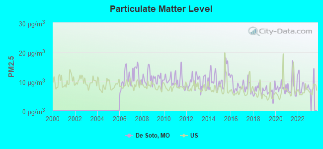
Particulate Matter (PM2.5) [µg/m3] level in 2022 was 8.73. This is about average. Closest monitor was 23.1 miles away from the city center.
| City: | 8.73 |
| U.S.: | 8.11 |
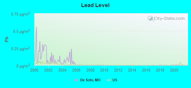
Lead (Pb) [µg/m3] level in 2005 was 0.0787. This is significantly worse than average. Closest monitor was 12.0 miles away from the city center.
| City: | 0.0787 |
| U.S.: | 0.0093 |
Tornado activity:
De Soto-area historical tornado activity is near Missouri state average. It is 70% greater than the overall U.S. average.
On 6/22/1969, a category F4 (max. wind speeds 207-260 mph) tornado 13.5 miles away from the De Soto city center killed 2 people and injured 22 people and caused between $500,000 and $5,000,000 in damages.
On 12/21/1967, a category F4 tornado 16.8 miles away from the city center killed 3 people and injured 52 people and caused between $500,000 and $5,000,000 in damages.
Earthquake activity:
De Soto-area historical earthquake activity is significantly above Missouri state average. It is 360% greater than the overall U.S. average.On 4/18/2008 at 09:36:59, a magnitude 5.4 (5.1 MB, 4.8 MS, 5.4 MW, 5.2 MW, Class: Moderate, Intensity: VI - VII) earthquake occurred 146.6 miles away from the city center
On 9/26/1990 at 13:18:51, a magnitude 5.0 (4.7 MB, 4.8 LG, 5.0 LG, Depth: 7.7 mi) earthquake occurred 87.6 miles away from De Soto center
On 4/18/2008 at 09:36:59, a magnitude 5.2 (5.2 MW, Depth: 8.9 mi) earthquake occurred 146.6 miles away from the city center
On 5/4/1991 at 01:18:54, a magnitude 5.0 (4.4 MB, 4.6 LG, 5.0 LG, Depth: 3.1 mi) earthquake occurred 116.3 miles away from De Soto center
On 6/10/1987 at 23:48:54, a magnitude 5.1 (4.9 MB, 4.4 MS, 4.6 MS, 5.1 LG) earthquake occurred 152.2 miles away from the city center
On 6/18/2002 at 17:37:15, a magnitude 5.0 (4.3 MB, 4.6 MW, 5.0 LG) earthquake occurred 151.6 miles away from De Soto center
Magnitude types: regional Lg-wave magnitude (LG), body-wave magnitude (MB), surface-wave magnitude (MS), moment magnitude (MW)
Natural disasters:
The number of natural disasters in Jefferson County (27) is a lot greater than the US average (15).Major Disasters (Presidential) Declared: 16
Emergencies Declared: 7
Causes of natural disasters: Storms: 19, Floods: 18, Tornadoes: 15, Winds: 4, Winter Storms: 3, Drought: 1, Flash Flood: 1, Heavy Rain: 1, Hurricane: 1, Other: 1 (Note: some incidents may be assigned to more than one category).
Hospitals and medical centers in De Soto:
Colleges/universities with over 2000 students nearest to De Soto:
- Jefferson College (about 9 miles; Hillsboro, MO; Full-time enrollment: 3,975)
- Mineral Area College (about 21 miles; Park Hills, MO; FT enrollment: 2,837)
- East Central College (about 31 miles; Union, MO; FT enrollment: 2,810)
- Webster University (about 34 miles; Saint Louis, MO; FT enrollment: 12,406)
- Maryville University of Saint Louis (about 36 miles; Saint Louis, MO; FT enrollment: 3,651)
- Missouri Baptist University (about 36 miles; Saint Louis, MO; FT enrollment: 2,898)
- Washington University in St Louis (about 38 miles; Saint Louis, MO; FT enrollment: 10,823)
Public high school in De Soto:
- DESOTO SR. HIGH (Students: 896, Location: 815 AMVETS DR, Grades: 9-12)
Public elementary/middle schools in De Soto:
- ATHENA ELEM. (Students: 635, Location: 3775 ATHENA SCHOOL RD, Grades: KG-6)
- DESOTO JR. HIGH (Students: 437, Location: 731 AMVETS DR, Grades: 7-8)
- SUNRISE ELEM. (Students: 351, Location: 4485 SUNRISE SCHOOL RD, Grades: PK-8)
- VINELAND ELEM. (Students: 328, Location: 650 VINELAND SCHOOL RD, Grades: KG-6)
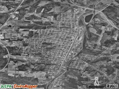
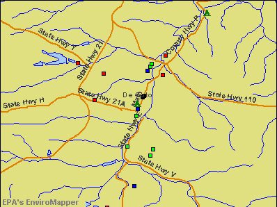
Points of interest:
Notable locations in De Soto: DeSoto Wastewater Treatment Plant (A), City of De Soto Fire and Rescue Station 1 Headquarters (B), De Soto Rural Fire Protection District Station 1 Headquarters (C), City of De Soto Fire and Rescue Station 2 (D). Display/hide their locations on the map
Churches in De Soto include: Redeemer Church (A), DeSoto Community Church of God (B). Display/hide their locations on the map
Cemeteries: Calvary Cemetery (1), Woodlawn Memorial Park (2). Display/hide their locations on the map
Reservoir: Hickory Hills Golf Club Lake (A). Display/hide its location on the map
Streams, rivers, and creeks: Tanyard Branch (A), Ball Branch (B), Whitehead Creek (C), Fritz Creek (D), Falling Rock Branch (E). Display/hide their locations on the map
Parks in De Soto include: Walther Park (1), Joachim Park (2), Ritcher Park (3), Spross Park (4). Display/hide their locations on the map
Tourist attraction: Libraries Public - Desoto (Cultural Attractions- Events- & Facilities; 712 South Main Street).
Hotels: Elks Lodge 689 (Clark Street & Highway 21), Jefferson Square Inn (Highway 21 & N H), Elks Auxiliary (1520 Clarke Street).
Court: Desoto-City - Water Dept- Finance Office- Municipal Court- City Man (17 Boyd Street).
Birthplace of: Jay Nixon - Politician, Rod Jetton - Politician, Fred Blank - Baseball player.
Drinking water stations with addresses in De Soto and their reported violations in the past:
DESOTO (Address: 17 BOYD ST , Population served: 7,500, Groundwater):Past health violations:BAISCH NURSING HOME (Population served: 189, Groundwater):Past monitoring violations:
- MCL, Monthly (TCR) - In DEC-2005, Contaminant: Coliform. Follow-up actions: St Public Notif requested (JAN-20-2006), St Violation/Reminder Notice (JAN-20-2006), St Public Notif received (JAN-25-2006), St Compliance achieved (JAN-22-2014)
- One minor monitoring violation
Past monitoring violations:BRIARWOOD UTILITIES (Population served: 160, Groundwater):
- One minor monitoring violation
- 3 regular monitoring violations
Past monitoring violations:PRO STOP (Population served: 50, Groundwater):
- Follow-up Or Routine LCR Tap M/R - In OCT-01-2008, Contaminant: Lead and Copper Rule. Follow-up actions: St Compliance achieved (JUN-12-2009)
- Initial Tap Sampling for Pb and Cu - In JAN-01-2007, Contaminant: Lead and Copper Rule. Follow-up actions: St Compliance achieved (NOV-07-2007), St Public Notif requested (MAR-03-2008)
- One routine major monitoring violation
Past health violations:Past monitoring violations:
- MCL, Monthly (TCR) - In MAY-2012, Contaminant: Coliform. Follow-up actions: St Public Notif requested (JUN-15-2012), St Violation/Reminder Notice (JUN-15-2012), St Public Notif received (JUL-30-2012), St Compliance achieved (MAY-20-2013)
- MCL, Monthly (TCR) - In DEC-2010, Contaminant: Coliform. Follow-up actions: St Public Notif requested (DEC-30-2010), St Violation/Reminder Notice (DEC-30-2010), St Compliance achieved (MAY-04-2011), St Public Notif received (JUL-30-2012)
- MCL, Monthly (TCR) - In NOV-2010, Contaminant: Coliform. Follow-up actions: St Public Notif requested (DEC-07-2010), St Violation/Reminder Notice (DEC-07-2010), St Compliance achieved (MAY-04-2011), St Public Notif received (JUL-30-2012)
- MCL, Monthly (TCR) - In DEC-2009, Contaminant: Coliform. Follow-up actions: St Public Notif requested (JAN-06-2010), St Violation/Reminder Notice (JAN-06-2010), St Compliance achieved (SEP-30-2010), St Public Notif received (JUL-30-2012)
- MCL, Monthly (TCR) - In OCT-2009, Contaminant: Coliform. Follow-up actions: St Public Notif requested (NOV-24-2009), St Violation/Reminder Notice (NOV-24-2009), St Compliance achieved (SEP-30-2010), St Public Notif received (JUL-30-2012)
- MCL, Monthly (TCR) - In NOV-2005, Contaminant: Coliform. Follow-up actions: St Violation/Reminder Notice (DEC-06-2005), St Public Notif requested (DEC-06-2005), St Public Notif issued (AUG-24-2007), St Public Notif received (JUL-30-2012), St Compliance achieved (JAN-22-2014)
- Monitoring, Source Water (GWR) - In DEC-01-2012, Contaminant: E. COLI. Follow-up actions: St Public Notif requested (DEC-21-2012), St Violation/Reminder Notice (DEC-21-2012), St Compliance achieved (MAY-20-2013)
- Monitoring, Repeat Major (TCR) - In NOV-2012, Contaminant: Coliform (TCR). Follow-up actions: St Public Notif requested (DEC-21-2012), St Violation/Reminder Notice (DEC-21-2012), St Compliance achieved (MAY-20-2013)
- Monitoring, Source Water (GWR) - In NOV-01-2012, Contaminant: E. COLI. Follow-up actions: St Public Notif requested (NOV-19-2012), St Violation/Reminder Notice (NOV-19-2012), St Compliance achieved (MAY-20-2013)
- Monitoring, Repeat Major (TCR) - In OCT-2012, Contaminant: Coliform (TCR). Follow-up actions: St Public Notif requested (NOV-28-2012), St Violation/Reminder Notice (NOV-28-2012), St Compliance achieved (MAY-20-2013)
- Monitoring, Repeat Major (TCR) - In AUG-2011, Contaminant: Coliform (TCR). Follow-up actions: St Public Notif requested (SEP-22-2011), St Violation/Reminder Notice (SEP-22-2011), St Compliance achieved (JAN-31-2012), St Public Notif received (JUL-30-2012)
- 14 routine major monitoring violations
- 5 minor monitoring violations
- 3 regular monitoring violations
- 3 other older monitoring violations
| This city: | 2.4 people |
| Missouri: | 2.5 people |
| This city: | 62.1% |
| Whole state: | 65.3% |
| This city: | 9.5% |
| Whole state: | 6.7% |
Likely homosexual households (counted as self-reported same-sex unmarried-partner households)
- Lesbian couples: 0.3% of all households
- Gay men: 0.2% of all households
12 people in residential treatment centers for adults in 2010
People in group quarters in De Soto in 2000:
- 118 people in nursing homes
- 75 people in other noninstitutional group quarters
- 26 people in other nonhousehold living situations
Banks with branches in De Soto (2011 data):
- PNC Bank, National Association: Rock Road Branch at 2000 Rock Road, branch established on 1976/10/15; Desoto Branch at 224 South Main Street, branch established on 1967/12/09. Info updated 2012/03/20: Bank assets: $263,309.6 mil, Deposits: $197,343.0 mil, headquarters in Wilmington, DE, positive income, Commercial Lending Specialization, 3085 total offices, Holding Company: Pnc Financial Services Group, Inc., The
- First State Community Bank: Desoto Branch at Plaza Square, branch established on 1962/07/02; Desoto Branch - 2 at 1801 Old Boyd Street, branch established on 2006/05/15. Info updated 2011/01/03: Bank assets: $1,303.2 mil, Deposits: $1,092.4 mil, headquarters in Farmington, MO, positive income, Commercial Lending Specialization, 34 total offices, Holding Company: First State Bancshares, Inc.
- Southern Commercial Bank: Desoto Branch at 2101 Rock Road, branch established on 2000/04/05. Info updated 2010/07/14: Bank assets: $528.0 mil, Deposits: $457.6 mil, headquarters in Saint Louis, MO, negative income in the last year, Commercial Lending Specialization, 10 total offices, Holding Company: Southern Bancshares Corp.
- Bank of America, National Association: De Soto Branch at 406 South Main Street, branch established on 1898/01/01. Info updated 2009/11/18: Bank assets: $1,451,969.3 mil, Deposits: $1,077,176.8 mil, headquarters in Charlotte, NC, positive income, 5782 total offices, Holding Company: Bank Of America Corporation
- Eagle Bank and Trust Company of Missouri: 121 Jefferson Square at State Road 21, branch established on 1996/07/10. Info updated 2012/02/21: Bank assets: $836.9 mil, Deposits: $681.2 mil, headquarters in Hillsboro, MO, positive income, Commercial Lending Specialization, 17 total offices, Holding Company: Jefferson County Bancshares, Incorporated
For population 15 years and over in De Soto:
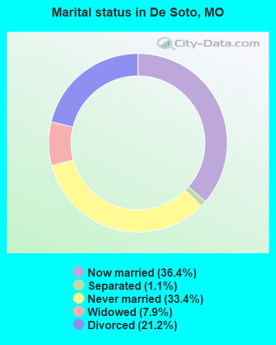
- Never married: 33.4%
- Now married: 36.4%
- Separated: 1.1%
- Widowed: 7.9%
- Divorced: 21.2%
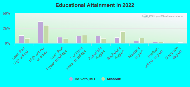
For population 25 years and over in De Soto:
- High school or higher: 87.0%
- Bachelor's degree or higher: 13.4%
- Graduate or professional degree: 4.8%
- Unemployed: 8.7%
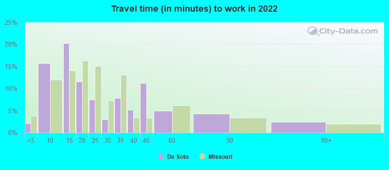
- Mean travel time to work (commute): 32.0 minutes
| Here: | 10.0 |
| Missouri average: | 11.1 |
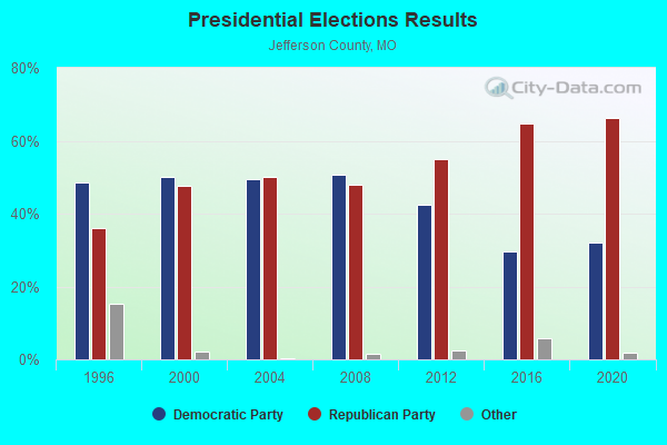

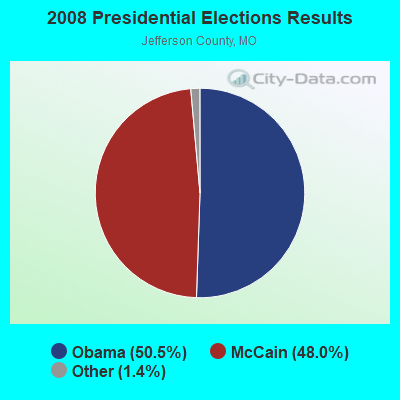


Graphs represent county-level data. Detailed 2008 Election Results
Religion statistics for De Soto, MO (based on Jefferson County data)
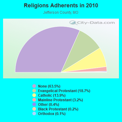
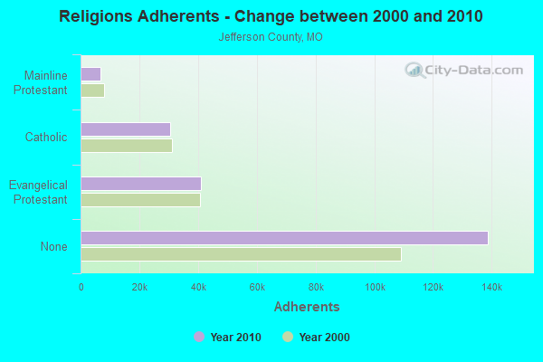
| Religion | Adherents | Congregations |
|---|---|---|
| Evangelical Protestant | 40,846 | 107 |
| Catholic | 30,495 | 11 |
| Mainline Protestant | 6,917 | 31 |
| Other | 925 | 9 |
| Black Protestant | 496 | 3 |
| Orthodox | 260 | 1 |
| None | 138,794 | - |
Food Environment Statistics:
| This county: | 1.07 / 10,000 pop. |
| Missouri: | 1.88 / 10,000 pop. |
| Here: | 0.05 / 10,000 pop. |
| Missouri: | 0.18 / 10,000 pop. |
| Jefferson County: | 0.70 / 10,000 pop. |
| Missouri: | 0.60 / 10,000 pop. |
| Jefferson County: | 3.66 / 10,000 pop. |
| Missouri: | 4.34 / 10,000 pop. |
| Jefferson County: | 4.40 / 10,000 pop. |
| State: | 7.37 / 10,000 pop. |
| Here: | 9.1% |
| State: | 8.8% |
| Jefferson County: | 29.5% |
| State: | 29.6% |
| This county: | 14.5% |
| State: | 13.5% |
Health and Nutrition:
| Here: | 49.8% |
| Missouri: | 50.9% |
| De Soto: | 47.4% |
| State: | 48.6% |
| De Soto: | 29.7 |
| Missouri: | 28.7 |
| De Soto: | 15.1% |
| Missouri: | 20.6% |
| Here: | 11.3% |
| State: | 10.1% |
| De Soto: | 6.6 |
| Missouri: | 6.8 |
| This city: | 37.0% |
| Missouri: | 34.3% |
| De Soto: | 56.1% |
| Missouri: | 57.5% |
| De Soto: | 82.5% |
| Missouri: | 79.3% |
More about Health and Nutrition of De Soto, MO Residents
| Local government employment and payroll (March 2022) | |||||
| Function | Full-time employees | Monthly full-time payroll | Average yearly full-time wage | Part-time employees | Monthly part-time payroll |
|---|---|---|---|---|---|
| Police Protection - Officers | 17 | $76,071 | $53,697 | 0 | $0 |
| Police - Other | 9 | $27,168 | $36,224 | 0 | $0 |
| Firefighters | 8 | $34,371 | $51,557 | 5 | $481 |
| Streets and Highways | 6 | $23,220 | $46,440 | 0 | $0 |
| Water Supply | 5 | $19,241 | $46,178 | 0 | $0 |
| Financial Administration | 4 | $12,587 | $37,761 | 0 | $0 |
| Other Government Administration | 3 | $15,425 | $61,700 | 5 | $2,000 |
| Sewerage | 1 | $4,492 | $53,904 | 0 | $0 |
| Parks and Recreation | 1 | $2,873 | $34,476 | 0 | $0 |
| Other and Unallocable | 1 | $3,924 | $47,088 | 0 | $0 |
| Totals for Government | 55 | $219,373 | $47,863 | 10 | $2,481 |
De Soto government finances - Expenditure in 2021 (per resident):
- Construction - Regular Highways: $383,000 ($59.37)
- Current Operations - Police Protection: $1,339,000 ($207.56)
Water Utilities: $1,213,000 ($188.03)
Parks and Recreation: $903,000 ($139.98)
Financial Administration: $590,000 ($91.46)
Sewerage: $586,000 ($90.84)
Local Fire Protection: $569,000 ($88.20)
Regular Highways: $461,000 ($71.46)
Solid Waste Management: $281,000 ($43.56)
Protective Inspection and Regulation - Other: $88,000 ($13.64)
Judicial and Legal Services: $28,000 ($4.34)
Central Staff Services: $3,000 ($0.47)
- Water Utilities - Interest on Debt: $11,000 ($1.71)
De Soto government finances - Revenue in 2021 (per resident):
- Charges - Sewerage: $586,000 ($90.84)
Solid Waste Management: $434,000 ($67.28)
Parks and Recreation: $226,000 ($35.03)
- Local Intergovernmental - Highways: $191,000 ($29.61)
- Miscellaneous - Interest Earnings: $163,000 ($25.27)
Fines and Forfeits: $35,000 ($5.43)
- Revenue - Water Utilities: $1,308,000 ($202.76)
- State Intergovernmental - Water Utilities: $538,000 ($83.40)
Highways: $125,000 ($19.38)
- Tax - General Sales and Gross Receipts: $4,750,000 ($736.32)
Public Utilities Sales: $875,000 ($135.64)
Property: $465,000 ($72.08)
Occupation and Business License - Other: $17,000 ($2.64)
Alcoholic Beverage License: $11,000 ($1.71)
De Soto government finances - Debt in 2021 (per resident):
- Long Term Debt - Beginning Outstanding - Unspecified Public Purpose: $2,610,000 ($404.59)
Outstanding Unspecified Public Purpose: $2,031,000 ($314.83)
Retired Unspecified Public Purpose: $579,000 ($89.75)
Retired Nonguaranteed - Public Debt for Private Purpose: $41,000 ($6.36)
Beginning Outstanding - Public Debt for Private Purpose: $41,000 ($6.36)
De Soto government finances - Cash and Securities in 2021 (per resident):
- Other Funds - Cash and Securities: $8,193,000 ($1270.04)
| Businesses in De Soto, MO | ||||
| Name | Count | Name | Count | |
|---|---|---|---|---|
| Ace Hardware | 1 | Pizza Hut | 1 | |
| AutoZone | 1 | RadioShack | 1 | |
| Dairy Queen | 1 | SONIC Drive-In | 1 | |
| FedEx | 1 | Subway | 1 | |
| Ford | 1 | T-Mobile | 1 | |
| H&R Block | 1 | True Value | 1 | |
| Hardee's | 1 | U-Haul | 1 | |
| KFC | 1 | UPS | 2 | |
| La-Z-Boy | 1 | Walgreens | 1 | |
| McDonald's | 1 | Walmart | 1 | |
| New Balance | 1 | |||
Strongest AM radio stations in De Soto:
- KMOX (1120 AM; 50 kW; ST. LOUIS, MO; Owner: INFINITY BROADCASTING OPERATIONS, INC.)
- KXEN (1010 AM; 50 kW; FESTUS-ST. LOUIS, MO; Owner: BDJ RADIO ENTERPRISES, LLC)
- WSDZ (1260 AM; 20 kW; BELLEVILLE, IL)
- KJFF (1400 AM; 1 kW; FESTUS, MO; Owner: KREI, INC.)
- KTRS (550 AM; 5 kW; ST. LOUIS, MO; Owner: KTRS-AM LICENSE, L.L.C.)
- KFUO (850 AM; 5 kW; CLAYTON, MO; Owner: LUTHERAN CHURCH-MISSOURI SYNOD)
- KJSL (630 AM; 5 kW; ST. LOUIS, MO; Owner: WMUZ RADIO, INC.)
- KRFT (1190 AM; 10 kW; DE SOTO, MO; Owner: ALL SPORTS RADIO, LLC)
- KSLG (1380 AM; 5 kW; ST. LOUIS, MO; Owner: NEW HORIZON 7TH-DAY CHRISTIAN CHURCH, INC.)
- WRTH (1430 AM; 5 kW; ST. LOUIS, MO)
- KSIV (1320 AM; 5 kW; CLAYTON, MO; Owner: BOTT COMMUNICATIONS, INC.)
- KFMO (1240 AM; 1 kW; FLAT RIVER, MO; Owner: M. K. S. BROADCASTING, INC.)
- KREI (800 AM; 1 kW; FARMINGTON, MO; Owner: KREI, INC.)
Strongest FM radio stations in De Soto:
- KPNT (105.7 FM; ST. GENEVIEVE, MO; Owner: EMMIS RADIO LICENSE CORPORATION)
- KDJR (100.1 FM; DE SOTO, MO; Owner: KDJR RADIO, INC.)
- KTBJ (89.3 FM; FESTUS, MO; Owner: CSN INTERNATIONAL)
- KNLH (89.5 FM; CEDAR HILL, MO; Owner: NEW LIFE EVANGELISTIC CENTER, INC.)
- KNSX (93.3 FM; STEELVILLE, MO; Owner: TWENTY-ONE SOUND COMMUNICATIONS, INC)
- KDHX (88.1 FM; ST. LOUIS, MO; Owner: DOUBLE HELIX CORPORATION)
- WIL-FM (92.3 FM; ST. LOUIS, MO; Owner: BONNEVILLE HOLDING COMPANY)
- KHZR (97.7 FM; POTOSI, MO; Owner: FOUR HIM ENTERPRISES, L.L.C.)
- KTJJ (98.5 FM; FARMINGTON, MO; Owner: KREI, INC.)
- KSD (93.7 FM; ST. LOUIS, MO; Owner: CITICASTERS LICENSES, L.P.)
- KSLZ (107.7 FM; ST. LOUIS, MO; Owner: CITICASTERS LICENSES, L.P.)
- KFUO-FM (99.1 FM; CLAYTON, MO; Owner: THE LUTHERAN CHURCH-MISSOURI SYNOD)
- KYKY (98.1 FM; ST. LOUIS, MO; Owner: INFINITY RADIO SUBSIDIARY OPERATIONS INC.)
- WSSM (106.5 FM; GRANITE CITY, IL; Owner: BONNEVILLE HOLDING COMPANY)
- KSHE (94.7 FM; CRESTWOOD, MO; Owner: EMMIS RADIO LICENSE CORPORATION)
- KDBB (104.3 FM; BONNE TERRE, MO; Owner: MKS BROADCASTING, INC.)
- KLOU (103.3 FM; ST. LOUIS, MO; Owner: CITICASTERS LICENSES, L.P.)
- KWMU (90.7 FM; ST. LOUIS, MO; Owner: THE CURATORS OF THE UNIVERSITY OF MISSOURI)
- KBGM (91.1 FM; PARK HILLS, MO; Owner: AMERICAN FAMILY ASSOCIATION)
- KEZK-FM (102.5 FM; ST. LOUIS, MO; Owner: INFINITY RADIO SUBSIDIARY OPERATIONS INC.)
TV broadcast stations around De Soto:
- KNLC (Channel 24; ST. LOUIS, MO; Owner: NEW LIFE EVANGELISTIC CENTER, INC.)
- WRBU (Channel 46; EAST ST. LOUIS, IL; Owner: ROBERTS BROADCASTING COMPANY)
- KETC (Channel 9; ST. LOUIS, MO; Owner: ST. LOUIS REGIONAL & EDUCATIONAL PUBLIC TV COMMISSION)
- KTVI (Channel 2; ST. LOUIS, MO; Owner: KTVI LICENSE, INC.)
- KSDK (Channel 5; ST. LOUIS, MO; Owner: MULTIMEDIA KSDK, INC.)
- KPLR-TV (Channel 11; ST. LOUIS, MO; Owner: KPLR, INC.)
- KMOV (Channel 4; ST. LOUIS, MO; Owner: KMOV-TV, INC.)
- KDNL-TV (Channel 30; ST. LOUIS, MO; Owner: KDNL LICENSEE, LLC)
- K63FW (Channel 63; JAMESTOWN, MO; Owner: ROGER E. HARDERS)
- K62EG (Channel 62; ST. LOUIS, MO; Owner: ETERNAL FAMILY NETWORK)
- KPTN-LP (Channel 58; ST. LOUIS, MO; Owner: KURT J. PETERSEN)
- K40FF (Channel 40; ST. LOUIS, MO; Owner: EBC ST. LOUIS, INC.)
- K18BT (Channel 18; ST. LOUIS, MO; Owner: TRINITY BROADCASTING NETWORK)
- K65FN (Channel 65; BATESVILLE, AR; Owner: MS COMMUNICATIONS, LLC)

- National Bridge Inventory (NBI) Statistics
- 37Number of bridges
- 344ft / 105mTotal length
- $995,000Total costs
- 108,029Total average daily traffic
- 13,515Total average daily truck traffic
- 192,949Total future (year 2041) average daily traffic
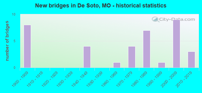
- New bridges - historical statistics
- 81900-1909
- 41940-1949
- 11960-1969
- 41970-1979
- 71980-1989
- 11990-1999
- 92000-2009
- 32010-2019
FCC Registered Antenna Towers:
71 (See the full list of FCC Registered Antenna Towers in De Soto)FCC Registered Broadcast Land Mobile Towers:
3- Lat: 38.138889 Lon: -90.560556, Call Sign: WQAR247,
Assigned Frequencies: 35.0200 MHz, Grant Date: 07/22/2004, Expiration Date: 07/22/2014, Cancellation Date: 09/27/2014, Certifier: Patti Deles, Registrant: Federal Licensing Inc, 1588 Fairfield Rd, Gettysburg, PA 17325, Phone: (717) 334-9262, Fax: (717) 334-6440, Email:
- Lat: 38.137278 Lon: -90.589583, Call Sign: WQSV871,
Assigned Frequencies: 451.537 MHz, 451.662 MHz, 452.037 MHz, 452.137 MHz, 452.287 MHz, Grant Date: 10/24/2023, Expiration Date: 11/25/2033, Certifier: Clint Freeman, Registrant: Wirelessusa, Inc., 148 Weldon Pkwy., Maryland Heights, MO 63043-3102, Phone: (314) 615-3141, Fax: (314) 615-3048, Email:
- Lat: 38.134361 Lon: -90.567167, Call Sign: WQVG297,
Assigned Frequencies: 452.637 MHz, 456.337 MHz, 456.437 MHz, 456.537 MHz, 457.087 MHz, Grant Date: 02/02/2015, Expiration Date: 02/02/2025, Certifier: Clint J Freeman, Registrant: Bearcom Wireless Worldwide, Dallas, TX 75355-9001, Phone: (214) 765-7136, Fax: (214) 355-1714, Email:
FCC Registered Microwave Towers:
14 (See the full list of FCC Registered Microwave Towers in this town)FCC Registered Paging Towers:
1 (See the full list of FCC Registered Paging Towers)FCC Registered Amateur Radio Licenses:
55 (See the full list of FCC Registered Amateur Radio Licenses in De Soto)FAA Registered Aircraft:
6- Aircraft: PIPER PA-23-250 (Category: Land, Engines: 2, Seats: 6, Weight: Up to 12,499 Pounds, Speed: 150 mph), Engine: LYCOMING TI0-540 SER (310 HP) (Reciprocating)
N-Number: 222KH, N222KH, N-222KH, Serial Number: 27-7305097, Year manufactured: 1973, Airworthiness Date: 05/09/1973, Certificate Issue Date: 05/04/2020
Registrant (Co-Owned): Daniel A Raidt, 2824 Abbey Ln, De Soto, MO 63020, Other Owners: Carla M Raidt - Aircraft: GREMMINGER GREG MAGNI M-16 (Category: Land, Seats: 2, Weight: Up to 12,499 Pounds), Engine: BOMBARDIER ROTAX (ALL) (Reciprocating)
N-Number: 316MG, N316MG, N-316MG, Serial Number: 16-06-3474, Year manufactured: 2006, Airworthiness Date: 05/20/2006, Certificate Issue Date: 04/20/2020
Registrant (Individual): Henry J Konzelmann, 4046 Oakbrook Rd, De Soto, MO 63020 - Aircraft: GREG W GREMMINGER MAGNI M22 (Category: Land, Seats: 2, Weight: Up to 12,499 Pounds), Engine: ROTAX 914UL (115 HP) (2 Cycle)
N-Number: 322MG, N322MG, N-322MG, Serial Number: 22138124, Airworthiness Date: 05/19/2015, Certificate Issue Date: 07/24/2020
Registrant (Individual): Henry J Konzelmann, 4046 Oakbrook Rd, De Soto, MO 63020 - Aircraft: CESSNA 172N (Category: Land, Seats: 4, Weight: Up to 12,499 Pounds, Speed: 105 mph), Engine: Reciprocating
N-Number: 5292D, N5292D, N-5292D, Serial Number: 17272497, Airworthiness Date: 03/21/1979, Certificate Issue Date: 08/21/2019
Registrant (Individual): Shawn M Theiss, 3401 Stonehouse Rd, De Soto, MO 63020 - Aircraft: QUAD CITY ULTRALIGHT AIRCRAFT CHALLENGER II (Category: Land, Seats: 2, Weight: Up to 12,499 Pounds), Engine: ROTAX 503ULDCDI (52 HP) (Reciprocating)
N-Number: 8228H, N8228H, N-8228H, Serial Number: CH21000-2022, Year manufactured: 2002, Airworthiness Date: 12/04/2017, Certificate Issue Date: 10/06/2017
Registrant (Individual): Jason A Hale, 12950 Morgans Meadow Rd, De Soto, MO 63020 - Aircraft: LUSCOMBE 8F (Category: Land, Seats: 2, Weight: Up to 12,499 Pounds, Speed: 86 mph), Engine: CONT MOTOR C90 SERIES (95 HP) (Reciprocating)
N-Number: 840B, N840B, N-840B, Serial Number: 6772, Year manufactured: 1950, Airworthiness Date: 07/11/1967, Certificate Issue Date: 10/28/1985
Registrant (Individual): Paul V Graves, 13253 Fox Farm Rd, De Soto, MO 63020
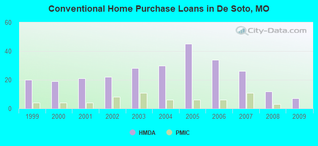
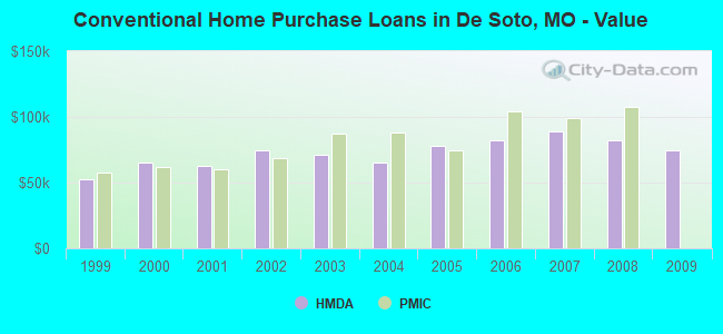
| Home Mortgage Disclosure Act Aggregated Statistics For Year 2009 (Based on 1 partial tract) | ||||||||||
| A) FHA, FSA/RHS & VA Home Purchase Loans | B) Conventional Home Purchase Loans | C) Refinancings | D) Home Improvement Loans | F) Non-occupant Loans on < 5 Family Dwellings (A B C & D) | ||||||
|---|---|---|---|---|---|---|---|---|---|---|
| Number | Average Value | Number | Average Value | Number | Average Value | Number | Average Value | Number | Average Value | |
| LOANS ORIGINATED | 12 | $100,287 | 7 | $74,780 | 29 | $103,639 | 2 | $49,140 | 7 | $83,979 |
| APPLICATIONS APPROVED, NOT ACCEPTED | 0 | $0 | 0 | $0 | 2 | $126,165 | 0 | $0 | 0 | $0 |
| APPLICATIONS DENIED | 3 | $94,690 | 3 | $56,073 | 16 | $116,578 | 4 | $10,168 | 2 | $36,200 |
| APPLICATIONS WITHDRAWN | 1 | $68,400 | 0 | $0 | 12 | $108,837 | 0 | $0 | 1 | $93,660 |
| FILES CLOSED FOR INCOMPLETENESS | 0 | $0 | 0 | $0 | 6 | $114,922 | 0 | $0 | 0 | $0 |
Detailed HMDA statistics for the following Tracts: 7012.00
| Private Mortgage Insurance Companies Aggregated Statistics For Year 2008 (Based on 1 partial tract) | ||||
| A) Conventional Home Purchase Loans | B) Refinancings | |||
|---|---|---|---|---|
| Number | Average Value | Number | Average Value | |
| LOANS ORIGINATED | 3 | $107,527 | 2 | $93,815 |
| APPLICATIONS APPROVED, NOT ACCEPTED | 1 | $97,670 | 1 | $83,190 |
| APPLICATIONS DENIED | 0 | $0 | 0 | $0 |
| APPLICATIONS WITHDRAWN | 0 | $0 | 0 | $0 |
| FILES CLOSED FOR INCOMPLETENESS | 1 | $63,780 | 0 | $0 |
Detailed PMIC statistics for the following Tracts: 7012.00
2002 - 2018 National Fire Incident Reporting System (NFIRS) incidents
- Fire incident types reported to NFIRS in De Soto, MO
- 92755.9%Structure Fires
- 52431.6%Outside Fires
- 17710.7%Mobile Property/Vehicle Fires
- 311.9%Other
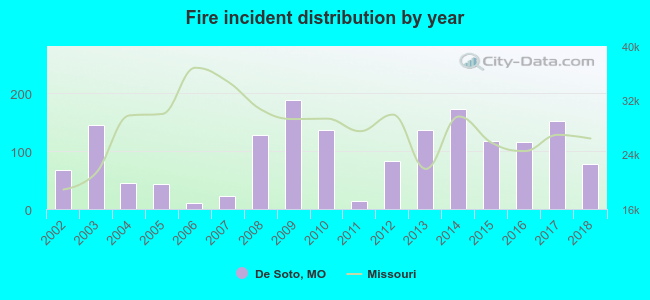 Based on the data from the years 2002 - 2018 the average number of fire incidents per year is 98. The highest number of reported fire incidents - 188 took place in 2009, and the least - 11 in 2006. The data has a growing trend.
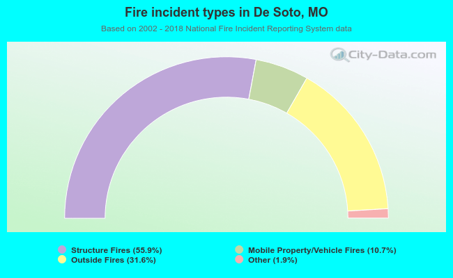 When looking into fire subcategories, the most incidents belonged to: Structure Fires (55.9%), and Outside Fires (31.6%).
- 53.6%Electricity
- 45.1%Utility gas
- 1.3%No fuel used
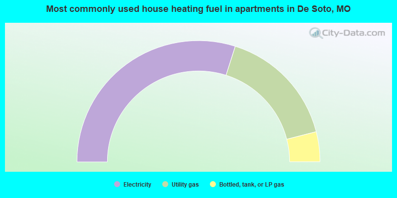
- 59.8%Electricity
- 32.2%Utility gas
- 8.0%Bottled, tank, or LP gas
De Soto compared to Missouri state average:
- Black race population percentage significantly below state average.
- Hispanic race population percentage significantly below state average.
- Foreign-born population percentage significantly below state average.
- Percentage of population with a bachelor's degree or higher below state average.
De Soto on our top lists:
- #35 on the list of "Top 101 cities with largest percentage of females in occupations: healthcare support occupations (population 5,000+)"
- #76 on the list of "Top 101 cities with largest percentage of females in occupations: computer and mathematical occupations (population 5,000+)"
- #79 on the list of "Top 101 cities with the highest percentage of English-only speaking households, population 5,000+"
- #35 on the list of "Top 101 counties with the lowest percentage of residents relocating from foreign countries between 2010 and 2011"
- #53 on the list of "Top 101 counties with the largest increase in the number of deaths per 1000 residents 2000-2006 to 2007-2013 (pop. 50,000+)"
- #63 on the list of "Top 101 counties with the lowest percentage of residents relocating to foreign countries in 2011"
- #73 on the list of "Top 101 counties with the lowest surface withdrawal of fresh water for public supply (pop. 50,000+)"
- #74 on the list of "Top 101 counties with the highest Ozone (1-hour) air pollution readings in 2012 (ppm)"

|
Total of 4 patent applications in 2008-2024.