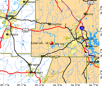
Euharlee, Georgia
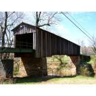
Euharlee: Euharlee Covered Bridge
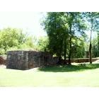
Euharlee: Part of the "OLD GRIST MILL"

Euharlee: EUHARLEE CREEK

Euharlee: Inside the "Grist Mill"

Euharlee: EUHARLEE
- add
your


Submit your own pictures of this city and show them to the world
- OSM Map
- General Map
- Google Map
- MSN Map
Population change since 2000: +33.2%
| Males: 1,977 | |
| Females: 2,296 |
| Median resident age: | 35.3 years |
| Georgia median age: | 37.6 years |
| Euharlee: | $104,891 |
| GA: | $72,837 |
Estimated per capita income in 2022: $38,759 (it was $17,483 in 2000)
Euharlee city income, earnings, and wages data
Estimated median house or condo value in 2022: $249,405 (it was $98,000 in 2000)
| Euharlee: | $249,405 |
| GA: | $297,400 |
Mean prices in 2022: all housing units: $247,232; detached houses: $253,783; mobile homes: $105,709
Median gross rent in 2022: $1,309.
(1.4% for White Non-Hispanic residents, 18.8% for Black residents)
Detailed information about poverty and poor residents in Euharlee, GA
Compare current foreclosures near Euharlee, GA:
| Photo | Address | Area | Beds / Baths | Price | Details |
|---|---|---|---|---|---|

|
#1
4th St
Emerson, GA 30137
|
- sq. feet
|
1 baths 2 beds |
$55,000
|
show details |

|
#2
Valley Trl SE
Acworth, GA 30101
|
1,412 sq. feet
|
2 baths 3 beds |
$329,900
|
show details |

|
#3
4th St
Emerson, GA 30137
|
- sq. feet
|
1 baths 2 beds |
$55,000
|
show details |

|
#4
Horseshow Rd NW
Adairsville, GA 30103
|
1,120 sq. feet
|
2 baths 3 beds |
show details | |

|
#5
Joe Frank Harris Pkwy NW
Cartersville, GA 30120
|
1,679 sq. feet
|
3 baths 4 beds |
show details | |

|
#6
Mayflower Cir
Cartersville, GA 30120
|
1,144 sq. feet
|
2 baths 3 beds |
show details | |

|
#7
Dewey Dr
Adairsville, GA 30103
|
1,391 sq. feet
|
3 baths 4 beds |
show details | |

|
#8
Popham Rd
Taylorsville, GA 30178
|
2,216 sq. feet
|
3 baths 4 beds |
show details | |

|
#9
Hydrangea Chase
Dallas, GA 30132
|
2,996 sq. feet
|
4 baths 5 beds |
show details | |

|
#10
Trailside Dr
Dallas, GA 30157
|
1,522 sq. feet
|
2 baths 3 beds |
show details |
| Photo | Address | Area | Beds / Baths | Price | Details |
|---|---|---|---|---|---|

|
#11
Fieldwood Dr NW
Adairsville, GA 30103
|
2,225 sq. feet
|
2 baths 3 beds |
show details | |

|
#12
Ann Cir SE
Cartersville, GA 30121
|
- sq. feet
|
2 baths 3 beds |
show details | |

|
#13
Buchanan St
Dallas, GA 30132
|
- sq. feet
|
1 baths 3 beds |
show details | |

|
#14
Rockmart Hwy
Cedartown, GA 30125
|
1,356 sq. feet
|
2 baths 3 beds |
show details | |

|
#15
Hamil Ct NW
Cartersville, GA 30120
|
1,736 sq. feet
|
2 baths 3 beds |
show details | |

|
#16
Westminster Dr SW
Cartersville, GA 30120
|
1,154 sq. feet
|
3 baths 4 beds |
show details | |

|
#17
Morris St
Cartersville, GA 30120
|
1,000 sq. feet
|
1 baths 3 beds |
show details | |

|
#18
Evergreen Trl
Cartersville, GA 30121
|
- sq. feet
|
4 baths 8 beds |
show details | |

|
#19
Blacks Bluff Rd SW
Rome, GA 30161
|
2,488 sq. feet
|
1 baths 3 beds |
show details | |

|
#20
Kay Rd NE
White, GA 30184
|
2,517 sq. feet
|
3 baths 4 beds |
show details |
| Photo | Address | Area | Beds / Baths | Price | Details |
|---|---|---|---|---|---|

|
#21
Picaboo Path
Acworth, GA 30101
|
2,788 sq. feet
|
3 baths 3 beds |
show details | |

|
#22
Hunter St
Rockmart, GA 30153
|
1,050 sq. feet
|
1 baths 3 beds |
show details | |

|
#23
Rock Fence Cir SE
Cartersville, GA 30121
|
1,304 sq. feet
|
1 baths 3 beds |
show details | |

|
#24
Lincolnwood Ln
Acworth, GA 30101
|
2,353 sq. feet
|
2 baths 3 beds |
show details | |

|
#25
Mountain View Dr
Rockmart, GA 30153
|
1,958 sq. feet
|
3 baths 3 beds |
show details | |

|
#26
Brookhaven Way
Rockmart, GA 30153
|
1,262 sq. feet
|
2 baths 3 beds |
show details | |

|
#27
Noland St
Adairsville, GA 30103
|
912 sq. feet
|
1 baths 3 beds |
show details | |

|
#28
Hotel St
Adairsville, GA 30103
|
1,536 sq. feet
|
2 baths 3 beds |
show details | |

|
#29
Clear Pass
Adairsville, GA 30103
|
1,324 sq. feet
|
2 baths 3 beds |
show details | |

|
#30
Dewey Dr
Adairsville, GA 30103
|
1,339 sq. feet
|
2 baths 3 beds |
show details |
| Photo | Address | Area | Beds / Baths | Price | Details |
|---|---|---|---|---|---|

|
#31
Brookhaven Dr
Rockmart, GA 30153
|
1,304 sq. feet
|
2 baths 3 beds |
show details | |

|
#32
Oakcrest Dr
Rockmart, GA 30153
|
2,295 sq. feet
|
2 baths 3 beds |
show details | |

|
#33
Collard Valley Rd
Aragon, GA 30104
|
1,104 sq. feet
|
1 baths 3 beds |
show details | |

|
#34
Jack Atkins Rd
Aragon, GA 30104
|
1,320 sq. feet
|
2 baths 3 beds |
show details | |

|
#35
Skyview Dr SE
Acworth, GA 30101
|
2,432 sq. feet
|
2 baths 3 beds |
show details | |

|
#36
Garvey Ln NW
Acworth, GA 30101
|
3,640 sq. feet
|
3 baths 4 beds |
show details | |

|
#37
Abernathy Farm Way
Acworth, GA 30101
|
1,949 sq. feet
|
2 baths 3 beds |
show details | |

|
#38
Dodd Rd
Kingston, GA 30145
|
1,998 sq. feet
|
2 baths 3 beds |
show details | |

|
#39
Fairview Knl
Dallas, GA 30157
|
1,285 sq. feet
|
2 baths 3 beds |
show details | |

|
#40
Muskogee Dr
Dallas, GA 30132
|
1,680 sq. feet
|
2 baths 3 beds |
show details |
| Photo | Address | Area | Beds / Baths | Price | Details |
|---|---|---|---|---|---|

|
#41
Highway 101 N
Rockmart, GA 30153
|
1,782 sq. feet
|
2 baths 3 beds |
show details | |

|
#42
Muskogee Xing
Dallas, GA 30132
|
1,520 sq. feet
|
2 baths 3 beds |
show details | |

|
#43
1st Ave
Rockmart, GA 30153
|
960 sq. feet
|
1 baths 2 beds |
show details | |

|
#44
Fairview Dr
Dallas, GA 30157
|
1,318 sq. feet
|
2 baths 3 beds |
show details | |

|
#45
Sweet Gum Ln SE
Cartersville, GA 30121
|
1,164 sq. feet
|
2 baths 3 beds |
show details | |

|
#46
Lane St
Rockmart, GA 30153
|
1,184 sq. feet
|
1 baths 3 beds |
show details | |

|
#47
Ashford Pt NW
Adairsville, GA 30103
|
1,104 sq. feet
|
2 baths 3 beds |
show details | |

|
#48
Benson Rd
Dallas, GA 30132
|
2,640 sq. feet
|
2 baths 3 beds |
show details | |

|
#49
Apache Dr SE
Acworth, GA 30102
|
1,104 sq. feet
|
2 baths 3 beds |
show details | |

|
Check over 1 million property listings on Foreclosure.com!
|
browse all offers | |||


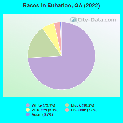
- 3,20273.9%White alone
- 70116.2%Black alone
- 2646.1%Two or more races
- 1232.8%Hispanic
- 300.7%Asian alone
- 10.02%American Indian alone
Races in Euharlee detailed stats: ancestries, foreign born residents, place of birth
According to our research of Georgia and other state lists, there were 2 registered sex offenders living in Euharlee, Georgia as of April 26, 2024.
The ratio of all residents to sex offenders in Euharlee is 2,151 to 1.
The ratio of registered sex offenders to all residents in this city is much lower than the state average.
Type |
2009 |
2010 |
2011 |
2012 |
2013 |
2014 |
2015 |
2016 |
2021 |
2022 |
|---|---|---|---|---|---|---|---|---|---|---|
| Murders (per 100,000) | 0 (0.0) | 0 (0.0) | 0 (0.0) | 0 (0.0) | 0 (0.0) | 0 (0.0) | 1 (23.6) | 0 (0.0) | 0 (0.0) | 0 (0.0) |
| Rapes (per 100,000) | 1 (23.1) | 0 (0.0) | 4 (95.5) | 3 (71.6) | 0 (0.0) | 0 (0.0) | 0 (0.0) | 0 (0.0) | 2 (44.9) | 1 (23.0) |
| Robberies (per 100,000) | 0 (0.0) | 0 (0.0) | 0 (0.0) | 0 (0.0) | 0 (0.0) | 0 (0.0) | 0 (0.0) | 0 (0.0) | 0 (0.0) | 0 (0.0) |
| Assaults (per 100,000) | 7 (161.9) | 0 (0.0) | 10 (238.7) | 3 (71.6) | 1 (24.1) | 107 (2,547) | 19 (449.2) | 5 (116.7) | 3 (67.4) | 0 (0.0) |
| Burglaries (per 100,000) | 5 (115.6) | 3 (72.5) | 23 (548.9) | 13 (310.2) | 13 (312.8) | 149 (3,547) | 20 (472.8) | 10 (233.3) | 2 (44.9) | 2 (46.0) |
| Thefts (per 100,000) | 5 (115.6) | 4 (96.7) | 9 (214.8) | 37 (882.8) | 119 (2,863) | 613 (14,592) | 66 (1,560) | 45 (1,050) | 15 (337.1) | 22 (506.3) |
| Auto thefts (per 100,000) | 0 (0.0) | 0 (0.0) | 6 (143.2) | 2 (47.7) | 8 (192.5) | 26 (618.9) | 4 (94.6) | 2 (46.7) | 2 (44.9) | 0 (0.0) |
| Arson (per 100,000) | 0 (0.0) | 0 (0.0) | 0 (0.0) | 0 (0.0) | 0 (0.0) | 0 (0.0) | 0 (0.0) | 1 (23.3) | 1 (22.5) | 1 (23.0) |
| City-Data.com crime index | 63.6 | 8.9 | 182.6 | 132.4 | 156.6 | 1390.9 | 240.2 | 85.4 | 69.7 | 41.9 |
The City-Data.com crime index weighs serious crimes and violent crimes more heavily. Higher means more crime, U.S. average is 246.1. It adjusts for the number of visitors and daily workers commuting into cities.
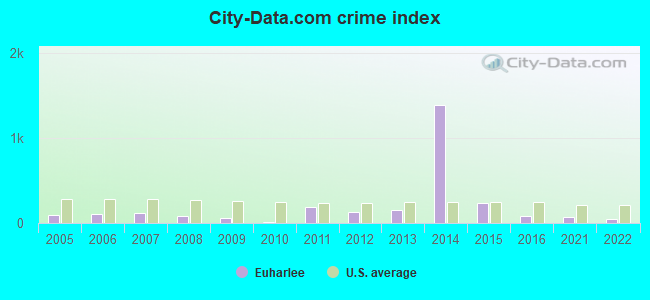
Crime rate in Euharlee detailed stats: murders, rapes, robberies, assaults, burglaries, thefts, arson
Full-time law enforcement employees in 2021, including police officers: 12 (10 officers - 7 male; 3 female).
| Officers per 1,000 residents here: | 2.25 |
| Georgia average: | 2.45 |
 Recent articles from our blog. Our writers, many of them Ph.D. graduates or candidates, create easy-to-read articles on a wide variety of topics.


 | Need No BS advice/recommendations on a safer small town (22 replies) |
| how far north is no longer "Atlanta metro"? (68 replies) |
| Atlanta had the largest urban area growth. (45 replies) |
| Carrollton move...very soon (46 replies) |
| Moving from NYC(Queens) to Rome, GA end of August! (11 replies) |
| What is "Atlanta", the Suburbs, the Exurbs? (25 replies) |
Latest news from Euharlee, GA collected exclusively by city-data.com from local newspapers, TV, and radio stations
Ancestries: American (27.5%), English (12.4%), Irish (10.8%), African (8.1%), German (5.1%), European (3.4%).
Current Local Time: EST time zone
Elevation: 680 feet
Land area: 4.62 square miles.
Population density: 925 people per square mile (low).
39 residents are foreign born
| This city: | 0.9% |
| Georgia: | 10.4% |
Median real estate property taxes paid for housing units with mortgages in 2022: $2,197 (0.8%)
Median real estate property taxes paid for housing units with no mortgage in 2022: $1,719 (0.9%)
Nearest city with pop. 50,000+: Marietta, GA  (26.3 miles , pop. 58,748).
Nearest city with pop. 200,000+: Atlanta, GA (40.7 miles , pop. 416,474).
Nearest city with pop. 1,000,000+: Chicago, IL (552.7 miles , pop. 2,896,016).
Nearest cities:
), ), ), Latitude: 34.15 N, Longitude: 84.94 W
Euharlee, Georgia accommodation & food services, waste management - Economy and Business Data
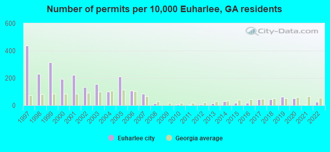
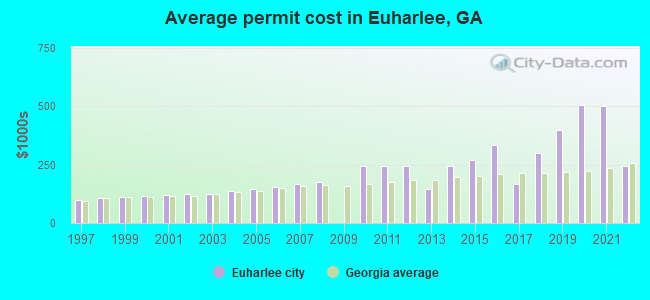
Single-family new house construction building permits:
- 2022: 8 buildings, average cost: $243,500
- 2021: 1 building, cost: $500,000
- 2020: 17 buildings, average cost: $505,900
- 2019: 20 buildings, average cost: $396,900
- 2018: 14 buildings, average cost: $300,000
- 2017: 14 buildings, average cost: $169,300
- 2016: 6 buildings, average cost: $334,800
- 2015: 6 buildings, average cost: $270,700
- 2014: 10 buildings, average cost: $242,100
- 2013: 5 buildings, average cost: $147,000
- 2012: 2 buildings, average cost: $244,500
- 2011: 1 building, cost: $242,500
- 2010: 2 buildings, average cost: $242,500
- 2008: 5 buildings, average cost: $176,400
- 2007: 27 buildings, average cost: $166,700
- 2006: 35 buildings, average cost: $155,800
- 2005: 68 buildings, average cost: $146,200
- 2004: 32 buildings, average cost: $135,800
- 2003: 50 buildings, average cost: $125,600
- 2002: 43 buildings, average cost: $125,900
- 2001: 71 buildings, average cost: $121,000
- 2000: 62 buildings, average cost: $116,700
- 1999: 101 buildings, average cost: $111,800
- 1998: 74 buildings, average cost: $104,900
- 1997: 140 buildings, average cost: $99,900
| Here: | 2.8% |
| Georgia: | 2.9% |
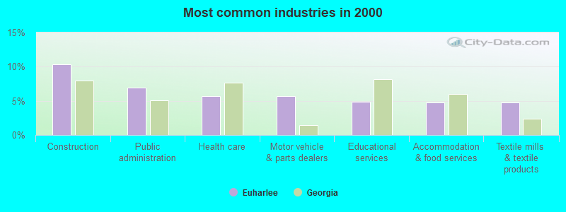
- Construction (10.3%)
- Public administration (7.0%)
- Health care (5.7%)
- Motor vehicle & parts dealers (5.7%)
- Educational services (4.9%)
- Accommodation & food services (4.8%)
- Textile mills & textile products (4.7%)
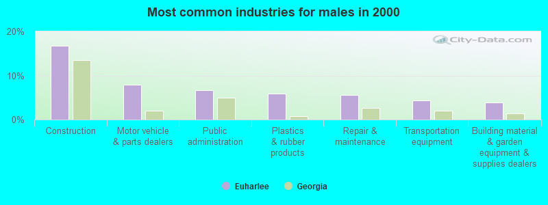
- Construction (16.7%)
- Motor vehicle & parts dealers (7.9%)
- Public administration (6.7%)
- Plastics & rubber products (5.9%)
- Repair & maintenance (5.6%)
- Transportation equipment (4.3%)
- Building material & garden equipment & supplies dealers (3.8%)
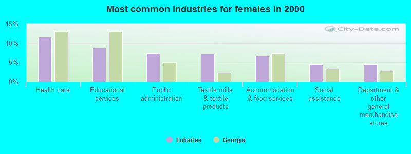
- Health care (11.5%)
- Educational services (8.8%)
- Public administration (7.3%)
- Textile mills & textile products (7.1%)
- Accommodation & food services (6.7%)
- Social assistance (4.6%)
- Department & other general merchandise stores (4.6%)
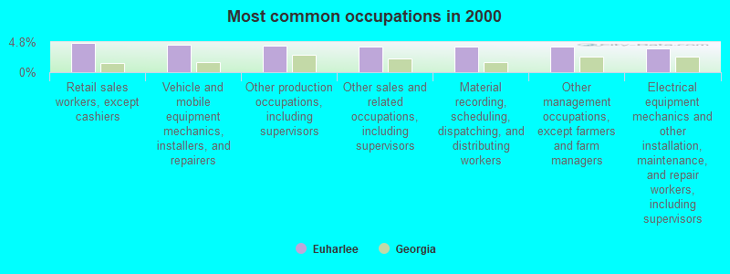
- Retail sales workers, except cashiers (4.7%)
- Vehicle and mobile equipment mechanics, installers, and repairers (4.4%)
- Other production occupations, including supervisors (4.2%)
- Other sales and related occupations, including supervisors (4.1%)
- Material recording, scheduling, dispatching, and distributing workers (4.1%)
- Other management occupations, except farmers and farm managers (4.1%)
- Electrical equipment mechanics and other installation, maintenance, and repair workers, including supervisors (3.8%)
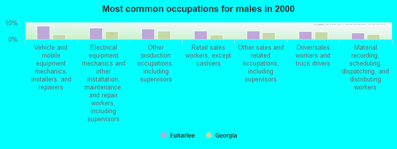
- Vehicle and mobile equipment mechanics, installers, and repairers (8.1%)
- Electrical equipment mechanics and other installation, maintenance, and repair workers, including supervisors (6.9%)
- Other production occupations, including supervisors (6.5%)
- Retail sales workers, except cashiers (5.3%)
- Other sales and related occupations, including supervisors (5.1%)
- Driver/sales workers and truck drivers (4.8%)
- Material recording, scheduling, dispatching, and distributing workers (3.9%)
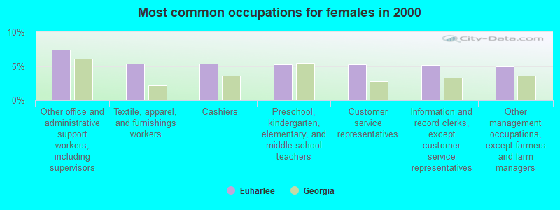
- Other office and administrative support workers, including supervisors (7.4%)
- Textile, apparel, and furnishings workers (5.4%)
- Cashiers (5.4%)
- Preschool, kindergarten, elementary, and middle school teachers (5.3%)
- Customer service representatives (5.3%)
- Information and record clerks, except customer service representatives (5.1%)
- Other management occupations, except farmers and farm managers (5.0%)
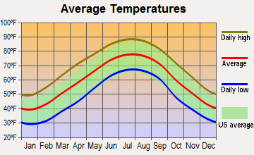
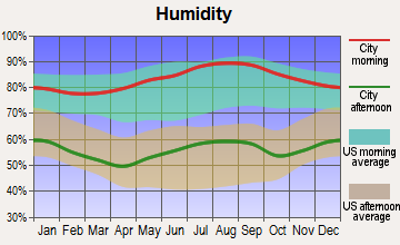
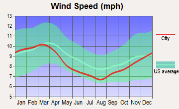
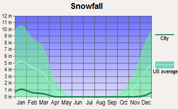
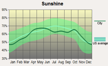
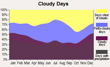
Average climate in Euharlee, Georgia
Based on data reported by over 4,000 weather stations

(lower is better)
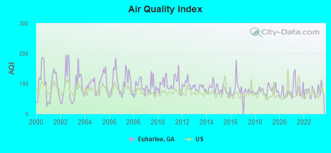
Air Quality Index (AQI) level in 2023 was 77.0. This is about average.
| City: | 77.0 |
| U.S.: | 72.6 |
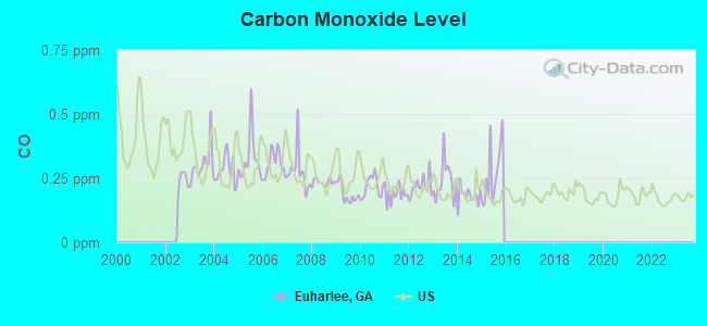
Carbon Monoxide (CO) [ppm] level in 2015 was 0.248. This is about average. Closest monitor was 16.4 miles away from the city center.
| City: | 0.248 |
| U.S.: | 0.251 |
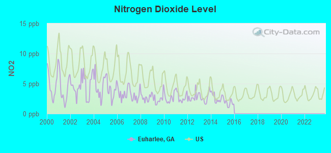
Nitrogen Dioxide (NO2) [ppb] level in 2015 was 1.87. This is significantly better than average. Closest monitor was 15.9 miles away from the city center.
| City: | 1.87 |
| U.S.: | 5.11 |
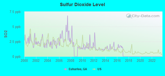
Sulfur Dioxide (SO2) [ppb] level in 2016 was 1.61. This is about average. Closest monitor was 3.3 miles away from the city center.
| City: | 1.61 |
| U.S.: | 1.51 |
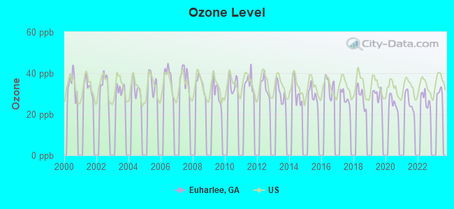
Ozone [ppb] level in 2022 was 27.1. This is better than average. Closest monitor was 15.5 miles away from the city center.
| City: | 27.1 |
| U.S.: | 33.3 |
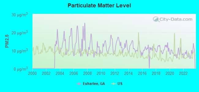
Particulate Matter (PM2.5) [µg/m3] level in 2023 was 9.39. This is about average. Closest monitor was 16.4 miles away from the city center.
| City: | 9.39 |
| U.S.: | 8.11 |
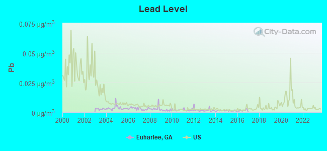
Lead (Pb) [µg/m3] level in 2016 was 0.00153. This is significantly better than average. Closest monitor was 15.9 miles away from the city center.
| City: | 0.00153 |
| U.S.: | 0.00931 |
Tornado activity:
Euharlee-area historical tornado activity is above Georgia state average. It is 83% greater than the overall U.S. average.
On 3/27/1994, a category F4 (max. wind speeds 207-260 mph) tornado 5.5 miles away from the Euharlee city center killed 3 people and injured 20 people and caused between $5,000,000 and $50,000,000 in damages.
On 11/22/1992, a category F4 tornado 21.9 miles away from the city center injured 46 people and caused between $5,000,000 and $50,000,000 in damages.
Earthquake activity:
Euharlee-area historical earthquake activity is significantly above Georgia state average. It is 81% greater than the overall U.S. average.On 4/29/2003 at 08:59:39, a magnitude 4.9 (4.4 MB, 4.6 MW, 4.9 LG, Class: Light, Intensity: IV - V) earthquake occurred 46.3 miles away from the city center
On 4/29/2003 at 08:59:39, a magnitude 4.6 (4.6 MW, Depth: 12.3 mi) earthquake occurred 46.3 miles away from the city center
On 8/2/1974 at 08:52:09, a magnitude 4.9 (4.3 MB, 4.9 LG) earthquake occurred 141.7 miles away from Euharlee center
On 1/18/1999 at 07:00:53, a magnitude 4.8 (4.8 MB, 4.0 LG, Depth: 0.6 mi) earthquake occurred 142.8 miles away from the city center
On 11/30/1973 at 07:48:41, a magnitude 4.7 (4.7 MB, 4.6 ML) earthquake occurred 126.9 miles away from the city center
On 12/12/2018 at 09:14:43, a magnitude 4.4 (4.4 MW, Depth: 4.9 mi) earthquake occurred 102.0 miles away from the city center
Magnitude types: regional Lg-wave magnitude (LG), body-wave magnitude (MB), local magnitude (ML), moment magnitude (MW)
Natural disasters:
The number of natural disasters in Bartow County (14) is near the US average (15).Major Disasters (Presidential) Declared: 9
Emergencies Declared: 4
Causes of natural disasters: Tornadoes: 6, Storms: 5, Floods: 4, Winter Storms: 3, Hurricanes: 2, Winds: 2, Drought: 1, Heavy Rain: 1, Snowfall: 1, Other: 1 (Note: some incidents may be assigned to more than one category).

Hospitals and medical centers near Euharlee:
- CARTERSVILLE MEDICAL CENTER Acute Care Hospitals (about 8 miles away; CARTERSVILLE, GA)
- DSI CARTERSVILLE RENAL CENTER (Dialysis Facility, about 9 miles away; CARTERSVILLE, GA)
- TOWNSEND PARK HEALTH AND REHABILITATION (Nursing Home, about 9 miles away; CARTERSVILLE, GA)
- FIRST AMERICAN HOME CARE OF GA CTRSVIL (Home Health Center, about 9 miles away; CARTERSVILLE, GA)
- CARTERSVILLE HEIGHTS CARE AND REHABILITATION CTR (Nursing Home, about 9 miles away; CARTERSVILLE, GA)
- SPRINGDALE HEALTH CARE CENTER (Nursing Home, about 9 miles away; CARTERSVILLE, GA)
- FMCNA CARTERSVILLE (Dialysis Facility, about 10 miles away; CARTERSVILLE, GA)
Airports located in Euharlee:
- Etowah Fields Airport (02GE) (Runways: 1)
Colleges/universities with over 2000 students nearest to Euharlee:
- Georgia Northwestern Technical College (about 15 miles; Rome, GA; Full-time enrollment: 4,629)
- Georgia Highlands College (about 16 miles; Rome, GA; FT enrollment: 4,071)
- Berry College (about 18 miles; Mount Berry, GA; FT enrollment: 2,102)
- Kennesaw State University (about 22 miles; Kennesaw, GA; FT enrollment: 21,215)
- Chattahoochee Technical College (about 27 miles; Marietta, GA; FT enrollment: 8,173)
- Southern Polytechnic State University (about 28 miles; Marietta, GA; FT enrollment: 5,258)
- West Georgia Technical College (about 35 miles; Waco, GA; FT enrollment: 4,768)
Public elementary/middle schools in Euharlee:
- WOODLAND MIDDLE SCHOOL AT EUHARLEE (Students: 915, Location: 1061 EUHARLEE RD, Grades: 6-8)
- EUHARLEE ELEMENTARY SCHOOL (Students: 859, Location: 1058 EUHARLEE RD, Grades: PK-5)
Points of interest:
Notable location: Bartow County Fire Department Station 3 (A). Display/hide its location on the map
Church in Euharlee: Corinth Church (A). Display/hide its location on the map
Cemeteries: Black Pioneers Cemetery (1), Burge Family Cemetery (2), Euharlee Baptist Church Cemetery (3), Euharlee Presbyterian Church Cemetery (4). Display/hide their locations on the map
Creek: Euharlee Creek (A). Display/hide its location on the map
| This city: | 3.3 people |
| Georgia: | 2.6 people |
| This city: | 86.1% |
| Whole state: | 68.5% |
| This city: | 6.3% |
| Whole state: | 5.9% |
Likely homosexual households (counted as self-reported same-sex unmarried-partner households)
- Lesbian couples: 0.4% of all households
- Gay men: 0.3% of all households
For population 15 years and over in Euharlee:
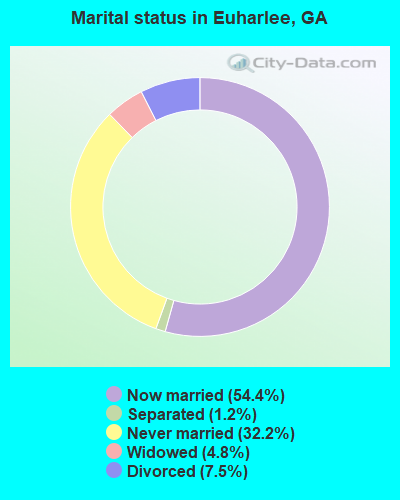
- Never married: 32.2%
- Now married: 54.4%
- Separated: 1.2%
- Widowed: 4.8%
- Divorced: 7.5%
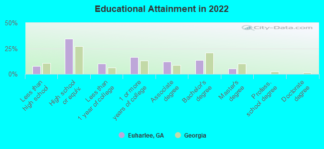
For population 25 years and over in Euharlee:
- High school or higher: 92.1%
- Bachelor's degree or higher: 16.8%
- Graduate or professional degree: 5.2%
- Unemployed: 5.4%
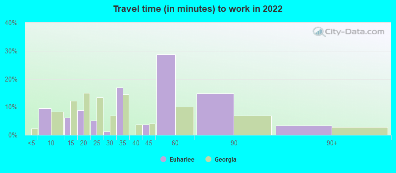
- Mean travel time to work (commute): 26.6 minutes
| Here: | 11.3 |
| Georgia average: | 12.2 |
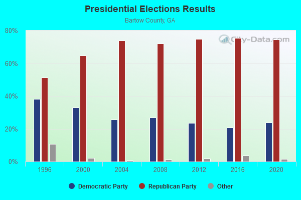
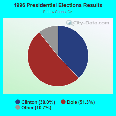
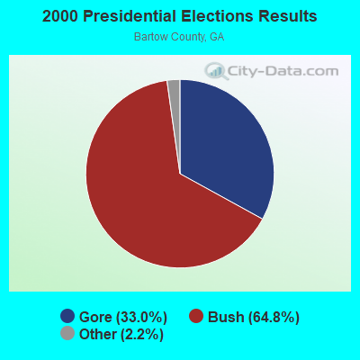
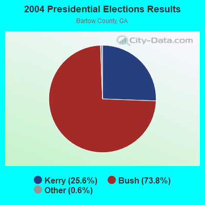
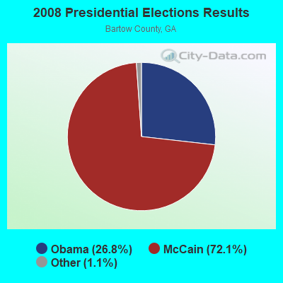
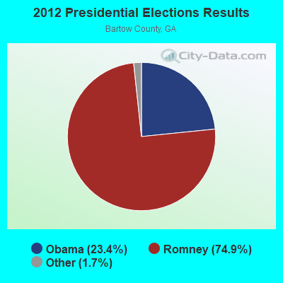
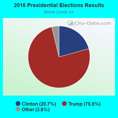
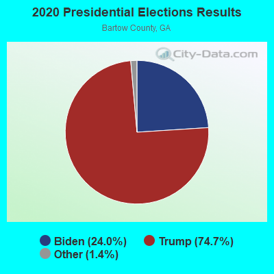
Graphs represent county-level data. Detailed 2008 Election Results
Religion statistics for Euharlee, GA (based on Bartow County data)
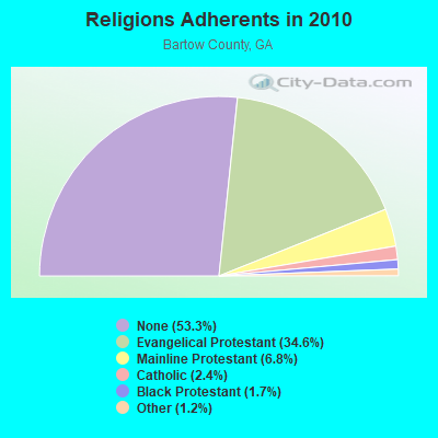
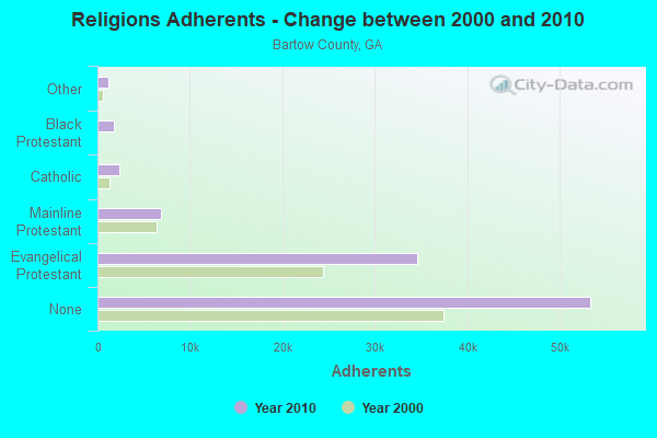
| Religion | Adherents | Congregations |
|---|---|---|
| Evangelical Protestant | 34,632 | 87 |
| Mainline Protestant | 6,830 | 19 |
| Catholic | 2,401 | 1 |
| Black Protestant | 1,727 | 8 |
| Other | 1,189 | 6 |
| None | 53,378 | - |
Food Environment Statistics:
| Bartow County: | 1.73 / 10,000 pop. |
| State: | 1.91 / 10,000 pop. |
| Bartow County: | 0.11 / 10,000 pop. |
| Georgia: | 0.15 / 10,000 pop. |
| Bartow County: | 0.22 / 10,000 pop. |
| Georgia: | 0.86 / 10,000 pop. |
| This county: | 7.24 / 10,000 pop. |
| Georgia: | 5.12 / 10,000 pop. |
| This county: | 7.67 / 10,000 pop. |
| Georgia: | 7.41 / 10,000 pop. |
| Bartow County: | 9.5% |
| State: | 10.4% |
| This county: | 26.9% |
| State: | 27.8% |
| Bartow County: | 15.0% |
| Georgia: | 14.6% |
Health and Nutrition:
| Here: | 51.6% |
| State: | 48.9% |
| This city: | 49.4% |
| State: | 46.5% |
| This city: | 27.1 |
| State: | 28.9 |
| Euharlee: | 18.3% |
| Georgia: | 20.4% |
| This city: | 8.3% |
| Georgia: | 10.8% |
| Euharlee: | 6.9 |
| Georgia: | 6.7 |
| This city: | 26.3% |
| Georgia: | 33.5% |
| This city: | 61.2% |
| Georgia: | 56.2% |
| Euharlee: | 83.2% |
| State: | 80.8% |
More about Health and Nutrition of Euharlee, GA Residents
| Local government employment and payroll (March 2022) | |||||
| Function | Full-time employees | Monthly full-time payroll | Average yearly full-time wage | Part-time employees | Monthly part-time payroll |
|---|---|---|---|---|---|
| Police Protection - Officers | 9 | $35,081 | $46,775 | 1 | $1,813 |
| Other Government Administration | 5 | $9,897 | $23,753 | 5 | $609 |
| Other and Unallocable | 3 | $9,263 | $37,052 | 0 | $0 |
| Parks and Recreation | 3 | $8,896 | $35,584 | 0 | $0 |
| Police - Other | 1 | $3,582 | $42,984 | 1 | $1,510 |
| Judicial and Legal | 0 | $0 | 1 | $2,016 | |
| Totals for Government | 21 | $66,719 | $38,125 | 8 | $5,949 |
Euharlee government finances - Expenditure in 2017 (per resident):
- Construction - Police Protection: $56,000 ($13.11)
Regular Highways: $10,000 ($2.34)
Parks and Recreation: $10,000 ($2.34)
Financial Administration: $8,000 ($1.87)
- Current Operations - Police Protection: $660,000 ($154.46)
Financial Administration: $359,000 ($84.02)
Parks and Recreation: $308,000 ($72.08)
Regular Highways: $174,000 ($40.72)
Central Staff Services: $103,000 ($24.10)
Judicial and Legal Services: $71,000 ($16.62)
General - Other: $6,000 ($1.40)
- General - Interest on Debt: $122,000 ($28.55)
- Intergovernmental to Local - Other - Libraries: $70,000 ($16.38)
Other - Health - Other: $24,000 ($5.62)
Euharlee government finances - Revenue in 2017 (per resident):
- Charges - Parks and Recreation: $94,000 ($22.00)
Other: $13,000 ($3.04)
- Local Intergovernmental - General Local Government Support: $769,000 ($179.97)
Other: $564,000 ($131.99)
- Miscellaneous - Rents: $15,000 ($3.51)
General Revenue - Other: $14,000 ($3.28)
Interest Earnings: $6,000 ($1.40)
- Tax - Insurance Premiums Sales: $258,000 ($60.38)
Public Utilities Sales: $164,000 ($38.38)
Property: $64,000 ($14.98)
Other: $57,000 ($13.34)
Alcoholic Beverage Sales: $16,000 ($3.74)
Occupation and Business License - Other: $10,000 ($2.34)
Other License: $8,000 ($1.87)
Alcoholic Beverage License: $2,000 ($0.47)
Euharlee government finances - Debt in 2017 (per resident):
- Long Term Debt - Beginning Outstanding - Unspecified Public Purpose: $3,037,000 ($710.74)
Outstanding Unspecified Public Purpose: $2,448,000 ($572.90)
Retired Unspecified Public Purpose: $588,000 ($137.61)
Euharlee government finances - Cash and Securities in 2017 (per resident):
- Bond Funds - Cash and Securities: $1,228,000 ($287.39)
- Other Funds - Cash and Securities: $661,000 ($154.69)
- Sinking Funds - Cash and Securities: $72,000 ($16.85)
Strongest AM radio stations in Euharlee:
- WFTD (1080 AM; daytime; 50 kW; MARIETTA, GA; Owner: PRIETO ENTERPRISES, INC.)
- WMLB (1160 AM; 50 kW; EAST POINT, GA; Owner: ATLANTA AREA BROADCASTING, INC.)
- WGST (640 AM; 50 kW; ATLANTA, GA; Owner: CITICASTERS LICENSES, L.P.)
- WCNN (680 AM; 50 kW; NORTH ATLANTA, GA; Owner: DICKEY BROADCASTING COMPANY)
- WKNG (1060 AM; daytime; 50 kW; TALLAPOOSA, GA; Owner: WKNG, INC.)
- WAZX (1550 AM; 50 kW; SMYRNA, GA; Owner: GA-MEX BROADCASTING, INC.)
- WSB (750 AM; 50 kW; ATLANTA, GA; Owner: CXR HOLDINGS, INC.)
- WAOK (1380 AM; 50 kW; ATLANTA, GA; Owner: INFINITY BROADCASTING OPERATIONS, INC.)
- WNSI (810 AM; 50 kW; JACKSONVILLE, AL; Owner: UNITED BROADCASTING NETWORK, INC.)
- WGUN (1010 AM; 50 kW; ATLANTA, GA; Owner: WGUN, INC.)
- WQXI (790 AM; 28 kW; ATLANTA, GA; Owner: JEFFERSON-PILOT COMMUNICATIONS COMPANY OF GEORGIA)
- WYXC (1270 AM; 2 kW; CARTERSVILLE, GA; Owner: ROGERS COMMUNICATIONS, INC.)
- WAOS (1600 AM; 20 kW; AUSTELL, GA; Owner: LA FAVORITA, INC.)
Strongest FM radio stations in Euharlee:
- WCCV (91.7 FM; CARTERSVILLE, GA; Owner: IMMANUEL BROADCASTING NETWORK, INC.)
- WTSH-FM (107.1 FM; ROCKMART, GA; Owner: BROADCAST INVESTMENT ASSOCIATES, INC)
- W214AS (90.7 FM; WALESKA, GA; Owner: CALVARY CHAPEL OF TWIN FALLS, INC.)
- W221AW (92.1 FM; NORTH CANTON, GA; Owner: IMMANUEL BROADCASTING NETWORK, INC.)
- WJCK (88.3 FM; PIEDMONT, AL; Owner: IMMANUEL BROADCASTING NETWORK, INC.)
- W215BA (90.9 FM; ROME, GA; Owner: PENSACOLA CHRISTIAN COLLEGE, INC.)
- WKCX (97.7 FM; ROME, GA; Owner: BRIAR CREEK BROADCASTING CORP.)
- WQTU (102.3 FM; ROME, GA; Owner: MCDOUGALD BROADCASTING CORPORATION)
- W212AR (90.3 FM; LINDALE, GA; Owner: WAY-FM MEDIA GROUP, INC.)
- W234AG (94.7 FM; CHATSWORTH, GA; Owner: IMMANUEL BROADCASTING NETWORK, INC.)
- WLCL (105.7 FM; CANTON, GA; Owner: CHEROKEE BROADCASTING CO., INC.)
- W265BD (100.9 FM; WOODSTOCK, GA; Owner: IMMANUEL BROADCASTING NETWORK, INC.)
- WWWQ (100.5 FM; ANNISTON, AL; Owner: WNNX LICO, INC.)
- WNNX (99.7 FM; ATLANTA, GA; Owner: WNNX LICO, INC.)
- WKHX-FM (101.5 FM; MARIETTA, GA; Owner: ABC, INC.)
- WATG (95.7 FM; TRION, GA; Owner: TTA BROADCASTING, INC)
- WRHY (105.9 FM; CENTRE, AL; Owner: WILLIAMS COMMUNICATIONS, INC.)
- WRFG (89.3 FM; ATLANTA, GA; Owner: RADIO FREE GEORGIA BROADCASTING FOUNDATION INC)
- WKLS (96.1 FM; ATLANTA, GA; Owner: CITICASTERS LICENSES, L.P.)
- WLTM (94.9 FM; ATLANTA, GA; Owner: CITICASTERS LICENSES, L.P.)
TV broadcast stations around Euharlee:
- WPXA (Channel 14; ROME, GA; Owner: PAXSON ATLANTA LICENSE, INC.)
- WUVG (Channel 34; ATHENS, GA; Owner: UNIVISION ATLANTA LLC)
- WSKC-LP (Channel 59; ATLANTA, GA; Owner: KM LPTV OF ATLANTA, L.L.C.)
- WAGA (Channel 5; ATLANTA, GA; Owner: FOX TELEVISION STATIONS, INC.)
- WSB-TV (Channel 2; ATLANTA, GA; Owner: WSB-TV HOLDINGS, INC.)
- WXIA-TV (Channel 11; ATLANTA, GA; Owner: GANNETT GEORGIA, L.P.)
- WATL (Channel 36; ATLANTA, GA; Owner: WATL, LLC)
- WTBS (Channel 17; ATLANTA, GA; Owner: SUPERSTATION, INC.)
- WGCL-TV (Channel 46; ATLANTA, GA; Owner: MEREDITH CORPORATION)
- WHSG (Channel 63; MONROE, GA; Owner: TRINITY BROADCASTING NETWORK)
- WANN-LP (Channel 32; ATLANTA, GA; Owner: PRISM BROADCASTING NETWORK, INC.)
- WDTA-LP (Channel 53; FAYETTEVILLE, GA; Owner: WORD OF GOD FELLOWSHIP, INC.)
- WUPA (Channel 69; ATLANTA, GA; Owner: VIACOM STATIONS GROUP OF ATLANTA INC.)
- WPBA (Channel 30; ATLANTA, GA; Owner: BOARD OF EDUCATION OF THE CITY OF ATLANTA)
- WTHC-LP (Channel 42; ATLANTA, GA; Owner: THE ATLANTA CHANNEL, INC.)
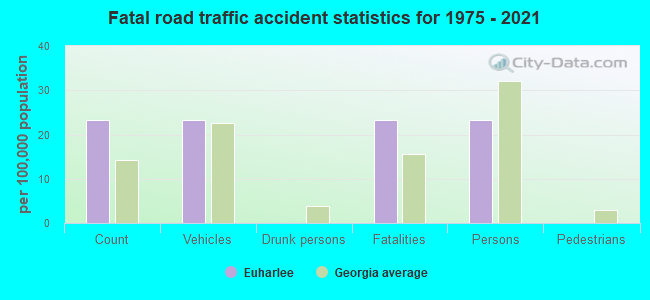
Euharlee fatal accident list:
- National Bridge Inventory (NBI) Statistics
- 16Number of bridges
- 348ft / 106mTotal length
- $20,356,000Total costs
- 79,476Total average daily traffic
- 4,970Total average daily truck traffic
- 131,314Total future (year 2029) average daily traffic
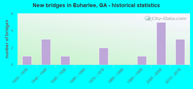
- New bridges - historical statistics
- 11930-1939
- 31940-1949
- 11950-1959
- 21970-1979
- 11990-1999
- 52000-2009
- 32010-2019
FCC Registered Antenna Towers:
16 (See the full list of FCC Registered Antenna Towers in Euharlee)FCC Registered Private Land Mobile Towers:
2- 190 Tower Dr Sw (Lat: 34.152583 Lon: -84.887444), Type: Tower, Structure height: 91 m, Call Sign: WPKN611,
Assigned Frequencies: 859.287 MHz, 859.312 MHz, 859.337 MHz, 859.362 MHz, 860.287 MHz, 860.312 MHz, 860.337 MHz, 860.362 MHz, 860.787 MHz, 860.812 MHz, Grant Date: 07/30/2019, Expiration Date: 06/08/2029, Registrant: Southern Communications Services, Inc D/B/A Southern Linc, 600 18th St N Bin Sn-0800, Birmingham, AL 35203-2206, Phone: (205) 257-1534, Email:
- 190 Tower Dr Sw (Lat: 34.152583 Lon: -84.887444), Type: Tower, Structure height: 91 m, Call Sign: WQJM880,
Assigned Frequencies: 857.337 MHz, Grant Date: 04/28/2009, Expiration Date: 06/08/2019, Cancellation Date: 06/28/2012, Certifier: Robin J Cohen, Registrant: Sprint Nextel Corporation, 12502 Sunrise Valley Drive, M/S: Varesa0209, Reston, VA 20196, Phone: (703) 433-4000, Fax: (703) 433-4483
FCC Registered Broadcast Land Mobile Towers:
1- Burge\'s Mill Road (Lat: 34.144500 Lon: -84.758778), Call Sign: WPWC861,
Assigned Frequencies: 159.142 MHz, 159.142 MHz, Grant Date: 08/02/2022, Expiration Date: 10/16/2032, Certifier: Billy Worthington, Registrant: South Comm, 3 Central Plaza, S-207, Rome, GA 30161, Phone: (770) 386-6456, Fax: (440) 458-5511, Email:
FCC Registered Microwave Towers:
5- AT72XC057, 190 Tower Drive (Lat: 34.152444 Lon: -84.887611), Type: Gtower, Structure height: 91.7 m, Overall height: 97.5 m, Call Sign: WQQZ268,
Assigned Frequencies: 11345.0 MHz, 11345.0 MHz, 11345.0 MHz, 11345.0 MHz, 11345.0 MHz, 11345.0 MHz, Grant Date: 03/28/2013, Expiration Date: 03/28/2023, Cancellation Date: 04/01/2022, Certifier: Kyle B Entz, Registrant: T-Mobile Usa, Inc., 12920 Se 38th Street, Bellevue, WA 98006, Phone: (425) 383-8401, Fax: (425) 383-4840, Email:
- EUHARLEE, 190 Tower Drive (Lat: 34.152444 Lon: -84.887611), Type: Gtower, Structure height: 91.7 m, Overall height: 97.5 m, Call Sign: WQWQ382,
Assigned Frequencies: 11225.0 MHz, 11305.0 MHz, Grant Date: 10/26/2015, Expiration Date: 10/26/2025, Certifier: Gregory M Romano, Registrant: Verizon, 1300 I St Nw - Suite 500 East, Washington, DC 20005, Phone: (202) 515-2453, Email:
- HODGEMTN, 190 Tower Drive (Lat: 34.152444 Lon: -84.887611), Type: Gtower, Structure height: 91.7 m, Overall height: 97.5 m, Call Sign: WQYP616,
Assigned Frequencies: 11545.0 MHz, 11585.0 MHz, 11545.0 MHz, 11585.0 MHz, 11545.0 MHz, 11585.0 MHz, 11545.0 MHz, 11585.0 MHz, 11545.0 MHz, 11585.0 MHz... (+22 more), Grant Date: 12/01/2016, Expiration Date: 12/01/2026, Certifier: Larry F Butts, Registrant: Southern Company Services, 600 N. 18th St / Bin 5n-5409, Birmingham, AL 35203, Phone: (205) 257-7600, Fax: (205) 257-2134, Email:
- EUHARLEE FS3, 1212 Euharlee Road (Lat: 34.152667 Lon: -84.937028), Type: Ltower, Structure height: 103.6 m, Overall height: 109.7 m, Call Sign: WRCS422, Licensee ID: L00013092,
Assigned Frequencies: 5945.20 MHz, 6093.45 MHz, 6063.80 MHz, Grant Date: 12/20/2018, Expiration Date: 12/20/2028, Certifier: William Little, Registrant: County Of Bartow, 104 Zena Drive, Cartersville, GA 30120, Phone: (770) 382-5050
- BARTOW-FS3, 1212 Euharlee Road (Lat: 34.152694 Lon: -84.936889), Type: Ltower, Structure height: 103.6 m, Overall height: 109.7 m, Call Sign: WRMY799, Licensee ID: L00160047,
Assigned Frequencies: 11485.0 MHz, Grant Date: 06/25/2021, Expiration Date: 06/25/2031, Certifier: Crystal P Vincent, Registrant: Polk County, 53 Cline Ingram Jackson Rd, Cedartown, GA 30125, Phone: (770) 749-2191, Email:
FCC Registered Amateur Radio Licenses:
6- Call Sign: KC4WFV, Licensee ID: L00174491, Grant Date: 12/07/2021, Expiration Date: 02/18/2032, Certifier: Robert D La Fore, Registrant: Robert D La Fore, 27 Moss Ln, Euharlee, GA 30145
- Call Sign: KG4GYK, Licensee ID: L00222914, Grant Date: 02/08/2020, Expiration Date: 03/29/2030, Certifier: Dennis D Knight, Registrant: Dennis D Knight, 378 Euharlee Rd Sw, Euharlee, GA 30120
- Call Sign: KK4SEH, Licensee ID: L01797548, Grant Date: 03/21/2024, Expiration Date: 03/21/2034, Certifier: William D Mitchum, Registrant: William D Mitchum, 131 Amberwood Ln, Euharlee, GA 30145
- Call Sign: KM4ANN, Licensee ID: L01859975, Grant Date: 04/23/2014, Expiration Date: 04/23/2024, Certifier: Nathan T Floyd, Registrant: Nathan T Floyd, 33 Lowry Way, Euharlee, GA 30145
- Call Sign: KN4QXN, Licensee ID: L02228368, Grant Date: 11/27/2018, Expiration Date: 11/27/2028, Certifier: Benjamin G Tomlinson, Registrant: Benjamin G Tomlinson, 22 Misty Ridge Dr, Euharlee, GA 30145
- Call Sign: KN4VWT, Licensee ID: L02280526, Grant Date: 07/23/2019, Expiration Date: 07/23/2029, Cancellation Date: 08/20/2019, Certifier: Alan W Brue, Registrant: Alan W Brue, 21 Devin Ln, Euharlee, GA 30145
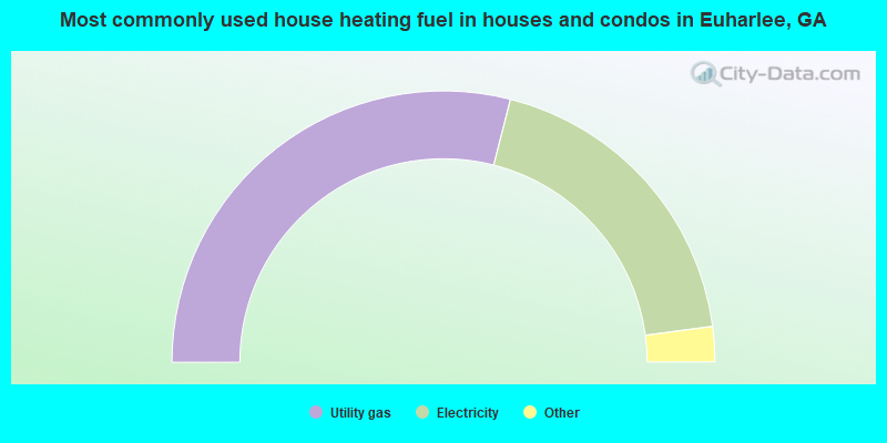
- 58.0%Utility gas
- 37.9%Electricity
- 1.7%Fuel oil, kerosene, etc.
- 1.4%Bottled, tank, or LP gas
- 1.0%Wood
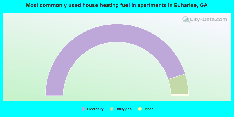
- 90.6%Electricity
- 9.4%Utility gas
Euharlee compared to Georgia state average:
- Unemployed percentage below state average.
- Hispanic race population percentage below state average.
- Median age below state average.
- Foreign-born population percentage significantly below state average.
- Renting percentage below state average.
- House age below state average.

|
Total of 2 patent applications in 2008-2024.