Granby, Vermont
Submit your own pictures of this town and show them to the world
- OSM Map
- General Map
- Google Map
- MSN Map

Population change since 2000: +2.3%
 |
| Males: 43 | |
| Females: 45 |
| Median resident age: | 51.3 years |
| Vermont median age: | 45.8 years |
Zip code: 05840
| Granby: | $71,324 |
| VT: | $73,991 |
Estimated per capita income in 2022: $68,177 (it was $30,343 in 2000)
Estimated median house or condo value in 2022: $183,482 (it was $76,700 in 2000)
| Granby: | $183,482 |
| VT: | $304,700 |


- 8495.5%White alone
- 33.4%Two or more races
- 11.1%Black alone

 Recent articles from our blog. Our writers, many of them Ph.D. graduates or candidates, create easy-to-read articles on a wide variety of topics.


 | Brattleboro, VT (28 replies) |
| News, VT anti-smoking law among nation's strictest (122 replies) |
| disincorporation of Town of Victory proposed (5 replies) |
| Girlfriend and I considering moving up north, could Burlington be the right place for us? (10 replies) |
| Trader Joe's, Whole Foods, French Bakeries and IKEA (43 replies) |
| The Drive from Mass (26 replies) |
Latest news from Granby, VT collected exclusively by city-data.com from local newspapers, TV, and radio stations
Ancestries: English (14.0%), French (7.0%), Irish (5.8%), Scottish (5.8%), Dutch (3.5%), French Canadian (3.5%).
Current Local Time: EST time zone
Elevation: 1456 feet
Land area: 39.0 square miles.
Population density: 2.3 people per square mile (very low).

3 residents are foreign born (3.5% North America).
| This town: | 3.5% |
| Vermont: | 3.8% |
| Granby town: | 1.2% ($933) |
| Vermont: | 2.0% ($2,196) |
Nearest city with pop. 50,000+: Portland, ME  (97.2 miles , pop. 64,249).
Nearest city with pop. 200,000+: Boston, MA (161.5 miles , pop. 589,141).
Nearest city with pop. 1,000,000+: Bronx, NY (282.6 miles , pop. 1,332,650).
Nearest cities:
), ), ), )Latitude: 44.61 N, Longitude: 71.72 W
Area code commonly used in this area: 802


Single-family new house construction building permits:
- 2021: 1 building, cost: $100,000
- 2020: 1 building, cost: $100,000
- 1998: 1 building, cost: $12,000
- 1997: 1 building, cost: $12,000


| Here: | 2.9% |
| Vermont: | 2.0% |

Average climate in Granby, Vermont
Based on data reported by over 4,000 weather stations


(lower is better)

Air Quality Index (AQI) level in 2002 was 4.67. This is significantly better than average.
| City: | 4.67 |
| U.S.: | 72.56 |

Sulfur Dioxide (SO2) [ppb] level in 2002 was 1.47. This is about average. Closest monitor was 9.9 miles away from the city center.
| City: | 1.47 |
| U.S.: | 1.51 |
Earthquake activity:
Granby-area historical earthquake activity is significantly above Vermont state average. It is 74% smaller than the overall U.S. average.On 4/20/2002 at 10:50:47, a magnitude 5.3 (5.3 ML, Depth: 3.0 mi, Class: Moderate, Intensity: VI - VII) earthquake occurred 97.9 miles away from the city center
On 4/20/2002 at 10:50:47, a magnitude 5.2 (5.2 MB, 4.2 MS, 5.2 MW, 5.0 MW) earthquake occurred 99.1 miles away from the city center
On 10/7/1983 at 10:18:46, a magnitude 5.3 (5.1 MB, 5.3 LG, 5.1 ML) earthquake occurred 137.8 miles away from the city center
On 1/19/1982 at 00:14:42, a magnitude 4.7 (4.5 MB, 4.7 MD, 4.5 LG, Class: Light, Intensity: IV - V) earthquake occurred 77.2 miles away from the city center
On 10/16/2012 at 23:12:25, a magnitude 4.7 (4.7 ML, Depth: 10.0 mi) earthquake occurred 87.7 miles away from the city center
On 6/16/1995 at 12:13:11, a magnitude 3.8 (3.8 LG, Depth: 3.1 mi, Class: Light, Intensity: II - III) earthquake occurred 24.6 miles away from Granby center
Magnitude types: regional Lg-wave magnitude (LG), body-wave magnitude (MB), duration magnitude (MD), local magnitude (ML), surface-wave magnitude (MS), moment magnitude (MW)
Natural disasters:
The number of natural disasters in Essex County (20) is greater than the US average (15).Major Disasters (Presidential) Declared: 15
Emergencies Declared: 1
Causes of natural disasters: Floods: 14, Storms: 13, Tropical Storms: 2, Winter Storms: 2, Heavy Rain: 1, Hurricane: 1, Landslide: 1, Other: 1 (Note: some incidents may be assigned to more than one category).

Hospitals and medical centers near Granby:
- NORTHWOODS HOME HEALTH AND HOSPICE (Home Health Center, about 10 miles away; LANCASTER, NH)
- COUNTRY VILLAGE CENTER, GENESIS HEALTHCARE (Nursing Home, about 11 miles away; LANCASTER, NH)
- MCKERLEY HEALTH CARE CENTER (Nursing Home, about 11 miles away; LANCASTER, NH)
- FRESENIUS MEDICAL CARE OF LANCASTER (Dialysis Facility, about 12 miles away; LANCASTER, NH)
- WEEKS MEDICAL CENTER Critical Access Hospitals (about 12 miles away; LANCASTER, NH)
- PINES REHAB AND HEALTH CTR (Nursing Home, about 16 miles away; LYNDONVILLE, VT)
Colleges/universities with over 2000 students nearest to Granby:
- Norwich University (about 58 miles; Northfield, VT; Full-time enrollment: 4,221)
- Plymouth State University (about 60 miles; Plymouth, NH; FT enrollment: 4,838)
- Dartmouth College (about 70 miles; Hanover, NH; FT enrollment: 6,030)
- Saint Michael's College (about 72 miles; Colchester, VT; FT enrollment: 2,336)
- Community College of Vermont (about 73 miles; Winooski, VT; FT enrollment: 3,394)
- University of Vermont (about 74 miles; Burlington, VT; FT enrollment: 11,566)
- Champlain College (about 75 miles; Burlington, VT; FT enrollment: 2,623)
Points of interest:
Cemeteries: Rogers Rangers Cemetery (1), Granby Village Cemetery (2), Boyce Cemetery (3), North Victory Cemetery (4), Porrell Cemetery (5). Display/hide their locations on the map
Lakes and swamps: Cow Mountain Pond (A), Mud Pond (B), Little Mud Pond (C), Granby Bog (D). Display/hide their locations on the map
Streams, rivers, and creeks: Stony Brook (A), Sable Mountain Brook (B), Pond Brook (C), Lund Brook (D), Tolman Brook (E), Jones Brook (F), Wilke Brook (G), Applelon Brook (H), Fitch Brook (I). Display/hide their locations on the map
| This town: | 2.0 people |
| Vermont: | 2.3 people |
| This town: | 65.1% |
| Whole state: | 62.5% |
| This town: | 2.3% |
| Whole state: | 9.2% |
No gay or lesbian households reported
For population 15 years and over in Granby:

- Never married: 12.3%
- Now married: 87.7%
- Separated: 0.0%
- Widowed: 0.0%
- Divorced: 0.0%
For population 25 years and over in Granby:
- High school or higher: 71.9%
- Bachelor's degree or higher: 14.0%
- Graduate or professional degree: 14.0%
- Mean travel time to work (commute): 60.5 minutes


| Here: | 13.5 |
| Vermont average: | 11.7 |
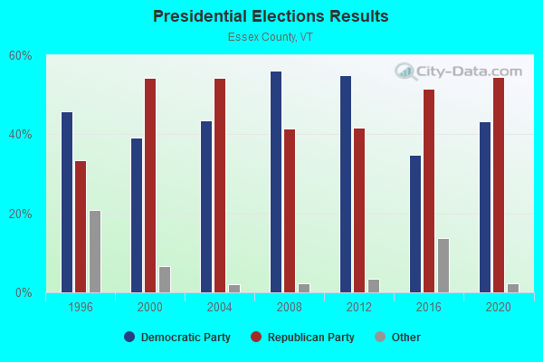
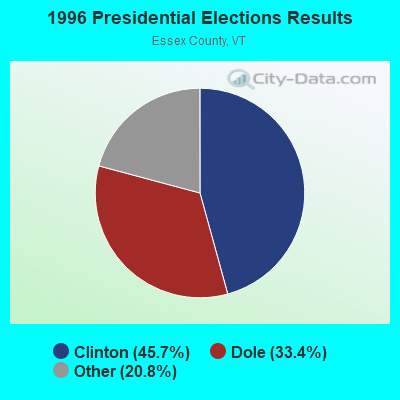
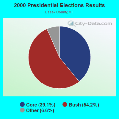
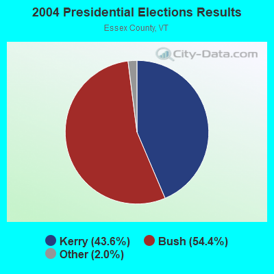
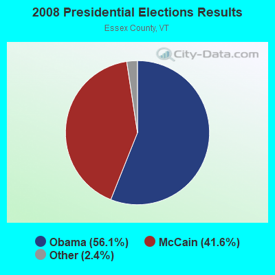

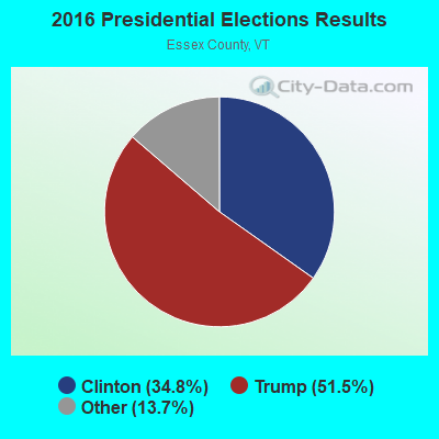
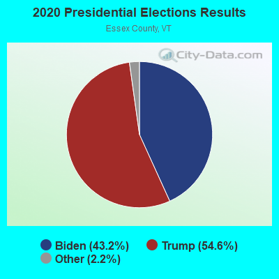
Graphs represent county-level data. Detailed 2008 Election Results
Religion statistics for Granby, VT (based on Essex County data)
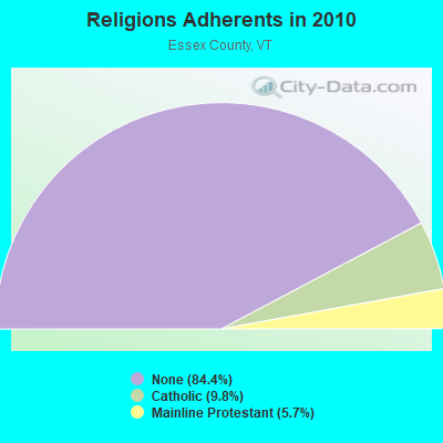
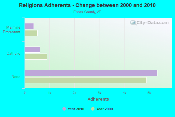
| Religion | Adherents | Congregations |
|---|---|---|
| Catholic | 619 | 2 |
| Mainline Protestant | 360 | 11 |
| Other | 3 | - |
| None | 5,324 | - |
Food Environment Statistics:
| This county: | 3.08 / 10,000 pop. |
| State: | 3.84 / 10,000 pop. |
| This county: | 6.16 / 10,000 pop. |
| Vermont: | 6.40 / 10,000 pop. |
| Here: | 15.40 / 10,000 pop. |
| Vermont: | 11.52 / 10,000 pop. |
| This county: | 6.7% |
| Vermont: | 6.8% |
| Essex County: | 25.1% |
| Vermont: | 22.3% |
| Essex County: | 11.3% |
| Vermont: | 13.3% |
Strongest AM radio stations in Granby:
- WCHP (760 AM; 35 kW; CHAMPLAIN, NY; Owner: CHAMPLAIN RADIO, INC.)
- WTME (780 AM; 10 kW; RUMFORD, ME; Owner: MOUNTAIN VALLEY BROADCASTING, INC.)
- WTWN (1100 AM; daytime; 5 kW; WELLS RIVER, VT; Owner: PUFFER BROADCASTING, INC.)
- WRKO (680 AM; 50 kW; BOSTON, MA; Owner: ENTERCOM BOSTON LICENSE, LLC)
- WDEV (550 AM; 5 kW; WATERBURY, VT; Owner: RADIO VERMONT, INC.)
- WNNZ (640 AM; 50 kW; WESTFIELD, MA; Owner: CLEAR CHANNEL BROADCASTING LICENSES, INC.)
- WICY (1490 AM; 50 kW; MALONE, NY; Owner: CARTIER COMMUNICATIONS INC.)
- WCRN (830 AM; 50 kW; WORCESTER, MA; Owner: CARTER BROADCASTING CORPORATION)
- WEEI (850 AM; 50 kW; BOSTON, MA; Owner: ENTERCOM BOSTON LICENSE, LLC)
- WGY (810 AM; 50 kW; SCHENECTADY, NY; Owner: CLEAR CHANNEL BROADCASTING LICENSES, INC.)
- WSTJ (1340 AM; 1 kW; ST. JOHNSBURY, VT; Owner: VERMONT BROADCAST ASSOCIATES, INC.)
- WBZ (1030 AM; 50 kW; BOSTON, MA; Owner: INFINITY BROADCASTING OPERATIONS, INC.)
- WLTN (1400 AM; 1 kW; LITTLETON, NH; Owner: PROFILE BROADCASTING COMPANY, INC.)
Strongest FM radio stations in Granby:
- WGMT (97.7 FM; LYNDON, VT; Owner: VERMONT BROADCAST ASSOCIATES, INC.)
- WPKQ (103.7 FM; NORTH CONWAY, NH; Owner: CITADEL BROADCASTING COMPANY)
- WHOM (94.9 FM; MT. WASHINGTON, NH; Owner: CITADEL BROADCASTING COMPANY)
- WMTK (106.3 FM; LITTLETON, NH; Owner: VERMONT BROADCAST ASSOCIATES, INC.)
- WXXS (102.3 FM; LANCASTER, NH; Owner: BARRY P. LUNDERVILLE)
- WCKJ (90.5 FM; ST. JOHNSBURY, VT; Owner: CHRISTIAN MINISTRIES, INC.)
- WKXH (105.5 FM; ST. JOHNSBURY, VT; Owner: VERMONT BROADCAST ASSOCIATES, INC.)
- WLKC (103.3 FM; WATERBURY, VT; Owner: RADIO BROADCASTING SERVICES, INC.)
- WVPS (107.9 FM; BURLINGTON, VT; Owner: VERMONT PUBLIC RADIO)
- WEZF (92.9 FM; BURLINGTON, VT; Owner: CAPSTAR TX LIMITED PARTNERSHIP)
- WDOT (95.7 FM; DANVILLE, VT; Owner: MONTPELIER BROADCASTING INC)
- WCVT (101.7 FM; STOWE, VT; Owner: RADIO VERMONT CLASSICS, L.L.C.)
- WVFM (105.7 FM; CAMPTON, NH; Owner: DEVON BROADCASTING COMPANY, INC.)
- WNCS (104.7 FM; MONTPELIER, VT; Owner: MONTPELIER BROADCASTING, INC.)
- WSCY (106.9 FM; MOULTONBOROUGH, NH; Owner: NORTHEAST COMMUNICATIONS CORPORATION)
- W243AE (96.5 FM; ORLEANS, VT; Owner: CHRISTIAN MINISTRIES, INC.)
- WLOB-FM (96.3 FM; RUMFORD, ME; Owner: ATLANTIC COAST RADIO, LLC)
- WLTN-FM (96.7 FM; LISBON, NH; Owner: PROFILE BROADCASTING CO., INC.)
- WMOO (92.1 FM; DERBY CENTER, VT; Owner: NORTHSTAR MEDIA, INC.)
TV broadcast stations around Granby:
- WLED-TV (Channel 49; LITTLETON, NH; Owner: UNIVERSITY OF NEW HAMPSHIRE)
- WVTB (Channel 20; ST. JOHNSBURY, VT; Owner: VERMONT ETV, INC.)
- W36CP (Channel 36; NEWPORT, VT; Owner: NYN, LLC)
- National Bridge Inventory (NBI) Statistics
- 1Number of bridges
- 3ft / 0.9mTotal length
- 100Total average daily traffic
- 2Total average daily truck traffic
- 105Total future (year 2026) average daily traffic
Granby compared to Vermont state average:
- Median house value below state average.
- Unemployed percentage significantly below state average.
- Hispanic race population percentage significantly below state average.
- Median age above state average.
- Renting percentage below state average.
- Length of stay since moving in significantly above state average.
- Number of rooms per house significantly below state average.
- House age significantly below state average.
- Number of college students below state average.
- Percentage of population with a bachelor's degree or higher significantly below state average.