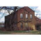
Irondale, Missouri
Submit your own pictures of this city and show them to the world
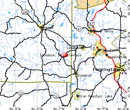
- OSM Map
- General Map
- Google Map
- MSN Map
Population change since 2000: -16.0%
 |
| Males: 218 | |
| Females: 149 |
| Median resident age: | 35.4 years |
| Missouri median age: | 39.1 years |
Zip codes: 63648.
| Irondale: | $24,073 |
| MO: | $64,811 |
Estimated per capita income in 2022: $14,787 (it was $11,819 in 2000)
Irondale city income, earnings, and wages data
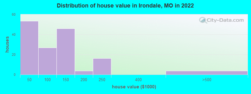
Estimated median house or condo value in 2022: $106,828 (it was $30,000 in 2000)
| Irondale: | $106,828 |
| MO: | $221,200 |
Mean prices in 2022: all housing units: $90,549; detached houses: $99,834; mobile homes: $50,087
Median gross rent in 2022: $996.
(47.3% for White Non-Hispanic residents, 27.1% for two or more races residents)
Detailed information about poverty and poor residents in Irondale, MO
Compare current foreclosures near Irondale, MO:
| Photo | Address | Area | Beds / Baths | Price | Details |
|---|---|---|---|---|---|

|
#1
Cherokee, # 48
Irondale, MO 63648
|
- sq. feet
|
- baths - beds |
show details | |

|
#2
Dubay Dr
Cadet, MO 63630
|
2,292 sq. feet
|
2 baths 4 beds |
$435,000
|
show details |

|
#3
Highway N
Middle Brook, MO 63656
|
1,560 sq. feet
|
2 baths 3 beds |
$144,900
|
show details |

|
#4
E State Hwy E
Cadet, MO 63630
|
2,008 sq. feet
|
2 baths 5 beds |
$79,900
|
show details |

|
#5
State Highway U
Irondale, MO 63648
|
- sq. feet
|
- baths - beds |
show details | |

|
#6
Mossey Oak Ln
Irondale, MO 63648
|
- sq. feet
|
- baths - beds |
show details | |

|
#7
Iroquois
Irondale, MO 63648
|
- sq. feet
|
- baths - beds |
show details | |

|
#8
Lake Dr
Bonne Terre, MO 63628
|
960 sq. feet
|
1 baths 4 beds |
show details | |

|
#9
Smith St
Farmington, MO 63640
|
1,104 sq. feet
|
2 baths 3 beds |
show details | |

|
#10
Taylor Ave
Park Hills, MO 63601
|
1,308 sq. feet
|
1 baths 2 beds |
show details |
| Photo | Address | Area | Beds / Baths | Price | Details |
|---|---|---|---|---|---|

|
#11
Twin St
Bonne Terre, MO 63628
|
1,188 sq. feet
|
1 baths 3 beds |
show details | |

|
#12
E Elm St
Park Hills, MO 63601
|
- sq. feet
|
1 baths 2 beds |
show details | |

|
#13
Oakleaf Rd
Cadet, MO 63630
|
- sq. feet
|
1 baths 2 beds |
show details | |

|
#14
N Grant St
Park Hills, MO 63601
|
- sq. feet
|
1 baths 3 beds |
show details | |

|
#15
Short St
Bonne Terre, MO 63628
|
- sq. feet
|
1 baths 2 beds |
show details | |

|
#16
Houser St
Park Hills, MO 63601
|
- sq. feet
|
2 baths 4 beds |
show details | |

|
#17
Berry Rd
Bonne Terre, MO 63628
|
- sq. feet
|
1 baths 2 beds |
show details | |

|
#18
Parkway Dr
Bismarck, MO 63624
|
- sq. feet
|
1 baths 2 beds |
show details | |

|
#19
Lakewood Dr
De Soto, MO 63020
|
1,440 sq. feet
|
2 baths - beds |
show details | |

|
#20
1st St
Bonne Terre, MO 63628
|
- sq. feet
|
- baths - beds |
show details |
| Photo | Address | Area | Beds / Baths | Price | Details |
|---|---|---|---|---|---|

|
#21
Aldergate Dr Apt 17
Bonne Terre, MO 63628
|
- sq. feet
|
- baths - beds |
show details | |

|
#22
Reese St
Bonne Terre, MO 63628
|
- sq. feet
|
- baths - beds |
show details | |

|
#23
Glendale St
Potosi, MO 63664
|
- sq. feet
|
- baths - beds |
show details | |

|
#24
Brooksana Ave
Park Hills, MO 63601
|
- sq. feet
|
- baths - beds |
show details | |

|
#25
Yale St
Bonne Terre, MO 63628
|
- sq. feet
|
- baths - beds |
show details | |

|
#26
N Saint Joe Dr Apt 3
Park Hills, MO 63601
|
- sq. feet
|
- baths - beds |
show details | |

|
#27
Falcon St Apt 62
Park Hills, MO 63601
|
- sq. feet
|
- baths - beds |
show details | |

|
#28
Dale St Apt B
Bonne Terre, MO 63628
|
- sq. feet
|
- baths - beds |
show details | |

|
#29
E Jefferson St
Potosi, MO 63664
|
- sq. feet
|
- baths - beds |
show details | |

|
#30
Summit St
Bonne Terre, MO 63628
|
- sq. feet
|
- baths - beds |
show details |
| Photo | Address | Area | Beds / Baths | Price | Details |
|---|---|---|---|---|---|

|
#31
Ash St
Bonne Terre, MO 63628
|
- sq. feet
|
- baths - beds |
show details | |

|
#32
Old Prairie Rd
Cadet, MO 63630
|
- sq. feet
|
- baths - beds |
show details | |

|
#33
Victoria Ave
Park Hills, MO 63601
|
- sq. feet
|
- baths - beds |
show details | |

|
#34
Highway O
Belleview, MO 63623
|
- sq. feet
|
- baths - beds |
show details | |

|
#35
Chapel Rd
Potosi, MO 63664
|
- sq. feet
|
- baths - beds |
show details | |

|
#36
Woodhaven Rd
Cadet, MO 63630
|
- sq. feet
|
- baths - beds |
show details | |

|
#37
Juliette Rd
Cadet, MO 63630
|
- sq. feet
|
- baths - beds |
show details | |

|
#38
Turley Mill Rd
Farmington, MO 63640
|
- sq. feet
|
- baths - beds |
show details | |

|
#39
Airline Dr
Farmington, MO 63640
|
- sq. feet
|
- baths - beds |
show details | |

|
#40
Hilltop Place Dr
Farmington, MO 63640
|
- sq. feet
|
- baths - beds |
show details |
| Photo | Address | Area | Beds / Baths | Price | Details |
|---|---|---|---|---|---|

|
#41
Blackwell Heights Road
Blackwell, MO 63626
|
- sq. feet
|
- baths - beds |
show details | |

|
#42
N Washington St Apt 48
Farmington, MO 63640
|
- sq. feet
|
- baths - beds |
show details | |

|
#43
London Rd
Farmington, MO 63640
|
- sq. feet
|
- baths - beds |
show details | |

|
#44
Southlake Dr
De Soto, MO 63020
|
- sq. feet
|
2 baths - beds |
show details | |

|
#45
Haw St Apt A
Farmington, MO 63640
|
- sq. feet
|
- baths - beds |
show details | |

|
#46
Doubet Ln
Farmington, MO 63640
|
- sq. feet
|
- baths - beds |
show details | |

|
#47
Junction Rd
Cadet, MO 63630
|
- sq. feet
|
- baths - beds |
show details | |

|
#48
Doubet Ln
Farmington, MO 63640
|
- sq. feet
|
- baths - beds |
show details | |

|
#49
Blackfoot Rd
Potosi, MO 63664
|
- sq. feet
|
- baths - beds |
show details | |

|
Check over 1 million property listings on Foreclosure.com!
|
browse all offers | |||


- 49688.3%White alone
- 6110.9%Two or more races
- 112.0%Asian alone
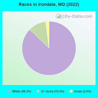
Races in Irondale detailed stats: ancestries, foreign born residents, place of birth
According to our research of Missouri and other state lists, there were 12 registered sex offenders living in Irondale, Missouri as of April 26, 2024.
The ratio of all residents to sex offenders in Irondale is 35 to 1.
 Recent articles from our blog. Our writers, many of them Ph.D. graduates or candidates, create easy-to-read articles on a wide variety of topics.


 | Missouri Outlaw History (3407 replies) |
| Interesting Missouri facts. (1186 replies) |
| relocation options from Vegas to?? (14 replies) |
Latest news from Irondale, MO collected exclusively by city-data.com from local newspapers, TV, and radio stations
Ancestries: American (37.3%), German (24.7%), French (9.3%), Irish (4.0%), Scottish (3.3%).
Current Local Time: CST time zone
Incorporated in 1910
Elevation: 810 feet
Land area: 0.54 square miles.
Population density: 675 people per square mile (low).
12 residents are foreign born (2.3% Asia).
| This city: | 2.1% |
| Missouri: | 4.2% |
Median real estate property taxes paid for housing units with mortgages in 2022: $1,204 (0.8%)
Median real estate property taxes paid for housing units with no mortgage in 2022: $330 (1.1%)
Nearest city with pop. 50,000+: St. Louis, MO  (59.6 miles , pop. 348,189).
Nearest city with pop. 1,000,000+: Chicago, IL (319.4 miles , pop. 2,896,016).
Nearest cities:
), ), ), ), )Latitude: 37.84 N, Longitude: 90.67 W
Area code: 573

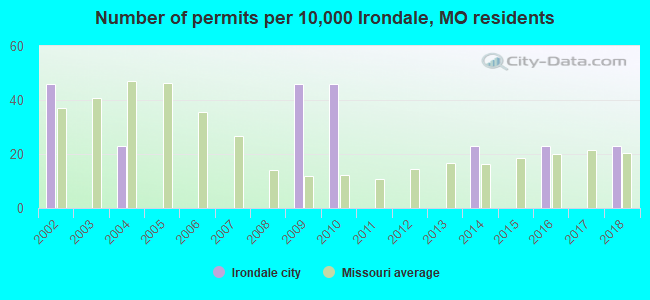
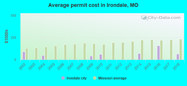
Single-family new house construction building permits:
- 2018: 1 building, cost: $65,000
- 2016: 1 building, cost: $160,000
- 2014: 1 building, cost: $70,000
- 2010: 2 buildings, average cost: $62,500
- 2009: 2 buildings, average cost: $42,500
- 2004: 1 building, cost: $50,000
- 2002: 2 buildings, average cost: $90,000
| Here: | 3.7% |
| Missouri: | 2.8% |
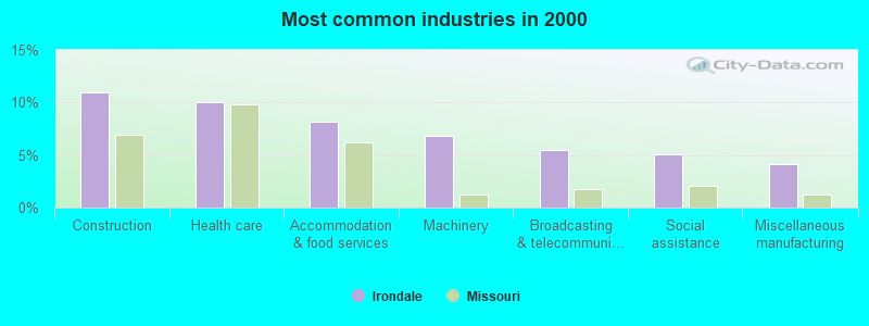
- Construction (11.0%)
- Health care (10.0%)
- Accommodation & food services (8.2%)
- Machinery (6.8%)
- Broadcasting & telecommunications (5.5%)
- Social assistance (5.0%)
- Miscellaneous manufacturing (4.1%)
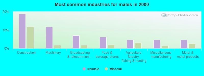
- Construction (18.8%)
- Machinery (11.7%)
- Broadcasting & telecommunications (7.0%)
- Food & beverage stores (6.2%)
- Agriculture, forestry, fishing & hunting (4.7%)
- Miscellaneous manufacturing (4.7%)
- Metal & metal products (4.7%)
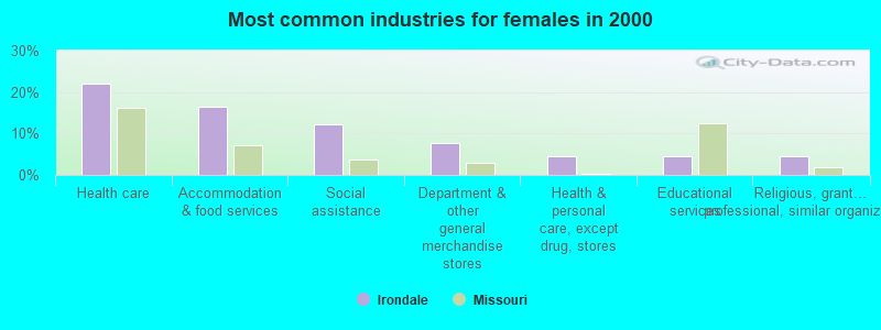
- Health care (22.0%)
- Accommodation & food services (16.5%)
- Social assistance (12.1%)
- Department & other general merchandise stores (7.7%)
- Health & personal care, except drug, stores (4.4%)
- Educational services (4.4%)
- Religious, grantmaking, civic, professional, similar organizations (4.4%)
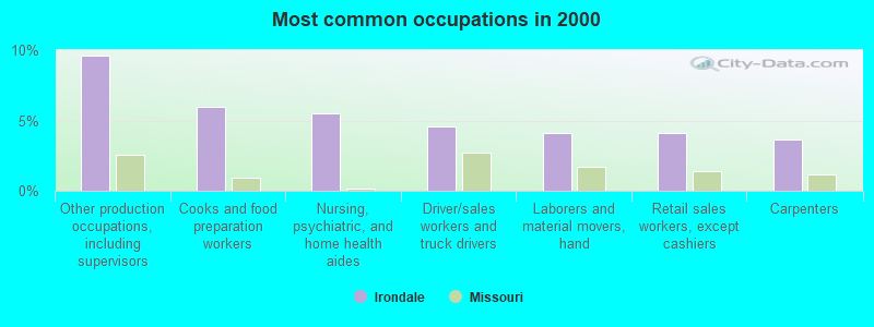
- Other production occupations, including supervisors (9.6%)
- Cooks and food preparation workers (5.9%)
- Nursing, psychiatric, and home health aides (5.5%)
- Driver/sales workers and truck drivers (4.6%)
- Laborers and material movers, hand (4.1%)
- Retail sales workers, except cashiers (4.1%)
- Carpenters (3.7%)
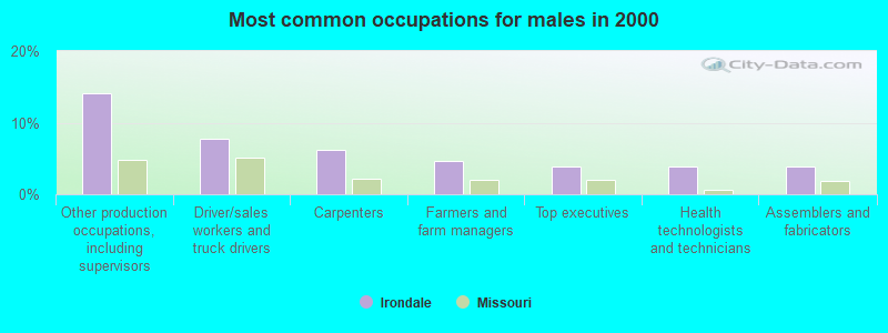
- Other production occupations, including supervisors (14.1%)
- Driver/sales workers and truck drivers (7.8%)
- Carpenters (6.2%)
- Farmers and farm managers (4.7%)
- Top executives (3.9%)
- Health technologists and technicians (3.9%)
- Assemblers and fabricators (3.9%)
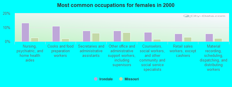
- Nursing, psychiatric, and home health aides (13.2%)
- Cooks and food preparation workers (11.0%)
- Secretaries and administrative assistants (7.7%)
- Other office and administrative support workers, including supervisors (7.7%)
- Counselors, social workers, and other community and social service specialists (6.6%)
- Retail sales workers, except cashiers (5.5%)
- Material recording, scheduling, dispatching, and distributing workers (5.5%)
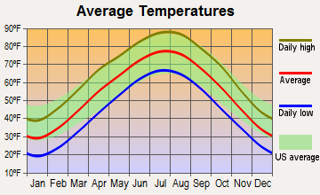
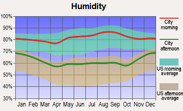
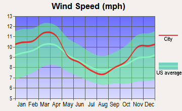
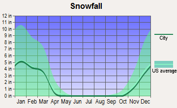
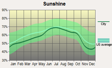
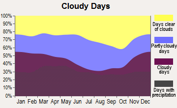
Average climate in Irondale, Missouri
Based on data reported by over 4,000 weather stations
(lower is better)
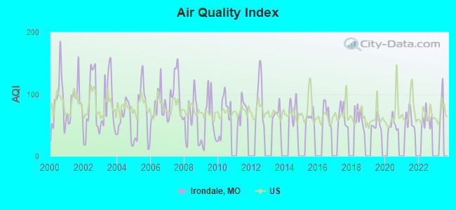
Air Quality Index (AQI) level in 2022 was 58.8. This is better than average.
| City: | 58.8 |
| U.S.: | 72.6 |
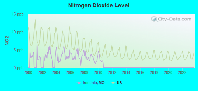
Nitrogen Dioxide (NO2) [ppb] level in 2010 was 2.53. This is significantly better than average. Closest monitor was 14.3 miles away from the city center.
| City: | 2.53 |
| U.S.: | 5.11 |
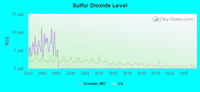
Sulfur Dioxide (SO2) [ppb] level in 2003 was 6.70. This is significantly worse than average. Closest monitor was 18.6 miles away from the city center.
| City: | 6.70 |
| U.S.: | 1.51 |
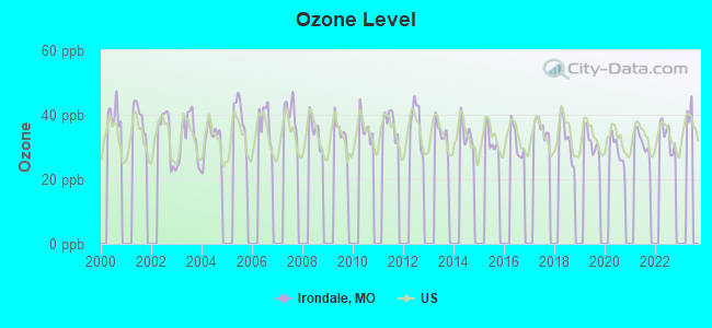
Ozone [ppb] level in 2022 was 33.4. This is about average. Closest monitor was 14.3 miles away from the city center.
| City: | 33.4 |
| U.S.: | 33.3 |
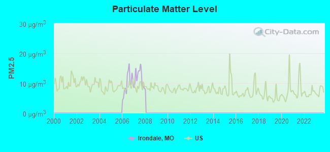
Particulate Matter (PM2.5) [µg/m3] level in 2007 was 11.7. This is significantly worse than average. There were 0 monitors within city limits.
| City: | 11.7 |
| U.S.: | 8.1 |
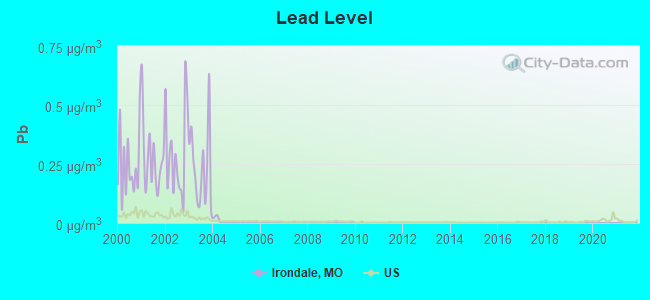
Lead (Pb) [µg/m3] level in 2003 was 0.237. This is significantly worse than average. Closest monitor was 8.7 miles away from the city center.
| City: | 0.237 |
| U.S.: | 0.009 |
Tornado activity:
Irondale-area historical tornado activity is near Missouri state average. It is 59% greater than the overall U.S. average.
On 12/21/1967, a category F4 (max. wind speeds 207-260 mph) tornado 9.0 miles away from the Irondale city center killed 3 people and injured 52 people and caused between $500,000 and $5,000,000 in damages.
On 6/22/1969, a category F4 tornado 9.9 miles away from the city center killed 4 people and injured 14 people and caused between $500,000 and $5,000,000 in damages.
Earthquake activity:
Irondale-area historical earthquake activity is significantly above Missouri state average. It is 385% greater than the overall U.S. average.On 4/18/2008 at 09:36:59, a magnitude 5.4 (5.1 MB, 4.8 MS, 5.4 MW, 5.2 MW, Class: Moderate, Intensity: VI - VII) earthquake occurred 157.5 miles away from the city center
On 9/26/1990 at 13:18:51, a magnitude 5.0 (4.7 MB, 4.8 LG, 5.0 LG, Depth: 7.7 mi) earthquake occurred 77.7 miles away from Irondale center
On 5/4/1991 at 01:18:54, a magnitude 5.0 (4.4 MB, 4.6 LG, 5.0 LG, Depth: 3.1 mi) earthquake occurred 99.6 miles away from the city center
On 4/18/2008 at 09:36:59, a magnitude 5.2 (5.2 MW, Depth: 8.9 mi) earthquake occurred 157.4 miles away from the city center
On 6/10/1987 at 23:48:54, a magnitude 5.1 (4.9 MB, 4.4 MS, 4.6 MS, 5.1 LG) earthquake occurred 165.9 miles away from Irondale center
On 3/25/1976 at 00:41:20, a magnitude 5.0 (4.9 MB, 5.0 LG) earthquake occurred 153.2 miles away from the city center
Magnitude types: regional Lg-wave magnitude (LG), body-wave magnitude (MB), surface-wave magnitude (MS), moment magnitude (MW)
Natural disasters:
The number of natural disasters in Washington County (23) is greater than the US average (15).Major Disasters (Presidential) Declared: 13
Emergencies Declared: 7
Causes of natural disasters: Storms: 15, Floods: 13, Tornadoes: 12, Winds: 4, Winter Storms: 4, Drought: 1, Flash Flood: 1, Heavy Rain: 1, Hurricane: 1, Other: 1 (Note: some incidents may be assigned to more than one category).
Hospitals and medical centers near Irondale:
- CAMELOT NURSING CENTER (Nursing Home, about 4 miles away; FARMINGTON, MO)
- NHC HEALTHCARE, DESLOGE (Nursing Home, about 9 miles away; DESLOGE, MO)
- BONNE TERRE HOSPITAL (Hospital, about 9 miles away; BONNE TERRE, MO)
- ST JOE MANOR (Nursing Home, about 9 miles away; BONNE TERRE, MO)
- RAI CARE CENTER HIGH ST (Dialysis Facility, about 9 miles away; POTOSI, MO)
- PARKLAND HOME CARE (Home Health Center, about 10 miles away; PARK HILLS, MO)
- COUNTRY MEADOWS (Nursing Home, about 10 miles away; PARK HILLS, MO)
Colleges/universities with over 2000 students nearest to Irondale:
- Mineral Area College (about 11 miles; Park Hills, MO; Full-time enrollment: 2,837)
- Jefferson College (about 31 miles; Hillsboro, MO; FT enrollment: 3,975)
- East Central College (about 45 miles; Union, MO; FT enrollment: 2,810)
- Webster University (about 56 miles; Saint Louis, MO; FT enrollment: 12,406)
- Maryville University of Saint Louis (about 57 miles; Saint Louis, MO; FT enrollment: 3,651)
- Missouri Baptist University (about 57 miles; Saint Louis, MO; FT enrollment: 2,898)
- Washington University in St Louis (about 60 miles; Saint Louis, MO; FT enrollment: 10,823)
Points of interest:
Notable locations in Irondale: Camp Irondale (A), Irondale Community Volunteer Fire Department (B). Display/hide their locations on the map
Reservoirs: Lake Cherokee (A), Lake Apache (B). Display/hide their locations on the map
Birthplace of: Thomas W. Benoist - Aviator.
| This city: | 2.8 people |
| Missouri: | 2.5 people |
| This city: | 76.2% |
| Whole state: | 65.3% |
| This city: | 7.5% |
| Whole state: | 6.7% |
Likely homosexual households (counted as self-reported same-sex unmarried-partner households)
- Lesbian couples: 0.0% of all households
- Gay men: 0.6% of all households
Banks with branches in Irondale (2011 data):
- UNICO Bank: Irondale Branch at 114 South Oak Street, branch established on 1975/06/02. Info updated 2010/08/16: Bank assets: $229.8 mil, Deposits: $201.8 mil, headquarters in Mineral Point, MO, positive income, 11 total offices, Holding Company: Washco Bancshares, Inc.
For population 15 years and over in Irondale:
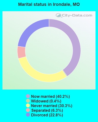
- Never married: 30.3%
- Now married: 40.2%
- Separated: 6.3%
- Widowed: 0.4%
- Divorced: 22.8%
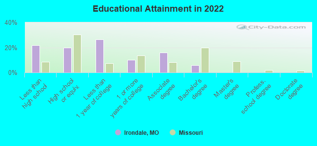
For population 25 years and over in Irondale:
- High school or higher: 76.7%
- Bachelor's degree or higher: 5.6%
- Graduate or professional degree: 0.0%
- Unemployed: 6.4%
- Mean travel time to work (commute): 22.3 minutes
| Here: | 7.1 |
| Missouri average: | 11.1 |
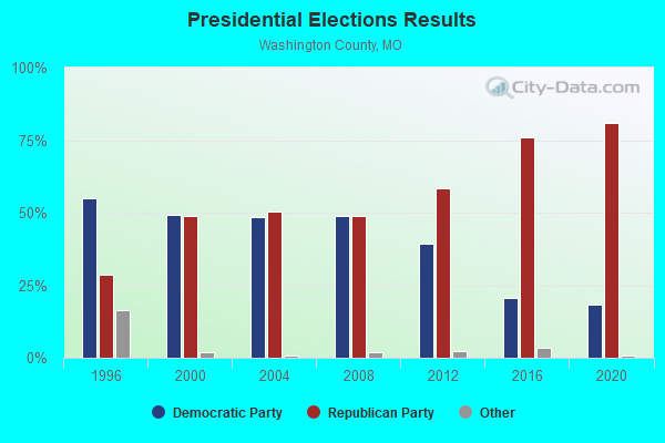
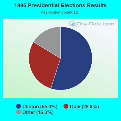
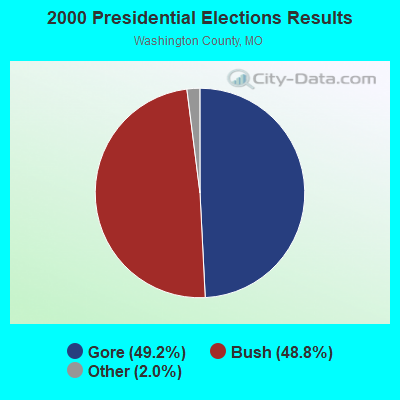

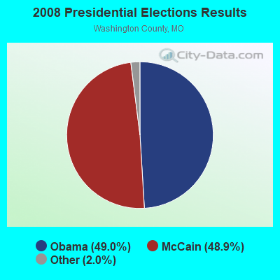
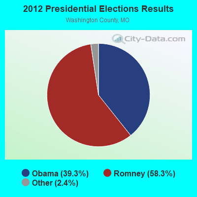

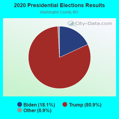
Graphs represent county-level data. Detailed 2008 Election Results
Religion statistics for Irondale, MO (based on Washington County data)
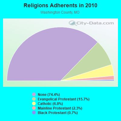
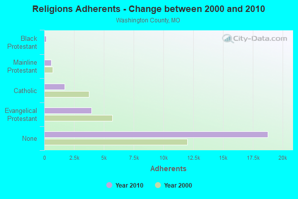
| Religion | Adherents | Congregations |
|---|---|---|
| Evangelical Protestant | 3,961 | 31 |
| Catholic | 1,707 | 4 |
| Mainline Protestant | 584 | 6 |
| Black Protestant | 184 | 1 |
| Other | 8 | 1 |
| None | 18,751 | - |
Food Environment Statistics:
| This county: | 1.24 / 10,000 pop. |
| Missouri: | 1.88 / 10,000 pop. |
| Washington County: | 0.41 / 10,000 pop. |
| State: | 0.60 / 10,000 pop. |
| Washington County: | 4.94 / 10,000 pop. |
| State: | 4.34 / 10,000 pop. |
| Here: | 3.29 / 10,000 pop. |
| Missouri: | 7.37 / 10,000 pop. |
| Washington County: | 8.9% |
| State: | 8.8% |
| Washington County: | 31.5% |
| Missouri: | 29.6% |
| Washington County: | 13.0% |
| State: | 13.5% |
Health and Nutrition:
| Irondale: | 50.7% |
| Missouri: | 50.9% |
| This city: | 49.9% |
| State: | 48.6% |
| This city: | 27.2 |
| State: | 28.7 |
| Irondale: | 18.5% |
| Missouri: | 20.6% |
| Irondale: | 17.3% |
| Missouri: | 10.1% |
| Here: | 6.5 |
| State: | 6.8 |
| Irondale: | 27.7% |
| Missouri: | 34.3% |
| Here: | 54.7% |
| Missouri: | 57.5% |
| Irondale: | 81.8% |
| Missouri: | 79.3% |
More about Health and Nutrition of Irondale, MO Residents
| Local government employment and payroll (March 2022) | |||||
| Function | Full-time employees | Monthly full-time payroll | Average yearly full-time wage | Part-time employees | Monthly part-time payroll |
|---|---|---|---|---|---|
| Financial Administration | 2 | $6,464 | $38,784 | 0 | $0 |
| Streets and Highways | 2 | $10,011 | $60,066 | 0 | $0 |
| Totals for Government | 4 | $16,475 | $49,425 | 0 | $0 |
Irondale government finances - Expenditure in 2017 (per resident):
- Current Operations - Police Protection: $49,000 ($133.51)
Central Staff Services: $26,000 ($70.84)
Financial Administration: $13,000 ($35.42)
Solid Waste Management: $7,000 ($19.07)
Water Utilities: $7,000 ($19.07)
Judicial and Legal Services: $7,000 ($19.07)
Regular Highways: $6,000 ($16.35)
Sewerage: $2,000 ($5.45)
Local Fire Protection: $1,000 ($2.72)
- Other Capital Outlay - Local Fire Protection: $2,000 ($5.45)
Water Utilities: $1,000 ($2.72)
- Total Salaries and Wages: $94,000 ($256.13)
Irondale government finances - Revenue in 2017 (per resident):
- Charges - Sewerage: $55,000 ($149.86)
- Miscellaneous - Fines and Forfeits: $8,000 ($21.80)
- Revenue - Water Utilities: $63,000 ($171.66)
- State Intergovernmental - Highways: $28,000 ($76.29)
- Tax - General Sales and Gross Receipts: $56,000 ($152.59)
Property: $44,000 ($119.89)
Motor Vehicle License: $18,000 ($49.05)
Public Utilities Sales: $3,000 ($8.17)
Occupation and Business License - Other: $1,000 ($2.72)
Irondale government finances - Cash and Securities in 2017 (per resident):
- Other Funds - Cash and Securities: $30,000 ($81.74)
Businesses in Irondale, MO
- MasterBrand Cabinets: 2
Strongest AM radio stations in Irondale:
- KFMO (1240 AM; 1 kW; FLAT RIVER, MO; Owner: M. K. S. BROADCASTING, INC.)
- KXEN (1010 AM; 50 kW; FESTUS-ST. LOUIS, MO; Owner: BDJ RADIO ENTERPRISES, LLC)
- KMOX (1120 AM; 50 kW; ST. LOUIS, MO; Owner: INFINITY BROADCASTING OPERATIONS, INC.)
- KREI (800 AM; 1 kW; FARMINGTON, MO; Owner: KREI, INC.)
- WSDZ (1260 AM; 20 kW; BELLEVILLE, IL)
- KYRO (1280 AM; 0 kW; POTOSI, MO; Owner: SAVOY BROADCASTING CO.)
- KTRS (550 AM; 5 kW; ST. LOUIS, MO; Owner: KTRS-AM LICENSE, L.L.C.)
- WCRV (640 AM; 50 kW; COLLIERVILLE, TN; Owner: BOTT BROADCASTING COMPANY/TENNESSEE)
- KRFT (1190 AM; 10 kW; DE SOTO, MO; Owner: ALL SPORTS RADIO, LLC)
- KJSL (630 AM; 5 kW; ST. LOUIS, MO; Owner: WMUZ RADIO, INC.)
- KFUO (850 AM; 5 kW; CLAYTON, MO; Owner: LUTHERAN CHURCH-MISSOURI SYNOD)
- WDIA (1070 AM; 50 kW; MEMPHIS, TN; Owner: CLEAR CHANNEL BROADCASTING LICENSES, INC.)
- WGSF (1030 AM; 50 kW; MEMPHIS, TN; Owner: FLINN BROADCASTING CORPORATION)
Strongest FM radio stations in Irondale:
- KDBB (104.3 FM; BONNE TERRE, MO; Owner: MKS BROADCASTING, INC.)
- KHZR (97.7 FM; POTOSI, MO; Owner: FOUR HIM ENTERPRISES, L.L.C.)
- KBGM (91.1 FM; PARK HILLS, MO; Owner: AMERICAN FAMILY ASSOCIATION)
- KTJJ (98.5 FM; FARMINGTON, MO; Owner: KREI, INC.)
- KYLS-FM (95.9 FM; IRONTON, MO; Owner: DOCKINS COMMUNICATIONS, INC.)
- KPNT (105.7 FM; ST. GENEVIEVE, MO; Owner: EMMIS RADIO LICENSE CORPORATION)
- KNLP (89.7 FM; POTOSI, MO; Owner: NEW LIFE EVANGELISTIC CENTER, INC.)
- KNSX (93.3 FM; STEELVILLE, MO; Owner: TWENTY-ONE SOUND COMMUNICATIONS, INC)
- KDJR (100.1 FM; DE SOTO, MO; Owner: KDJR RADIO, INC.)
- KNLH (89.5 FM; CEDAR HILL, MO; Owner: NEW LIFE EVANGELISTIC CENTER, INC.)
TV broadcast stations around Irondale:
- KNLC (Channel 24; ST. LOUIS, MO; Owner: NEW LIFE EVANGELISTIC CENTER, INC.)
- WRBU (Channel 46; EAST ST. LOUIS, IL; Owner: ROBERTS BROADCASTING COMPANY)
Irondale fatal accident list:
Aug 11, 1993 11:15 PM, M, Vehicles: 1, Persons: 1, Fatalities: 1, Drunk persons involved: 1
- National Bridge Inventory (NBI) Statistics
- 11Number of bridges
- 121ft / 36.8mTotal length
- $908,000Total costs
- 6,690Total average daily traffic
- 586Total average daily truck traffic
- 9,290Total future (year 2040) average daily traffic
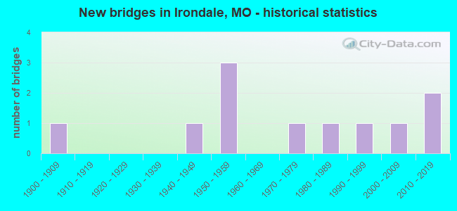
- New bridges - historical statistics
- 11900-1909
- 11940-1949
- 31950-1959
- 11970-1979
- 11980-1989
- 11990-1999
- 12000-2009
- 22010-2019
FCC Registered Antenna Towers:
7- Donna-Marie Stipo, On Jayhawk Rd., Approx. 1,500ft E Of The Intersection With State Hwy U (Lat: 37.831889 Lon: -90.685778), Type: 103.6, Structure height: 29221 m, Overall height: 99.1 m, Registrant: Tillman Infrastructure, LLC, Dmstipo@tillmaninfrastructure.Com, 27th Floor, New Y-ork, Phone: (212) 706-1627
- Donna-Marie Stipo, On Jayhawk Rd., Approx. 1,500ft E Of The Intersection With State Hwy U (Lat: 37.831889 Lon: -90.685778), Type: 103.6, Structure height: 29221 m, Overall height: 99.1 m, Registrant: Tillman Infrastructure, LLC, Dmstipo@tillmaninfrastructure.Com, 27th Floor, New Y-ork, Phone: (212) 706-1627
- Donna-Marie Stipo, 10296 Jayhawk Rd (Lat: 37.831556 Lon: -90.685611), Type: 103.6, Structure height: 29221 m, Overall height: 99.1 m, Registrant: Tillman Infrastructure, LLC, Dmstipo@tillmaninfrastructure.Com, 27th Floor, New Y-ork, Phone: (212) 706-1627
- Donna-Marie Stipo, 10296 Jayhawk Rd (Lat: 37.831556 Lon: -90.685611), Type: 103.6, Structure height: 29221 m, Overall height: 99.1 m, Registrant: Tillman Infrastructure, LLC, Dmstipo@tillmaninfrastructure.Com, 27th Floor, New Y-ork, Phone: (212) 706-1627
- Donna-Marie Stipo, 10296 Jayhawk Rd (Lat: 37.831556 Lon: -90.685611), Type: 103.6, Structure height: 29221 m, Overall height: 99.1 m, Registrant: Tillman Infrastructure, LLC, Dmstipo@tillmaninfrastructure.Com, 27th Floor, New Y-ork, Phone: (212) 706-1627
- Donna-Marie Stipo, 10296 Jayhawk Rd (Lat: 37.831556 Lon: -90.685611), Type: 101.5, Structure height: 29221 m, Overall height: 99.1 m, Registrant: Tillman Infrastructure, LLC, Dmstipo@tillmaninfrastructure.Com, 27th Floor, New Y-ork, Phone: (212) 706-1627
- Donna-Marie Stipo, 10296 Jayhawk Rd (Lat: 37.831556 Lon: -90.685611), Type: 101.5, Structure height: 29221 m, Overall height: 99.1 m, Licensee ID: L, Registrant: Tillman Infrastructure, LLC, Dmstipo@tillmaninfrastructure.Com, 27th Floor, New Y-ork, Phone: (212) 706-1627
FCC Registered Microwave Towers:
2- IRONDALE, MO, 1/4 Mile North Of State Route M And 50' East Of County Road 512 (Lat: 37.841389 Lon: -90.668611), Type: Tank, Structure height: 21.3 m, Overall height: 27.4 m, Call Sign: WPVX243, Licensee ID: L00471460,
Assigned Frequencies: 942.575 MHz, Grant Date: 07/03/2012, Expiration Date: 08/28/2022, Cancellation Date: 12/11/2019, Certifier: James T Porter, Registrant: Washington County Central Dispatch 911
- Irondale, 1/4 Mile North Of State Route M And 50' East Of County Road 512 (Lat: 37.841222 Lon: -90.668278), Type: Tank, Structure height: 21.3 m, Overall height: 27.4 m, Call Sign: WRCS276,
Assigned Frequencies: 6389.96 MHz, 6389.96 MHz, 6389.96 MHz, 6389.96 MHz, 6389.96 MHz, 6389.96 MHz, Grant Date: 12/19/2018, Expiration Date: 12/19/2028, Certifier: William Goad, Registrant: Micronet Communications, Inc., 812 Lexington Dr, Plano, TX 75075, Phone: (972) 422-7200, Email:
FCC Registered Amateur Radio Licenses:
5- Call Sign: KA0SKR, Licensee ID: L00850668, Grant Date: 04/21/2004, Expiration Date: 05/10/2014, Cancellation Date: 05/11/2016, Certifier: Buford T Wells, Registrant: Buford T Wells, Rt 1 Box 153, Irondale, MO 63648
- Call Sign: KC0CIH, Grant Date: 12/01/1997, Expiration Date: 12/01/2007, Cancellation Date: 12/02/2009, Registrant: Marvin G Province, Rt 1 Box 115, Irondale, MO 63648
- Call Sign: KE0IKJ, Licensee ID: L02015105, Grant Date: 04/01/2016, Expiration Date: 04/01/2026, Certifier: James T Miller Jr, Registrant: James T Miller Jr, 20209 State Hwy N, Irondale, MO 63648
- Call Sign: KE0RWZ, Licensee ID: L02165053, Grant Date: 05/22/2018, Expiration Date: 05/22/2028, Certifier: Shaun P Mcbride, Registrant: Shaun P Mcbride, 400 Main Street, Irondale, MO 63653
- Call Sign: N9XRY, Previous Call Sign: KF0DCQ, Licensee ID: L02404558, Grant Date: 01/23/2021, Expiration Date: 01/23/2031, Certifier: Arthur F Smith, Registrant: Arthur F Smith, 17499 State Hwy U, Irondale, MO 63648
2002 - 2018 National Fire Incident Reporting System (NFIRS) incidents
- Fire incident types reported to NFIRS in Irondale, MO
- 22744.9%Structure Fires
- 22444.3%Outside Fires
- 418.1%Mobile Property/Vehicle Fires
- 142.8%Other
 According to the data from the years 2002 - 2018 the average number of fire incidents per year is 30. The highest number of fire incidents - 54 took place in 2014, and the least - 1 in 2004. The data has an increasing trend.
 When looking into fire subcategories, the most reports belonged to: Structure Fires (44.9%), and Outside Fires (44.3%).
| Most common first names in Irondale, MO among deceased individuals | ||
| Name | Count | Lived (average) |
|---|---|---|
| John | 17 | 75.0 years |
| William | 10 | 74.6 years |
| Charles | 10 | 72.6 years |
| Robert | 9 | 66.0 years |
| James | 7 | 70.2 years |
| George | 7 | 71.8 years |
| Joseph | 6 | 79.2 years |
| Dorothy | 5 | 78.6 years |
| Clarence | 5 | 72.8 years |
| Lee | 5 | 73.2 years |
| Most common last names in Irondale, MO among deceased individuals | ||
| Last name | Count | Lived (average) |
|---|---|---|
| Province | 22 | 85.0 years |
| Smith | 8 | 68.7 years |
| French | 7 | 71.8 years |
| Horton | 6 | 75.5 years |
| Marler | 6 | 73.3 years |
| Brown | 5 | 76.8 years |
| Hampton | 5 | 82.2 years |
| Blackwell | 4 | 75.2 years |
| Robinson | 4 | 74.5 years |
| Martin | 4 | 80.5 years |
- 74.7%Electricity
- 13.9%Wood
- 9.6%Bottled, tank, or LP gas
- 1.8%Utility gas
- 79.2%Electricity
- 15.1%Bottled, tank, or LP gas
- 5.7%Utility gas
Irondale compared to Missouri state average:
- Median household income significantly below state average.
- Median house value below state average.
- Unemployed percentage below state average.
- Black race population percentage significantly below state average.
- Hispanic race population percentage significantly below state average.
- Foreign-born population percentage below state average.
- Renting percentage below state average.
- Length of stay since moving in above state average.
- Percentage of population with a bachelor's degree or higher significantly below state average.