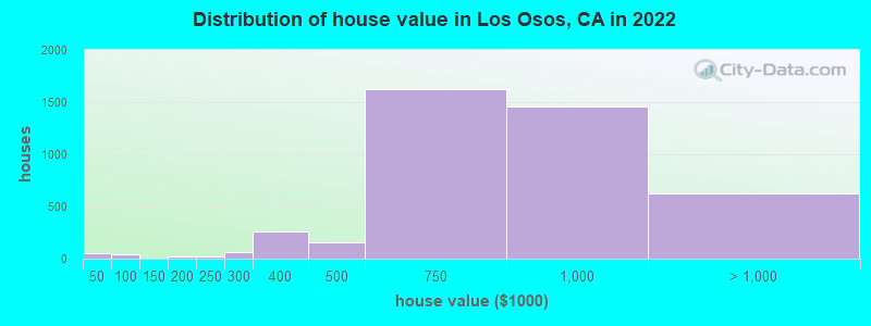
Estimated median house or condo value in 2022: $776,400
Los Osos:
$776,400
CA:
$715,900
Mean prices in 2022:all housing units: $861,591; detached houses: $926,520; townhouses or other attached units: $794,404; in 2-unit structures: $747,795; mobile homes: $272,576
Median gross rent in 2022: $1,880.
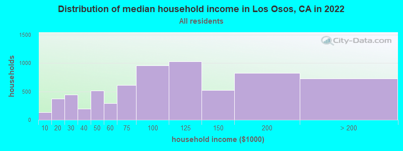
March 2022 cost of living index in Los Osos: 102.4 (near average, U.S. average is 100)Percentage of residents living in poverty in 2022: 9.4%
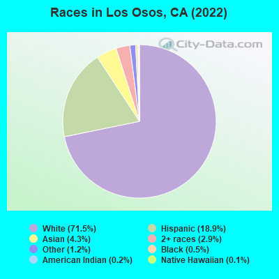
(6.7% for White Non-Hispanic residents, 10.4% for Black residents, 18.3% for Hispanic or Latino residents, 29.9% for American Indian residents, 31.7% for other race residents, 22.8% for two or more races residents)
170.1%Native Hawaiian and Other Pacific Islander alone
According to our research of California and other state lists, there were 18 registered sex offenders living in Los Osos, California as of April 25, 2024. The ratio of all residents to sex offenders in Los Osos is 880 to 1. The ratio of registered sex offenders to all residents in this city is near the state average.
Recent articles from our blog. Our writers, many of them Ph.D. graduates or candidates, create easy-to-read articles on a wide variety of topics.
Ancestries: Irish (10.3%), English (10.2%), European (8.3%), American (7.4%), German (6.6%), Eastern European (2.5%).
Current Local Time: PST time zone
Elevation: 126 feet
1,273 residents are foreign born (3.0% Asia, 3.0% Latin America, 1.6% Europe).
This place:
8.2%
California:
26.5%
Median real estate property taxes paid for housing units with mortgages in 2022: $6,710 (0.9%) Median real estate property taxes paid for housing units with no mortgage in 2022: $5,055 (0.7%)
Nearest city with pop. 50,000+: Santa Maria, CA (33.6 miles , pop. 77,423).
Nearest city with pop. 200,000+: Bakersfield, CA (101.6 miles , pop. 247,057).
Nearest city with pop. 1,000,000+: Los Angeles, CA (163.3 miles , pop. 3,694,820).
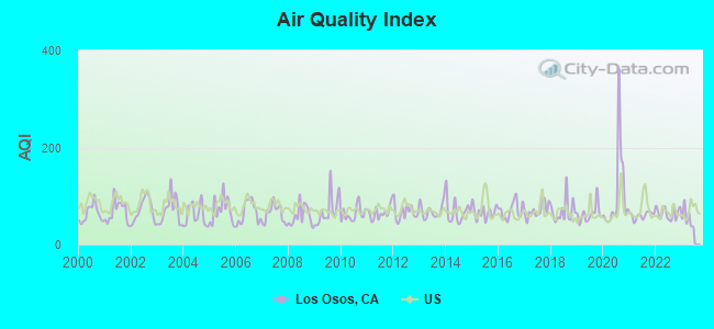
Air Quality Index (AQI) level in 2022 was 64.9. This is about average.
City:
64.9
U.S.:
72.6
Carbon Monoxide (CO) [ppm] level in 2005 was 0.205. This is better than average.Closest monitor was 9.8 miles away from the city center.
City:
0.205
U.S.:
0.251
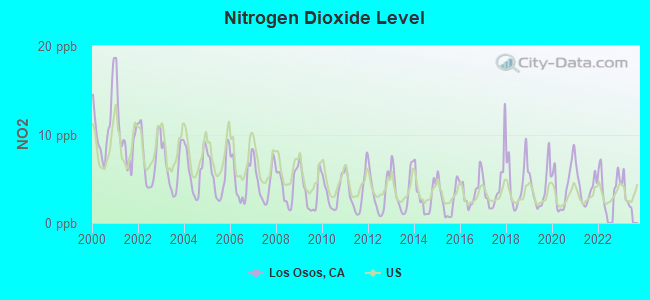
Nitrogen Dioxide (NO2) [ppb] level in 2022 was 4.36. This is about average.Closest monitor was 3.6 miles away from the city center.
City:
4.36
U.S.:
5.11
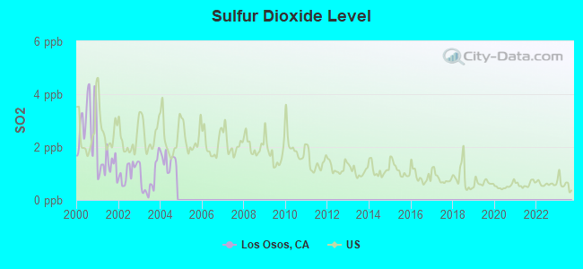
Sulfur Dioxide (SO2) [ppb] level in 2004 was 1.48. This is about average.Closest monitor was 3.6 miles away from the city center.
City:
1.48
U.S.:
1.51
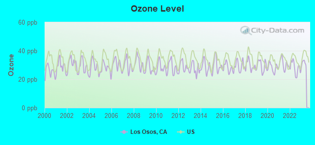
Ozone [ppb] level in 2022 was 28.1. This is about average.Closest monitor was 3.5 miles away from the city center.
City:
28.1
U.S.:
33.3
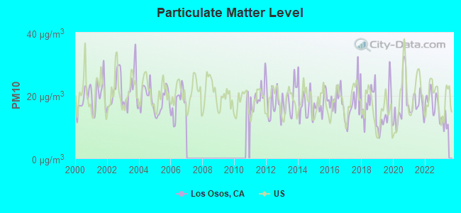
Particulate Matter (PM10) [µg/m3] level in 2022 was 17.8. This is about average.Closest monitor was 3.9 miles away from the city center.
City:
17.8
U.S.:
19.2
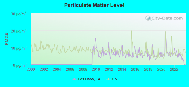
Particulate Matter (PM2.5) [µg/m3] level in 2022 was 6.53. This is better than average.Closest monitor was 9.9 miles away from the city center.
City:
6.53
U.S.:
8.11
Earthquake activity:
Los Osos-area historical earthquake activity is significantly above California state average. It is 6765% greater than the overall U.S. average.
On 11/4/1927 at 13:51:53, a magnitude 7.5 (7.5 UK, Class: Major, Intensity: VIII - XII) earthquake occurred 29.6 miles away from the city center On 7/21/1952 at 11:52:14, a magnitude 7.7 (7.7 UK) earthquake occurred 105.8 miles away from the city center, causing $50,000,000 total damage On 4/18/1906 at 13:12:21, a magnitude 7.9 (7.9 UK) earthquake occurred 221.5 miles away from the city center, causing $524,000,000 total damage On 10/18/1989 at 00:04:15, a magnitude 7.1 (6.5 MB, 7.1 MS, 6.9 MW, 7.0 ML) earthquake occurred 135.0 miles away from Los Osos center, causing 62 deaths (62 shaking deaths) and 3757 injuries, causing $1,305,032,704 total damage On 6/28/1992 at 11:57:34, a magnitude 7.6 (6.2 MB, 7.6 MS, 7.3 MW, Depth: 0.7 mi) earthquake occurred 256.5 miles away from Los Osos center, causing 3 deaths (1 shaking deaths, 2 other deaths) and 400 injuries, causing $100,000,000 total damage and $40,000,000 insured losses On 12/22/2003 at 19:15:56, a magnitude 6.6 (6.1 MB, 6.4 MS, 6.6 MW, 6.4 MW, Class: Strong, Intensity: VII - IX) earthquake occurred 25.2 miles away from the city center, causing 2 deaths (2 shaking deaths) and 40 injuries, causing $200,000,000 total damage Magnitude types: body-wave magnitude (MB), local magnitude (ML), surface-wave magnitude (MS), moment magnitude (MW)
Natural disasters:
The number of natural disasters in San Luis Obispo County (20) is greater than the US average (15). Major Disasters (Presidential) Declared: 14 Emergencies Declared: 2
Causes of natural disasters: Floods: 14, Storms: 7, Winter Storms: 7, Mudslides: 5, Landslides: 3, Drought: 1, Earthquake: 1, Fire: 1, Freeze: 1, Hurricane: 1, Tornado: 1, Other: 1 (Note: some incidents may be assigned to more than one category).
Hospitals and medical centers near Los Osos:
BAYSIDE CARE CENTER (Nursing Home, about 4 miles away; MORRO BAY, CA)
SIERRA VISTA REGIONAL MEDICAL CENTER Acute Care Hospitals (about 10 miles away; SAN LUIS OBISPO, CA)
BESTCARE CENTRAL COAST HHA (Home Health Center, about 10 miles away; SAN LUIS OBISPO, CA)
HOSPICE PARTNERS OF THE CENTRAL COAST (Hospital, about 10 miles away; SAN LUIS OBISPO, CA)
MAXIM HEALTHCARE SERVICES INC (Home Health Center, about 10 miles away; SAN LUIS OBISPO, CA)
CHUPARROSA STREET HOME (Hospital, about 10 miles away; SAN LUIS OBISPO, CA)
GENTIVA HEALTH SERVICES (Home Health Center, about 10 miles away; SAN LUIS OBISPO, CA)
Amtrak stations near Los Osos:
11 miles: SAN LUIS OBISPO-CAL POLY (SAN LUIS OBISPO, GRAND AVE.) - Bus Station . Services: fully wheelchair accessible, public payphones, full-service food facilities, call for car rental service, call for taxi service.
11 miles: SAN LUIS OBISPO (RAILROAD AVE & SANTA ROSA ST.) . Services: ticket office, fully wheelchair accessible, enclosed waiting area, public restrooms, public payphones, vending machines, free short-term parking, free long-term parking, call for car rental service, call for taxi service, public transit connection.
16 miles: ATASCADERO (EAST MALL & PALMA AVE.) - Bus Station . Services: fully wheelchair accessible, public payphones, taxi stand.
Operable nuclear power plants near Los Osos:
11 miles: Diablo Canyon 1 and 2 in Avila Beach, CA.
Colleges/universities with over 2000 students nearest to Los Osos:
Cuesta College (about 6 miles; San Luis Obispo, CA; Full-time enrollment: 6,518)
California Polytechnic State University-San Luis Obispo (about 10 miles; San Luis Obispo, CA; FT enrollment: 17,345)
Allan Hancock College (about 35 miles; Santa Maria, CA; FT enrollment: 6,639)
Taft College (about 79 miles; Taft, CA; FT enrollment: 2,121)
University of California-Santa Barbara (about 84 miles; Santa Barbara, CA; FT enrollment: 22,806)
West Hills College-Lemoore (about 89 miles; Lemoore, CA; FT enrollment: 2,314)
Santa Barbara City College (about 90 miles; Santa Barbara, CA; FT enrollment: 12,568)
Public elementary/middle schools in Los Osos:
LOS OSOS MIDDLE(Students: 345, Location: 1555 EL MORO ST., Grades: 6-8)
Notable locations in Los Osos: Baywood Park Farmers Market (A), Sea Pines Golf Course (B), South Bay Community Center (C), South Bay Branch San Luis Obispo City-County Library (D), Los Osos-Baywood Park Chamber of Commerce (E), California Department of Forestry and Fire Protection Station 15 - South Bay (F). Display/hide their locations on the map
Churches in Los Osos include: Baywood Park Community Church (A), El Morro Church of the Nazarene (B), First Baptist Church of Los Osos (C), Los Osos Valley Assembly of God Church (D), Saint Benedicts Episcopal Church (E), Saint Pauls Anglican Church (F), Trinity United Methodist Church (G). Display/hide their locations on the map
Parks in Los Osos include: Morro Coast Audubon Society Sweet Springs Nature Preserve (1), Elfin Forest Preserve (2). Display/hide their locations on the map
San Luis Obispo County has a predicted average indoor radon screening level between 2 and 4 pCi/L (pico curies per liter) - Moderate Potential
Average household size:
This place:
2.4 people
California:
2.9 people
Percentage of family households:
This place:
64.4%
Whole state:
68.7%
Percentage of households with unmarried partners:
This place:
6.4%
Whole state:
7.2%
Likely homosexual households (counted as self-reported same-sex unmarried-partner households)
Lesbian couples: 0.7% of all households
Gay men: 0.4% of all households
People in group quarters in Los Osos in 2010:
58 people in group homes intended for adults
10 people in nursing facilities/skilled-nursing facilities
9 people in workers' group living quarters and job corps centers
7 people in residential treatment centers for adults
Banks with branches in Los Osos (2011 data):
Rabobank, National Association: Los Osos Branch at 1001 Los Osos Valley Road, branch established on 1965/08/18. Info updated 2011/01/27: Bank assets: $11,745.0 mil, Deposits: $8,446.0 mil, headquarters in Roseville, CA, positive income, Agricultural Specialization, 124 total offices, Holding Company: Cooperatieve Centrale Raiffeisen-Boerenleenbank B.A., "rabobank Nederland
U.S. Bank National Association: Los Osos Ralphs Branch at 1240 Los Osos Valley Rd, branch established on 2001/03/09. Info updated 2012/01/30: Bank assets: $330,470.8 mil, Deposits: $236,091.5 mil, headquarters in Cincinnati, OH, positive income, 3121 total offices, Holding Company: U.S. Bancorp
JPMorgan Chase Bank, National Association: 1045 Los Osos Valley Road Branch at 1045 Los Osos Valley Road, branch established on 1919/01/01. Info updated 2011/11/10: Bank assets: $1,811,678.0 mil, Deposits: $1,190,738.0 mil, headquarters in Columbus, OH, positive income, International Specialization, 5577 total offices, Holding Company: Jpmorgan Chase & Co.
Coast National Bank: Los Osos Branch at 1193 Los Osos Valley Road, branch established on 1999/07/19. Info updated 2006/11/03: Bank assets: $132.2 mil, Deposits: $124.4 mil, headquarters in San Luis Obispo, CA, negative income in the last year, Commercial Lending Specialization, 5 total offices, Holding Company: Coast Bancorp
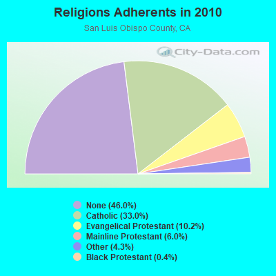
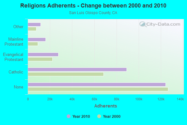
Religion statistics for Los Osos, CA (based on San Luis Obispo County data)
Religion
Adherents
Congregations
Catholic
89,075
17
Evangelical Protestant
27,483
138
Mainline Protestant
16,099
56
Other
11,530
47
Black Protestant
1,078
3
Orthodox
205
2
None
124,167
-
Source: Clifford Grammich, Kirk Hadaway, Richard Houseal, Dale E.Jones, Alexei Krindatch, Richie Stanley and Richard H.Taylor. 2012. 2010 U.S.Religion Census: Religious Congregations & Membership Study. Association of Statisticians of American Religious Bodies. Jones, Dale E., et al. 2002. Congregations and Membership in the United States 2000. Nashville, TN: Glenmary Research Center. Graphs represent county-level data
Food Environment Statistics:
Number of grocery stores: 60
Here:
2.29 / 10,000 pop.
California:
2.14 / 10,000 pop.
Number of supercenters and club stores: 1
This county:
0.04 / 10,000 pop.
California:
0.04 / 10,000 pop.
Number of convenience stores (no gas): 18
San Luis Obispo County:
0.69 / 10,000 pop.
California:
0.62 / 10,000 pop.
Number of convenience stores (with gas): 58
San Luis Obispo County:
2.22 / 10,000 pop.
California:
1.49 / 10,000 pop.
Number of full-service restaurants: 288
San Luis Obispo County:
11.00 / 10,000 pop.
California:
7.42 / 10,000 pop.
Adult diabetes rate:
San Luis Obispo County:
6.1%
California:
7.3%
Adult obesity rate:
San Luis Obispo County:
21.5%
California:
21.3%
Low-income preschool obesity rate:
Here:
14.5%
California:
17.9%
6.17% of this county's 2020 resident taxpayers moved to other counties in 2021 ($68,140 average adjusted gross income)
Here:
6.17%
California average:
6.14%
0.02% of residents moved to foreign countries ($212 average AGI)
San Luis Obispo County:
0.02%
California average:
0.02%
Top counties to which taxpayers relocated from this county between 2020 and 2021:
5,938Total future (year 2039) average daily traffic
FCC Registered Antenna Towers:
4
JOAN ROBBINS, 2865 Clark Valley Rd (Lat: 35.297222 Lon: -120.810556), Type: 16.7, Overall height: 16.7 m, Registrant: Gte Service Corporation, Scarmel@dcoffice.Gte.Com, , Washi-ngton, Phone: (202) 463-5295
Holly E Groschner, 2865 Clark Valley Rd (Lat: 35.297222 Lon: -120.810556), Type: 16.7, Overall height: 16.7 m, Registrant: Crown Castle Gt Company LLC, Shawn.Dunlap@crowncastle.Com, , Canon-sburg, Phone: (724) 416-2000
CHRISTINE A VERRE, 2865 Clark Valley Rd (Lat: 35.297222 Lon: -120.810556), Type: 16.7, Overall height: 16.7 m, Registrant: Crown Castle Gt Company LLC, Monica.Gambino@crowncastle.Com, , Canon-sburg, Phone: (724) 416-2516
2865 Clark Valley Rd (Lat: 35.297222 Lon: -120.810556), Type: 16.7, Overall height: 16.7 m, Registrant: Gte Mobilnet Of Santa Barbara Limited Partnership, Jrobbins@mobilnet.Gte.Com, , Atlan-ta, Phone: (770) 391-1732
FCC Registered Commercial Land Mobile Towers:
1
Los Padres Natl Forest (Lat: 35.360250 Lon: -120.655722), Structure height: 10 m, Call Sign: KPH935, Assigned Frequencies: 450.980 MHz, Grant Date: 02/12/1990, Expiration Date: 12/01/2013, Cancellation Date: 03/13/2012, Registrant: C/O Frontier Broadcast Holdings, 4311 Wilshire Boulevard, Suite 408, Los Angeles, CA 90010, Phone: (323) 964-5300, Email:
FCC Registered Private Land Mobile Towers:
1
2285 Clark Valley Rd (Lat: 35.296667 Lon: -120.810556), Type: Pole, Structure height: 16.8 m, Call Sign: WQML722, Assigned Frequencies: 855.837 MHz, Grant Date: 04/19/2004, Expiration Date: 04/23/2013, Cancellation Date: 03/08/2013, Certifier: Kim Christianson, Registrant: Motient Communications, Inc., 300 Knightsbridge Parkway, Lincolnshire, IL 60069, Phone: (847) 478-4212, Fax: (847) 478-4755, Email:
FCC Registered Broadcast Land Mobile Towers:
3
2285 Turri Road (Id 0727) (Lat: 35.321944 Lon: -120.800833), Type: Pipe, Structure height: 4 m, Overall height: 5 m, Call Sign: WQKW432, Assigned Frequencies: 169.487 MHz, Grant Date: 07/24/2019, Expiration Date: 10/06/2029, Certifier: Leland Armitage, Registrant: San Luis Obispo County It Communications, 1495 Kansas Ave, San Luis Obispo, CA 93405, Phone: (805) 781-5129, Email:
Los Osos Valley Rd, West Of Lariate Ave, East Of Eto Ln (Id 0751) (Lat: 35.305833 Lon: -120.811667), Type: Bridg, Structure height: 3 m, Call Sign: WQKW670, Assigned Frequencies: 169.487 MHz, Grant Date: 07/24/2019, Expiration Date: 10/08/2029, Certifier: Leland Armitage, Registrant: San Luis Obispo County It Communications, 1495 Kansas Ave, San Luis Obispo, CA 93405, Phone: (805) 781-5129, Email:
Lat: 35.325056 Lon: -120.819861, Call Sign: WROW300, Assigned Frequencies: 463.512 MHz, 463.812 MHz, 468.812 MHz, 468.512 MHz, 461.450 MHz, Grant Date: 12/20/2021, Expiration Date: 12/20/2031, Certifier: Chris Bonin, Registrant: Business Radio Licensing, 30251 Golden Lantern, Suite E, Laguna Niguel, CA 92677, Phone: (949) 348-8510, Fax: (949) 348-8514, Email:
FCC Registered Microwave Towers:
7
SF9036, 3770 Campbell Lane (Lat: 35.282250 Lon: -120.812861), Type: Pole, Structure height: 2.4 m, Call Sign: WQLN601, Assigned Frequencies: 19435.0 MHz, Grant Date: 03/16/2010, Expiration Date: 03/16/2020, Cancellation Date: 09/28/2018, Certifier: Dan Menser, Registrant: T-Mobile License LLC, 12920 Se 38th Street, Bellevue, WA 98006, Phone: (425) 383-5178, Fax: (425) 383-4840, Email:
CBS01, Lat: 35.317778 Lon: -120.850278, Type: Bant, Structure height: 8 m, Overall height: 9 m, Call Sign: WQNY886, Assigned Frequencies: 3650.00 MHz, Grant Date: 07/13/2011, Expiration Date: 07/13/2021, Cancellation Date: 07/27/2021, Certifier: Steve E Terry, Registrant: Wilson Creek Communications, LLC, 10210 Huer Huero Road, Creston, CA 93432, Phone: (805) 365-4522, Fax: (866) 801-8767, Email:
9th, Lat: 35.313972 Lon: -120.833778, Type: Pole, Structure height: 8 m, Overall height: 9 m, Call Sign: WQNY886, Assigned Frequencies: 3650.00 MHz, Grant Date: 07/13/2011, Expiration Date: 07/13/2021, Cancellation Date: 07/27/2021, Certifier: Steve E Terry, Registrant: Wilson Creek Communications, LLC, 10210 Huer Huero Road, Creston, CA 93432, Phone: (805) 365-4522, Fax: (866) 801-8767, Email:
SL06 - Clark Valley, 2983 Clark Valley Road (Lat: 35.282139 Lon: -120.812528), Type: Tower, Structure height: 12.2 m, Overall height: 15.5 m, Call Sign: WQOJ496, Assigned Frequencies: 6286.19 MHz, Grant Date: 10/18/2011, Expiration Date: 10/18/2021, Cancellation Date: 04/16/2013, Certifier: Robert Vitanza, Registrant: At&t Mobility LLC, 1120 20th Street, Nw - Suite 1000, Washington, DC 20036, Phone: (202) 457-2055, Fax: (202) 457-3073, Email:
SBL002, 2983 Clark Valley Road (Lat: 35.283806 Lon: -120.812778), Type: Pipe, Structure height: 5.2 m, Call Sign: WQPW350, Assigned Frequencies: 6645.00 MHz, Grant Date: 08/29/2012, Expiration Date: 08/29/2022, Cancellation Date: 01/29/2019, Certifier: John E Monday, Registrant: At&t Mobility LLC, 208 S Akard St., Rm 1015, Dallas, TX 75202, Phone: (855) 699-7073, Fax: (214) 746-6410, Email:
SLG06, 2983 Clark Valley Road Dup (Lat: 35.282139 Lon: -120.812528), Type: Ltower, Structure height: 12.2 m, Overall height: 15.5 m, Call Sign: WQUG633, Assigned Frequencies: 5945.20 MHz, 5974.85 MHz, 6004.50 MHz, 6034.15 MHz, Grant Date: 07/01/2014, Expiration Date: 07/01/2024, Certifier: John E Monday, Registrant: At&t Services, Inc., 208 S Akard St, 20f, Dallas, TX 75202, Phone: (855) 699-7073, Email:
LOSO, West Of Clark Valley Rd (Lat: 35.282139 Lon: -120.812583), Type: Pole, Structure height: 6 m, Overall height: 7 m, Call Sign: WRCC453, Assigned Frequencies: 11485.0 MHz, 11485.0 MHz, 10995.0 MHz, 10995.0 MHz, Grant Date: 08/23/2018, Expiration Date: 08/23/2028, Certifier: John Rees, Registrant: Intelpath, Hinsdale, IL 60522, Phone: (312) 841-9188, Email:


 Recent articles from our blog. Our writers, many of them Ph.D. graduates or candidates, create easy-to-read articles on a wide variety of topics.
 (33.6 miles