Onaqui, Utah
Submit your own pictures of this place and show them to the world
- OSM Map
- General Map
- Google Map
- MSN Map

| Males: 571 | |
| Females: 557 |
| Median resident age: | 36.0 years |
| Utah median age: | 27.1 years |
Zip code: 84071
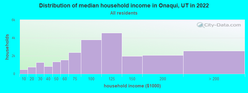
| Onaqui: | $90,342 |
| UT: | $89,168 |
Estimated per capita income in 2022: $33,206 (it was $14,572 in 2000)
Onaqui CCD income, earnings, and wages data
Estimated median house or condo value in 2022: $456,163 (it was $124,700 in 2000)
| Onaqui: | $456,163 |
| UT: | $499,500 |
Mean prices in 2022: all housing units: $368,559; detached houses: $381,588; townhouses or other attached units: $318,509; in 2-unit structures: $334,088; in 3-to-4-unit structures: $251,593; mobile homes: $62,959; occupied boats, rvs, vans, etc.: $106,021
Detailed information about poverty and poor residents in Onaqui, UT
Compare current foreclosures near your location:
| Photo | Address | Area | Beds / Baths | Price | Details |
|---|---|---|---|---|---|

|
#1
E 21st Ave
Columbus, OH 43211
|
1,061 sq. feet
|
1 baths 3 beds |
$187,900
|
show details |

|
#2
Bayberry Cir
Columbus, OH 43207
|
1,564 sq. feet
|
1 baths 3 beds |
$127,500
|
show details |

|
#3
S High St
Columbus, OH 43207
|
1,678 sq. feet
|
2 baths 4 beds |
$31,900
|
show details |

|
#4
Meadowbrook Dr
Columbus, OH 43207
|
1,752 sq. feet
|
2 baths 4 beds |
show details | |

|
#5
Bunch Flower Ct
Westerville, OH 43082
|
3,173 sq. feet
|
2 baths 4 beds |
show details | |

|
#6
Fergus Rd
Grove City, OH 43123
|
3,312 sq. feet
|
2 baths 4 beds |
show details | |

|
#7
Derrer Rd -872
Columbus, OH 43204
|
1,667 sq. feet
|
2 baths 5 beds |
show details | |

|
#8
S Richardson Ave
Columbus, OH 43204
|
1,520 sq. feet
|
2 baths 3 beds |
show details | |

|
#9
N Roys Ave
Columbus, OH 43204
|
1,248 sq. feet
|
2 baths 3 beds |
show details | |

|
#10
Ferris Rd
Columbus, OH 43224
|
2,218 sq. feet
|
3 baths 3 beds |
show details |
| Photo | Address | Area | Beds / Baths | Price | Details |
|---|---|---|---|---|---|

|
#11
S Chillicothe St
Plain City, OH 43064
|
1,736 sq. feet
|
2 baths 4 beds |
show details | |

|
#12
Striebel Ct
Columbus, OH 43227
|
925 sq. feet
|
1 baths 3 beds |
show details | |

|
#13
Mink St SW
Pataskala, OH 43062
|
1,442 sq. feet
|
1 baths 3 beds |
show details | |

|
#14
S Hague Ave
Columbus, OH 43204
|
979 sq. feet
|
1 baths 2 beds |
show details | |

|
#15
Vineyard Haven Loop
Dublin, OH 43016
|
4,625 sq. feet
|
4 baths 4 beds |
show details | |

|
#16
Marshrun Dr
Grove City, OH 43123
|
2,036 sq. feet
|
2 baths 4 beds |
show details | |

|
#17
Kingsglen Dr
Grove City, OH 43123
|
1,635 sq. feet
|
2 baths 4 beds |
show details | |

|
#18
Elaine Rd
Columbus, OH 43213
|
764 sq. feet
|
1 baths 2 beds |
show details | |

|
#19
Falls Peak Ln
Delaware, OH 43015
|
1,352 sq. feet
|
2 baths 2 beds |
show details | |

|
#20
E Welch Ave
Columbus, OH 43207
|
1,864 sq. feet
|
2 baths 4 beds |
show details |
| Photo | Address | Area | Beds / Baths | Price | Details |
|---|---|---|---|---|---|

|
#21
Wrexham Ave
Columbus, OH 43223
|
1,235 sq. feet
|
1 baths 3 beds |
show details | |

|
#22
Bretton Pl
Columbus, OH 43211
|
1,056 sq. feet
|
1 baths 3 beds |
show details | |

|
#23
Midland Ave
Columbus, OH 43223
|
1,518 sq. feet
|
1 baths 2 beds |
show details | |

|
#24
Mayflower Blvd
Columbus, OH 43213
|
1,591 sq. feet
|
2 baths 4 beds |
show details | |

|
#25
High Free Pike
West Jefferson, OH 43162
|
1,216 sq. feet
|
2 baths 4 beds |
show details | |

|
#26
Trotter Dr
Columbus, OH 43207
|
1,478 sq. feet
|
1 baths 3 beds |
show details | |

|
#27
Rosewood Ct
Powell, OH 43065
|
2,801 sq. feet
|
3 baths 4 beds |
show details | |

|
#28
Belle Oak Dr
Galloway, OH 43119
|
1,296 sq. feet
|
2 baths 3 beds |
show details | |

|
#29
Edgeview Rd
Columbus, OH 43207
|
1,700 sq. feet
|
1 baths 4 beds |
show details | |

|
#30
N Grener Ave
Columbus, OH 43228
|
1,120 sq. feet
|
1 baths 3 beds |
show details |
| Photo | Address | Area | Beds / Baths | Price | Details |
|---|---|---|---|---|---|

|
#31
Brookstone Dr
Westerville, OH 43082
|
1,783 sq. feet
|
3 baths 3 beds |
show details | |

|
#32
Hiawatha Park Dr
Columbus, OH 43211
|
1,278 sq. feet
|
1 baths 4 beds |
show details | |

|
#33
Bernadette Rd
Columbus, OH 43204
|
1,168 sq. feet
|
1 baths 3 beds |
show details | |

|
#34
Sleeping Meadow Dr
New Albany, OH 43054
|
3,211 sq. feet
|
2 baths 4 beds |
show details | |

|
#35
Scottwood Rd
Columbus, OH 43227
|
1,008 sq. feet
|
1 baths 3 beds |
show details | |

|
#36
Fahlander Dr N
Columbus, OH 43229
|
1,338 sq. feet
|
2 baths 3 beds |
show details | |

|
#37
Stoneybrook Blvd # 21a
Hilliard, OH 43026
|
1,231 sq. feet
|
2 baths 3 beds |
show details | |

|
#38
Keene Dr
Westerville, OH 43081
|
2,612 sq. feet
|
4 baths 6 beds |
show details | |

|
#39
Conway Dr
Columbus, OH 43227
|
1,232 sq. feet
|
1 baths 3 beds |
show details | |

|
#40
Mango Ln
Hilliard, OH 43026
|
1,024 sq. feet
|
1 baths 2 beds |
show details |
| Photo | Address | Area | Beds / Baths | Price | Details |
|---|---|---|---|---|---|

|
#41
Leap Rd
Hilliard, OH 43026
|
1,352 sq. feet
|
1 baths 3 beds |
show details | |

|
#42
Windy Hill Ln
Galloway, OH 43119
|
1,108 sq. feet
|
2 baths 3 beds |
show details | |

|
#43
Windy Hill Ln
Galloway, OH 43119
|
1,350 sq. feet
|
2 baths 3 beds |
show details | |

|
#44
Renford Ct
Powell, OH 43065
|
1,795 sq. feet
|
1 baths 3 beds |
show details | |

|
#45
Messner Dr
Hilliard, OH 43026
|
832 sq. feet
|
1 baths 2 beds |
show details | |

|
#46
Illinois Ave
Westerville, OH 43081
|
1,120 sq. feet
|
1 baths 3 beds |
show details | |

|
#47
Camhurst Ct
Galloway, OH 43119
|
1,969 sq. feet
|
2 baths 3 beds |
show details | |

|
#48
Falene Pl
Galloway, OH 43119
|
1,178 sq. feet
|
1 baths 3 beds |
show details | |

|
#49
Sethwick Rd
Dublin, OH 43016
|
2,087 sq. feet
|
2 baths 4 beds |
show details | |

|
Check over 1 million property listings on Foreclosure.com!
|
browse all offers | |||

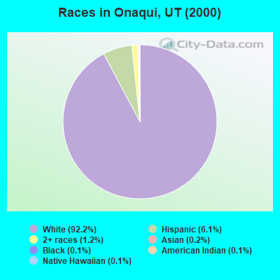
- 79192.2%White alone
- 526.1%Hispanic
- 101.2%Two or more races
- 20.2%Asian alone
- 10.1%Black alone
- 10.1%American Indian alone
- 10.1%Native Hawaiian and Other
Pacific Islander alone
Races in Onaqui detailed stats: ancestries, foreign born residents, place of birth
 Recent articles from our blog. Our writers, many of them Ph.D. graduates or candidates, create easy-to-read articles on a wide variety of topics.

Current Local Time: MST time zone
Land area: 691.0 square miles.
Population density: 1.6 people per square mile (very low).

| Onaqui CCD: | 0.4% ($531) |
| Utah: | 0.7% ($956) |
Nearest city with pop. 50,000+: West Jordan, UT  (34.4 miles , pop. 68,336).
Nearest city with pop. 200,000+: Las Vegas, NV (317.9 miles , pop. 478,434).
Nearest city with pop. 1,000,000+: Phoenix, AZ (461.3 miles , pop. 1,321,045).
Nearest cities:
), ), Latitude: 40.19 N, Longitude: 112.34 W
Area code commonly used in this area: 435

| Here: | 2.7% |
| Utah: | 2.5% |
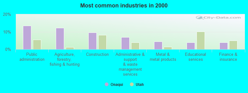
- Public administration (13.4%)
- Agriculture, forestry, fishing & hunting (12.2%)
- Construction (9.5%)
- Administrative & support & waste management services (6.8%)
- Metal & metal products (4.5%)
- Educational services (3.9%)
- Finance & insurance (3.9%)
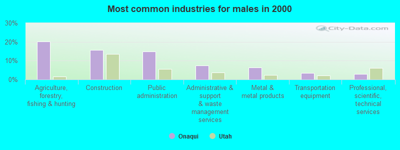
- Agriculture, forestry, fishing & hunting (20.2%)
- Construction (15.8%)
- Public administration (14.8%)
- Administrative & support & waste management services (7.4%)
- Metal & metal products (6.4%)
- Transportation equipment (3.4%)
- Professional, scientific, technical services (3.0%)
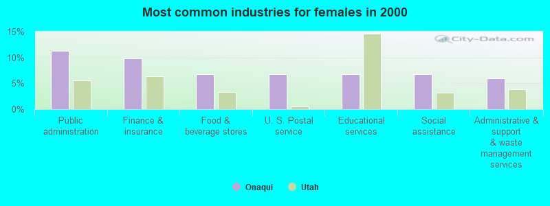
- Public administration (11.3%)
- Finance & insurance (9.8%)
- Food & beverage stores (6.8%)
- U. S. Postal service (6.8%)
- Educational services (6.8%)
- Social assistance (6.8%)
- Administrative & support & waste management services (6.0%)
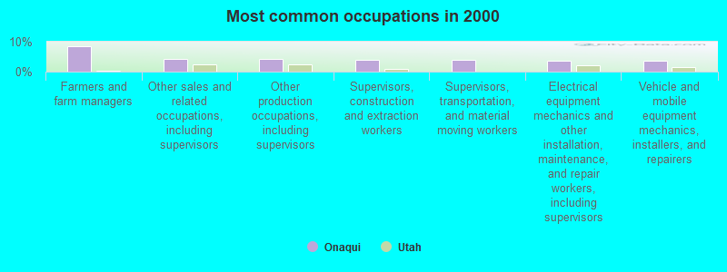
- Farmers and farm managers (8.6%)
- Other sales and related occupations, including supervisors (4.2%)
- Other production occupations, including supervisors (4.2%)
- Supervisors, construction and extraction workers (3.9%)
- Supervisors, transportation, and material moving workers (3.9%)
- Electrical equipment mechanics and other installation, maintenance, and repair workers, including supervisors (3.6%)
- Vehicle and mobile equipment mechanics, installers, and repairers (3.6%)
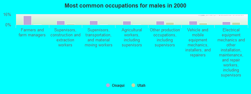
- Farmers and farm managers (14.3%)
- Supervisors, construction and extraction workers (6.4%)
- Supervisors, transportation, and material moving workers (6.4%)
- Agricultural workers, including supervisors (5.9%)
- Other production occupations, including supervisors (5.9%)
- Vehicle and mobile equipment mechanics, installers, and repairers (5.9%)
- Electrical equipment mechanics and other installation, maintenance, and repair workers, including supervisors (4.9%)
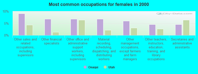
- Other sales and related occupations, including supervisors (9.0%)
- Other financial specialists (6.8%)
- Other office and administrative support workers, including supervisors (6.8%)
- Material recording, scheduling, dispatching, and distributing workers (6.8%)
- Other management occupations, except farmers and farm managers (6.0%)
- Other teachers, instructors, education, training, and library occupations (4.5%)
- Secretaries and administrative assistants (4.5%)
Average climate in Onaqui, Utah
Based on data reported by over 4,000 weather stations


(lower is better)
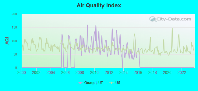
Air Quality Index (AQI) level in 2015 was 51.5. This is significantly better than average.
| City: | 51.5 |
| U.S.: | 72.6 |
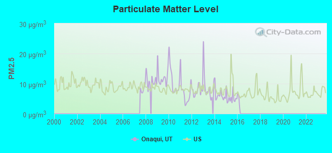
Particulate Matter (PM2.5) [µg/m3] level in 2015 was 5.27. This is significantly better than average. Closest monitor was 24.3 miles away from the city center.
| City: | 5.27 |
| U.S.: | 8.11 |
Earthquake activity:
Onaqui-area historical earthquake activity is significantly above Utah state average. It is 2381% greater than the overall U.S. average.On 10/3/1915 at 06:52:48, a magnitude 7.6 (7.6 UK, Class: Major, Intensity: VIII - XII) earthquake occurred 272.8 miles away from the city center
On 8/18/1959 at 06:37:13, a magnitude 7.7 (7.7 UK) earthquake occurred 314.4 miles away from Onaqui center, causing $26,000,000 total damage
On 10/28/1983 at 14:06:06, a magnitude 7.3 (6.2 MB, 7.3 MS, 7.0 MW) earthquake occurred 278.8 miles away from Onaqui center, causing 2 deaths (2 shaking deaths) and 3 injuries, causing $15,000,000 total damage
On 12/21/1932 at 06:10:09, a magnitude 7.2 (7.2 UK) earthquake occurred 328.4 miles away from the city center
On 3/28/1975 at 02:31:05, a magnitude 6.2 (6.1 MB, 6.0 MS, 6.2 ML, Class: Strong, Intensity: VII - IX) earthquake occurred 126.0 miles away from the city center
On 12/16/1954 at 11:07:12, a magnitude 7.0 (7.0 UK) earthquake occurred 308.9 miles away from the city center
Magnitude types: body-wave magnitude (MB), local magnitude (ML), surface-wave magnitude (MS), moment magnitude (MW)
Natural disasters:
The number of natural disasters in Tooele County (7) is smaller than the US average (15).Major Disasters (Presidential) Declared: 4
Emergencies Declared: 2
Causes of natural disasters: Floods: 4, Landslides: 3, Storms: 2, Drought: 1, Hurricane: 1, Mudslide: 1, Other: 1 (Note: some incidents may be assigned to more than one category).
Colleges/universities with over 2000 students nearest to Onaqui:
- Utah Valley University (about 34 miles; Orem, UT; Full-time enrollment: 24,403)
- Brigham Young University-Provo (about 37 miles; Provo, UT; FT enrollment: 33,525)
- Salt Lake Community College (about 40 miles; Salt Lake City, UT; FT enrollment: 20,797)
- Stevens-Henager College-Murray (about 40 miles; Murray, UT; FT enrollment: 6,395)
- Western Governors University (about 43 miles; Salt Lake City, UT; FT enrollment: 31,481)
- Westminster College (about 46 miles; Salt Lake City, UT; FT enrollment: 2,870)
- Latter-day Saints Business College (about 47 miles; Salt Lake City, UT; FT enrollment: 2,059)
Points of interest:
Notable locations in Onaqui: Youngs Ranch (A), Morgan Ranch (B), Dunbar (C), Jacob City (D), Saint John Station (E), Site of Rush Valley Pony Express Station (F), Bates Ranch (G), Dunbar (H), Benmore Experiment Station (I), Dry Farm (J), Sunshine (K), Boulter (L), Little Valley Campground (M), Clover Station (N), Benmore (O), Benmore Guard Station (P), Ophir Fire Department (Q), Rush Valley Fire Department (R), Vernon Fire Department (S). Display/hide their locations on the map
Church in Onaqui: The Church of Jesus Christ of Latter Day Saints (A). Display/hide its location on the map
Cemeteries: Chief Green Jacket Grave (1), Vernon Cemetery (2), Mercur Cemetery (3), Ophir Old Cemetery (4), Ophir New Cemetery (5), Clover Cemetery (6), Saint John Cemetery (7). Display/hide their locations on the map
Lakes and reservoirs: Dry Lake (A), Rush Lake (B), Vernon Reservoir (C), Atherley Reservoir (D). Display/hide their locations on the map
Streams, rivers, and creeks: South Fork Soldier Creek (A), Sabie Creek (B), Faust Creek (C), Dog Hollow Creek (D), Vernon Creek (E), Boulter Creek (F), Hickman Creek (G), Little Valley Creek (H), East Government Creek (I). Display/hide their locations on the map
Parks in Onaqui include: Historical Marker Faust Pony Express Station (1), Steptoe Historical Marker (2). Display/hide their locations on the map
| This place: | 3.0 people |
| Utah: | 3.1 people |
| This place: | 70.7% |
| Whole state: | 77.0% |
| This place: | 2.1% |
| Whole state: | 3.4% |
No gay or lesbian households reported
| This place: | 9.6% |
| Whole state: | 9.4% |
| This place: | 5.9% |
| Whole state: | 3.9% |
For population 15 years and over in Onaqui:
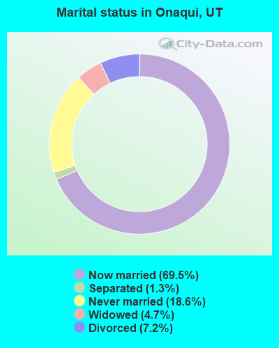
- Never married: 18.6%
- Now married: 69.5%
- Separated: 1.3%
- Widowed: 4.7%
- Divorced: 7.2%
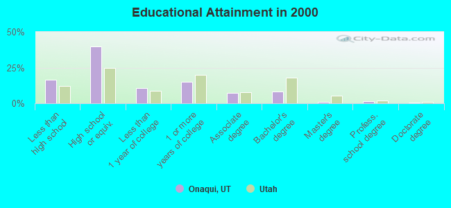
For population 25 years and over in Onaqui:
- High school or higher: 83.4%
- Bachelor's degree or higher: 10.6%
- Graduate or professional degree: 2.5%
- Unemployed: 3.7%
- Mean travel time to work (commute): 37.6 minutes
| Here: | 8.2 |
| Utah average: | 10.5 |
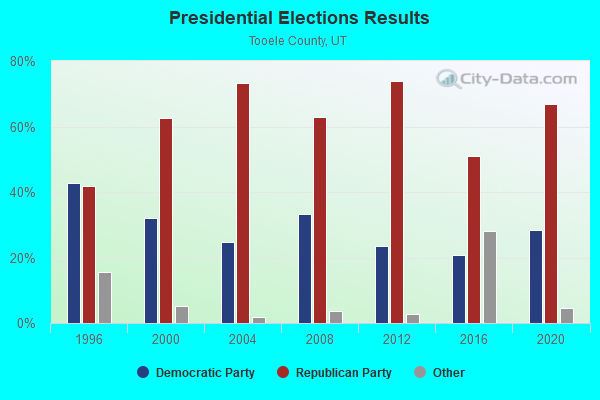
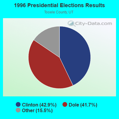
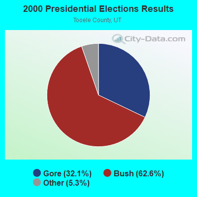
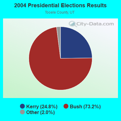
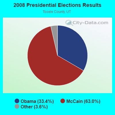
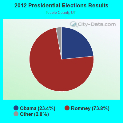
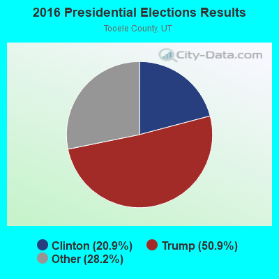
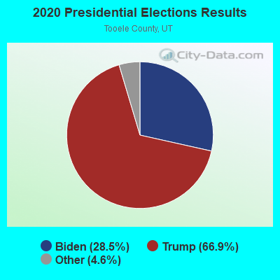
Graphs represent county-level data. Detailed 2008 Election Results
Religion statistics for Onaqui, UT (based on Tooele County data)
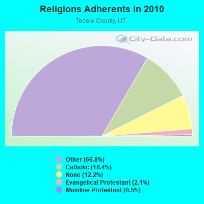
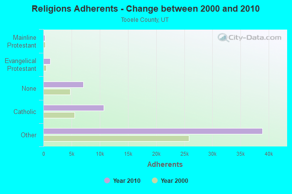
| Religion | Adherents | Congregations |
|---|---|---|
| Other | 38,895 | 88 |
| Catholic | 10,706 | 2 |
| Evangelical Protestant | 1,250 | 14 |
| Mainline Protestant | 293 | 2 |
| None | 7,074 | - |
Food Environment Statistics:
| Tooele County: | 1.28 / 10,000 pop. |
| State: | 1.37 / 10,000 pop. |
| This county: | 0.18 / 10,000 pop. |
| Utah: | 0.18 / 10,000 pop. |
| Here: | 0.55 / 10,000 pop. |
| Utah: | 0.41 / 10,000 pop. |
| Tooele County: | 2.37 / 10,000 pop. |
| State: | 2.82 / 10,000 pop. |
| Tooele County: | 2.37 / 10,000 pop. |
| Utah: | 5.09 / 10,000 pop. |
| Tooele County: | 7.9% |
| Utah: | 6.3% |
| Tooele County: | 28.6% |
| State: | 23.6% |
Strongest AM radio stations in Onaqui:
- KIQN (1010 AM; 50 kW; TOOELE, UT)
- KALL (700 AM; 50 kW; NORTH SALT LAKE CITY, UT; Owner: CITICASTERS LICENSES, L.P.)
- KSL (1160 AM; 50 kW; SALT LAKE CITY, UT; Owner: BONNEVILLE HOLDING COMPANY)
- KKDS (1060 AM; 10 kW; SOUTH SALT LAKE, UT; Owner: HOLIDAY BROADCASTING COMPANY)
- KTKK (630 AM; 10 kW; SANDY, UT; Owner: UNITED BROADCASTING COMPANY)
- KLLB (1510 AM; daytime; 10 kW; WEST JORDAN, UT; Owner: UNITED SECURITY FINANCIAL, INC.)
- KWDZ (910 AM; 5 kW; SALT LAKE CITY, UT; Owner: ABC, INC.)
- KBEE (860 AM; 10 kW; SALT LAKE CITY, UT; Owner: CITADEL BROADCASTING COMPANY)
- KMRI (1550 AM; 10 kW; WEST VALLEY CITY, UT; Owner: KMRI RADIO, LLC)
- KOVO (960 AM; 5 kW; PROVO, UT; Owner: MILLCREEK BROADCASTING LLC)
- KBJA (1640 AM; 10 kW; SANDY, UT; Owner: UNITED BROADCASTING COMPANY, INC)
- KNRS (570 AM; 5 kW; SALT LAKE CITY, UT; Owner: CITICASTERS LICENSES, L.P.)
- KZNS (1280 AM; 10 kW; SALT LAKE CITY, UT; Owner: SIMMONS-SLC, LS, LLC)
Strongest FM radio stations in Onaqui:
- KXRK (96.3 FM; PROVO, UT; Owner: SIMMONS-SLC, LS, LLC)
- KQMB (102.7 FM; MIDVALE, UT; Owner: SIMMONS-SLC, LS, LLC)
- KENZ (107.5 FM; OREM, UT; Owner: CITADEL BROADCASTING COMPANY)
- KZHT (94.9 FM; PROVO, UT; Owner: CITICASTERS LICENSES, L.P.)
- KUUU (92.1 FM; TOOELE, UT; Owner: MILLCREEK BROADCASTING, L.L.C.)
- KSOP-FM (104.3 FM; SALT LAKE CITY, UT; Owner: KSOP, INC.)
- K272DP (102.3 FM; TOOELE, UT; Owner: FAMILY STATIONS, INC.)
- KRCL (90.9 FM; SALT LAKE CITY, UT; Owner: LISTENERS COMMUNITY RADIO OF UTAH)
- KBZN (97.9 FM; OGDEN, UT; Owner: CAPITOL BROADCASTING, INC.)
- KOSY-FM (106.5 FM; SPANISH FORK, UT; Owner: MERCURY BROADCASTING COMPANY, INC.)
- KRSP-FM (103.5 FM; SALT LAKE CITY, UT; Owner: SIMMONS-SLC, LS, LLC)
- KBER (101.1 FM; OGDEN, UT; Owner: CITADEL BROADCASTING COMPANY)
- KISN-FM (97.1 FM; SALT LAKE CITY, UT; Owner: CLEAR CHANNEL BROADCASTING LICENSES, INC.)
- KKAT (101.9 FM; OGDEN, UT; Owner: CITICASTERS LICENSES, L.P.)
- KSFI (100.3 FM; SALT LAKE CITY, UT; Owner: SIMMONS-SLC, LS, LLC)
- KUBL-FM (93.3 FM; SALT LAKE CITY, UT; Owner: CITADEL BROADCASTING COMPANY)
- KODJ (94.1 FM; SALT LAKE CITY, UT; Owner: CITICASTERS LICENSES, L.P.)
- K217CL (91.3 FM; PROVO, UT; Owner: STOCKTON CHRISTIAN LIFE COLLEGE, INC)
- KUER-FM (90.1 FM; SALT LAKE CITY, UT; Owner: UNIVERSITY OF UTAH)
- KBYU-FM (89.1 FM; PROVO, UT; Owner: BRIGHAM YOUNG UNIVERSITY)
TV broadcast stations around Onaqui:
- KUTV (Channel 2; SALT LAKE CITY, UT; Owner: KUTV HOLDINGS, INC.)
- KUPX (Channel 16; PROVO, UT; Owner: PAXSON SALT LAKE CITY LICENSE, INC.)
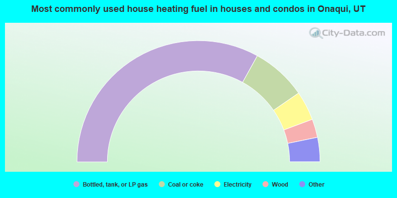
- 66.1%Bottled, tank, or LP gas
- 14.7%Coal or coke
- 7.8%Electricity
- 4.9%Wood
- 2.9%Other fuel
- 2.0%Fuel oil, kerosene, etc.
- 1.6%Utility gas
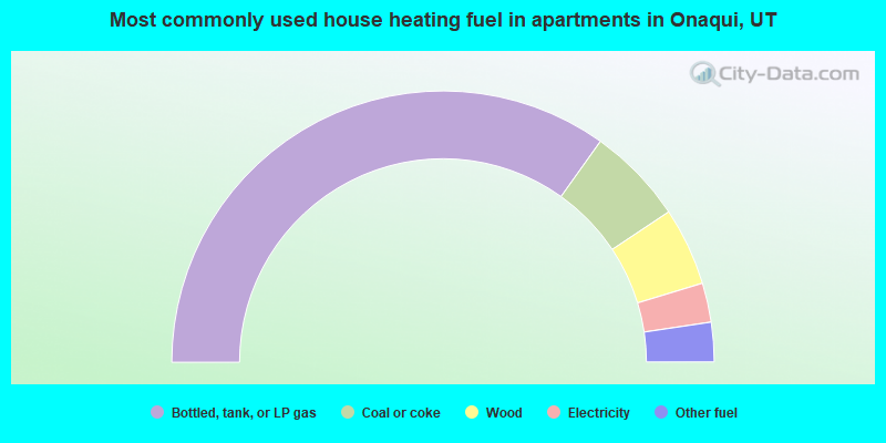
- 69.8%Bottled, tank, or LP gas
- 11.6%Coal or coke
- 9.3%Wood
- 4.7%Electricity
- 4.7%Other fuel
Onaqui compared to Utah state average:
- Unemployed percentage significantly below state average.
- Black race population percentage significantly below state average.
- Hispanic race population percentage below state average.
- Median age above state average.
- Foreign-born population percentage significantly below state average.
- Renting percentage significantly below state average.
- Length of stay since moving in significantly above state average.
- Number of rooms per house significantly below state average.
- House age significantly below state average.
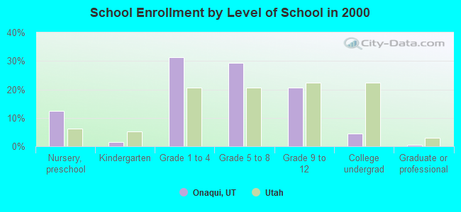
- Number of college students significantly below state average.
- Percentage of population with a bachelor's degree or higher below state average.