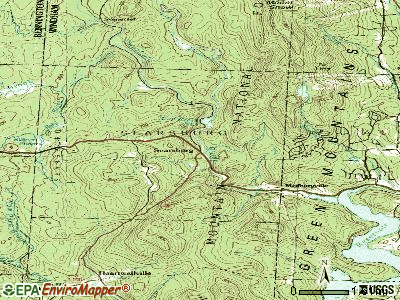
Searsburg, Vermont
Submit your own pictures of this town and show them to the world
- OSM Map
- General Map
- Google Map
- MSN Map

Population change since 2000: +13.5%
 |
| Males: 64 | |
| Females: 45 |
| Median resident age: | 44.5 years |
| Vermont median age: | 45.8 years |
Zip code: 05201
| Searsburg: | $30,040 |
| VT: | $73,991 |
Estimated per capita income in 2022: $19,894 (it was $10,472 in 2000)
Estimated median house or condo value in 2022: $207,999 (it was $86,700 in 2000)
| Searsburg: | $207,999 |
| VT: | $304,700 |
Mean prices in 2022: all housing units: $328,619; detached houses: $344,818; townhouses or other attached units: $277,995; in 2-unit structures: $228,670; in 3-to-4-unit structures: $413,467; in 5-or-more-unit structures: $239,659; mobile homes: $88,728
Detailed information about poverty and poor residents in Searsburg, VT
Compare current foreclosures near Searsburg, VT:
| Photo | Address | Area | Beds / Baths | Price | Details |
|---|---|---|---|---|---|

|
#1
Chapel Rd
Bennington, VT 05201
|
1,000 sq. feet
|
1 baths 2 beds |
$260,000
|
show details |

|
#2
Elmwood Ave
North Adams, MA 01247
|
2,777 sq. feet
|
3 baths 5 beds |
$215,000
|
show details |

|
#3
North St
North Adams, MA 01247
|
1,164 sq. feet
|
1 baths 3 beds |
show details | |

|
#4
Franklin St
North Adams, MA 01247
|
1,386 sq. feet
|
1 baths 3 beds |
show details | |

|
#5
Houghton St
North Adams, MA 01247
|
1,614 sq. feet
|
2 baths 4 beds |
show details | |

|
#6
Houghton St
North Adams, MA 01247
|
3,380 sq. feet
|
3 baths 5 beds |
show details | |

|
#7
North St
Williamstown, MA 01267
|
1,552 sq. feet
|
2 baths 3 beds |
show details | |

|
#8
Linden St
Williamstown, MA 01267
|
2,298 sq. feet
|
3 baths 4 beds |
show details | |

|
#9
Legate Hill Rd
Charlemont, MA 01339
|
2,016 sq. feet
|
2 baths 3 beds |
show details | |

|
#10
W Shaft Rd
North Adams, MA 01247
|
1,144 sq. feet
|
1 baths 3 beds |
show details |
| Photo | Address | Area | Beds / Baths | Price | Details |
|---|---|---|---|---|---|

|
#11
Church Rd
Drury, MA 01343
|
2,560 sq. feet
|
2 baths 4 beds |
show details | |

|
#12
North St
North Adams, MA 01247
|
1,164 sq. feet
|
1 baths 3 beds |
show details | |

|
#13
Mohawk Trl
North Adams, MA 01247
|
1,210 sq. feet
|
1 baths 3 beds |
show details | |

|
#14
Woodlawn Dr
Williamstown, MA 01267
|
1,806 sq. feet
|
2 baths 4 beds |
show details | |

|
#15
Number 9 Rd
Charlemont, MA 01339
|
2,058 sq. feet
|
2 baths 3 beds |
show details | |

|
#16
Franklin St
North Adams, MA 01247
|
1,386 sq. feet
|
1 baths 3 beds |
show details | |

|
#17
Phelps Rd
North Adams, MA 01247
|
1,286 sq. feet
|
1 baths 4 beds |
show details | |

|
#18
Union St # B
North Adams, MA 01247
|
- sq. feet
|
- baths - beds |
show details | |

|
#19
Ashland St Apt 201
North Adams, MA 01247
|
- sq. feet
|
- baths - beds |
show details | |

|
#20
Main St Apt 2
Bennington, VT 05201
|
- sq. feet
|
- baths - beds |
show details |
| Photo | Address | Area | Beds / Baths | Price | Details |
|---|---|---|---|---|---|

|
#21
South St
Bennington, VT 05201
|
- sq. feet
|
- baths - beds |
show details | |

|
#22
Dover Rd
South Newfane, VT 05351
|
- sq. feet
|
- baths - beds |
show details | |

|
#23
Fairgrounds Ave
North Adams, MA 01247
|
- sq. feet
|
- baths - beds |
show details | |

|
#24
Henderson Rd
Williamstown, MA 01267
|
- sq. feet
|
- baths - beds |
show details | |

|
#25
Tinkham Rd
North Bennington, VT 05257
|
- sq. feet
|
- baths - beds |
show details | |

|
#26
Dover Rd
Williamsville, VT 05362
|
- sq. feet
|
- baths - beds |
show details | |

|
#27
Old Cyrus Stage Rd
Rowe, MA 01367
|
- sq. feet
|
- baths - beds |
show details | |

|
#28
Eagle St Apt 402
North Adams, MA 01247
|
- sq. feet
|
- baths - beds |
show details | |

|
#29
Central Shaft Rd
North Adams, MA 01247
|
- sq. feet
|
- baths - beds |
show details | |

|
#30
Prospect St
North Adams, MA 01247
|
- sq. feet
|
- baths - beds |
show details |
| Photo | Address | Area | Beds / Baths | Price | Details |
|---|---|---|---|---|---|

|
#31
-96 Liberty St
North Adams, MA 01247
|
- sq. feet
|
- baths - beds |
show details | |

|
#32
Putnam St
Bennington, VT 05201
|
- sq. feet
|
- baths - beds |
show details | |

|
#33
Houghton Ln
Bennington, VT 05201
|
- sq. feet
|
- baths - beds |
show details | |

|
#34
Hillside St
Bennington, VT 05201
|
- sq. feet
|
- baths - beds |
show details | |

|
Check over 1 million property listings on Foreclosure.com!
|
browse all offers | |||

- 10596.3%White alone
- 21.8%Two or more races
- 10.9%Asian alone
- 10.9%Hispanic

According to our research of Vermont and other state lists, there was 1 registered sex offender living in Searsburg, Vermont as of May 21, 2024.
The ratio of all residents to sex offenders in Searsburg is 109 to 1.
 Recent articles from our blog. Our writers, many of them Ph.D. graduates or candidates, create easy-to-read articles on a wide variety of topics.


 | Official Vermont Picture Thread (966 replies) |
| Vermont Weather (3779 replies) |
| Areas of Vermont for a single male who wants to be alone? (27 replies) |
| Work in Bennington, Live in ??? (4 replies) |
Latest news from Searsburg, VT collected exclusively by city-data.com from local newspapers, TV, and radio stations
Ancestries: English (26.0%), German (18.8%), French (16.7%), Irish (13.5%), Polish (8.3%), Welsh (6.2%).
Current Local Time: EST time zone
Elevation: 1734 feet
Land area: 21.5 square miles.
Population density: 5.1 people per square mile (very low).

| Searsburg town: | 0.8% ($700) |
| Vermont: | 2.0% ($2,196) |
Nearest city with pop. 50,000+: Albany, NY  (44.5 miles , pop. 95,658).
Nearest city with pop. 200,000+: Boston, MA (103.2 miles , pop. 589,141).
Nearest city with pop. 1,000,000+: Bronx, NY (148.8 miles , pop. 1,332,650).
Nearest cities:
), ), Latitude: 42.89 N, Longitude: 72.96 W
Area code commonly used in this area: 802


| Here: | 3.4% |
| Vermont: | 2.0% |

Average climate in Searsburg, Vermont
Based on data reported by over 4,000 weather stations


(lower is better)

Air Quality Index (AQI) level in 2022 was 56.8. This is better than average.
| City: | 56.8 |
| U.S.: | 72.6 |

Ozone [ppb] level in 2022 was 29.1. This is about average. Closest monitor was 5.5 miles away from the city center.
| City: | 29.1 |
| U.S.: | 33.3 |

Particulate Matter (PM2.5) [µg/m3] level in 2022 was 5.72. This is significantly better than average. Closest monitor was 11.2 miles away from the city center.
| City: | 5.72 |
| U.S.: | 8.11 |
Tornado activity:
Searsburg-area historical tornado activity is significantly above Vermont state average. It is 33% smaller than the overall U.S. average.
On 5/31/1998, a category F3 (max. wind speeds 158-206 mph) tornado 11.3 miles away from the Searsburg town center injured 68 people and caused $71 million in damages.
On 8/20/1968, a category F3 tornado 16.8 miles away from the town center injured one person and caused between $5000 and $50,000 in damages.
Earthquake activity:
Searsburg-area historical earthquake activity is significantly above Vermont state average. It is 69% smaller than the overall U.S. average.On 10/7/1983 at 10:18:46, a magnitude 5.3 (5.1 MB, 5.3 LG, 5.1 ML, Class: Moderate, Intensity: VI - VII) earthquake occurred 101.0 miles away from Searsburg center
On 4/20/2002 at 10:50:47, a magnitude 5.3 (5.3 ML, Depth: 3.0 mi) earthquake occurred 118.1 miles away from the city center
On 4/20/2002 at 10:50:47, a magnitude 5.2 (5.2 MB, 4.2 MS, 5.2 MW, 5.0 MW) earthquake occurred 116.8 miles away from the city center
On 1/19/1982 at 00:14:42, a magnitude 4.7 (4.5 MB, 4.7 MD, 4.5 LG, Class: Light, Intensity: IV - V) earthquake occurred 80.7 miles away from Searsburg center
On 10/16/2012 at 23:12:25, a magnitude 4.7 (4.7 ML, Depth: 10.0 mi) earthquake occurred 126.1 miles away from Searsburg center
On 6/17/1991 at 08:53:16, a magnitude 4.1 (4.0 MB, 4.0 LG, Depth: 3.1 mi) earthquake occurred 88.9 miles away from the city center
Magnitude types: regional Lg-wave magnitude (LG), body-wave magnitude (MB), duration magnitude (MD), local magnitude (ML), surface-wave magnitude (MS), moment magnitude (MW)
Natural disasters:
The number of natural disasters in Bennington County (15) is near the US average (15).Major Disasters (Presidential) Declared: 10
Emergencies Declared: 2
Causes of natural disasters: Floods: 8, Storms: 8, Tropical Storms: 2, Winter Storms: 2, Hurricane: 1, Landslide: 1, Snowstorm: 1, Wind: 1, Other: 1 (Note: some incidents may be assigned to more than one category).
Hospitals and medical centers near Searsburg:
- CRESCENT MANOR CARE CTRS (Nursing Home, about 12 miles away; BENNINGTON, VT)
- VERMONT VETERANS HOME (Nursing Home, about 12 miles away; BENNINGTON, VT)
- VNA AND HOSPICE OF SVHC (Home Health Center, about 13 miles away; BENNINGTON, VT)
- SOUTHWESTERN VERMONT MEDICAL CENTER Acute Care Hospitals (about 13 miles away; BENNINGTON, VT)
- BENNINGTON CONVEALESCENT CTR (Nursing Home, about 13 miles away; BENNINGTON, VT)
- BENNINGTON HEALTH AND REHAB (Nursing Home, about 13 miles away; BENNINGTON, VT)
- CENTERS FOR LIVING AND REHAB (Nursing Home, about 13 miles away; BENNINGTON, VT)
Colleges/universities with over 2000 students nearest to Searsburg:
- Williams College (about 18 miles; Williamstown, MA; Full-time enrollment: 2,141)
- Keene State College (about 35 miles; Keene, NH; FT enrollment: 5,098)
- Rensselaer Polytechnic Institute (about 38 miles; Troy, NY; FT enrollment: 6,940)
- The Sage Colleges (about 39 miles; Troy, NY; FT enrollment: 2,499)
- Hudson Valley Community College (about 39 miles; Troy, NY; FT enrollment: 9,346)
- University of Massachusetts-Amherst (about 42 miles; Amherst, MA; FT enrollment: 26,583)
- Siena College (about 42 miles; Loudonville, NY; FT enrollment: 3,153)
Points of interest:
Notable location: Searsburg Town Hall (A). Display/hide its location on the map
Cemeteries: Cutler Cemetery (1), Eames Cemetery (2), Fairington Cemetery (3). Display/hide their locations on the map
Lakes and reservoirs: Billings Pond (A), Searsburg Reservoir (B). Display/hide their locations on the map
Streams, rivers, and creeks: Vose Brook (A), Redfield Brook (B), Red Mill Pond Brook (C), Pine Brook (D), Bond Brook (E), East Branch Deerfield River (F), Medbury Brook (G), Heather Brook (H). Display/hide their locations on the map
| This town: | 2.5 people |
| Vermont: | 2.3 people |
| This town: | 68.2% |
| Whole state: | 62.5% |
| This town: | 11.4% |
| Whole state: | 9.2% |
Likely homosexual households (counted as self-reported same-sex unmarried-partner households)
- Lesbian couples: 0.0% of all households
- Gay men: 2.3% of all households
| This town: | 17.5% |
| Whole state: | 9.4% |
| This town: | 10.5% |
| Whole state: | 3.6% |
For population 15 years and over in Searsburg:

- Never married: 34.0%
- Now married: 46.8%
- Separated: 0.0%
- Widowed: 12.8%
- Divorced: 6.4%
For population 25 years and over in Searsburg:
- High school or higher: 74.3%
- Bachelor's degree or higher: 0.0%
- Graduate or professional degree: 0.0%
- Unemployed: 7.4%
- Mean travel time to work (commute): 14.4 minutes


| Here: | 4.3 |
| Vermont average: | 11.7 |
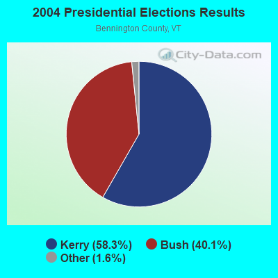
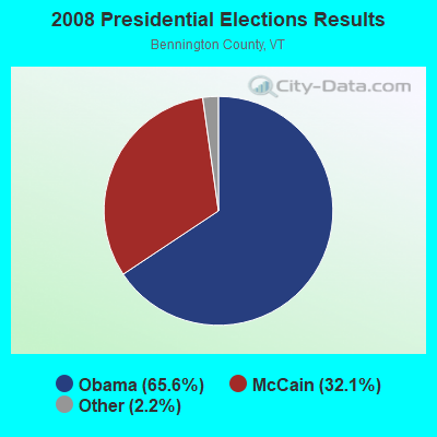
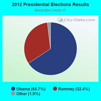
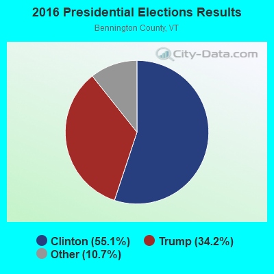
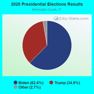
Graphs represent county-level data. Detailed 2008 Election Results
Religion statistics for Searsburg, VT (based on Bennington County data)

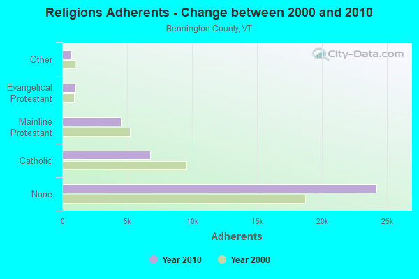
| Religion | Adherents | Congregations |
|---|---|---|
| Catholic | 6,742 | 8 |
| Mainline Protestant | 4,490 | 26 |
| Evangelical Protestant | 1,005 | 12 |
| Other | 693 | 5 |
| None | 24,195 | - |
Food Environment Statistics:
| This county: | 3.85 / 10,000 pop. |
| Vermont: | 3.84 / 10,000 pop. |
| Bennington County: | 3.30 / 10,000 pop. |
| Vermont: | 1.95 / 10,000 pop. |
| Here: | 5.77 / 10,000 pop. |
| Vermont: | 6.40 / 10,000 pop. |
| This county: | 16.48 / 10,000 pop. |
| Vermont: | 11.52 / 10,000 pop. |
| Bennington County: | 8.4% |
| Vermont: | 6.8% |
| This county: | 22.9% |
| Vermont: | 22.3% |
| Bennington County: | 11.6% |
| Vermont: | 13.3% |
Strongest AM radio stations in Searsburg:
- WNNZ (640 AM; 50 kW; WESTFIELD, MA; Owner: CLEAR CHANNEL BROADCASTING LICENSES, INC.)
- WGY (810 AM; 50 kW; SCHENECTADY, NY; Owner: CLEAR CHANNEL BROADCASTING LICENSES, INC.)
- WPTR (1540 AM; 50 kW; ALBANY, NY; Owner: KIMTRON, INC.)
- WCRN (830 AM; 50 kW; WORCESTER, MA; Owner: CARTER BROADCASTING CORPORATION)
- WIZZ (1520 AM; daytime; 10 kW; GREENFIELD, MA; Owner: P. & M. RADIO, LLC)
- WRKO (680 AM; 50 kW; BOSTON, MA; Owner: ENTERCOM BOSTON LICENSE, LLC)
- WVNE (760 AM; daytime; 25 kW; LEICESTER, MA; Owner: BLOUNT MASSCOM, INC.)
- WTIC (1080 AM; 50 kW; HARTFORD, CT; Owner: INFINITY RADIO OPERATIONS INC.)
- WEEI (850 AM; 50 kW; BOSTON, MA; Owner: ENTERCOM BOSTON LICENSE, LLC)
- WALE (990 AM; 50 kW; GREENVILLE, RI; Owner: NORTH AMERICAN BROADCASTING CO., INC.)
- WKOX (1200 AM; 50 kW; FRAMINGHAM, MA; Owner: CAPSTAR TX LIMITED PARTNERSHIP)
- WBIX (1060 AM; 40 kW; NATICK, MA; Owner: LANGER BROADCASTING CORPORATION)
- WBTN (1370 AM; 1 kW; BENNINGTON, VT; Owner: SOUTHERN VERMONT COLLEGE)
Strongest FM radio stations in Searsburg:
- WVAY (100.7 FM; WILMINGTON, VT; Owner: GREAT NORTHERN RADIO, L.L.C.)
- WEQX (102.7 FM; MANCHESTER, VT; Owner: NORTHSHIRE COMMUNICATIONS, INC.)
- WJAN (95.1 FM; SUNDERLAND, VT; Owner: 6 JOHNSON ROAD LICENSES, INC.)
- WAMC-FM (90.3 FM; ALBANY, NY; Owner: WAMC)
- WRSY (101.5 FM; MARLBORO, VT; Owner: GREAT NORTHERN RADIO, L.L.C.)
- WZEC (97.5 FM; HOOSICK FALLS, NY; Owner: GREAT NORTHERN RADIO, LLC)
- WKVT-FM (92.7 FM; BRATTLEBORO, VT; Owner: SAGA COMMUNICATIONS OF NEW ENGLAND, LLC)
- WCMK (91.9 FM; PUTNEY, VT; Owner: CHRISTIAN MINISTRIES INC)
- WMNB (100.1 FM; NORTH ADAMS, MA; Owner: BERKSHIRE BROADCASTING CO., INC.)
- WJJR (98.1 FM; RUTLAND, VT; Owner: 6 JOHNSON ROAD LICENSES, INC.)
- WZRT (97.1 FM; RUTLAND, VT; Owner: CAPSTAR TX LIMITED PARTNERSHIP)
- WEBK (105.3 FM; KILLINGTON, VT; Owner: 6 JOHNSON ROAD LICENSES, INC.)
- WVPR (89.5 FM; WINDSOR, VT; Owner: VERMONT PUBLIC RADIO)
- WHDQ (106.1 FM; CLAREMONT, NH; Owner: GREAT NORTHERN RADIO, L.L.C.)
- WPVQ (95.3 FM; GREENFIELD, MA; Owner: GREAT NORTHERN RADIO, L.L.C.)
- WGLV (91.7 FM; WOODSTOCK, VT; Owner: CHRISTIAN MINISTRIES INC)
- WHDQ-FM1 (106.1 FM; RUTLAND, VT; Owner: GREAT NORTHERN RADIO, L.L.C.)
- WNGN (91.9 FM; ARGYLE, NY; Owner: NORTHEAST GOSPEL BROADCASTING INC)
- WKNE (103.7 FM; KEENE, NH; Owner: SAGA COMMUNICATIONS OF NEW ENGLAND, LLC)
- WEVN (90.7 FM; KEENE, NH; Owner: NEW HAMPSHIRE PUBLIC RADIO, INC.)
TV broadcast stations around Searsburg:
- WCDC-TV (Channel 19; ADAMS, MA; Owner: YOUNG BROADCASTING OF ALBANY, INC.)
Searsburg fatal accident list:
Jul 2, 2010 04:04 PM, Sr-9, Lat: 42.894506, Lon: -72.994642, Vehicles: 2, Persons: 3, Fatalities: 1
Jul 31, 1998 04:55 PM, Sr-Vt9, Vehicles: 2, Persons: 4, Fatalities: 1
Jul 5, 1992 12:50 AM, Vt 9, Vehicles: 2, Persons: 3, Fatalities: 1
- National Bridge Inventory (NBI) Statistics
- 7Number of bridges
- 95ft / 28.7mTotal length
- $489,000Total costs
- 36,540Total average daily traffic
- 3,164Total average daily truck traffic
- 38,367Total future (year 2028) average daily traffic
FCC Registered Antenna Towers:
5- Michael J Umano, Off Sleepy Hollow Road (Lat: 42.885722 Lon: -72.953194), Type: 42.6, Structure height: 50003 m, Overall height: 42.6 m, Registrant: Industrial Tower And Wireless, LLC, Kevin.Delaney@itwllc.Com, , Marsh-feild, Phone: (781) 319-1011
- Michael J Umano, Off Sleepy Hollow Road (Lat: 42.885722 Lon: -72.953194), Type: 42.6, Structure height: 50003 m, Overall height: 42.6 m, Licensee ID: L, Registrant: Industrial Tower And Wireless, LLC, Kevin.Delaney@itwllc.Com, , Marsh-feild, Phone: (781) 319-1011
- Michael J Umano, Off Sleepy Hollow Road (Lat: 42.885722 Lon: -72.953194), Type: 42.6, Structure height: 50003 m, Overall height: 42.6 m, Registrant: Industrial Tower And Wireless, LLC, Kevin.Delaney@itwllc.Com, , Marsh-feild, Phone: (781) 319-1011
- Michael J Umano, 62 Sleepy Hollow Road (Lat: 42.885722 Lon: -72.953194), Type: 42.6, Structure height: 50003 m, Overall height: 42.6 m, Registrant: Industrial Tower And Wireless, LLC, Kevin.Delaney@itwllc.Com, , Marsh-feild, Phone: (781) 319-1011
- Michael J Umano, 62 Sleepy Hollow Road (Lat: 42.885722 Lon: -72.953194), Type: 42.6, Structure height: 50003 m, Overall height: 42.6 m, Registrant: Industrial Tower And Wireless, LLC, Kevin.Delaney@itwllc.Com, , Marsh-feild, Phone: (781) 319-1011
FCC Registered Private Land Mobile Towers:
1- 1.25 Mi Sw (Lat: 42.879722 Lon: -72.990278), Type: Tower, Structure height: 23.7 m, Call Sign: WQGX512,
Assigned Frequencies: 152.480 MHz, Grant Date: 04/11/2017, Expiration Date: 05/15/2027, Certifier: Kathy M Paskevich, Registrant: Jkl Communications LLC, 142 Avenue C, Williston, VT 05495, Phone: (802) 860-0000, Fax: (802) 860-5037, Email:
FCC Registered Broadcast Land Mobile Towers:
6- Searsburg Hydroelectric Station (Lat: 42.870361 Lon: -72.934000), Type: Pole, Structure height: 17 m, Call Sign: KWD914,
Assigned Frequencies: 154.456 MHz, 154.478 MHz, 173.337 MHz, Grant Date: 09/23/1997, Expiration Date: 09/23/2002, Cancellation Date: 01/12/2003, Certifier: Melissa Pusch, Registrant: Wiley Rein & Fielding LLP, 1776 K Street, N.W., Washington, DC 20006, Phone: (202) 719-7235, Fax: (202) 719-7049, Email:
- Searsburg Pipeline At Bond Brook And Vermont State Highway Route 9 (Lat: 42.881389 Lon: -72.950528), Type: Pipe, Structure height: 4.8 m, Overall height: 10 m, Call Sign: WPRA243,
Assigned Frequencies: 153.305 MHz, 151.970 MHz, Grant Date: 05/12/2015, Expiration Date: 05/31/2025, Certifier: Daniel R Revers, Registrant: Great River Hydro, LLC, 69 Milk Street, Suite 306, Westborough, MA 01581, Phone: (508) 614-0734, Email:
- Lat: 42.888333 Lon: -72.976389, Call Sign: WQZN443, Licensee ID: L01616084,
Assigned Frequencies: 456.437 MHz, 456.537 MHz, 456.637 MHz, 467.237 MHz, 467.287 MHz, 467.337 MHz, 467.387 MHz, 467.437 MHz, Grant Date: 06/16/2017, Expiration Date: 06/16/2027, Certifier: Brenda Pence, Registrant: Siemens Gamesa Renewable Energy, Inc.
- Lat: 42.888000 Lon: -72.976333, Call Sign: WRAC882,
Assigned Frequencies: 451.287 MHz, 452.137 MHz, 452.187 MHz, 457.137 MHz, 457.187 MHz, Grant Date: 10/12/2017, Expiration Date: 10/12/2027, Certifier: Mark Perry, Registrant: Radio Licensing Services, 4700 Se International Way, Milwaukie, OR 97269, Phone: (503) 659-1240, Fax: (503) 794-3759, Email:
- Deerfield Wind Turbine W1 (Lat: 42.884917 Lon: -72.985611), Type: Upole, Structure height: 130.5 m, Call Sign: WRAF768,
Assigned Frequencies: 9360.00 MHz, Grant Date: 11/03/2017, Expiration Date: 11/03/2027, Certifier: Mark Perryman, Registrant: Radio Licensing Services, 4700 Se International Way, Milwaukie, OR 97269, Phone: (503) 659-1240, Fax: (503) 794-3759, Email:
- Searsburg Pipeline At Bond Brook And Vermont State Highway Route 9 (Lat: 42.881389 Lon: -72.950528), Type: Pipe, Structure height: 4.8 m, Overall height: 10 m, Call Sign: WRDQ730,
Assigned Frequencies: 153.305 MHz, Grant Date: 06/28/2019, Expiration Date: 12/25/2019, Cancellation Date: 02/29/2020, Certifier: Erin A Odea, Registrant: Great River Hydro, LLC, 112 Turnpike Road, Suite 202, Westborough, MA 01581, Phone: (413) 773-6702, Email:
FCC Registered Amateur Radio Licenses:
1- Call Sign: KB1BRI, Licensee ID: L00624711, Grant Date: 05/15/1995, Expiration Date: 05/15/2005, Cancellation Date: 04/30/2004, Registrant: Southern Vermont Amateur Radio Club, Hcr 65 Box 10, Searsburg, VT 05363

- 67.6%Fuel oil, kerosene, etc.
- 23.5%Wood
- 8.8%Bottled, tank, or LP gas

- 71.4%Wood
- 28.6%Fuel oil, kerosene, etc.
Searsburg compared to Vermont state average:
- Median household income significantly below state average.
- Unemployed percentage below state average.
- Black race population percentage significantly below state average.
- Hispanic race population percentage below state average.
- Foreign-born population percentage significantly below state average.
- Renting percentage below state average.
- Length of stay since moving in significantly above state average.
- Number of rooms per house significantly below state average.
- House age significantly below state average.
- Number of college students significantly below state average.
- Percentage of population with a bachelor's degree or higher significantly below state average.