Waltham, Vermont
Submit your own pictures of this town and show them to the world
- OSM Map
- Google Map
- MSN Map
Population change since 2000: +1.5%
 |
| Males: 240 | |
| Females: 246 |
| Median resident age: | 48.6 years |
| Vermont median age: | 45.8 years |
Zip codes: 05491.
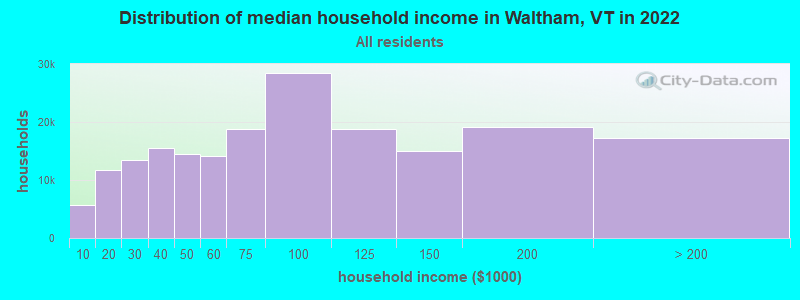
| Waltham: | $92,304 |
| VT: | $73,991 |
Estimated per capita income in 2022: $47,298 (it was $21,567 in 2000)
Waltham town income, earnings, and wages data
Estimated median house or condo value in 2022: $399,926 (it was $133,500 in 2000)
| Waltham: | $399,926 |
| VT: | $304,700 |
Mean prices in 2022: all housing units: $400,302; detached houses: $427,258; townhouses or other attached units: $389,241; in 2-unit structures: $373,341; in 3-to-4-unit structures: $633,103; in 5-or-more-unit structures: $292,995; mobile homes: $101,709
Detailed information about poverty and poor residents in Waltham, VT
Compare current foreclosures near Waltham, VT:
| Photo | Address | Area | Beds / Baths | Price | Details |
|---|---|---|---|---|---|

|
#1
Creek Rd
Crown Point, NY 12928
|
1,640 sq. feet
|
2 baths 3 beds |
$42,000
|
show details |

|
#2
Plank Rd
Mineville, NY 12956
|
- sq. feet
|
2 baths 6 beds |
show details | |

|
#3
Middlebrook Rd
Ferrisburg, VT 05456
|
2,346 sq. feet
|
2 baths 3 beds |
show details | |

|
#4
Witherbee Rd
Witherbee, NY 12998
|
975 sq. feet
|
1 baths 2 beds |
show details | |

|
#5
Ferry Rd
Crown Point, NY 12928
|
960 sq. feet
|
1 baths 3 beds |
show details | |

|
#6
Windy Hill Rd
Moriah, NY 12960
|
1,162 sq. feet
|
1 baths 3 beds |
show details | |

|
#7
Champlain Dr
Mineville, NY 12956
|
2,206 sq. feet
|
2 baths 3 beds |
show details | |

|
#8
Ross Way
Essex, NY 12936
|
- sq. feet
|
- baths - beds |
show details | |

|
#9
Armory Ln Apt 201
Vergennes, VT 05491
|
- sq. feet
|
- baths - beds |
show details | |

|
#10
Dynamite Ln
Mineville, NY 12956
|
- sq. feet
|
- baths - beds |
show details |
| Photo | Address | Area | Beds / Baths | Price | Details |
|---|---|---|---|---|---|

|
#11
Pine St # 4
Bristol, VT 05443
|
- sq. feet
|
- baths - beds |
show details | |

|
#12
N Meadow Dr
Bristol, VT 05443
|
- sq. feet
|
- baths - beds |
show details | |

|
#13
Jourdan St
Hinesburg, VT 05461
|
- sq. feet
|
- baths - beds |
show details | |

|
#14
Broad St
Port Henry, NY 12974
|
- sq. feet
|
- baths - beds |
show details | |

|
#15
Hardscrabble Rd
Bristol, VT 05443
|
- sq. feet
|
- baths - beds |
show details | |

|
#16
Lazy Brook Dr
Starksboro, VT 05487
|
- sq. feet
|
- baths - beds |
show details | |

|
#17
Henrys Way
Ferrisburg, VT 05456
|
- sq. feet
|
- baths - beds |
show details | |

|
#18
S Maple St
Vergennes, VT 05491
|
- sq. feet
|
- baths - beds |
show details | |

|
Check over 1 million property listings on Foreclosure.com!
|
browse all offers | |||

- 47497.5%White alone
- 51.0%Hispanic
- 30.6%American Indian alone
- 20.4%Black alone
- 20.4%Asian alone
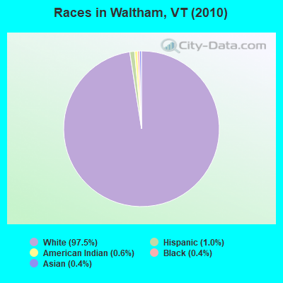
Races in Waltham detailed stats: ancestries, foreign born residents, place of birth
 Recent articles from our blog. Our writers, many of them Ph.D. graduates or candidates, create easy-to-read articles on a wide variety of topics.

Ancestries: English (20.9%), United States (13.2%), French (12.3%), Irish (11.9%), French Canadian (9.0%), Italian (7.9%).
Current Local Time: EST time zone
Land area: 8.72 square miles.
Population density: 56 people per square mile (very low).
31 residents are foreign born (3.1% Asia, 2.3% Europe, 1.0% North America).
| This town: | 6.5% |
| Vermont: | 3.8% |
| Waltham town: | 1.7% ($2,310) |
| Vermont: | 2.0% ($2,196) |
Nearest city with pop. 50,000+: Schenectady, NY  (99.0 miles , pop. 61,821).
Nearest city with pop. 200,000+: Boston, MA (166.1 miles , pop. 589,141).
Nearest city with pop. 1,000,000+: Bronx, NY (230.4 miles , pop. 1,332,650).
Nearest cities:
), ), ), ), Latitude: 44.14 N, Longitude: 73.24 W
Area code commonly used in this area: 802
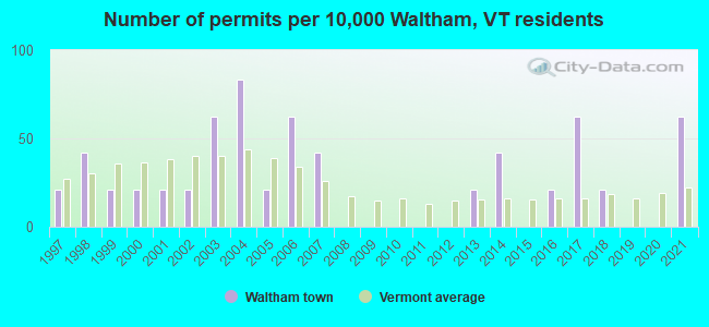
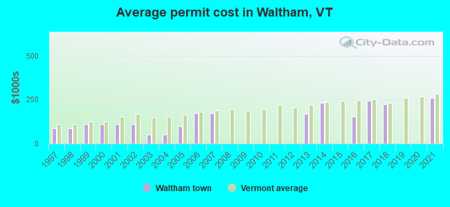
Single-family new house construction building permits:
- 2021: 3 buildings, average cost: $259,200
- 2018: 1 building, cost: $225,000
- 2017: 3 buildings, average cost: $241,700
- 2016: 1 building, cost: $155,000
- 2014: 2 buildings, average cost: $232,500
- 2013: 1 building, cost: $168,000
- 2007: 2 buildings, average cost: $171,000
- 2006: 3 buildings, average cost: $171,000
- 2005: 1 building, cost: $100,000
- 2004: 4 buildings, average cost: $50,000
- 2003: 3 buildings, average cost: $50,000
- 2002: 1 building, cost: $109,200
- 2001: 1 building, cost: $109,200
- 2000: 1 building, cost: $109,200
- 1999: 1 building, cost: $109,200
- 1998: 2 buildings, average cost: $87,400
- 1997: 1 building, cost: $87,400
| Here: | 1.0% |
| Vermont: | 2.0% |
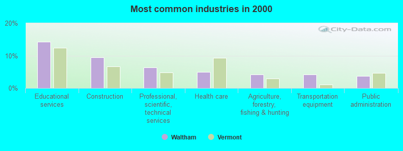
- Educational services (14.3%)
- Construction (9.4%)
- Professional, scientific, technical services (6.4%)
- Health care (4.9%)
- Agriculture, forestry, fishing & hunting (4.2%)
- Transportation equipment (4.2%)
- Public administration (3.8%)
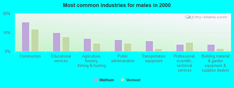
- Construction (15.5%)
- Educational services (9.9%)
- Agriculture, forestry, fishing & hunting (6.8%)
- Public administration (6.2%)
- Transportation equipment (5.6%)
- Professional, scientific, technical services (3.7%)
- Building material & garden equipment & supplies dealers (3.7%)
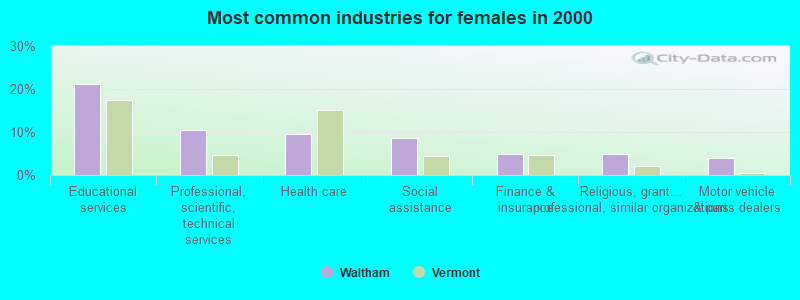
- Educational services (21.2%)
- Professional, scientific, technical services (10.6%)
- Health care (9.6%)
- Social assistance (8.7%)
- Finance & insurance (4.8%)
- Religious, grantmaking, civic, professional, similar organizations (4.8%)
- Motor vehicle & parts dealers (3.8%)
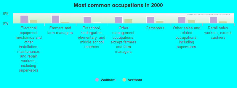
- Electrical equipment mechanics and other installation, maintenance, and repair workers, including supervisors (4.9%)
- Farmers and farm managers (4.9%)
- Preschool, kindergarten, elementary, and middle school teachers (4.2%)
- Other management occupations, except farmers and farm managers (4.2%)
- Carpenters (4.2%)
- Other sales and related occupations, including supervisors (4.2%)
- Retail sales workers, except cashiers (3.8%)
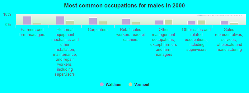
- Farmers and farm managers (8.1%)
- Electrical equipment mechanics and other installation, maintenance, and repair workers, including supervisors (8.1%)
- Carpenters (6.8%)
- Retail sales workers, except cashiers (6.2%)
- Other management occupations, except farmers and farm managers (4.3%)
- Other sales and related occupations, including supervisors (3.7%)
- Sales representatives, services, wholesale and manufacturing (3.7%)
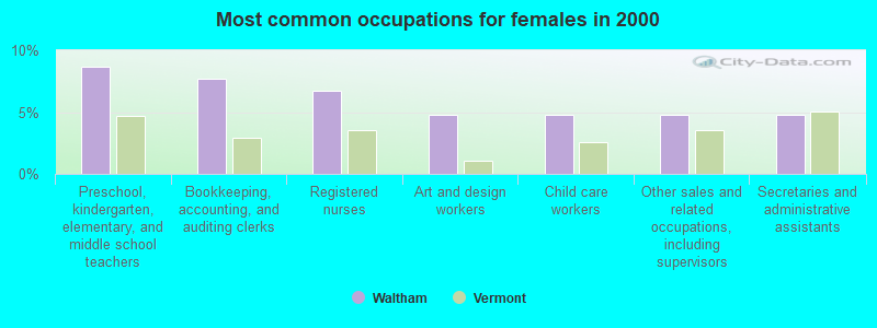
- Preschool, kindergarten, elementary, and middle school teachers (8.7%)
- Bookkeeping, accounting, and auditing clerks (7.7%)
- Registered nurses (6.7%)
- Art and design workers (4.8%)
- Child care workers (4.8%)
- Other sales and related occupations, including supervisors (4.8%)
- Secretaries and administrative assistants (4.8%)
Average climate in Waltham, Vermont
Based on data reported by over 4,000 weather stations


(lower is better)
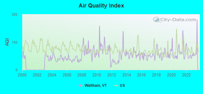
Air Quality Index (AQI) level in 2022 was 55.1. This is better than average.
| City: | 55.1 |
| U.S.: | 72.6 |
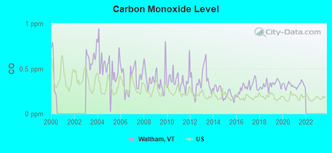
Carbon Monoxide (CO) [ppm] level in 2021 was 0.317. This is worse than average. Closest monitor was 23.0 miles away from the city center.
| City: | 0.317 |
| U.S.: | 0.251 |
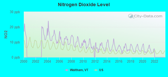
Nitrogen Dioxide (NO2) [ppb] level in 2021 was 4.81. This is about average. Closest monitor was 23.0 miles away from the city center.
| City: | 4.81 |
| U.S.: | 5.11 |
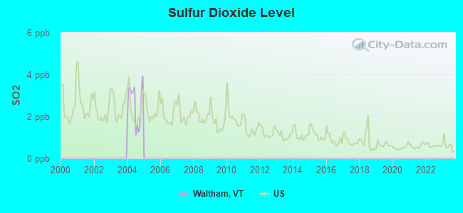
Sulfur Dioxide (SO2) [ppb] level in 2004 was 2.59. This is significantly worse than average. Closest monitor was 12.4 miles away from the city center.
| City: | 2.59 |
| U.S.: | 1.51 |

Particulate Matter (PM2.5) [µg/m3] level in 2022 was 6.79. This is about average. Closest monitor was 16.8 miles away from the city center.
| City: | 6.79 |
| U.S.: | 8.11 |
Earthquake activity:
Waltham-area historical earthquake activity is significantly above Vermont state average. It is 70% smaller than the overall U.S. average.On 4/20/2002 at 10:50:47, a magnitude 5.3 (5.3 ML, Depth: 3.0 mi, Class: Moderate, Intensity: VI - VII) earthquake occurred 34.2 miles away from the city center
On 4/20/2002 at 10:50:47, a magnitude 5.2 (5.2 MB, 4.2 MS, 5.2 MW, 5.0 MW) earthquake occurred 33.7 miles away from Waltham center
On 10/7/1983 at 10:18:46, a magnitude 5.3 (5.1 MB, 5.3 LG, 5.1 ML) earthquake occurred 56.6 miles away from the city center
On 1/19/1982 at 00:14:42, a magnitude 4.7 (4.5 MB, 4.7 MD, 4.5 LG, Class: Light, Intensity: IV - V) earthquake occurred 93.0 miles away from the city center
On 10/16/2012 at 23:12:25, a magnitude 4.7 (4.7 ML, Depth: 10.0 mi) earthquake occurred 134.0 miles away from the city center
On 4/20/2000 at 08:46:55, a magnitude 3.8 (3.8 ML, Depth: 3.1 mi, Class: Light, Intensity: II - III) earthquake occurred 52.6 miles away from Waltham center
Magnitude types: regional Lg-wave magnitude (LG), body-wave magnitude (MB), duration magnitude (MD), local magnitude (ML), surface-wave magnitude (MS), moment magnitude (MW)
Natural disasters:
The number of natural disasters in Addison County (23) is greater than the US average (15).Major Disasters (Presidential) Declared: 16
Emergencies Declared: 3
Causes of natural disasters: Floods: 16, Storms: 15, Drought: 1, Heavy Rain: 1, Hurricane: 1, Ice Storm: 1, Landslide: 1, Snow: 1, Snowstorm: 1, Tornado: 1, Tropical Storm: 1, Wind: 1, Winter Storm: 1, Other: 1 (Note: some incidents may be assigned to more than one category).
Hospitals and medical centers near Waltham:
- CLARK NURSING HOME (Nursing Home, about 2 miles away; VERGENNES, VT)
- HELEN PORTER HEALTHCARE AND REHAB (Nursing Home, about 11 miles away; MIDDLEBURY, VT)
- PORTER HOSPITAL, INC Critical Access Hospitals (about 11 miles away; MIDDLEBURY, VT)
- WAKE ROBIN-LINDEN NURSING HOME (Nursing Home, about 15 miles away; SHELBURNE, VT)
Amtrak stations near Waltham:
- 12 miles: WESTPORT (HWY. 9 N. & D&H RAILROAD TRACKS) . Services: enclosed waiting area, public restrooms, public payphones, free short-term parking, free long-term parking.
- 14 miles: PORT HENRY (RTE. 9 NORTH & RTE. 22) . Services: enclosed waiting area, public restrooms, public payphones, free short-term parking, free long-term parking, call for car rental service, call for taxi service.
Colleges/universities with over 2000 students nearest to Waltham:
- Middlebury College (about 10 miles; Middlebury, VT; Full-time enrollment: 3,077)
- Champlain College (about 23 miles; Burlington, VT; FT enrollment: 2,623)
- University of Vermont (about 24 miles; Burlington, VT; FT enrollment: 11,566)
- Community College of Vermont (about 25 miles; Winooski, VT; FT enrollment: 3,394)
- Saint Michael's College (about 25 miles; Colchester, VT; FT enrollment: 2,336)
- Norwich University (about 29 miles; Northfield, VT; FT enrollment: 4,221)
- Castleton State College (about 38 miles; Castleton, VT; FT enrollment: 2,079)
Points of interest:
Cemeteries: Chipman Cemetery (1), Ward Cemetery (2), Sunset View Cemetery (3). Display/hide their locations on the map
| This town: | 2.4 people |
| Vermont: | 2.3 people |
| This town: | 69.6% |
| Whole state: | 62.5% |
| This town: | 5.4% |
| Whole state: | 9.2% |
Likely homosexual households (counted as self-reported same-sex unmarried-partner households)
- Lesbian couples: 1.0% of all households
- Gay men: 0.0% of all households
| This town: | 4.2% |
| Whole state: | 9.4% |
| This town: | 3.2% |
| Whole state: | 3.6% |
For population 15 years and over in Waltham:
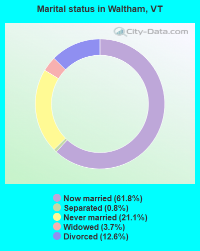
- Never married: 21.1%
- Now married: 61.8%
- Separated: 0.8%
- Widowed: 3.7%
- Divorced: 12.6%
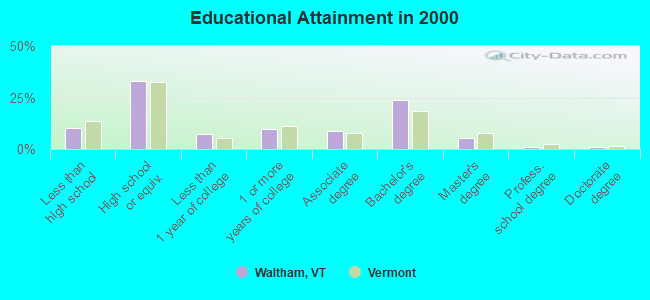
For population 25 years and over in Waltham:
- High school or higher: 89.7%
- Bachelor's degree or higher: 31.1%
- Graduate or professional degree: 7.6%
- Mean travel time to work (commute): 23.1 minutes
| Here: | 10.3 |
| Vermont average: | 11.7 |
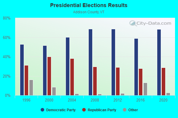
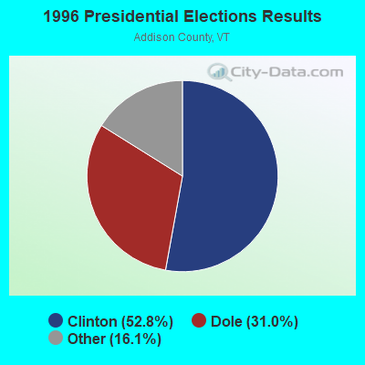

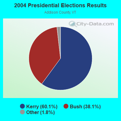
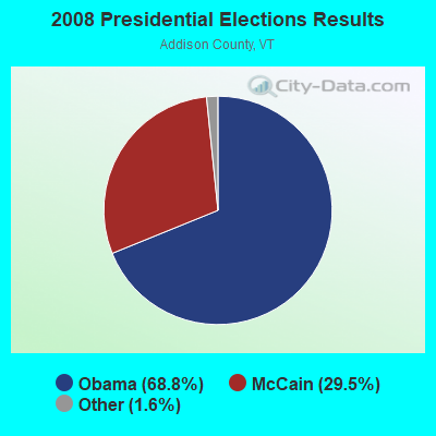
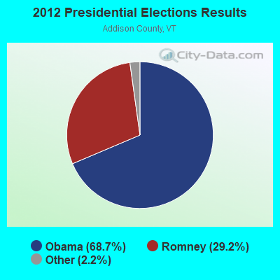
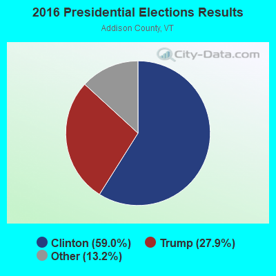
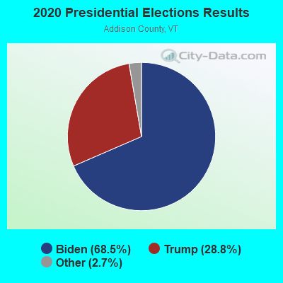
Graphs represent county-level data. Detailed 2008 Election Results
Religion statistics for Waltham, VT (based on Addison County data)
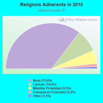
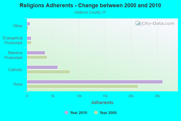
| Religion | Adherents | Congregations |
|---|---|---|
| Catholic | 5,892 | 6 |
| Mainline Protestant | 3,491 | 27 |
| Evangelical Protestant | 801 | 13 |
| Other | 560 | 6 |
| None | 26,077 | - |
Food Environment Statistics:
| Addison County: | 4.64 / 10,000 pop. |
| Vermont: | 3.84 / 10,000 pop. |
| Addison County: | 1.36 / 10,000 pop. |
| State: | 1.95 / 10,000 pop. |
| Addison County: | 6.55 / 10,000 pop. |
| Vermont: | 6.40 / 10,000 pop. |
| Here: | 8.45 / 10,000 pop. |
| State: | 11.52 / 10,000 pop. |
| Addison County: | 5.8% |
| State: | 6.8% |
| Addison County: | 20.9% |
| Vermont: | 22.3% |
| This county: | 9.1% |
| State: | 13.3% |
Strongest AM radio stations in Waltham:
- WCHP (760 AM; 35 kW; CHAMPLAIN, NY; Owner: CHAMPLAIN RADIO, INC.)
- WDEV (550 AM; 5 kW; WATERBURY, VT; Owner: RADIO VERMONT, INC.)
- WVMT (620 AM; 5 kW; BURLINGTON, VT; Owner: SISON BROADCASTING, INC.)
- WICY (1490 AM; 50 kW; MALONE, NY; Owner: CARTIER COMMUNICATIONS INC.)
- WVAA (1390 AM; 5 kW; BURLINGTON, VT; Owner: RADIO VERMONT, KDR, LLC)
- WFAD (1490 AM; 1 kW; MIDDLEBURY, VT; Owner: ADDISON BROADCASTING COMPANY, INC.)
- WGY (810 AM; 50 kW; SCHENECTADY, NY; Owner: CLEAR CHANNEL BROADCASTING LICENSES, INC.)
- WEAV (960 AM; 5 kW; PLATTSBURGH, NY; Owner: CLEAR CHANNEL BROADCASTING LICENSES, INC.)
- WTWK (1070 AM; daytime; 5 kW; PLATTSBURGH, NY; Owner: CHAMPLAIN COMMUNICATIONS CORPORATION)
- WNNZ (640 AM; 50 kW; WESTFIELD, MA; Owner: CLEAR CHANNEL BROADCASTING LICENSES, INC.)
- WIRD (920 AM; 5 kW; LAKE PLACID, NY; Owner: RADIO LAKE PLACID INC)
- WPTR (1540 AM; 50 kW; ALBANY, NY; Owner: KIMTRON, INC.)
- WRKO (680 AM; 50 kW; BOSTON, MA; Owner: ENTERCOM BOSTON LICENSE, LLC)
Strongest FM radio stations in Waltham:
- WDEV-FM (96.1 FM; WARREN, VT; Owner: RADIO VERMONT, INC.)
- WWFY (100.9 FM; BERLIN, VT; Owner: VOX ALLEGANY, LLC)
- WCVT (101.7 FM; STOWE, VT; Owner: RADIO VERMONT CLASSICS, L.L.C.)
- WIZN (106.7 FM; VERGENNES, VT; Owner: BURLINGTON BROADCASTERS, INC.)
- WXZO (96.7 FM; WILLSBORO, NY; Owner: CAPSTAR TX LIMITED PARTNERSHIP)
- WVPS (107.9 FM; BURLINGTON, VT; Owner: VERMONT PUBLIC RADIO)
- WNCS (104.7 FM; MONTPELIER, VT; Owner: MONTPELIER BROADCASTING, INC.)
- WEZF (92.9 FM; BURLINGTON, VT; Owner: CAPSTAR TX LIMITED PARTNERSHIP)
- WLKC (103.3 FM; WATERBURY, VT; Owner: RADIO BROADCASTING SERVICES, INC.)
- WEBK (105.3 FM; KILLINGTON, VT; Owner: 6 JOHNSON ROAD LICENSES, INC.)
- WEXP (101.5 FM; BRANDON, VT; Owner: VOX VERMONT, L.L.C.)
- WJJR (98.1 FM; RUTLAND, VT; Owner: 6 JOHNSON ROAD LICENSES, INC.)
- WZRT (97.1 FM; RUTLAND, VT; Owner: CAPSTAR TX LIMITED PARTNERSHIP)
- WGLV (91.7 FM; WOODSTOCK, VT; Owner: CHRISTIAN MINISTRIES INC)
- WHDQ-FM1 (106.1 FM; RUTLAND, VT; Owner: GREAT NORTHERN RADIO, L.L.C.)
- WGLY-FM (91.5 FM; BOLTON, VT; Owner: CHRISTIAN MINISTRIES, INC.)
- WJEN (94.5 FM; RUTLAND, VT; Owner: 6 JOHNSON ROAD LICENSES, INC.)
- WCLX (102.5 FM; WESTPORT, NY; Owner: WESTPORT BROADCASTING)
- WRMC-FM (91.1 FM; MIDDLEBURY, VT; Owner: THE PRESIDENT AND FELLOWS OF MIDDLEBURY COLLEGE)
- WCEL (91.9 FM; PLATTSBURGH, NY; Owner: WAMC)
TV broadcast stations around Waltham:
- W19BR (Channel 19; MONKTON, VT; Owner: PLATTSBURGH PARTNERS)
- W25BT (Channel 25; MONKTON, VT; Owner: MOUNTAIN LAKES PUB.TELECOMM.COUNCIL)
- W62BY (Channel 62; MONKTON, VT; Owner: VERMONT WIRELESS COOPERATIVE)
- W64BP (Channel 64; MONKTON, VT; Owner: VERMONT WIRELESS COOPERATIVE)
- W66BX (Channel 66; MONKTON, VT; Owner: VERMONT WIRELESS COOPERATIVE)
- W68CK (Channel 68; MONKTON, VT; Owner: VERMONT WIRELESS COOPERATIVE)
- WPTZ (Channel 5; NORTH POLE, NY; Owner: HEARST-ARGYLE STATIONS, INC.)
- W16AL (Channel 16; BURLINGTON, VT; Owner: TRINITY BROADCASTING NETWORK)
- W60AO (Channel 60; PORT HENRY, NY; Owner: MOUNTAIN LAKES PUB.TELECOMM.COUNCIL)
FCC Registered Amateur Radio Licenses:
7- Call Sign: KB2TBK, Licensee ID: L00580557, Grant Date: 12/16/2004, Expiration Date: 01/11/2015, Cancellation Date: 05/13/2005, Registrant: Paul J Mc Mahon, 1696 Maple St, Waltham, VT 05491-9439
- Call Sign: KE1AH, Previous Call Sign: KA1KCS, Licensee ID: L01145782, Grant Date: 04/12/2016, Expiration Date: 05/02/2026, Registrant: Frederick L Lichtenfels Ii, 783 Maple Street, Waltham, VT 05491
- Call Sign: N1VWD, Licensee ID: L00133575, Grant Date: 07/09/2015, Expiration Date: 09/21/2025, Certifier: Bradford B Mc Kirryher, Registrant: Bradford B Mc Kirryher, 2317 Maple St, Waltham, VT 05491-9419
- Call Sign: N1YQB, Licensee ID: L00133592, Grant Date: 01/04/2017, Expiration Date: 02/26/2027, Certifier: Chris B Mc Kirryher, Registrant: Chris B Mc Kirryher, 2317 Maple St, Waltham, VT 05491-9419
- Call Sign: N1YSB, Licensee ID: L00133587, Grant Date: 01/05/2017, Expiration Date: 03/12/2027, Certifier: Judith A Mc Kirryher, Registrant: Judith A Mc Kirryher, 2317 Maple St, Waltham, VT 05491-9419
- Call Sign: N1YVZ, Licensee ID: L00133602, Grant Date: 01/12/2017, Expiration Date: 03/31/2027, Certifier: Bradford B Mc Kirryher Iii, Registrant: Bradford B Mc Kirryher Iii, 2317 Maple St, Waltham, VT 05491-9419
- Call Sign: K1PJM, Previous Call Sign: KB2TBK, Licensee ID: L00580557, Grant Date: 09/01/2015, Expiration Date: 09/01/2025, Certifier: Paul J Mc Mahon, Registrant: Paul J Mc Mahon, 1696 Maple St, Waltham, VT 05491-9439
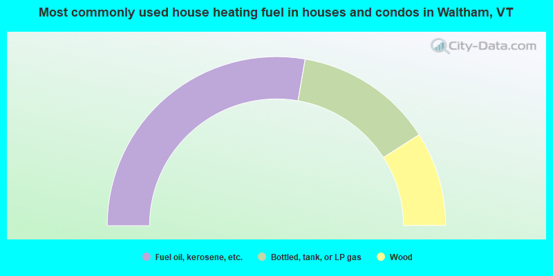
- 55.5%Fuel oil, kerosene, etc.
- 26.5%Bottled, tank, or LP gas
- 18.1%Wood
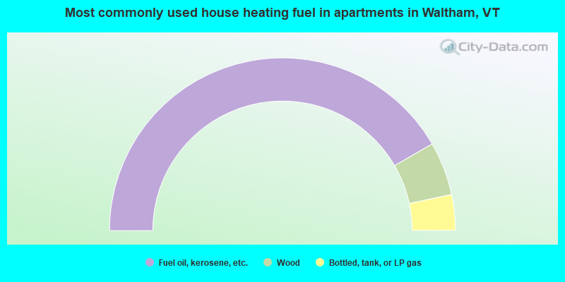
- 83.3%Fuel oil, kerosene, etc.
- 10.0%Wood
- 6.7%Bottled, tank, or LP gas
Waltham compared to Vermont state average:
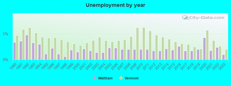
- Unemployed percentage significantly below state average.
- Black race population percentage below state average.
- Hispanic race population percentage below state average.
- Renting percentage below state average.
- Length of stay since moving in significantly above state average.
- Number of rooms per house significantly below state average.
- House age significantly below state average.
- Number of college students significantly below state average.

|
Total of 4 patent applications in 2008-2024.