Washington, Maine
Submit your own pictures of this town and show them to the world
- OSM Map
- General Map
- Google Map
- MSN Map
Population change since 2000: +13.5%
 |
| Males: 793 | |
| Females: 734 |
| Median resident age: | 43.9 years |
| Maine median age: | 43.0 years |
Zip codes: 04574.
| Washington: | $67,761 |
| ME: | $69,543 |
Estimated per capita income in 2022: $31,654 (it was $15,488 in 2000)
Washington town income, earnings, and wages data
Estimated median house or condo value in 2022: $255,092 (it was $90,800 in 2000)
| Washington: | $255,092 |
| ME: | $290,600 |
Detailed information about poverty and poor residents in Washington, ME
Compare current foreclosures near Washington, ME:
| Photo | Address | Area | Beds / Baths | Price | Details |
|---|---|---|---|---|---|

|
#1
Crommett Dr
South China, ME 04358
|
- sq. feet
|
1 baths 2 beds |
$94,900
|
show details |

|
#2
Rabbit Path Rd
Alna, ME 04535
|
- sq. feet
|
2 baths 3 beds |
show details | |

|
#3
Caswell Rd
Windsor, ME 04363
|
- sq. feet
|
- baths - beds |
show details | |

|
#4
Cape Hill Rd
Jefferson, ME 04348
|
- sq. feet
|
- baths - beds |
show details | |

|
#5
Lamson Rd
Augusta, ME 04330
|
- sq. feet
|
- baths - beds |
show details | |

|
#6
Cooper Rd
Morrill, ME 04952
|
- sq. feet
|
- baths - beds |
show details | |

|
#7
Washington Rd
Jefferson, ME 04348
|
- sq. feet
|
- baths - beds |
show details | |

|
#8
Barrett Hill Rd
Union, ME 04862
|
- sq. feet
|
- baths - beds |
show details | |

|
#9
S Union Rd
Union, ME 04862
|
- sq. feet
|
- baths - beds |
show details | |

|
#10
Genthner Rd
Waldoboro, ME 04572
|
- sq. feet
|
- baths - beds |
show details |
| Photo | Address | Area | Beds / Baths | Price | Details |
|---|---|---|---|---|---|

|
#11
Main St
Vassalboro, ME 04989
|
- sq. feet
|
- baths - beds |
show details | |

|
#12
Abbott Rd
Albion, ME 04910
|
- sq. feet
|
- baths - beds |
show details | |

|
#13
Beechwood St
Thomaston, ME 04861
|
- sq. feet
|
- baths - beds |
show details | |

|
Check over 1 million property listings on Foreclosure.com!
|
browse all offers | |||

- 1,47596.6%White alone
- 291.9%Two or more races
- 80.5%American Indian alone
- 60.4%Black alone
- 60.4%Hispanic
- 20.1%Asian alone
- 10.07%Other race alone
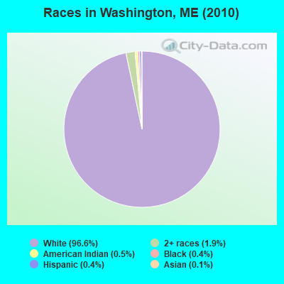
Races in Washington detailed stats: ancestries, foreign born residents, place of birth
According to our research of Maine and other state lists, there were 4 registered sex offenders living in Washington, Maine as of April 26, 2024.
The ratio of all residents to sex offenders in Washington is 382 to 1.
 Recent articles from our blog. Our writers, many of them Ph.D. graduates or candidates, create easy-to-read articles on a wide variety of topics.


 | From Washington to Maine (28 replies) |
| Siding Contractors that work in Washington county (8 replies) |
| Want Maine? Fill this out. (141 replies) |
| Moving advice. From Texas to Washington or Maine (17 replies) |
| Deciding between Maine and Washington (34 replies) |
| Moving to Maine on a budget (14 replies) |
Latest news from Washington, ME collected exclusively by city-data.com from local newspapers, TV, and radio stations
Washington, ME City Guides:
Ancestries: English (25.0%), Irish (11.2%), German (11.0%), United States (10.6%), French (8.0%), Scottish (5.7%).
Current Local Time: EST time zone
Incorporated on 02/27/1811
Elevation: 300 feet
Land area: 38.0 square miles.
Population density: 40 people per square mile (very low).
6 residents are foreign born
| This town: | 0.4% |
| Maine: | 2.9% |
| Washington town: | 0.9% ($816) |
| Maine: | 1.5% ($1,417) |
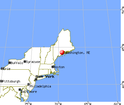
Nearest city with pop. 50,000+: Portland, ME  (60.8 miles , pop. 64,249).
Nearest city with pop. 200,000+: Boston, MA (159.9 miles , pop. 589,141).
Nearest city with pop. 1,000,000+: Bronx, NY (329.2 miles , pop. 1,332,650).
Nearest cities:
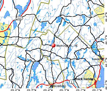
), ), ), ), Latitude: 44.27 N, Longitude: 69.39 W
Area code: 207

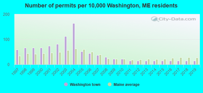
Single-family new house construction building permits:
- 2019: 2 buildings, average cost: $142,900
- 2018: 2 buildings, average cost: $142,900
- 2017: 2 buildings, average cost: $142,900
- 2016: 2 buildings, average cost: $142,900
- 2015: 2 buildings, average cost: $142,900
- 2014: 2 buildings, average cost: $142,900
- 2013: 2 buildings, average cost: $142,900
- 2012: 2 buildings, average cost: $142,900
- 2011: 2 buildings, average cost: $142,900
- 2010: 3 buildings, average cost: $142,900
- 2009: 3 buildings, average cost: $142,900
- 2008: 4 buildings, average cost: $142,900
- 2007: 5 buildings, average cost: $142,900
- 2006: 6 buildings, average cost: $142,900
- 2005: 7 buildings, average cost: $142,900
- 2004: 22 buildings, average cost: $130,000
- 2003: 15 buildings, average cost: $66,700
- 2002: 11 buildings, average cost: $78,200
- 2001: 10 buildings, average cost: $78,200
- 2000: 9 buildings, average cost: $78,200
- 1999: 9 buildings, average cost: $78,200
- 1998: 9 buildings, average cost: $78,200
- 1997: 8 buildings, average cost: $78,200

| Here: | 4.7% |
| Maine: | 3.4% |
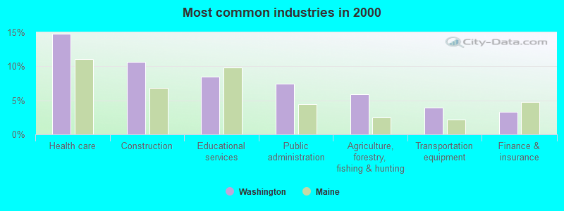
- Health care (14.7%)
- Construction (10.6%)
- Educational services (8.5%)
- Public administration (7.4%)
- Agriculture, forestry, fishing & hunting (5.9%)
- Transportation equipment (4.0%)
- Finance & insurance (3.3%)
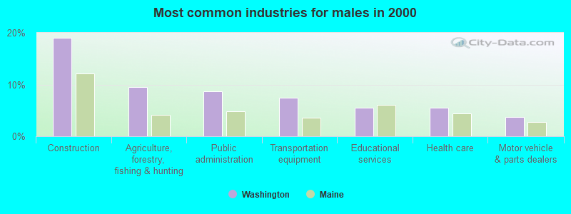
- Construction (19.1%)
- Agriculture, forestry, fishing & hunting (9.5%)
- Public administration (8.7%)
- Transportation equipment (7.5%)
- Educational services (5.5%)
- Health care (5.5%)
- Motor vehicle & parts dealers (3.8%)
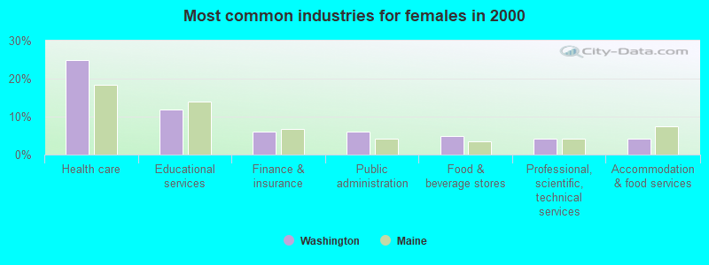
- Health care (25.0%)
- Educational services (11.9%)
- Finance & insurance (6.1%)
- Public administration (6.1%)
- Food & beverage stores (4.8%)
- Professional, scientific, technical services (4.2%)
- Accommodation & food services (4.2%)

- Other sales and related occupations, including supervisors (5.0%)
- Other management occupations, except farmers and farm managers (4.3%)
- Material recording, scheduling, dispatching, and distributing workers (4.3%)
- Carpenters (4.1%)
- Building and grounds cleaning and maintenance occupations (4.1%)
- Nursing, psychiatric, and home health aides (3.3%)
- Driver/sales workers and truck drivers (3.3%)
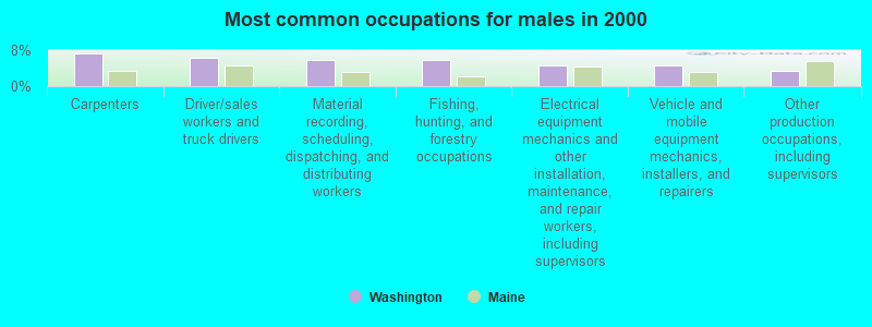
- Carpenters (7.2%)
- Driver/sales workers and truck drivers (6.4%)
- Material recording, scheduling, dispatching, and distributing workers (5.8%)
- Fishing, hunting, and forestry occupations (5.8%)
- Electrical equipment mechanics and other installation, maintenance, and repair workers, including supervisors (4.6%)
- Vehicle and mobile equipment mechanics, installers, and repairers (4.6%)
- Other production occupations, including supervisors (3.5%)
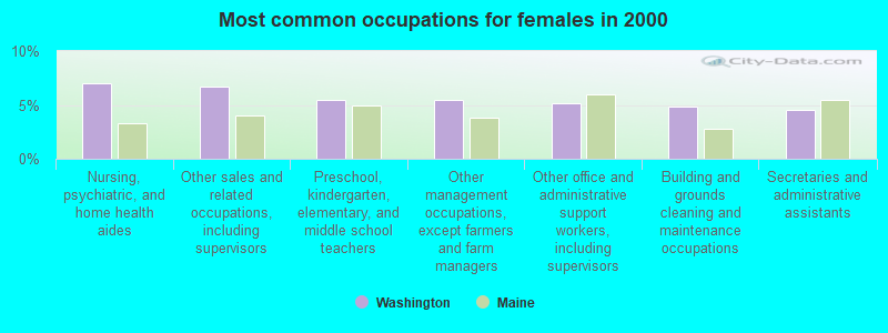
- Nursing, psychiatric, and home health aides (7.1%)
- Other sales and related occupations, including supervisors (6.7%)
- Preschool, kindergarten, elementary, and middle school teachers (5.4%)
- Other management occupations, except farmers and farm managers (5.4%)
- Other office and administrative support workers, including supervisors (5.1%)
- Building and grounds cleaning and maintenance occupations (4.8%)
- Secretaries and administrative assistants (4.5%)
Average climate in Washington, Maine
Based on data reported by over 4,000 weather stations


(lower is better)
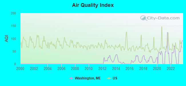
Air Quality Index (AQI) level in 2023 was 62.3. This is about average.
| City: | 62.3 |
| U.S.: | 72.6 |
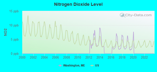
Nitrogen Dioxide (NO2) [ppb] level in 2019 was 2.80. This is significantly better than average. Closest monitor was 19.1 miles away from the city center.
| City: | 2.80 |
| U.S.: | 5.11 |

Sulfur Dioxide (SO2) [ppb] level in 2019 was 0.185. This is significantly better than average. Closest monitor was 16.8 miles away from the city center.
| City: | 0.185 |
| U.S.: | 1.515 |

Ozone [ppb] level in 2023 was 29.5. This is about average. Closest monitor was 19.1 miles away from the city center.
| City: | 29.5 |
| U.S.: | 33.3 |


Earthquake activity:
Washington-area historical earthquake activity is significantly above Maine state average. It is 78% smaller than the overall U.S. average.On 10/16/2012 at 23:12:25, a magnitude 4.7 (4.7 ML, Depth: 10.0 mi, Class: Light, Intensity: IV - V) earthquake occurred 78.7 miles away from Washington center
On 4/20/2002 at 10:50:47, a magnitude 5.3 (5.3 ML, Depth: 3.0 mi, Class: Moderate, Intensity: VI - VII) earthquake occurred 213.7 miles away from the city center
On 4/20/2002 at 10:50:47, a magnitude 5.2 (5.2 MB, 4.2 MS, 5.2 MW, 5.0 MW) earthquake occurred 214.7 miles away from the city center
On 1/19/1982 at 00:14:42, a magnitude 4.7 (4.5 MB, 4.7 MD, 4.5 LG) earthquake occurred 122.6 miles away from the city center
On 10/7/1983 at 10:18:46, a magnitude 5.3 (5.1 MB, 5.3 LG, 5.1 ML) earthquake occurred 247.1 miles away from the city center
On 2/26/1999 at 03:38:43, a magnitude 3.8 (3.8 LG, Depth: 2.0 mi, Class: Light, Intensity: II - III) earthquake occurred 15.8 miles away from Washington center
Magnitude types: regional Lg-wave magnitude (LG), body-wave magnitude (MB), duration magnitude (MD), local magnitude (ML), surface-wave magnitude (MS), moment magnitude (MW)
Natural disasters:
The number of natural disasters in Knox County (23) is greater than the US average (15).Major Disasters (Presidential) Declared: 18
Emergencies Declared: 4
Causes of natural disasters: Floods: 16, Storms: 12, Winter Storms: 4, Snows: 3, Hurricanes: 2, Blizzard: 1, Heavy Rain: 1, Ice Storm: 1, Landslide: 1, Mudslide: 1, Snowfall: 1, Wind: 1, Other: 1 (Note: some incidents may be assigned to more than one category).

Colleges/universities with over 2000 students nearest to Washington:
- University of Maine at Augusta (about 21 miles; Augusta, ME; Full-time enrollment: 3,204)
- University of Maine at Farmington (about 47 miles; Farmington, ME; FT enrollment: 2,036)
- Husson University (about 49 miles; Bangor, ME; FT enrollment: 2,421)
- University of Maine (about 56 miles; Orono, ME; FT enrollment: 8,931)
- Southern Maine Community College (about 61 miles; South Portland, ME; FT enrollment: 4,666)
- University of Southern Maine (about 62 miles; Portland, ME; FT enrollment: 6,647)
- Saint Joseph's College of Maine (about 63 miles; Standish, ME; FT enrollment: 2,010)
Public elementary/middle school in Washington:
- PRESCOTT MEMORIAL SCHOOL (Location: 100 WALDOBORO ROAD, Grades: KG-6)
Points of interest:
Notable location: Washington Volunteer Fire Department (A). Display/hide its location on the map
Church in Washington: Washington Village Baptist Church (A). Display/hide its location on the map
Cemeteries: McDowell Cemetery (1), Maple Grove Cemetery (2), Pierpont Cemetery (3), Perry Cemetery (4), Howard Cemetery (5). Display/hide their locations on the map
Lakes, reservoirs, and swamps: Crystal Pond (A), Muddy Pond (B), Washington Pond (C), Rice Heath (D). Display/hide their locations on the map
Streams, rivers, and creeks: Hope Brook (A), Washington Brook (B), Little Medomak Brook (C), Pettengill Stream (D). Display/hide their locations on the map
Birthplace of: Clyde Sukeforth - Baseball player and coach, Alonzo Bowman - Army Medal of Honor recipient.
Drinking water stations with addresses in Washington and their reported violations in the past:
MED-O-LARK CAMP (Population served: 335, Groundwater):Past monitoring violations:SWEET SEASON FARM LLC (Population served: 25, Groundwater):
- 9 routine major monitoring violations
- 2 regular monitoring violations
Past monitoring violations:
- 2 routine major monitoring violations
Drinking water stations with addresses in Washington that have no violations reported:
- WASHINGTON MANOR - JSLS (Population served: 40, Primary Water Source Type: Groundwater)
| This town: | 2.4 people |
| Maine: | 2.3 people |
| This town: | 69.5% |
| Whole state: | 62.9% |
| This town: | 11.7% |
| Whole state: | 9.4% |
Likely homosexual households (counted as self-reported same-sex unmarried-partner households)
- Lesbian couples: 0.8% of all households
- Gay men: 0.7% of all households
| This town: | 13.4% |
| Whole state: | 10.9% |
| This town: | 4.5% |
| Whole state: | 4.1% |
31 people in nursing homes in 2000
For population 15 years and over in Washington:
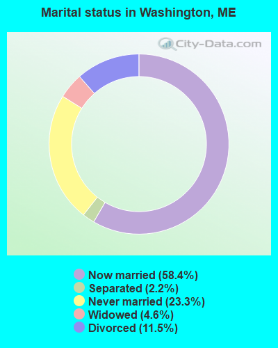
- Never married: 23.3%
- Now married: 58.4%
- Separated: 2.2%
- Widowed: 4.6%
- Divorced: 11.5%
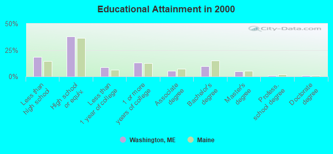
For population 25 years and over in Washington:
- High school or higher: 81.3%
- Bachelor's degree or higher: 16.3%
- Graduate or professional degree: 6.8%
- Unemployed: 5.1%
- Mean travel time to work (commute): 29.7 minutes
| Here: | 10.9 |
| Maine average: | 11.2 |
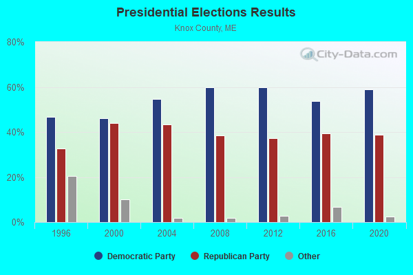
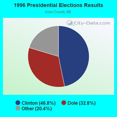
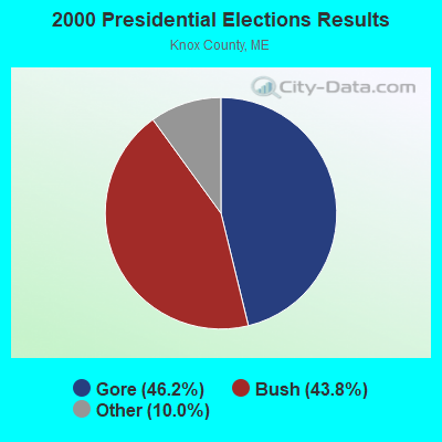
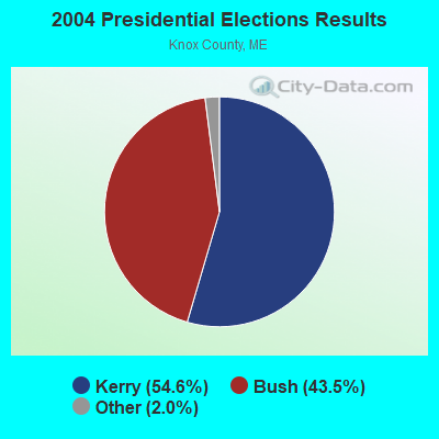

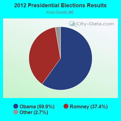
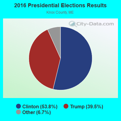
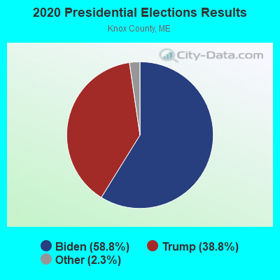
Graphs represent county-level data. Detailed 2008 Election Results
Religion statistics for Washington, ME (based on Knox County data)
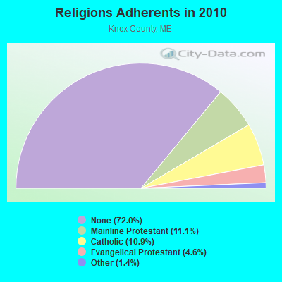
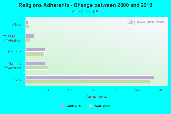
| Religion | Adherents | Congregations |
|---|---|---|
| Mainline Protestant | 4,400 | 29 |
| Catholic | 4,340 | 4 |
| Evangelical Protestant | 1,813 | 23 |
| Other | 569 | 6 |
| None | 28,614 | - |
Food Environment Statistics:
| Knox County: | 4.17 / 10,000 pop. |
| Maine: | 2.80 / 10,000 pop. |
| Knox County: | 2.21 / 10,000 pop. |
| Maine: | 2.20 / 10,000 pop. |
| This county: | 7.37 / 10,000 pop. |
| State: | 5.75 / 10,000 pop. |
| This county: | 19.40 / 10,000 pop. |
| Maine: | 11.02 / 10,000 pop. |
| Here: | 7.8% |
| State: | 8.2% |
| This county: | 21.6% |
| Maine: | 25.0% |
Strongest AM radio stations in Washington:
- WFAU (1280 AM; 5 kW; GARDINER, ME; Owner: CAPSTAR TX LIMITED PARTNERSHIP)
- WSKW (1160 AM; 10 kW; SKOWHEGAN, ME; Owner: MOUNTAIN WIRELESS, INCORPORATED)
- WTME (780 AM; 10 kW; RUMFORD, ME; Owner: MOUNTAIN VALLEY BROADCASTING, INC.)
- WZON (620 AM; 5 kW; BANGOR, ME; Owner: THE ZONE CORPORATION)
- WRKO (680 AM; 50 kW; BOSTON, MA; Owner: ENTERCOM BOSTON LICENSE, LLC)
- WRKD (1450 AM; 1 kW; ROCKLAND, ME; Owner: CLEAR CHANNEL BROADCASTING LICENSES, INC.)
- WABI (910 AM; 5 kW; BANGOR, ME; Owner: CLEAR CHANNEL BROADCASTING LICENSES, INC.)
- WMTW (870 AM; 10 kW; GORHAM, ME; Owner: RADIO PARTNERS OF MAINE, L.P.)
- WGAN (560 AM; 5 kW; PORTLAND, ME; Owner: SAGA COMMUNICATIONS OF NEW ENGLAND, LLC)
- WMDR (1340 AM; 1 kW; AUGUSTA, ME; Owner: LIGHT OF LIFE MINISTRIES, INC.)
- WEEI (850 AM; 50 kW; BOSTON, MA; Owner: ENTERCOM BOSTON LICENSE, LLC)
- WBZ (1030 AM; 50 kW; BOSTON, MA; Owner: INFINITY BROADCASTING OPERATIONS, INC.)
- WEZW (1400 AM; 1 kW; AUGUSTA, ME; Owner: CITADEL BROADCASTING COMPANY)
Strongest FM radio stations in Washington:
- WMEP (90.5 FM; CAMDEN, ME; Owner: MAINE PUBLIC BROADCASTING CORP.)
- WQSS (102.5 FM; CAMDEN, ME; Owner: CLEAR CHANNEL BROADCASTING LICENSES, INC.)
- WMCM (103.3 FM; ROCKLAND, ME; Owner: CLEAR CHANNEL BROADCASTING LICENSES, INC.)
- WBQX (106.9 FM; THOMASTON, ME; Owner: MARINER BROADCASTING LIMITED PARTNER)
- WMME-FM (92.3 FM; AUGUSTA, ME; Owner: CITADEL BROADCASTING COMPANY)
- WWWA (95.3 FM; WINSLOW, ME; Owner: LIGHT OF LIFE MINISTRIES, INC.)
- WFZX (101.7 FM; SEARSPORT, ME; Owner: CLEAR CHANNEL BROADCASTING LICENSES, INC.)
- WWBX (97.1 FM; BANGOR, ME; Owner: CLEAR CHANNEL BROADCASTING LICENSES, INC.)
- WBFB (104.7 FM; BELFAST, ME; Owner: CLEAR CHANNEL BROADCASTING LICENSES, INC.)
- WTOS-FM (105.1 FM; SKOWHEGAN, ME; Owner: CAPSTAR TX LIMITED PARTNERSHIP)
- WCME (96.7 FM; BOOTHBAY HARBOR, ME; Owner: CAPSTAR TX LIMITED PARTNERSHIP)
- WERU-FM (89.9 FM; BLUE HILL, ME; Owner: SALT POND COMMUNITY B/C COMPANY)
- WKIT-FM (100.3 FM; BREWER, ME; Owner: THE ZONE CORPORATION)
- WCYI (93.9 FM; LEWISTON, ME; Owner: CITADEL BROADCASTING COMPANY)
- WHQO (107.9 FM; SKOWHEGAN, ME; Owner: MOUNTAIN WIRELESS, INC.)
- WABK-FM (104.3 FM; GARDINER, ME; Owner: CAPSTAR TX LIMITED PARTNERSHIP)
- WMEW (91.3 FM; WATERVILLE, ME; Owner: MAINE PUBLIC BROADCASTING CORPORATION)
- WBYA (105.5 FM; ISLESBORO, ME; Owner: MARINER BROADCASTING LIMTED PARTNERSHIP)
- WCTB (93.5 FM; FAIRFIELD, ME; Owner: MOUNTAIN WIRELESS, INC.)
- WBCI (105.9 FM; BATH, ME; Owner: BLOUNT COMMUNICATIONS, INC.)
TV broadcast stations around Washington:
- WPFO (Channel 23; WATERVILLE, ME; Owner: CMCG PORTLAND LICENSE LLC)
- WCBB (Channel 10; AUGUSTA, ME; Owner: MAINE PUBLIC BROADCASTING CORP.)
- W64BY (Channel 64; ROCKLAND, ME; Owner: CRAIG MINISTRIES, INC.)
- WFYW-LP (Channel 69; FAIRFIELD/WATERVILLE, ME; Owner: THREE ANGELS BROADCASTING NETWORK, INC.)
- DW23AB (Channel 23; WATERVILLE, ME; Owner: RUSSELL COMMUNICATIONS)
- Washington, Maine
- Fatal accident count13
- Vehicles involved in fatal accidents21
- Fatal accidents involving drunk persons:7
- Fatalities14
- Persons involved in fatal accidents39
- Pedestrians involved in fatal accidents0
- Maine average
- Fatal accident count2057
- Vehicles involved in fatal accidents2930
- Fatal accidents involving drunk persons860
- Fatalities2245
- Persons involved in fatal accidents4945
- Pedestrians involved in fatal accidents126
- National Bridge Inventory (NBI) Statistics
- 5Number of bridges
- 20ft / 5.6mTotal length
- 12,418Total average daily traffic
- 619Total average daily truck traffic
- 14,953Total future (year 2036) average daily traffic
FCC Registered Antenna Towers:
8 (See the full list of FCC Registered Antenna Towers in Washington)FCC Registered Broadcast Land Mobile Towers:
2- 2 Shepard Hill Rd (Lat: 44.272861 Lon: -69.363944), Type: Tower, Structure height: 21 m, Call Sign: WPGN351,
Assigned Frequencies: 453.550 MHz, Grant Date: 01/04/2005, Expiration Date: 02/08/2015, Cancellation Date: 04/11/2015, Registrant: Radio Communications Management, 158 Rand Rd, Portland, ME 04103, Phone: (207) 797-7503, Email:
- Lat: 44.273750 Lon: -69.363472, Call Sign: WQNA399,
Assigned Frequencies: 156.217 MHz, Grant Date: 11/20/2020, Expiration Date: 11/23/2030, Certifier: Donald L Grinnell, Registrant: Radio Communications Management, 158 Rand Rd, Portland, ME 04102, Phone: (207) 797-7503, Email:
FCC Registered Microwave Towers:
1- Washington, Route 220 (Lat: 44.282778 Lon: -69.366389), Type: Mast, Structure height: 59.4 m, Call Sign: WQSZ793,
Assigned Frequencies: 10735.0 MHz, 10735.0 MHz, 10735.0 MHz, 10735.0 MHz, 10735.0 MHz, 10735.0 MHz, 10735.0 MHz, 10735.0 MHz, 10735.0 MHz, Grant Date: 12/16/2013, Expiration Date: 12/16/2023, Cancellation Date: 03/12/2019, Certifier: Jessica B Lyons, Registrant: At&t Mobility LLC, 1120 20th Street, Nw, Suite 1000, Washington, DC 20036, Phone: (202) 457-2055, Email:
FCC Registered Amateur Radio Licenses:
6- Call Sign: KA1SLY, Grant Date: 11/15/1988, Expiration Date: 11/15/1998, Cancellation Date: 11/16/2000, Registrant: Philip A Scribner, Rr 1 Box 654, Washington, ME 04574
- Call Sign: KC1CG, Licensee ID: L00109776, Grant Date: 03/07/2017, Expiration Date: 03/13/2027, Registrant: Edward C Rotch, Washington, ME 04574
- Call Sign: N1MSD, Licensee ID: L00550925, Grant Date: 07/26/2002, Expiration Date: 06/09/2012, Cancellation Date: 06/10/2014, Certifier: Charles W Robinson, Registrant: Charles W Robinson, 93 Fitch Road, Washington, ME 04574
- Call Sign: N6ERK, Previous Call Sign: KA6OLM, Licensee ID: L00268547, Grant Date: 08/02/2010, Expiration Date: 08/07/2020, Cancellation Date: 08/09/2022, Certifier: Richard D Bernhardt, Registrant: Richard D Bernhardt, 369 Old Union Rd, Washington, ME 04574
- Call Sign: KB1WBK, Licensee ID: L01661765, Grant Date: 09/16/2011, Expiration Date: 09/16/2021, Cancellation Date: 09/19/2023, Certifier: Donald L Grinnell, Registrant: Donald L Grinnell, 74 Liberty Rd, Washington, ME 04574
- Call Sign: KC1NKI, Licensee ID: L02358560, Grant Date: 07/08/2020, Expiration Date: 07/08/2030, Certifier: Jeffrey S Wooden, Registrant: Jeffrey S Wooden, 658 Liberty Rd, Washington, ME 04574
2003 - 2018 National Fire Incident Reporting System (NFIRS) incidents
- Fire incident types reported to NFIRS in Washington, ME
- 11061.8%Structure Fires
- 4223.6%Outside Fires
- 2212.4%Mobile Property/Vehicle Fires
- 42.2%Other
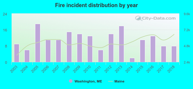 According to the data from the years 2003 - 2018 the average number of fire incidents per year is 11. The highest number of reported fires - 19 took place in 2005, and the least - 2 in 2014. The data has a declining trend.
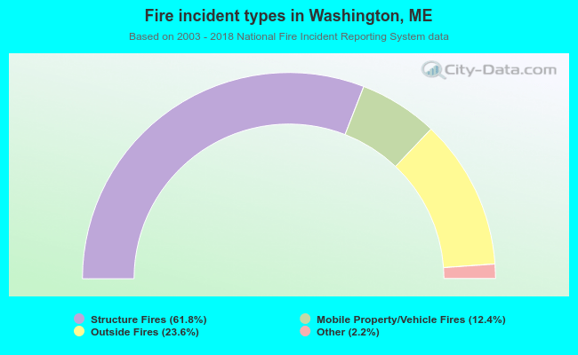 When looking into fire subcategories, the most reports belonged to: Structure Fires (61.8%), and Outside Fires (23.6%).
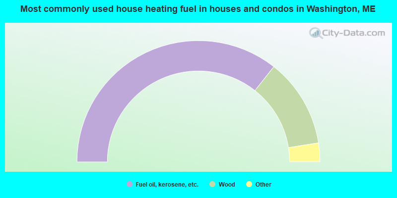
- 71.3%Fuel oil, kerosene, etc.
- 23.7%Wood
- 2.4%Bottled, tank, or LP gas
- 1.3%Utility gas
- 0.9%Solar energy
- 0.4%Coal or coke
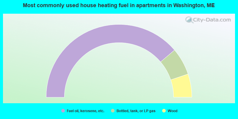
- 77.6%Fuel oil, kerosene, etc.
- 12.1%Bottled, tank, or LP gas
- 10.3%Wood
Washington compared to Maine state average:
- Unemployed percentage below state average.
- Black race population percentage significantly below state average.
- Hispanic race population percentage significantly below state average.
- Foreign-born population percentage significantly below state average.
- Renting percentage below state average.
- Length of stay since moving in significantly above state average.
- Number of rooms per house significantly below state average.
- House age significantly below state average.
- Institutionalized population percentage above state average.
- Percentage of population with a bachelor's degree or higher below state average.