West Juab, Utah
Submit your own pictures of this place and show them to the world
- OSM Map
- General Map
- Google Map
- MSN Map

| Males: 153 | |
| Females: 156 |
| Median resident age: | 25.0 years |
| Utah median age: | 27.1 years |
| West Juab: | $41,980 |
| UT: | $89,168 |
Estimated per capita income in 2022: $18,183 (it was $7,087 in 2000)
West Juab CCD income, earnings, and wages data
Estimated median house or condo value in 2022: $80,435 (it was $23,200 in 2000)
| West Juab: | $80,435 |
| UT: | $499,500 |
Mean prices in 2022: all housing units: $416,900; detached houses: $427,326; townhouses or other attached units: $411,210; in 2-unit structures: $367,214; in 3-to-4-unit structures: $333,288; mobile homes: $92,413
Detailed information about poverty and poor residents in West Juab, UT
Compare current foreclosures near your location:
| Photo | Address | Area | Beds / Baths | Price | Details |
|---|---|---|---|---|---|

|
#1
N Rhodes St
Pretty Prairie, KS 67570
|
1,725 sq. feet
|
2 baths 4 beds |
show details | |

|
#2
S Goddard Rd
Goddard, KS 67052
|
1,054 sq. feet
|
2 baths 2 beds |
show details | |

|
#3
W 21st St N
Cheney, KS 67025
|
3,190 sq. feet
|
3 baths 5 beds |
show details | |

|
#4
E Winterset St
Goddard, KS 67052
|
816 sq. feet
|
1 baths 2 beds |
show details | |

|
#5
NE Waterloo Ave
Murdock, KS 67111
|
1,220 sq. feet
|
1 baths 3 beds |
show details | |

|
#6
W 39th St S
Goddard, KS 67052
|
4,221 sq. feet
|
3 baths 3 beds |
show details | |

|
#7
E Arlington Rd
Haven, KS 67543
|
960 sq. feet
|
1 baths 2 beds |
show details | |

|
#8
S 391st St W
Cheney, KS 67025
|
2,558 sq. feet
|
3 baths 3 beds |
show details | |

|
#9
SE Viney Ave
Murdock, KS 67111
|
- sq. feet
|
- baths - beds |
show details | |

|
#10
W Main St
Mount Hope, KS 67108
|
- sq. feet
|
- baths - beds |
show details |
| Photo | Address | Area | Beds / Baths | Price | Details |
|---|---|---|---|---|---|

|
#11
N 189th Cir W
Colwich, KS 67030
|
- sq. feet
|
- baths - beds |
show details | |

|
#12
N Main St
Goddard, KS 67052
|
- sq. feet
|
- baths - beds |
show details | |

|
#13
Martens Ct
Goddard, KS 67052
|
- sq. feet
|
- baths - beds |
show details | |

|
#14
E 4th Ave Apt 1
Cheney, KS 67025
|
- sq. feet
|
- baths - beds |
show details | |

|
#15
W Maple St Lot D
Goddard, KS 67052
|
- sq. feet
|
- baths - beds |
show details | |

|
#16
W 47th St S
Garden Plain, KS 67050
|
- sq. feet
|
- baths - beds |
show details | |

|
#17
S 339th St W
Cheney, KS 67025
|
- sq. feet
|
- baths - beds |
show details | |

|
#18
E Casey Dr
Goddard, KS 67052
|
- sq. feet
|
- baths - beds |
show details | |

|
Check over 1 million property listings on Foreclosure.com!
|
browse all offers | |||

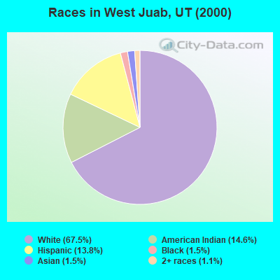
- 18167.5%White alone
- 3914.6%American Indian alone
- 3713.8%Hispanic
- 41.5%Black alone
- 41.5%Asian alone
- 31.1%Two or more races
Races in West Juab detailed stats: ancestries, foreign born residents, place of birth
 Recent articles from our blog. Our writers, many of them Ph.D. graduates or candidates, create easy-to-read articles on a wide variety of topics.

Current Local Time: MST time zone
Land area: 2009.0 square miles.
Population density: 0.2 people per square mile (very low).

| West Juab CCD: | 0.9% ($199) |
| Utah: | 0.7% ($956) |
Nearest city with pop. 50,000+: West Jordan, UT  (82.5 miles , pop. 68,336).
Nearest city with pop. 200,000+: Las Vegas, NV (274.4 miles , pop. 478,434).
Nearest city with pop. 1,000,000+: Phoenix, AZ (438.0 miles , pop. 1,321,045).
Nearest cities:
), ), ), Latitude: 39.80 N, Longitude: 113.13 W

| Here: | 2.3% |
| Utah: | 2.5% |
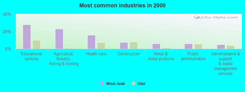
- Educational services (28.0%)
- Agriculture, forestry, fishing & hunting (23.2%)
- Health care (15.9%)
- Construction (7.3%)
- Metal & metal products (6.1%)
- Public administration (6.1%)
- Administrative & support & waste management services (4.9%)
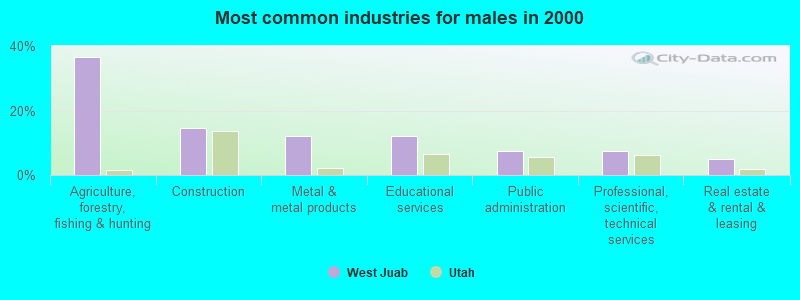
- Agriculture, forestry, fishing & hunting (36.6%)
- Construction (14.6%)
- Metal & metal products (12.2%)
- Educational services (12.2%)
- Public administration (7.3%)
- Professional, scientific, technical services (7.3%)
- Real estate & rental & leasing (4.9%)
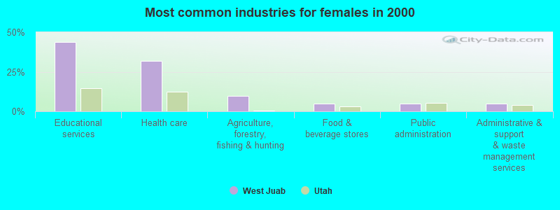
- Educational services (43.9%)
- Health care (31.7%)
- Agriculture, forestry, fishing & hunting (9.8%)
- Food & beverage stores (4.9%)
- Public administration (4.9%)
- Administrative & support & waste management services (4.9%)
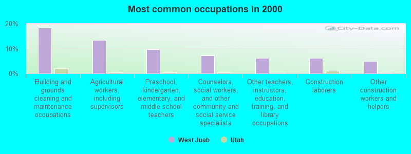
- Building and grounds cleaning and maintenance occupations (18.3%)
- Agricultural workers, including supervisors (13.4%)
- Preschool, kindergarten, elementary, and middle school teachers (9.8%)
- Counselors, social workers, and other community and social service specialists (7.3%)
- Other teachers, instructors, education, training, and library occupations (6.1%)
- Construction laborers (6.1%)
- Other construction workers and helpers (4.9%)
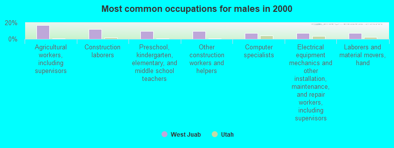
- Agricultural workers, including supervisors (17.1%)
- Construction laborers (12.2%)
- Preschool, kindergarten, elementary, and middle school teachers (9.8%)
- Other construction workers and helpers (9.8%)
- Computer specialists (7.3%)
- Electrical equipment mechanics and other installation, maintenance, and repair workers, including supervisors (7.3%)
- Laborers and material movers, hand (7.3%)
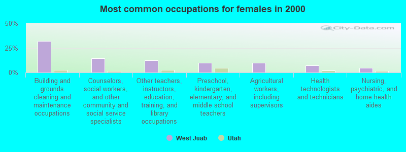
- Building and grounds cleaning and maintenance occupations (31.7%)
- Counselors, social workers, and other community and social service specialists (14.6%)
- Other teachers, instructors, education, training, and library occupations (12.2%)
- Preschool, kindergarten, elementary, and middle school teachers (9.8%)
- Agricultural workers, including supervisors (9.8%)
- Health technologists and technicians (7.3%)
- Nursing, psychiatric, and home health aides (4.9%)
Average climate in West Juab, Utah
Based on data reported by over 4,000 weather stations


Earthquake activity:
West Juab-area historical earthquake activity is significantly above Utah state average. It is 3113% greater than the overall U.S. average.On 10/3/1915 at 06:52:48, a magnitude 7.6 (7.6 UK, Class: Major, Intensity: VIII - XII) earthquake occurred 235.8 miles away from West Juab center
On 8/18/1959 at 06:37:13, a magnitude 7.7 (7.7 UK) earthquake occurred 352.9 miles away from the city center, causing $26,000,000 total damage
On 10/28/1983 at 14:06:06, a magnitude 7.3 (6.2 MB, 7.3 MS, 7.0 MW) earthquake occurred 297.5 miles away from the city center, causing 2 deaths (2 shaking deaths) and 3 injuries, causing $15,000,000 total damage
On 12/21/1932 at 06:10:09, a magnitude 7.2 (7.2 UK) earthquake occurred 280.2 miles away from West Juab center
On 12/16/1954 at 11:07:12, a magnitude 7.0 (7.0 UK) earthquake occurred 263.1 miles away from West Juab center
On 6/28/1992 at 11:57:34, a magnitude 7.6 (6.2 MB, 7.6 MS, 7.3 MW, Depth: 0.7 mi) earthquake occurred 431.7 miles away from the city center, causing 3 deaths (1 shaking deaths, 2 other deaths) and 400 injuries, causing $100,000,000 total damage and $40,000,000 insured losses
Magnitude types: body-wave magnitude (MB), surface-wave magnitude (MS), moment magnitude (MW)
Natural disasters:
The number of natural disasters in Juab County (6) is a lot smaller than the US average (15).Major Disasters (Presidential) Declared: 2
Emergencies Declared: 2
Causes of natural disasters: Floods: 2, Landslides: 2, Storms: 2, Drought: 1, Fire: 1, Hurricane: 1, Mudslide: 1, Other: 1 (Note: some incidents may be assigned to more than one category).
Colleges/universities with over 2000 students nearest to West Juab:
- Utah Valley University (about 82 miles; Orem, UT; Full-time enrollment: 24,403)
- Brigham Young University-Provo (about 85 miles; Provo, UT; FT enrollment: 33,525)
- Salt Lake Community College (about 87 miles; Salt Lake City, UT; FT enrollment: 20,797)
- Stevens-Henager College-Murray (about 88 miles; Murray, UT; FT enrollment: 6,395)
- Snow College (about 89 miles; Ephraim, UT; FT enrollment: 3,224)
- Western Governors University (about 91 miles; Salt Lake City, UT; FT enrollment: 31,481)
- Westminster College (about 94 miles; Salt Lake City, UT; FT enrollment: 2,870)
Points of interest:
Notable locations in West Juab: Willow Springs Station (A), Dugway Pony Express Station (B), Falkenberg Ranch (C), Granite Ranch (D), Hassel Ranch (E), Devils Hole (F), Keg Mountain Ranch (G), Fish Springs (H), Nooning Ground (I), Boyd Station (J), CCC Campground (K), Clyde Ranch (L), Partoun Fire Department (M), Callao Fire Department (N), Granite Ranch Fire Department (O). Display/hide their locations on the map
Church in West Juab: The Church of Jesus Christ of Latter Day Saints (A). Display/hide its location on the map
Cemetery: Callao Cemetery (1). Display/hide its location on the map
Lakes and reservoirs: Mile Pond (A), River Bed Reservoir Number 2 (B), Egret Pool (C), Dead Horse Tank (D), East Topaz 2 Reservoir (E), East Dugway Reservoir (F), Avocet Pool (G), Hogback Reservoir (H). Display/hide their locations on the map
Streams, rivers, and creeks: Indian Farm Creek (A), Trout Creek (B), Steves Creek (C), Swasey Knolls Wash (D), Toms Creek (E), Red Cedar Creek (F), Dry Lake Creek (G), Shadscale Canyon Trailer Wash (H), Dads Creek (I). Display/hide their locations on the map
Parks in West Juab include: Black Rock Pony Express Station Historical Marker (1), Fish Springs National Wildlife Refuge (2), Window Rock (3), Pony Express Monument (4). Display/hide their locations on the map
| This place: | 3.0 people |
| Utah: | 3.1 people |
| This place: | 71.0% |
| Whole state: | 75.2% |
| This place: | 4.8% |
| Whole state: | 4.6% |
No gay or lesbian households reported
| This place: | 30.8% |
| Whole state: | 9.4% |
| This place: | 16.3% |
| Whole state: | 3.9% |
For population 15 years and over in West Juab:
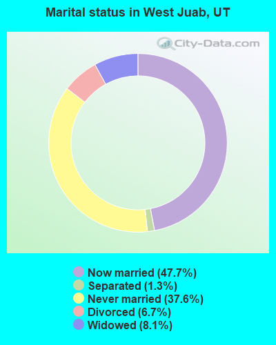
- Never married: 37.6%
- Now married: 47.7%
- Separated: 1.3%
- Widowed: 8.1%
- Divorced: 6.7%
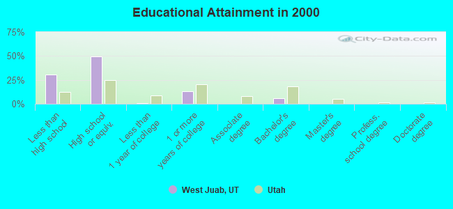
For population 25 years and over in West Juab:
- High school or higher: 69.6%
- Bachelor's degree or higher: 6.1%
- Graduate or professional degree: 0.0%
- Unemployed: 6.8%
- Mean travel time to work (commute): 11.0 minutes

| Here: | 8.9 |
| Utah average: | 10.5 |
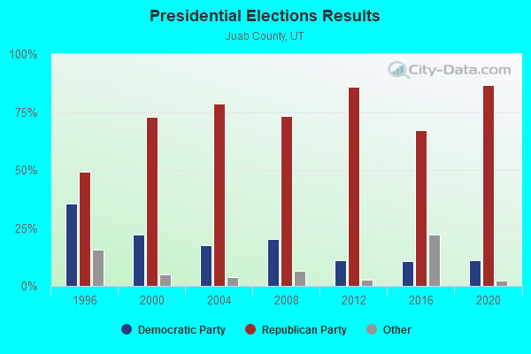

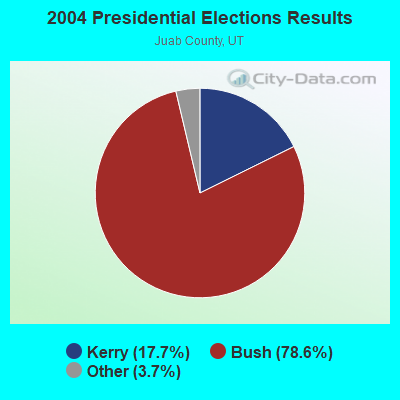
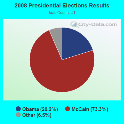
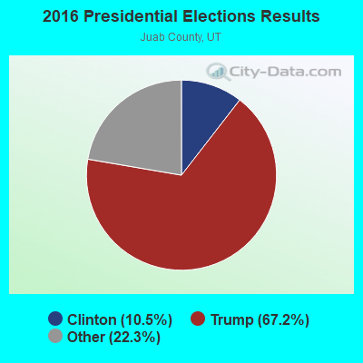
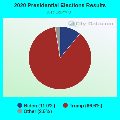
Graphs represent county-level data. Detailed 2008 Election Results
Religion statistics for West Juab, UT (based on Juab County data)
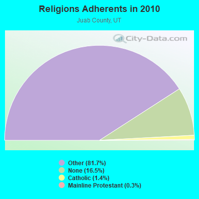
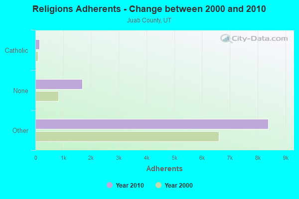
| Religion | Adherents | Congregations |
|---|---|---|
| Other | 8,374 | 19 |
| Catholic | 145 | 1 |
| Mainline Protestant | 32 | 1 |
| None | 1,695 | - |
Food Environment Statistics:
| This county: | 2.09 / 10,000 pop. |
| State: | 1.37 / 10,000 pop. |
| Here: | 6.27 / 10,000 pop. |
| Utah: | 2.82 / 10,000 pop. |
| This county: | 7.32 / 10,000 pop. |
| Utah: | 5.09 / 10,000 pop. |
| Here: | 6.9% |
| State: | 6.3% |
| Here: | 24.5% |
| Utah: | 23.6% |
Strongest AM radio stations in West Juab:
- KALL (700 AM; 50 kW; NORTH SALT LAKE CITY, UT; Owner: CITICASTERS LICENSES, L.P.)
- KIQN (1010 AM; 50 kW; TOOELE, UT)
- KSL (1160 AM; 50 kW; SALT LAKE CITY, UT; Owner: BONNEVILLE HOLDING COMPANY)
- KMTI (650 AM; 10 kW; MANTI, UT; Owner: SANPETE COUNTY BROADCASTING COMPANY)
- KTKK (630 AM; 10 kW; SANDY, UT; Owner: UNITED BROADCASTING COMPANY)
- KKDS (1060 AM; 10 kW; SOUTH SALT LAKE, UT; Owner: HOLIDAY BROADCASTING COMPANY)
- KBEE (860 AM; 10 kW; SALT LAKE CITY, UT; Owner: CITADEL BROADCASTING COMPANY)
- KLLB (1510 AM; daytime; 10 kW; WEST JORDAN, UT; Owner: UNITED SECURITY FINANCIAL, INC.)
- KNRS (570 AM; 5 kW; SALT LAKE CITY, UT; Owner: CITICASTERS LICENSES, L.P.)
- KWDZ (910 AM; 5 kW; SALT LAKE CITY, UT; Owner: ABC, INC.)
- KMRI (1550 AM; 10 kW; WEST VALLEY CITY, UT; Owner: KMRI RADIO, LLC)
- KXNT (840 AM; 50 kW; NORTH LAS VEGAS, NV; Owner: INFINITY RADIO OPERATIONS INC.)
- KDWN (720 AM; 50 kW; LAS VEGAS, NV; Owner: RADIO NEVADA CORP.)
Strongest FM radio stations in West Juab:
- KUUU (92.1 FM; TOOELE, UT; Owner: MILLCREEK BROADCASTING, L.L.C.)
- KXRK (96.3 FM; PROVO, UT; Owner: SIMMONS-SLC, LS, LLC)
- KQMB (102.7 FM; MIDVALE, UT; Owner: SIMMONS-SLC, LS, LLC)
- KSOP-FM (104.3 FM; SALT LAKE CITY, UT; Owner: KSOP, INC.)
- K272DP (102.3 FM; TOOELE, UT; Owner: FAMILY STATIONS, INC.)
- KRCL (90.9 FM; SALT LAKE CITY, UT; Owner: LISTENERS COMMUNITY RADIO OF UTAH)
- KBZN (97.9 FM; OGDEN, UT; Owner: CAPITOL BROADCASTING, INC.)
- KOSY-FM (106.5 FM; SPANISH FORK, UT; Owner: MERCURY BROADCASTING COMPANY, INC.)
- KRSP-FM (103.5 FM; SALT LAKE CITY, UT; Owner: SIMMONS-SLC, LS, LLC)
- KBER (101.1 FM; OGDEN, UT; Owner: CITADEL BROADCASTING COMPANY)
- KISN-FM (97.1 FM; SALT LAKE CITY, UT; Owner: CLEAR CHANNEL BROADCASTING LICENSES, INC.)
- KKAT (101.9 FM; OGDEN, UT; Owner: CITICASTERS LICENSES, L.P.)
- KSFI (100.3 FM; SALT LAKE CITY, UT; Owner: SIMMONS-SLC, LS, LLC)
- KUBL-FM (93.3 FM; SALT LAKE CITY, UT; Owner: CITADEL BROADCASTING COMPANY)
- KENZ (107.5 FM; OREM, UT; Owner: CITADEL BROADCASTING COMPANY)
- KODJ (94.1 FM; SALT LAKE CITY, UT; Owner: CITICASTERS LICENSES, L.P.)
- KZHT (94.9 FM; PROVO, UT; Owner: CITICASTERS LICENSES, L.P.)
- KUER-FM (90.1 FM; SALT LAKE CITY, UT; Owner: UNIVERSITY OF UTAH)
- KBYU-FM (89.1 FM; PROVO, UT; Owner: BRIGHAM YOUNG UNIVERSITY)
- KURR (99.5 FM; BOUNTIFUL, UT; Owner: CITICASTERS LICENSES, L.P.)
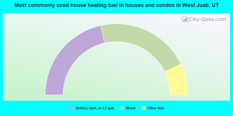
- 42.9%Bottled, tank, or LP gas
- 42.9%Wood
- 14.3%Other fuel
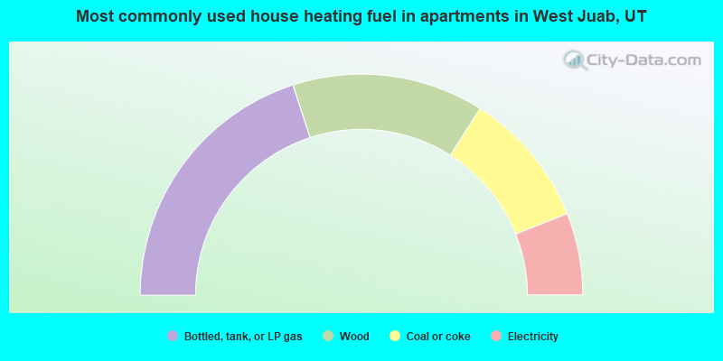
- 40.0%Bottled, tank, or LP gas
- 28.0%Wood
- 20.0%Coal or coke
- 12.0%Electricity
West Juab compared to Utah state average:
- Median household income below state average.
- Median house value significantly below state average.
- Unemployed percentage below state average.
- Black race population percentage above state average.
- Median age below state average.
- Foreign-born population percentage significantly below state average.
- Renting percentage above state average.
- Length of stay since moving in significantly above state average.
- Number of rooms per house significantly below state average.
- House age significantly below state average.
- Number of college students significantly below state average.
- Percentage of population with a bachelor's degree or higher significantly below state average.
West Juab on our top lists:
- #40 on the list of "Top 100 highest located cities (pop. 50,000+)"
- #47 on the list of "Top 100 cities with largest land areas"
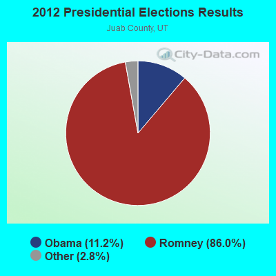
- #46 on the list of "Top 101 counties with highest percentage of residents voting for Romney (Republican) in the 2012 Presidential Election"